Embed Size (px)
Citation preview
1
ICICLE CREEK
AND THE LEAVENWORTH NATIONAL FISH HATCHERY
January 12, 2014
Over the past ten years and possibly more, the U.S. Fish and Wildlife Service (USFWS) and possibly the Washington State Department of Ecology (DOE) have referred to the Leavenworth National Fish Hatchery (LNFH) Canal as Icicle Creek. The natural bed of Icicle Creek is often referred to by an increasing number of people, as the “side channel”, implying that it is a lesser channel of Icicle Creek. The use of this descriptive language has led to confusion about which channel (the Hatchery’s Canal or the natural bed of Icicle Creek) is Icicle Creek. Clarifying this confusion is essential to solving current attempts being made on how to more effectively manage Icicle Creek water. In order to fully appreciate how we arrived at the present stage it is essential to understand the historical relationship between Icicle Creek and the Leavenworth National Fish Hatchery. This forty-two page summary is a brief history of the relationship between Icicle Creek and the Leavenworth National Fish Hatchery.
2
BEFORE HATCHERY CONSTRUCTION There is some photographic evidence, along with survey maps and other information to give us an idea of what this area looked like before the Leavenworth National Fish Hatchery was constructed.
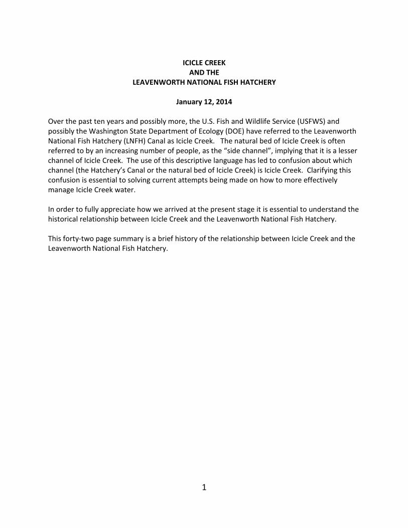
(Figure 1) This photo is of two early survey maps of Icicle Creek taped together along the line pointed to by the red arrow. Both maps were surveyed in 1892. The red bracket shows the reach between RM 3.8 and RM 2.8 of the natural bed of Icicle Creek. The blue dotted line shows where the Hatchery Canal was built. The yellow arrow points to the name of the stream (Icicle Cr.) This survey was taken 46 years before the Hatchery Canal was built. The reach in the bracket has recently been referred to as the “side channel” of Icicle Creek. In 1892 this reach was accepted as Icicle Creek.
3
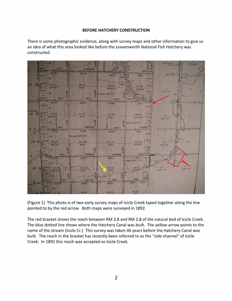
(Figure 2) This photo was taken around 1925 facing southwest (before construction of the Hatchery) of Icicle Creek from the west-facing hillside above the stream and to the east of the stream. Harriet Bullitt’s current residence can barely be seen located across the river in the upper right ¼ of the photo (circled in blue) The area appears to have been logged. A wagon road can be seen approaching the building. Most of this road exists today. Two red parallel dotted lines are drawn where the canal was built in 1939.
4
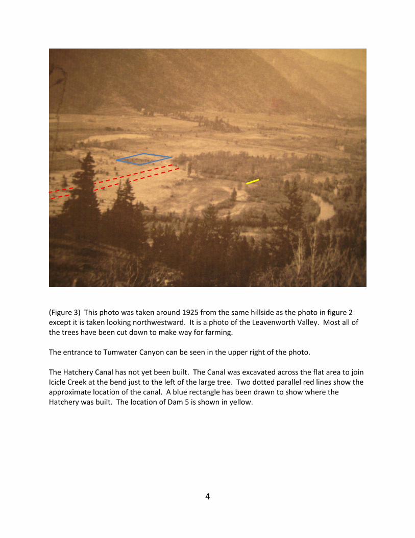
(Figure 3) This photo was taken around 1925 from the same hillside as the photo in figure 2 except it is taken looking northwestward. It is a photo of the Leavenworth Valley. Most all of the trees have been cut down to make way for farming. The entrance to Tumwater Canyon can be seen in the upper right of the photo. The Hatchery Canal has not yet been built. The Canal was excavated across the flat area to join Icicle Creek at the bend just to the left of the large tree. Two dotted parallel red lines show the approximate location of the canal. A blue rectangle has been drawn to show where the Hatchery was built. The location of Dam 5 is shown in yellow.
5
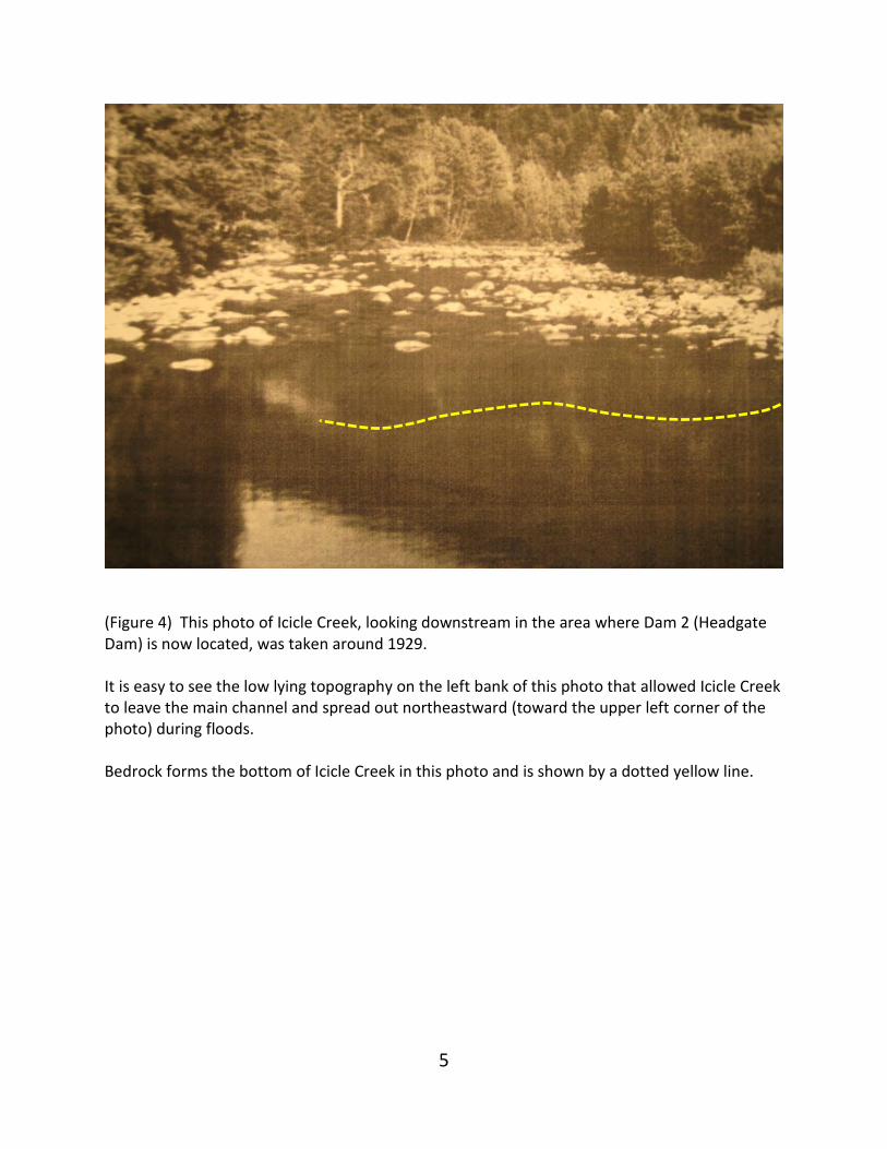
(Figure 4) This photo of Icicle Creek, looking downstream in the area where Dam 2 (Headgate Dam) is now located, was taken around 1929. It is easy to see the low lying topography on the left bank of this photo that allowed Icicle Creek to leave the main channel and spread out northeastward (toward the upper left corner of the photo) during floods. Bedrock forms the bottom of Icicle Creek in this photo and is shown by a dotted yellow line.
6
EARLY HISTORY BEGINNING IN 1938 - 1979 The original hatchery held anadromous fish in holding ponds located in the natural bed of Icicle Creek between Dam 2 and Dam 5. In 1938 a Canal was built to divert flood water in excess of 200 cfs around the holding ponds to keep flood waters from destroying the holding pond structures and keep fish held in the holding ponds from being swept downstream. The Hatchery abandoned the holding pond system for a fish ladder and two cement holding ponds in 1979. An important historical document was written in the form of a report in January 1938. The report is titled, “Report of the Preliminary Investigations into the Possible Methods of Preserving the Columbia River Salmon and Steelhead at the Grand Coulee Dam”. The report was prepared by the State of Washington Department of Fisheries in cooperation with the Department of Game and the United States Bureau of Fisheries for the United States Bureau of Reclamation. This 118 page report is often referred to as the Brennan Report named after B. M. Brennan, Director of Fisheries. The Brennan Report gives insight into the thinking that outlined how the LNFH would be constructed. On page 45 of the Brennan Report the Report makes recommendations for how returning adult anadromous fish would be held until they were ready to spawn:
“The adult fish when they arrive at Rock Island Dam are not ready to spawn. They will have to be held from two weeks to six months to ripen. This holding period is perhaps the most crucial point in the proposed hatchery plan. The difficulty in designing holding ponds for the quality of fish that must be handled is enhanced by the almost complete lack of knowledge of the actions of the fish in a natural state … Perhaps it is necessary for the Chinook and steelhead to have a certain strength of current to fight against to use the stored up energy and complete the physiological process known as ripening ….”
“The same problem was faced in the Lewis River when a hydroelectric dam was placed across it stopping the spawning migrations of the fish. There a holding pond was constructed in a small creek adjacent to the hatchery …. The system is not eminently satisfactory. Considerable numbers of adult fish die before spawning. There is a large mortality among the eggs and alevins in the hatchery. The cause of these mortalities has not as yet been determined, but it may be that the holding in this artificial pond is a contributing cause to the death of the adults and the lessened viability of the eggs and young.”
On page 46 of the Brennan Report two plans were proposed for the Leavenworth National Fish Hatchery. The implementation of the chosen plan, unbeknown to the planners at that time, set the stage for the debates we are having today. Their knowledge about how to rear anadromous fish was severely limited. Here is a small portion of the report beginning on page 46:

7
“Two plans have been proposed for holding the adult fish at Leavenworth. One entails the construction of purely artificial pools near the hatchery; the other considers using the bed of Icicle Creek. In view of the lack of knowledge of the success of the artificial pond at Lewis River, it is believed that the natural condition of the stream during the holding period should be duplicated as closely as possible. It is recommended that the natural bed of Icicle Creek be used for the holding ponds.”
The large meander of Icicle Creek between Sleeping Lady Retreat and East Leavenworth Road turned out to be a perfect location for what the Department of fisheries had in mind. Here is the Brennan Report again page 49:
“The preference by the fish of that section of the creek between the CCC pool and the lower rack was quite plain. It is believed that this section of the creek will provide ample space for the ripening of the 34,000 fish expected as a maximum at any one time. Therefore, it is recommended that that section of Icicle Creek between the site of the lower rack of this summer’s experiment, and the riffle above the first pool below the pool at the CCC camp be reserved and developed for holding ponds for the adult fish.”
The CCC camp is where Sleeping Lady Resort is located today. The lower rack was about one mile below the present location of the Hatchery. The Brennan Report goes on, page 49:
“An objection to the use of Icicle Creek for holding is the fact that it is subject to floods of such magnitude as would render it useless for holding during the spring and sometimes in the late fall. In the spring there will be chinook and steelhead in the holding area at the flood time; and in the fall there will be steelhead. To eliminate the difficulty created by these flood stages it is recommended that a by-pass be provided to divert these flood waters around the holding area defined above. It is recommended that this channel be of such a size that, excepting on the unusual floods occurring about once in 25 years, no more, than 200 c.f.s. will have to be taken through the holding area. This by-pass must be provided with controls at the upper end so that the amount of water flowing down it can be regulated or completely shut off. It may be necessary to do some channel improvement work on the lower Icicle Creek to provide a quicker run-off for the flood waters carried by this diversion so that during extreme peaks the lower pool will not be flooded out by the backwater. This diversion will be in the neighborhood of 4,000 feet long and will need to carry about 5,000 c.f.s. of water. The holding area should be provided with: 1. a control dam at the head-end by which the amount of water going through the holding area can be regulated. 2. A dam at the lower end proceeded by a rack so that the fish will not be able to escape downstream and so that the velocity of the water going through the rack will not be great enough to cause injury to the fish. This rack will need to be so constructed that at the extreme flood stages the backwater will not flood over its top. Provision must be made to allow
8
fish to come up from downstream in order that if it becomes possible in later years to do away with the trapping at the Rock Island Dam the fish ascending the stream naturally can be accommodated at no extra cost. The low dam at this point should also be constructed with a view to taking fish over it in future years. 3. Certain racks, diffusion chambers, and, perhaps, low dams as will be needed to segregate the fish and facilitate their collection for ripening and spawning purposes. With the exception of the diffusion chambers, which must pass only 200 cfs, these structures should be designed to permit the passage of 1,000 cfs for a short period for the purposes of cleaning, etc. 4. Certain facilities for the spawn-taking operations such as roadways to the spawning grounds, seining grounds, sheds for tool storage and shelter from the sun, waste disposal facilities, piped water supply, egg hardening, and washing troughs, fish bins, etc. The specific recommendations for these improvements in the holding area are dependent upon a knowledge of the contours of the creek and its banks and complete engineering data not available at present.”
Finally, the Brennan report addresses the need for additional water. They recognized, at that early date, there was not enough water for their proposal. Here is what the report said, page 50:
“As nearly as could be estimated from watching the creek and fish this summer under flows varying from 20 cfs to about 1,000 cfs, it is estimated that a flow of about 100 cfs will be required as an absolute minimum to safely care for the quantity of fish expected. This will leave about 1-1/3 gallons of water per minute per fish, at maximum concentrations. Since this is only slightly under the normal flow of the creek at this time of year, there will be current velocities comparable with those found under normal conditions. The deviations from natural conditions will be small. At present there is not 100 cfs of water flowing in Icicle Creek during all of the irrigation season. In the canyon above the recommended holding area, two irrigation ditches, one diverting 110 cfs and the other 15 cfs, take water from the stream. As a consequence, in the latter part of July, in August, September and October, the quantity of water flowing through the holding area will be much less than that required. This summer it went as low as 20 cfs. Therefore, it will be necessary to acquire more of the natural flow of the Icicle and, at times all of the low flow. The Wenatchee River in Tumwater Canyon, as shown in Table 19, reaches temperatures of as much as 700 F. and for a considerable period maintains a temperature of more than 600 F. This period of high temperatures comes at the time (in August and September) when there will be a maximum of fish in the holding area. The experiments at Monitor this summer and the 1935 experiments in holding fish at Rock Island strongly indicate that water of this temperature will induce excessive mortalities if used to hold the fish with which we are dealing until spawning time. Therefore, during the summer and fall it is recommended that Wenatchee River water not be used in the holding area.
9
The large Icicle irrigation ditch (carrying 110 cfs) runs close to the head end of the recommended holding area, but on the hillside above. The contours of Tumwater Canyon and Icicle Flats are such that a gravity flow diversion can bring water from the Wenatchee River to the head end of the holding area. It is therefore recommended that an exchange of Wenatchee River water for Icicle Creek water (which has a lower summer temperature, see Table 19) be made with the ditch company with a view toward using the total natural flow of Icicle Creek, if necessary. At such times as the temperature of the Wenatchee river water is unsuitable for the holding area, it should be pumped into the irrigation ditch in exchange for an equal amount of Icicle Creek water. It is further recommended that the diversion from the Wenatchee River shall be of such a size that 100 cfs of water over and above that required for exchange with the irrigation company can be provided in order that if it is found after experience that more water is needed in the holding area, or some contingency arises whereby more water is needed for a short period, it can be available without further development.”
All of the structures recommended in this section of the Brennan Report were built except for the pumps and pipes needed to pump Wenatchee River water from the south end of the Wenatchee Canal to the Icicle District irrigation canal in exchange for the District’s Icicle Creek water.
The following pages are a series of photos showing construction specifically related to the Hatchery’s Canal.
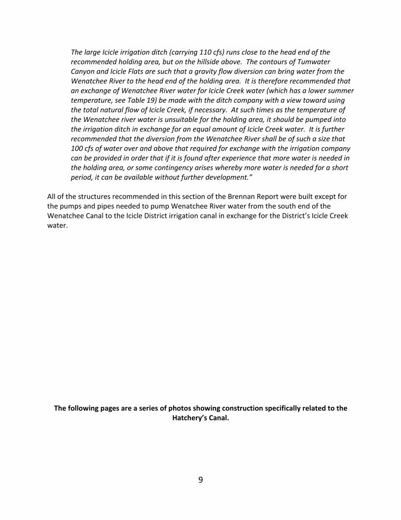
10
(Figure 5a) Figure 5a shows a longitudinal section of the topography of Icicle Creek before the canal and holding ponds were built. It shows the proposed location of Dam 2, 3, 4 and 5 with a profile of Icicle Creek and the locations of test pits along the Canal’s centerline and at the three dams. A blue arrow shows flow direction. Figure 5a shows the Canal beginning at the south end at the elevation of Icicle Creek bed (1124 feet), and rising to elevation 1125 over a short distance and then sloping on a slightly descending grade ending at elevation 1124 feet by the time it reaches the spillway dam. The top of the spillway dam is at elevation 1129 feet. Over the years, the bottom of the Canal has silted in so that it is currently at elevation 1129 feet near the south end and slopes upward to about elevation 1129.5 at the spillway dam. When water is not entering the canal, water drains south into Icicle Creek.
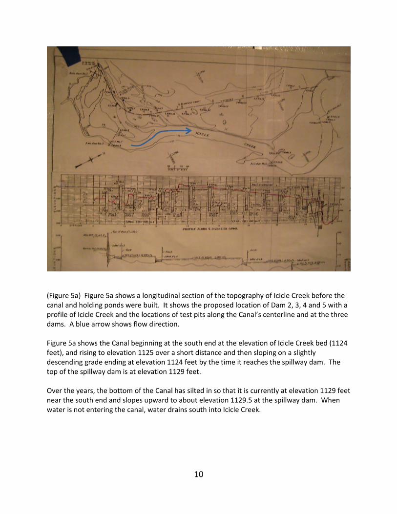
11
(Figure 5b) Figure 5b is an enlargement of the far right of Figure 5a so the note indicating 10,000 cfs when the water surface is at elevation 1139 feet can be seen. It is clear that the canal was designed to receive 10,000 cfs. A blue arrow points to the top of the spillway dam.
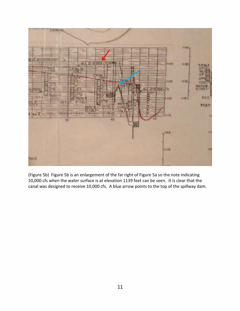
12
(Figure 6) This is a photo of the south end of the Hatchery Canal looking south in the winter of 1939. The Canal is close to being completed. Icicle Creek has been crowded in its natural bed against its southern shore by a dike so that work on the canal can proceed. The dike on the left side of the canal has been completed. Harriet Bullitt’s current residence is the building in the background. Dam 2 is located behind the dike and is not visible. Dam 2 is located at the end of the vertical blue arrow. When Dam 2 is closed Icicle Creek water flows into the Canal. An arrow shows the direction of flow when Dam 2 gates are closed.
13
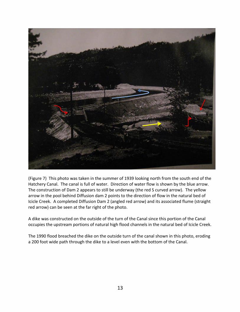
(Figure 7) This photo was taken in the summer of 1939 looking north from the south end of the Hatchery Canal. The canal is full of water. Direction of water flow is shown by the blue arrow. The construction of Dam 2 appears to still be underway (the red S curved arrow). The yellow arrow in the pool behind Diffusion dam 2 points to the direction of flow in the natural bed of Icicle Creek. A completed Diffusion Dam 2 (angled red arrow) and its associated flume (straight red arrow) can be seen at the far right of the photo. A dike was constructed on the outside of the turn of the Canal since this portion of the Canal occupies the upstream portions of natural high flood channels in the natural bed of Icicle Creek. The 1990 flood breached the dike on the outside turn of the canal shown in this photo, eroding a 200 foot wide path through the dike to a level even with the bottom of the Canal.
14
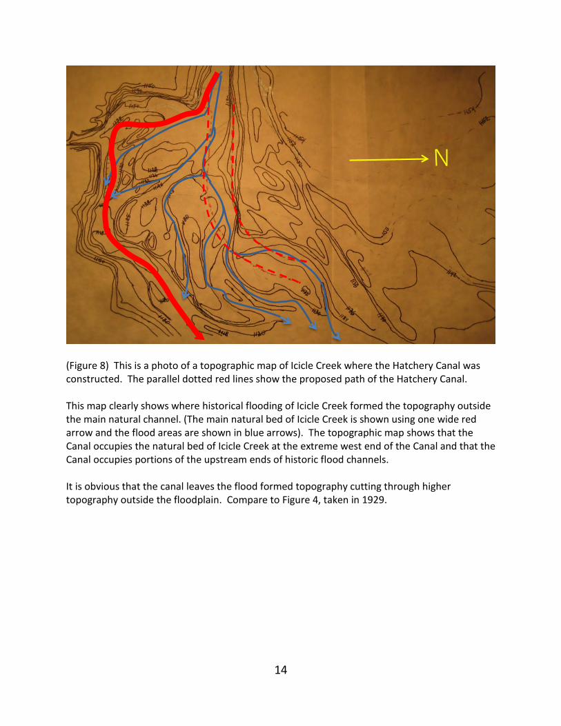
(Figure 8) This is a photo of a topographic map of Icicle Creek where the Hatchery Canal was constructed. The parallel dotted red lines show the proposed path of the Hatchery Canal. This map clearly shows where historical flooding of Icicle Creek formed the topography outside the main natural channel. (The main natural bed of Icicle Creek is shown using one wide red arrow and the flood areas are shown in blue arrows). The topographic map shows that the Canal occupies the natural bed of Icicle Creek at the extreme west end of the Canal and that the Canal occupies portions of the upstream ends of historic flood channels. It is obvious that the canal leaves the flood formed topography cutting through higher topography outside the floodplain. Compare to Figure 4, taken in 1929.
15
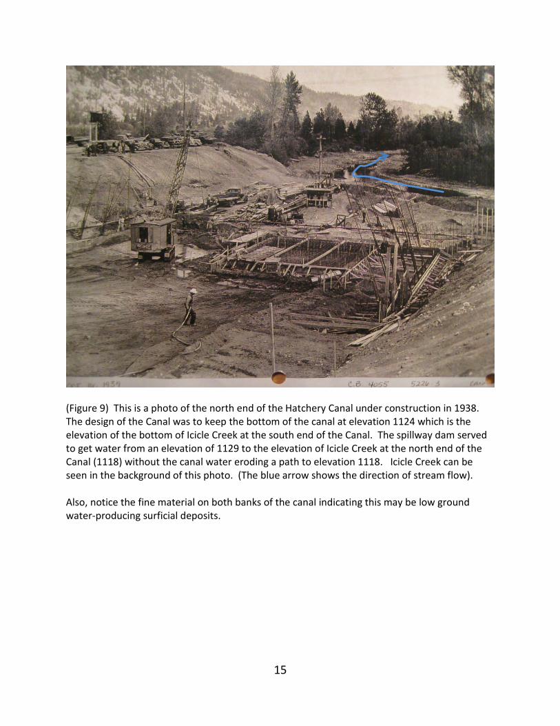
(Figure 9) This is a photo of the north end of the Hatchery Canal under construction in 1938. The design of the Canal was to keep the bottom of the canal at elevation 1124 which is the elevation of the bottom of Icicle Creek at the south end of the Canal. The spillway dam served to get water from an elevation of 1129 to the elevation of Icicle Creek at the north end of the Canal (1118) without the canal water eroding a path to elevation 1118. Icicle Creek can be seen in the background of this photo. (The blue arrow shows the direction of stream flow). Also, notice the fine material on both banks of the canal indicating this may be low ground water-producing surficial deposits.
16
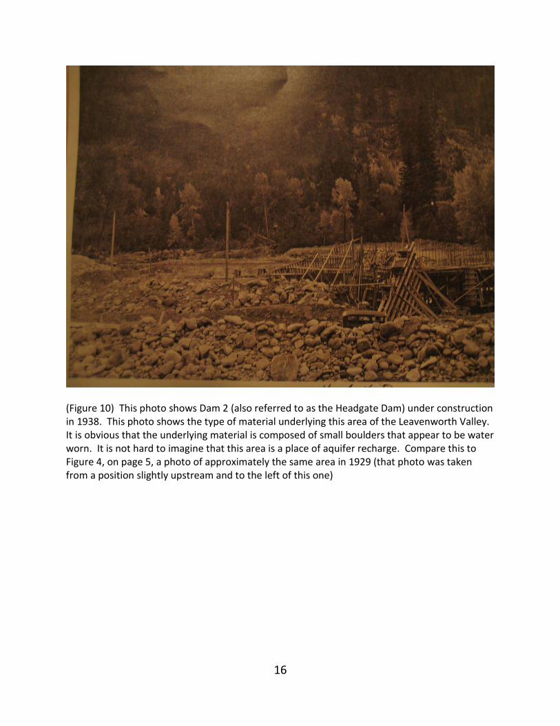
(Figure 10) This photo shows Dam 2 (also referred to as the Headgate Dam) under construction in 1938. This photo shows the type of material underlying this area of the Leavenworth Valley. It is obvious that the underlying material is composed of small boulders that appear to be water worn. It is not hard to imagine that this area is a place of aquifer recharge. Compare this to Figure 4, on page 5, a photo of approximately the same area in 1929 (that photo was taken from a position slightly upstream and to the left of this one)
17
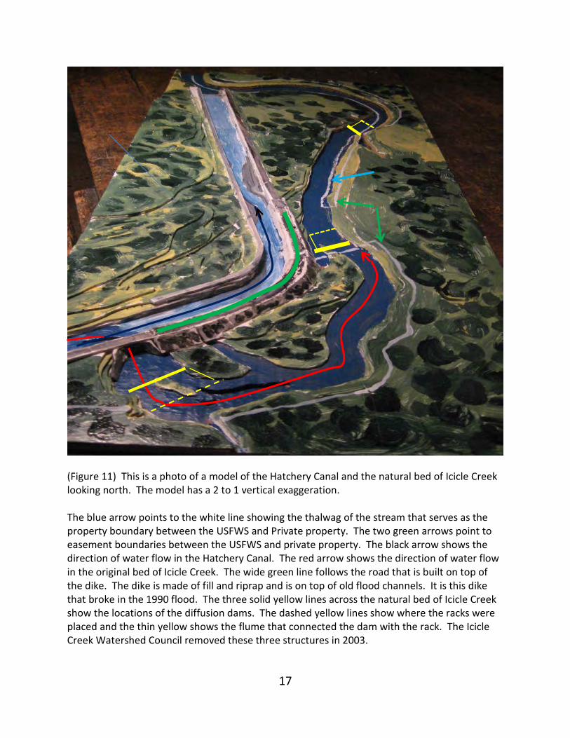
(Figure 11) This is a photo of a model of the Hatchery Canal and the natural bed of Icicle Creek looking north. The model has a 2 to 1 vertical exaggeration. The blue arrow points to the white line showing the thalwag of the stream that serves as the property boundary between the USFWS and Private property. The two green arrows point to easement boundaries between the USFWS and private property. The black arrow shows the direction of water flow in the Hatchery Canal. The red arrow shows the direction of water flow in the original bed of Icicle Creek. The wide green line follows the road that is built on top of the dike. The dike is made of fill and riprap and is on top of old flood channels. It is this dike that broke in the 1990 flood. The three solid yellow lines across the natural bed of Icicle Creek show the locations of the diffusion dams. The dashed yellow lines show where the racks were placed and the thin yellow shows the flume that connected the dam with the rack. The Icicle Creek Watershed Council removed these three structures in 2003.
18
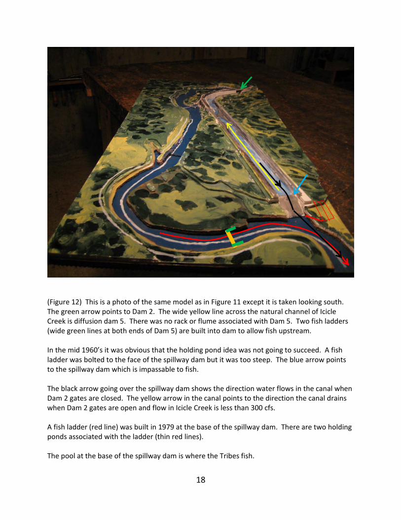
(Figure 12) This is a photo of the same model as in Figure 11 except it is taken looking south. The green arrow points to Dam 2. The wide yellow line across the natural channel of Icicle Creek is diffusion dam 5. There was no rack or flume associated with Dam 5. Two fish ladders (wide green lines at both ends of Dam 5) are built into dam to allow fish upstream. In the mid 1960’s it was obvious that the holding pond idea was not going to succeed. A fish ladder was bolted to the face of the spillway dam but it was too steep. The blue arrow points to the spillway dam which is impassable to fish. The black arrow going over the spillway dam shows the direction water flows in the canal when Dam 2 gates are closed. The yellow arrow in the canal points to the direction the canal drains when Dam 2 gates are open and flow in Icicle Creek is less than 300 cfs. A fish ladder (red line) was built in 1979 at the base of the spillway dam. There are two holding ponds associated with the ladder (thin red lines). The pool at the base of the spillway dam is where the Tribes fish.
19
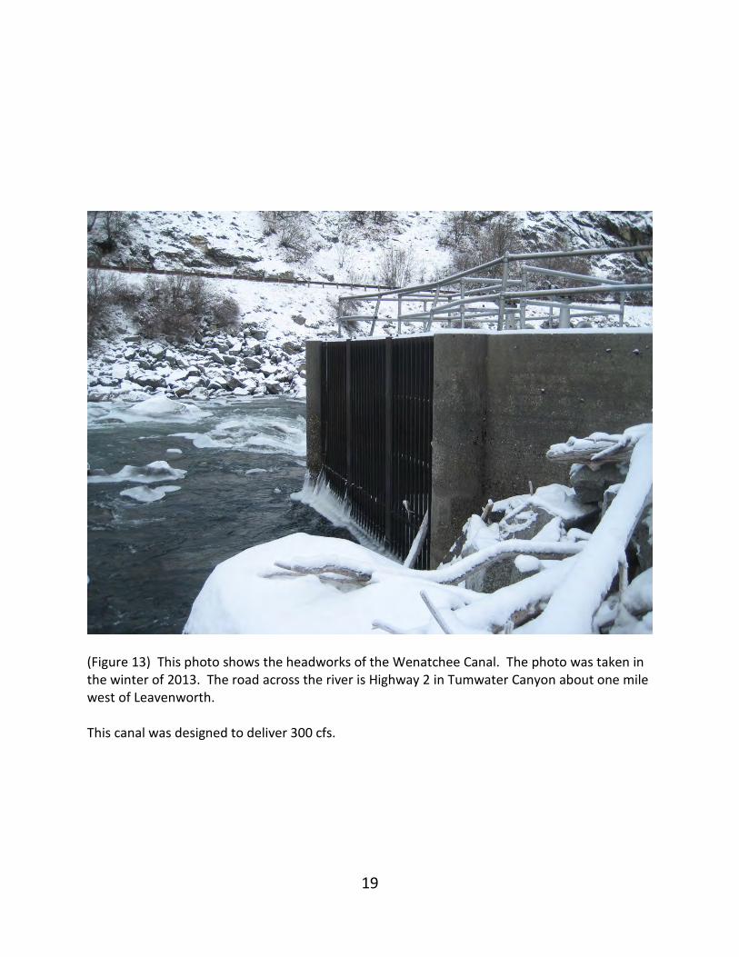
(Figure 13) This photo shows the headworks of the Wenatchee Canal. The photo was taken in the winter of 2013. The road across the river is Highway 2 in Tumwater Canyon about one mile west of Leavenworth. This canal was designed to deliver 300 cfs.
20
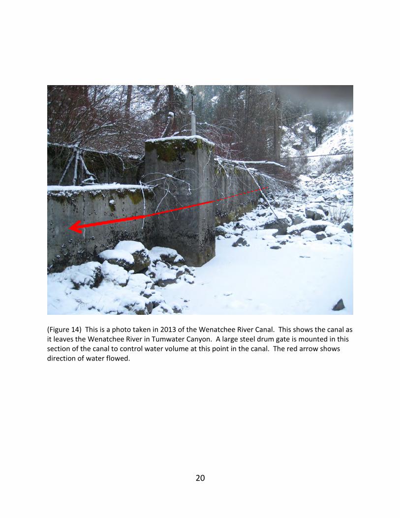
(Figure 14) This is a photo taken in 2013 of the Wenatchee River Canal. This shows the canal as it leaves the Wenatchee River in Tumwater Canyon. A large steel drum gate is mounted in this section of the canal to control water volume at this point in the canal. The red arrow shows direction of water flowed.
21
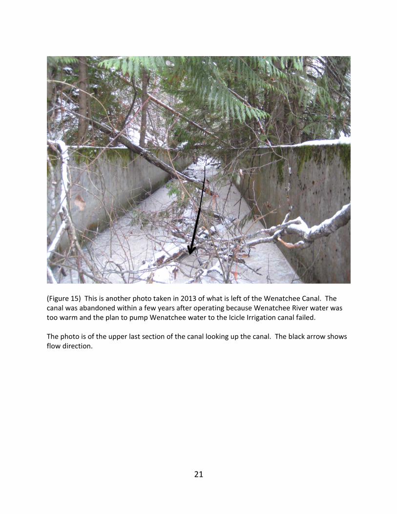
(Figure 15) This is another photo taken in 2013 of what is left of the Wenatchee Canal. The canal was abandoned within a few years after operating because Wenatchee River water was too warm and the plan to pump Wenatchee water to the Icicle Irrigation canal failed. The photo is of the upper last section of the canal looking up the canal. The black arrow shows flow direction.
22
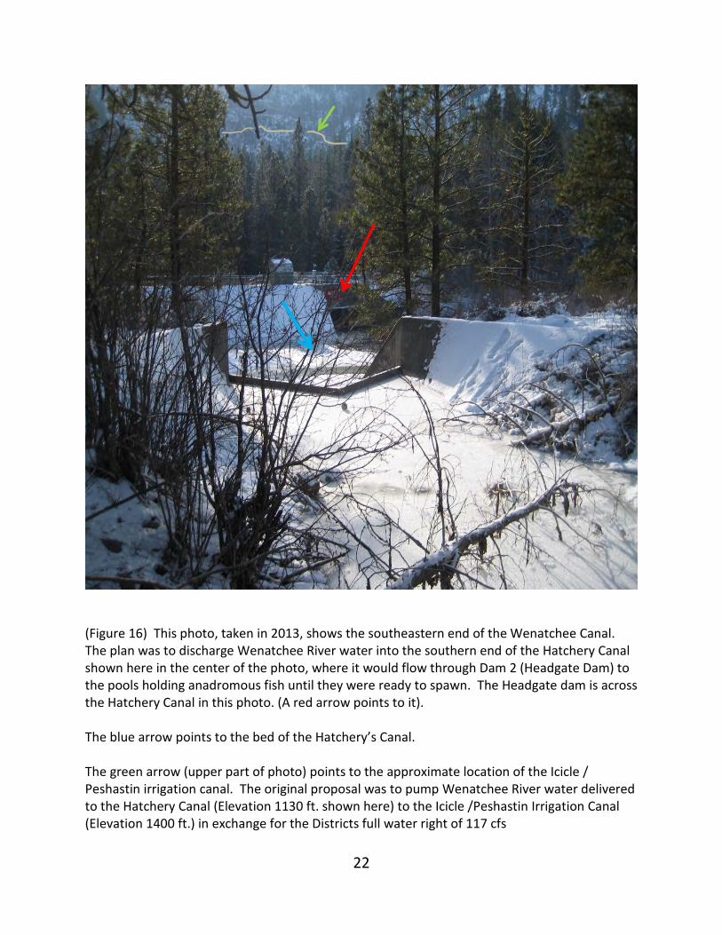
(Figure 16) This photo, taken in 2013, shows the southeastern end of the Wenatchee Canal. The plan was to discharge Wenatchee River water into the southern end of the Hatchery Canal shown here in the center of the photo, where it would flow through Dam 2 (Headgate Dam) to the pools holding anadromous fish until they were ready to spawn. The Headgate dam is across the Hatchery Canal in this photo. (A red arrow points to it). The blue arrow points to the bed of the Hatchery’s Canal. The green arrow (upper part of photo) points to the approximate location of the Icicle / Peshastin irrigation canal. The original proposal was to pump Wenatchee River water delivered to the Hatchery Canal (Elevation 1130 ft. shown here) to the Icicle /Peshastin Irrigation Canal (Elevation 1400 ft.) in exchange for the Districts full water right of 117 cfs
23
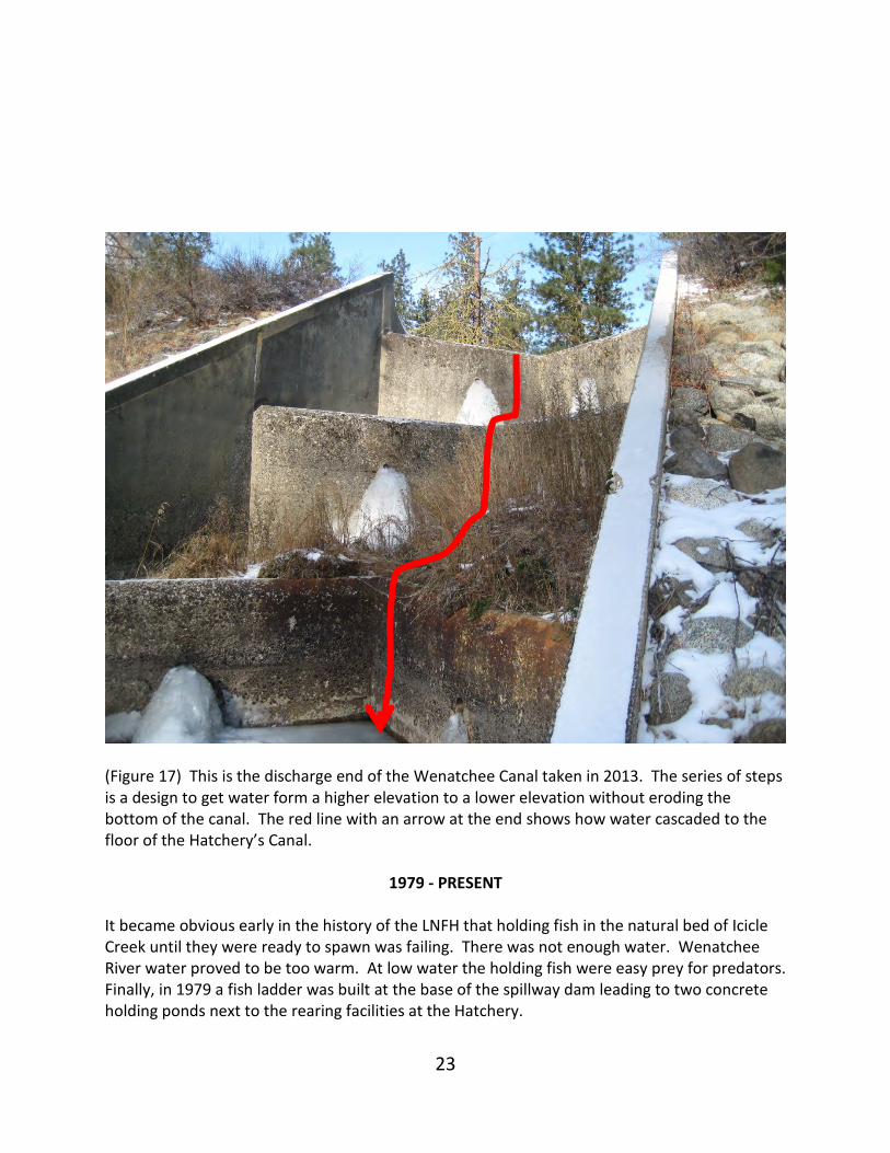
(Figure 17) This is the discharge end of the Wenatchee Canal taken in 2013. The series of steps is a design to get water form a higher elevation to a lower elevation without eroding the bottom of the canal. The red line with an arrow at the end shows how water cascaded to the floor of the Hatchery’s Canal.
1979 - PRESENT It became obvious early in the history of the LNFH that holding fish in the natural bed of Icicle Creek until they were ready to spawn was failing. There was not enough water. Wenatchee River water proved to be too warm. At low water the holding fish were easy prey for predators. Finally, in 1979 a fish ladder was built at the base of the spillway dam leading to two concrete holding ponds next to the rearing facilities at the Hatchery.
24
The holding ponds in the natural bed of Icicle Creek were abandoned. The gates of the control dam (Dam 2) were left closed diverting all of Icicle Creek into the Hatchery’s Canal, over the spillway dam at the north end of the Canal where it reconnected with the natural channel of Icicle Creek at River Mile 2.8. The boards of the four holding pool diffusion dams were left in place to impound small amounts of water that entered the natural bed from a small tributary stream (Mountain Home Creek). Leakage from water in the Hatchery’s Canal and leakage past the gates at Dam two were also sources of small amounts of water in the natural channel of Icicle Creek. In 1990, a 500 year flood consisting of approximately 20,000 cfs in Icicle Creek broke the dike at the bend in the southern end of the Hatchery Canal. The force of the water broke through the heavy timbers at each diffusion dam and damaged the steel holding rack at diffusion dam 4. After the floodwaters subsided, the ponds behind the diffusion dams drained leaving behind three to four feet of fine sediment deposits. Because Dam 2 gates remained closed, vegetation quickly took root in the sediments transforming the natural bed of Icicle Creek into a wetland. By 2001 the natural bed of Icicle Creek had undergone “reliction”, a process when dry land is formed by the withdrawal of water from, in this case, the shores of Icicle Creek, changing it to a waterless relic. The three following photos show what the natural channel of Icicle Creek looked like in 2001.
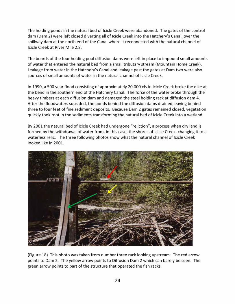
(Figure 18) This photo was taken from number three rack looking upstream. The red arrow points to Dam 2. The yellow arrow points to Diffusion Dam 2 which can barely be seen. The green arrow points to part of the structure that operated the fish racks.
25
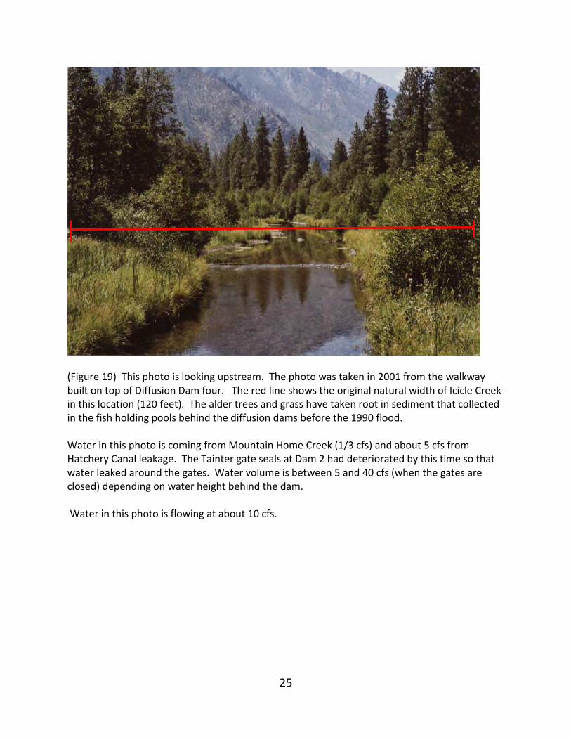
(Figure 19) This photo is looking upstream. The photo was taken in 2001 from the walkway built on top of Diffusion Dam four. The red line shows the original natural width of Icicle Creek in this location (120 feet). The alder trees and grass have taken root in sediment that collected in the fish holding pools behind the diffusion dams before the 1990 flood. Water in this photo is coming from Mountain Home Creek (1/3 cfs) and about 5 cfs from Hatchery Canal leakage. The Tainter gate seals at Dam 2 had deteriorated by this time so that water leaked around the gates. Water volume is between 5 and 40 cfs (when the gates are closed) depending on water height behind the dam. Water in this photo is flowing at about 10 cfs.
26
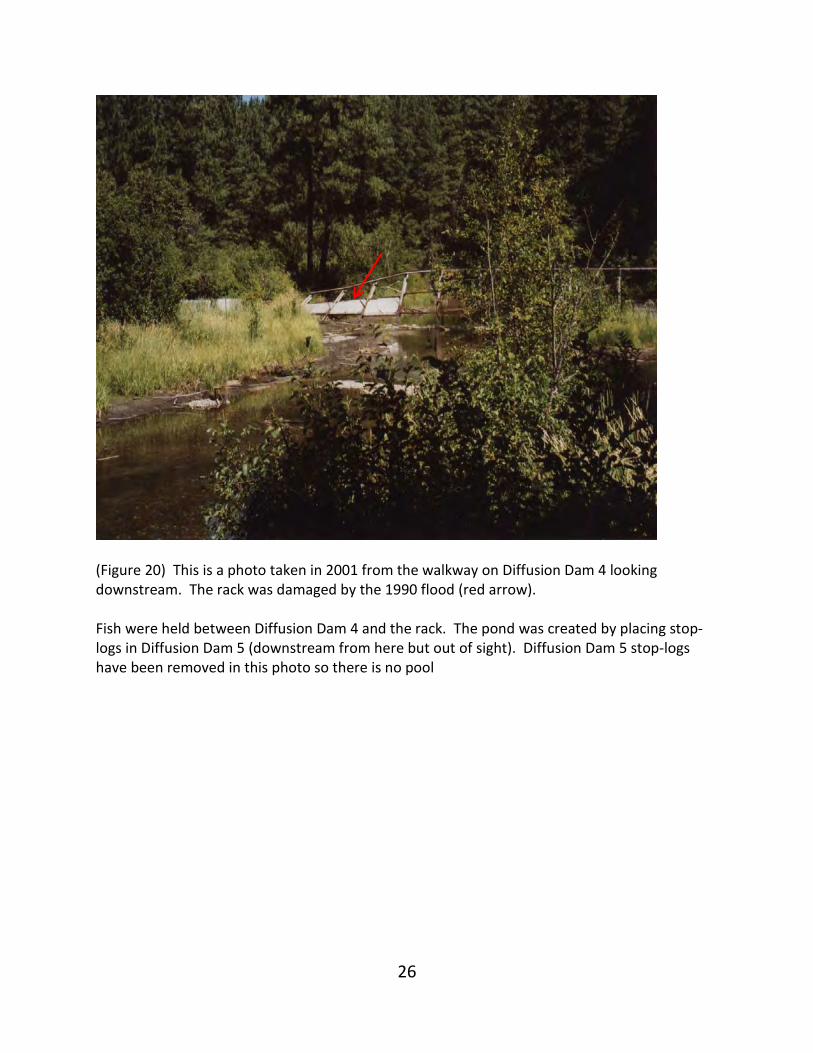
(Figure 20) This is a photo taken in 2001 from the walkway on Diffusion Dam 4 looking downstream. The rack was damaged by the 1990 flood (red arrow). Fish were held between Diffusion Dam 4 and the rack. The pond was created by placing stop-logs in Diffusion Dam 5 (downstream from here but out of sight). Diffusion Dam 5 stop-logs have been removed in this photo so there is no pool
27
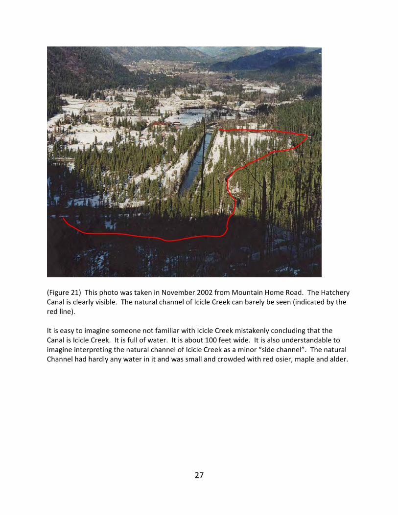
(Figure 21) This photo was taken in November 2002 from Mountain Home Road. The Hatchery Canal is clearly visible. The natural channel of Icicle Creek can barely be seen (indicated by the red line). It is easy to imagine someone not familiar with Icicle Creek mistakenly concluding that the Canal is Icicle Creek. It is full of water. It is about 100 feet wide. It is also understandable to imagine interpreting the natural channel of Icicle Creek as a minor “side channel”. The natural Channel had hardly any water in it and was small and crowded with red osier, maple and alder.
28
ICICLE CREEK WATER PERMITS
& RELINQUISHMENTS
The federal government obtained a water right of 200 cfs from Icicle Creek from the State in 1942. The water would be used to water the holding ponds in the natural bed of Icicle Creek and in the Hatchery where eggs were incubated and fish were subsequently reared. It is reasonable to assume that this was done to protect the Hatchery’s operation from an upstream diverter; if the federal government did not reserve this 200 cfs through a water right, an upstream diverter could theoretically dry up the stream. A water right of 300 cfs from the Wenatchee River in Tumwater Canyon was obtained from the State to supply additional water to the holding ponds in the natural bed of Icicle Creek when Icicle Creek water volumes were low. A water right of 16,000 acre-feet was obtained from the State with a permit to drill a tunnel through a granite ridge to the bottom of Snow Lakes and use the lakes as a reservoir. The Snow Lakes reservoir was permitted to supply the Hatchery with additional water. The first water right relinquished was the 300 cfs from the Wenatchee River. The proposal to pump Wenatchee River water to the Icicle Irrigation Canal District in exchange for the District’s Icicle Creek water did not materialize. Without the exchange of water with the Irrigation District, the Wenatchee River water permit was useless because Wenatchee River water could not be used due to its high temperatures. By the mid 1960’s, the Wenatchee Canal was demolished except for the upper three-fourths mile and the lower one mile. The relinquished water was returned to public waters in the Wenatchee River where it could be put to a beneficial use if the need arose. In 1984 a partial relinquishment of 158 cfs from the 200 cfs obtained in 1942 was returned to the State because it was no longer being put to a beneficial use. The holding ponds in the natural bed of Icicle Creek had been abandoned. The remaining 42 cfs remained with the USFWS for use in the Hatchery because it was beneficially used (not all of the year, but for most of the year when it was available). The 1942 permitted 200 cfs water right existed only in part. The reason the Wenatchee Canal was built was because it was recognized that Icicle Creek could not meet the full 200 cfs required by the Hatchery and holding ponds. An analysis of Icicle Creek flow records reveals that only in April, May, June and July could the water right of 200 cfs have been met continuously by Icicle Creek. In 2003, three of the holding pond structures, including the associated racks, flumes and spawning sheds, were removed by the Icicle Creek Watershed Council using private funding. The Council assumed the USFWS considered the natural bed of Icicle as the main channel of the
29
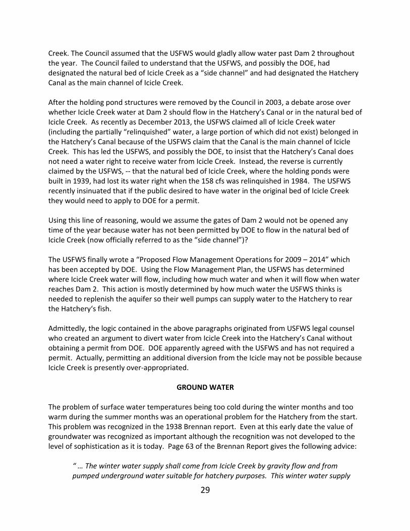
Creek. The Council assumed that the USFWS would gladly allow water past Dam 2 throughout the year. The Council failed to understand that the USFWS, and possibly the DOE, had designated the natural bed of Icicle Creek as a “side channel” and had designated the Hatchery Canal as the main channel of Icicle Creek. After the holding pond structures were removed by the Council in 2003, a debate arose over whether Icicle Creek water at Dam 2 should flow in the Hatchery’s Canal or in the natural bed of Icicle Creek. As recently as December 2013, the USFWS claimed all of Icicle Creek water (including the partially “relinquished” water, a large portion of which did not exist) belonged in the Hatchery’s Canal because of the USFWS claim that the Canal is the main channel of Icicle Creek. This has led the USFWS, and possibly the DOE, to insist that the Hatchery’s Canal does not need a water right to receive water from Icicle Creek. Instead, the reverse is currently claimed by the USFWS, -- that the natural bed of Icicle Creek, where the holding ponds were built in 1939, had lost its water right when the 158 cfs was relinquished in 1984. The USFWS recently insinuated that if the public desired to have water in the original bed of Icicle Creek they would need to apply to DOE for a permit. Using this line of reasoning, would we assume the gates of Dam 2 would not be opened any time of the year because water has not been permitted by DOE to flow in the natural bed of Icicle Creek (now officially referred to as the “side channel”)? The USFWS finally wrote a “Proposed Flow Management Operations for 2009 – 2014” which has been accepted by DOE. Using the Flow Management Plan, the USFWS has determined where Icicle Creek water will flow, including how much water and when it will flow when water reaches Dam 2. This action is mostly determined by how much water the USFWS thinks is needed to replenish the aquifer so their well pumps can supply water to the Hatchery to rear the Hatchery‘s fish. Admittedly, the logic contained in the above paragraphs originated from USFWS legal counsel who created an argument to divert water from Icicle Creek into the Hatchery’s Canal without obtaining a permit from DOE. DOE apparently agreed with the USFWS and has not required a permit. Actually, permitting an additional diversion from the Icicle may not be possible because Icicle Creek is presently over-appropriated.
GROUND WATER The problem of surface water temperatures being too cold during the winter months and too warm during the summer months was an operational problem for the Hatchery from the start. This problem was recognized in the 1938 Brennan report. Even at this early date the value of groundwater was recognized as important although the recognition was not developed to the level of sophistication as it is today. Page 63 of the Brennan Report gives the following advice:
“ … The winter water supply shall come from Icicle Creek by gravity flow and from pumped underground water suitable for hatchery purposes. This winter water supply
30
shall provide a minimum of 8,240 gpm (for hatchery troughs, feeding tanks and winter rearing ponds). A 10 percent additional flow shall be pumped underground water (for tempering the Icicle water). …”
In 1995 GeoEngineers conducted a study of the aquifer underlying Leavenworth National Hatchery’s property. GeoEngineers concluded that:
“Our evaluation of surface water elevations, flow rates and location of the surface water features with respect to the hatchery production wells indicate that Icicle Channel (Hatchery Canal) and Icicle Creek (the natural bed of Icicle Creek) are significant sources of recharge to the shallow aquifer…”
The Hatchery’s well pumps have the capacity to extract ground water at greater rates then are naturally produced in automatic pump shutdowns as a pump protection measure. Hatchery well pumps have the capacity to pump the aquifer to a level close to exhaustion. Exhausting the aquifer has led to the practice, by the USFWS, of resupplying the aquifer with Icicle Creek water by closing the gates of Dam 2 thus diverting Icicle Creek water into the Hatchery Canal. The Hatchery Canal runs directly over the well-field on relatively porous surficial deposits resulting in water percolating into the aquifer at relatively high transmissivity rates. Using Icicle Creek surface water to recharge the well field takes place several times each year between September and March with each water injection lasting between two to three weeks. When the injection is complete there is enough water stored in the aquifer to supply the Hatchery with ground water for about six weeks. As already mentioned, the USFWS and possibility the Department of Ecology have designated the Hatchery Canal as Icicle Creek and describe the original bed of Icicle Creek, (where the fish holding ponds were built in 1938), as the “side channel” assigning it to minor channel status of Icicle Creek. The USFWS determines when to open the gates of Dam 2 and when to close them with the highest priority serving the needs of the Hatchery first and the needs of the natural bed of Icicle second – although, as explained above, the USFWS does not have a water right to divert Icicle Creek into the natural bed. The need for groundwater beyond the natural productivity of the aquifer has led to exceptionally strong resistance by the USFWS to allow fish passage past the Leavenworth National Fish Hatchery. The Hatchery’s need to recharge the aquifer with water stops all fish migration. Fish are unable to migrate past the hatchery using the natural bed of Icicle Creek when Dam 2 gates are closed. All water is diverted into the Canal. Migrating fish cannot migrate using the canal because the spillway dam at the north end of the canal is a solid cement barrier to all fish movement year around. Over the past 10 years water flow in Icicle Creek has been adequate during late summer and early fall so that the Hatchery has not had to completely close the gates of Dam 2 as has been
31
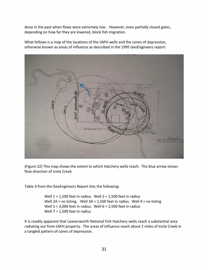
done in the past when flows were extremely low. However, even partially closed gates, depending on how far they are lowered, block fish migration. What follows is a map of the locations of the LNFH wells and the cones of depression, otherwise known as areas of influence as described in the 1995 GeoEngineers report:
(Figure 22) This map shows the extent to which Hatchery wells reach. The blue arrow shows flow direction of Icicle Creek. Table 3 from the GeoEngineers Report lists the following:
Well 1 = 1,500 feet in radius. Well 2 = 1,500 feet in radius Well 2A = no listing. Well 3A = 1,500 feet in radius. Well 4 = no listing Well 5 = 3,000 feet in radius. Well 6 = 2,500 feet in radius Well 7 = 1,500 feet in radius
It is readily apparent that Leavenworth National Fish Hatchery wells reach a substantial area radiating out from LNFH property. The areas of influence reach about 2 miles of Icicle Creek in a tangled pattern of cones of depression.
32
In 1945, the Legislature enacted a comprehensive ground water code to regulate and control allocation of public ground water. The legislature adopted the prior appropriation principles of the surface water code and applied them to ground water. Ground water rights are limited by a concept of feasibility and reasonableness in light of the characteristics of the aquifer being tapped. The Washington Revised Code 90.44.070 provides in part:
“No permit shall be granted for the development or withdrawal of public ground waters beyond the capacity of the underground bed or formation in the given basin district, or locality to yield such water within a reasonable or feasible pumping lift in case of pumping developments, or within a reasonable or feasible reduction of pressure in the case of artesian developments.”
When issuing groundwater rights to the USFWS for the Leavenworth Fish Hatchery, the State permitted more water in the 1980’s than the aquifer produces on a continual basis. The ground water permits issued to the LNFH should have been based on reasonable or feasible pumping lift as provided for in Wash. Ref. code 90.44.070 instead of volume (in Leavenworth’s case, 6700 gallons per minute). In ground water appropriation debates the issues generally involve a right to a given pressure level rather than a simple right to an amount of water. The purpose of code 90.44.130 is to prohibit overdraft or “mining” of ground water resources – that is, where the depletion of an aquifer occurs at a rate faster than the natural rate of recharge. But overdrafting is exactly what is occurring here and is the fundamental reason why the Hatchery needs to artificially recharge the aquifer by closing the gates of Dam 2 so that Icicle Creek is diverted into the Hatchery’s canal. The Leavenworth National Fish Hatchery keeps the gates of Dam 2 closed until the aquifer is fully charged. When the gates of Dam 2 are reopened the Canal will drain southward into Icicle Creek if Icicle Creek flows are below 300 cfs at Dam 2. If Icicle Creek water flows remain below 300 cfs during this time, Dam 2 gates will again be closed to divert water into the Hatchery’s Canal to recharge the aquifer. The opening and closing of Dam 2 signals to observers that the Hatchery Canal is a canal and that water diverted into the canal is artificial. Yet, the USFWS insists that the Hatchery Canal is Icicle Creek and therefore natural and therefore does not require a water right.
33
CHELAN COUNTY’S SHORELINE MASTER PROGRAM UPDATE One reason for confusion between the status of the natural bed of Icicle Creek and the Hatchery‘s Canal might have originated from Chelan County’s Shoreline Management Plan (SMP).
(Figure 23) This is a photo of an enlargement of a map form Appendix A of Chelan County’s Shoreline Master Program Update August 31, 2010. In this plan, shoreline jurisdiction boundaries are delineated by drawing red lines on maps around waters of statewide significance in Appendix A of the SMP. When these lines were drawn for Icicle Creek the lines spread apart at the intersection of the canal and the natural bed of Icicle Creek at Dam 2 to include both the natural bed and the Hatchery Canal (Figure 23). One jurisdiction line follows the west side of the Hatchery’s Canal and the other jurisdiction line follows the easement boundary between USFWS and private property on the southeast bank of the natural bed of Icicle Creek. The two lines finally return to following the east and west banks of Icicle Creek below the spillway dam at the north end of the Hatchery’s Canal (Figure 23). Since 2000 the question has been; which channel is the dominant channel -- which channel is
34
subordinate – which channel needs a water right or does neither channel need a water right? The act of opening and closing the gates at Dam 2 begs for clear guidance. The major written document guiding the use of water at Dam 2 is the, “Leavenworth National Fish Hatchery Proposed Flow Management Operations for 2009 – 2014”. This document was written by the USFWS and essentially outlines how the USFWS plans to manage Icicle Creek water at Dam two. APPENDIX A of the 1975 SMP contains the Environment designations and jurisdictional Boundary Descriptions which were not changed for Icicle Creek in the last 2010 SMP Update. The introduction to the 1975 APPENDIX A states the following:
“The following notations describe the Environment designations and boundary locations for shorelines covered by the Shorelines Management Act of 1971 in Chelan County. The shoreline locations, beginning with Section, Township, and Range refer to Environment boundary lines, and the term Urban, Rural, Conservancy and Natural, which appear between successive boundary descriptions, refer to the appropriate Environment designations for that portion of the shoreline. In the case of rivers and streams the descriptions begin with the farthest downstream point and progress upstream. In the case of Lake Chelan and Lake Wenatchee, the descriptions begin at the outlet and progress up lake to the inlet. Simple descriptions cover the smaller lakes. In the upper reaches of several drainages, National Forest and non-federal ownerships are often intermixed. In such cases, the furthest point of non-federal ownership is listed as the Environment boundary; however the included federal portions are excluded from the provisions of the Act.” (Emphasis added)
In the 1975 SMP and in the 2010 SMP Icicle Creek the shoreline jurisdiction boundary is identified: “9. Icicle Creek
a. Northwest Shoreline S. 13, T. 24N, R. 17E – Confluence with Wenatchee River Conservancy S. 05, T. 24N, R. 16E – All property excluding federal ownership
b. Southeast Shoreline S. 13, T. 24N, R. 17E – Confluence with Wenatchee River Conservancy S. 05, T. 24N, R. 16E – All property excluding federal ownership” S. 13, T. 24N; R. 17E is located at River Mile 16.3 close to the Chatter Creek USFS Guard Station. From RM 16.3, downstream, parcels of private land are comingled with USFS property. Icicle Creek enters federal land (approximately 157 acres and owned by the USFWS) at Rm 3.8. The entire southeast and east bank of Icicle Creek is owned privately. The private property owners are subject to the laws contained within Chelan County’s Shoreline Master Program. However, both banks of the Hatchery Canal are on USFWS property. By definition, the Hatchery Canal is excluded from the provisions of the Shoreline Management Act.
35
It is easy to recognize the potential for confusion here. Icicle Creek is a shoreline of Statewide Significance because by the time Icicle Creek reaches the Leavenworth National Fish Hatchery; the annual flow is measured at more than 200 cfs and drains an area greater than 300 square miles. (Chelan County Master Program August 31, 2010 3.4 Shorelines of Statewide significance 3.4.1 Designation Criteria):
“In Chelan County, shorelines of statewide significance include those lakes, whether natural, artificial, or a combination thereof, with a surface area greater than or equal to 1,000 acres measured from the [ordinary high water mark] OHWM, and natural rivers or segments thereof downstream of a point where the annual flow is measured at two hundred (200) cubic feet per second or more, or those portions of rivers east downstream from the first three hundred (300) square miles of drainage area, whichever is longer. (Bold face emphasis is mine)
This ¼ mile widening of the shoreline jurisdiction boundaries includes an unusual combination of a natural path for water (the original bed of Icicle Creek) bordered by private property on the east shore making it subject to the provisions of the SMP and an artificial path (the Hatchery Canal) owned completely by the federal government which is excluded from the provisions of the SMP. When Dam 2 is opened the canal drains dry. However, the canal is referred to as Icicle Creek by the USFWS and, according to the jurisdiction boundary, is designated as a shoreline of Statewide Significance. When Dam 2 gates are closed, water in the natural bed of Icicle Creek is completely cut off in low flow years. However, the natural bed of Icicle Creek remains designated as a Shoreline of Statewide Significance. The southeast and east shore of Icicle Creek is private property and therefore is subject to the provisions of the SMA. The proposal describing the Hatchery Canal as the main braid of Icicle Creek does not make sense when the history of the Hatchery Canal is understood. The Hatchery’s canal is no different from hundreds of canals in Eastern Washington that divert water and put it to beneficial use. None of these canals are referred to as a braid let alone the main braid of the stream from which they divert water. When water arrives at the Icicle/Peshastin Canal, judicial boundaries do not follow the east and southeast shore of the irrigation canal. Instead, the boundary continues to follow the southeast and south shoreline of Icicle Creek.
36
ENVIRONMENT DESIGNATIONS
The Chelan County Shoreline Master Program complies with WAC 173-26-211 by producing maps of streams and lakes showing “Environment Designations” for reaches of shorelines of statewide significance. Four designations are used (Natural, Conservancy, Rural, and Urban). Section 9 of the Draft Chelan County Shoreline Master Program defines the four designations as follows: Natural, shown as green on the maps is defined as:
“The purpose of the “Natural” environment is to protect those shoreline areas that are relatively free of human influence or that include intact or minimally degraded shoreline functions intolerant of human use. These systems require that only very low-intensity uses be allowed in order to maintain the ecological functions and ecosystem-wide processes. Degraded shoreline areas within this environment should be planned for restoration.”
Conservancy, shown as yellow on the maps is defined as:
“The purpose of the “Conservancy” environment is to retain shoreline ecological functions, and processes by avoiding forms of development that would be incompatible with existing functions and processes, conserve existing natural resources and valuable historic and cultural areas in order to provide for sustained resources use, achieve natural floodplain processes, and provide low-intensity recreational opportunities. Within the Conservancy environment, the overall intensity of development and use should remain low, thereby maintaining most of the area’s natural character.
Rural, shown as orange on the maps is defined as:
“The purpose of the “Rural” environment is to protect shoreline ecological functions in areas having a rural character characterized by open space and low-density development including, but not limited to: residences, agriculture, and active outdoor recreation. Uses should be compatible with the physical capabilities and limitations, natural resources, and shoreline ecological functions and processes of the area”.
Urban, shown as red on the maps is defined as:
“The purpose of the “Urban” environment is to accommodate a range and mixture of residential, and water-oriented commercial and institutional uses at moderate intensity and density levels, while protecting existing ecological functions and restoring ecological functions in areas that have been previously degraded. Water-dependent utilities and industrial uses are also
37
accommodated. In addition, this designation provides for appropriate physical and visual public access and recreation uses”.
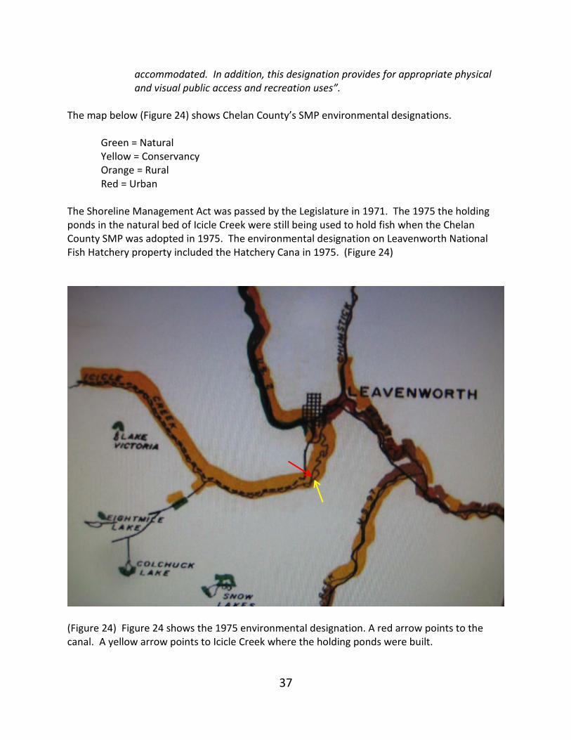
The map below (Figure 24) shows Chelan County’s SMP environmental designations. Green = Natural Yellow = Conservancy
Orange = Rural Red = Urban The Shoreline Management Act was passed by the Legislature in 1971. The 1975 the holding ponds in the natural bed of Icicle Creek were still being used to hold fish when the Chelan County SMP was adopted in 1975. The environmental designation on Leavenworth National Fish Hatchery property included the Hatchery Cana in 1975. (Figure 24)
(Figure 24) Figure 24 shows the 1975 environmental designation. A red arrow points to the canal. A yellow arrow points to Icicle Creek where the holding ponds were built.
38
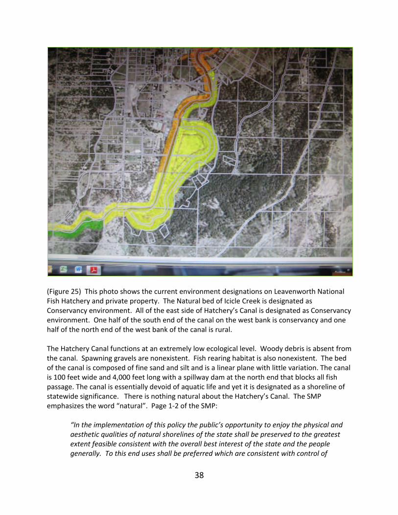
(Figure 25) This photo shows the current environment designations on Leavenworth National Fish Hatchery and private property. The Natural bed of Icicle Creek is designated as Conservancy environment. All of the east side of Hatchery’s Canal is designated as Conservancy environment. One half of the south end of the canal on the west bank is conservancy and one half of the north end of the west bank of the canal is rural. The Hatchery Canal functions at an extremely low ecological level. Woody debris is absent from the canal. Spawning gravels are nonexistent. Fish rearing habitat is also nonexistent. The bed of the canal is composed of fine sand and silt and is a linear plane with little variation. The canal is 100 feet wide and 4,000 feet long with a spillway dam at the north end that blocks all fish passage. The canal is essentially devoid of aquatic life and yet it is designated as a shoreline of statewide significance. There is nothing natural about the Hatchery’s Canal. The SMP emphasizes the word “natural”. Page 1-2 of the SMP:
“In the implementation of this policy the public’s opportunity to enjoy the physical and aesthetic qualities of natural shorelines of the state shall be preserved to the greatest extent feasible consistent with the overall best interest of the state and the people generally. To this end uses shall be preferred which are consistent with control of
39
pollution and prevention of damage to the natural environment, or are unique to or dependent upon use of the state’s shoreline.”
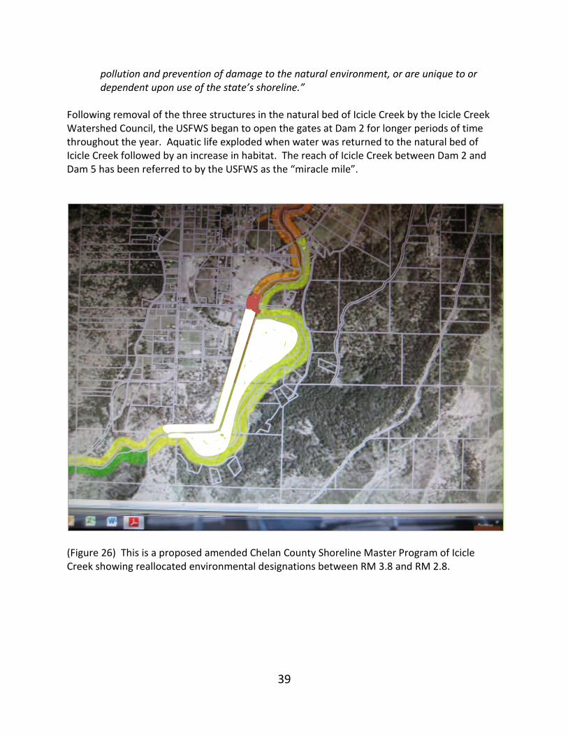
Following removal of the three structures in the natural bed of Icicle Creek by the Icicle Creek Watershed Council, the USFWS began to open the gates at Dam 2 for longer periods of time throughout the year. Aquatic life exploded when water was returned to the natural bed of Icicle Creek followed by an increase in habitat. The reach of Icicle Creek between Dam 2 and Dam 5 has been referred to by the USFWS as the “miracle mile”.
(Figure 26) This is a proposed amended Chelan County Shoreline Master Program of Icicle Creek showing reallocated environmental designations between RM 3.8 and RM 2.8.
40
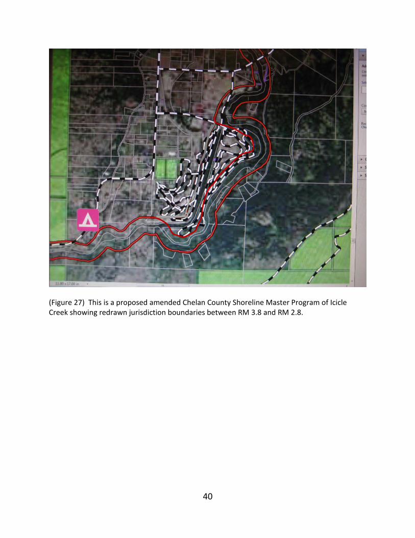
(Figure 27) This is a proposed amended Chelan County Shoreline Master Program of Icicle Creek showing redrawn jurisdiction boundaries between RM 3.8 and RM 2.8.
41
SUMMARY From a physical perspective, it is obvious that the Hatchery Canal never was Icicle Creek and is not Icicle Creek today. Although it can be accurately said that the extreme western portion of the canal occupies the bed of Icicle Creek for about 200 feet and flows across historic flood channels of Icicle Creek for another 300 feet. The purpose for constructing Dam 2 across the main channel of Icicle Creek in 1938 was to control water into the holding ponds built in the natural bed of Icicle Creek by diverting flows greater than 200 cfs into the Canal. (A stilling well was drilled next to Diffusion Dam 2 to give electrical signals to raise or lower Dam 2 gates when the pool water level behind Diffusion Dam 2 changed.) A water right of 200 cfs was obtained in 1942 to assure that the federal government would have enough water for fish being held in the holding ponds located in the natural bed of Icicle Creek. However, it was clear that a large portion of the 200 cfs was simply not available during low flow months in most years. After a fish ladder was built in 1979, there was no longer a need to restrict flow to no more than 200 cfs in the reach of Icicle Creek containing the holding ponds. In 1984 a partial relinquishment of the 200 cfs (158 cfs) was relinquished back to the State. In 2003, the Icicle Creek Watershed Council obtained private funding to remove all three holding pond structures from the natural bed of Icicle Creek so that more water could be released into the original channel without unnecessary erosion that would otherwise occur. However, Dam 2 was still used to control flows in the natural bed of Icicle Creek when: (1) pickets were in place at Dam 5, (2) during floods, (3) to recharge the aquifer, (4) to flush Hatchery released smolts downstream, and (5) to maintain pool depth at the base of the spillway dam. Of the five operational actions listed above for Dam 2, only number, “(3) recharging the aquifer”, remains the operational action strongly opposed by stakeholders. The other actions have been discontinued or have been altered to satisfy stakeholder concerns. The need to recharge the aquifer occurs during low flow months and has led agencies and their legal counsel to insist the Hatchery‘s Canal is Icicle Creek and that the natural bed of Icicle Creek, where the holding ponds were built in 1938, lost the right to have Icicle Creek flow in it when the 158 cfs, referred to above, was relinquished in 1984. Insisting that the Hatchery’s Canal is the main stem of Icicle Creek and the natural bed of Icicle Creek is an ancillary channel of Icicle Creek sets the stage for the Hatchery’s Canal to legally receive all of Icicle Creek’s water during droughts, leaving the natural bed dry.
42
This line of reasoning, (concluding that the Hatchery’s Canal is Icicle Creek), likely has its origin in the 1971 Shoreline Management Act when, in 1975, Chelan County drew the environmental boundaries for Shorelines of “Statewide Significance” to include both the natural bed of Icicle Creek and the Hatchery’s Canal (See Figure 24). This same designation has carried forward to Chelan County’s SMP 2010 update (see Figure 23 and 25). The reason for focusing on the one-mile reach of Icicle Creek between RM 2.8 and RM 3.8, is that it is here where agreement, over the past 17 years, on how to distribute Icicle Creek water has failed. Over those 17 years, agreement has come surprisingly close. But it has slipped out of the grasp of negotiating participants because of the use of a particular word or phrase or implication that negatively influences trust. This fragile type of wariness is rooted in language – the use of words. Using words to describe the Hatchery’s Canal as Icicle Creek violates a sense of reality that generates distrust. Without trust, an agreement on how to distribute Icicle Creek water will continue to be illusive. Therefore, it seems important that the Hatchery‘s Canal be referred to as the Canal, not Icicle Creek, and that the natural bed of Icicle Creek cease to be referred to as the “side channel”. It is obvious that the Leavenworth National Fish Hatchery is too large for a small stream like Icicle Creek. It is too large for the small aquifer on which the LNFH depends. But this does not mean the Hatchery has to be downsized or dismantled in order to return the ecology of Icicle Creek to its original productivity. New water conservation technology is available that would relieve the stress on the Icicle and the aquifer. It is a matter of funding. Water conservation is the future to managing water in the West. Dick Rieman 01/12/14 Over the past 17 years I have spent approximately 15,000 hours studying the prospects of linking the upper 20 miles of Icicle Creek with the lower 4 miles. I have served on a long and varied list of committees. I have been a participant in studies ranging from collecting data on Icicle Creek invertebrate populations to fluvial geomorphological measurements, to collecting and studying historical stream flow data and fish populations of the Icicle. Most important has been my introduction to a wide variety of people dependent on Icicle Creek for their livelihood. In the past I have coordinated with federal and state agencies. Recently, the Icicle has entered a new and important phase with the inclusion of city and county government officials.

43

44