Embed Size (px)
Citation preview


BRICK SHALE RESOURCES OF CANBERRA
by
D.E. GARDNER
RECORDS 1960/1
'Page
,r_UMMARY^ 1INTRODUCTION^ 1GEOLOGY OF CANBERRA CITT DISTRICT WITH REFERENCE TO
BRICK SHALE^ 2INVESTIGATIONS OF DEPOSITS^ 21VINOR DEPOSITS^ 2
BLOCK 46, BELCONNEN DISTRICT^ 2BLOCK 28A, WODEN DISTRICT^ 3Cemetery Road Deposit^ 3Federal Deposit^ 3CANBERRA CITY DISTRICT^ 3Cork Hill^ 3'ETHERIDGE CREEK^ 4Mahon Hill^ 5
MAJOR DEPOSITS^ 5QUEANBEYAN^ 5NORTH OF CANBERRA^ 6General^ 6Gungaderra^ 7Crace Trig.^ 7Belconnen^ 9
LABORATORY TESTING OF BRICK SHALE^ 10REFERENCES^ 11
TABLES
1. Geological succession, Canberra District with referenceto brick shale deposits.
2. Brick shale resources of Canberra: Major deposits.3. Constituents, firing data, and properties of trial briquettes.
ILLUSTRATIONS
Plate 1 Geological map of portion of A.C.T. showing brick shalelocalities.
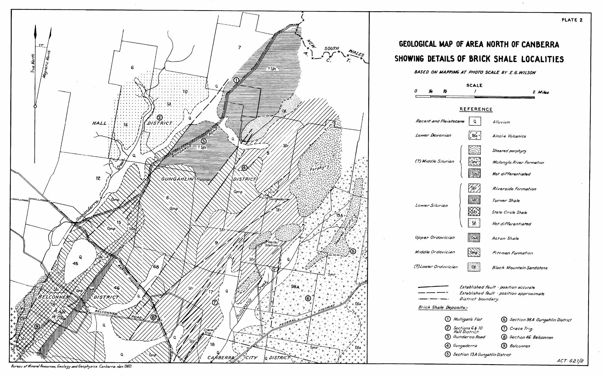
2 Geological map of area north of Canberra giving detailsof brick shale localities.
3 Geological map showing localities of Cemetery Road andFederal deposits.11^4 Cemetery Road deposit.
5 Federal Deposit.11^6 Cork Hill deposit.7 Etheridge Creek deposit.8 Queanbeyan deposit:9 Gungaderra deposit:
" 10 Grace Trig. deposit." 11 Belconnen deposit.
PPI7

BRICK SHALE RESOURCES OF CANBERRA
SUMMARY
Reference to the geological map of Canberra andsurrounding districts shows that important deposits of shalesuitable for brick making can be expected only in the C_a_nlizFraGroup of Lower Silurian sedimentary rocks and in shales in theClianbeyan area near the boundary between rocks of Upper Ordov-ician and Lower Silurian ages. The area south and west ofCanberra consists mainly of igneous rocks unsuitable for brick-making.
Sedimentary rocks of the Canberra Group underliemost of Canberra City, and during 1959 supplies of brickshale have been obtained from Cork Hill, near the site of thefuture permanent Parliament House. Except for this locality,where excavation has to be carried out to remove the crest ofthe hill, mining within the city boundary is not permitted.North of Canberra City very large reserves of brick shale havebeen proved. This material has not been shown to be suitablefor immediate use in the present Brickworks plant.
' In the Queanbeyan area north of Mt. Jerisbomberraa deposit of shale that has been mapped aad sampled could pro-vide supplies for the Brickworks for about 10 to 15 years. Theshale makes a very satisfactory,brick with the plant that isbeing operated at present.
INTRODUCTION
The Canberra brickworks was established at itspresent site at Yarralumla early in the history of Canberraadjacent to an outcropping body of calcareous shale and sandstone,in which a pit was started for the supply of brick shale. Upto the start of the war, 1939, when it had been nearly minedout, this pit had supplied raw material •for the manufacture ofabout 70,000,000 bricks. During war-time the brickworks closeddown and orders were met from accumulated stocks.
In anticipation of a heavy post-war demand for bricksthe need for a new deposit of shale became somewhat urgent.The Bureau of Mineral Resources (Nye and Owen, 1944) investigateda low hill at Deakin consisting of calcareous shale and tuffac-eous sandy beds, which had been recommended in 1940 by Dr. W.G.Woolnough, Commonwealth Geological Adviser. Full scale workingcommenced some time later and continued until the end ofOctober, 1957, when the permissible amount (down to the 1930'contour level) had been removed, and limestone was encounteredin an easterly extension of the workings. For a short periodsubsequently, shale was obtained from Block 46 at the cornerof Belconnen and Yass Roads. Concurrently, geological mappingof the Deakin Pit was undertaken to delineate areas that werefree of limestone and could safely be worked to a greater depth.(Gardner and Prichard, 1957).
Investigations were then started towards findingfresh deposits of shale. The •approach to this work and theareas or localities in which it would be conducted were ofnecessity controlled by the geology of the Canberra Districtand surrounding areas. This is outlined in the followingparagraphs.

-Lower Devonian(D1)
NarrabundahAshstone(D1n)and AinslieVolcanics(D1a)
Lavas andtuffs, mainlydacitic
Unsuitable
Upper Silurian(Su)
Mugga Porphyry Igneous rocks. Unsuitable(Sum) and Mt.
TABLE 1
- GEOLOGICAL SUCCESSION, CANBERRA 'DISTRICT, WITH REFERENCE TO BRICK SHALE, JENORROCK UNITS UNSUITABLE FOR BRICK-MAKING ARE OMITTED
Geological Age Formation Name Lithology Suitability forBrickmaking
Notes on Distribution (See Plate 1) Availability for Expen-diture.
Recent (A)
Pleistocene (q) Probably theclayey bedscould be util-ized in an ex-trusion method.Not suitablefor Canberrabrickworks orfor large-scaleproduction.
Silt,sand,& Unsuitableravel
Clay; silt,beds (Q1)^sand, & gravel,Lake beds,not commonly withdifferentiated matrix of clay.(Qa)
In river flats
Cover Large areas of Turner, O'Connor, All these areas areLyneham, Dickson, Fylawick, & Fair-^developed and are notbairn Aerodrome.^ available for mining,
(Qa)
Lyneham lake
Permian (P) ? Fyshwick Gray- Gravel beds;el (P ) ^cemented.
Unsuitable Several deposits in Fyshwick, Reid,and Acton
Painter Porphy-ry (Sup) Yarralumla For-Mudstone,mation (Suy) siltstone,
7,1=Tsayld-stone,tuf,--faceo;ls 1, edPt: 1 -5,Trp'sforelenses. Inblaces-h.c&!
Large areas covering Duntroon, Mt.Ainslie and Mt. Majura; east andsouth-east of Narrabundah; southof Canberra. A broad belt that extends north-west beyond Black Mt. Creek andsouth-east beyond Narrabundah.
Suitable.Exploited Occupies Yarralumia and parts ofat Yarralumla and Deakin and Red Hill, and a narrowDeakin. Limestone belt extends into Woden District.to be avoided. Red Hill is composed of horn-
s^Tn hornfelsed feJsed beds.9:re hard res-a7i1 uncuit-
able.
Nearly all in developedareas and not available.
A narrow band acrossKent Street (FederalDeposit) found on test-
hor .rifelsec.: arfl. un-.sultab›,

Availability forExpenditure
A thin shaly memberin Kent Street nearthe Cemetery was sam-pled for the brickworks.It contains hard cal-careous bands and isdifficult to work.
rNotes on- -Distribution
,Plate 1)
Ane.red.:. Alp to - 6 miles wideextending to 12 miles southof Canberra consists almostentirely of volcanic rocksand minor tuffaceous sedi-ments, all unsuitable forbrickmaking. A belt that runs north fromthe western side of Fairbairnaerodrome Near Mahon Trig, south ofFyshwick industrial area.
Small areas in Fyshwick.Larger area west of Mt. Maj-ura.
Not available.
f A considerable volumeofsandy and siltysediment is being ob-tained from Cork Hill,north of . -Parliament
- 2.
Geological Age Formation Name Lithology
Deakin Volcanics Acid volcanic Mainly unsuitable; pos-(Sud)^rocks interbedded sible small reserves
with tuffacedus in thin shaly member's.sandstones and These are likely to con-in places tuffac- tam n limestone.eous shales withlimestone bands.
Acid volcanic Unsuitable.rocks
Mahon Formation Calcareous shale, Not tested. Outcrop(5mh)^limestone and near Mahon Trig. may be
tuff.^too hard at a shallowdepth.
Molonglo River Calcareous^Mainly unsuitable, butFormation (Smr) shale,limestone,Possibly small areas of
tuff and por- suitable shale could•h r .^be found.
St.John's Beds Volcanic rocks Mostly unsuitable.(Smj)^interbedded withPossibly thin shaly
tuffaceous mud- members could bestone,sandstonelfound free of lime-limestone & thale.stone.
Lower Silurian City Hill(Si)^Shale (S1h)
Calcareous^Generally it is insuf-shale with lime-ficiently weathered, andstone bands & as a result is hard.lenses.^Contains too much lime-
.^_Riverside For- Calcareous-shaleA 'thick formation Withmation (Sir)^and mudstone,^varying lithology. Some
fine-grained^portions unsuitable butsamdstone,lire - large areas are known of_-^.^ _ ----LI,, ,, A cho1a
Suitability for,Brickmaking
Upper Silurian(Su)
(CONTINUED)
Middle .Silurian Gladefield(8m)^Volcanics(Bmg)
Doubtful whether miningwould be undertaken inarea that is beingdeveloped. Probably availablewest of Et. Majura.
Forms eastern half of CityHill and southern slope ofhill on north-eastern sideof Commonwealth Bridge.
Much of the built-up area oCanberra is underlain byRiverside Formation.A large area of shaly sedi
stone.
Small outcrops south of St. Not available.John's Church. A larger^Probably not available.area north of Mt. Ainslie.

- 3 -
GeologicalAge
Lower Silur-ian (Si)
(Continued)
Formation Name Lithology Suitability forBrickmaking
Probably suitable formaking bricks.
Notes on Distribution^Availability for(see Plate 1)^ Expenditure
Turner Shale(S10
Calcareous mudstonewith thin layers offine grained sand-stone, thin tuffac-eous bands, and im-pure limestone lam-inae.
Fairly large area in Turner and Not available.smaller areas in O'Connor andLyneham, generally beneath 10 ft.or more of lake sediment.
A large area of probable Turner Available, but isShale along Gundaroo Rd., south probably slightlyof Mulligant Flat. hornfelsed and too
The same shale occurs at and^hard at a shallow
northnorth of Mulligan's Flat. Muchof it is hornfelsed and is toohard for brickmaking, but suit-able material is available insome of the less-elevated country.
State Circle Non-calcareous sandy Suitable for brick-Shale (S1s)^shale and black^making. Free of lime-
shale with beds of^stone.fine grained sand-stone.
Western side of State Circle. .Narrow belt north of Black Mt.exposed in Etheridge Creek.
Large area in Belconnen runningnorth-north-east through NavalWireless Station.
Not available.Suitable forresid-ential area.Avail-able reserves small.
Main reserves inWireless Stn. andC.S.I.R.O.propertyare not available.Limited reservesoutside these prop-erties.
Camp Hill^SandstoneSandstone (Sic)
Not suitable. Camp Hill and Capital Hill.
Lower Silur-^Shale north^Weathered grey andian or Middle of Mt.derra-^buff shale.Ordovician^bomberra 9
Queanbeyan. ‘
Suitable. Relatively small area north ofMt. Jerrabomberra.
Upper Ordo-^Acton Shalel'intar^(0u)^(nua)
Siliceous shale.
sil)neous shale.
Not suitable.
Su t'.b] c^fc^nrearface^brft.c.kls
(Fairly large areas north of Black(Mt.^East and north of Mr. Jerra-(bomberra.^North arid .iast of race-(course, Acton.971a:1 1. !=trea.nortb of Westlake cot-Has been utilized
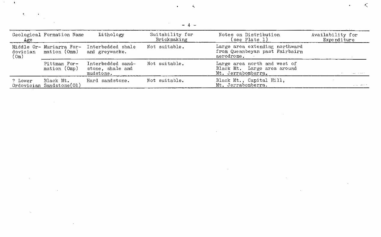
-4-
Geological Formation Name^Lithology^Suitability for^Notes on Distribution^Availability forBrickmaking^(see Plate 1) ^Expenditure
Middle Or- Muriarra For- Interbedded shaledovician mation (Omm) and greywacke.(Om)
Not suitable. Large area extending northwardfrom Queanbeyan past Fairbairnaerodrome. -
Pittman For- Interbedded sand-^Not suitable.mation (Omp)^stone, shale and
mudstone.
Large area north and west ofBlack Mt. Large area aroundMt. Jerrabomberra.
? Lower^Black Mt.^Hard sandstone.^Not suitable.^Black Mt., Capital Hill,Ordovician Sandstone(01)^ Mt. Jerrabomberra.

I .
2
-•GEOLOGY OF CANBERRA CITY DISTRICT AND SUR .R.OUNDINGS
WITH REFERENCE TO BRICK SHALE
The ge4ogy of Canberra City District has been mappedand described by Opik (1953, 1954). Further details are givenin a later publication (Opik, 1958). Neighbouring areas havebeen partly mapped by several geologists of the Bureau of MineralResources. The geological sequence is stated briefly in Table 1and is illustrated in Plate 1.
The map and the summary given in the table show that-_,4he only rock formations that are likely to contain major:A-eserves of brick shale are the Lower Silurian sediments ofthe Canberra Group and the State Circle Shale. Their southernboundary is within Canberra itself and they extend northwardsin a broad belt past the boundary of the A.C.T.
West and south of Canberra the country is occupiedby volcanic rocks and intrusive porphyries, which are notsuitable for brick-making. The Yarralumla Formation of sediment-ary rocks which contains the old Yarralumla and Deakin pits hasbeen exhausted of brick-shale, at least where it is available formining. East and south of Canberra the country consists ofOrdovician sedimentary rocks most of which cannot be used suc-cessfully for making bricks. An exception is a narrow belt ofshale at Queanbeyan which could provide good quality brickshale for perhaps 15 years.
INVESTIGATIONS OF DEPOSITS
Preliminary work was directed towards finding access-ible deposits, preferably close to the brickworks, which couldmaintain supplies temporarily. Subsequently, geological mappingwas carried out in suitable areas to delineate major deposits,one of which could be selected after detailed investigation asthe site of a permanent brick-pit. Bulk samples were to betested in a pilot plant at the brickworks. Descriptions of thedeposits investigated are given in the following paragraphs andreserves in the major deposits are summarized in Table 2.
MINOR DEPOSITS
Shale deposits were first sought in the YarralumlaFormation and the Deakin Volcanics, both of which occur nearthe brickworks. Small areas of Lower Silurian sediments ofState Circle Shale and of the Canberra group, and readilyaccessible areas of Middle Silurian sediments further eastwere examined.
BLOCK 46, BELCONNEN (PLATE 1)
A sample of shale and silty shale of the RiversideFormation taken from Block 46, at the corner of Yass . Road andBelconnen Road, by the Bureau of Mineral Resources in the year
. 1950 made good bricks in the old plant at the brickworks. Whenproduction ceased temporarily at the Deakin pit in November,.1957, about 2,000,..000 bricks were made from a pit in Block 46.However, the bricks were not satisfactory, because, it isthought, of a lack of plastic binding constituents in the mat-erial excavated. The outcrop is on a relatively steep slopein an elevated area and has little of the surfaCe covering ofplastic clay that results from advanced weathering or decompos-ition of shaly bedrock.^ •

3
BLOCK 28A WODEN PLATES 1 4 and 5
Two small deposits, the "Cemetery Road" and "Federal"Deposits are exposed in cuttings in Kent Street within Block28A, Woden District, near Red Hill.
Cemetery Road Deposit
The Cemetery Road Deposit is ai miles southwardsfrom the brickworks by bitumen road. It consists of calcareousmudstone and contains tuffaceous bands up to a few inches thick.Molds of brachiopods are fairly plentiful but no nodular lime-stone is visible. The sediments dip south-south-west at anangle of 40 degrees and at their southern edge are overlain bytuffs. Tuffs probably form the northern boundary a short dis-tance north of the road cutting.
Because Of the small thickness of suitable sedimentand the gentle topography at the locality, the available reservesdown to the level of natural drainage are small. Proved reserveseast of Kent Street amount to 21,000 cu. yd. and possible re-serves total an additional 48,000 cu. yd. of average thickness9 feet. A bulk sample from a bulldozed costen.n made satisfactorybricks. However, hard calcareous beds up to 15 inches thickimleded working of the deposit and no further development wasattempted.
In April, 1959, the broad, gently sloping area westof the road cutting, which had been mapped by the Bureau ofMineral Resources in a preliminary survey in January, 1958,, was.tested to a depth of 10 feet by means of a power auger. Thiswork showed. that the band of shale exposed on the road cuttingis quite narrow,' and a sandy and clayey overburden rapidly •increases in thickness towards the west.
Federal Deposit
The Federal Deposit, less than a mile and a haltfrom the brickworks is either the basal portion of the Yarra-lumla Formation or a sedimentary member within the Deakin Vol-canics. It consists of shale, siltstone and mudstone, slightlyhornfelsed.
A bulk sample obtained in September, 1958, madesatisfactory bricks and a short time later full-scale workingof the deposit was started. However, the hornfelsed sedimentat quite a shallow depth was too hard to work and the projectwas abandoned after about a million bricks had been made.
CANBERflA CITY DISTRICT
Cork Hill Deposit (Plates 1 and 6)
Plans for the development of Canberra provide forstripping and removing the upper part of the rounded hill,north of Parliament House, on which Cork Hill Trig was establishedin former years. The hill consists of siltstone, fine-grainedsandstone and silty mudstone of the Riverside Formation. Inearlier years its northern and north-western sides were coveredby windblown sand which has since been nearly all removed foruse in building construction. A small sample of the weatheredbedrock taken by the _Chief Geologist, Bureau of Mineral Resources,in March, 1958, ziblded.satifactory bricks when tested at thebrickworks. A bulk sample carted to the brickworks in April,1958, burned to satisfactory bricks.' , ^the end of 1958,when the Deakin pit had been worked ut, ^fu]..1 scale mining orstripping started at Cork Hill.

- 4
The material excaliated, :Consisting largely of weatheredfine sandstone l siltstone and2MudStone, makes a firm brick thatshrinks little on burning, but it is lacking in the plastic . con-stLtuents needed as a binding medium. This was initially over-come by including some of the red clayey subsoil that coveredthe surface of the bedrock. However, the reserves of this sub-soil are small.
When work started at Cork Hill approval had beenobtained to strip down to R.L. 1865'. However, the strata arefairly hard at depths of about 3 to 6 feet and it is probablethat the maximum average depth of the excavation will not exceed6 feet. Reserves of workable material downto R.L. 1865' remain-inE at Cork Hill in June, 1959, amounted to about 44,000 cubicyards. Authority was then obtained to strip down to the levelof King Edward Terrace, at about R.L. 1850' to 1855'. Allowingfor a proportion of overburden, including wind-blown sand, theadditional reserves amount to about 100,000 cu. yd. By July,1959, it was becoming increasingly difficult to obtain brick-makjng uterial that had an adequate proportion of plastic con-stituent for binding the bricks.
Ethpridge Creek (Plates 1 and 7)
The Etheridge Creek deposit of State Circle Shaleis exposed in the southern bank of Etheridge Creek on eithersidr3 of the boundarT between Belconnen District and the O'ConnorDivision of Canberra City District. In a sketch map drawn inFebruary, 1958, it is named the "O'Connor" deposit, and in alocality map drawn in April of the same year is termed the"Lyneham" deposit. It is thought better here to use the morespecific locality name "Etheridge Creek Deposit".
The deposit occurs at the northern end of a narrow,north-easterly trending belt of State Circle Shale that restsunconformably on Middle Ordovician sediments of the PittmanFormation. In the .east it terminates against Lower Ordoviciansandstone at the Black Mountain Fault. In April, 1959, thedeposit was sampled by means of a power-driven auger capableof drilling toa depth of 10 feet. Results are shown in Plate 7.A narrow band of workable shale runs south-westwards . from thecreek bank. On the west it is. limited by increasing overburden.The workable width decreases from about 300 feet near the creekto 100 to 150 feet at a distance of 900 feet from the creek.Overburden ranges from 2 to 8 feet and consists of silt, sand,and fragments of vein quartz and sandstone. Immediately belowthe overburden the shale is decomposed to a greyish and yellowish-white clay. This grades downwards through depths of two to fourfeet to very weathered shale. The thickness of suitably weatheredshale is not known but is probably at least 15 feet.
The ground surface rises fairly steeply and theave .:7age depth to the level of natural drainage, i.e. the creekbed, exceeds 30 feet. Reserves amount to 15,000 cubic yardsper yard depth of suitably weathered shale.
Trial briquettes made in the Acton laboratory of theBureau of Mineral Resources have an attractive colour, highcrushing strength, and low water absorption, but the shrinkageon burning is relatively high.^The material tested came...fromthe upii.ep4art of the weathered shale immediately below theclayey,.deComI5Osed shale. Shale excavated from a greater depthwould probabl.Y.shrink less.
T/le deposit is small and prejocably not worth developingas n brick pit. It had a prospectiveuWih providing bindingmaterial for the silty and sandy sediment woh from Cork Hill.
5
However, the logality_is now „being deveIopediat a housing area •
and is no longivravailable for mining. Its extension to thesouth-west is Covered by'deep overburden. A small outcrop inrocky ground at a higher elevation about a mile to the south-west contains bands of siltstone and perhaps fine sandstone andis much harder.
Mahon Hill (Plate 1)
Tuffaceous shale and mudstone of the Mahon Formationcontaining moulds of brachiopods is exposed on Mahon Hill eastof Narrabundah, mainly on the western and southern flanks. Theupper slopes and crest of the hill are formed of Ainslie Volcan-ic which rest unconformably on the beds of the Mahon Formation.A hard tuffaceous interbed on the western slope restricts theworkable area to a width of about 300 feet. In January, 1959,the beds exposed in a trench for a water pipe, were inspectedby officers of the brickworks and of the Bureau. It was pro-posed then that a bulk sample should be taken to the brickworks,but because of the apparent, small size of the deposit, and apossibility that the beds wOuld be too hard to work and lackingin plastic constituents at a shallow depth, the sampling projectwas abandoned.
MAJOR DEPOSITS
Investigations of large deposits was of necessityrestricted to the large areas of Silurian sediments north ofCanberra and to the shale north of Mt. Jerrabomberra, Queanbeyan.
QUEANBEYAN DEPOSIT (PLATES 1 and 8)
The Queanbeyan deposit extends 2800 feet north-westand 1500 feet south-east from Tharwa Road cutting north ofMt. Jerrabomberra. It was examined several years ago by theChief Geologist, Bureau of Mineral Resources, and a large samplefrom south of Tharwa Road was made up into satisfactory bricksat a Sydney brickworks. In August, 1958, a bulk sample from thenorthern side of the road cutting yielded good quality brick atthe Canberra brickworks. In December, 1958, the deposit wasmapped by the Bureau of Mineral Resources (Turner, 1959) and anestimate made of resources.
The body of shale has been thought to be a unit ofthe Muriarra Formation mapped by Phillips (1952). However itlacks the sandy interbeds that are characteristic of that formation.The structure at the locality is complex and the shale could wellbe Lower Silurian in age, equivalent to the State Circle Shale.
- Upper and Middle Ordovician sediments form parallel bands to theeast of the brick shale: Lower Silurian sandstone and UpperOrdovician Silicean shale occur to the west.
Reserves estimated by Turner amount to:
Probable^488,000 cubic yardsof average thickness^feet
tPos.sib^.93,000,cubic yards.^average thickness • 1() feet.
This' is probably1t5W an estimate. TT the shaleis sufficientl.Y-WPahered -tObeWOrkatie s down to . 0t,..th of30 feet the probable reserve s would be 876,000 cub yards andthe possible reserves 130,000 cubic yards. The tr0
- figure issomewhere between these estimates and could be 'estipated aftertesting at depth.
-6-
The deposit lies within the boundaries of the Town ofQueanbeyan in an area that should be attractive for futureresidential development. Houses are now being built withinabout a third of a mile of it.
DEPOSITS NORTH OF CANBERRA
General
Reconnaissances made at intervals early in 1958confirmed the presence of large areas of shaly sediment, northof Canberra, that might be suitable for brickmaking. A broadarea (Plate 2) was mapped at photo scale early in 1959 byE.G. Wilson of the Bureau, and for part of the time by J. Standardwho worked with the Bureau for a short period. Prospectivesources of brick-shale inspected during the mapping includedthe belt of (?) Turner-shaIe, aIong Gundaroo Road and at MulligansFlat, shaly sediment of the ^FormatfOn at Gungaderraproperty and at Crace Trig., and State Cirole.Shale in Bloc9south of Be1conn6T-R-E757I7Wireless Station.
Further examination revealed that the (?) Turner Shale isvery slightly hornfelsed and is probably too hard at a shallowdepth. The Gungaderra and Orace Trig, deposits were sampled inMarch, 1959, and the Belconnen deposit in April, using a truck-saounted power auger that bores a hole nearly 18 inches in diameter.
Crace Trig, deposit was diamond drilled in April to test thedepth of weathering. Bulk samples obtained from the auger holessere trucked to the brickworks. Unfortunately the pilot planttad broken down and no testing was done there. However trial.5riquettes were made and burned at the Bureau of Mineral ResourcesLaboratory, Acton, and these indicate the relative brick-makingP)tentialities of the different samples of shale.
In addition to the deposits just mentioned potentialbrck shale with large possible reserves occurs in Block 6, sit-uaed l to 2 miles west of Gungaderra Deposit, and in Blocks98A, and 13A, situated^and -2 miles east-north-east, respectively,froh Crace Trig. deposit.
In Block 6 silty shale, mudstone, siltstone, and minorbands of volcanic rocks form the higher ground between the trib-utariAs of Ginnialderra Creek. The beds are nearly all hardened insome d6gree by hornfelsing. In the southern part,^the hornfelsingis no pronounced but towards the north it becomes increasinglyevident, and the beds outcropping in the creeks are very hard andbritte. Numerous quartz veins occur within the area and some ofthe outcropping sedimentary beds are silicified. Small localreserves of weathered shaly sediment are probably suitable forbricktaking..
In Block 98A, within an area of gently sloping ground,shales and silty shales, which may form part of the RiversideFormEltion are exposed beneath a few feet of overburden in creeksand in excavations for earth dams. Possible reserves are verylarge, but because of the gentle topography a brick-pit could beworked to only a very shallow depth if relying on natural drainageto keep it dry.
In Block 13A calcareous shale, mudstone, siltstoneand lenticular bands of limestone are exposed on a fairly steep
• slope that leads up to a large outcrop Of sheared porphyry. Thetopography is very suitable for working:a pit, and reserves areprobably considerable', though much smaller than in the other areasexamined. It is quite likely that nodular limestone occurs errat-
,^ically within the deposit.

7
Mulligan's Flat.^,
A belt of hbrrifelsed shale forms the prominent riagethat runs north of Mul1igar2sTIat past the A.C.T. boundarythe eastern side of Gundaroo Road. At several localities the jlower slope of the ridge is deeply weathered and contains possiblelarge reserves of brick shale. In view of the considerablereserves known to exist at localities closer to Canberra theMulligaris Flat deposits have not been examined in detail.
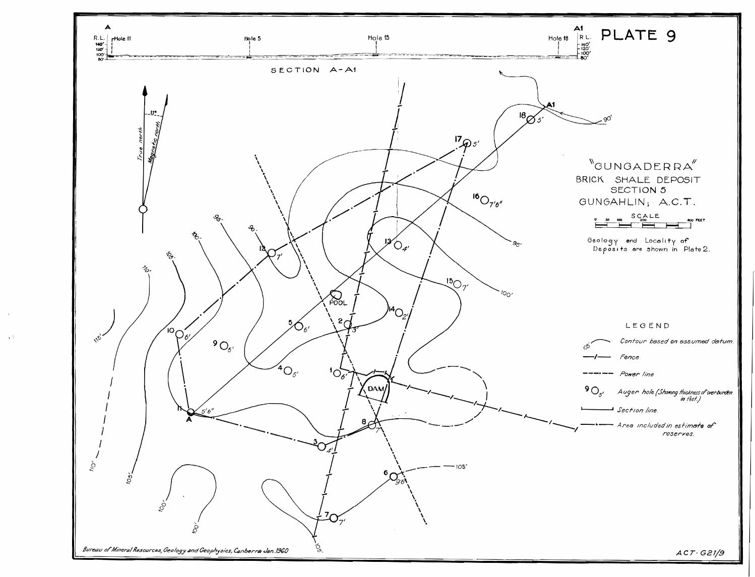
Gungaderra Deposit (Plates 1 and 9)
In the vicinity of Gungaderra property the belt of,Riverside Formation is constricted by a broad outcrop of Ordovicianbeds adjacent to a major fault. On the western side of the • aUltthe belt widens to the west and runs off to the north-northeast l .
On the eastern side it widens to the east and runs south-south7west past Crace Trig. The northern part of the belt contains , lheGungaderra deposit and has been referred to as the GungaderraAree, ;
At the locality tested, very weathered buff andyellowish-brown shale containing abundant brachiopod molds is
exposed in the material excavated from an earth dam. A smallarea was mapped by plane table and alidade and sampled with apower auger to depths ranging up to 20 feet. Bulk .samples Weretrucked to the brickworks. Results of the work are shown inPlate 9.
The area has little surface relief. ReserVesdeWn tothe level of natural surface drainage at the locality batpiedare summarized below.
Area Tested^ 86,000 sq. yd.
Average depth from surfaceto level of natural drainage^6.4 feet
Average thickness of overburden^4 feet
Average thickness of shale to levelof natural drainage^2.4 feet
Reserves in area tested down tolevel of natural drainage^69,000 cu. yd.
Provided that the deposit could be worked below thelevel of natural drainage, i.e. in a pit that could be kept dryby pumping, large reserves would be available. The total mappedextent of this northern portion of the belt of Riverside sedimentis about 1 square mile, and the reserves of shale similar to thatsampled at Gungaderra must be very large. Because of the unfav-ourable topography no further work was done in the area.
Crace Trig. Deposit (Plates 1 and 10)
The southern portion of the belt of 'Riverside Formation,in which the Crace Trig, deposit is situated, consists of shale,mudstone, siltstone, and minor tuffaceous beds. It stretches.across from about 2 CY radio station on the west almost to
'7.'BuI1ivans Creek on the east and extends north-north-east past:0Ye1ls Station. The western edge of the belt is relatively,:elevated and has little •ornone of the'superficial clayey,
decomposed shale that i.“*.id in the lower lying areas. Thismay explain the apparent lak of binding material in the siltyand shaly^excavatedfor briCkffiaking from Block 46during 1957.' The*midale .se:Ofion of the belt ., a ;broad slightly
. 1

25.8 feet
2 feet (apprax4
23.8 feet
2,700,000 cu. 374:
• ■
elevated area4 is cut -by•Aseveral fadlt,s that trend north-north-east. Narrow quartz reefs and veins are 'associated with thefaults. '
Part of the western portion of the belt of Riversid'Ssediments, north of Crace Trig;, was mapped by plane table andalidade and sampled by means of . a, power auger in March, 1959..It was diamond drilled in April, 1959, in order to ascertain .
the thickness of weathered shale. The area contains more shaleand mudstone and less siltstone than do the beds exposed in the .excavation on Block 46, and in addition it is more deeply weathered.The shale is exposed at the surface over small areas and elsewhereis covered by red clayey overburden that thickens considerablytowards the east in the lower ground near the natural drainagechannel. A pit could be worked to a recoverable depth whilemaintaining sufficient gradient to allow natural drainage.
Reserves in the area tested down to the level ofnatural drainage are as follows:
Area tested^ 342,000 sq. y .
Average depth from surface tolevel of natural drainge
Average thickness of overburden
Average thickness of shale down tolevel of natural drainage
Reserves in area tested down tolevel of natural drainage
Diamond drilling has shown that the shale is weathereddown to an average depth of 48 feet and possibly it could 156worked down almost to this depth in a pit kept dry by pumping.However, the shale may not contain sufficient plastic materialdown to this depth to be suitable for brick-making.
Plate 1 shows that the deposit tested forms only asmall . fraction of the southern portion of the belt of RiversideEortaion . sediments, excluding low-lying sections that cannot
drained, the potential reserves in the whole area arevery large- .
Trial briquettes made and burned at the Bureau ofMineral Resources laboratory, Acton, compare favourably withbriquettes made from shale from other localities (Table 3).The colour is pleasing, provided the briquette is not over-burned, crushing strength is well above the average, waterabsorption less than the average and shrinkage on burning isa little lower than the average, though it is higher than thatrecorded for briquettes made from Cork Hill sediment. One batchof briquettes burned in the laboratory were a little dark incolour and one briquette was partly glazed on its surface. Thissuggests that the firing temperature may be more critical thanwith some of the other shale samples tested.
In July, 1959, a bulk sample was bulldozed from a longcut with a maximum depth of 12 feet from the surface, in orderto provide a lArgo-scale test of the shale at the brickworks.At the locality sampled overburden consists of red clayey sailand sub-soil and is . 6 inches to 1 foot thick. The upper 2 feetof the shale bee.dthrii.:S0eaomposed:to a greyish and yellowish-white clay. T-4S15'edsbenth are .:very weathered down to about10 feet from the surface ^easily ripped with the bulldozer.Below this, to the bottom ,of the cut, ::t116:1,saei harder, but-can still be rippecte-'''
9
In the brickmaking tests, 'it ;was. found that thesuperficial clayey .decomposed shale .:had„.toHbe added to theweathered 'shale to obtain satisfactresUlts. Otherwisethe green bricks lacked coherence and' broke as they wereforced out of the mould in the brickmaking machine. Theburned bricks have a pleasing dark-red colour and are excep-tionally hard. However, they have shrunk excessively andapparently because of the high shrinkage some of them havecracked. It appears that in order to utilize the Crace TrigLshale, a different brickmaking process from that in use at theCanberra Brickworks would have to be adopted. It is possiblethat shrinkage and cracking could be minimised by careful controlof the rate of increase of temperature and of the firing temper- .-ature, but considerable experimental work would be necessary toconfirm this and to establish the optimum conditions.
Belconnen Deposit (Plates 1 and 11)
The Belconnen Deposits, consisting of State CircleShale, extends north-north-east from Block 29, Belconnen,
-through the Naval Wireless Station on Block 78 and continues asa narrow belt through Blocks 45 and 15 up to nearly a mile pastBarton .Highway. Prospective brick shale occurs in Blocks 15, 29 1:'and the eouthern part of Block 78. Block 15 is within C.S.I.R.0property and has not been investigated. In the northern part of .
Block '78 the beds are silty and probably not suitable for briek-:.making. A very poor road or stock route that runs through thesouthern part of the area, dividing Block 29 into western andeastern portions, joins Weetangera Road about 2 miles to thesouth-west. To the north-east it skirts around the wireless .station and in a distance of 1 mile joins a bitumen sealed roadthat joins up with the Barton Highway. The western portion ofBlotk 29 has been acquired by C.S.I.R.O. and presumably the onlypart of the shale deposit available for exploitatiOn is thatwhich is situated in the eastern portion of Block 29.
The terrain has moderate relief and a pit could beworked to a reasonable depth without encountering drainage . ..troubles. A small area was mapped by plane table and alidadein April, 1959, and sampled by auger to a maximum depth of 10 feet.Bulk samples were transplanted to the brickworks but have notbeen tested. Trial briquettes made at Bureau of Mineral Resourceslaboratory (Table 3) are a little paler than the Crace Trig.Hbriquettes. They have a high crushing strength and low water:absorption, but shrinkage on burning is relatively high. Probablyless weathered shale from greater depths would shrink less.
below.^A summary of reserves in the area tested is given
Area tested^ 52,000 sq. yd.
Average depth from surface to level ofnatural drainage^ 25.8 feet
Average thickness of overburden^3 feet
Average thickness of weathered shale tolevel of naturaldrainage^ 20.8 feet
Reserves per 1-yard thickness of suitablyweathered shale,:^'^ 52,000 cu. yd.
'Possible reserves in area telsed, t 9, levelOf natural drainage^.364,000 Cu. yd.
'The known area of thedeposit south of Barton Highwayis approximately li million sq:yd,.., of which 84 per cent is inC.S.I.R.O. property and the Navgi 'Wireless Station. Totalpossible reserves outside these properties in the eastern partof Block 29, down to the level of natural drainage, amounts to780,000 cu. yd.
LABORATORY TESTING OF BRICK SHALE
Laboratory testing of samples of shale from the*itealdeposits was prompted by discussions with Dr. H.H. Macey of Perth,Western Australia, who acted as a consultant on brickmakifig tO theDepartment of the Interior during April, 1959.
Experimental briquettes 3" x li" x 1" in size weremade at the Bureau of Mineral Resources Laboratory, Acton, fromsamples taken from the various brick-shale deposits. , The mouldused, 3" x li" x 2" in size, was made up from steel plate i"thick. The sides and ends are bolted together and rest on abase plate. The pressure plate is forced into the mold in asmall hydraulic press.
Shale samples were crushed in a laboratory jaw- crusherto pass 1/10 inch mesh sieve and the finer amounting to lessthan 10% of the crushed shale (visual estimate) were removed witha 60-Mesh sieve. The resulting maximum partial size .differs alittle from that at brickworks, where the mesh size Of thebottom plates of the grinders is 1/8 inch. In additiOri thefines are not removed at the brickworks. In making : the briquettes,a measured proportion of the clayey decomposed shale fl he upperpart of each deposit was added to the weathered shaiMixingwas done by hand in a shallow tin dish, and only en
solUgh,Water wasadded to enable the crushed shale to cohere when preed together....ih•:thelhand. The mixed moist shale was placed in thDMilild to its'fulI- 2- inch depth and pressed down to a thickness Of linch inthe hydraulic press. The press used for the initial batcheswas fitted with a pressure gauge and the total load Aplied ona 'briquette ranged from 2i to 5 tons. The press uSed forlaterbatches had no gauge.
Briquettes were burnt in a laboratory oven which hada Capacity of 16 briquettes. Commonly about 15 briCkS.made upa batch. The oven charged with the batch of briqUe7tteS wasswitched on at 5 p.m. and the temperature brought,Up . eVernightto 800'C. In the first tests the temperature was then broughtslowly up to 1000'C, from 8.30 a.m. to about middaS^The ovenwas then switched off and allowed to cool. The briqUettes weregenerally taken out during the afternoon of that day In asecond series of tests the procedure wa8 as described, exceptthat the briquettes were raised to 1050 C. In a third series oftests they were maintained at 1050°C for 3 days, and in a fourthtest, at 1000'C for three days.
After cooling, the briquettes were measured, in orderto ascertain shrinkage. They were then weighed, soaked in waterovernight and re-weighed to determine water absorption. Onebriquette of each sample of shale was tested at the Works Dept.laboratory for crushing strength. The 3" x li" faces werecapped by caneite cut to rectangles measuring about 31" x 171"and pressure applied at the rate of about 19 tons per minute.
An 'additional batch ofiqUpftfeowas burned at thehrIOworks . Ydnakiin;:of common hOU'sepricle6,. The results ofthe experimental ^on the:brigiaettes. are summarized inNble 3.V%

The.briquettesTha overnight at 1000 °C and 1050°Care pale :c.olpured,and-easil Scratched with a knife. ° They areobviously t0,o soft. Those burned for 3 days at 1000 C can bescratched, though not readily, and have a pale pinkish-buffcolour. The briquettes burned for 3 days at 1050 C all have apleasing deep red colour and are not scratched by a knife. Theorder of increasing shrinkage is Cork Hill shale, Queanbeyanshale, Crace Trig shale, Belconnen shale and Etheridge Creekshale. The briquettes burned at the brickworks were satiS-factory excepting one of each three briquettes made up fromCrace Trig. and Belconnen shale. These had become blackenedand partly fused. Order of increasing shrinkage is Cdi-k Hillshale, Queanbeyan shale and, together, Crace Trig., Beiconnenand Etheridge Creek shales.
REFERENCES
GARDNER, D.E. and PRITCHARD, P.W., 1957 - Geological rep*,t : onthe brick pit at Deakin. Bur.Min.Resour.Aust.Re& 1957/93.
NYE, P.B. and OWEN, H.B., 1944 - Geological report on a Si .'Wfor a brick pit at Deakin. Bur.Min.Resour.Aust.B'Sta,1944/28.
OPIK, A.A., 1953 - Geological map of Canberra. Bur.Min.ReCUr.'Aust.^Drawing A.C.T.^C2-12.
-- OPIK, A.A., 1954 - In "Canberra, a Nations Capital", ed. byH.L. White. Aust.Assoc.Ad.Sdi.Canberra, 1954.
()PIK, A.A., 1958 - The geology of the Canberra City disiii0t;Bur.Min.Resour.Aust.Bull. 32.
PHILLIPS, J., 1952 - Geology of the Queanbeyan district;Unpub. honours thesis, Univ. Sydney.
TURNER, E.W., 1959 - Preliminary report on the brick shaledeposit at Queanbeyan. Bur.Min.Resour.Aust. 1959/2.

Possible super-ficial extensionof Deposit
Remarks
1 . 2.4 69,000Gungaderra^86,000 To R.L. 90 1 *^4' approx.
6.4'
23.8 '342,000 2 700,00b2.*Cr'a,6& Tri(Gufighald41 .
Approx. l sq.miles
Diamond dril#11g:shows suitable'shale to average„.„depth of 48'.^-'Reserves to thisdepth amount to6,000,000 cu.yd.(in area tested)
To R.L. 85 1 *^2' approx.25.8'
52,000Belconnen To R.L. 70 1 *^3' approx.23.8'
Area tested Average Depth_ 4VerageSq. Yd.^to Level of Nat- -thirden (
ural Drainage(Feet)
Averagethicknessof shale'to NaturalDrainageLevel(Feet).
AREA Reserves inarea testedto NaturaI-:DrainageLevel (Cu.Yd.)
Over -Feet)
Approx. 1 sq.mile.
Thickness of suit-cibly weatheredshale not tested;least 30 ft.
Nearlyuseful shal,below leVelof-natural drainage.
20.8'^364,000^More than 500,000sq. yd. Of thisarea, 69% is inC.S.I.R.O. propertyand has possible-reserves of li mil-lion cu. yd.
Possible exten-sion of 29,000 sq.
dyd. at northernend, containingPossible 1 -30,000
Shale tested todepth of 10 ft.Probably suitableat lea:St to 30 ft.Total probablereserved in South-wells Propertyamount to 780,000cu.yd. Shale not sampledbelow surface.Itis assumed thatsuitably weatheredshale persists
TABLE 2
BRICK-SHALE RESOURCES OF CANBERRA
Deposit- No..and Name .(ee Map) .
Not tested.Probably 4'.
129,0004. Queanbeyan ExceedsQuality'below surfaceAnot tested.
30 ft. 876,000 downof shale to R.L.350
or to assumemaximum offl ft. of
_To RL. 350'*-*111.nOrth of:Tharwa Rd.,39 1 .- (Theater thickness

-^TABLE 3 CONSTITUENTS, FIRING DATA AND PROPERTIES OF TRIAL. BRIQUETTES
DEPOSIT 3RIQU, 1 CONSTITUENTS IrRING DATA 'SHRINK-TTE NO.^ !AGE OF
[3" FACEI(IFCHES)
RUSHING STRENGTH =OAD APPLIED TO LARGEFACEITOTAL^LBS./SQ.IN.
REMARKS
tested
tested3,440
3,970 be-foreburn-ing
12.4
5,310
5,340
14.3
CORK HILL^1^rom brickworksalready crush-ed & ground
216
2O&23
31
26
38
Heated over-1 Nil•nigh to1000 C thenallowed tocool
NilHeated over- Nilnight to1050 C thenallowed tocool
Heated for 3 1 Nildays at 1000 °CHeated for 31days at 1050'C
Burned at^Frombriokworks
Light buff colour beforeburning, coarse grained.
Light colour before burning,coarse texture large grainsize.
20 -coarsely grained,uneven23 -flecked, more even grained,
not so coarse
Dark buff-brown with whiteflecks, coarse grain size,even texture, before burning,Fairly clayey, darker brown,white flecks (green, chocol-ate brown, white flecks,uneven texture, coarse grain-ed before burning
132
2
I Not tested1^16.1
16.1
14.7
Not15,500
17,500
23,900
23,000
17,200
I Heated over-1 Nil to
night to 1000°Cthen allowed to 77
cool^IHeated over- 0 Nil tonight to 1000 C1-11("1 01710wed to^32
tested
tested2
(Coarse grained, small cracks(before burning dirty cream(& grey-buff colour, flecked(0,10,11 were even grained,
i (finer)," fairly clayey and(solid. Porous after firing.
1"
CRACE TRIG. 8
1 13
1012
1 clay: 9weathered
shale
11 clay: 6'weathered1
Approx.16:1
16.8
Not
Not .

6,380 ! irm t even grained,medium gran-plar(before burning)
1
^
2,490^Cracked when mouldingient clay to bind,
^
5,100^'Dark buff-brown before burning,'more clay for binding.i
^
7,890^ Green-buff colour,even grainedbefore firing.Light buff colour, even, finegrained, smooth texture befOr:eburning. Suffix L denotes
)(laboratory firing - B for„)(brickworks firing. Some bricks)(from this batch were also burn-) ed at the brickwrks: recorded)(same shrinkage.
1^13.3
IRot tested11.1
- -2 - -
REMARKSDEPOSIT BRIQUETTE' CONSTITUENTS FIRING DATA'^NO.
ISHRINXAGE krATER ABSORP-F 3"FACE rim AFTER
I(INCHES)^BURNING (5)
RUSHING STRENGTHOAD APPLIED TO LARGEACE
OTAL^iLBS./SQ.IN.
CRACE TRIG,1 14
(CONTINIM)
^
Neathered shale Heated overi^^2 nigh-8 to^1^321050 C then
shale (drill
allowed tocool
hale from drillore
tLpore):3 weath.!shaleWeathered shaleonly
Heatedays
32^32Heated for 3 5days at 1050 -, C -57Burned at brick- 6works^1^72-
It
It
d forat 3 01000 C
Nil
-372 324
32
2
-^I;
NOT^TESTED
NOT , TESTED
4,620
5,840
4,460
11,630
,:.
I Light grey-buff' in colour,leven grained (beforeurning).!Darker green-chocap:te,even!grained before firing,
^i----^rFirm though fine cracks vis-rible around grains,bef ore(burring; coarse grained.iDal-
k buff colour ueiore -liCtfil-
9 weatheredshale:1 tuff
4
4Tr4 - 532 77-4 32
3 - 4
27,500
11,200
22,000
34,000
21,760
21,310
21,540
19,100
24,100
18,400
47,000
41,500
21
22
30
39L
40L
41L
11.8
10.7
10.8
12 . 4
8.4
9.1
9.7
7.6
4.5
39B Burned at brick-works
40B^It
41B^
It
•25^Weathered shale
only35^Weathered shal
only
3 ) 1 clay:9 weath-A ) prPd shale
Heated Ryer ight 1to 1000'C then^-77allowed -co coo'.

DEPOSITRIQUETTEiCONSTITUENTS FIRM' DATA SHRINKAGENO. 1^ F 3"FACE ITION AFTER
1^ (INCHES)^BURNING (%)
IWATa ABSORP-
•
BELCONNEN
(CONTINUED)
QUEANBEYAN 17A & B Weath. shale
incl.a littleclay.
ETHERIDGECREEK
)1 clay:5 weath-7 )ered shale
15 1 clay:9 weath-ered shale
33 1 clay:9 weath-ered shale
28 1 clay:9 weath-ered shale
36 1 clay:9 weath-ered shale
I29 'Shale only
24 kale only
i34 Shale only
19 1 clay:6 weath-ered shale
132 1 clay:9 weath-lered shale
27 .1 clay:9 weath-tiered shale
37 'Weathered shaleofv_i_Lai a Jibu_i_e
1 19,000
42,000
48,000
36,500
CRUSHING STRENGTH=LOAD APPLIED TO LARGEFACE TOTAL
NOT
17,200
27,800
40,500
35 000 22,000
31,200
35,500
LBS./SQ.IN
TESTED
9,950
12,440
3,990
6,450
9,810
5,100
7,550
9,390
t^—57---I
Heated over^1^13.6nighto 1000 C thenallowed tocoolHeated over- ,^2 1^11.9night to 1050-C —37then allowed tocoolHeated for 3 0^3
1^10.5
days at 1000 °C 77-Heated for 3^6.6days at 1050
0^7
7
6^4.4C^7-
Burned at 1brickworks^7"2--
1
Heated over-^2^13.8night to^321050 C thenallowed to Icool.Heated for 3 0^2^12.3days at 1000°C -7--Heated for 3 0^4^7.7days at 1050 C 77-Burned at brick- 5works^-32— ^6.7Heated svernight 2to 1050 C then 77-allowed to cool.Heated or 3 days 4
32at 1000 C8Heated or 3 days
at 1050 CBurned at brick-
REMARKS
(Not so coarse, slightly(granular, firm no cracks(before burning
Smooth even texture clayey,no fines in mixture ('60 mesh),when green.
16,7
13.5
7.1
8.9
4,410^A little coarse before burn-ing.

--4--
DEPOSIT
...^_
BRIQUETTENO.
CONSTITUENTS I FIRING DATA^'SHRINKAGEIOF 3" FACE1TION(INCHES) -T .:
.., ;:?
-,WATERAFTER^- -11.10,AD
13URNING: (%):' .1:FACE1.^• j
ABSORP7- ,CRUSHING.._.^...,^,..
STRENGHT =^IAPPLIED TO LARGE^1 REMARKS
_^..^...
TI-TOTAL^I LBS./SQ. IN...^...^.; DEAKIN
.^-..1^18
IWeatheredshale incl.^al!little clay
I Heated over—night to 1050'C
I then allowedI cool
,^2^-..i;Tr-
toI
^. ^•^-^-^'^•:.,_,^.^,.
^
_:_-_.'^11.1^• '^.^si----1'-'
I
-23,- 500^-1—:1-
1 1̂
.... _ 5,450 I^One cracked on moulding
„^,