Embed Size (px)
Citation preview

1
Final Report
Identify Critical Fish Habitats in the Mekong River,
Chiang Rai Province, Thailand
Prepared by
Mr. Boonsong Sricharoendham
Ms. Suthida Soebeen
Ms. Parichat Musikatham
Ms. Siriwan Suksri
Department of Fisheries, Thailand,
December 2015

2
Executive summary
The study on identify critical fish habitats in the Mekong River, Chiang Rai Province,
Thailand (activity 2.2.1) is an activity under the project of Transboundary Fisheries Management
in the Bordering Provinces of Bokeo, Lao PDR, and Chiang Rai, Thailand. The objectives are; 1)
to identify critical habitats for spawning, nursing and refuge during dry season, 2) to discuss the
relevance of these habitats for recruitment capacity of fish stocks and 3) to explore ideas for
conservation of these habitats and implications for local and transboundary fisheries management.
All data collection and field surveys were conducted at the four target villages and their monitoring
sites nearby during June 2014 to October 2015. The 4 target villages composted of; 1) Ban Don
Tee, Ban Muang Kan, 3) Ban Pak Ing Tai and 4) Ban Huai Luek where covered the distance of
Mekong mainstream about 80-90 km long. PRA study and LEK expert interview were applied
in the village with local communities and fisher expert. Also dominant fish gonad development
and fish larvae sampling were also investigated in those area.
The result found that the Mekong mainstream in Chiang Rai province located at the
middle part of the total Mekong river length where about 400 m above mean sea level and
2,200 to 2,300 km far from the river headwater. The characteristic of the Mekong mainstream
in these 4 targets villages were quite difference together. At present, the high water regime
started from June to November, and the rising period of water regime was in June to
September. From interviewing of 28 expert fishers in those 4 target villages found that their
age ranged between 32-65 years old with an average of 48.1 years. The average fishing
experience was about 29.1 year but did not much vary with the age of fisher.
At Ban Don Tee and Ban Muang Kan villages where located about 40 and 25 km
above Chiang Khong district were surrounding of others 3-4 communities. It has to be many
small rapids and deep pool area between these 2 villages which more appropriate for fish
spawning ground and refuge habitats in dry season period. For nursing ground, it was high
variation for Ban Don Tee, may be due to the strong velocity of Mekong mainstream in this
sites. While Ban Muang Kan where the river stream expanded which connected to swamp and
flood area was still suitable condition for nursing habitat.
At Ban Pak Ing Tai village about 15 km below Chiang Khong district where it was a
quite high of fishing pressure. There was low efficiency of spawning ground in the upper part
of village but still has more efficiency in the lower part where located of a few rapids and small
deep pool. This site also has some good habitat for nursing ground such as in the Ing river area.
At Ban Huai Luek village where located about 40 km below Chiang Khong district, some
lower part of this village was also good location for fish spawning ground and refuge habitats
which many rapids and deep pool area.
From scientific validation on investigation of dominance fish gonad development
found that many dominant fish species can be achieved to the upper most area of Ban Don Tee
village. It was confirmed that those fish species also migrated for searching their spawning
ground to this area. Also for fish larvae surveys around those 4 villages were proved that there
were many fish larvae and fingerling availability in those areas for nursing habitats. In
conclusion, there are many management option can be applied to transboundary fisheries
management in this area, if the two bordering provinces and countries has joint cooperation.

3
Table of Contents
1. Introduction 1
2. Objectives of the study 1
3. Expected Outputs 2
4. Literature review 2
4.1 Habitats types 2
4.2 Fish diversity and abundance 2
4.3 Fishing ground 4
4.4 Fisheries regulation 4
5. Methodology of study 8
5.1 Study area 8
5.2 Study period and site visit 9
5.3 Methods for data collection 9
5.4 Data analysis and comparison 10
6. Results and discussion 14
6.1 Characteristic of Mekong mainstream at 4 study sites 14
6.2 LEK and information from fisher expert 17
6.3 Scientific validation of spawning habitats 32
6.4 Scientific validation of nursing habitats 34
6.5 Habitat ground truth and GPS positioning 38
6.6 Rechecking data by focus group discussion 39
6.7 Integrated information analysis 39
7. Conclusion 41
8. Recommendation 41
9. References 42

4
Lists of Figures
Figure 1 Map of the Mekong Ecosystems along the Mekong River in Chiang Rai
province.
3
Figure 2 Map of fish conservation zones in Chiang Khong to Wieng Kane area. 7
Figure 3 Map of study sites of 4 target villages in Chiang Rai province, Thailand. 8
Figure 4 PRA study, group discussion with the LEK expert, and face to face expert fisher
interview for investigation of critical fish habitat in the 4 target villages.
11
Figure 5 Validation of spawning ground by investigation of gonad development of
dominant fish species in the 4 target villages during April 2014 to August 2015.
12
Figure 6 Mapping on all sampling stations of nursing ground survey in the 4 target
villages.
12
Figure 7 Validation of nursing ground by investigation of fish larvae survey from 14
stations in the 4 target villages during October 2014 and June 2015.
13
Figure 8 Fishing ground at the 4 villages during the study period of 2014-2015. 15
Figure 9 The topography and profile of Mekong mainstream in Chiang Rai province. 16
Figure 10 Daily water regime of Mekong river at Chiang Saen station during 2012-2015. 16
Figure 11 All of fisher expert in the 4 target villages who providing fish habitats and
fishing characteristic information in the Mekong mainstream.
17
Figure 12 Information on resources mapping and habitats of 4 targets villages along the
Mekong mainstream.
19
Figure 13 Mapping resources of community, fishing ground and habitats around Ban
Don Tee.
24
Figure 14 Mapping resources of community, fishing ground and habitats around Ban
Muang Kan.
25
Figure 15 Mapping resources of community, fishing ground and habitats around Ban
Pak Ing Tai.
26
Figure 16 Mapping resources of community, fishing ground and habitats around Ban
Huai Luek.
27
Figure 17 Pictures of fish conservation zone in the Mekong River of those 4 target
villages.
29
Figure 18 Pictures of fish spawning habitats in Mekong mainstream, information from
interviewing of fisher expert in 4 target villages.
30
Figure 19 Pictures of critical fish habitats of refuge in dry season in the Mekong
mainstream, information from fisher expert interviewing in 4 target villages.
31
Figure 20 Pictures of activities of gonad development investigation in the 4 target
villages.
33
Figure 21 The abundance of fish larvae survey from 4 target village during 2014-2015. 34
Figure 22 Comparison of fisheries potential in the study area from 6 dimensions of 14
topics.
40

1
Lists of Table
Table 1 List of fish species name found in the Mekong river of Chiang Rai province. 5
Table 2 Processes of FCZs establishment in Chiang Khong under the WWF project. 6
Table 3 Fish Conservation Zones (FCZ) in Chiang Khong district established under
WWF project
7
Table 4 The characteristic of the Mekong mainstream at the area of 4 target villages. 14
Table 5 List of fisher name, location and their experiences of the expert fisher
from 4 target villages of the Mekong mainstream in Chiang Rai province.
18
Table 6 Summarize information derived from PRA study and expert fisher
interview at 4 target villages.
20
Table 7 Summarizes of fishing activities and gear used from PRA study and
expert fisher interview at 4 target villages.
21
Table 8 List of critical fish habitats found in the Mekong mainstream and their
tributaries from 4 target villages.
28
Table 9 Information from investigation of gonad development of dominant species
at 4 target village during July 2014 - August 2015.
32
Table 10 The result of fish larvae survey from 4 target village during 2014-2015. 34
Table 11 Species and number of fish larvae (ind./100m2) found from 4 target
village during the survey of August 2014 and June 2015.
35
Table 12 The GPS positioning f fish conservation zone in the Mekong River of those 4
target villages.
38
Table 13 Group discussion for recheck of all habitats investigation in 4 target
villages.
39
Table 14 Comparison of fisheries potential in the 4 target study areas from 6
dimensions of 14 topics consideration.
40
1
Identify Critical Fish Habitats in the Mekong River,
Chiang Rai Province, Thailand
(Activity 2.2.1)
1. Introduction
1.1 Background
The development activities implemented in the Mekong River in one country can affect
also the other riparian countries. Fisheries are interlinked, from local to regional levels crossing
national boundaries of riparian countries, the development in the Mekong river basin initiatives
can affect the abundance fisheries resources, which consequently directly impact on people’s
livelihoods. Therefore, fisheries management in the Mekong river basin is ideally planned and
implemented by using a geographically integrated and trans-boundary approach.
This project implementation of Thailand national activities is prepared based on the
project document Transboundary Fisheries Management on the Mekong River in the Bordering
provinces of Bokeo, Lao PDR and Chiang Rai, Thailand, which was developed with actively
supported by the National Mekong Committee (NMCs), the fisheries line agencies and relevant
parties from the various levels and local authorities of the respective countries (Lao PDR and
Thailand).
Trans-boundary fisheries management project is reflected in the programme document
of FP 2011-2015, where activities “3.2: Draft regional fisheries cooperation framework
(Identify/implement pilot trans-boundary, cross-border and basin-wide fisheries management
activities)” and “4.2: Address bi-national management issues” related to trans-boundary
fisheries management.
2. Objectives of the study
1. To identify together with expert fishers the critical habitats for spawning, nursing
and refuge during dry season
2. To discuss the relevance of these habitats for recruitment capacity of fish stocks
(local and trans-boundary)
3. Explore ideas for conservation of these habitats and implications for local and trans-
boundary fisheries management

2
3. Expected Outputs
1. Local ecological knowledge (LEK) on identification of fish spawning, nursing
grounds and refuge habitats;
2. Information about location, seasonal gears and specific use of spawning, nursing and
refuge habitats gathered;
3. Critical fish habitats, i.e. spawning, nursing and dry season refuge habitats for
conservation and fishing in seasonal perspective identified.
4. Literature Reviews
4.1 Habitat types
The Mekong River in Chiang Rai province at Khon Phi Luang Rapids area hosts a
complex riverine ecosystem consisting of 11 different sub-ecosystems, which is dependent on
seasonal water level of the Mekong River (Figure 1). For instance 1) Pha (part of rapid above
water layer), 2) Kok (deep pool), 3) Don (sand bar), 4) Haad (sand or pebble beach), 5) Rong
(water channel), 6) Long (oxbow), 7) Nong (swamp), 8) Jam (larger rapids that make
whirlpool), 9) Huai (stream), 10) Rim Fang (riverbank), and 11) Kwan (large shallow deep
pool). Some of these sub-ecosystems are vital habitats and spawning grounds for fish, as well
as important fishing ground for fishers. For example, the Kok sub-ecosystem, in dry season
when the water is lower than five meter, is fish habitat and spawning ground for several fish
species (Sukhumasavin, 2013).
4.2 Fish diversity and abundance
The Chiang Khong-Wieng Kane Research Group (2004 & 2006) studied in Chiang
Khong (from Khon Phi Luang to Kang Pha Dai along the Mekong River) from August 2003 to
June 2004 and reported that there are 96 fish species in the Mekong within the study area.
Among these fish species, 86 are native species, while 10 are alien species. Out of 86 native
species, 15 are rare species. These fish species live in the complex ecosystem of the
mainstream Mekong, while some migrate to tributaries for reproduction. The list of species is
shown in Table 1.
In the Ing River which is a tributary of the Mekong, Soe-bean et al., (2008) studied the
structure and distribution of fish community in the Ing River by using electrofishing and a set
of multi mesh size gillnets (20, 30, 40, 55, 70 and 90 mm) during November 2004-September
2005. The result indicated that fish community in the Ing River composed of 46 species of 14
families. Ambassis notatus was the highest abundance fish species composition by number and
Barbodes gonionotus was the highest abundance fish species composition by weight. The
average richness, diversity and evenness indices of fish community were estimated to be
4.65±0.28, 3.26±0.39 and 0.62±0.06, respectively. An average of catch efficiency by using a
3
set of gill net was estimated to be 598.4 g/100 m2/night. The highest gill net CPUE was
presented in 20 mm mesh size catch of 1,196.5 g/100 m2/night.
Figure 1: Map of the Mekong Ecosystems along the Mekong River in Chiang Rai province.
(Chiang Khong-Wieng Kane Research Group, 2006)

4
4.3 Fishing ground
Chiang Khong-Wieng Kane Research Group (2004) reports the use of 63 types of
fishing gear in Chiang Khong area. The list of fishing gears is shown in Appendix 1.
According to Nédélec (1990), these fishing gears can be divided into 7 groups as 1) Traps, 2)
Hook and lines, 3) Gillnets and entangling nets, 4) Falling gears, 5) Lift nets, 6) Seine nets and
7) Miscellaneous gears.
In Chiang Khong, fishing season can be divided into 2 seasons, dry season and flood
season. During the dry season when the water descending and fish migrate from tributaries to
the mainstream, fishers use barrage to trap the downstream migrating fish. When the water is
rising, fishers use drop door trap and floating gill net.
It was found that local fishers are organized into groups, sharing fishing ground, which
is considered as common property of communities. Fishers have to respect the rules of each
fishing ground set up by fishers in communities. From Khon Phi Luang rapids in Chiang
Khong District to Kang Pha Dai in Weing Kane District, there are 11 important fishing
grounds. These are:
1. Koh Santo, Ban Had Baai
2. Haad Hai, Ban Don Tee
3. Don Saleng, Ban Had Tu
4. Pha Pra, Pha Khee and Haad Hie Ban Muang Kan, Ban Hui Wieng and Ban Pak Ngaw
5. Don Pong, Ban Wat Luang and Ban Wieng Keaw
6. Don Wang, Ban Haad Khai and Ban Sobsom
7. Kwan Doy Ya Mon, Ban Pak Ing Tai
8. Ban Jam Pong
9. Pak Ngaw, Ban Huai Luek
10. Kok Luang (Lao side)
11. Kang Pha Dai, Ban Huai Luek
In these fishing grounds, some fishing ground only allowed its local fishers for fishing
i.e., Ban Pak Ing Tai but most of the fishing grounds open for free access.
4.4 Fisheries regulation
The current fisheries management practices in the Thai water bodies including the
tributaries of the Mekong River mainstream have been implemented through the legal and local
institutions. The major legal institution responsible for implementing the Act is the DOF; the
law is based on the Fishery Act B.E. 2490 (1947) which regulates fishing effort by limiting
fishing gears and methods, or restricting fishing areas and season. Meanwhile, many local
communities have local institutions to manage fisheries resources in their communities, based
on specified rights of management but which are not recognized by government authority.

5
Table 1: List of fish species name found in the Mekong river of Chiang Rai province.
No Thai name Scientific name No Thai name Scientific name No Thai name Scientific name
A. Common Native Species
33 ปลาเปา Monotrete turgidus 66 ปลาเคยง Lobocheilos cf. quadrilineata
1 ปลากดเหลอง Hemibagrus filamentus 34 ปลาก ง Channa limbata 67 ปลาบอกหวมน Henicorhynchus siamensis
2 ปลากดขาว Hemibagrus sp. 35 ปลาจาด Poropuntius laoensis 68 ปลาบอกหวแหลม Henicorhynchus lobatus
3 ปลากดด า Hemibagrus nemurus 36 ปลาเขม Xenentodon cancilla 69 ปลากวน Channa spp.
4 ปลาเขยวไก Syncrossus helodes, 37 ปลามาง Sikukia gudgeri 70 ปลาดอกงว Epalzeorhynchos munense
5 ปลาแกด (สะแงง) Mystus singaringan 38 ปลาหลด Macrognathus semiocellatus 71 ปลาสะตบปลาหมอชางเหยยบ
Pristolepis fasciatus
6 ปลากดแกว Hemibagrus wyckioides 39 ปลาเอยน Monopterus albus B. Rare Species
7 ปลาบทอง Oxyeleotris marmorata 40 ปลามะหาว Raiamas guttatus 72 ปลาสา Catlocarpio siamensis
8 ปลาหลาด Mastocembelus armatus 41 ปลาสะเดง (เขง) Anabas testudineus 73 ปลาเอน Probarbus jullieni
9 ปลาหวาน Kryptopterus cheveyi 42 ปลาฮม Crossocheilus delacourii 74 ปลบก Pangasianodon gigas
10 ปลาคาว Wallagonia attu 43 ปลากด Badis ruber 75 ปลาสนาก Asptosyax grypus
11 ปลาคาวคน Wallagomicro apogon 44 ปลามน Garra fascicauda 76 ปลาคน Wallagonia micropogon
12 ปลาสะโม Micronema micronema 45 ปลาฮากกลวย Acantopsis spp. 77 ปลาเลม Pangasius sanitwongsei
13 ปลาดงแดง Hemisilurus mekongensis 46 ปลาเกลดถ Thynnichthys thynnoides 78 ปลาปง Pangasius larnuadii
14 ปลาโมงยาง Pangasius bocourti 47 ปลาหวา Labeo yunnanensis 79 ปลาเอยนห Anguilla marmorata
15 ปลาโมงออด Pangasius conchophilus 48 ปลาหวาหวแงม
(สะอ) Mekongina erythrospila 80 ปลาเซยม Ompok krattensis
16 ปลาแขเหลอง Bagarius yarrelli 49 ปลาหวาหวค า (หนานอ)
Bangana pierei 81 ปลากะ Tor tambroides, T. sinensis
17 ปลาแขด า Bagarius bagarius 50 ปลาคบของ Parambassis siamensis 82 ปลาฝาไม Amphothistes laoensis
18 ปลาแขขหม Pseudomystus siamensis 51 ปลาขบ Belodontichthys truncates 83 ปลาหวาแกมแตม Bangana behri
19 แขตดหน (แขบ) Glyptopthorax lampris 52 ปลาแกง Cirrhinus molitorella 84 ปลาฝาอองตะพาบน า Amyda cartilagenea
20 ปลาตอง Notopterus notopterus 53 ปลาแกงหวเหลยม Barbichthys nitidus 85 กงใหญ Macrobranchium rosenbergii
21 ปลาตองดาว Chitala ornata 54 ปลาเพย Morulius chrysophekadion 86 กงเลก Macrobrachium lanchesteri
22 ปลาสก (ขม) Hampala macrolepidota 55 ปลาหลม (กอ) Channa striata C. Alien Species
23 ปลาสลาก Trichogaster microlepis 56 ปลามนมด Gyrinocheilus pennocki 87 ปลานล Oreochromis nilotica
24 ปลายอน (สวาด) Pangasius macronema Laideslongibarbis
57 ปลาปกปอม Systomus orphoides 88 ปลาดกรสเซย Clarias gariepinus
25 ปลายอนหลงเขยว Clupisoma sinensis 58 ปลาสะปาก Hypsibarbus verneyi 89 ปลาดด Hypostomus plecostomus
26 ปลาซวน าขาว Rasbora septentrionalis 59 ปลาหนามฝาย Mystacoleucus marginatus 90 ปลาไนค า Cyprinus rubrofuscus
27 ปลาซวหนวด Esomus metallicus 60 ปลาสะกาง Puntioplites proctozysron 91 ปลานวลจนทรเทศ Cirrhinus chirosus
28 ปลาซวอาว Luciosoma spilopleura 61 ปลาปกเหลอง Barbodes gonionotus 92 ปลาจน Hypophthalmichthys molitrix
29 ปลาสรอย Henicorhynchus spp. 62 ปลาปกแดง Barbodes altus 93 ปลาสวาย Pangasianodon hypophthalmus
30 ปลามะแปบ Paralaubuca riveroi 63 ปลาตาโจ (ตาโป) Amblyryhchichthys micracanthus 94 ปลายสก Labeo rohita
31 ปลากวาง Cosmochilus harmandi 64 ปลาดอกตอง Osteochilus microcephalus 95 ปลากดอเมรกน Ictalurus punctatus
32 ปลาดาบลาว Macrochirichthys macrochirus 65 ปลาขางลาย Danglia siamensis 96 ปลาตะเพยนขาว Barbodes goniotus

6
In general, rules to management of FCZs are as follows:
1. Fishing is prohibited year-round
2. Anyone who violates the regulation will be fined for 500-2,000 baht and all fishing
gears and fish caught will be confiscated.
3. Whenever the committees found the fishing gears at the FCZs, although they cannot
recognized the owner of those fishing gears, the committees members have rights to
confiscate those gears and fish caught.
4. All fines and fishing gears that were confiscated will become properties of the
community. It can be used for community development and conservation of fisheries
resources activities depending on community’s decision making.
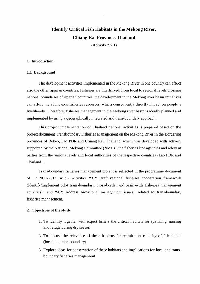
Aage V. Jensen Charity Foundation (2011) reported the process of establishing the
FCZs under the WWF project on Transboundary Conservation of the Mekong Giant Catfish
(Pangasianodon gigas) in Chiang Rai (Thailand) and Bokeo (Lao PDR) Provinces, Mekong
River. These 7 steps processes involve various stakeholders such as: (i) fishers, for gathering
fisheries information; and (ii) village committee, DOF and District Fisheries Officer. Details of
these processes are summarised in Table 2. Fish Conservation Zones in Chiang Khong
established under WWF project was showed in Table 3 and the Map of the Mekong
Ecosystems along the Mekong River in Chiang Khong was showed in Figure 2.
Table 2: Processes of FCZs establishment in Chiang Khong under the WWF project.
Processes Details of processes and involved stakeholders
1) Consensus building Interviews of fishers, women and children to gather
information on capture fisheries management, fishing
gear, fish species and migratory information identify
critical fisheries habitats
2) Drafting regulation Villagers meet to discuss fisheries management and to
draft regulations, provide feedback and revise the
regulations based on feedback
3) Revision of drafting regulation
4) Agreement on revised draft
regulations by local level
stakeholders
5) District approval of aquatic
resources management regulation
The regulations are signed by the village authorities and
presented and approved by DAFO, later District Governor
to allow the village to implement the proposed regulations
6) Public announcement of the
establishment of village regulations
for aquatic resources management
It is usually implemented with an opening ceremony
and via local news media
7) Monitoring and evaluation Identifying problems and important issues of village
aquatic resources management plan for adaptive
management
7
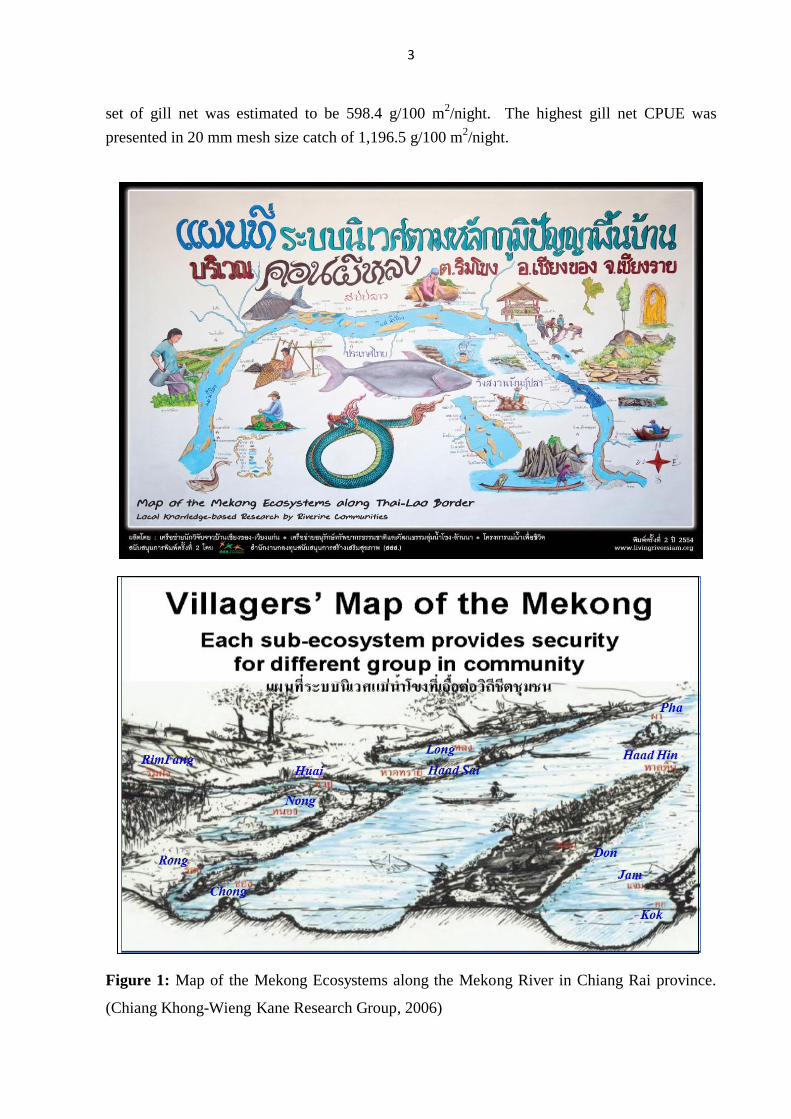
Figure 2: Map of fish conservation zones in Chiang Khong to Wieng Kane area.
Table 3: Fish Conservation Zones (FCZ) in Chiang Khong district established under WWF project.
Established
Date Village Status Size
Depth
(m)
MGC related
Yes or No
11/11/09 Pak Ing Bon FCZ and fisheries
regulation established
300 m
along the
Mekong
8 No
18/4/10 Haad Khai MGC conservation zone
and fisheries regulation
established
300 m
along the
Mekong
12 Yes
25/8/10 Don Tee MGC conservation zone
and fisheries regulation
established
300 m
along the
Mekong
11 Yes
21/10/10 Pak Ing Tai FCZ and fisheries
regulation established
200 m
along the
Mekong
5 No

8
5. Methodology of study
5.1 Study area
All activities under subproject 2.2.1 were conducted at the four target villages and their
monitoring sites nearby the villages (Figure 3) during June 2014 to October 2015. PRA study
and LEK expert interview were applied in the village with local communities and expert fisher.
Also fish gonad development and fish larvae sampling were investigated. The 4 study sites are;
1. Ban Don Tee located in Rim Khong subdistrict, Chiang Khong district
2. Ban Muang Kan located in Rim Khong subdistrict, Chiang Khong district
3. Ban Pak Ing Tai located in Sri Donchai subdistrict, Chiang Khong district
4. Ban Huai Luek located in Muang Yay subdistrict, Wieng Kane district
Figure 3: Map of study sites of 4 target villages in Chiang Rai province, Thailand.
3
4
1
2

9
5.2 Study period and site visit
This project was carried out for data collecting and field survey during June 2014 to
October 2015. The research teams were investigated under the project activities as follows;
Project activities Duration
1. PRA study for resources mapping together with clarify
critical habitats, fishing ground and fishing activities.
July- February 2014
2. LEK interviews for more information on habitats study. July 2014-February 2015
3. Spawning ground validation by investigation on gonad
development of dominant fish species in the 4 target
villages.
July 2014-August 2015
4. Nursing ground validation by fish larvae survey from 2
trips sampling of 14 stations with a 4x30 m of larvae
beach seine net.
October 2014 and June 2015
5. Focus group discussion for rechecking data and
information with local expert fisher.
February 2015
6. Habitat ground truth survey and GPS positioning. May-August 2015
7. Investigation of daily water regime data of the Mekong
river at Chiang Saen station.
July-August 2015
8. Data checking and data handling July-August 2015
9. Data analysis and writing report September-November 2015
5.3 Methods for data collection
In this study, we used the potential tools for identify of critical fish habitats as follows;
1. The PRA study and interview tools with the LEK expert in each 4 villages (Figure 4)
which the steps of work had been done as;
1) Identification of LEK experts: the experts are fishers who are the most
knowledgeable about local fisheries, fishing grounds and critical habitats.
2) Face-to-face interview with LEK experts: The face-to-face interview was
conducted with the LEK experts identified in each village in order to collect and
generate data and information about critical habitats as spawning habitat, nursing
habitat and refuge habitat in the dry season
3) Focus group discussion: focus group discussion with all LEK experts had
conducted in order to validate data and information provided during the research
team and LEK expert were meeting together. Research team had rechecked some
information in order to validate data and information which the team is not sure of
during face-to-face interviews with LEK experts.

10
4) All details of each step of implementation are focusing on the 7 topics as;
Mapping on their village location and other surrounding community that
settlement nearby of both sides of the Mekong River.
Information and location of fishing ground area and fishing gear used.
Information and location of conservation zone in the village area.
Information on rules and agreement of fishing activities in the village.
Information and location of spawning ground in the village area.
Information and location of nursing ground in the village area.
Information and location of refuge of dry season in the village area.
Information about problem and conflict on fisheries activities in the village.
2. Conducted scientific validation of spawning ground by investigation of fish maturity
stage in the 4 target villages. The research teams were further investigated/validated
of the information via site visits to find the evidence by collecting fishes at the sites
for studying gonad development (Figure 5).
3. Conducted scientific validation of the nursing ground in the 4 study areas. The
research team had done the survey to collecting fish larvae and juveniles in identified
nursing habitats from 14 sampling sites along the 4 village area (Figure 6 and 7).
4. Conducted ground truth survey of existing habitats and GPS positioning.
5. Find out the alternative fisheries management options from all available information
i.e. habitats, fisheries activities, conflict and participation of the target communities.
5.4 Data analysis and comparison
For the overall comparison of the fisheries potential in the study area, we analysed and
compared all information from 6 dimensions of 14 topics as follows;
1. Fishing pressure aspect, we used 3 topics to consider as
1) Number of occupation/fulltime fisher in the village,
2) Fishing activities found in the village area, and
3) Demand of fish catch around the village area
2. Spawning opportunity aspect, we used 2 topics to consider as
1) Number of spawning habitats found in the village area, and
2) Number of maturity fish species found in the village area
3. Nursing opportunity aspect, we used 2 topics to consider as
1) Abundance of fish larvae found in the village area, and
2) Number of nursing habitats found in the village area
4. Refuge habitats and conservation zone aspect, we used 2 topics to consider as

11
1) Amount of refuge habitats found in the village area (not include FCZ), and
2) Amount of fish conservation zone in the village area
5. Participation of the community aspect, we used 3 topics to consider as
1) Fisheries activities contribution to the village community,
2) Action of fisheries village committee, and
3) Action of village leader
6. Problem and conflict aspect, we used 2 topics to consider as
1) Illegal fishing found the village area, and
2) Conflict of water resource utilization in the village area
Each topic under the 6 aspects were classified and determined their present situation
under the most appropriate situation of 5 level as; 0 = very poor/low, 1 = poor/low, 2 = fair, 3
= good/high, 4 = very good/high.
Figure 4: PRA study, group discussion with the LEK expert, and face to face expert fisher
interview for investigation of critical fish habitat in the 4 target villages.

12
Figure 5: Validation of spawning ground by investigation of gonad development of dominant
fish species in the 4 target villages during April 2014 to August 2015.
Figure 6: Mapping on all sampling stations of nursing ground survey in the 4 target villages.
13
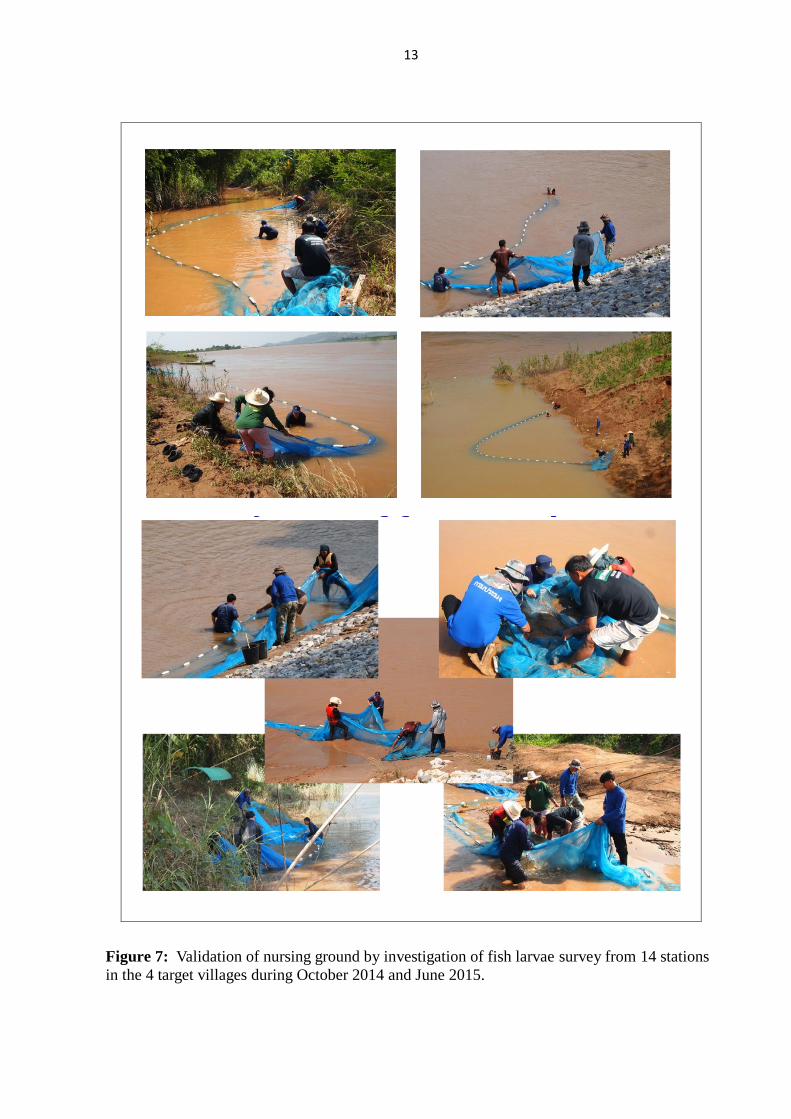
Figure 7: Validation of nursing ground by investigation of fish larvae survey from 14 stations
in the 4 target villages during October 2014 and June 2015.

14
6. Results and discussion
6.1 Characteristic of Mekong mainstream at 4 study sites
6.1.1 River morphology
From our team observation during PRA study and habitat survey we found that the
characteristic of the Mekong mainstream at the 4 targets villages were quite difference together
as showed in Table 4 and Figure 8.
Table 4: The characteristic of the Mekong mainstream at the area of 4 target villages.
Village Characteristic of the Mekong mainstream
1. Ban Don Tee This village located on river bank of the Mekong mainstream about 40
km above of Chiang Khong District. The width of the Mekong river
was narrowed down in their stream where provided a high depth of
river bank in a small hill area. The river was a high velocity than the
other 3 sites and their river substrate consisted of many pebble and
small gravel. Also at downstream location below the village site was
consisted of many small rapids and deep pool.
2. Ban Muang Kan This village located in Mekong mainstream about 25 km above of
Chiang Khong District. The river mainstream in this site was extended
to a quite wide stream with a concave shape. In dry season, the area
below village site had changed to a small shallow lake which connected
to flood area. It was a quite shallow and low of river velocity than the
other 3 sites. The river substrate was a clay soil with short distance of
river bank.
3. Ban Pak Ing Tai This village located in the Mekong mainstream about 15 km below of
Chiang Khong District. The river was flow down with a concave shape
to the east direction with a narrow downstream between two small
mountains. The river bank was quite high. It is also high velocity but
slower than station 1 at Ban Don Tee village.
4. Ban Huai Luek This village located in Mekong mainstream about 40 km below of
Chiang Khong District. The river was expanded to a wide stream river
which shallow river bank than the station 1 and 3. At the downstream
site below this village was composted of a few big rapids and high
depth of deep pool.
15
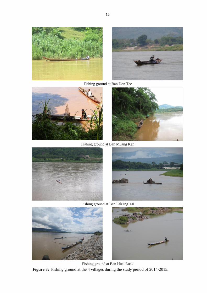
Fishing ground at Ban Don Tee
Fishing ground at Ban Muang Kan
Fishing ground at Ban Pak Ing Tai
Fishing ground at Ban Huai Luek
Figure 8: Fishing ground at the 4 villages during the study period of 2014-2015.

16
6.1.2 Water regime and its fluctuation
From the location of the Mekong mainstream in Chiang Rai province (Figure 9) where
it was located at the middle part of the total length of Mekong River, about 400 m above mean
sea level and 2,200 to 2,300 km far from the river headwater in China. The daily fluctuation of
water regime in this area was observed at Chiang Sean station (Figure 10). It was found that
the high water regime was started from June to November. The rising period of water regime
was estimated around June to September. This period will affect many migratory fish species
that will migrate to searching for their spawning ground. During dry season of the past 4 years,
there was frequency showed a rapidly changing of 1-2 meter of water level in a short period of
3-10 days.
Figure 9: The topography and profile of Mekong mainstream in Chiang Rai province.
Jan Feb Mar Apr May Jun Jul Aug Sep Oct Nov Dec
Figure 10: Daily water regime of Mekong River at Chiang Saen station during 2012-2015.

17
6.2 LEK and information from fisher expert
6.2.1 Fisher profiles
1) Age
We interviewed a total number of 28 fishers in the 4 target villages. The age range of
fishers was between 32 - 65 years old with an average of 48.1±8.2 years. We found that all of
the fishing experience did not much vary with the age of fisher (Table 5 and Figure 11).
2) Education
Most of the fishers graduated from primary school (12 fishers), 9 from secondary
school, 2 from vocational school, and one with no education (Table 5 and Figure 11).
3) Experience in fishing
Fishers had experience in fishing between 12-52 years with an average experience of
29.1±10.3 years. The fisher who has the most experiences was located in Ban Pak Ing Tai,
Chiang Khong District (Table 5 and Figure 11).
Figure 11: All of fisher expert in the 4 target villages who providing fish habitats and fishing
characteristic information in the Mekong mainstream.

18
Table 5: List of fisher name, location and their experiences of the expert fisher from 4 target
villages of the Mekong mainstream in Chiang Rai province.
Name Location Age
(year) Education
Experienced
(year)
Mr. Sakorn Sittikaew Ban Don Tee 55 No education 37
Mr. Somporn Sribunreang Ban Don Tee 53 Secondary school 15
Mr. Boonchiey Boomrungkaen Ban Don Tee - - -
Mr. La Srisawat Ban Don Tee 55 Primary School 43
Mr. Thongphun Srisawat Ban Don Tee 32 Primary School 12
Mr. Sakorn Nuntharuk Ban Don Tee - - -
Mr. Jun Srisudawan Ban Don Tee - - -
Mr. Boonchom Boomrungkaen Ban Don Tee 41 Primary School 12
Mr. Wandee Srisudawan Ban Don Tee 68 Primary School 40
Mr. Winai Inkaew Ban Muang Kan 49 Secondary school 36
Mr. Nakhon Punthayom Ban Muang Kan 41 Vocational Certificate 25
Mr. Srithai Wonggoat Ban Muang Kan 48 Primary School 18
Mr. Peng Ban Muang Kan - - -
Mr. Somwang Seansarn Ban Pak Ing Tai 38 Vocational Certificate 15
Mr. Pornchai Buddee Ban Pak Ing Tai 57 Primary School 40
Mr. Nutthaphon Boontri Ban Pak Ing Tai 46 Primary School 33
Mr. Somnuek Lerttakun Ban Pak Ing Tai 44 Secondary school 32
Mr. Aekarat Buddee Ban Pak Ing Tai 47 Secondary school 30
Mr. Buntham Buddee Ban Pak Ing Tai 47 Primary School 29
Mr. Phomma Srida Ban Pak Ing Tai 65 Primary School 52
Mr. Somsak Buddee Ban Pak Ing Tai 45 Secondary school 30
Mr. Boonphun Budkai Ban Pak Ing Tai 45 Secondary school 20
Mr. Insom Wiset Ban Huai Luek 50 Primary School 36
Mr. Somboon Kammawong Ban Huai Luek 38 Secondary school 22
Mr. Thongwai Buaraidet Ban Huai Luek 48 Secondary school 30
Mr. Prasit Inthawong Ban Huai Luek 41 Secondary school 30
Mr. Suport pongsawat Ban Huai Luek 50 Primary School 36
Mr. Boonme Weankaew Ban Huai Luek 51 Primary School 25
Average - 48.08 - 29.08
S.D. - 8.22 - 10.34

19
6.2.2 Resources mapping and habitats information
According to the PRA study and LEK expert interview from 4 target villages, the result
of the study and resources mapping are shown in the Table 6-7 and Figure 12-16.
This is a result of resource mapping at
Ban Don Tee village where located in
Mekong mainstream about 40 km above
Chiang Khong district. At both sides of
this area were located of 5 communities
as; 2 villages at Thai side and 3 villages
at Lao side.
This is a result of resource mapping at
Ban Muang Kan village where located in
Mekong mainstream about 25 km above
Chiang Khong district. At both sides of
this area were located of 5 communities;
2 villages at Thai side and 3 villages at Lao side.
This is a result of resource mapping at
Ban Pak Ing Tai village where located in
Mekong mainstream about 15 km below
Chiang Khong district. At both sides of
this area were located of 4 communities;
3 villages at Thai side and 1 village at
Lao side.
This is a result of resource mapping at
Ban Huai Luek village where located in
Mekong mainstream about 40 km below
Chiang Khong district. At both sides of
this area were located of 4 communities;
2 villages at Thai side and 2 villages at
Lao side.
Figure 12: Information on resources mapping and habitats of 4 targets villages along the
Mekong mainstream.

20
Table 6: Summarize information derived from PRA study and expert fisher interview at 4 target villages.
Item 1. Ban Don Tee 2. Ban Muang Kan 3. Ban Pak Ing Tai 4. Ban Huai Luek
Village location Village No. 3,
Rim Khong subdistrict,
Chiang Khong district,
Chiang Rai province.
Village No. 2,
Rim Khong subdistrict,
Chiang Khong district,
Chiang Rai province.
Village No. 16,
Sri Donchai subdistrict,
Chiang Khong district,
Chiang Rai province.
Village No. 4,
Muang Yay subdistrict,
Wieng Kane district,
Chiang Rai province.
Surrounding village
community
1. Ban Don Tee
2. Ban Haad Baai
3. Ban Nam Koeng Kao (Lao side)
4. Ban Nam Koeng Mai (Lao side)
5. Ban Sri Donxai (Lao side)
1. Ban Muang Kan
2. Ban Rai Charoen
3. Ban Nam Ngaw (Lao side)
4. Ban Huai Tak (Lao side)
5. Ban Huai Mun (Lao side)
1. Ban Pak Ing Tai
2. Ban Pak Ing
3. Ban Don Mahawan
4. Ban Don Chan (Lao side)
1. Ban Huai Luek 1
2. Ban Huai Luek 2
3. Ban Kang (Lao side)
4. Ban Kok Laung (Lao side)
Household number 168 101 50 133
Total fisher household 48 42 50 83
Occupation FHH 20 11 29 20
Subsistence FHH 28 31 21 63
Percentage of all FHH 28.57 % 41.58 % 100 % 62.41 %
Percentage of Occ. FHH 14.29 % 10.89 % 58.00 % 15.04 %
Fishing ground 1. Mekong mainstream in front of
village and above village for
drifting gillnet and hook longline
2. Along river bank for stationary
gillnet, multiple hook longline,
pole hook and cast net
3. Rapids area below village
1. Mekong mainstream about 500 m
long for drifting gillnet 2 area
2. Along river bank for stationary
gillnet, pole hook and cast net
3. Nong Mae Maay at dry season
Depth 1.5 m 1.5 km long
4. Rapids area above and below
village
1. Mainstream along river bank
above village about 500 m long
2. Mainstream along river bank
below village about 800 m long
3. Mainstream Lao side 300 m long
4. In the Ing River 1,000 m long
5. Nong Ing Yai (46 rai)
6. Rapids area below village
7. Along river bank
1. Kok Laung - Kang Kon Khum
about 100 m long
2. Kang Pha Dai
2. Mainstream in front of village about
500 m long
5. Mainstream below village about
300 m long
6. Rapids and deep pool area

21
Item 1. Ban Don Tee 2. Ban Muang Kan 3. Ban Pak Ing Tai 4. Ban Huai Luek
Fishing gear used
1. Drifting gillnet 2 layers net
2. Stationary gillnet
3. Pole hook
4. Cast net
5. Hook longline
6. Drop door trap
7. Multiple hook longline
1. Drifting gillnet 2 layers net
2. Stationary gillnet
3. Pole hook
4. Cast net
5. Hook longline
6. Bamboo tube eel trap
7. Barbed rattan trap
1. Drifting gillnet 2-3 layers net
2. Stationary gillnet
3. Hook longline
4. Cast net
5. Drop door trap
6. Hand life net
7. Scooping net
1. Drifting gillnet 2 layers net
2. Stationary gillnet
3. Hook longline
4. Cast net
5. Drop door trap
6. Pole hook
7. Hand push net
Fish conservation zone
(FCZ)
1. Kok Ma Tao / Kok Tangmo
2. Kok Pha Lat
1. Kok Pha Khee = 1 rai
2. Pha Pra = 1 km
3. Haad near village = 300 m
1. Ing River = 200 m
2. Kwan Wat Doy Ya Mon =
300 m
3. Ban Don Chan = 300 m
1. Haad near village = 300 m
Number of Village
Fisheries committee 6 member 12 member 13 member 12 member
Fishing rule of the
village
1. Common fishing ground freely
access for Thai & Lao fisher.
2. On common fishing ground has
to go in order as one by one.
3. Prohibited fishing in FCZ, if
anyone violates the agreement
will be fined for 2,000 Baht.
4. All fisher has to participate in
fishing ground cleaning day.
1. Common fishing ground freely
access for Thai & Lao fisher.
2. On common fishing ground has
to go in order as one by one.
3. Prohibited fishing in FCZ, if
anyone violates the agreement
will be fined for 2,000 Baht.
4. All fisher has to participate in
fishing ground cleaning day.
1. Mekong mainstream is freely
access both sides Thai and Lao.
2. In the Ing River only allow for
Thai side.
3. If Ban Don Chan go across the
river to Thai side have to pay
for the fee for 500 Baht/year .
4. Nong Ing Yai is also permitted
for the 2 Pak Ing villagers.
5. Prohibited fishing in FCZ, if
anyone violates the agreement
will be fined for 2,000 Baht.
6. All fisher has to participate in
fishing ground cleaning day.
1. Kok Luang is freely access for
both sides.
2. Other Loa side is for Lao fisher.
3. Other Thai side for Thai fisher.
4. Prohibited fishing in FCZ, if
anyone violates the agreement
will be fined for 1,500 Baht.
5. All fisher has to participate in
fishing ground cleaning day, if
do not joint have to pay 300
Baht.

22
Table 7: Summarizes of fishing activities and gear used from PRA study and expert fisher interview at 4 target villages.
Type of gear
Gear size Dominant fish species
caught
Gear used (month)
Mesh sizes
/hook size
Length
(m.)
Depth
(m.) 1 2 3 4 5 6 7 8 9 10 11 12
Ban Don Tee village
1. Drifting gillnet-2 layers net 5, 14 cm 80 1.2 Hemibagrus filamentus,
Hemibagrus nemurus,
Hemibagrus sp.,
Morulius chrysophekadion,
Cosmochilus harmandi,
Micronema micronema,
Hemisilurus mekongensis,
Cyprinus carpio,
Wallagonia sp.,
Bagarius sp.,
Mystus sp.,
Chitala ornata
X X X X
2. Stationary gillnet 6, 18 cm 15 - 20 4 X X X X X X X X X X X X
3. Hook longline # 6 - - X X X X
4. Cast net 6 cm - 4 X X X X X X X
5. Drop door trap - 1-1.5 50 cm X X X X X X X X X X X X
6. Pole hook # 6 - - X X X X
7. Multiple hook longline # 8 - - X X X X X X X X X X X X
Ban Muang Kan Village
1. Drifting gillnet-1 layers net 5 cm 200 1.2 - 1.3 Hemibagrus filamentus,
Hemibagrus nemurus,
Hemibagrus sp.,
Micronema micronema,
Hemisilurus mekongensis,
Wallagonia sp.,
Bagarius sp.,
Mystus sp.,
Henicorhynchus sp., Paralaubuca riveroi, Pangasius macronema, Channa striata, Monopterus albus, Barbodes gonionotus
X X X X X
2. Drifting gillnet-2 layers net 2-4, 5 cm 7, 12 cm
100 300
1.2 1.7
X X X X X
3. Stationary gillnet 3, 4 cm 30 1.5 X X X X
4. Pole hook # 5, # 6 - - X X X X X
5. Cast net 3.5 - 6 cm
- 3 - 4 X X X X X X
6. Drop door trap - 1-1.5 50 cm X X X X X X X X
7. Bamboo tube eel trap - - - X X X X
8. Hook longline - - -

23
Type of gear
Gear size Dominant fish species
caught
Gear used (month)
Mesh sizes
/hook size
Length
(m.)
Depth
(m.) 1 2 3 4 5 6 7 8 9 10 11 12
Ban Pak Ing Tai Village Hemibagrus filamentus,
Hemibagrus nemurus,
Hemibagrus sp.,
Morulius chrysophekadion,
Cosmochilus harmandi,
Micronema micronema,
Hemisilurus mekongensis,
Cyprinus carpio,
Wallagonia sp.,
Bagarius sp.,
Mystus sp., Chitala ornate, Henicorhynchus spp., Paralaubuca riveroi, Pangasius macronema, Channa striata Macrochirichthys macrochirus Pangasius conchophilus Kryptopterus cheveyi
1. Drifting gillnet-1 layers net 20 cm 200 1.9 X X X X X
2. Drifting gillnet-2 layers net 8-10, 16 200 X X X X X
3. Drifting gillnet-3 layers net 6-7,10,18 200 1.5-1.8 X X X X X
4. Stationary gillnet 16 150 2 - 3 X
5. Hook longline # 7 - - X X X X X X X X X X X X
6. Cast net 6 cm - 4 X
7. Drop door trap - 1-1.5 50 cm X X X X X X X X X X X X
8. Hand lift net - - - X X X
9. Scoop net - - - X X X
Ban Huai Luek
1. Drifting gillnet-1 layers net 18 cm 200-300 1.5 Hemibagrus filamentus,
Hemibagrus nemurus,
Hemibagrus sp.,
Morulius chrysophekadion,
Cosmochilus harmandi,
Micronema micronema,
Hemisilurus mekongensis,
Wallagonia sp.,
Bagarius sp.,
Mystus sp.,
Chitala ornata
X X X X X
2. Drifting gillnet-2 layers net 8, 10, 16, 18, 20 cm
200-500 1.2-1.5 X X X X X X X
3. Stationary gillnet 5-12, 6, 8, 14, 18 cm
10, 60 4 X X X X X X X X X X X X
4. Hook longline # 6 - - X X X X X X X X X X X X
5. Cast net 3-6 cm - 4.0 X X X X
6. Drop door trap 6 1-1.5 50 cm X X X X X X X X X X X X
7. Pole hook # 6 - - X X X X X X X X X X X X
8. Hand push net - 2 - X X

24
1. Surrounding village 2. Fishing ground
3. Fish conservation zone 4. Fishing gear used
5. Fishing agrement / rules 6. Fish spawning ground
7. Fish nursing ground 8. Fish refuge area
Figure 13: Mapping resources of community, fishing ground and habitats around Ban Don Tee.

25
1. Surrounding village 2. Fishing ground
3. Fish conservation zone 4. Fishing gear used
5. Fishing agrement / rules 6. Fish spawning ground
7. Fish nursing ground 8. Fish refuge area
Figure 14: Mapping resources of community, fishing ground and habitats around Ban Muang Kan.

26
1. Surrounding village 2. Fishing ground
3. Fish conservation zone 4. Fishing gear used
5. Fishing agrement / rules 6. Fish spawning ground
7. Fish nursing ground 8. Fish refuge area
Figure 15: Mapping resources of community, fishing ground and habitats around Ban Pak Ing Tai.

27
1. Surrounding village 2. Fishing ground
3. Fish conservation zone 4. Fishing gear used
5. Fishing agrement / rules 6. Fish spawning ground
7. Fish nursing ground 8. Fish refuge area
Figure 16: Mapping resources of community, fishing ground and habitats around Ban Huai Luek.

28
6.2.3 Critical habitats found
From the PRA study and LEK expert interview at the 4 target villages, our team had
received all information about the critical fish habitats in the targets village as showed in the
Table 8 and also picture of those conservation zones in Figure 17.
Table 8: List of critical fish habitats found in the Mekong mainstream and their tributaries
from 4 target villages.
Village Name of fish habitats found in the surrounding area of 4 target villages
Spawning ground Nursing ground Refuge in dry season
Ban Don Tee 1. FCZ at Kok Ma Tao /
Kok Tangmo
2. Kok Pha Lat
Fisher said do not have
nursing ground,
Due to the narrow stream
and strong velocity of
Mekong river in this area
1. Kok Pha Yang (2 rai)
2. Chong Pha Gub
3. FCZ at Kok Ma Tao
4. Kok Pha Lat
Ban Muang Kan 1. Sand beach in the
Mekong River above the
village where more
abundance of aquatic
macrophytes
2. Haad Mae Maay (about
1.5 km long)
1. Kwan or small basin in
the Mekong River at
below the village site
2. Don or sand beach in
the Mekong River
above the village site
1. Kok Pha Sian 1 km.
2. Kok Sak 1 rai
3. Kok Pha Khee 1 rai
4. Pha Kan Tung
5. Kok Pha Yead
6. Kang Huai Tone
7. Haad Chan
8. Long Pha Wua 4 rai
9. Deep pool Pha Thak
Ban Pak Ing Tai 1. FCZ in the Ing River
2. At river mouth of the Ing
river
3. FCZ Wat Doy Ya Mon
1. In the Ing River
2. At Rapids area
1. Wang Namwon area 4 rai
2. Wang Pha Ngok area 2.5
rai (Lao side)
3. Wang Suan Kha
4. Wang Takean Lek
5. Wang Takean Yai
Ban Huai Luek 1. At Teen river (Lao side)
about 2 km long
2. Kok Sala area about
2-3 rai
1. Kang Pha Dai area about
2-3 rai
2. Kang Kon Khum
3. Kok Song Hong
4. FCZ in front of village

29
Kok Ma Tao FCZ, Ban Don Tee Kok Pha Lat, Ban Don Tee
Pha Khee FCZ, Ban Muang Kan Pha Pra FCZ(Lao side), Ban Muang Kan
Pak Ing FCZ, Ban Pak Ing Tai Doy Ya Mon FCZ, Ban Pak Ing Tai
Ta Ruae FCZ, Ban Huai Luek FCZ at Immagration, Ban Huai Luek
Figure 17: Pictures of fish conservation zone in the Mekong River of those 4 target villages.

30
Kok Ma Tao, Ban Don Tee Kok Pha Lat, Ban Don Tee
Haad Mae Maay, Ban Muang Kan FCZ at in front of village, Ban Muang Kan
Ing River, Ban Pak Ing Tai Kwan Wat Doy Ya Mon,
Ban Pak Ing Tai
Teen River (Lao side), Ban Huai Luek Kang Pha Dai, Ban Huai Luek
Figure 18: Pictures of fish spawning habitats in Mekong mainstream, information from
interviewing of fisher expert in 4 target villages.
31
Chong Pha Gub, Ban Don Tee Kok Pha Yang, Ban Don Tee
Kok Pha Thak, Ban Muang Kan Kok Pha Khee, Ban Muang Kan
Kwan wang Namwon (whirl pool),
Ban Pak Ing Tai
Wang Pha Ngok, Ban Pak Ing Tai
Kang Pha Dai, Ban Huai Lyek Kang Kon Khum, Ban Huai Luek
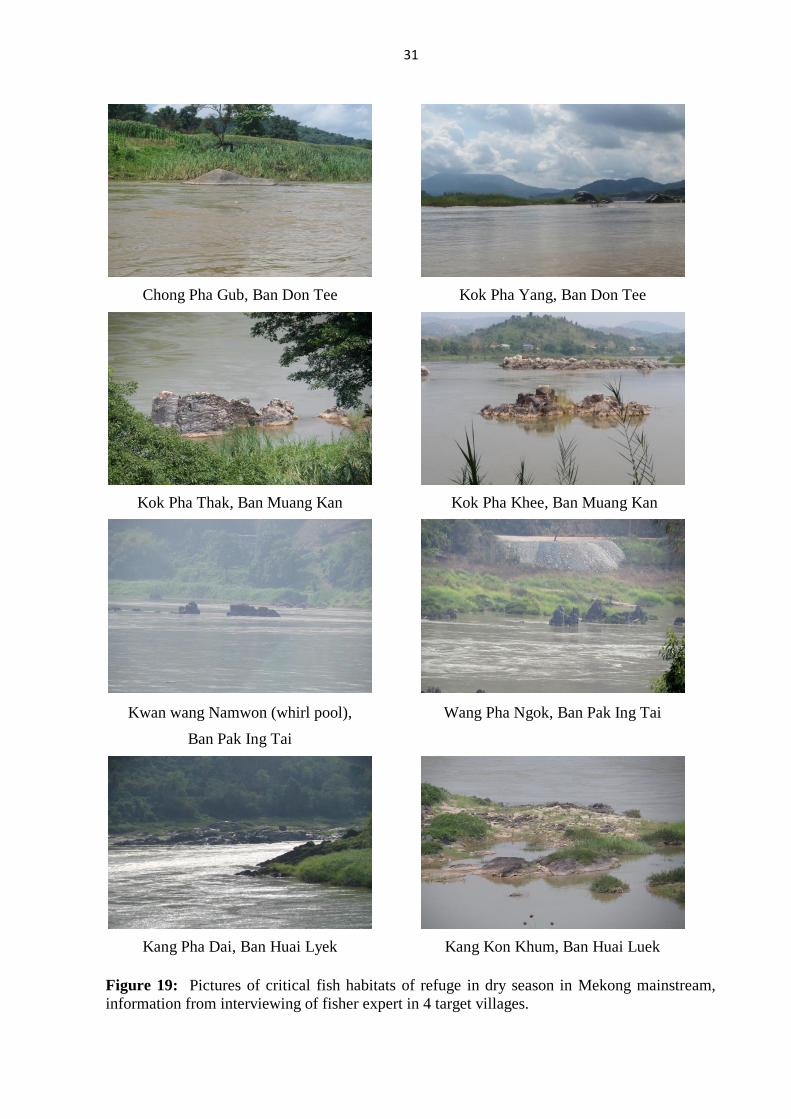
Figure 19: Pictures of critical fish habitats of refuge in dry season in Mekong mainstream,
information from interviewing of fisher expert in 4 target villages.

32
6.3 Scientific validation of spawning habitat
From our team study by sampling dominant fish at the landing site of 4 target villages
for gonad development investigation during July 2014 to August 2015. We collected about
237 samples from 27 species (Table 9 and Figure 20) and found that all dominant fish species
can be found in the Mekong mainstream in this 4 target village but may be different in their
abundance. At Ban Don Tee where located the most upper part of study area still found many
fish species. This result also confirmed that the fish bloodstocks and ready to spawn fish has
achieved to this place for search their spawning ground.
Table 9: Information from investigation of gonad development of dominant species at 4 target village during July 2014 - August 2015.
Species
Number of fish sample
1. Ban
Don Tee
2. Ban
Muang Kan
3. Ban
Pak Ing Tai
4. Ban
Huai Luek
Early stage
Ready to spawn
Early stage
Ready to spawn
Early stage
Ready to spawn
Early stage
Ready to spawn
Hemibagrus sp. 13 9 - - 1 18 3 3
Hemibagrus filamentus - - - - - - 3 1
Barbodes altus 2 - - - 1 - - -
Puntioplites proctozysron 8 - - - 3 - - -
Morulius chrysophekadion 13 7 - - 2 9 - 8
Cirrhinus molitorella - - - - 1 1 - -
Mystus singaringan - - - - - 3 - -
Wallagonia attu - - 1 - - - 2 3
Bagarius yarrelli 9 4 - - 1 - 2 -
Poropuntius laoensis 1 - - - 1 - - -
Dangila siamensis 3 - - - - - - -
Hemisilurus mekongensis - - 3 - 1 - - -
Micronema micronema - - - - 16 - - -
Cosmochilus harmandi - 2 - - - 1 - 6
Hypsibarbus verneyi - 1 - - - - - -
Barbodes gonionotus 1 1 - - - - - -
Hypsibarbus gerdgeri - - - - 2 - - -
Cyprinus rubrofuscus - - - - - - - 1
Pangasius conchophilus - - - - 1 - - -
Pangasius bocourti 1 - - - - - - -
Osteochilus microcephalus - 1 - - - - - -
Pangasius macronema 5 1 - - 4 24 - -
Mystacoleucus marginatus - - - - 9 2 - -
Pristolepis fasciatus - 2 - - - - - -
Syncrossus helodes - - - - 2 - - -
Syncrossus beaufortii 1 - - - - - - -
Bangana pierei 1 - - - - - - -
Total number (237 ind.)
60 28 4 - 48 58 13 26
Total species (27 species)
12 9 2 - 14 7 4 6

33
Investigation of gonad development of dominant fish species at Ban Don Tee
Investigation of gonad development of dominant fish species at Ban Muang Kan
Investigation of gonad development of dominant fish species at Ban Pak Ing Tai
Investigation of gonad development of dominant fish species at Ban Huai Luek
Figure 20: Pictures of activities of gonad development investigation in the 4 target villages.
34
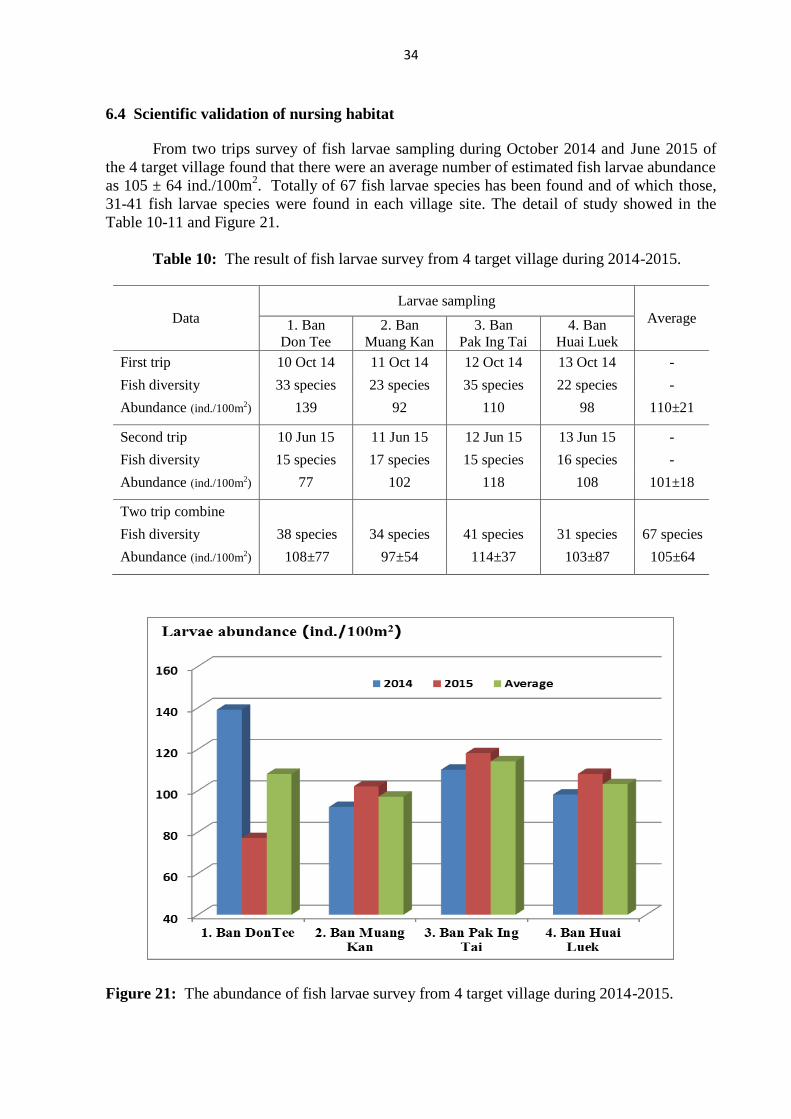
6.4 Scientific validation of nursing habitat
From two trips survey of fish larvae sampling during October 2014 and June 2015 of
the 4 target village found that there were an average number of estimated fish larvae abundance
as 105 ± 64 ind./100m2. Totally of 67 fish larvae species has been found and of which those,
31-41 fish larvae species were found in each village site. The detail of study showed in the
Table 10-11 and Figure 21.
Table 10: The result of fish larvae survey from 4 target village during 2014-2015.
Data
Larvae sampling
Average 1. Ban
Don Tee
2. Ban
Muang Kan
3. Ban
Pak Ing Tai
4. Ban
Huai Luek
First trip 10 Oct 14 11 Oct 14 12 Oct 14 13 Oct 14 -
Fish diversity 33 species 23 species 35 species 22 species -
Abundance (ind./100m2) 139 92 110 98 110±21 1.
Second trip 10 Jun 15 11 Jun 15 12 Jun 15 13 Jun 15 -
Fish diversity 15 species 17 species 15 species 16 species -
Abundance (ind./100m2) 77 102 118 108 101±18 2.
Two trip combine 3.
Fish diversity 38 species 34 species 41 species 31 species 67 species
Abundance (ind./100m2) 108±77 97±54 114±37 103±87 105±64 4.
Figure 21: The abundance of fish larvae survey from 4 target village during 2014-2015.

35
Table 11: Species and number of fish larvae (ind./100m2)found from 4 target village during the survey of August 2014 and June 2015.
No Scientific name
1. Ban Don Tee 2. Ban Muang Kan 3. Ban Pak Ing Tai 4. Ban Huai Luek
St 1 St 2 St 3 St 4 St 5 St 6 St 7 St 8 St 9 St 10 St 11 St 12 St 13 St 14
Oct Jun Oct Jun Oct Jun Oct Jun Oct Jun Oct Jun Oct Jun Oct Jun Oct Jun Oct Jun Oct Jun Oct Jun Oct Jun Oct Jun
1 Family Clupeidae
1 Clupeichthys aesarnensis Wongratana, 1983 - - 1 - - - - - - - - - - - - 27 - 55 - - - - - - - 3 - 3
2 Family Cyprinidae
2 Esomus longimanus (Lunel, 1881) - - - - - - - - - - - - - - - - - - - - - - - - - 8 - -
3 Esomus metallicus Ahl, 1923 - - 18 - - - 2 - - - - - 1 - 10 - 6 - - - 1 - - - 13 - - -
4 Garra cambodgiensis (Tirant, 1884) - - - - 8 - - - - - - - - - - - - - - - - - - - - - - -
5 Opsarius koratensis (Smith, 1931) - - 1 5 3 3 - 15 - 3 - - 1 28 3 - 1 5 - 5 - - 1 5 - - - 5
6 Raiamas guttatus (Day, 1870) 1 50 - 25 2 15 - 28 - 3 - - - - - 10 1 - - 10 1 5 - - - 3 - 3
7 Rasbora borapetensis Smith, 1934 - - - - - - - - - - - - - - - - - - - - - - - - - - 2 -
8 Rasbora dusonensis (Bleeker, 1851) 8 - 23 - 3 - - - - - - - 1 - - - 3 - - - 2 - 5 - - - - -
9 Rasbora sp.1 - - - - - - - - - - - - - - 3 - - - - - - - - - - - - -
10 Brachydanio albolineatus (Blyth, 1860) - - - - - - - - - - - - - - 8 - - - - - - - - - - - - -
11 Crossocheilus reticulatus (Fowler, 1934) - - 3 - - - - - - - - - - - - - - - - - - - - - - - - -
12 Labeo chrysophekadion (Bleeker, 1850) - - - - - - - - - - - - - - - - 1 - 3 - - - - - - - 2 -
13 Labiobarbus spilopleura Smith, 1934 - - 3 - - - 2 - - - - - 4 - - - 1 - - - - - - - 3 - 2 -
14 Lobocheilos delacouri (Pellegrin and Fang, 1940) - - - - - - - - - - - - - - - - - - 3 - 1 - 1 - - - - -
15 Puntius binotatus (Valenciennes, 1842) - - - - - - - - - - - - - - 3 - - - - - - - - - - - - -
16 Puntius brevis (Bleeker, 1850) - - - - 1 - 3 - - - - - - - - - 1 - - - - - 1 5 - 3 - -
17 Puntius orphoides (Valenciennes, 1842) - - 1 - - - - - - - - - - - - - - - - - 1 - - - - - - -
18 Puntigrus partipentazona (Fowler, 1934) - - - - - - - - - - - - - - - - 1 - - - - - - - - - - -
19 Barbonymus altus (Günther, 1868) - - 1 - - - - - - - - - - - - - - - - - - - - - - - - -
20 Barbonymus gonionotus (Bleeker, 1850) 3 - - - - 3 - 10 - 8 - - - 15 3 - 1 - - - 1 - - 20 - - - -
21 Cyclocheilichthys apogon (Valenciennes, 1842) - - 39 - - - 28 - 2 - - - 7 - - - 10 - - - - - 23 - 3 - - -
22 Cyclocheilichthys armatus (Valenciennes, 1842) - - - - - - - - - 17 - - - - - - - - - - - - - - - - - -
23 Cyclocheilichthys sp.1 - - - - - - - - - - - - - - 3 8 - - - - - - - - - - - -
24 Discherodontus ashmeadi (Fowler, 1937) - - - - - - - - - - - - - - - - - - - - - - - - 3 - - -
25 Epalzeorhynchos frenatus (Fowler, 1934) - - - - - - - - - - - - - - - - - - 5 - - - - - - - - -
26 Henicorhynchus caudimaculatus
(Fowler,1934)
- 7 - - - 10 - - - 5 - 13 - - - 7 2 - - - - - - - - 48 2 103
27 Henicorhynchus siamensis (Valenciennes, 1842) - - - - - - 3 - - - - - - - - - - - - - - - - - - - - -
28 Henicorhynchus sp.1 - - - - - - - - - - - - - - - 15 - - - - - - - - - - - -

36
No Scientific name
1. Ban Don Tee 2. Ban Muang Kan 3. Ban Pak Ing Tai 4. Ban Huai Luek
St 1 St 2 St 3 St 4 St 5 St 6 St 7 St 8 St 9 St 10 St 11 St 12 St 13 St 14
Oct Jun Oct Jun Oct Jun Oct Jun Oct Jun Oct Jun Oct Jun Oct Jun Oct Jun Oct Jun Oct Jun Oct Jun Oct Jun Oct Jun
29 Luciosoma bleekeri Steindachner, 1878 - - 1 - 2 - - - 3 - - - - - - - - - - - - - - - - - - -
30 Mystacoleucus atridorsalis Fowler, 1937 10 53 3 - - - - 5 - - - - - - - - - 3 - - - - - - 50 13 - -
31 Mystacoleucus greenwayi Pellegrin&Fang, 1940 71 - 28 10 24 25 8 - 34 - 66 30 56 - 58
5
37 - 15 - - 3 - 32 25 128 18 4 -
32 Mystacoleucus marginatus (Valenciennes, 1842) - 5 - - - - - - - - - - - 30 - 43 - - - - - - - - - 13 - 43
33 Parachela siamensis (Günther, 1868) - - 3 - - - - - - - - - - - - - - - - - - - - - - - - -
34 Paralaubuca barroni (Fowler, 1934) - - 1 - - - - - - - 6 - 15 45 - - 8 - - - - 2 - - 10 - 2 -
35 Paralaubuca harmandi Sauvage, 1883 - - - 5 - - - - - - - - - - - - - - - - - - - - - - - -
36 Puntioplites proctozystron (Bleeker, 1865) - - 33 - - - - - - - - - - - 3 - - - - - - - 7 - 13 - - -
37 Sikukia gudgeri (Smith, 1934) - - - - - - - - - - - - - - 10 - - - - - - - 1 - 28 - - -
38 Thynnichthys thynnoides (Bleeker, 1852) - - - - - - - - - - - - - - - - 13 5 2 - - - - - - - - -
3 Family Gyrinocheilidae
39 Gyrinocheilus aymonieri (Tirant, 1883) - - 1 - - - - - - - - - - - - - - - - - - - - - - - - -
4 Family Cobitidae
40 Acanthopsis sp.1 - - - - - - - - - - - - 15 5 3 - 1 - 8 - - - - - - - - -
41 Lepidocephalichthys berdmorei
(Blyth,1860)
- - - - 1 - - - - - - - - - - - - - - - - - - - - - - -
42 Lepidocephalichthys hasselti (Valenciennes, 1846) - - - - - - - - - - - - - - - - - - - 3 - - - - - - - -
43 Pangio oblonga (Valenciennes, 1846) - - - - - - - - - - - - - - 3 - - - - - - - - - - - - -
5 Family Balitoridae
44 Nemacheilus binotatus Smith 1933. - - - - 3 - - - - - - - - - - - - - - - - - - - - - - -
45 Nemacheilus pallidus Kottelat, 1990 - - - - - - - - - - - - - - - - - - 2 - - - - - - - - -
46 Balitora sp. - - - - - 3 - - - - - - - - - - - - - - - - - - - - - -
47 Homaloptera sp. - - - - - - - - - - 2 - - - - - - - - - - - - - - - - -
6 Family Sisoridae
48 Bagarius yarrelli (Sykes, 1839) - - - - - - - - 1 - - - - - - - - - - - - - - - - - - -
7 Family Loricariidae
49 Pterygoplichthys pardalis (Castelnau, 1855) - - - - - - - - - - - - - - - - - - - - - - - 3 - - - -
8 Family Siluridae
50 Kryptopterus cryptopterus (Bleeker, 1851) - - 43 - - - 2 - - - - - 8 - - - - - - - - - - - 3 - 10 -
9 Family Schilbeidae
51 Laides longibarbis (Fowler, 1934) - - - - - - - - - - - - 8 - - - - - 2 - - - - - - - 14 -
10 Family Bagridae
52 Hemibagrus filamentus (Fang & Chaux, 1949) - - 25 - 1 - - - 3 - - - - - 3 - 1 - 3 - 1 - - - 3 - - -

37
No Scientific name
1. Ban Don Tee 2. Ban Muang Kan 3. Ban Pak Ing Tai 4. Ban Huai Luek
St 1 St 2 St 3 St 4 St 5 St 6 St 7 St 8 St 9 St 10 St 11 St 12 St 13 St 14
Oct Jun Oct Jun Oct Jun Oct Jun Oct Jun Oct Jun Oct Jun Oct Jun Oct Jun Oct Jun Oct Jun Oct Jun Oct Jun Oct Jun
11 Family Sundasalangidae
53 Sundasalanx mekongensis Britz & Kottelat, 1999 9 2 11 5 6 3 8 115 - 2 - - 8 - - 2 18 43 62 55 - - 3 20 3 5 - -
12 Family Phallostethidae
54 Phenacostethus smithi Myers, 1928 - - 1 - - - - - - - - - 1 - - - 1 - 2 - - - - - - - - -
13 Family Hemiramphidae
55 Dermogenys siamensis Fowler, 1934 - - - - - - - - - - - - - 3 - - - - - - - - - - - - - -
14 Family Belonidae
56 Xenentodon cancila (Hamilton, 1822) - 2 - - - - - 10 - - - - - 5 - - - 3 - - - - 3 - - - - -
15 Family Synbranchidae
57 Monopterus albus (Zuiew, 1793) - - - - - - - - - - - - 1 - - - - - - - - - - - - - - -
16 Family Mastacembelidae
58 Macrognathus siamensis (Günther, 1861) - - - - - - - 3 - - - - - - - - - - - - - - - - - - - -
59 Mastacembelus favus Hora, 1924 - - - - 1 - - - - - - - 1 - - - - - - - - - - - - - - -
17 Family Ambassidae
60 Parambassis apogonoides (Bleeker, 1851) - - - - - - 11 - 2 - - - - - - - 2 - - - - - - - - - - -
61 Parambassis siamensis (Fowler, 1937) 1 - 8 - 1 - - 5 - - - - - - 3 - - - - - - - - 5 - - - -
18 Family Nandidae
62 Pristolepis fasciata (Bleeker, 1851) - - 3 - - - 2 - - - - - - - - - 1 - - - - - - - - - - -
19 Family Cichlidae
63 Oreochromis niloticus (Linnaeus, 1758) - - - - 1 - - - - - - - - - - - - - - - - - - 3 - - - -
20 Family Gobiidae
64 Gobiopterus chuno (Hamilton 1822) 1 - - - - - - - - 2 - - - - 43 - 2 - - 3 - - 4 55 - 3 - 5
65 Papuligobius ocellatus (Fowler, 1937) - - 3 - - - - - - 2 2 - 1 - 3 - - - - - - - - - - - - -
21 Family Channidae
66 Channa gachua (Hamilton, 1822) 1 - - - - - - - - - - - - - - - - - - - - - - - - - - -
22 Family Tetraodontidae
67 Pao brevirostris (Bleeker, 1850) - - - - - - - - - - - - - - - - - - - - - - - 3 - - - -
Sum 110
5
119 254 50 57 62 134
191 45 42 76 43 113 131 160
149 75 129 94
76 11 7 81 144 260
117 38 162
Average 108±77 97±54 114±37 103±86

38
6.5 Habitat ground truth and GPS positioning
The result of on ground truth survey and GPS habitats positioning was showed in Table 12.
Table 12: The GPS positioning of fish conservation zone in the Mekong River of those 4 target villages.
Categories Rechecking result at the village community
1. Ban Don Tee 2.Ban Muang Kan 3. Ban Pak Ing Tai 4. Ban Huai Luek
Spawning
Habitats
Name and
location GPS
Kok Ma Tao
N 2023941 E 10016038
Haad Mae Maay
N 2021229 E 10022066
Ing River
N 2012348 E 10027024
Teen River (Lao side)
N 2010397 E 10033351
Spawning
and nursing
Habitats
Name and
location GPS
Kok Pha Lat
N 2023927 E 10016047
Kok Pha Thak
N 2022904 E 10020959
Wang Namwon
N 2011839 E 10027342
Kang Pha Dai
N 2010094 E 10034480
Nursing and
refuge in dry
season Habitats
Name and
location GPS
Chong Pha Gub
N 2023858 E 10017313
Kok Pha Khee
N 2022885 E 10020964
FCZ at Wat Doy Ya Mon
N 2011789 E 10027407
FCZ at Ban Huai Luek
N 2009587 E 10032507
Refuge in dry
season
Habitats
Name and
location GPS
Kok Pha Yang
N 2023983 E 10016842
Pha Kun Tung
N 2022885 E 10020976
Wang Takean Yai
N 2011808 E 10027856
Kang Kon Khum
N 2010435 E 10033786
Refuge in dry season
Habitats
-
Name and
location GPS
Kok Ma Tao
N 2023941 E 10016038
Kok Pha Yead
N 2022886 E 10020991
Wang Pha Ngok
N 2011858 E 10027444 -
Refuge in dry season
Habitats
-
Name and
location GPS
Kok Pha Lat
N 2023927 E 10016047
Long Pha Wua
N 2021598 E 10021644
Wang Ta Kean lek
N 2011791 E 10027825 -
Refuge in dry
season Habitats - -
-
Name and
location GPS - -
Wang Suan Kha
N 2011822 E 10027800 -

39
6.6 Rechecking data by Focus group discussion
The rechecking data and information by focus group discussion with LEK experts had
conducted in February 2015 at the period of our team joint the meeting with local communities
in order to validate information and established a local village fisheries management plan. Our
research team had presented the result and asked the LEK expert to comment and suggest in
order to validating data and information. So, finally they had provided a few comments but no
suggestion during the meeting period (Table 13).
Table 13: Group discussion for recheck of all habitats investigation in 4 target villages.
Categories 1. Ban Don Tee 2.Ban Muang Kan 3. Ban Pak Ing Tai 4. Ban Huai Luek
Date 18 February 2015 19 February 2015 17 February 2015 20 February 2015
Location Community hall Community hall Community hall Community hall
Duration 19.00-21.00 pm 19.00-21.00 pm 19.00-21.00 pm 19.00-21.00 pm
No of fisher
participation 11 31 28 11
Activities
6.7 Integrated information analysis
From all 14 parameters consideration when we classified in to 6 groups of 6 aspects as
showed in Table 14 and Figure 22 where we weighted the score of those village situation as 5
levels determination which ranking from very poor, poor, fair, good and very good. The result
from overall 6 dimensions comparison can provide result and source of suggestion for
management option as follows;
1. At Ban Don Tee village showed the first potential of good place for spawning area,
while the second was belonging to Ban Pak Ing Tai village and the other two were the same
situation. For nursing ground area, the three lower part study sites were not much different for
nursing ground aspects. Also Ban Don Tee village showed a high conflict of illegal fish gear.
2. At Ban Pak Ing Tai village was a good place for refuge fish habitats and also very
high fishing pressure and good of villager community cooperation.
3. Ban Huai luek and Ban Muang Kan were not much impact from fishing pressure and
community participatory, and also poor for the present fish conservation zone in their village
area.
Table 14: Comparison of fisheries potential in the study area from 6 dimensions of 14 topics.

40
Information Aspects 1. Ban
Don Tee
2. Ban
Muang Kan
3. Ban
Pa kIng Tai
4. Ban
Huai Luek
1. Fishing pressure
1.1 Amount of occupation fisher 2 1 4 2
1.2 Opportunity of fishing 3 1 4 2
1.3 Demand of the catch 3 2 4 3
Mean 2.7 1.3 4.0 2.3
2. Spawning opportunity
2.1 spawning habitats 4 3 2 2
2.2 amount of fish species found 3 2 4 3
Mean 3.5 2.5 3.0 2.5
3. Nursing opportunity
3.1 abundance of fry and fingerling 3 2 4 3
3.2 amount of nursing habitats 1 4 2 3
Mean 2.0 3.0 3.0 3.0
4. Refuge habitat and conservation zone
4.1 amount of refuge habitats 3 4 3 3
4.2 amount of conservation zone 2 1 3 1
Mean 2.5 2.5 3.0 2.0
5. Participation of the community
5.1 Fisheries contribution to the village 3 2 4 2
5.2 action of fisheries village committee 3 1 4 2
5.3 action of village leader 3 2 4 2
Mean 3.0 1.7 4.0 2.0
6. Problem and conflict and pollution
6.1 Illegal fishing 4 4 3 2
6.2 Conflict of water resource utilization 3 2 3 3
Mean 3.5 3.0 3.0 2.5
Figure 22: Comparison of fisheries potential in the 4 target study areas from 6 dimensions of
14 topics consideration.

41
7. Conclusion
1. At present study found that the daily water regime and river ecosystem in the 4 study
sites were changing especially for river flow and its daily variation during dry season
where will impact to fish habitats, fish biology, fishing activities and also the ways of
life of the people in those villages which still do not clear for the level of impact.
2. All of the 4 study areas in the Mekong mainstream played an important role for fish
biology, fish habitats and fisheries management. Some places may good for the role of
spawning habitats and refuge habitats in dry season and some for nursing habitats.
However, all of those study sites of habitats have to linked and interconnecting together
for the all life cycle of the dominant fish species in this part of the Mekong mainstream.
3. The Mekong mainstream area between Ban Don Tee and Ban Muang Kan and some
part below Ban Pak Ing Tai and Ban Huai Luek were played very good places for fish
spawning habitats and also habitats for refuge in dry season period. Due to the available
of many rapids and deep pool areas.
4. The Mekong mainstream area around Ban Muang Kan, Ban Pak Ing Tai and Ban Huai
Luek also has suitable for nursing ground habitats especially for the location that
connected to tributaries and flood area while Ban Don Tee area was presented a high
variation of larvae abundance between 2 year studies.
5. Almost all of village communities in the 4 study sites were already having a good
cooperation between their community and local fisheries officer which a good
opportunity to encourage their management practice for fisheries management in many
directions in this area.
8. Recommendation
1. From this study we have seen many aspects and problems concerning to village
communities, fisheries activities and fisheries management. There are many ways can be
done and implement for fisheries management in this area. For example;
1.1 The way to conserve and maintain fish stock in the Mekong mainstream in this area
by increasing the amount of natural dominant fish stock in the Mekong river for the
future recruitment such as increase the number of fish conservation zones especially
at the refuge of dry season habitats, limitation of some mesh sizes of some gear, or
set a regulation for stop fishing in a few or 1-2 weeks period during the first rising
water period where is the peak of fish spawning season and when activities are more
intense.
1.2 The way to enhance fish population by community practices i.e. to conduct the
fisheries mobile hatchery and nursing system in the local community or by setting
new fishing rule and regulation for do not catch the immature of dominant fish
species and let them have a chance to spawn first.

42
2. Because of the characteristic of the Mekong mainstream in this area was quite different
from the other part of the lower Mekong River basin, due to the high abundance of
rapids and small deep pools that more suitable for many fish species habitats and theirs
propagation. And also this area still facing the impact from the development of the upper
part of the Mekong mainstream that going to be a vulnerability area and need the way
and timing for their adaptation. Therefore Mekong River Committee should take in
account to continue activities and cooperation for leading fisheries activities and
fisheries management in this area.
3. Mekong River Committee and the two bordering committee should have an opportunity
and good cooperation to support, discuss and consider on the future fisheries
management plan in order to finalize and find the appropriate options to implementation
fisheries management activities in this area.
9. References
Aage V. Jensen Charity Foundation, 2011. Project completion report: Transboundary
Conservation of the Mekong Giant Catfish (Pangasianodon gigas) in Chiang Rai
(Thailand) and Bokeo (Lao PDR) Provinces, Mekong River. Avialable from: http://
www.avjcf.org/archives/transboundary-conservation-of-the-mekong-giant-catfish/
Baran, E.N., van Zalinge and Ngor P.B. 2001, Floods, floodplains and fish production in the
Mekong basin: present and past trends, Contribution to the Asian Wetlands Symposium
2001, Penang, Malaysia.
Chiang Khong-Wieng Kane Research Group, 2004. The Mekong: River of life and culture.
Thai Ban Research, Southeast Asia Rivers Network, Wanida Press. 102 pp.
Chiang Khong-Wieng Kane Research Group, 2006. Local knowledge on Mekong Fishes. Thai
Ban Research, Southeast Asia Rivers Network, Wanida Press. 145 pp.
Soe-been, S., Panboon, K. and Keawkiew, P. 2008. Structure and Distribution of Fish
Community in the Ing River, Phayao Province. Technical Paper No. 23/2008, Inland
Fisheries Research and Development Bureau, Department of Fisheries. 50 pp.
Nédélec, C.; Prado, J. 1990. Definition and classification of fishing gear categories. FAO
Fisheries Technical Paper. No. 222. Revision 1. Rome, FAO. 92 pp.
Sukumasavin N. 2013. Transboundary Fisheries Management on the Mekong River Basin in
Bordering Provinces of Bokeo in Lao PDR and Chiang Rai in Thailand Project.
Consultation report. Fisheries programme, MRC. 43 pp.
WWF. 2007. Rivers at Risk, Dams and the Future of Freshwater Ecosystems. Gland,
Switzerland: World Wildlife Fund International.

43
Appendix 1: Lists of fishing gear found in Mekong river of Chiang Khong
No. Local Name English Name No. Local
Name
English Name
1 มองปลว Drifting gillnet-at surface 33 เบดโจ Hook
2 มองลาก Drifting gillnet-at bottom 34 เบดระแวง Hook
3 มองเทยน Gillnet 35 เบดเลาะหรอ Hook
4 แหลา Cast net 36 เบดคาวขาง Hook
5 แหถ Cast net 37 เบดแขวน Hook
6 แหหาง Cast net 38 เบดนอก Hook
7 โตง-ตวง Trawl/Stationary bag net 39 เบดเดง Hook
8 โพงพาง Trawl/Stationary bag net 40 เบดปลา
เอยน
Hook
9 ลม NA 41 เบดลอ Hook
10 คง Barrage 42 เบดลามลอย Hook
11 บงแลน Bamboo stick trap 43 เบดไก Hook
12 หง Scooping Basket 44 เบดคด Hook
13 จ า NA 45 เบดมาบ Hook
14 แซะ Push net 46 โตงเตน Trawl/Stationary bag
net 15 โอน-อวน Seine/Beach seine net 47 จบ Horizontal slit trap
16 เคาะบอด NA 48 ดาง Hand dragged gillnet
17 ซอน Scooping Basket (handled) 49 คาว Rope
18 สม Scooping Basket (handled) 50 ลากวอด NA
19 มองยง Stationary gillnet 51 แซกง Fine net trap for
shrimp 20 มองปลาบก Mekong Giant catfish
gillnet
52 สอด NA
21 ตมปลาดก Catfish trap 53 เออ Bamboo trap
22 ตมปลาเอยน Basket eel trap 54 เรอจบ Fishing boat
23 ซอลอ NA 55 เรอหางยาว Fishing boat
24 ไซลน Two funnel trap 56 ของใสปลา Bamboo basket
25 ไซหวหม Two funnel trap 57 กระตองตก
ปลา
Bamboo basket
26 ไซสองงา Two funnel trap 58 แพ-แป Bamboo raft
27 ไซกง Two funnel trap 59 กระชง cage
28 ไซหลอด Two funnel trap 60 เรอโกน Fishing boat
29 ไซหวหม Two funnel trap 61 เรอกาบ Fishing boat
30 เบดคาว Long line, bottom set 62 มด Knife
31 เบดขาม Hook 63 กระตมใส
ปลา
Basket
32 เบดลาม Hook long line