Embed Size (px)
Citation preview
1
Identifying and Location the Ecotone within the Dog River Watershed Hunter D. Griffin, Department of Earth Science, University of South Alabama, Mobile, AL 36688. Email: [email protected].
The main objective for this research was to identify and locate the ecotone within the Dog River Watershed, which is situated in the coastal community of Mobile, Alabama. Because Dog River is considered a tidal river, the ecotone is going to display a transition from a salt/brackish water environment to a freshwater environment. The main reason for conducting this research is because the ecotone of Dog River has never been located before. Therefore, the findings/data obtained from this research would be very beneficial because it creates a foundation that future researches can be based off. The method I used to identify the ecotone was through observation of the study area to point out indicators of a transition in vegetation. These indicators are displayed in the distribution and condition of plant species of the black needle rush and the bald cypress. The black needle rush is found in areas were salt/brackish waters are present, while cypress trees thrives best in areas dominated by freshwater. From this research, I was able to use the results to create a visual map showing the location of the ecotone within the Dog River Watershed. Key Words: Ecotone, Dog River Watershed, Environment, Tidal river, Saltwater, Brackish, Freshwater, Vegetation, Black needle rush, Cypress trees. Introduction
The goal of this research is to identify and located the ecotone associated with the Dog
River Watershed. An ecotone is defined as a transition zone between two types of environments
where species from both communities meet and integrate with one another (Traut, 2005). In this
transition zone there is a large abundance of different plant species competing to populate the
same location. The main reason for conducting this research is because the ecotone of Dog River
has never been located. Also, this research is important because it creates a foundation that opens
the door for future studies to see what this ecotone is actually doing.
The location of the Dog River Watershed is uniquely situated within the coastal
community of Mobile, Alabama. Because Dog River is located along the coast, it is
characterized as a tidal stream. This means that the water levels are influenced by the tide and
fluctuate frequently(Waldrop, 1974). Therefore, it is going to have a diverse environment that
2
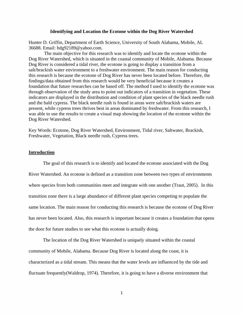
Figure 1: Example of ecotone with black needle rush and bald
cypress in same location.
displays both, a salt/brackish water environment and a freshwater environment. Therefore, the
type of ecotone associated with Dog River is one that displays the transition of vegetation from a
salt/brackish water environment to a freshwater environment. This type of ecotone is displayed if
figure 1, which show bald cypress and black needle rush present in the same location.
To locate this ecotone
there are two species of
vegetation I will use to study
the ecotone. These two
species of vegetation are the
bald cypress and the black
needle rush. The bald Cypress
is a great indicator of
freshwater vegetation because
these trees thrive in this environment. Also, the Cypress can live in areas with low salinity levels.
However, these trees found in areas of low salinity appear to struggle. The other type of
vegetation used for this research is the Black Needle Rush because it is a good indicator of a
salt/brackish water environment (Duncan, 1987). This plant is a good indicator of the ecotone
because it dominates salt/brackish water areas as well as areas on the edge of the ecotone where
salinity levels are low.
Research Question
Where is the location of the Dog River ecotone that identifies the transition zone from a
salt/brackish water environment to a freshwater environment?
3
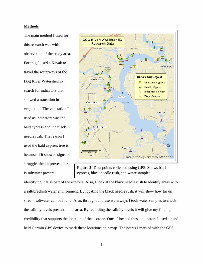
Figure 2: Data points collected using GPS. Shows bald cypress, black needle rush, and water samples.
Methods
The main method I used for
this research was with
observation of the study area.
For this, I used a Kayak to
travel the waterways of the
Dog River Watershed to
search for indicators that
showed a transition in
vegetation. The vegetation I
used as indicators was the
bald cypress and the black
needle rush. The reason I
used the bald cypress tree is
because if it showed signs of
struggle, then it proves there
is saltwater present,
identifying that as part of the ecotone. Also, I look at the black needle rush to identify areas with
a salt/brackish water environment. By locating the black needle rush, it will show how far up
stream saltwater can be found. Also, throughout these waterways I took water samples to check
the salinity levels present in the area. By recording the salinity levels it will give my finding
credibility that supports the location of the ecotone. Once I located these indicators I used a hand
held Garmin GPS device to mark these locations on a map. The points I marked with the GPS
4
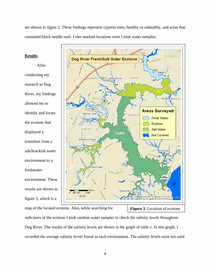
Figure 3: Location of ecotone
are shown in figure 2. These findings represent cypress trees, healthy or unhealthy, and areas that
contained black needle rush. I also marked locations were I took water samples.
Results
After
conducting my
research in Dog
River, my findings
allowed me to
identify and locate
the ecotone that
displayed a
transition from a
salt/brackish water
environment to a
freshwater
environment. These
results are shown in
figure 3, which is a
map of the located ecotone. Also, while searching for
indicators of the ecotone I took random water samples to check the salinity levels throughout
Dog River. The results of the salinity levels are shown in the graph of table 1. In this graph, I
recorded the average salinity levels found in each environment. The salinity levels were not used

5
Table 1: Salinity levels
to map the ecotone. However, I used these results to backup my findings of the ecotones’
location.
Discussion / Conclusions
After conducting my research I
was able to identify and locate the
ecotone in Dog River. These results
are important because they now lay a
foundation for future research dealing with this issue. For instance, if someone wanted to do
future resea rch associated with the Dog River ecotone, they now have a foundation to base their
research off. Therefore, through my findings I feel as if I have opened a new door for future
research.
Now that I have identified and located the ecotone in the Dog River Watershed, I think it
would be interesting and beneficial to do a research on the impact of saltwater intrusion. The
reason I would like to see this is because this was what I originally planned for my project to be.
However, I ran into the problem of not having anything to base my study off. This was because
the ecotone has never been located, until now. Therefore, in the future I would like to some kind
of research on saltwater intrusion to see if its’ had any serious impacts to the Dog River
Watershed. This is an important question to answer because the impacts caused by saltwater
intrusion don’t occur overnight, but take time for the real damage to be noticeable (Ranjan,
2007). However, once the damage has been done, it’s almost impossible to reverse it.
6
Work Cited Attrill, M. J., S. D. Rundle. (2002). Ecotone or Ecocline: Ecological Boundaries in Estuaries.
Estuarine, Coastal and Shelf Science (2002), 55, 929–936 Retrieved: 8 April 2013. From: http://ac.els-cdn.com/S027277140291036X/1-s2.0-S027277140291036X-main.pdf?_tid=8c5653da-a8f8-11e2-92f1-00000aab0f27&acdnat=1366379803_8d10c011fbcc23da32e120eab653cc6a
Duncan, H. Wilbur and Marion Duncan (1987).Seaside Plants of the Gulf and Atlantic Coasts.Washington D.C. Smithsonian Institution Press.
Mohr, Charles. (1969). Plant Life of Alabama.Vol. 2. New York: Verlag Von J. Cramer. Ranjan, Priyantha, 2007. Effect of Climate Change and Land Use Change on Saltwater
Intrusion.Retrieved 26 February 2013.from: http://www.eoearth.org/article/Effect_of_climate_change_and_land_use_change_on_saltwater_intrusion
Traut, H. Bibit (2005). “The Role of Coastal Ecotones: A Case study of the Salt Marsh/Upland Transition Zone in California.” Journal of Ecology vol. 93 no. 2.Retrieved: 10 March 2013. From: www.jstor.org/stable/3599395
Waldrop, W. R., R. C. Farmer, and P. A. Bryant (1974). Saltwater Intrusion into a Flowing Stream. Technical Report no. 161. Coastal Studies Institute. Retrieved 3 March 2013. From: http://ntrs.nasa.gov/archive/nasa/casi.ntrs.nasa.gov/19740020781_1974020781.pdf