Embed Size (px)
Citation preview
IDR visor map: a simple and friendly
geographical information system
J.D. Garcia-Consuegra, J.A. Gallud & F. Abad
IDR-S. Teledeteccion y GIS, Departamento de Informatica,
Universidad de Castilla-La Mancha, Spain
e-mail: {jgalludjdgarcia} @info-ab. uclm. es
Abstract
Nowadays, the construction of a Geographical Information System on acommercial package takes up a great deal of time and resources. However, thedistribution of such an application can be more expensive than the constructionbecause of the need to distribute the commercial package with the application.Usually, commercial packages cover this lack by providing reduced versionsfrom their powerful applications. With the IDR Visor Map we have developed alow-cost and at the same time powerful GIS which allows us to distribute GISapplications on a friendly workbench (Windows NT and 95). The IDR Visor Maphas been developed using an object oriented paradigm (OO). This paper showsour experience in the design and implementation of a new GIS called IDR VisorMap, as well as some of its capabilities. The addition of some classes to thepowerful Microsoft Foundation Classes (MFC) has developed this application.Such classes provide the layout to integrate and to monitor raster, polygon andvector images, a key aspect in the process of managing spatial information. Thisinformation is used together with the ODBC interface to obtain aditional datafrom a georeferenced database. The main advantages of the IDR Visor Map arescalability and flexibility, since our tool could be improved to offer the samecapabilities that can be found in commercial GIS. On the other hand, thedistribution of the IDR Visor Map tool has a minimal cost; furthermore, ad hocapplications can be easily implemented using our libraries. Our experience in thisarea says that a GIS, as the IDR Visor Map, must be able to answer all requestsand demands from users, what means that features like flexibility and scalabilitymust be taken into account in the construction of a GIS application.
Transactions on Information and Communications Technologies vol 18, © 1998 WIT Press, www.witpress.com, ISSN 1743-3517
294 GIS Technologies and their Environmental Applications
1 IDR Visor Map's Features and Capabilities
The origin of this project called IDR Visor Map was in the need toprovide sophisticated data for our real clients. The Regional DevelopingInstitute's Remote Sensing and GIS Section receives a great number ofrequests about partial studies of a geographical zone. Such studies shouldbe constructed to generate not only paper-based results but also togenerate them in a visual and manageable way. We needed to get aGeographical Information System (GIS) to solve such problems [6,7].
Why have we designed a GIS?. The main requirements of our clientsare simple, like monitoring, printing, and other operations related to
satellite imagery. We must offer not only a powerful and flexible tool butalso, most importantly, a low-cost GIS. Thus, a first aim of such a projectwas to develop a low-cost Geographical Information System, whichcovers the needs of our clients! 10,11,12].
Moreover, a number of libraries and workbenches have recentlyappeared, that might be thought good enough for our purpose [1]. This is,unfortunately, not the case: these tools do not provide the capabilities wewould want to endow the GIS with. Such capacity and flexibility aremore easily obtained by modelling the system using the object orientedparadigm.
Recently, there has been a noticeable increase in object-orientedapproaches [4]. The organisation of spatial data in computer systems hasreceived considerable attention in the field of GIS. In a simplified form,we are interested in knowing what is where and when, using an object-based concept of the "real world". There are several proposals of OO-GISlike GEO++ system [8] and some others that look like solving theimplementation problem [2]. Such prototypes have a disadvantage: theyare usually closed systems, so it is more difficult to adapt them to aparticular case.
We have designed and included our classes in the MicrosoftFoundation Class. Our purpose is to obtain a personal computer based-GIS; this criterion obliged us to undertake the study of this known classin order to incorporate several subclasses. This method has allowed us todesign a powerful, flexible and low-cost GIS. Thus, we can scale our GISas much as the standard libraries like MFC, OpenGL, ActiveX, OCX,DLL do.
Transactions on Information and Communications Technologies vol 18, © 1998 WIT Press, www.witpress.com, ISSN 1743-3517
GIS Technologies and their Environmental Applications 295
The IDR Visor Map GIS has a number of procedures grouped intothree categories: visualization functions, database functions and GUIfunctions. The user can manage segment data, vector map data, rasterimage and polygon images, which can be related to alphanumericinformation [3], as well as mix and filter these data. The IDR Visor Mapmanages such information by several layers, one for each data type. Wehave defined a set of classes to represent them. In this sense, the IDR
Visor Map is much more than a simple integration approach [5], since inVisor Map we have established the grounds of a complete GIS.
The rest of the paper is organized in three sections: in section two weexplain the class designed and its integration in the Microsoft FoundationClass; in section three we give an example of the IDR Visor Mappossibilities. Finally we discuss the conclusions and future work.
2 Inside of IDR Visor Map
The implementation of the IDR Visor Map is explained in two stages.First, we describe the set of functions that are offered by our GIS. Then,we will explain how these functions have been implemented by addingsome classes to the Microsoft Foundation Classes.
2.1 IDR Visor Map functionality
The functionality of GIS follows a known schema based on ten majorcategories [9]: capture, transfer, validate and edit, store and structure,restructure, generalize, transform, query, analysis and present. The IDRVisor Map offers a number of functions but not all of them, which will beimplemented in a future release. The functions offered by our applicationare the following: validate and edit attributes, all the capabilities includedin the store and structure category, query and information presentation.
The description given of the list of procedures and functions showsthe functionality of our GIS which a user can employ in order to managesome spatial information together with one or more georeferenceddatabases, which provide additional information in alphanumeric format.The following enumeration of the procedures and functions is included inthe validate & edit, data presentation, and store & structure categories:
Transactions on Information and Communications Technologies vol 18, © 1998 WIT Press, www.witpress.com, ISSN 1743-3517
296 GIS Technologies and their Environmental Applications
a) Functions to manage image and text files: A GIS must offer anumber of operations which allow us to manage different datafiles, which are raster, polygon, segment and text. A dynamiclink library has been developed in order to provide someprocedures to process remotely sensed imagery.
b) Image visualization operations as zoom operation, multiplewindows, etc.
c) Data operations: to add a layer, to eliminate a layer, to changedata properties, etc.
d) Edition functions: these allow us to modify a file, to get a bitmapfile with window information, etc.
e) Database capabilities: to acquire relevant information about theshowed image (pixel info).
f) Database management: this includes the procedures neceessary tomaintain the databases.
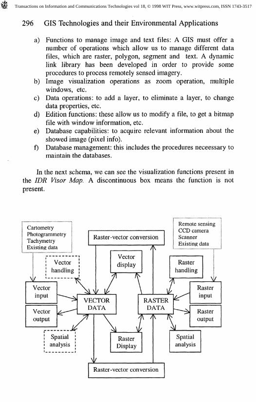
In the next schema, we can see the visualization functions present inthe IDR Visor Map. A discontinuous box means the function is not
present.
CartometryPhotogrammetryTachymetryExisting data
Raster-vector conversion
Remote sensingCCD cameraScannerExisting data
Raster-vector conversion
Transactions on Information and Communications Technologies vol 18, © 1998 WIT Press, www.witpress.com, ISSN 1743-3517
GIS Technologies and their Environmental Applications 297
Query and analysis are the main functions of GIS. So, in addition tothe above list of functions, we are going to describe our databasemanagement system which form the main level of the IDR Visor Map.We have defined three databases to store three different data types, asfollows:
a) Information about the database structure (a query generator usesthis kind of information), together with auxiliary tables to storeattribute values like colour, pen attributes, brush attributes and soon.
b) A database to manage data files with information about the mapsgenerated and its structure.
c) A module with the procedures to visualizate all kind of images.In this database we have the tables needed to store all alfanumericinformation related to each problem.
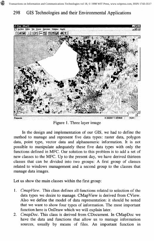
The IDR Visor Map offers a graphical user interface to access to allinformation types. Users open or create a MAP file when they init ourapplication. At this point, they can add, view, hide, and consult a layer.IDR Visor Map is able to manage five layer types: raster, segment,polygon, text and punctual, represented by icons. The number of layersopen in a MAP file is not bounded. Each layer can be related toalphanumeric data through the key field.
In the figure 1, we can see the IDR Visor Map showing a Landsat-TM satellite image in raster format from Castilla-La Mancha Region inSpain.
2.2 IDR Visor Map visualization module implementation
The most complex module of our application is the visualization code. Inthis section we are going to focus on describing the implementationdetails of visualization. The IDR Visor Map uses Microsoft FoundationClass to derive the required classes. MFC defines a root class namedCObject and each Windows application includes four basic classesderived from CObject. These four classes are CDocument, CFrameWnd,CView and CWinApp. Functions implemented in these four classes allowus to manage a generic Window program. Nowadays, this visualizationmodule has been become an OCX (OLE Control).
Transactions on Information and Communications Technologies vol 18, © 1998 WIT Press, www.witpress.com, ISSN 1743-3517
298 GIS Technologies and their Environmental Applications
Figure I. Three layer image
In the design and implementation of our GIS, we had to define themethod to manage and represent five data types: raster data, polygondata, point type, vector data and alphanumeric information. It is notpossible to manipulate adequately these five data types with only thefunctions defined in MFC. Our solution to this problem is to add a set ofnew classes to the MFC. Up to the present day, we have derived thirteenclasses that can be divided into two groups: A first group of classesrelated to windows management and a second group to the classes thatmanage data images.
Let us show the main classes within the first group:
1. CmapView. This class defines all functions related to selection of thedata types we desire to manage. CMapView is derived from CView.Also we define the model of data representation: it should be notedthat we want to show four types of information. The most importantfunction here is OnDraw which we will explain later.
2. CmapDoc. This class is derived from CDocument. In CMapDoc wehave the data and functions that allow us to manage informationsources, usually by means of files. An important function in
Transactions on Information and Communications Technologies vol 18, © 1998 WIT Press, www.witpress.com, ISSN 1743-3517
GIS Technologies and their Environmental Applications 299
CMapDoc is AddLayer: this function allows the user to add a newlayer onto an image.
3. CdialogOpen. CDialogOpen is a class derived from CFileDialog.This class manages the window dialogs related to file treatments.
4. CmapText. This class is derived from CObject and manages thealfanumeric information.
In the second group we can see the classes that provide the functions forproblem solving:
1. Vector type. We have two specific classes supporting the vector data:1. Clayer. CLayer is derived from CObject. This class takes charge
of supporting vector images in order to its representation andvisualization.
2. Csegment. This class is also derived from CObject and takescharge of showing the segments of any vector image.
2. Raster type. We have one only class for raster type: CLayerMPD.This class is derived from CObject and manages and represents theraster data type.
3. Polygon type. We have defined two classes associated to polygonimages:
1. Cpolygon. We have derived this class from CObject. This classmanages polygon data to provide image visualization andrepresentation.
2. CLayerPOL. CLayerPOL is a class derived from CLayer andtakes charge of managing each segment and polygon to composea polygon image. This is possible since CLayerPOL includes twoobjects of the MFC COblist class with all segments andpolygons.
4. Icon and Text types. Another two classes are defined to support iconand text information: Clayerlco and ClayerTxt.
We cannot explain all functions defined in each class, as it wouldtake too long. However we show to explain the behaviour of the systemby describing an example.
Transactions on Information and Communications Technologies vol 18, © 1998 WIT Press, www.witpress.com, ISSN 1743-3517
300 GIS Technologies and their Environmental Applications
3 The IDR Visor Map: An Example
The last section has showed how our tool is implemented. Now we aregoing to explain how the IDR Visor Map works from a user's point ofview. The user does not need to know anything about OOP (ObjectOriented Programming) of the GIS: it is a design criterion.
A GIS user usually searches for geographical data of a zone byexploring the features of different images. As we can see in the figure 2,where a Landsat TM image (in raster format) of the Albacete province isshown.
Some related information can be obtained from this image (pixelinfo). Thus, selecting a determined pixel we can obtain its geographicalcoordinates as well as its digital value. When we are working with aclassified image, information about the class to which it belongs(centroide, statistics, etc.) can be retrieved. The//}/? Visor Map allows usto get a new image by overlapping a vector data on the raster image. Forexample, if we want to see which rivers cross the region and where theyare, then we have to add a vector image (rivers).
Together with pixel info, this GIS offers the possibility ofassociating and consulting alphanumeric information of each data type bya previously made selection.
The IDR Visor Map also works in the opposite direction. The usercan observe how an attribute value is spatially distributed. Also, the result(spatial objects or attributes of the spatial objects) of a query can bedisplayed in the form of a table and a graphic, as well as being render onthe screen as a new layer or be highlighted.
It can be noted that in all this process we assume there are a set offiles containing all kinds of data: raster, text, vector and polygoninformation. This means that a the IDR Visor Map user has to scan theimages, introduce information and obtain the satellite data, so that GIScan work over the desired region.
This example has a number of limitations. It only shows a partialexecution of the IDR Visor Map to give a global point of view. The IDRVisor Map offers all GIS facilities and depends on the user's knowledgeabout GIS and Remote Sensing.
Transactions on Information and Communications Technologies vol 18, © 1998 WIT Press, www.witpress.com, ISSN 1743-3517
GIS Technologies and their Environmental Applications 301
4 Conclusions and Future Work
In this paper we have showed the implementation of a low-cost GIScalled the IDR Visor Map. The design of our application using a numberof standard libraries, allow us to add capabilities in a easier way. As anexample, the newer releases allow polygon to be filled in with bitmapfiles of 32x32 pixels or more in Windows 95 and NT, respectively,instead of 8x8 bitmap files of Windows 3.x.
The IDR Visor Map represents an example in the effort to extend theuse of Geographical Information Systems by using hardware platformsbased on PC's or workstations and by designing a low-cost and GUIapplication. Our GIS offers a variety of functions or procedures tomanage and at the same time process raster images, in order to consult ageographical area. The IDR Visor Map together with the DLL librarieshave been shown to be good enough to cover our clients' needs.
Object oriented programming has permitted an adequatestructurization of the geographical information that is to be analyzed. Inaddition, OO modelling has provided the new class generation from aninitial class by using the heredity feature. In particular we have defined anumber of new classes to manage special data, of these, CMapText,CSegment, CLayerMPD and CPolygon are the most important. The IDRVisor Map hides class hierarchy from the user, so that he can focus onobtaining information from a set of images.
At present, we are working on extending the IDR Visor Mapcapabilities such as manipulating segments as well as polygons, settingthe location of points, text, introducing "extended query", providing anintranet version based on ActiveX and introducing the 3D representationusing the OpenGL standard for Windows 95 and NT.
References
[1] Chen, P.P.S., "The Entity Relationship Model: Towards a UnifiedView of Data", ACM Transactions on Database Systems, 1, 1, 1976,pp.9-36.
Transactions on Information and Communications Technologies vol 18, © 1998 WIT Press, www.witpress.com, ISSN 1743-3517
302 GIS Technologies and their Environmental Applications
[2] Gahegan, M.N., Roberts, S.A., "An Intelligent, Object-OrientedGeographical Information System", IJGIS 2,2,1988, pp.101-110.
[3] Hughes, J.G., "Object-Oriented Databases", Prentice Hall, New York,1991.
[4] Kufoniyi, O., "An Introduction to Object-Oriented Data Structures",ITC Journal 1995-1, pp. 1-7.
[5] Kuo, Y.J., "Design Considerations for an Integrated GIS based on aPersistent Programing Language", ITC Journal 1995-1, pp.8-17.
[6] Lillesand, T.M., Kiefer, R.W., "Remote Sensing and ImageInterpretation" 2^ Edition, John Wiley & Sons.
[7] Mather, P.M., "Computer Processing of Remotely-Sensed Images",John Wiley & Sons.
[8] Vijlbrief, T., Oosterom, P., "The GEO++ System: an ExtensibleGIS", Proc 5th Int Symp on Spatial Data Handling 1995, pp.40-50.
[9] Maguire, D.J., Goodchild, M.F., Rhind, D.W., "GeographicalInformation Systems", Longman Scientic & Technical, 1991.
[10] Tomlin, C.D., "Geographic Information Systems and CartogrphicModeling", Prentice Hall, 1990.
[11] Bernhardsen, T., "Geographic Information Systems", VIAK ITand Norwegian Mapping Authority, 1992.
[12] Worrall, L., "Geographic Information Systems: Developmentsand Applications", Belhaven Press, 1990.
Transactions on Information and Communications Technologies vol 18, © 1998 WIT Press, www.witpress.com, ISSN 1743-3517