Embed Size (px)
Citation preview

I .- .
I METRIC JMIL-D-89029 (NAVY)27 JZUWJARY 1995
MILITARY SPECIFICATION
DIGITAL0.1
DIGITAL0.5
This specification is
BATHYMETRIC DATA BASEMINUTE (DBDB -0.1 )
andBATHYMETRIC DATA BASEMINUTE (DBDB-O .5)
approved for use by the Navai OceanographicOffice, Department of the Navy, and is avaiiabia for use by aii
Departments and Agencies of the Department of Defense.
1. SCOPE
1.1 m. Conformance to these specifications will ensureuniformity of treatment among all mapping and charting elementsengaged in a coordinated production and maintenance program forthis product. There is no systematic maintenance program for DBDBproducts. Maintenance of individual products may be done on as
. .needea Dasls.
1.2 BJJQQs=. The purpose of this document is to specify theformat, content, related product design and details necessary forthe production of DBDB-O.1 and DBDB-O.5.
1.3 This Specification is UNCLASSIFIED. DBDB-O.1and DBDB-O.5 are classified SECRET because of the detailed surveysincorporated into the source material. The delineation ofgeographic coverage for DBDB-O.1 and DBDB-O.5 is classifiedSECRET .
Beneficial comments (recommendations, additiona, deletions)and any pertinent data which may be of use in improvingthis document should be addreaaed to: Director, DefenseMapping Agency, A’TTN: PR (ST A-13), 8613 Lee Highway,Fairfax, VA 22031-2137 by using the StandardizationDocument Improvement Proposal (DD Form 1426) appearing atthe end of this document or by letter.
A14SC N/A MEA MCGT
~. This specification is approved ‘orpublic release; distribution is unlimited.

MIL-D-89029
2. APPLICABLE DOCUMENTS
2,1.1 ns. Thefollowing specifications, standards, and handbooks form a part ofthis document to the extent specified herein. Unless otherwisespecified, the issues of these documents are those listed in thecurrent department of defense Index of Specifications andStandards (DODISS) and the supplement thereto, cited in thesolicitation (see 6.2) .
Military Standards
MIL-STD-129 Marking for Shipping and Storage
MIL-STD-2414 DMA Bar Coding
MIL-STD-600001 MChG Accuracy Standard
(Unless otherwise indicated, copies of federal and militaryspecifications, standards, and handbooks are available from theStandardization Documents Order Desk, Bldg. 4D, 700 Robbins Avenue,Philadelphia, PA 19111-5094). ●
2.1.2 QLb_er GOV~ dra w~ ..
This section is not applicable to this specification.
2.2 Non-Gove~ubllcat~o~. . .This section is not
applicable to this specification.
2.3 ~. In the event of a conflict betweenthe text of this document and the references cited herein (exceptfor related associated detail specifications, specificationsheets, or standards) the text of this document takes precedence.Nothing in this document, however, supersedes applicable laws andregulations unless a specific exemption has been obtained.
3. REQUIREMENTS
3.1 ~. When specifiedbe subjected to first article inspectionwith 4.3.
(see 6.2), a sample shall(see 6.3) in accordance
3.2 ACCULQL. At the present, there is no formalrequirement for absolute or relative accuracy of DBDB-O.I andDBDB-O.5. The following are included as program objectives only.
3.2.1 RBDB-O.1 a~. The horizontalaccuracy in surveyed areas is < 91 meters (0.05 nautical miles) ●
2
L

@
MIL-D-89029
Circular Error (C.E.) 90% with respect to World Geodetic System(WGS) .
3.2.2 L?BRB-O.1 . The verticalaccuracy in areas surveyed by multibeam sonar is < 9 meters (5fathoms) Linear Error (L.E.) 90% with respect to Mean Sea Level(MSL), using a standardized sound velocity in sea water of 4800feet per second.
3.2.3 RMIB-O.5 absolute The horizontalaccuracy in surveyed areas is < 457 meters (0.25 nautical miles)Circular Error (C.E.) 90% with respect to World Geodetic System(WGS) .
3.2.4 RFLDB-O.5 a~ute vert~. The verticalaccuracy in surveyed areas is < 18 meters (10 fathoms) LinearError (L.E.) 90 percent with respect to Mean Sea Level (MSL),using a standardized sound velocity in sea water of 1500 metersper second.
Note : Reference MIL-STD-600001, for accuracy definitions.
3.3.1 Vertical Datum shall be”MSL.
3.3.2 ~ datum. Horizontal Datum shall be the WorldGeodetic System (WGS) DBDB-O.1 and DBDB-O.5 shall be compiled tothe current WGS datum or revised to be compatible with the currentWGS datum.
3.4 ~. This format is intended for thepurpose of production, storage and exchange of DBDB-O.1 and DBDE-0.5.
3.4.1 ~cs. . d~ .
,.,of DBDB
shall be written as byte addressable files (Table I) .
3.4.2 ~. The data format containsno system dependent data structures or system dependent generatedcontrol words.
3.5 ~.,.
The Data Base for DBDB-O.1 and DBDB-0.5 is divided into six distinct geographic areas (see Table I).There is both an index file and a data file associated with eacharea . At the present time not all geographic areas have beenpopulated. The depth information for DBDB-O.I is expressed infathoms, uncorrected at an assumed sound velocity of 4800 feet persecond. The depth information for DBDB-O.5 is expressed inmeters, uncorrected at an assumed sound velocity of 1500 metersper second. The depth posts are defined by the intersections ofrows and columns within a matrix. The matrix interval (or grid
I3

. .
post spacing), defined inminUteS for DBDB-O.1, and
MIL-D-89029
terms of geographic arc minutes is 0.10.5 minutes for DBDB-O.5. ●
Note: All values in minutes are in terms of arc measure.
TABLE I.
ZONE LATITUDE LONGITUDEI 00” N- 84” NII
100” W - 040- E00- N - 84” N
III040” E - 120” E
00- N - 84” NIV
120” E - 100” W80” S - 00” N
v070” W - 020- E
80” S - 00” N 020- E – 150- E
I 3.5.1 ~acte~.,,
Two file types areassociated with each of the six geographic areas. The first fileis an index file that contains information and byte addresses tothe actual data in the data file. The second, or data file,contains the gridded depth values and their associated attributes.The data are organized into one degree (latitude) by one degree(longitude) areas called cells.
3.5.2 File
3.5.2.1 The index file contains o
a 36 byte header indicating the geographic limits covered by thefile and its associated data file, grid spacing, cell size, numberof rows and columns of data, and endian indicator. Following theheader information, the remaining bytes contain the byte addressesto the actual data in the data file, along with the year andjulian day when this cell of data was created or updated. Theaddresses are ordered geographically first by latitude (startingat the southernmost latitude) and then by longitude (starting atthe western boundary of the file and moving east) . FIGURE 1applies. Each address is the byte address in the associated datafile that contains the gridded depth values for a cell. The indexfile is byte addressable, sequential data, containing no imbeddedformat information. An address value equal to minus one indicatesno data exists in the data file corresponding to that cell.
I
3.5.2.2 The data file is byteaddressable, sequential data, containing no imbedded formatinformation. Each depth value, for DBDB-O.1, is stored as anunsigned short integer (2 bytes), and as the integer part of thereal depth value times ten. Each depth value, for DBDB-O.5 isstored as a short integer (2 bytes) . The depth values are orderedgeographically, over the extent of the specific cell, first bylatitude and then by longitude (see FIGURE 2) . For grid nodesthat are void of data (i.e., have not been fully compiled) orrepresent land the depth value is replaced by distinct null ●
4
I

. .
MIL-D-89029
values . Land node values are
● integer value, and void nodes0.1 and 32,767 for DBDB-O.5.
NORTH
.
.
.
WEST
represented as zero or any negativeare represented as 65,535 for DBDB-
EAST
SOUTH
FIGuRE 1. a of in~.
NORTH
A
WEST + b EAST...
. . .(N:l)xxx...
“(1)(2) (3) v
SOUTH
FIGURE 2.
5
MIL-D-89029
3.5.2.3 to d~l~ r~~. The followingequation defines the position within the index file at which thedata file address is located for a given cell.
index_position = 36 (header size) + (4 (address size)+ 2 (year size) + 2 (julian_day size))* ((((int)lat - index_header .south_lat) *index_header width)+ ((int)lon - index_header .west_lon) )
or
index=position = 36 + 8((((int)lat - index_header .south_lat) ●index_header width)
+ ((int)lon - index_header .west_lon) )
3.5.3
3.5.3.1 le contents.
The header structure is:
Size in
IYK2e- Mscru2!x2n,.
west_lOn IEEE 4 represents in decimal degreesfloat the western boundary of the
index and associated data file.Hemisphere values arerepresented as O to 359.
east_lOn IEEE 4float
south_lat IEEE 4float
north lat IEEE 4—float
grid IEEE 4float
represents in decimal degreesthe eastern boundary of theindex and associated data file,Hemisphere values arerepresented as O to 359.
represents in decimal degreesthe southern boundary of theindex and associated data file.Southern hemisphere values arenegative .
represents in decimal degreesthe northern boundary of theindex and associated data fileSouthern hemisphere values arenegative
represents in decimal minutesthe grid spacing of the datavalues (always 0.5 for DBDB-O.5and 0.1 for DBDB-O.1) .
6
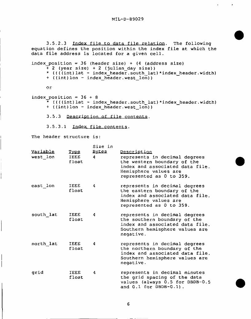
MIL-D-89029
Size in
●
I
IYEle w==cell integer 4
width integer 4
height
endian
integer 4
integer 4
The address structure contafollowing:
lYb2!2address integer
year shortinteger
julian_day shortinteger
Size
represents the cell size ininteger degrees in which thedata values are organized(always 1).
represents the width of theindex file in terms of cells(i.e. how many cells wide isindex file) .
represents the height of theindex file in terms of cells(i.e. how many cells high isindex file) .
indicates if the data waswritten little (least
the
the
significant bit first) or bigendian (most significant bitfirst) binary. This valuereturns ‘OXOOO1O2O3’ if you areaccessing the data on a machinethat has the same endian as itwas written on. Otherwise avalue of ‘OXO3O2O1OO’ iSreturned and byte swapping isrequired.
ns (width * height)
in
4 byte address inwhere the depthone degree cell
2 four digit year
number of the
the data filevalues for thisbegins.
2 julian day; indicates, whencombined with the year, whenthis one degree cell was createdor updated.
I

MIL-D-89029
3.5.3.2
a. DBDB-O.1
Size inm
depth unsigned 2 depth value (real value timesshort integer ten) .integer
type short 2 if type = 1, then depth integerinteger is based on survey data; if type
= O, depth is interpolated.
b. DBDB-O.5:
Size inPescr~~tlm
.
depth short 2 depth value in whole integersinteger
3.6.1 Each finished package will include themagnetic tape(s) , and an information booklet. The magnetictape(s) will contain, in addition to the data files, a C source ocode program for accessing the data files and a copy of this MIL-SPEC document, as ASCII character README.DOC files.
3.6.2 C&RQM. Each disc will be labeled indicating theseries, item, and edition of the CD-ROM, distribution/userinformation, national stock number, and producer (see FIGURE 3) .The CD-ROM will contain in addition to the data files, a C sourcecode program for accessing the data files and a copy of this MIL-SPEC document, as ASCII character README.DOC files.
3.6.3 U-ROM labeling.
3.6.3.1 Data C.lass,f~catlosl..
The highest classification ofany information contained on the disc shall be placed on thelabel . The classification shall appear at the top of the CD-ROMdisc.
3.6.3.2 .caxeas. The handling caveat markings shall appeardirectly below the data classification marking.
3.6.3.3 A 6.35 mm (.25 inch) thickcolor coded ring shall be placed along the outside perimeter ofthe disc label. CD-ROM discs will be color coded as follows toindicate the highest level of classification of the contents ofthe CD-ROM. ●

. .
MIL-D-89029
I
(a) Yellow Sensitive Compartmented Information
(b) Orange Top Secret
(c) Red Secret
(d) Blue Confidential
3.6.3.4Classification and declassification labels shall appear on the CD-ROM disc.
3.6.4 ~. The highest classification of anyinformation contained on the disc shall be placed on the cardboardsleeve. The cardboard sleeve includes the Location Diagram, whichis a graphic depiction of the geographic location of the contentson the CD-ROM. Package product title and artwork can either beprinted directly on the sleeve or on a gummed label which can beapplied to the sleeve. FIGURE 4. shows the format of thecardboard sleeve.
3.7 The information booklet willprovide general information about the contents of the tape(s) orCD-ROM(s), handling instructions, distribution/user information,and DMA point$ of contact.
4. QUALITY ASSURANCE
4.1 for ~. Unless otherwisespecified in the contract or purchase order, the contractor isresponsible for the performance of all inspection requirements(examinations and tests) as specified herein. Except as otherwisespecified in the contract or purchase order, the contractor mayuse own or any other facilities suitable for the performance ofthe inspection requirements specified herein, unless disapprovedby the Government. The Government reserves the right to performany of the inspections set forth in this specification where suchinspections are deemed necessary to ensure supplies and servicesconform to prescribed requirements.
4.1.1 All items shall meetall requirements of sections 3 and 5. The inspection set forth inthis specification shall become a part of the contractor’s overallinspection system or quality program. The absence of anyinspection requirements in the specification shall not relieve thecontractor of the responsibility of ensuring that all products orsupplies submitted to the Government for acceptance comply withall requirements of the contract. Sampling inspection, as partof manufacturing operations, is an acceptable practice toascertain conformance to requirements; however, this does notauthorize submission of known defective material, either indicatedor actual, nor does it commit the Government to accept defective
9

MIL-D-89029
material.
requ4.2 The inspectionrements specified herein are classified as follows:
a. First article inspection (See 4.3) .
b. Quality conformance inspection (see 4.4).
4.3 m art ~.!. When a first article
inspection is required (see 3.1 and 6.3) , it shall be examined fordefects specified in 4.4.1 and tested as specified in 4.4.2.
4.4 Quality conformanceinspection4.4.2.
I 4.4.1compliancewaiver has
I
shall include the examination on 4.4.1 and the test on
The database shall be examined forwith the requirements specified in section 3. Unless abeen cfranted non compliance with anv of the SDeCified
requirements shall constitute cause for rejection.
4.4.2 ~. A sample determined by the contracting officershall be read back after generation to ensure all files have beenproperly transferred.
4.5 The contractor shall notduplicate, copy, or otherwise reproduce the MChG property forpurposes other than those necessary for performance of the ●contract.
4.6 ~. At the ‘=wletion Ofperformance of the contract, the contractor, as directed by thecontracting officer, shall either destroy or return to theGovernment all government-furnished MC&G property not consumed inthe performance of the contract.
5. PACKAGING
5.1 ~. The DBDB files will be distributed on magnetictape (9-track tape, 8mm EXOBYTE or 4mm DAT) or CD-ROM.
5.2
5.2.1 tic tane. Each finished package will include themagnetic tape(s) , and an information booklet.
5.2.2 CkRQM. Each CD-ROM will be distributed in a cardboardsleeve containing an information booklet.
10

●
MIL-D-89029
Exceptasnoled,allb@ andtypeareblackonwhitebackground.Logosshownareexamples,useactualbgo inproduction.
S30rderamlClaasifiationin
As
7- ‘“” ‘“dasskationlevelofthe
/-7 ‘------ammo~at; ‘&lorfo;lhe
CLASSIFICATION prcd.mfmnfenfa,e.g.,-Blue:CONFIDENTIAL
HANDLING/DISTRIBUTION CAVEATS - Red:SECRET
-Ydb>: SCi
DEFENSE MAPPING AGENCY
k’ “ ‘YA
\ - Oranoe:ToriSecret
O/>&
. (_) j‘730 Dec19!+4
Claaaffladby:
,9(%8’” o
MuhlplsSources As applicable
DecleaaOn:OADR
ml Windows.UNIX
DMA VectorProduciLogoL ,,,.n,-,.-,m--..—-..,- m--- Basa (DB~B) DMA RasterProductLoge
operatingsystemas/ (u) UI$JISSIDuulyIlwlrlvu-m
;applicable applicable
IdentlflcatlonNumber
/ ‘\ Trademark,asapplicable
Classificationmatingsrequired,hem classificationmarkingwillbediffarentforproducfsthatare~lassifiadbyexistence
\
RequiredforTopSecretorcodeworddisks
FIGURE 3. ~.
11

. .
MIL-D-89029
I
I
I -1-T111I111#
1tI
:II1I1II
+
1II
CLASSIFICATIONLOCATION DIAGRAM
Geographic Area of Coverage:WON10WON
000”E to 000”E
Graphic depiction of the contents ofthe CD-ROM. Shaded area is actualcOverage.
DISTRIBUTION/USERINFORMATION
I IClassifiedby:Declassifyon: ~:
11I18I,II1II1
I1II11II1It1
FIGURE 4. ~.
5.3 Packaging shall be level C (see6.2) unless otherwise specified. This packaging provides minimumprotection, and it is needed to protect materiel under knownfavorable conditions. The following criteria determine therequirements for this degree of protection:
a. Use or consumption of the item at the first destination.
b. Shock , vibration, and static loading during the limitedtransportation cycle.
~c. Favorable warehouse environment for a maximum of 18 months. ●
12

MIL-D-89029
d. Effects of environmental exposure during shipment andintransit delays.
e. Stacking and supporting superimposed loads during shipmentand temporary storage.
5.4 In addition to any special markings required bythe contract or order, markings shall be in accordance withrequirements of MIL-STD-129 for military levels of protection.
5.5 Bar code markings are required andshall be applied in accordance to MIL-STD-2414.
6. NOTES
(This section contains information of a general orexplanatory nature that may be helpful, but is not mandatory.)
6.I ~. DBDB-O.1 and DBDB-O.5 are developed bythe Naval Oceanographic Office. The data bases are classified dueto the detailed nature of the surveys incorporated into the sourcematerial. The designed use of DBDB-O.1 and DBDB-O.5 is to supportthe generation of bathymetric chart products, and to providebathymetric data to be integrated with other geophysical andenvironmental parameters for ocean modeling.
6.1.1 ~BDB-O.l aen~. DBDB-O.1 is generated byinputting the digital source data or digitized contours through agridding routine developed by the Naval Oceanographic Office.This routine takes the values that fall within a grid node area ofinfluence and, utilizing a multi-stage minimum-curvature splinealgorithm, interpolates the values to derive a singlerepresentative depth value for each grid node.
6.1.2 Q.BJ2B-O.5ae~. DBDB-O.5 is generated in twodistinct manners:
a. It can be derived directly from the higher resolutionDBDB-O.1 by application of computer algorithms, or
b. When source data is primarily hard copy chartinformation, bathymetric contours are digitized at a rate of 21measurements per inch of contour and at a nominal chart scale of1:500000. These digitally-rendered contours are then put througha gridding routine developed by the Naval Oceanographic Office.This routine takes the values that fall within a grid node area ofinfluence and, utilizing a multi-stage minimum-curvature splinealgorithm, interpolates the values to derive a singlerepresentative depth value for each grid node.
6.2 ~. Acquisition documents mustspecify the following:
13

MIL-D-89029
Ia. Title, number, and date of this specification.
b. Issue of DODISS to be cited in the solicitation, and ifrequired, the specific issue of individual documents referenced(see 2.1.1 and 2.2).
1c. When a first article is required (see 3.1, 4.3, and
6.3).
d. Levels of packaging (see 5.3).
1 6.3 -t arti. When a first article is required, itshall be inspected and approved under appropriate provisions ofFAR 52.209. The first article shall be a preproduction sample.The contracting officer shall specify the appropriate type offirst article and the number of units to be furnished. Thecontracting officer shall also include specific instructions inacquisition documents regarding arrangements for selection,inspection, and approval of the first article.
6.4.1 ~. The degree of conformity with whichhorizontal position and vertical values are represented on a map,chart, or related product in relation to an established standard.
●a. Horizontal accuracy, absolute. The uncertainty in
horizontal position of a point with respect to the World GeodeticSystem caused by random and uncorrected systematic errors. Thevalue expressed as a circular error at the 90% confidence level.
b. Vertical accuracy, absolute. The uncertainty in theheight of a point with respect to Mean Sea Level caused by randomand systematic errors. The value expressed as a linear error atthe 90% confidence level.
6.4.2 C.Ql. One degree latitude by one degree longitudearea of coverage.
6.4.3 ~ erroc. An accuracy figure representing thestated percentage of probability that any point expressed as afunction of two linear components (for example, latitude andlongitude or northing and casting) will be within the givenfigure
6.4.4 ~. A geographicmatrix of depth values converted into a numerical format forcomputer storage and analysis at precise increments of latitudeand longitude,
6.4.5 A rectangular array of depth values.
14
.
●
I
aI
I
MIL-D-89029
6.4.6 ~. Describes the byte ordering used by differentcomputers. Little endian indicates the data was written withleast significant bit first (bit O is the rightmost bit). Big-.endian indicates the data was written with most significant bitfirst (bit O is the leftmost bit) .
6.4.7 ~. The difference between the true orknown value and the measured or derived value, and is normallyexpressed in terms of a percentage probability level. LE 90% iSthe term used to express the linear error at 90% probability, theMap Accuracy Standard. This refers to the vertical accuracy ofdepth data in the digital data base.
6.4.8the sea forelevations .
6.4.9value) .
~. The average height of the surface ofall stages of the tide, used as a reference for
6076 feet; 1852 meters (international
6.4.10 Geodetic Svstem (WGS) . A consistent set ofparameters describing the size and shape of the Earth, thepositions of a network with respect to the center of mass of theEarth, transformations from major geodetic datums, and thepotential of the earth (usually in terms of harmoniccoefficients) .
6.5 This sectionis not applicable to this specification.
36 byte headerbathymetric datadatabasegriddingmagnetic tape
15
. .
MIL-D-89029
INDEX
II
I
Accuracy ..........................................3.26.4.1
Acquisition requirements .....................,.. .’.6.2Applicable documents ..............................2.Cell ..............................................6.4.2Circular error ............................,.......6.4.3Classification of inspection ...................... 4.2Data file characteristics .........................3.s.2.2Data file contents. ...................,,..,..,....3,5.3.2Datum .............................................3.3DBDB-O.1 absolute horizontal accuracy ............. 3,2.1DBDB-O.1 absolute vertical accuracy ............... 3.2.2DBDB-O.l generation. ..............................6.1.1DBDB-O.5 absolute horizontal accuracy ............. 3.2.3DBDB-O.5 absolute vertical accuracy ............... 3.2.4DBDB-0.5 generation. ..............................6.1.2Definitions .......................................6.4Depth matrix ......................................6.4.5Description of file contents ...........,..........3.s.3Digital Bathymetric Data Base (DBDB) .............. 6.4.4Indian ............................................6.4.6Examination ...........................,, ,,.,......4.4.1File characteristics ..............................3.s .2File description.. ................................3.5First article .....................................3.1
6.3First article inspection ..........................4.3Government documents ..............................2.1Government furnished material ..................... 4.5Government property surplus .......................4.6Horizontal datum.. ................................3.3.2Index file characteristics ........................ 3.5.2.1Index file contents ...............................3.5.3.1Index file to data file relation .................. 3.5.2.3Intended use...... ................................6.1International Standardization Agreements ......... 6.5Linear error... ...................................6.4.7Logical characteristics ......................,....3.5.1Mean sea level ....................................6.4.8Nautical mile .....................................6.4.9Non-Government publications ....................... 2.2Notes .............................................6.Order of precedence. ..............................2.3Other Government documents, drawings,
and publications. ...............................2.1.2Physical characteristics of distribution media .. . 3.4.1Purpose ...........................................1.2Quality assurance .................................4.Quality conformance inspection .................... 4.4
PAGE2
14132
14141048323
1333
1314146
141510432 ●
14102
1010
34b6
1315154
15152
132
2319
10 ●16

I
MIL-D-89029
INDEX
Requirements ......................................3.Responsibility for compliance ..................... 4.1.1Responsibility for inspection ..................... 4.1Scope .............................................1.
1.1Security ..........................................1.3Specifications, standards, and handbooks .......... 2.1.1Standard format ...................................3.4Tests .............................................4.4.2TypeofInput/Output (1/0) ........................3.4.2Vertical sounding datum ...........................3.3.1World Geodetic System (WGS) .......................6.4.10
PAGE29911123
1033
15
17

Custodian
MIL-D-89029
CONCLUDING
: DMA - MPNAVY - NO
Review Activity: Navy - MC
MATERIAL
Preparing Activity:DMA - UP
18

●
STANDARDIZATION DOCUMENT IMPROVEMENT PROPOSAL
1. Thepreparing acfivity nustmmplete bb*al,2,3, and8. In bbdtl, beththe dmmmtnumbarandrevisbnletter shoutdbe given.
2. Thaaubrnkferoflhialonnm uaScwnpletebJceka4,5,6, and7.
3. The preparing acfJviiyMUSSprovfcfea reply wfmln 30daysfremrscelp4ofIfseform.
NOTE. TNs form may not be used 10 request mpies of documents, nor to requesf waivers, or clarifkation ofraquimmams on cament Wdracfs. COMTWItS submitted on this fOFM do not conaltiufe or impJy authorfzafiin towake any potion of the referenced document(a) or to amend mntracfual re~ireMerIfS,
I RECOMMEND A CHANGE: 1.GQXJMENT NUMSERMIL-P-a9029(NAvn I 2“ ‘WYW?m “’’’-o’
‘uMEWnTE Military Specification for DBDB-O.1 and OBDB-O.5
NATURE OF CHANGE (Idmtitigunw+h nutir mdtiuda PMPMnd d, ifpsibls. Am+! own dmm m ne9Ssd)
REASON FOR RECOMMENDAnON
SU6MITTERNAME [Lax FFSC~a hfWJ b, ORGANIZATION
AODRESS (~ ZV Cab) d. TELEPWNE (fncA#a Ar8s Cc+ 7. OA7E sUBMITIED
(l)c-am- (WUMOD)
(2) AUTOW3N@q@esM9J
PREPARING ACTIVllY
NAMEDefense Mapping Agency
b. TELEPHONE (/no’L& Arm Ccdsj[1) COmwcial (2) AUTOVON
AlTN: PR, ST A-13 (703) 265-9333 356-9333
ADORESS (Imhde ZkI Cede) IF YOU 00 NOT RECEIVE A REPLY WITNIN 45 OAVS, CONTACT:
6613LeeHiihwayFairfax. VA 22031-2137
%%&%?&%d %%%?%,%%, VA, 22041 -24S4Telephone 17 ) ?%-224o AUTOVON 2SS2S40
.,. . . ... . . . . . . . . .. . . !RxDD Form 1426, OCT 89 l-rwwuse-consamW.uvum. .—.