Embed Size (px)
Citation preview

IGWCO PRESENTATION
Rick LawfordSan FranciscoDecember 10, 2008

1. Provide a framework for guiding decisions on
priorities and strategies regarding water cycle
observations for: - Monitoring climate variability and
change, - Effective water management and sustainable development of the
world’s water resources, - Societal applications for resource development and environmental management, - Specification of initial conditions for weather and climate forecasts, - Research directed at priority water
cycle questions
2. Promote strategies that facilitate the processing, archiving and distribution of water cycle data products
THE INTEGRATED GLOBAL WATER CYCLETHE INTEGRATED GLOBAL WATER CYCLEOBSERVING THEME (IGWCO) HAS THEOBSERVING THEME (IGWCO) HAS THEFOLLOWING OBJECTIVES:FOLLOWING OBJECTIVES:
“HELP
ING
TO
SO
LVE T
HE W
ORLD
’S
WATER P
RO
BLE
MS W
ITH
IN
TEG
RATED
WATER C
YCLE
OBSERVATIO
NS
AN
D IN
FO
RM
ATIO
N”

GOALS LEADERS ACTIONS COMMITCOMMIT FUNDINGFUNDING
CEOP CEOP YESYES Merger Merger with GHPwith GHP
YESYES YES/JPYES/JP
PCPN YESYES Phil Arkin Workshops Workshops heldheld
YESYES NO
SOIL
MOIST.YESYES Tom Jackson
Peter v. Ovel
BeijingBeijing
Workshop Workshop plannedplanned
YESYES NO
RUNOFF YESYES Wolfang Grabs
HARON YESYES NO
WATER
QUALITYYESYES Steve Greb Workshop in Workshop in
GenevaGenevaYESYES GEOGEO
GWSP
LINKSPRELIMPRELIM Charles
VorosmartyTBD NO NO
GRND
WATERTBDTBD TBD TBD NO NO
CAP
BLDGYESYES AM, CI,RLAM, CI,RL EA workshop
SA proposalYESYES SOMESOME
Toshio KoikeJohn Roads

"Big picture" comparisons"Big picture" comparisonsVery high quality field program Very high quality field program
data sets data sets
High time resolution comparisonsHigh time resolution comparisons over selected limited regionsover selected limited regions
Continental/Regional ComparisonsContinental/Regional Comparisons
• Focus on three-hourly totals over 0.25°x0.25° areas, or finer resolution over wide variety of climatological and physical regimes
AS THE FIRST STEP IN THE DEVELOPMENT OF AN INTEGRATEDPRECIPITATION PRODUCT AN INTERCOMPARISON OF DIFFERENT HIGH RESOLUTION PRECIPITATION PRODUCTS IS BEING UNDERTAKEN.

Illin
ois
Point Local Regional GlobalExtent
Low
HighD
ensi
ty
Hourly
Monthly
Freq
uenc
y
Okl
ahom
a an
d
Mon
golia
REH
MED
US
SCA
N
Chi
na a
ndR
ussi
a
CE
OP
Selected Soil Moisture Networks
USD
A
Wat
ersh
eds
(4) ??
??
Real Time
Archival
THROUGH ITS SOIL MOISTURE EFFORTS IGWCOIS DEVELOPING A SET OF FOCUS ISSUESTHAT ALIGNS WITH THE GLOBAL CLIMATEOBSERVING SYSTEM (GCOS) IMPLEMENTATION PLAN
ISSUES TO BE CONSIDEREDFOR A GLOBAL NETWORK:- Extent of network- Density- Frequency of measurement- Latency- Availability- Measurement Technique
NOW
THE GOAL

User Groups with Water Quality Concerns Municipal drinking and sanitation utilitiesAgricultureRecreationIndustryEcological needs biological integrity
Anthropogenic StressorsLow and high flow volumes (minimum flow requirements)EutrophicationThermal DischargesDiffuse pollution (Urban and Rural)Mining discharge (Hard rock gold mining/cyanide)Pathogens
SATELLITE SYSTEM
CAPABILITIES(OPTICAL
WAVELENGTHS)
TROPHIC STATUS IMAGESFOR WATER BODIES NEAR EAGAN, MN FROM IKONOS DATA (FROM S. GREB)
SITESPECIFICMONITORING
GEO WORKSHOP HELDIN MARCH 2007 TO DEVELOP A STRATEGY FOR SATELLITEAPPLICATIONS TOWATER QUALITY.
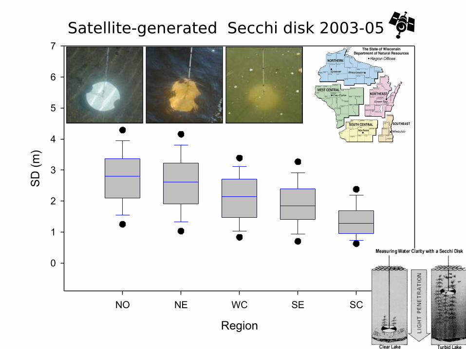
Region
NO NE WC SE SC
SD
(m
)
0
1
2
3
4
5
6
7
Satellite-generated Secchi disk 2003-05

Key workshop recommendations focused on:
•Continuity of existing satellites
•Development of new and improved sensor/platform technology •Algorithm development and calibration/validation activities •Improvements in data accessibility
•Increased education, and capacity building through new demonstration project initiatives
•Formation of a scientific group dedicated to inland and coastal water quality remote sensing
Another workshop is being planned for the USA to assess algorithms for estimatingwater quality from space.
GEO Inland and Nearshore Coastal Water Quality Remote Sensing Workshop

Global monitoring of runoff and lake storage:
- important elements of Integrated Global Observing Systems
- integral parts of water resources management including prevention of water-induced disasters
Hydrological Applications – Runoff Project (HARON)
Basic Rationale of the Initiative

Methodology: 251 calculated basins of Methodology: 251 calculated basins of stations close to the mouth using 0.5 deg stations close to the mouth using 0.5 deg DEMDEM
HARON – IGWCO Runoff Project
In line with IGWCO, GCOS and GEWEX main objectives: Improve and support the closure of the global water budget. Support water resources management (in context of food security).Initial phase: Upgrade and sustained maintenance of major global run-off stations. monitoring continental freshwater fluxes into the world’s oceans.2nd Phase: Combine hydro-meteorological and related in-situ components with satellite observations.3rd Phase: Produce implementation plan for broad global water cycle data integration system combining in-situ, satellite data and model outputs.

PHASE I – Upgrade & sustained maintenance of major global run-off stations, monitoring continental freshwater fluxes into the world’s oceans
PHASE II – Integration of hydro-meteorological and related in-situ components with satellite observations
PHASE III – Consolidation of integrated hydrological observation network development and application of user-oriented information products made available by HARON
Production of an implementation plan for a broad global water cycle data integration system, combining water cycle in-situ, satellite, and model output data
Implementation Phases
HYDROLOGICAL APPLICATIONS RUNOFF NETWORK PROJECT (HARON)

Results of a joint IGWCO/UNESCO/ Geohazards workshop:
More convergence is needed in national in-situ groundwater monitoring programmes to meet
GEOSS objectives
India QN QU W S mostly O mostly M 80% 4 1 DWS S yes N CH CChina QN QU W S S O O M S mostly 52 2 MI yes CH VIran QN QU W S Q S O O mostly M 12 2 MI no N CH C VSouth Africa QN QU W S S O O mostly M S 4 - 12 - 52 2 MI S no N CH C VAustralia QN QU W S S O O M S 4 1 mostly MI S yes N CH CBrazil - Sao Paulo QU W O O - - 1 DWS S no CH CRussia QN QU W S S O O mostly S mostly 12 - 36 4 - 12 DWS S yes N CH C VUSA QN QU W S S O O M S M variable 1 or more DWS S yes N CH C VPoland QN QU W S S O O M mainly 1 - 12 - 52 1- 2 or less DWS S yes CH CCzech Republic QN QU W S S O S 80% 52 2 DWS S yes CH CEngland, Wales QN QU W S S O O 80% M 80% 12 variable DWS S partially CH C V
Data collection C Central V Various
O One aquifer-well M More aquifers - well
GW table measurements M Manual S Sensor
Water table frequency measurementsper year
GW sampling per year
Country GW analysis DWS-Drink.Wat.Stan.MI Major Ions S Spec. Variables
GIS Data accessibilityCHCharge N-CH No charge
GW monitor. QN Quantity QU Quality
W Wells S Springs Q Qanats
S Special wells O Other wells
While standards are maintained for a number of water cycle variables by WMO there are a number of gaps for groundwater and water quality.
(After Vrba)

ALTERNATIVES FOR MEASURING GROUND WATER
MICROGRAVITYMEASUREMENTS
GW CHANGE (1989-1999)(after Dehnney)
Ground water monitoring
GRACEMeasurements

Coordinated Enhanced Observing Period
Interoperability Arrangement A well organized collecting, processing,
storing, and disseminating shared data, metadata and products
Data Integrating/Archiving Center at University of Tokyo and JAXA of
Japan
Model Output Data Archiving Center at the World Data Center for Climate, Max-Planck
Institute for Meteorology of Germany
In-Situ Data Archiving Center at NCAR
(National Center for Atmospheric Research)
of USA
Three Unique Capabilities

Océano AtlánticoOcéano Atlántico
OcéanoOcéanoPacíficoPacífico
A MODEL FOR A LATIN AMERICACAPACITY BUILDING INITIATIVE
Mission“Develop sustainable earth observation information
services for integrated water resources management in developing countries, with a focus on South America”
Key requirementsSustainability strategic partners neededAppropriateness level of technology must fit user’s capabilitiesUser engagement driven by South American users
Main SponsorCONAE, others possible

The Asian Water Cycle Approach to Integrated River Basin Management:
[integration of earth observation data] + [capacity development] programme
Basin 1 Basin 2 Basin 3 Basin 4
In-situ observation River management
use of satellite data
Modeling andanalysis
Common items
* Space Agencies
*ICHARM , MRC, etc.
In-situ data In-situ data In-situ data In-situ data
* UNU, universities & colleges etc.
Area data / information
Satellite data, global network data, numerical forecasting model, assimilation of data
Integration and use of earth observation data
Capacity Building

E2E INITIATIVES
The End-to-End Water (E2E-Water) will demonstrate the value of integratedwater cycle observations by developing a full and operational data cycle ofenvironmental information from "producer-to-consumer" / "source-to-sink“. Initial pilots: Impacts from drought; assessment of the global water resource base under the "State of the Global Water System" and “Water Towers of the World.” There will be six supporting objectives: 1) Develop pilot projects that will advance the use of integrated data products within the framework of IGWCO, GEO, and the GEO Water Cycle Community of Practice. 2) Engage core elements of the GTN-H data consortium and principal data provision affiliates;

3) Assemble theme-based application communities, composed of both data users and providers, to articulate the needs of data consumers directly to the data providers and to optimize the relevance and utility of integrated water cycle observations; 4) Develop integrated water cycle data sets, data assimilation schemes, geospatial models, and other necessary tools to serve the needs of the theme-based user community; 5) Translate E2E-Water outputs into concrete values that support GEO policy, development, management, and educational priorities. 6) Demonstrate the added value of IGWCO and GEO integrating water cycle information for various applications.
The E2E activity provides a testbed for IGWCO/GWSP indicators that arecurrently under development.

Water Cycle Tasks in the GEO 2009 – 2011 Work Plan
WA-06-02: Droughts, Floods and Water Resource ManagementAddress decision-making challenges related to the management of hydrometeorologicalextremes and the sustainable use of water.•Forecasting and Early Warning Systems for Droughts and Floods (Lead: USA)
Improve forecasting methods for extreme events (floods, droughts) usedby hydrological services throughout the world – to help bridge the gapbetween research and user communities. Includes Global Drought Early Warning System (GDEWS), European Flood
Alert System (EFAS), GMES/Kopernikus project GEOLAND and HEPEX.b) Impacts from Drought (Lead: Canada, WCCP)Track and analyze impacts from drought (including feedbacks such as soil drying) to provide a tangible and practical demonstration of the value of integrated watercycle observations. c) Mountain Water Resources (Lead:EC)Analyze the future of water resources in vulnerable mountain regions in the contextof climate change and increasing extreme events. It will include the Europeanproject ACQWA (Assessing Climatic change and impacts on the Quantity and qualityof WAter).

Water Cycle Tasks in the GEO 2009 – 2011 Work PlanWA-08-01: Integrated Products for Water Resource Management and ResearchImprovements and expansion of in-situ networks, combined with newsatellite missions (in addition to existing space-borne Earth observingsystems) and emerging assimilation and prediction capabilities, areopening the door to a new era in global water-cycle management.•Soil Moisture (Lead: ESA and WCRP)Establish a global soil moisture network suitable for the development of
multi-purpose soil moisture products. Apply in-situ based products to thecalibration and validation of remotely-sensed observations.
Runoff (Lead: Japan (University of Tokyo) and Switzerland (University of Geneva))Integrate, in a phased approach, dedicated river gauging networks of existinghydrological stations into a global runoff observation network. The main output of theHARON project (Hydrological Applications and Run-Off Network) will be strengthenedin-situ and satellite monitoring networks of estuaries, rivers, lakes, reservoirs, andgroundwater levels.
Groundwater (Lead: Netherlands (IGRAC))Establish a Global Groundwater Monitoring Network (GGMN) for a periodicassessment of global groundwater resources, using information from existing national,regional and global networks – in order to represent changes in groundwater resourcesat scales relevant to regional and global resource assessment.

Water Cycle Tasks in the GEO 2009 – 2011 Work PlanWA-08-01 (Cont’d): Integrated Products for Water Resource Management and Research
Precipitation (Lead: CGMS)Promote and advance the development and validation of multi-sensor satellite-basedprecipitation estimates, including snowfall. Inputs from the Precipitation VirtualConstellation (AR-09-02a) will supplement these efforts.
Water Cycle Data Integration (EC (CEOP-AEGIS) and WCRP (GEWEX))Upcoming satellite launches and plans for new missions provide new global data setsthat will supplement the in-situ networks for many water cycle variables. TheCoordinated Energy and water cycle Observations Project (CEOP) under the WCRPGlobal Energy and Water-cycle Experiment (GEWEX) is tailoring and developing toolsto access the various data collections and undertake data integration work over theInternet.
Pilot Projects for Improved Water Discovery and Quality Assessments (IEEE)Conduct pilot projects in cooperation with local and national governments and otherorganizations to provide water where it is needed, but not now available. Theseprojects will be focused on developing countries and realizable in the field withinone year. They will be sustainable, resusable, repeatable, and scalable.

A POSSIBLE WATER CYCLE WC COMMUNITY OFPRACTICE FOR COORDINATING GEO WATER ACTVITIES