Embed Size (px)
Citation preview
0
MISSISSIPPI RIVER AND
TRIBUTARIES WATERWAYS ACTION
PLAN
ILLINOIS WATERWAY ANNEX 2017
ILLINOIS WATERWAY ANNEX Introduction This appendix provides general information and target gauges to be used as a guideline for a crisis on the Illinois Waterway (ILWW). Like a crisis on the Upper Mississippi River (UMR), it is the responsibility of the United States Coast Guard, Army Corps of Engineers, and River Industry representatives to meet and discuss conditions on the ILWW and to annually review the actions specified in the plan. In Section 4 of this annex, the entire ILWW is broken into fourteen zones. Each zone is delineated by river mile and is characterized by river stage, with three action phases (e.g., Watch, Action, and Recovery Phases) described in the plan. A combination of reference gauges, historical data & known impact areas were used to derive these zones. Section 1 – Geographic Description The ILWW follows the channel of the Chicago Sanitary & Ship Canal from Chicago, then extends down the Des Plaines River and finally the Illinois River to its mouth at the Mississippi River near Grafton, Illinois. It also links to the calumet region via the Calumet Sag Channel. The waterway drops from 579.5’ above sea level at Lake Michigan to 419’ above sea level at Grafton, Illinois. To accommodate this drop, eight locks and dam sites were constructed along the waterway at Chicago, Lockport, Brandon Road, Dresden Island, Marseilles, Starved Rock, Peoria, and La Grange.
HYDROLOGY AND IMPACT CONCERNS
Flooding on the Illinois Waterway is normally caused by high flows on the ILWW, by backwater from the Upper Mississippi River (UMR) or a combination of both. The ILWW is said to "flood from the bottom up on most occasions.” Potential for damage is usually associated with extreme or prolonged high water conditions which reduce levee freeboard, saturate levees and increase seepage, while restricting access for repair. Along the middle section of the ILWW, damage to homes is of concern when the impact of high water is multiplied by the surge and suction caused by large commercial tows passing within close proximity of flooded homes. All of these issues must be taken into consideration when deciding to implement operating restrictions or cease traffic. Additionally, not all areas of concern are consistent throughout the entire length of the ILWW. In the upper reaches, safe navigating conditions for tows and locks operating restrictions are the predominant considerations. In the mid-reaches, the concerns are safe navigation and wake damage while, in the lower reaches, concern for levee conditions is paramount.
LOW WATER & ICE CONDITIONS
Waterway management concerns also occur during low water and ice conditions on the ILWW. Low water is of particular concern on the ILWW below Starved Rock Lock & Dam. This section of river is pooled by two wicket dams designed to hold the river to pool level or slightly above. These dams do not have the capability of holding more water in the pools. These pools are susceptible to rapid water level changes when a dam is placed into operation or is dropped to allow for open passage. Groundings during low water conditions delay commercial traffic, cause substantial damage to the navigation channel and can necessitate dredging. Ice condition not only reduces water levels but causes ice to build up underneath barges causing them to "ground"
2
without ever touching the river bottom. Ice navigation can be very difficult as the ice removes navigation buoys, causes ice gorges and damages the hulls of towing vessels and barges.
CONTROLLING FACTORS & WATERWAYS MANAGEMENT PLANNING
Under flood conditions, controlling factors are gauge readings at specific locales and locks. These are general elevations at which water levels may cause impact upon levee conditions, damage homes or create unsafe navigation conditions, as described in the “narrative” section of each zone. Well before water levels near or reach these levels, the Coast Guard in conjunction with Army Corps of Engineers (USACE), and industry shall implement the “Watch Phase” of the plan (which vary for each zone) e.g., establish communications to discuss the current and forecasted conditions. These discussions should include an analysis of data, weather history & forecast, impact upon river environment and commercial traffic requirements. Furthermore, general considerations such as levee conditions, wake damage, bridge clearances and lock operating restrictions/closures shall be discussed. If the conditions and time permit the USACE, USCG, and IRCA may observe test tows transiting an area, in order to determine if a river closure is warranted.
Section 2 – Parties and Roles U.S. Coast Guard The U. S. Coast Guard Sector Commander Upper Mississippi River, with its principal office in St Louis, MO and a smaller Marine Safety Detachment office in Peoria, IL, is responsible for safety of navigation, security, and law enforcement along the Illinois Waterway as far as mile marker 187; from that point, the responsibility belongs to the Coast Guard Sector Commander of Sector Lake Michigan working through the Coast Guard Marine Safety Unit Chicago. U.S. Army Corps of Engineers (USACE) The USACE maintains eight Lock and Dam facilities along the Illinois Waterway, under the Supervision of their Rock Island District Office on Arsenal Island in Rock Island, IL, St. Louis District Office in Downtown St. Louis and a Project Office in Peoria, IL. To the extent possible, through management of these facilities, the USACE maintains pool levels that are sufficient to accommodate commercial traffic on the river. U.S. Coast Guard District Eight Bridge Branch (dwb) The Bridge Administration Program has a mandated responsibility to protect the public’s right of navigation. Activities include determining location of navigation channel piers and issuing bridge permits. They establish, revise and monitor drawbridge regulations and prescribe bridge lighting. Also, Truman-Hobbs studies of unreasonable obstructive bridges are conducted on a nationwide basis. River Industry Action Committee (RIAC) RIAC is an association of companies and organizations who are stakeholders in the commercial industry on the inland rivers. As the name suggests, they act in an advisory capacity on a wide range of issues affecting the activities of the industry on the rivers. They provide an industry perspective to the Coast Guard and the USACE on matters such as high and low water, ice conditions, shoaling, marine accidents, etc.
3
Illinois River Carrier’s Association (IRCA) IRCA plays a similar role to that of RIAC, but keyed to only the ILWW, whereas RIAC may overlap the major inland rivers. Fleeting Facility Managers Fleeting facility managers have a direct commercial interest in navigation conditions on the ILWW, and any actions taken by the Coast Guard or USACE in response to hazardous conditions that develop on the river. They can play a valuable role in providing feedback to other parties on both river conditions and impact of proposed actions of the Coast Guard and USACE. Designated Waterfront Facilities Like the fleeting facility managers, the commercial interests of the designated waterfront facilities are directly impacted by navigation conditions on the ILWW, and any actions taken by the Coast Guard or USACE in response to hazardous conditions that develop on the river. They can play a valuable role in providing feedback to other parties on both river conditions and impact of proposed actions of the Coast Guard and USACE. State Emergency Managers Hazardous conditions on the ILWW, particularly high water/flooding conditions, frequently involve state emergency managers, as they become involved in responding to affected communities, and take a direct interest in conditions or activities that can affect the levee systems that protect those communities. Metropolitan Water Reclamation District (MWRD) The mission of the MWRD is to protect the health and safety of the public in its service area. Water flow within the District’s waterway system and the Lake Michigan discretionary diversion flow are controlled by three inlet structures on Lake Michigan: Wilmette Pumping Station, Chicago River Controlling Works and T.J. O’Brien Lock and Dam. The single outlet control structure is the Lockport Lock and Powerhouse.
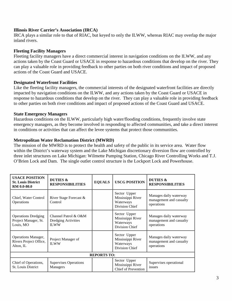
USACE POSITION St. Louis District RM 0.0-80.0
DUTIES & RESPONSIBILITIES EQUALS USCG POSITION DUTIES &
RESPONSIBILITIES
Chief, Water Control Operations
River Stage Forecast & Control
Sector Upper Mississippi River Waterways Division Chief
Manages daily waterway management and casualty operations
Operations Dredging Project Manager, St. Louis, MO
Channel Patrol & O&M Dredging Activities ILWW
Sector Upper Mississippi River Waterways Division Chief
Manages daily waterway management and casualty operations
Operations Manager, Rivers Project Office, Alton, IL
Project Manager of ILWW
Sector Upper Mississippi River Waterways Division Chief
Manages daily waterway management and casualty operations
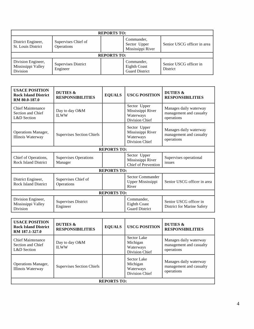
REPORTS TO:
Chief of Operations, St. Louis District
Supervises Operations Managers
Sector Upper Mississippi River Chief of Prevention
Supervises operational issues
4
USACE POSITION Rock Island District RM 80.0-187.0
DUTIES & RESPONSIBILITIES EQUALS USCG POSITION DUTIES &
RESPONSIBILITIES
Chief Maintenance Section and Chief L&D Section
Day to day O&M ILWW
Sector Upper Mississippi River Waterways Division Chief
Manages daily waterway management and casualty operations
Operations Manager, Illinois Waterway Supervises Section Chiefs
Sector Upper Mississippi River Waterways Division Chief
Manages daily waterway management and casualty operations
REPORTS TO:
Chief of Operations, Rock Island District
Supervises Operations Manager
Sector Upper Mississippi River Chief of Prevention
Supervises operational issues
REPORTS TO:
District Engineer, Rock Island District
Supervises Chief of Operations
Sector Commander Upper Mississippi River
Senior USCG officer in area
REPORTS TO: Division Engineer, Mississippi Valley Division
Supervises District Engineer
Commander, Eighth Coast Guard District
Senior USCG officer in District for Marine Safety
USACE POSITION Rock Island District RM 187.1-327.0
DUTIES & RESPONSIBILITIES EQUALS USCG POSITION DUTIES &
RESPONSIBILITIES
Chief Maintenance Section and Chief L&D Section
Day to day O&M ILWW
Sector Lake Michigan Waterways Division Chief
Manages daily waterway management and casualty operations
Operations Manager, Illinois Waterway Supervises Section Chiefs
Sector Lake Michigan Waterways Division Chief
Manages daily waterway management and casualty operations
REPORTS TO:
REPORTS TO:
District Engineer, St. Louis District
Supervises Chief of Operations
Commander, Sector Upper Mississippi River
Senior USCG officer in area
REPORTS TO: Division Engineer, Mississippi Valley Division
Supervises District Engineer
Commander, Eighth Coast Guard District
Senior USCG officer in District
5
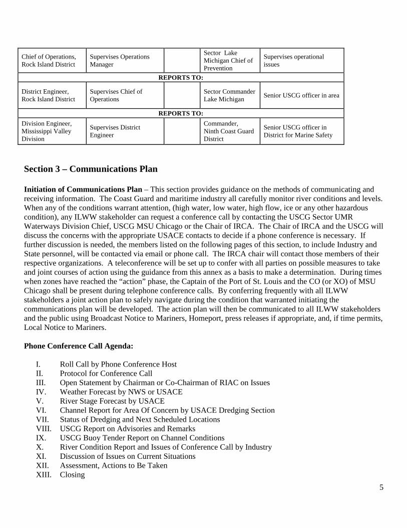
Chief of Operations, Rock Island District
Supervises Operations Manager
Sector Lake Michigan Chief of Prevention
Supervises operational issues
REPORTS TO:
District Engineer, Rock Island District
Supervises Chief of Operations Sector Commander
Lake Michigan Senior USCG officer in area
REPORTS TO: Division Engineer, Mississippi Valley Division
Supervises District Engineer
Commander, Ninth Coast Guard District
Senior USCG officer in District for Marine Safety
Section 3 – Communications Plan Initiation of Communications Plan – This section provides guidance on the methods of communicating and receiving information. The Coast Guard and maritime industry all carefully monitor river conditions and levels. When any of the conditions warrant attention, (high water, low water, high flow, ice or any other hazardous condition), any ILWW stakeholder can request a conference call by contacting the USCG Sector UMR Waterways Division Chief, USCG MSU Chicago or the Chair of IRCA. The Chair of IRCA and the USCG will discuss the concerns with the appropriate USACE contacts to decide if a phone conference is necessary. If further discussion is needed, the members listed on the following pages of this section, to include Industry and State personnel, will be contacted via email or phone call. The IRCA chair will contact those members of their respective organizations. A teleconference will be set up to confer with all parties on possible measures to take and joint courses of action using the guidance from this annex as a basis to make a determination. During times when zones have reached the “action” phase, the Captain of the Port of St. Louis and the CO (or XO) of MSU Chicago shall be present during telephone conference calls. By conferring frequently with all ILWW stakeholders a joint action plan to safely navigate during the condition that warranted initiating the communications plan will be developed. The action plan will then be communicated to all ILWW stakeholders and the public using Broadcast Notice to Mariners, Homeport, press releases if appropriate, and, if time permits, Local Notice to Mariners. Phone Conference Call Agenda:
I. Roll Call by Phone Conference Host II. Protocol for Conference Call III. Open Statement by Chairman or Co-Chairman of RIAC on Issues IV. Weather Forecast by NWS or USACE V. River Stage Forecast by USACE VI. Channel Report for Area Of Concern by USACE Dredging Section VII. Status of Dredging and Next Scheduled Locations VIII. USCG Report on Advisories and Remarks IX. USCG Buoy Tender Report on Channel Conditions X. River Condition Report and Issues of Conference Call by Industry XI. Discussion of Issues on Current Situations XII. Assessment, Actions to Be Taken XIII. Closing
6
All Agencies & Organizations: To ensure effective interagency cooperation during periods of coordinated response to high and low water, or other hazardous river conditions, stakeholder organizations are advised to maintain active and ongoing communications with one another during normal river conditions and while planning together for joint response activities. This will greatly facilitate speedy and effective communications under the pressure of responding to an event. Vessel to Vessel and Vessel to Shore Communications: VHF communications on the ILWW are handled by the communications centers at the Sector Upper Mississippi River Command Center and Sector Lake Michigan Integrated Command Center. Sector UMR Command Center is located in the Robert A. Young Federal Building in St. Louis, MO. Sector UMR Command Center is responsible for receiving information on the ILR mile markers 0-187.0 Sector Lake Michigan Command Center is located in Milwaukee, WI and can be reached by phone at (414) 747-7182. Sector Lake Michigan Command Center is responsible for receiving information on the ILR mile markers 187.1-333.5. NOTIFICATIONS: U. S. Coast Guard: The U. S. Coast Guard maintains a 24 x 7 live watch at its Command Centers in St. Louis, MO and Milwaukee, WI. Hazardous river conditions are monitored by Command Center personnel, as well as the Sector Duty Officers at both the St. Louis, MO and Milwaukee, WI Command Centers and reported as appropriate to the Sector Commanders. As conditions dictate, the Command Centers will release Broadcast Notices to Mariners (BNM) or Urgent Marine Information Broadcasts (UMIB) with safety advisories, safety zones, or river closures. As noted above, these waterways control measures are determined in consultation with the USACE and representative of the river industry. USCG Sector Upper Mississippi River Command Center (24 hr.) (314) 269-2332 Commander (314) 269-2600 Prevention Chief (314) 269-2568 Waterways Management Division Chief (314) 269-2560 Waterways Management Duty (24 hr.) (319) 520-8556 MSD Peoria Supervisor (309) 694-7779 USCG MSU Chicago Sector Lake Michigan Command Center (24 hr.) (414) 747-7182 Commander (630) 986-2126 Waterways Management Division Chief (630) 986-2131
7
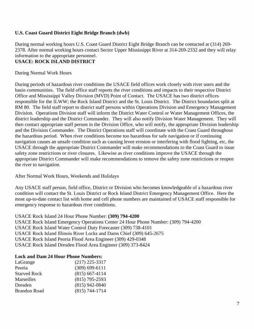
U.S. Coast Guard District Eight Bridge Branch (dwb) During normal working hours U.S. Coast Guard District Eight Bridge Branch can be contacted at (314) 269-2378. After normal working hours contact Sector Upper Mississippi River at 314-269-2332 and they will relay information to the appropriate personnel. USACE: ROCK ISLAND DISTRICT During Normal Work Hours During periods of hazardous river conditions the USACE field offices work closely with river users and the basin communities. The field office staff reports the river conditions and impacts to their respective District Office and Mississippi Valley Division (MVD) Point of Contact. The USACE has two district offices responsible for the ILWW; the Rock Island District and the St. Louis District. The District boundaries split at RM 80. The field staff report to district staff persons within Operations Division and Emergency Management Division. Operations Division staff will inform the District Water Control or Water Management Offices, the district leadership and the District Commander. They will also notify Division Water Management. They will then contact appropriate staff person in the Division Office, who will notify, the appropriate Division leadership and the Division Commander. The District Operations staff will coordinate with the Coast Guard throughout the hazardous period. When river conditions become too hazardous for safe navigation or if continuing navigation causes an unsafe condition such as causing levee erosion or interfering with flood fighting, etc, the USACE through the appropriate District Commander will make recommendations to the Coast Guard to issue safety zone restrictions or river closures. Likewise as river conditions improve the USACE through the appropriate District Commander will make recommendations to remove the safety zone restrictions or reopen the river to navigation. After Normal Work Hours, Weekends and Holidays Any USACE staff person, field office, District or Division who becomes knowledgeable of a hazardous river condition will contact the St. Louis District or Rock Island District Emergency Management Office. Here the most up-to-date contact list with home and cell phone numbers are maintained of USACE staff responsible for emergency response to hazardous river conditions. USACE Rock Island 24 Hour Phone Number: (309) 794-4200 USACE Rock Island Emergency Operations Center 24 Hour Phone Number: (309) 794-4200 USACE Rock Island Water Control Duty Forecaster (309) 738-4101 USACE Rock Island Illinois River Locks and Dams Chief (309) 645-2675 USACE Rock Island Peoria Flood Area Engineer (309) 429-0348 USACE Rock Island Dresden Flood Area Engineer (309) 373-8424 Lock and Dam 24 Hour Phone Numbers: LaGrange (217) 225-3317 Peoria (309) 699-6111 Starved Rock (815) 667-4114 Marseilles (815) 795-2593 Dresden (815) 942-0840 Brandon Road (815) 744-1714
8
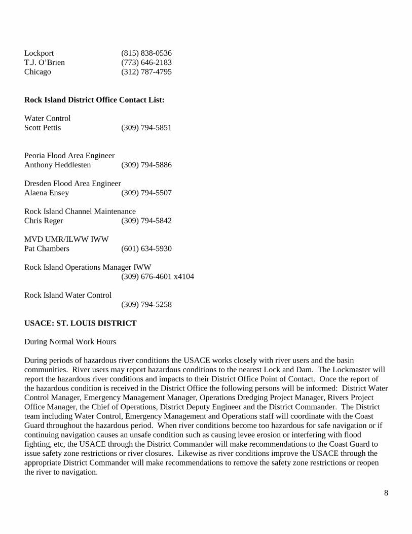
Lockport (815) 838-0536 T.J. O’Brien (773) 646-2183 Chicago (312) 787-4795 Rock Island District Office Contact List: Water Control Scott Pettis (309) 794-5851 Peoria Flood Area Engineer Anthony Heddlesten (309) 794-5886
Dresden Flood Area Engineer Alaena Ensey (309) 794-5507 Rock Island Channel Maintenance Chris Reger (309) 794-5842 MVD UMR/ILWW IWW Pat Chambers (601) 634-5930 Rock Island Operations Manager IWW (309) 676-4601 x4104 Rock Island Water Control (309) 794-5258 USACE: ST. LOUIS DISTRICT During Normal Work Hours During periods of hazardous river conditions the USACE works closely with river users and the basin communities. River users may report hazardous conditions to the nearest Lock and Dam. The Lockmaster will report the hazardous river conditions and impacts to their District Office Point of Contact. Once the report of the hazardous condition is received in the District Office the following persons will be informed: District Water Control Manager, Emergency Management Manager, Operations Dredging Project Manager, Rivers Project Office Manager, the Chief of Operations, District Deputy Engineer and the District Commander. The District team including Water Control, Emergency Management and Operations staff will coordinate with the Coast Guard throughout the hazardous period. When river conditions become too hazardous for safe navigation or if continuing navigation causes an unsafe condition such as causing levee erosion or interfering with flood fighting, etc, the USACE through the District Commander will make recommendations to the Coast Guard to issue safety zone restrictions or river closures. Likewise as river conditions improve the USACE through the appropriate District Commander will make recommendations to remove the safety zone restrictions or reopen the river to navigation.
9
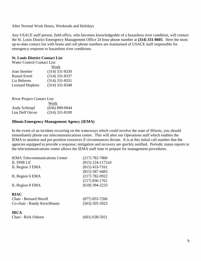
After Normal Work Hours, Weekends and Holidays Any USACE staff person, field office, who becomes knowledgeable of a hazardous river condition, will contact the St. Louis District Emergency Management Office 24 hour phone number at (314) 331-8605. Here the most up-to-date contact list with home and cell phone numbers are maintained of USACE staff responsible for emergency response to hazardous river conditions. St. Louis District Contact List Water Control Contact List:
Work Joan Stemler (314) 331-8330 Russel Errett (314) 331-8337 Liz Behrens (314) 331-8351 Leonard Hopkins (314) 331-8348 River Project Contact List:
Work Andy Schimpf (636) 899-0044 Lou Dell’Orcoo (314) 331-8100 Illinois Emergency Management Agency (IEMA) In the event of an incident occurring on the waterways which could involve the state of Illinois, you should immediately phone our telecommunications center. This will alert our Operations staff which enables the IEMA to monitor and pre-position resources if circumstances dictate. It is at this initial call number that the agencies equipped to provide a response; mitigation and recovery are quickly notified. Periodic status reports to the telecommunications center allows the IEMA staff time to prepare for management procedures. IEMA Telecommunications Center (217) 782-7860 IL DNR LE (815) 224-1172x0 IL Region 3 EMA (815) 433-7161 (815) 587-4483 IL Region 6 EMA (217) 782-0922 (217) 836-1761 IL Region 8 EMA (618) 394-2233 RIAC Chair - Bernard Heroff (877) 855-7266 Co-chair - Randy Kirschbaum (563) 505-5923 IRCA Chari - Rick Osborn (601) 638-5921
10
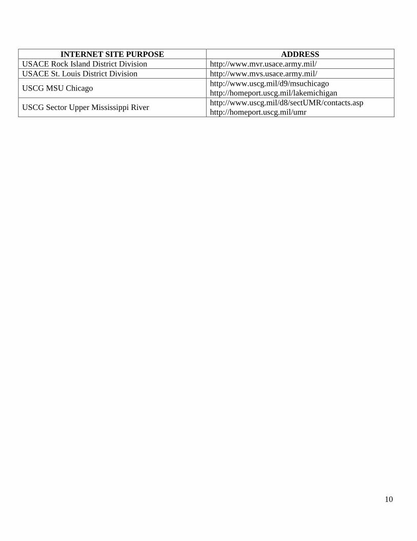
INTERNET SITE PURPOSE ADDRESS USACE Rock Island District Division http://www.mvr.usace.army.mil/ USACE St. Louis District Division http://www.mvs.usace.army.mil/
USCG MSU Chicago http://www.uscg.mil/d9/msuchicago http://homeport.uscg.mil/lakemichigan
USCG Sector Upper Mississippi River http://www.uscg.mil/d8/sectUMR/contacts.asp http://homeport.uscg.mil/umr
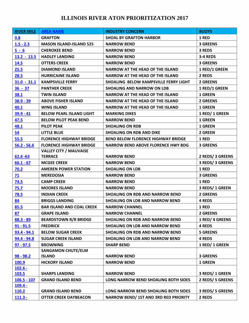
ILLINOIS RIVER ATON PRIORITIZATION 2017 RIVER MILE AREA NAME INDUSTRY CONCERN BUOYS 0.8 GRAFTON SHOAL BY GRAFTON HARBOR 1 RED 1.5 - 2.3 MASON ISLAND-ISLAND 525 NARROW BEND 3 GREENS 5 - 6 CHEROKEE BEND NARROW BEND 3 REDS 13.2 - 13.5 HADLEY LANDING NARROW BEND 3-4 REDS 14.5 OTTERS CREEK NARROW BEND 3 GREENS 25.5 DIAMOND ISLAND NARROW AT THE HEAD OF THE ISLAND 1 RED/1 GREEN 28.5 HURRICAINE ISLAND NARROW AT THE HEAD OF THE ISLAND 2 REDS 31.0 - 31.1 KAMPSVILLE FERRY SHOALING BELOW KAMPSVILLE FERRY LIGHT 2 GREENS 36 - 37 PANTHER CREEK SHOALING AND NARROW ON LDB 1 RED/1 GREEN 38.1 TWIN ISLAND NARROW AT THE HEAD OF THE ISLAND 1 GREEN 38.9 - 39 ABOVE FISHER ISLAND NARROW AT THE HEAD OF THE ISLAND 2 GREENS 40.1 WING ISLAND NARROW AT THE HEAD OF THE ISLAND 1 GREEN 39.9 - 41 BELOW PEARL ISLAND LIGHT MARKING DIKES 1 RED/ 1 GREEN 47.5 BELOW PILOT PEAK BEND NARROW BEND 1 GREEN 48.1 PILOT PEAK SHOALING ON RDB 1 GREEN 54 LITTLE BLUE SHOALING ON RDB AND DIKE 2 GREEN 55.5 FLORENCE HIGHWAY BRIDGE BEND BELOW FLORENCE HIGHWAY BRIDGE 1 RED 56.2 - 56.6 FLORENCE HIGHWAY BRIDGE NARROW BEND ABOVE FLORENCE HWY BDG 3 GREENS
62.6 -63 VALLEY CITY / MAUVAISE TERRACE NARROW BEND 2 REDS/ 3 GREENS
66.1 - 67 MCGEE CREEK NARROW BEND 3 REDS/ 3 GREENS 70.2 AMEREN POWER STATION SHOALING ON LDB 1 RED 71 MEREDOSIA NARROW BEND 3 GREENS 74.5 CAMP CREEK NARROW BEND 1 RED 75.7 MOORES ISLAND NARROW BEND 3 REDS/ 1 GREEN 78.5 INDIAN CREEK SHOALING ON RDB AND NARROW BEND 2 GREENS 84 BRIGGS LANDING SHOALING ON LDB AND NARROW BEND 4 REDS 85.5 BAR ISLAND AND COAL CREEK NARROW CHANNEL 1 RED 87 GRAPE ISLAND NARROW CHANNEL 2 GREENS 88.3 - 89 BEARDSTOWN R/R BRIDGE SHOALING ON RDB AND NARROW BEND 1 RED/ 4 GREENS 91 - 91.5 FREDRICK SHOALING ON LDB AND NARROW BEND 4 REDS 93.4 - 94.1 BELOW SUGAR CREEK SHOALING ON RDB AND NARROW BEND 5 GREENS 94.4 - 94.8 SUGAR CREEK ISLAND SHOALING ON LDB AND NARROW BEND 4 REDS 97 - 97.5 BROWNING SHARP BEND 1 RED/ 1 GREEN
98 - 98.2 SANGAMON CHUTE/ELM ISLAND NARROW BEND 3 GREENS
100.9 HICKORY ISLAND NARROW BEND 1 GREEN 102.6 - 103.5 SHARPS LANDING NARROW BEND 3 REDS/ 1 GREEN 106.5 - 107 GRAND ISLAND BEND LONG NARROW BEND SHOALING BOTH SIDES 2 REDS/ 5 GREENS 109.4 - 110.2 GRAND ISLAND BEND LONG NARROW BEND SHOALING BOTH SIDES 3 REDS/ 5 GREENS 111.3 - OTTER CREEK DAYBEACON NARROW BEND/ 1ST AND 3RD RED PRIORITY 2 REDS
111.4 112.3 OTTER CREEK NARROW BEND/ MIDDLE RED PRIORITY 1 RED 113.4 - 114 HEAD OF GRAND ISLAND NARROW BEND 2 GREENS 114.4 DEVILS ELBOW LOWER NARROW BEND 1 RED 116.5 -116.7 DEVILS ELBOW NARROW BEND SHOALING ON BOTH SIDES 3 REDS 117 HAVANA DAYBEACON NARROW BEND SHOALING ON BOTH SIDES 2 GREENS (LOWER) 120.5 - 121.1 SIEBS LAKE NARROW BEND AROUND QUIVER ISLAND 5 REDS 121.1 - 123 QUIVER BEACH LONG NARROW BEND SHOALING BOTH SIDES 5 GREENS 128.5 - 129.5 LIVERPOOL SHOALING ON RDB AND NARROW BEND 3 REDS/ 4 GREENS 133.8 - 134.5 SPRING LAKE SHOALING ON BOTH SIDES 2 GREENS 135 SENATE ISLAND NARROW BEND SHOALING ON BOTH SIDES 2 REDS 136-137 COPPERAS CREEK SHOALING ON RDB AND NARROW BEND 3 REDS/ 4 GREENS 139 CANTONS LANDING SHOALING LDB 2 REDS 145.5 KINGSTON SHOALING ON LDB AND NARROW BEND 2 REDS 147.2 MACKINAW RIVER LIGHT SHOALING ON BOTH SIDES 1 RED/ 1 GREEN
149.5 - 150 UPPER AND LOWER PEKIN WIGGLE LONG NARROW BEND SHOALING BOTH SIDES 4 REDS/ 4 GREENS
151 PEKIN R/R BRIDGE SHOALING RDB 1 RED 163 - 166 PEORIA LAKE LONG STRETCH OPEN WATER 6 REDS/ 4 GREENS
166.1 - 179 UPPER PEORIA LAKE LONG STRETCH OPEN WATER AND NARROW BENDS
12 REDS/ 10 GREENS
180 - 181.6 CHILLICOTHE ISLAND LONG NARROW BEND SHOALING BOTH SIDES 3 REDS/ 2 GREENS 182 - 183.1 BABBS SLOUGH/ BABBS ISLAND SHOALING ON RDB AND NARROW BEND 2 REDS/ 2 GREENS 189.2 - 190 ABOVE LACON BRIDGE NARROW BEND SHOALING ON BOTH SIDES 3 REDS/ 3 GREENS 193 - 195 HENRY ISLAND LONG NARROW BEND SHOALING BOTH SIDES 4 REDS/ 1 GREEN 196.4 - 197.4 SAWMILL LAKE NARROW BEND SHOALING ON BOTH SIDES 2 REDS/ 5 GREENS 199 - 201 SWAN LAKE/ HALLS LANDING LONG NARROW BEND SHOALING BOTH SIDES 2 REDS/ 5 GREENS 209 - 209.5 HENNEPIN SHOALING ON RDB AND NARROW BEND 4 GREENS 212 - 213.7 HENNEPIN POWER STATION NARROW BEND SHOALING ON BOTH SIDES 5 REDS/ 5 GREENS
214 - 218 CLARK ISLAND TO SPRING VALLEY LONG NARROW BEND SHOALING BOTH SIDES 8 REDS/ 6 GREENS
219.8 - 220.2 HUGHES SLOUGH SHOALING ON RDB AND NARROW BEND 3 GREENS 225.5 - 229 LASALLE TO UTICA LONG NARROW BEND SHOALING BOTH SIDES 7 REDS/ 7 GREENS 230 - 231 BELOW STARVED ROCK L/D NARROW CHANNEL 2 REDS/ 3 GREENS 231.1 - 233 ABOVE STARVED ROCK L/D NARROW CHANNEL SHOALING BOTH SIDES 4 REDS/ 5 GREENS 242 -244 BELOW MARSEILLES L/D LONG NARROW BEND SHOALING BOTH SIDES 6 REDS/ 6 GREENS 249 - 250 KICKAPOO LONG NARROW BEND SHOALING BOTH SIDES 3 REDS/ 5 GREENS 258.5 - 259.5 GRIST ISLAND NARROW CHANNEL 3 REDS/ 4 GREENS 273.5 - 274.7 CHANNAHON SHOALING ON RDB AND NARROW BEND 4 REDS/ 5 GREENS 280.9 -282 JOLIET SHOALING ON LDB AND NARROW BEND 5 REDS/ 2 GREENS
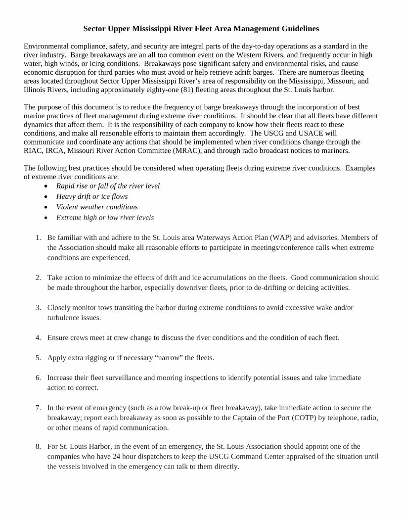
Sector Upper Mississippi River Fleet Area Management Guidelines
Environmental compliance, safety, and security are integral parts of the day-to-day operations as a standard in the river industry. Barge breakaways are an all too common event on the Western Rivers, and frequently occur in high water, high winds, or icing conditions. Breakaways pose significant safety and environmental risks, and cause economic disruption for third parties who must avoid or help retrieve adrift barges. There are numerous fleeting areas located throughout Sector Upper Mississippi River’s area of responsibility on the Mississippi, Missouri, and Illinois Rivers, including approximately eighty-one (81) fleeting areas throughout the St. Louis harbor. The purpose of this document is to reduce the frequency of barge breakaways through the incorporation of best marine practices of fleet management during extreme river conditions. It should be clear that all fleets have different dynamics that affect them. It is the responsibility of each company to know how their fleets react to these conditions, and make all reasonable efforts to maintain them accordingly. The USCG and USACE will communicate and coordinate any actions that should be implemented when river conditions change through the RIAC, IRCA, Missouri River Action Committee (MRAC), and through radio broadcast notices to mariners. The following best practices should be considered when operating fleets during extreme river conditions. Examples of extreme river conditions are:
• Rapid rise or fall of the river level • Heavy drift or ice flows • Violent weather conditions • Extreme high or low river levels
1. Be familiar with and adhere to the St. Louis area Waterways Action Plan (WAP) and advisories. Members of the Association should make all reasonable efforts to participate in meetings/conference calls when extreme conditions are experienced.
2. Take action to minimize the effects of drift and ice accumulations on the fleets. Good communication should be made throughout the harbor, especially downriver fleets, prior to de-drifting or deicing activities.
3. Closely monitor tows transiting the harbor during extreme conditions to avoid excessive wake and/or turbulence issues.
4. Ensure crews meet at crew change to discuss the river conditions and the condition of each fleet.
5. Apply extra rigging or if necessary “narrow” the fleets.
6. Increase their fleet surveillance and mooring inspections to identify potential issues and take immediate action to correct.
7. In the event of emergency (such as a tow break-up or fleet breakaway), take immediate action to secure the breakaway; report each breakaway as soon as possible to the Captain of the Port (COTP) by telephone, radio, or other means of rapid communication.
8. For St. Louis Harbor, in the event of an emergency, the St. Louis Association should appoint one of the
companies who have 24 hour dispatchers to keep the USCG Command Center appraised of the situation until the vessels involved in the emergency can talk to them directly.
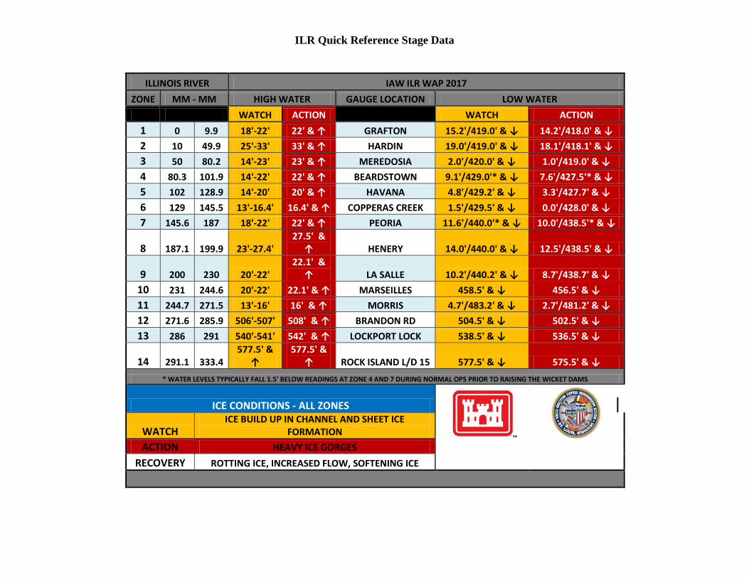
ILR Quick Reference Stage Data
ILLINOIS RIVER IAW ILR WAP 2017
ZONE MM - MM HIGH WATER GAUGE LOCATION LOW WATER
ZONE MM - MM WATCH ACTION
WATCH ACTION
1 0 9.9 18'-22' 22' & ↑ GRAFTON 15.2'/419.0' & ↓ 14.2'/418.0' & ↓
2 10 49.9 25'-33' 33' & ↑ HARDIN 19.0'/419.0' & ↓ 18.1'/418.1' & ↓
3 50 80.2 14'-23' 23' & ↑ MEREDOSIA 2.0'/420.0' & ↓ 1.0'/419.0' & ↓
4 80.3 101.9 14'-22' 22' & ↑ BEARDSTOWN 9.1'/429.0'* & ↓ 7.6'/427.5'* & ↓
5 102 128.9 14'-20' 20' & ↑ HAVANA 4.8'/429.2' & ↓ 3.3'/427.7' & ↓
6 129 145.5 13'-16.4' 16.4' & ↑ COPPERAS CREEK 1.5'/429.5' & ↓ 0.0'/428.0' & ↓
7 145.6 187 18'-22' 22' & ↑ PEORIA 11.6'/440.0'* & ↓ 10.0'/438.5'* & ↓
8 187.1 199.9 23'-27.4'
27.5' & ↑ HENERY 14.0'/440.0' & ↓ 12.5'/438.5' & ↓
9 200 230 20'-22'
22.1' & ↑ LA SALLE 10.2'/440.2' & ↓ 8.7'/438.7' & ↓
10 231 244.6 20'-22' 22.1' & ↑ MARSEILLES 458.5' & ↓ 456.5' & ↓
11 244.7 271.5 13'-16' 16' & ↑ MORRIS 4.7'/483.2' & ↓ 2.7'/481.2' & ↓
12 271.6 285.9 506'-507' 508' & ↑ BRANDON RD 504.5' & ↓ 502.5' & ↓
13 286 291 540'-541' 542' & ↑ LOCKPORT LOCK 538.5' & ↓ 536.5' & ↓
14 291.1 333.4
577.5' & ↑
577.5' & ↑ ROCK ISLAND L/D 15 577.5' & ↓ 575.5' & ↓
* WATER LEVELS TYPICALLY FALL 1.5' BELOW READINGS AT ZONE 4 AND 7 DURING NORMAL OPS PRIOR TO RAISING THE WICKET DAMS
ICE CONDITIONS - ALL ZONES
WATCH
ICE BUILD UP IN CHANNEL AND SHEET ICE FORMATION
ACTION HEAVY ICE GORGES
RECOVERY ROTTING ICE, INCREASED FLOW, SOFTENING ICE
Section 4 – Action Plan The actions to be taken during High Water, Low Water, High Current, and Ice conditions are described in the following Action Plan Tables. ACTION PLAN TABLE
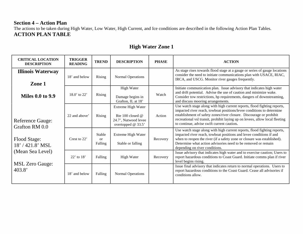
High Water Zone 1
CRITICAL LOCATION
DESCRIPTION TRIGGER READING TREND DESCRIPTION PHASE ACTION
Illinois Waterway
Zone 1
Miles 0.0 to 9.9
Reference Gauge: Grafton RM 0.0 Flood Stage: 18’ / 421.8’ MSL (Mean Sea Level) MSL Zero Gauge: 403.8’
18’ and below Rising Normal Operations
As stage rises towards flood stage at a gauge or series of gauge locations consider the need to initiate communications plan with USACE, RIAC, IRCA, and USCG. Monitor river gauges frequently.
18.0’ to 22’ Rising
High Water
Damage begins in Grafton, IL at 18’
Watch
Initiate communication plan. Issue advisory that indicates high water and drift potential. Advise the use of caution and minimize wake. Consider tow restrictions, hp requirements, dangers of downstreaming, and discuss mooring arrangements.
22 and above’ Rising
Extreme High Water
Rte 100 closed @ 24.7’, Nutwood levee overtopped @ 33.5’
Action
Use watch stage along with high current reports, flood fighting reports, impacted river reach, towboat positions/levee conditions to determine establishment of safety zones/river closure. Discourage or prohibit recreational vsl transit, prohibit laying up on levees, allow local fleeting to continue, advise swift current caution.
Crest to 22’ Stable
or Falling
Extreme High Water
Stable or falling Recovery
Use watch stage along with high current reports, flood fighting reports, impacted river reach, towboat positions and levee conditions if and when to reopen the river (if a safety zone or closure was established). Determine what action advisories need to be removed or remain depending on river conditions.
22’ to 18’ Falling High Water Recovery Issue advisory that indicates high water and to exercise caution; Users to report hazardous conditions to Coast Guard. Initiate comms plan if river level begins rising.
18’ and below Falling Normal Operations
Issue final advisory that indicates return to normal operations. Users to report hazardous conditions to the Coast Guard. Cease all advisories if conditions allow.
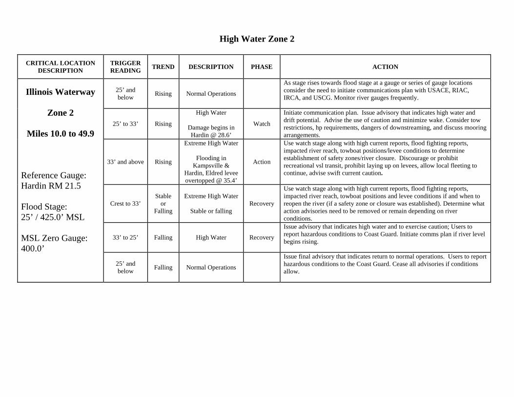
High Water Zone 2
CRITICAL LOCATION
DESCRIPTION TRIGGER READING TREND DESCRIPTION PHASE ACTION
Illinois Waterway
Zone 2
Miles 10.0 to 49.9
Reference Gauge: Hardin RM 21.5 Flood Stage: 25’ / 425.0’ MSL MSL Zero Gauge: 400.0’
25’ and below Rising Normal Operations
As stage rises towards flood stage at a gauge or series of gauge locations consider the need to initiate communications plan with USACE, RIAC, IRCA, and USCG. Monitor river gauges frequently.
25’ to 33’ Rising
High Water
Damage begins in Hardin @ 28.6’
Watch
Initiate communication plan. Issue advisory that indicates high water and drift potential. Advise the use of caution and minimize wake. Consider tow restrictions, hp requirements, dangers of downstreaming, and discuss mooring arrangements.
33’ and above Rising
Extreme High Water
Flooding in Kampsville &
Hardin, Eldred levee overtopped @ 35.4’
Action
Use watch stage along with high current reports, flood fighting reports, impacted river reach, towboat positions/levee conditions to determine establishment of safety zones/river closure. Discourage or prohibit recreational vsl transit, prohibit laying up on levees, allow local fleeting to continue, advise swift current caution.
Crest to 33’ Stable
or Falling
Extreme High Water
Stable or falling Recovery
Use watch stage along with high current reports, flood fighting reports, impacted river reach, towboat positions and levee conditions if and when to reopen the river (if a safety zone or closure was established). Determine what action advisories need to be removed or remain depending on river conditions.
33’ to 25’ Falling High Water Recovery
Issue advisory that indicates high water and to exercise caution; Users to report hazardous conditions to Coast Guard. Initiate comms plan if river level begins rising.
25’ and below Falling Normal Operations
Issue final advisory that indicates return to normal operations. Users to report hazardous conditions to the Coast Guard. Cease all advisories if conditions allow.
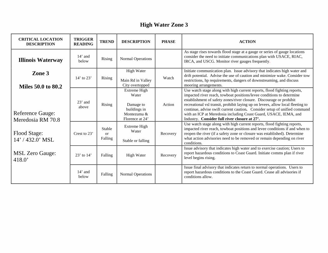
High Water Zone 3
CRITICAL LOCATION DESCRIPTION
TRIGGER READING TREND DESCRIPTION PHASE ACTION
Illinois Waterway
Zone 3
Miles 50.0 to 80.2
Reference Gauge: Meredosia RM 70.8 Flood Stage: 14’ / 432.0’ MSL MSL Zero Gauge: 418.0’
14’ and below Rising Normal Operations
As stage rises towards flood stage at a gauge or series of gauge locations consider the need to initiate communications plan with USACE, RIAC, IRCA, and USCG. Monitor river gauges frequently.
14’ to 23’ Rising
High Water
Main Rd in Valley City overtopped
Watch
Initiate communication plan. Issue advisory that indicates high water and drift potential. Advise the use of caution and minimize wake. Consider tow restrictions, hp requirements, dangers of downstreaming, and discuss mooring arrangements.
23’ and above Rising
Extreme High Water
Damage to buildings in
Montezuma & Florence at 24’
Action
Use watch stage along with high current reports, flood fighting reports, impacted river reach, towboat positions/levee conditions to determine establishment of safety zones/river closure. Discourage or prohibit recreational vsl transit, prohibit laying up on levees, allow local fleeting to continue, advise swift current caution. Consider setup of unified command with an ICP at Meredosia including Coast Guard, USACE, IEMA, and Industry. Consider full river closure at 27’.
Crest to 23’ Stable
or Falling
Extreme High Water
Stable or falling
Recovery
Use watch stage along with high current reports, flood fighting reports, impacted river reach, towboat positions and levee conditions if and when to reopen the river (if a safety zone or closure was established). Determine what action advisories need to be removed or remain depending on river conditions.
23’ to 14’ Falling High Water Recovery
Issue advisory that indicates high water and to exercise caution; Users to report hazardous conditions to Coast Guard. Initiate comms plan if river level begins rising.
14’ and below Falling Normal Operations
Issue final advisory that indicates return to normal operations. Users to report hazardous conditions to the Coast Guard. Cease all advisories if conditions allow.
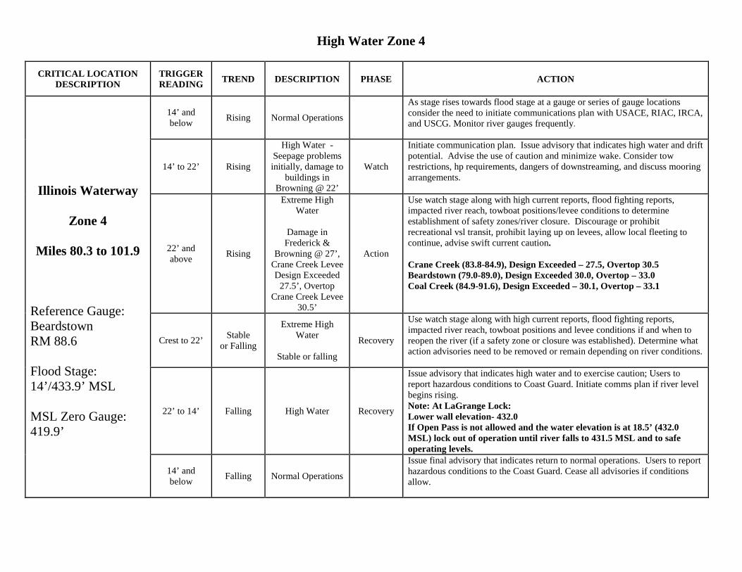
High Water Zone 4
CRITICAL LOCATION DESCRIPTION
TRIGGER READING TREND DESCRIPTION PHASE ACTION
14’ and below Rising Normal Operations
As stage rises towards flood stage at a gauge or series of gauge locations consider the need to initiate communications plan with USACE, RIAC, IRCA, and USCG. Monitor river gauges frequently.
Illinois Waterway
Zone 4
Miles 80.3 to 101.9
Reference Gauge: Beardstown RM 88.6 Flood Stage: 14’/433.9’ MSL MSL Zero Gauge: 419.9’
14’ to 22’ Rising
High Water -Seepage problems initially, damage to
buildings in Browning @ 22’
Watch
Initiate communication plan. Issue advisory that indicates high water and drift potential. Advise the use of caution and minimize wake. Consider tow restrictions, hp requirements, dangers of downstreaming, and discuss mooring arrangements.
22’ and above Rising
Extreme High Water
Damage in
Frederick & Browning @ 27’,
Crane Creek Levee Design Exceeded
27.5’, Overtop Crane Creek Levee
30.5’
Action
Use watch stage along with high current reports, flood fighting reports, impacted river reach, towboat positions/levee conditions to determine establishment of safety zones/river closure. Discourage or prohibit recreational vsl transit, prohibit laying up on levees, allow local fleeting to continue, advise swift current caution. Crane Creek (83.8-84.9), Design Exceeded – 27.5, Overtop 30.5 Beardstown (79.0-89.0), Design Exceeded 30.0, Overtop – 33.0 Coal Creek (84.9-91.6), Design Exceeded – 30.1, Overtop – 33.1
Crest to 22’ Stable or Falling
Extreme High Water
Stable or falling
Recovery
Use watch stage along with high current reports, flood fighting reports, impacted river reach, towboat positions and levee conditions if and when to reopen the river (if a safety zone or closure was established). Determine what action advisories need to be removed or remain depending on river conditions.
22’ to 14’ Falling High Water Recovery
Issue advisory that indicates high water and to exercise caution; Users to report hazardous conditions to Coast Guard. Initiate comms plan if river level begins rising. Note: At LaGrange Lock: Lower wall elevation- 432.0 If Open Pass is not allowed and the water elevation is at 18.5’ (432.0 MSL) lock out of operation until river falls to 431.5 MSL and to safe operating levels.
14’ and below Falling Normal Operations
Issue final advisory that indicates return to normal operations. Users to report hazardous conditions to the Coast Guard. Cease all advisories if conditions allow.
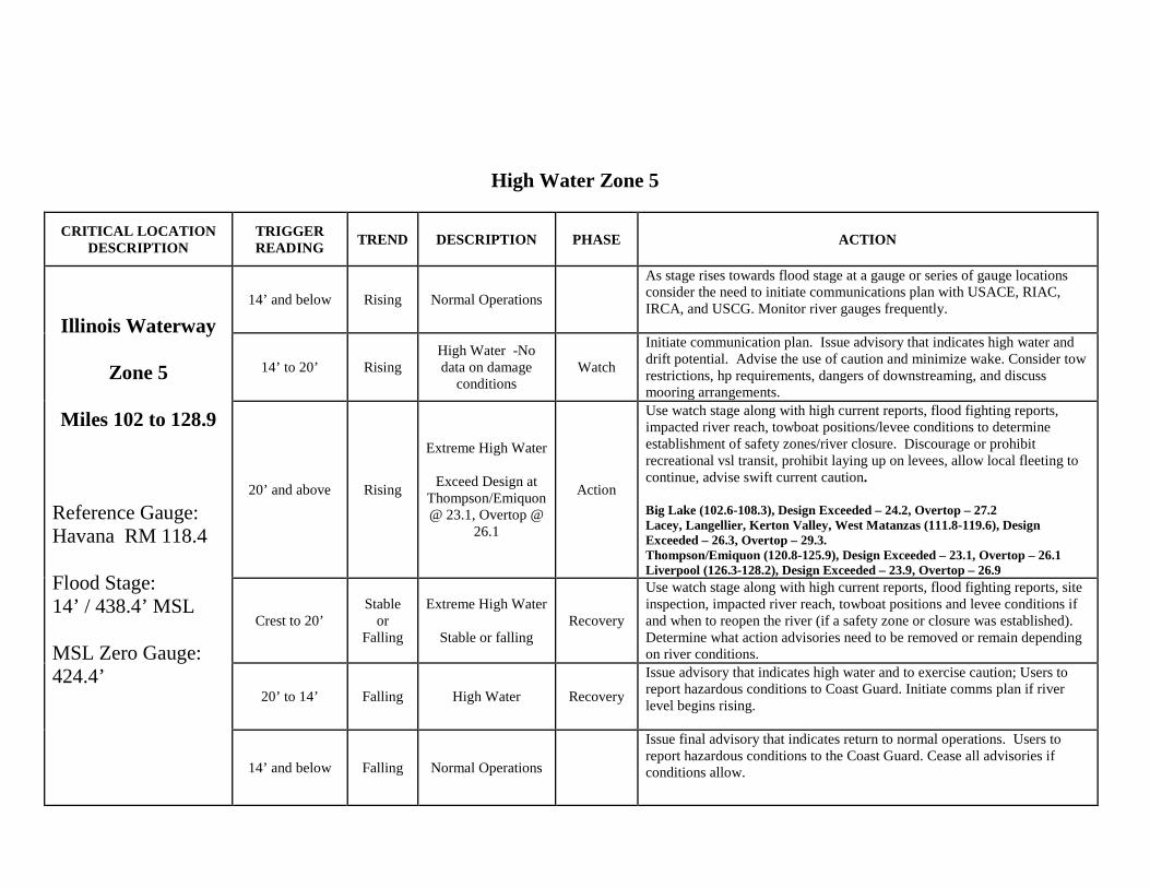
High Water Zone 5
CRITICAL LOCATION DESCRIPTION
TRIGGER READING TREND DESCRIPTION PHASE ACTION
Illinois Waterway
Zone 5
Miles 102 to 128.9
Reference Gauge: Havana RM 118.4 Flood Stage: 14’ / 438.4’ MSL MSL Zero Gauge: 424.4’
14’ and below Rising Normal Operations
As stage rises towards flood stage at a gauge or series of gauge locations consider the need to initiate communications plan with USACE, RIAC, IRCA, and USCG. Monitor river gauges frequently.
14’ to 20’ Rising High Water -No data on damage
conditions Watch
Initiate communication plan. Issue advisory that indicates high water and drift potential. Advise the use of caution and minimize wake. Consider tow restrictions, hp requirements, dangers of downstreaming, and discuss mooring arrangements.
20’ and above Rising
Extreme High Water
Exceed Design at Thompson/Emiquon @ 23.1, Overtop @
26.1
Action
Use watch stage along with high current reports, flood fighting reports, impacted river reach, towboat positions/levee conditions to determine establishment of safety zones/river closure. Discourage or prohibit recreational vsl transit, prohibit laying up on levees, allow local fleeting to continue, advise swift current caution. Big Lake (102.6-108.3), Design Exceeded – 24.2, Overtop – 27.2 Lacey, Langellier, Kerton Valley, West Matanzas (111.8-119.6), Design Exceeded – 26.3, Overtop – 29.3. Thompson/Emiquon (120.8-125.9), Design Exceeded – 23.1, Overtop – 26.1 Liverpool (126.3-128.2), Design Exceeded – 23.9, Overtop – 26.9
Crest to 20’ Stable
or Falling
Extreme High Water
Stable or falling Recovery
Use watch stage along with high current reports, flood fighting reports, site inspection, impacted river reach, towboat positions and levee conditions if and when to reopen the river (if a safety zone or closure was established). Determine what action advisories need to be removed or remain depending on river conditions.
20’ to 14’ Falling High Water Recovery
Issue advisory that indicates high water and to exercise caution; Users to report hazardous conditions to Coast Guard. Initiate comms plan if river level begins rising.
14’ and below Falling Normal Operations
Issue final advisory that indicates return to normal operations. Users to report hazardous conditions to the Coast Guard. Cease all advisories if conditions allow.
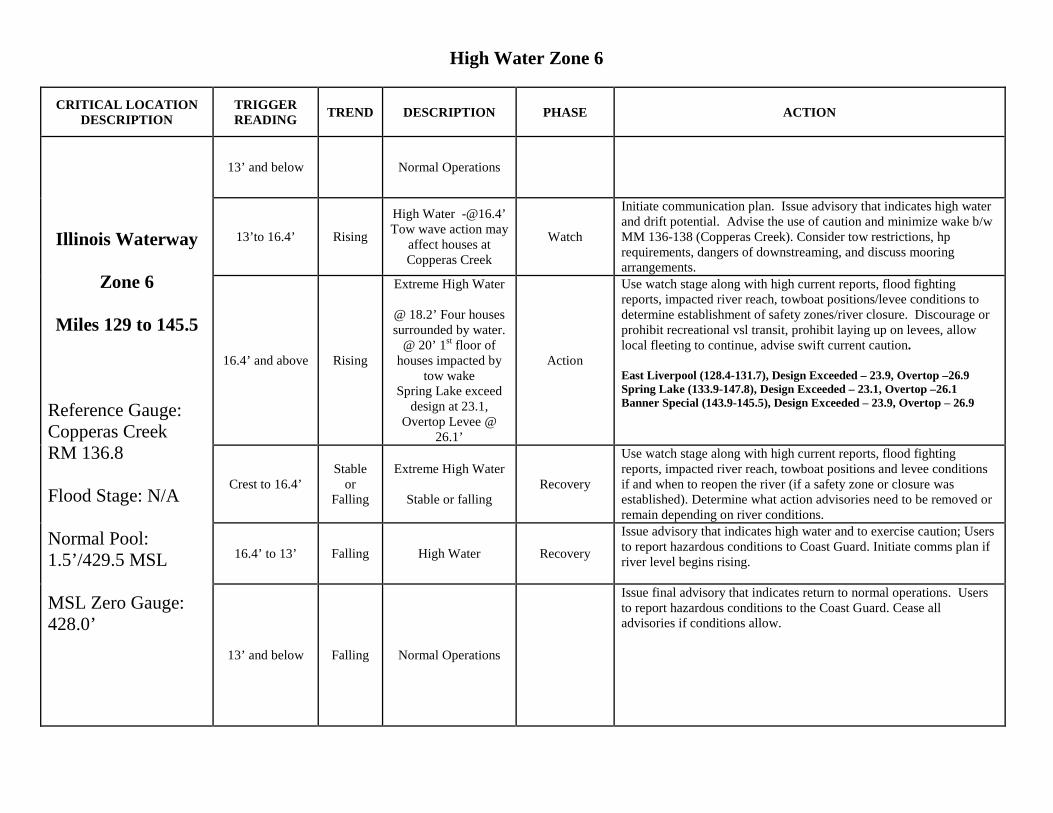
High Water Zone 6
CRITICAL LOCATION DESCRIPTION
TRIGGER READING TREND DESCRIPTION PHASE ACTION
Illinois Waterway
Zone 6
Miles 129 to 145.5
Reference Gauge: Copperas Creek RM 136.8 Flood Stage: N/A Normal Pool: 1.5’/429.5 MSL MSL Zero Gauge: 428.0’
13’ and below Normal Operations
13’to 16.4’ Rising
High Water [email protected]’ Tow wave action may
affect houses at Copperas Creek
Watch
Initiate communication plan. Issue advisory that indicates high water and drift potential. Advise the use of caution and minimize wake b/w MM 136-138 (Copperas Creek). Consider tow restrictions, hp requirements, dangers of downstreaming, and discuss mooring arrangements.
16.4’ and above Rising
Extreme High Water
@ 18.2’ Four houses surrounded by water.
@ 20’ 1st floor of houses impacted by
tow wake Spring Lake exceed
design at 23.1, Overtop Levee @
26.1’
Action
Use watch stage along with high current reports, flood fighting reports, impacted river reach, towboat positions/levee conditions to determine establishment of safety zones/river closure. Discourage or prohibit recreational vsl transit, prohibit laying up on levees, allow local fleeting to continue, advise swift current caution. East Liverpool (128.4-131.7), Design Exceeded – 23.9, Overtop –26.9 Spring Lake (133.9-147.8), Design Exceeded – 23.1, Overtop –26.1 Banner Special (143.9-145.5), Design Exceeded – 23.9, Overtop – 26.9
Crest to 16.4’ Stable
or Falling
Extreme High Water
Stable or falling Recovery
Use watch stage along with high current reports, flood fighting reports, impacted river reach, towboat positions and levee conditions if and when to reopen the river (if a safety zone or closure was established). Determine what action advisories need to be removed or remain depending on river conditions.
16.4’ to 13’ Falling High Water Recovery
Issue advisory that indicates high water and to exercise caution; Users to report hazardous conditions to Coast Guard. Initiate comms plan if river level begins rising.
13’ and below Falling Normal Operations
Issue final advisory that indicates return to normal operations. Users to report hazardous conditions to the Coast Guard. Cease all advisories if conditions allow.
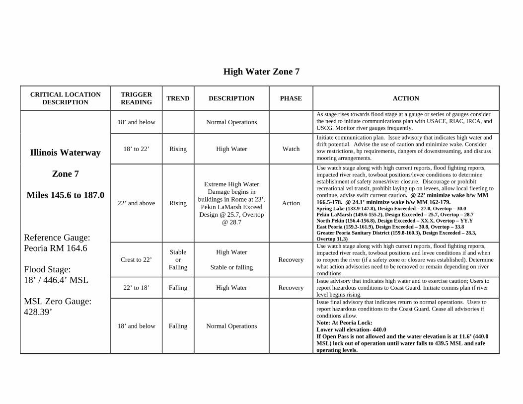
High Water Zone 7
CRITICAL LOCATION DESCRIPTION
TRIGGER READING TREND DESCRIPTION PHASE ACTION
Illinois Waterway
Zone 7
Miles 145.6 to 187.0
Reference Gauge: Peoria RM 164.6 Flood Stage: 18’ / 446.4’ MSL MSL Zero Gauge: 428.39’
18’ and below Normal Operations As stage rises towards flood stage at a gauge or series of gauges consider the need to initiate communications plan with USACE, RIAC, IRCA, and USCG. Monitor river gauges frequently.
18’ to 22’ Rising High Water Watch
Initiate communication plan. Issue advisory that indicates high water and drift potential. Advise the use of caution and minimize wake. Consider tow restrictions, hp requirements, dangers of downstreaming, and discuss mooring arrangements.
22’ and above Rising
Extreme High Water Damage begins in
buildings in Rome at 23’. Pekin LaMarsh Exceed Design @ 25.7, Overtop
@ 28.7
Action
Use watch stage along with high current reports, flood fighting reports, impacted river reach, towboat positions/levee conditions to determine establishment of safety zones/river closure. Discourage or prohibit recreational vsl transit, prohibit laying up on levees, allow local fleeting to continue, advise swift current caution. @ 22’ minimize wake b/w MM 166.5-178. @ 24.1’ minimize wake b/w MM 162-179. Spring Lake (133.9-147.8), Design Exceeded – 27.0, Overtop – 30.0 Pekin LaMarsh (149.6-155.2), Design Exceeded – 25.7, Overtop – 28.7 North Pekin (156.4-156.8), Design Exceeded – XX.X, Overtop – YY.Y East Peoria (159.3-161.9), Design Exceeded – 30.8, Overtop – 33.8 Greater Peoria Sanitary District (159.8-160.3), Design Exceeded – 28.3, Overtop 31.3)
Crest to 22’ Stable
or Falling
High Water
Stable or falling Recovery
Use watch stage along with high current reports, flood fighting reports, impacted river reach, towboat positions and levee conditions if and when to reopen the river (if a safety zone or closure was established). Determine what action advisories need to be removed or remain depending on river conditions.
22’ to 18’ Falling High Water Recovery Issue advisory that indicates high water and to exercise caution; Users to report hazardous conditions to Coast Guard. Initiate comms plan if river level begins rising.
18’ and below Falling Normal Operations
Issue final advisory that indicates return to normal operations. Users to report hazardous conditions to the Coast Guard. Cease all advisories if conditions allow. Note: At Peoria Lock: Lower wall elevation- 440.0 If Open Pass is not allowed and the water elevation is at 11.6’ (440.0 MSL) lock out of operation until water falls to 439.5 MSL and safe operating levels.
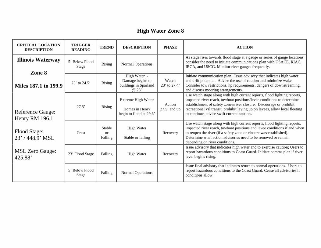
High Water Zone 8
CRITICAL LOCATION DESCRIPTION
TRIGGER READING TREND DESCRIPTION PHASE ACTION
Illinois Waterway
Zone 8
Miles 187.1 to 199.9
Reference Gauge: Henry RM 196.1 Flood Stage: 23’ / 448.9’ MSL MSL Zero Gauge: 425.88’
5’ Below Flood Stage Rising Normal Operations
As stage rises towards flood stage at a gauge or series of gauge locations consider the need to initiate communications plan with USACE, RIAC, IRCA, and USCG. Monitor river gauges frequently.
23’ to 24.5’ Rising
High Water - Damage begins to
buildings in Sparland @ 28’
Watch 23’ to 27.4’
Initiate communication plan. Issue advisory that indicates high water and drift potential. Advise the use of caution and minimize wake. Consider tow restrictions, hp requirements, dangers of downstreaming, and discuss mooring arrangements.
27.5’ Rising
Extreme High Water
Homes in Henry begin to flood at 29.6’
Action 27.5’ and up
Use watch stage along with high current reports, flood fighting reports, impacted river reach, towboat positions/levee conditions to determine establishment of safety zones/river closure. Discourage or prohibit recreational vsl transit, prohibit laying up on levees, allow local fleeting to continue, advise swift current caution.
Crest Stable
or Falling
High Water
Stable or falling Recovery
Use watch stage along with high current reports, flood fighting reports, impacted river reach, towboat positions and levee conditions if and when to reopen the river (if a safety zone or closure was established). Determine what action advisories need to be removed or remain depending on river conditions.
23’ Flood Stage Falling High Water Recovery
Issue advisory that indicates high water and to exercise caution; Users to report hazardous conditions to Coast Guard. Initiate comms plan if river level begins rising.
5’ Below Flood Stage Falling Normal Operations
Issue final advisory that indicates return to normal operations. Users to report hazardous conditions to the Coast Guard. Cease all advisories if conditions allow.
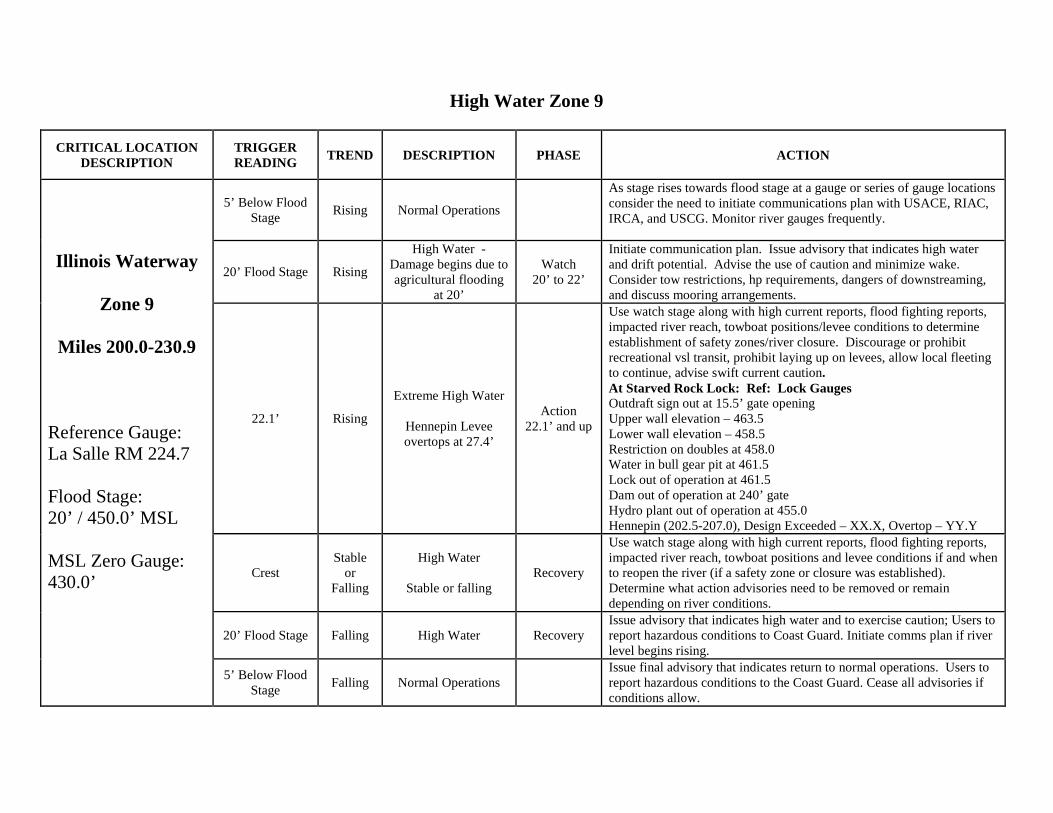
High Water Zone 9
CRITICAL LOCATION DESCRIPTION
TRIGGER READING TREND DESCRIPTION PHASE ACTION
Illinois Waterway
Zone 9
Miles 200.0-230.9
Reference Gauge: La Salle RM 224.7 Flood Stage: 20’ / 450.0’ MSL MSL Zero Gauge: 430.0’
5’ Below Flood Stage Rising Normal Operations
As stage rises towards flood stage at a gauge or series of gauge locations consider the need to initiate communications plan with USACE, RIAC, IRCA, and USCG. Monitor river gauges frequently.
20’ Flood Stage Rising
High Water - Damage begins due to agricultural flooding
at 20’
Watch 20’ to 22’
Initiate communication plan. Issue advisory that indicates high water and drift potential. Advise the use of caution and minimize wake. Consider tow restrictions, hp requirements, dangers of downstreaming, and discuss mooring arrangements.
22.1’ Rising
Extreme High Water
Hennepin Levee overtops at 27.4’
Action 22.1’ and up
Use watch stage along with high current reports, flood fighting reports, impacted river reach, towboat positions/levee conditions to determine establishment of safety zones/river closure. Discourage or prohibit recreational vsl transit, prohibit laying up on levees, allow local fleeting to continue, advise swift current caution. At Starved Rock Lock: Ref: Lock Gauges Outdraft sign out at 15.5’ gate opening Upper wall elevation – 463.5 Lower wall elevation – 458.5 Restriction on doubles at 458.0 Water in bull gear pit at 461.5 Lock out of operation at 461.5 Dam out of operation at 240’ gate Hydro plant out of operation at 455.0 Hennepin (202.5-207.0), Design Exceeded – XX.X, Overtop – YY.Y
Crest Stable
or Falling
High Water
Stable or falling Recovery
Use watch stage along with high current reports, flood fighting reports, impacted river reach, towboat positions and levee conditions if and when to reopen the river (if a safety zone or closure was established). Determine what action advisories need to be removed or remain depending on river conditions.
20’ Flood Stage Falling High Water Recovery Issue advisory that indicates high water and to exercise caution; Users to report hazardous conditions to Coast Guard. Initiate comms plan if river level begins rising.
5’ Below Flood Stage Falling Normal Operations
Issue final advisory that indicates return to normal operations. Users to report hazardous conditions to the Coast Guard. Cease all advisories if conditions allow.
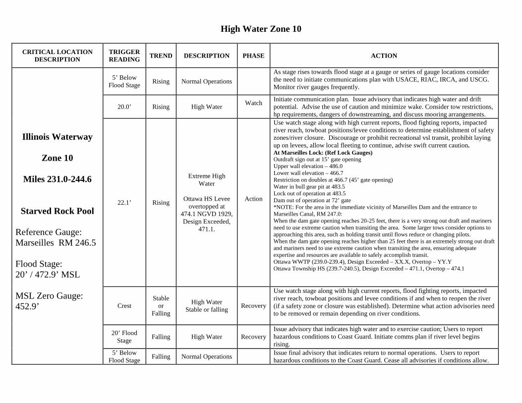
High Water Zone 10
CRITICAL LOCATION DESCRIPTION
TRIGGER READING TREND DESCRIPTION PHASE ACTION
Illinois Waterway
Zone 10
Miles 231.0-244.6
Starved Rock Pool
Reference Gauge: Marseilles RM 246.5 Flood Stage: 20’ / 472.9’ MSL MSL Zero Gauge: 452.9’
5’ Below Flood Stage Rising Normal Operations
As stage rises towards flood stage at a gauge or series of gauge locations consider the need to initiate communications plan with USACE, RIAC, IRCA, and USCG. Monitor river gauges frequently.
20.0’ Rising High Water Watch
Initiate communication plan. Issue advisory that indicates high water and drift potential. Advise the use of caution and minimize wake. Consider tow restrictions, hp requirements, dangers of downstreaming, and discuss mooring arrangements.
22.1’ Rising
Extreme High Water
Ottawa HS Levee
overtopped at 474.1 NGVD 1929, Design Exceeded,
471.1.
Action
Use watch stage along with high current reports, flood fighting reports, impacted river reach, towboat positions/levee conditions to determine establishment of safety zones/river closure. Discourage or prohibit recreational vsl transit, prohibit laying up on levees, allow local fleeting to continue, advise swift current caution. At Marseilles Lock: (Ref Lock Gauges) Outdraft sign out at 15’ gate opening Upper wall elevation – 486.0 Lower wall elevation – 466.7 Restriction on doubles at 466.7 (45’ gate opening) Water in bull gear pit at 483.5 Lock out of operation at 483.5 Dam out of operation at 72’ gate *NOTE: For the area in the immediate vicinity of Marseilles Dam and the entrance to Marseilles Canal, RM 247.0: When the dam gate opening reaches 20-25 feet, there is a very strong out draft and mariners need to use extreme caution when transiting the area. Some larger tows consider options to approaching this area, such as holding transit until flows reduce or changing pilots. When the dam gate opening reaches higher than 25 feet there is an extremely strong out draft and mariners need to use extreme caution when transiting the area, ensuring adequate expertise and resources are available to safely accomplish transit. Ottawa WWTP (239.0-239.4), Design Exceeded – XX.X, Overtop – YY.Y Ottawa Township HS (239.7-240.5), Design Exceeded – 471.1, Overtop – 474.1
Crest Stable
or Falling
High Water Stable or falling Recovery
Use watch stage along with high current reports, flood fighting reports, impacted river reach, towboat positions and levee conditions if and when to reopen the river (if a safety zone or closure was established). Determine what action advisories need to be removed or remain depending on river conditions.
20’ Flood Stage Falling High Water Recovery
Issue advisory that indicates high water and to exercise caution; Users to report hazardous conditions to Coast Guard. Initiate comms plan if river level begins rising.
5’ Below Flood Stage Falling Normal Operations Issue final advisory that indicates return to normal operations. Users to report
hazardous conditions to the Coast Guard. Cease all advisories if conditions allow.
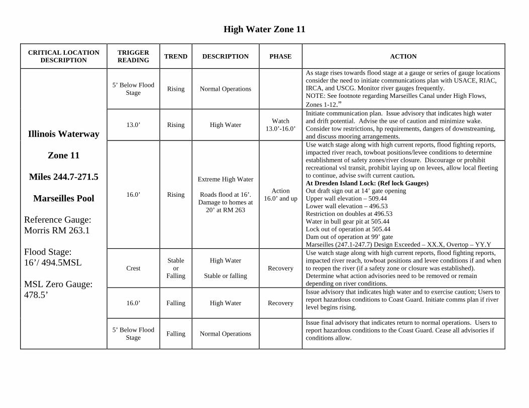
High Water Zone 11
CRITICAL LOCATION DESCRIPTION
TRIGGER READING TREND DESCRIPTION PHASE ACTION
Illinois Waterway
Zone 11
Miles 244.7-271.5
Marseilles Pool Reference Gauge: Morris RM 263.1 Flood Stage: 16’/ 494.5MSL MSL Zero Gauge: 478.5’
5’ Below Flood Stage Rising Normal Operations
As stage rises towards flood stage at a gauge or series of gauge locations consider the need to initiate communications plan with USACE, RIAC, IRCA, and USCG. Monitor river gauges frequently. NOTE: See footnote regarding Marseilles Canal under High Flows, Zones 1-12.”
13.0’ Rising High Water Watch 13.0’-16.0’
Initiate communication plan. Issue advisory that indicates high water and drift potential. Advise the use of caution and minimize wake. Consider tow restrictions, hp requirements, dangers of downstreaming, and discuss mooring arrangements.
16.0’ Rising
Extreme High Water
Roads flood at 16’. Damage to homes at
20’ at RM 263
Action 16.0’ and up
Use watch stage along with high current reports, flood fighting reports, impacted river reach, towboat positions/levee conditions to determine establishment of safety zones/river closure. Discourage or prohibit recreational vsl transit, prohibit laying up on levees, allow local fleeting to continue, advise swift current caution. At Dresden Island Lock: (Ref lock Gauges) Out draft sign out at 14’ gate opening Upper wall elevation – 509.44 Lower wall elevation – 496.53 Restriction on doubles at 496.53 Water in bull gear pit at 505.44 Lock out of operation at 505.44 Dam out of operation at 99’ gate Marseilles (247.1-247.7) Design Exceeded – XX.X, Overtop – YY.Y
Crest Stable
or Falling
High Water
Stable or falling Recovery
Use watch stage along with high current reports, flood fighting reports, impacted river reach, towboat positions and levee conditions if and when to reopen the river (if a safety zone or closure was established). Determine what action advisories need to be removed or remain depending on river conditions.
16.0’ Falling High Water Recovery
Issue advisory that indicates high water and to exercise caution; Users to report hazardous conditions to Coast Guard. Initiate comms plan if river level begins rising.
5’ Below Flood Stage Falling Normal Operations
Issue final advisory that indicates return to normal operations. Users to report hazardous conditions to the Coast Guard. Cease all advisories if conditions allow.
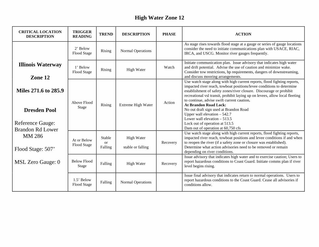
High Water Zone 12
CRITICAL LOCATION DESCRIPTION
TRIGGER READING TREND DESCRIPTION PHASE ACTION
Illinois Waterway
Zone 12
Miles 271.6 to 285.9
Dresden Pool Reference Gauge: Brandon Rd Lower MM 286 Flood Stage: 507’ MSL Zero Gauge: 0
2’ Below Flood Stage Rising Normal Operations
As stage rises towards flood stage at a gauge or series of gauge locations consider the need to initiate communications plan with USACE, RIAC, IRCA, and USCG. Monitor river gauges frequently.
1’ Below Flood Stage Rising High Water Watch
Initiate communication plan. Issue advisory that indicates high water and drift potential. Advise the use of caution and minimize wake. Consider tow restrictions, hp requirements, dangers of downstreaming, and discuss mooring arrangements.
Above Flood Stage Rising Extreme High Water Action
Use watch stage along with high current reports, flood fighting reports, impacted river reach, towboat positions/levee conditions to determine establishment of safety zones/river closure. Discourage or prohibit recreational vsl transit, prohibit laying up on levees, allow local fleeting to continue, advise swift current caution. At Brandon Road Lock: No out draft sign used at Brandon Road Upper wall elevation – 542.7 Lower wall elevation – 513.5 Lock out of operation at 513.5 Dam out of operation at 60,750 cfs
At or Below Flood Stage
Stable or
Falling
High Water
stable or falling Recovery
Use watch stage along with high current reports, flood fighting reports, impacted river reach, towboat positions and levee conditions if and when to reopen the river (if a safety zone or closure was established). Determine what action advisories need to be removed or remain depending on river conditions.
Below Flood Stage Falling High Water Recovery
Issue advisory that indicates high water and to exercise caution; Users to report hazardous conditions to Coast Guard. Initiate comms plan if river level begins rising.
1.5’ Below Flood Stage Falling Normal Operations
Issue final advisory that indicates return to normal operations. Users to report hazardous conditions to the Coast Guard. Cease all advisories if conditions allow.
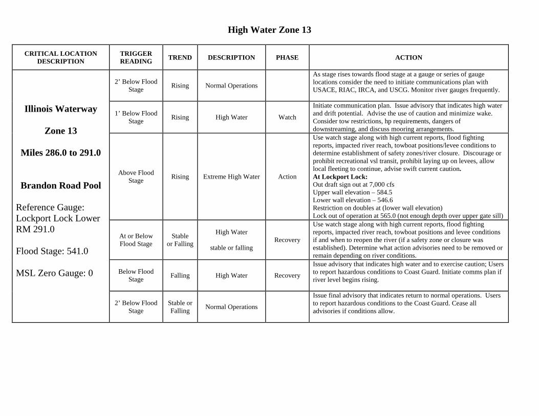
High Water Zone 13
CRITICAL LOCATION DESCRIPTION
TRIGGER READING TREND DESCRIPTION PHASE ACTION
Illinois Waterway
Zone 13
Miles 286.0 to 291.0
Brandon Road Pool
Reference Gauge: Lockport Lock Lower RM 291.0 Flood Stage: 541.0 MSL Zero Gauge: 0
2’ Below Flood Stage Rising Normal Operations
As stage rises towards flood stage at a gauge or series of gauge locations consider the need to initiate communications plan with USACE, RIAC, IRCA, and USCG. Monitor river gauges frequently.
1’ Below Flood Stage Rising High Water Watch
Initiate communication plan. Issue advisory that indicates high water and drift potential. Advise the use of caution and minimize wake. Consider tow restrictions, hp requirements, dangers of downstreaming, and discuss mooring arrangements.
Above Flood Stage Rising Extreme High Water Action
Use watch stage along with high current reports, flood fighting reports, impacted river reach, towboat positions/levee conditions to determine establishment of safety zones/river closure. Discourage or prohibit recreational vsl transit, prohibit laying up on levees, allow local fleeting to continue, advise swift current caution. At Lockport Lock: Out draft sign out at 7,000 cfs Upper wall elevation – 584.5 Lower wall elevation – 546.6 Restriction on doubles at (lower wall elevation) Lock out of operation at 565.0 (not enough depth over upper gate sill)
At or Below Flood Stage
Stable or Falling
High Water
stable or falling Recovery
Use watch stage along with high current reports, flood fighting reports, impacted river reach, towboat positions and levee conditions if and when to reopen the river (if a safety zone or closure was established). Determine what action advisories need to be removed or remain depending on river conditions.
Below Flood Stage Falling High Water Recovery
Issue advisory that indicates high water and to exercise caution; Users to report hazardous conditions to Coast Guard. Initiate comms plan if river level begins rising.
2’ Below Flood Stage
Stable or Falling Normal Operations
Issue final advisory that indicates return to normal operations. Users to report hazardous conditions to the Coast Guard. Cease all advisories if conditions allow.
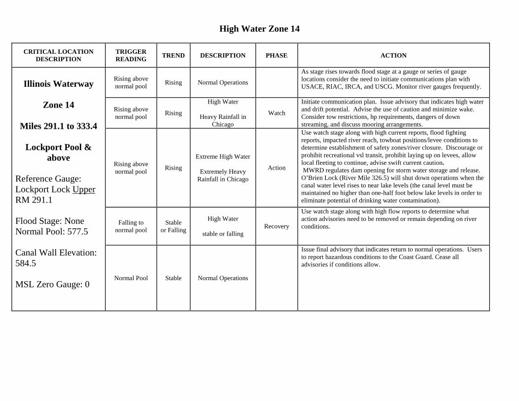
High Water Zone 14
CRITICAL LOCATION DESCRIPTION
TRIGGER READING TREND DESCRIPTION PHASE ACTION
Illinois Waterway
Zone 14
Miles 291.1 to 333.4
Lockport Pool &
above Reference Gauge: Lockport Lock Upper RM 291.1 Flood Stage: None Normal Pool: 577.5 Canal Wall Elevation: 584.5 MSL Zero Gauge: 0
Rising above normal pool Rising Normal Operations
As stage rises towards flood stage at a gauge or series of gauge locations consider the need to initiate communications plan with USACE, RIAC, IRCA, and USCG. Monitor river gauges frequently.
Rising above normal pool Rising
High Water
Heavy Rainfall in Chicago
Watch
Initiate communication plan. Issue advisory that indicates high water and drift potential. Advise the use of caution and minimize wake. Consider tow restrictions, hp requirements, dangers of down streaming, and discuss mooring arrangements.
Rising above normal pool Rising
Extreme High Water
Extremely Heavy Rainfall in Chicago
Action
Use watch stage along with high current reports, flood fighting reports, impacted river reach, towboat positions/levee conditions to determine establishment of safety zones/river closure. Discourage or prohibit recreational vsl transit, prohibit laying up on levees, allow local fleeting to continue, advise swift current caution. MWRD regulates dam opening for storm water storage and release. O’Brien Lock (River Mile 326.5) will shut down operations when the canal water level rises to near lake levels (the canal level must be maintained no higher than one-half foot below lake levels in order to eliminate potential of drinking water contamination).
Falling to normal pool
Stable or Falling
High Water
stable or falling Recovery
Use watch stage along with high flow reports to determine what action advisories need to be removed or remain depending on river conditions.
Normal Pool Stable Normal Operations
Issue final advisory that indicates return to normal operations. Users to report hazardous conditions to the Coast Guard. Cease all advisories if conditions allow.
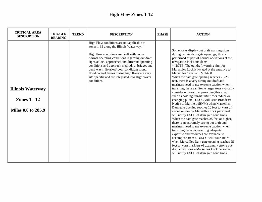
High Flow Zones 1-12
CRITICAL AREA
DESCRIPTION TRIGGER READING
TREND DESCRIPTION PHASE ACTION
Illinois Waterway
Zones 1 - 12
Miles 0.0 to 285.9
High Flow conditions are not applicable to zones 1-12 along the Illinois Waterway. High flow conditions are dealt with under normal operating conditions regarding out draft signs at lock approaches and different operating conditions and approach methods at bridges and bend ways. Erosion/scour conditions along flood control levees during high flows are very site specific and are integrated into High Water conditions.
Some locks display out draft warning signs during certain dam gate openings; this is performed as part of normal operations at the navigation locks and dams * NOTE: The out draft warning sign for Marseilles Lock is located at the entrance to Marseilles Canal at RM 247.0. When the dam gate opening reaches 20-25 feet, there is a very strong out draft and mariners need to use extreme caution when transiting the area. Some larger tows typically consider options to approaching this area, such as holding transit until flows reduce or changing pilots. USCG will issue Broadcast Notice to Mariners (BNM) when Marseilles Dam gate opening reaches 20 feet to warn of strong outdraft – Marseilles Lock personnel will notify USCG of dam gate conditions. When the dam gate reaches 25 feet or higher, there is an extremely strong out draft and mariners need to use extreme caution when transiting the area, ensuring adequate expertise and resources are available to accomplish transit. USCG will issue BNM when Marseilles Dam gate opening reaches 25 feet to warn mariners of extremely strong out draft conditions – Marseilles Lock personnel will notify USCG of dam gate conditions.
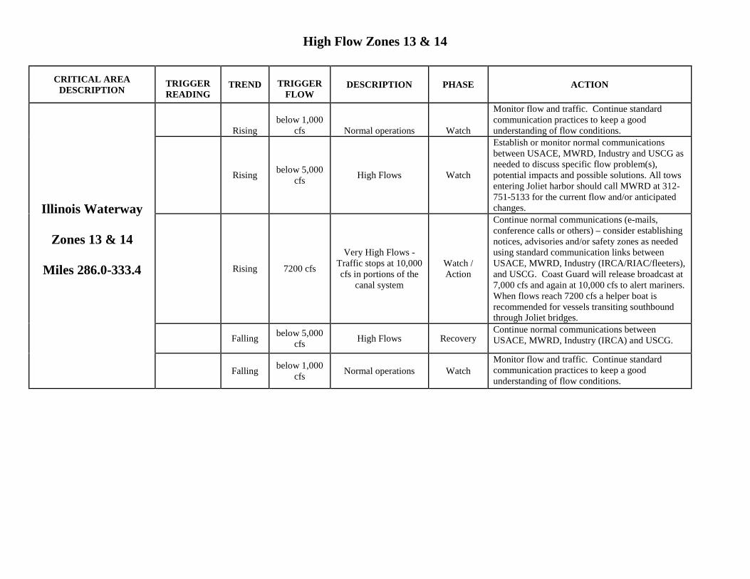
High Flow Zones 13 & 14
CRITICAL AREA DESCRIPTION
TRIGGER READING
TREND TRIGGER FLOW
DESCRIPTION PHASE ACTION
Illinois Waterway
Zones 13 & 14
Miles 286.0-333.4
Rising below 1,000
cfs Normal operations Watch
Monitor flow and traffic. Continue standard communication practices to keep a good understanding of flow conditions.
Rising below 5,000 cfs High Flows Watch
Establish or monitor normal communications between USACE, MWRD, Industry and USCG as needed to discuss specific flow problem(s), potential impacts and possible solutions. All tows entering Joliet harbor should call MWRD at 312-751-5133 for the current flow and/or anticipated changes.
Rising 7200 cfs
Very High Flows - Traffic stops at 10,000 cfs in portions of the
canal system
Watch / Action
Continue normal communications (e-mails, conference calls or others) – consider establishing notices, advisories and/or safety zones as needed using standard communication links between USACE, MWRD, Industry (IRCA/RIAC/fleeters), and USCG. Coast Guard will release broadcast at 7,000 cfs and again at 10,000 cfs to alert mariners. When flows reach 7200 cfs a helper boat is recommended for vessels transiting southbound through Joliet bridges.
Falling below 5,000 cfs High Flows Recovery
Continue normal communications between USACE, MWRD, Industry (IRCA) and USCG.
Falling below 1,000 cfs Normal operations Watch
Monitor flow and traffic. Continue standard communication practices to keep a good understanding of flow conditions.
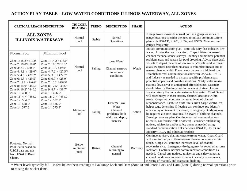
ACTION PLAN TABLE – LOW WATER CONDITIONS ILLINOIS WATERWAY, ALL ZONES
CRITICAL REACH DESCRIPTION TRIGGER READING TREND DESCRIPTION PHASE ACTION
ALL ZONES ILLINOIS WATERWAY
Normal pool Stable Normal
Operations
If stage lowers towards normal pool at a gauge or series of gauge locations consider the need to initiate communications plan with USACE, RIAC, IRCA, and USCG. Monitor river gauges frequently.
Normal pool Falling
Low Water
Channel narrows in various conditions
Watch
Initiate communication plan. Issue advisory that indicates low water. Advise the use of caution. Corps initiates increased channel reconnaissance surveys. Identify and monitor potential problem areas and reason for pool dropping. Advise deep draft vessels to depart the area of low water. Vessels need to transit at a slow speed near fleeting areas to minimize impact due to narrow channel width. Place heavy barges in middle of tow. Establish normal communications between USACE, USCG and Industry as needed to discuss specific problem areas, potential impacts and possible solutions. Notify water intake stations down river in anticipated affected zones. Mariners should identify fleeting areas in the event of river closure.
Normal Pool Zone 1: 15.2’/ 419.0’ Zone 2: 19.0’/419.0’ Zone 3: 2.0’/ 420.0’ Zone 4: 9.1’ / 429.0’* Zone 5: 4.8’ / 429.2’ Zone 6: 1.5’ / 429.5’ Zone 7: 11.6’ / 440.0* Zone 8: 14.0’ / 440.0’ Zone 9: 10.2’ / 440.2’ Zone 10: 458.5’ Zone 11: 4.7’ / 483.2’ Zone 12: 504.5’ Zone 13: 538.5’ Zone 14: 577.5 Footnote: Normal Pool levels based on USGS data and not from USACE River Charts.
Minimum Pool Zone 1: 14.2’/ 418.0’ Zone 2: 18.1’/418.1’ Zone 3: 1.0’/ 419.0’ Zone 4: 7.6’ / 427.5’* Zone 5: 3.3’ / 427.7’ Zone 6: 0.0’ / 428.0’ Zone 7: 10.0’ / 438.5* Zone 8: 12.5’ / 438.5’ Zone 9: 8.7’ / 438.7’ Zone 10: 456.5’ Zone 11: 2.7’ / 481.2’ Zone 12: 502.5’ Zone 13: 536.5’ Zone 14: 575.5’ Minimum
Pool Falling
Extreme Low Water
Channel problems, both
width and depth, increase
Action
Issue advisory that indicates extreme low water. Coast Guard will reset buoys in those narrow channel locations within reach. Corps will continue increased level of channel reconnaissance. Establish draft limits, limit barge widths, req. helper tugs, determine if fleeting can continue, pre-identify areas to lay up in event of closure, Emergency Dredging may be required at some locations. Be aware of shifting channels. Develop recovery plan Continue normal communications (e-mails, conference calls or others) – consider establishing notices, advisories and/or safety zones as needed using standard communication links between USACE, USCG and Industry (IRCA and others as needed).
Below minimum
pool Rising
Channel
returning to normal
Recovery
Continue advisory that indicates extreme water. Coast Guard will monitor buoys in those narrow channel locations within reach. Corps will continue increased level of channel reconnaissance. Emergency dredging may be required at some locations. Continue normal communications conditions as needed. Cancel any notices, advisories and safety zones as channel conditions improve. Conduct casualty assessments, clearing of channel, and assess rail bedding.
* Water levels typically fall 1 ½ feet below these readings at LaGrange Lock and Dam (Zone 4) and Peoria Lock and Dam (Zone 7) during normal operations prior to raising the wicket dams.
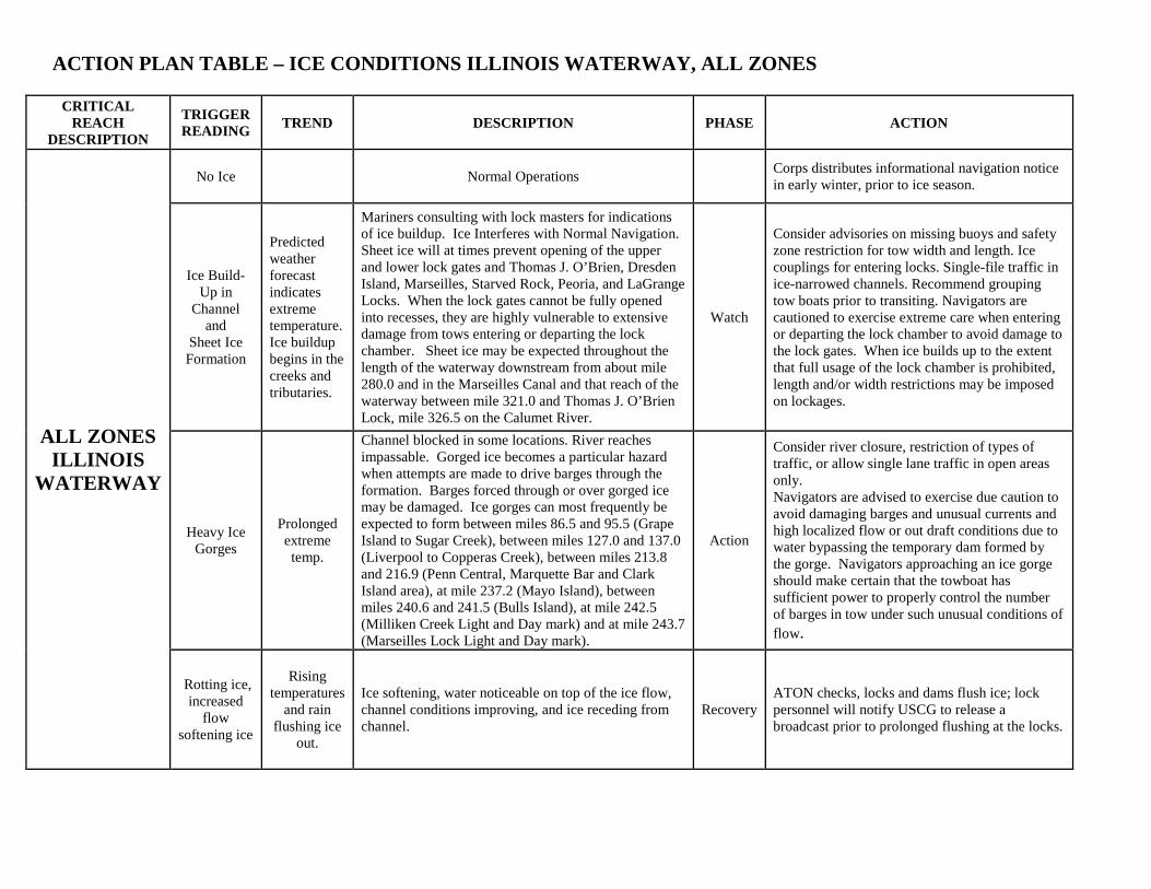
ACTION PLAN TABLE – ICE CONDITIONS ILLINOIS WATERWAY, ALL ZONES
CRITICAL REACH
DESCRIPTION
TRIGGER READING TREND DESCRIPTION PHASE ACTION
ALL ZONES ILLINOIS
WATERWAY
No Ice Normal Operations Corps distributes informational navigation notice in early winter, prior to ice season.
Ice Build-Up in
Channel and
Sheet Ice Formation
Predicted weather forecast indicates extreme temperature. Ice buildup begins in the creeks and tributaries.
Mariners consulting with lock masters for indications of ice buildup. Ice Interferes with Normal Navigation. Sheet ice will at times prevent opening of the upper and lower lock gates and Thomas J. O’Brien, Dresden Island, Marseilles, Starved Rock, Peoria, and LaGrange Locks. When the lock gates cannot be fully opened into recesses, they are highly vulnerable to extensive damage from tows entering or departing the lock chamber. Sheet ice may be expected throughout the length of the waterway downstream from about mile 280.0 and in the Marseilles Canal and that reach of the waterway between mile 321.0 and Thomas J. O’Brien Lock, mile 326.5 on the Calumet River.
Watch
Consider advisories on missing buoys and safety zone restriction for tow width and length. Ice couplings for entering locks. Single-file traffic in ice-narrowed channels. Recommend grouping tow boats prior to transiting. Navigators are cautioned to exercise extreme care when entering or departing the lock chamber to avoid damage to the lock gates. When ice builds up to the extent that full usage of the lock chamber is prohibited, length and/or width restrictions may be imposed on lockages.
Heavy Ice Gorges
Prolonged extreme temp.
Channel blocked in some locations. River reaches impassable. Gorged ice becomes a particular hazard when attempts are made to drive barges through the formation. Barges forced through or over gorged ice may be damaged. Ice gorges can most frequently be expected to form between miles 86.5 and 95.5 (Grape Island to Sugar Creek), between miles 127.0 and 137.0 (Liverpool to Copperas Creek), between miles 213.8 and 216.9 (Penn Central, Marquette Bar and Clark Island area), at mile 237.2 (Mayo Island), between miles 240.6 and 241.5 (Bulls Island), at mile 242.5 (Milliken Creek Light and Day mark) and at mile 243.7 (Marseilles Lock Light and Day mark).
Action
Consider river closure, restriction of types of traffic, or allow single lane traffic in open areas only. Navigators are advised to exercise due caution to avoid damaging barges and unusual currents and high localized flow or out draft conditions due to water bypassing the temporary dam formed by the gorge. Navigators approaching an ice gorge should make certain that the towboat has sufficient power to properly control the number of barges in tow under such unusual conditions of flow.
Rotting ice, increased
flow softening ice
Rising temperatures
and rain flushing ice
out.
Ice softening, water noticeable on top of the ice flow, channel conditions improving, and ice receding from channel.
Recovery ATON checks, locks and dams flush ice; lock personnel will notify USCG to release a broadcast prior to prolonged flushing at the locks.
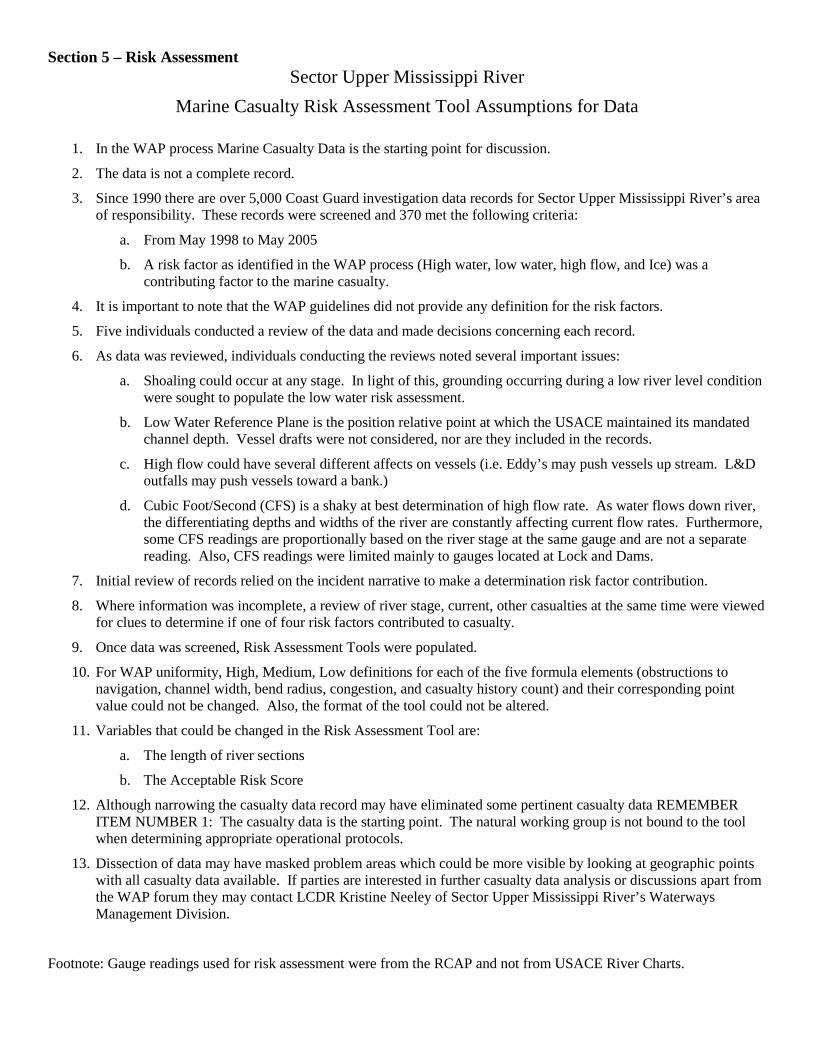
Section 5 – Risk Assessment Sector Upper Mississippi River
Marine Casualty Risk Assessment Tool Assumptions for Data
1. In the WAP process Marine Casualty Data is the starting point for discussion.
2. The data is not a complete record.
3. Since 1990 there are over 5,000 Coast Guard investigation data records for Sector Upper Mississippi River’s area of responsibility. These records were screened and 370 met the following criteria:
a. From May 1998 to May 2005
b. A risk factor as identified in the WAP process (High water, low water, high flow, and Ice) was a contributing factor to the marine casualty.
4. It is important to note that the WAP guidelines did not provide any definition for the risk factors.
5. Five individuals conducted a review of the data and made decisions concerning each record.
6. As data was reviewed, individuals conducting the reviews noted several important issues:
a. Shoaling could occur at any stage. In light of this, grounding occurring during a low river level condition were sought to populate the low water risk assessment.
b. Low Water Reference Plane is the position relative point at which the USACE maintained its mandated channel depth. Vessel drafts were not considered, nor are they included in the records.
c. High flow could have several different affects on vessels (i.e. Eddy’s may push vessels up stream. L&D outfalls may push vessels toward a bank.)
d. Cubic Foot/Second (CFS) is a shaky at best determination of high flow rate. As water flows down river, the differentiating depths and widths of the river are constantly affecting current flow rates. Furthermore, some CFS readings are proportionally based on the river stage at the same gauge and are not a separate reading. Also, CFS readings were limited mainly to gauges located at Lock and Dams.
7. Initial review of records relied on the incident narrative to make a determination risk factor contribution.
8. Where information was incomplete, a review of river stage, current, other casualties at the same time were viewed for clues to determine if one of four risk factors contributed to casualty.
9. Once data was screened, Risk Assessment Tools were populated.
10. For WAP uniformity, High, Medium, Low definitions for each of the five formula elements (obstructions to navigation, channel width, bend radius, congestion, and casualty history count) and their corresponding point value could not be changed. Also, the format of the tool could not be altered.
11. Variables that could be changed in the Risk Assessment Tool are:
a. The length of river sections
b. The Acceptable Risk Score
12. Although narrowing the casualty data record may have eliminated some pertinent casualty data REMEMBER ITEM NUMBER 1: The casualty data is the starting point. The natural working group is not bound to the tool when determining appropriate operational protocols.
13. Dissection of data may have masked problem areas which could be more visible by looking at geographic points with all casualty data available. If parties are interested in further casualty data analysis or discussions apart from the WAP forum they may contact LCDR Kristine Neeley of Sector Upper Mississippi River’s Waterways Management Division.
Footnote: Gauge readings used for risk assessment were from the RCAP and not from USACE River Charts.
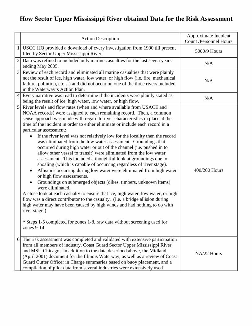
How Sector Upper Mississippi River obtained Data for the Risk Assessment
Action Description Approximate Incident Count /Personnel Hours
1 USCG HQ provided a download of every investigation from 1990 till present filed by Sector Upper Mississippi River. 5000/9 Hours
2 Data was refined to included only marine casualties for the last seven years ending May 2005. N/A
3 Review of each record and eliminated all marine casualties that were plainly not the result of ice, high water, low water, or high flow (i.e. fire, mechanical failure, pollution, etc…) and did not occur on one of the three rivers included in the Waterway’s Action Plan.
N/A
4 Every narrative was read to determine if the incidents were plainly stated as being the result of ice, high water, low water, or high flow. N/A
5
River levels and flow rates (when and where available from USACE and NOAA records) were assigned to each remaining record. Then, a common sense approach was made with regard to river characteristics in place at the time of the incident in order to either eliminate or include each record in a particular assessment:
• If the river level was not relatively low for the locality then the record was eliminated from the low water assessment. Groundings that occurred during high water or out of the channel (i.e. pushed in to allow other vessel to transit) were eliminated from the low water assessment. This included a thoughtful look at groundings due to shoaling (which is capable of occurring regardless of river stage).
• Allisions occurring during low water were eliminated from high water or high flow assessments.
• Groundings on submerged objects (dikes, timbers, unknown items) were eliminated.
A close look at each casualty to ensure that ice, high water, low water, or high flow was a direct contributor to the casualty. (I.e. a bridge allision during high water may have been caused by high winds and had nothing to do with river stage.) * Steps 1-5 completed for zones 1-8, raw data without screening used for zones 9-14
400/200 Hours
6 The risk assessment was completed and validated with extensive participation from all members of industry, Coast Guard Sector Upper Mississippi River, and MSU Chicago. In addition to the data described above, the Midland (April 2001) document for the Illinois Waterway, as well as a review of Coast Guard Cutter Officer in Charge summaries based on buoy placement, and a compilation of pilot data from several industries were extensively used.
NA/22 Hours
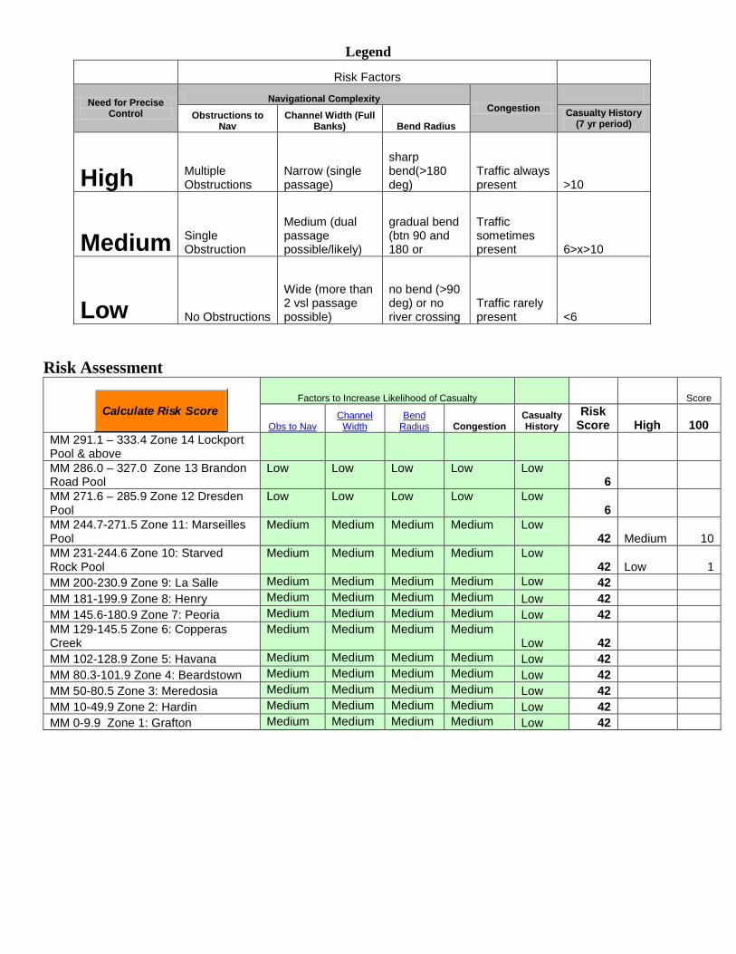
Legend
Risk Factors
Need for Precise Control
Navigational Complexity Congestion
Obstructions to Nav
Channel Width (Full Banks) Bend Radius
Casualty History (7 yr period)
High Multiple Obstructions
Narrow (single passage)
sharp bend(>180 deg)
Traffic always present >10
Medium Single Obstruction
Medium (dual passage possible/likely)
gradual bend (btn 90 and 180 or
Traffic sometimes present 6>x>10
Low No Obstructions
Wide (more than 2 vsl passage possible)
no bend (>90 deg) or no river crossing
Traffic rarely present <6
Risk Assessment
Factors to Increase Likelihood of Casualty Score
Obs to Nav Channel
Width Bend
Radius Congestion Casualty History
Risk Score High 100
MM 291.1 – 333.4 Zone 14 Lockport Pool & above
MM 286.0 – 327.0 Zone 13 Brandon Road Pool
Low Low Low Low Low 6
MM 271.6 – 285.9 Zone 12 Dresden Pool
Low Low Low Low Low 6
MM 244.7-271.5 Zone 11: Marseilles Pool
Medium Medium Medium Medium Low 42 Medium 10
MM 231-244.6 Zone 10: Starved Rock Pool
Medium Medium Medium Medium Low 42 Low 1
MM 200-230.9 Zone 9: La Salle Medium Medium Medium Medium Low 42 MM 181-199.9 Zone 8: Henry Medium Medium Medium Medium Low 42 MM 145.6-180.9 Zone 7: Peoria Medium Medium Medium Medium Low 42 MM 129-145.5 Zone 6: Copperas Creek
Medium Medium Medium Medium Low 42
MM 102-128.9 Zone 5: Havana Medium Medium Medium Medium Low 42 MM 80.3-101.9 Zone 4: Beardstown Medium Medium Medium Medium Low 42 MM 50-80.5 Zone 3: Meredosia Medium Medium Medium Medium Low 42 MM 10-49.9 Zone 2: Hardin Medium Medium Medium Medium Low 42 MM 0-9.9 Zone 1: Grafton Medium Medium Medium Medium Low 42
Calculate Risk Score