Embed Size (px)
Citation preview
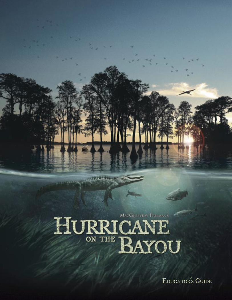
EDUCATOR’S GUIDE
Th e large format fi lm Hurricane on the Bayou is appropriate for all intermediate grades Hurricane on the Bayou is appropriate for all intermediate grades Hurricane on the Bayou(4-8). Th is Educator’s Guide will be most useful when accompanying the fi lm, but it is a valuable resource on its own. Teachers are strongly encouraged to adapt the activities in this guide to meet the specifi c needs of the grades they teach and their students.
Th is fi lm contains documentary material that may not be suitable for young children.
Hurricane on the BayouProduced and distributed by MacGillivray Freeman Films Executive produced by Audubon Nature InstituteMajor funding provided by a grant from the State of Louisianawww.hurricaneonthebayou.com
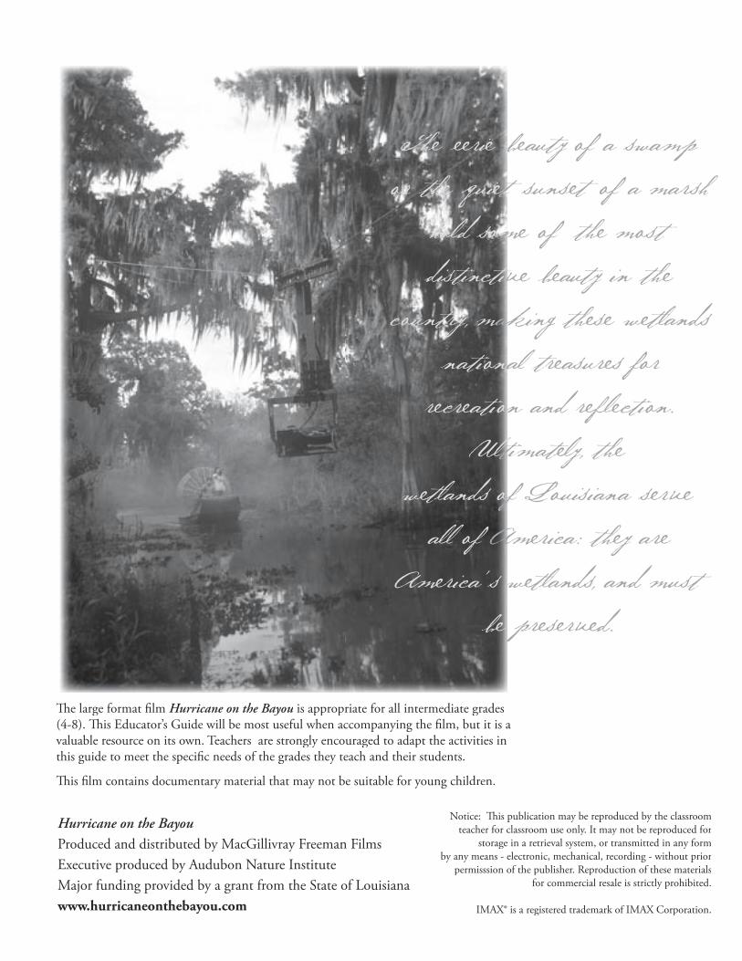
The eerie beaut y of a swamp or the quiet sunset of a marsh
hold some of the most distinctive beaut y in the
country, making these wetlands national treasures for
recreation and refl ection. Ultimatel y, the
wetlands of Louisiana serve all of America: they are
America’s wetlands, and must be preserved.
Notice: Th is publication may be reproduced by the classroom teacher for classroom use only. It may not be reproduced for
storage in a retrieval system, or transmitted in any form by any means - electronic, mechanical, recording - without prior
permisssion of the publisher. Reproduction of these materials for commercial resale is strictly prohibited.
IMAX® is a registered trademark of IMAX Corporation.
Table of ContentsIntroduction Introduction 1Hurricanes 5Wetland in a Pan 7Dress an Alligator 9Mapping the Loss 10Hurricane Tracker 11Toussaint’s Trunk 13Town Hall Meeting 14Wetland Blues 16Glossary 17Wetland Resource List 18
Dear Educator,
Th e wetlands of Louisiana are places of indescribable and haunting beauty. Th e sight of a tangerine
sunrise over honey-colored grass as a fl ock of pelicans glides over the marsh can take your breath
away. But these wetlands off er much more than sunrises. Teeming with an amazing array of plants
and animals, Louisiana’s swamps and marshes are a nursery for wildlife, a fi lter providing clean
water, and our fi rst line of defense against storms. Th ese wetlands are a critical resource and a
national treasure; preserving them is essential.
Wetlands surround and protect New Orleans – a city some call “Th e Soul of America.” Th at soul
emerges through music and the musicians who create the unique sound found nowhere else in the
world. In Hurricane on the Bayou, we are very fortunate to feature some of these talented artists,
who express their love of Louisiana’s wetlands through their own stories and music.
What would happen if “the big one” ever hit New Orleans? Th at’s the question New Orleanians
asked themselves for years, as they watched the swamps and bayous south of the city wash away.
When Hurricane Katrina, one of the worst natural disasters in the history of the United States,
fi nally struck, the wetlands that could have buff ered the city were gone – leaving New Orleans and
its residents more vulnerable than ever. Hurricane on the Bayou documents this destructive storm
and follows several musicians as they share their very personal stories of Katrina.
While parts of the fi lm focus on the devastating aftermath of Katrina, it is important to remember
that this is a fi lm of hope. Just as wetlands are a place of continual renewal and rebirth, Hurricane
on the Bayou shows all of us how people can overcome tragedy, pull themselves back up, and work
to save their homes, their culture, and the wetlands they love.
Audubon Nature Institute is very proud to present Hurricane on the Bayou, a fi lm that documents
both the frail beauty and awesome power of nature. For many years, we have educated people
about the plight of wetlands. We’ve created learning experiences for families, schools, and
community groups that speak to the need to preserve these habitats. Th is fi lm allows us to promote
an even broader awareness of this critical issue.
It is our hope that after viewing the fi lm, you and your students will recognize the importance of
wetlands to Louisiana and the rest of the United States. And we hope you will feel motivated to do
your part to help protect these magnifi cent borderlands where land and water mingle, where people
fi nd hope in rebuilding, and where alligators bellow in salute of a natural treasure that has survived
through the centuries. May it endure for the generations to come!
L. Ronald FormanL. Ronald Forman
President and CEO
Audubon Nature Institute
Mississippi River Lake Pontchartrain
City of New OrleansGround ElevationsPr
ote
ctiv
e le
vee
sa
nd
flo
od
wa
lls
Pro
tec
tive
leve
es
an
d fl
oo
dw
alls
Ge
ntil
ly R
idg
e
Dill
ard
Un
ive
rsity
UN
O
Ele
vatio
n in
Fe
et
Sea Level Sea Level
NewOrleans
12
Ele
vatio
n in
Fe
et
Ca
na
l Str
ee
t
1
2
St. L
ou
is C
ath
ed
ral
A Gumbo of CulturesAnyone who has visited the rich swamps, marshes, and bayous of southern Louisiana fi nds them teeming with fi sh, birds, alligators, and numerous species of plants and other animals. Louisiana’s unique wetlands and strategic location at the mouth of the Mississippi River have attracted people of various cultures to the area for centuries, making New Orleans a city of vivid contrasts. Its elegance, culture, and commercial richness have given the city a charm seldom matched in other cities.
Th e fi rst group of people to infl uence the area was the Native Americans. Th e Chitimacha, Choctaw, and Houma all had established cultures in this region by the time Europeans arrived. France and Spain also made contributions to the New Orleans culture. Th ese two countries served as provincial rulers of the city for a full century before it became part of the United States. Louisiana also has been infl uenced by the cultures of Africa, the West Indies, Germany, Yugoslavia, Vietnam, and the countries of Central and South America.
Probably the group of people most associated with south Louisiana is the Cajuns. Th e word “Cajun” is a shortened version of the word Acadian. Th e Acadians were originally French farmers who lived in Nova Scotia in what is now Canada. In the 1700s, the Acadians were forced out of their homeland and exiled by the British. In time, many of them settled along the bayous and prairies of south Louisiana, where they carved out a
living raising cattle, fi shing, farming, hunting, and trapping.
Th is cultural richness has made south Louisiana a celebration of life through food, art, festivals, and music. Th e blending of these great cultures has created a unique gumbo of sights and sounds, making New Orleans one of the most beloved cities in the United States.
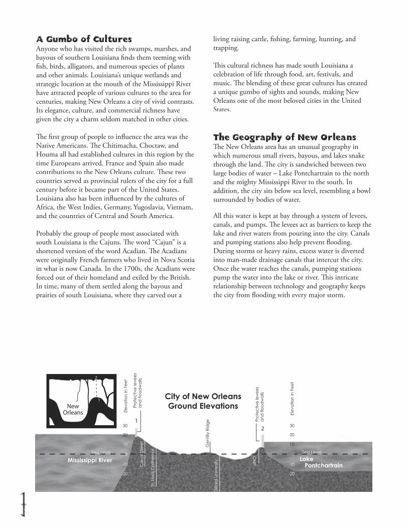
The Geography of New OrleansTh e New Orleans area has an unusual geography in which numerous small rivers, bayous, and lakes snake through the land. Th e city is sandwiched between two large bodies of water – Lake Pontchartrain to the north and the mighty Mississippi River to the south. In addition, the city sits below sea level, resembling a bowl surrounded by bodies of water.
All this water is kept at bay through a system of levees, canals, and pumps. Th e levees act as barriers to keep the lake and river waters from pouring into the city. Canals and pumping stations also help prevent fl ooding. During storms or heavy rains, excess water is diverted into man-made drainage canals that intercut the city. Once the water reaches the canals, pumping stations pump the water into the lake or river. Th is intricate relationship between technology and geography keeps the city from fl ooding with every major storm.

Mississippi River Lake Pontchartrain
City of New OrleansGround ElevationsPr
ote
ctiv
e le
vee
sa
nd
flo
od
wa
lls
Ge
ntil
ly R
idg
e
Dill
ard
Un
ive
rsity
UN
O
Ele
vatio
n in
Fe
et
Sea Level Sea Level
Ele
vatio
n in
Fe
et
St. L
ou
is C
ath
ed
ral
What Happened During Katrina?During Katrina, some of the levees failed due to tremendous pressure from the force of excess water. Because New Orleans sits below sea level, water poured into the city. Th e structures that usually keep water out of the city began trapping it within the bowl of New Orleans instead.
As mentioned in the fi lm, shipping and other man-made channels that run from the city to the Gulf of Mexico also contributed to the fl ooding that occurred during Katrina. As the hurricane pushed a powerful storm surge ahead of it, these channels acted as high-ways for the surge, pushing the water up the channels and into parts of the city.
What Are Wetlands?In the simplest sense, wetlands are wet places, a mixture of land and water combined in intricate ways to create a remarkably diverse assortment of habitats. Water is the lifeblood of wetlands and is the dominant infl uence on soil structure and the plants and animals that character-ize various wetland habitats.
Generally, we defi ne and describe wetlands in terms of the following:
• Waterlogged soil or soil covered with shallow water for at least part of the year • Special soils that are adapted to a water-logged environment • Vegetation adapted to wet conditions
Types of WetlandsTh ere are many diff erent types of wetlands, from bogs and swamps to marshes and mangroves. All wetlands can be organized into two main categories: coastal wetlands and inland wetlands. Th e most common types of wetlands found in Louisiana are swamps and marshes. In short, a marsh is a fl ooded grassland and a swamp is a fl ooded forest. Th e fl otant marshes seen in the fi lm are an example of what some marshes look like.
Below are short descriptions of these Louisiana wetland habitats.
Freshwater marshes are a type of inland wetland. Th ey are fl at, open, watery areas with very few trees. Th e soil is full of minerals, and the predominant vegetation is sedges, reeds and grasses.
Saltwater marshes are a type of coastal wetland. Th ey are typically found in the sheltered coastal areas behind barrier islands or in river estuaries (the areas at river mouths where fresh- and saltwater mingle). Plant life is dominated by various grasses.
Swamps are inland wetlands in which trees dominate the vegetation. Th e ground is usually covered by water (a few inches to a few feet) during the growing season, but may dry out in late summer.
Why Are Wetlands Important?People often think of wetlands as dark, spooky places with little or no value. Th is could not be further from the truth. Th e wetlands of Louisiana are important, not just for Louisiana, but for the rest of the United States as well.
When the river or heavy rains saturate or fl ood the wetlands, they replenish that area with freshwater and nutrients. In this way, wetlands act as a natural purifi ca-tion system by cleaning the groundwater and supplying nourishment for the abundant wildlife found there.
Wetland soil and plants gradually absorb the water
and thus act as a fi lter, cleaning the water supply. Wetland plants also keep the land from washing away: their root systems hold the ground in place and prevent soil erosion.
Th e wetlands are also a critical force in reducing the destructive power of storms and hurricanes. When storms move over open water, there is nothing to slow the wind and wave action. Th is creates a storm surge – a gigantic wall of water pushed forward by the storm’s winds. Th e vegetation of the wetlands helps minimize the storm surge. When powerful waves from a hurricane crash into the land, wetland plants act as brakes, slowing down the waves and reducing their destructive power. For every 3 miles of marsh, the storm surge of a hurricane is reduced in height by 1 foot!
Because Louisiana’s wetlands are so rich in nutrients, they are a critical rest stop for numerous species of migratory birds and a vital nursery for the young of many fi sh and other animals. Th e abundance of plants, fi sh, reptiles, mammals, amphibians, and insects speaks to the value and importance of these habitats and points to the need to restore and preserve them.
Th e wetlands of Louisiana are not only important to wildlife; they also serve commercial industries important to the rest of the nation. Th e rich environ-ment of Louisiana’s wetlands provides 30 percent of the seafood catch in the contiguous United States. Additionally, 25 percent of the nation’s oil and gas reserves pass through these wetlands on their way to the rest of the country, and 21 percent of all waterborne U.S. commerce is protected by these same wetlands. Finally, the eerie beauty of a swamp or the quiet sunset of a marsh hold some of the most distinctive beauty in the country, making these wetlands national treasures for recreation and refl ection. Ultimately, the wetlands of Louisiana serve all of America: they are America’s wetlands, and must be America’s wetlands, and must be America’spreserved.
Wetland LossHurricane on the BayouHurricane on the BayouHurr notes that 48 percent of the
lower 48 states’ coastal wetlands are in Louisiana. You could plunk the entire Everglades inside Louisiana’s wetlands and hardly notice the new real estate. Yet, despite their value to humans and wildlife, wetlands in the United States have declined throughout our history. We have lost more than 55 percent of the wetlands that were here when the fi rst Europeans arrived in the 15th century – a loss of more than 100 million acres!
Over 80% of U.S. wetland loss is in Louisiana: the equivalent of a football fi eld is lost every 30 minutes! Without intervention, Louisiana will lose between 25 and 35 square miles of wetlands each year, amounting to a projected loss of 527,000 acres by 2040. Th e causes for this loss are numerous. While many of the causes are man-made, it is important to note that several were
enacted many generations ago, when their long-term eff ects could not be foreseen.
As the fi lm points out, America’s mightiest river, the Mississippi, overfl owed its banks each spring for thousands of years. Th is periodic fl ooding fed the soils of the wetlands and helped reduce erosion caused by the waters of the Gulf of Mexico. Centuries ago, when people began to move into the region, they recognized the importance of the Mississippi River as a waterway for trade and commerce. Th ey forced the river into one route and prevented it from meandering, as it had done previously. Without periodic fl ooding from the river to replenish the wetlands with fresh water and soil, they compact and sink, or wash away.
Cypress logging also contributed to wetland loss. In the early 20th century,
The wetlands are
a critical force in
reducing the
destructive power
of storms and
hurricanes...For
every 3 miles of
marsh, the storm
surge of a hurricane
is reduced in height
by 1 foot!
Restoration Description Wetland LossProject of Project Issue Restoration Description Wetland LossProject Restoration Description Wetland Loss
numerous cypress forests were cut down to provide lumber for housing and other necessities. Th e removal of these trees weakened the soils and helped to increase erosion in freshwater swamps.
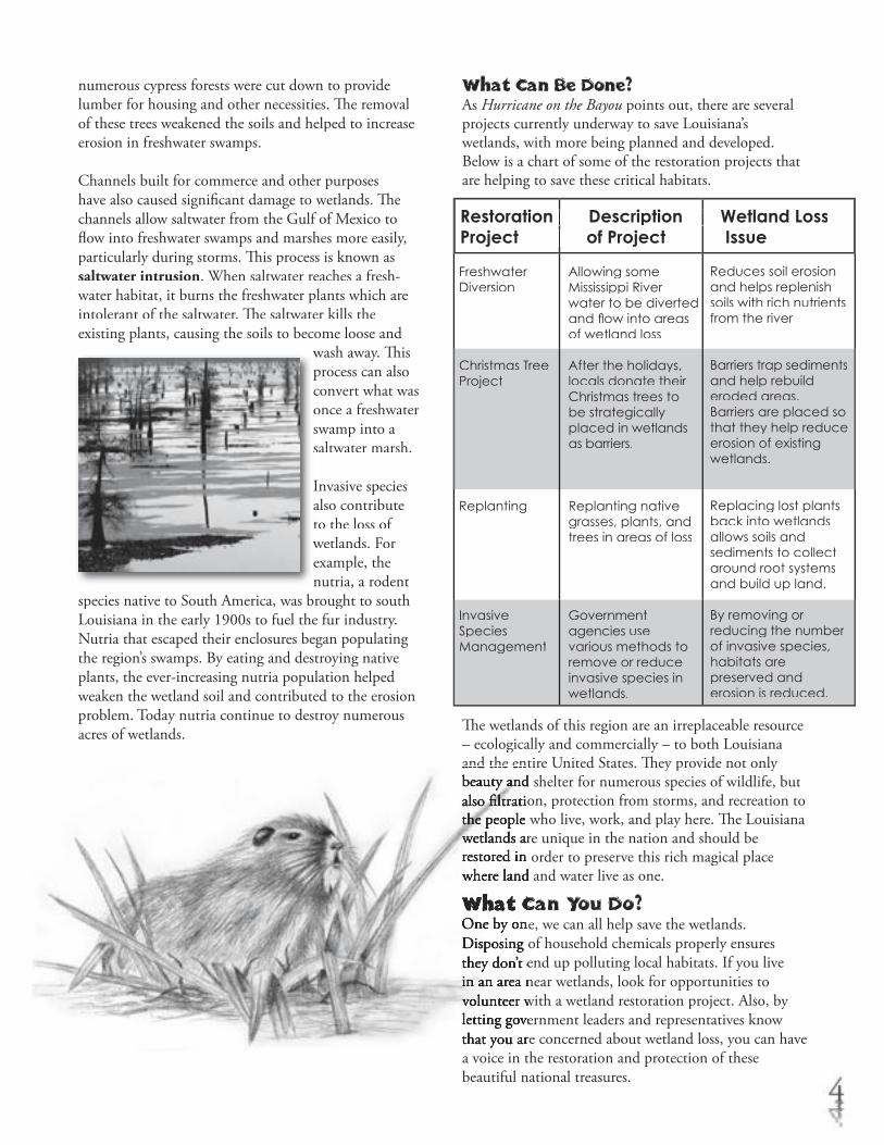
Channels built for commerce and other purposes have also caused signifi cant damage to wetlands. Th e channels allow saltwater from the Gulf of Mexico to fl ow into freshwater swamps and marshes more easily, particularly during storms. Th is process is known as saltwater intrusion. When saltwater reaches a fresh-water habitat, it burns the freshwater plants which are intolerant of the saltwater. Th e saltwater kills the existing plants, causing the soils to become loose and
wash away. Th is wash away. Th is process can also convert what was once a freshwater swamp into a saltwater marsh.
Invasive species also contribute to the loss of wetlands. For wetlands. For example, the nutria, a rodent
species native to South America, was brought to south Louisiana in the early 1900s to fuel the fur industry. Nutria that escaped their enclosures began populating the region’s swamps. By eating and destroying native plants, the ever-increasing nutria population helped weaken the wetland soil and contributed to the erosion problem. Today nutria continue to destroy numerous acres of wetlands.
What Can Be Done?As Hurricane on the Bayou points out, there are several projects currently underway to save Louisiana’s underway to save Louisiana’s underwaywetlands, with more being planned and developed. Below is a chart of some of the restoration projects that are helping to save these critical habitats.
Th e wetlands of this region are an irreplaceable resource – ecologically and commercially – to both Louisiana and the entire United States. Th ey provide not only and the entire United States. Th ey provide not only beauty and shelter for numerous species of wildlife, but beauty and shelter for numerous species of wildlife, but also fi ltration, protection from storms, and recreation to also fi ltration, protection from storms, and recreation to the people who live, work, and play here. Th e Louisiana the people who live, work, and play here. Th e Louisiana wetlands are unique in the nation and should be wetlands are unique in the nation and should be restored in order to preserve this rich magical place restored in order to preserve this rich magical place where land and water live as one.where land and water live as one.
What Can You Do?What Can You Do?One by one, we can all help save the wetlands. One by one, we can all help save the wetlands. Disposing of household chemicals properly ensures Disposing of household chemicals properly ensures they don’t end up polluting local habitats. If you live they don’t end up polluting local habitats. If you live in an area near wetlands, look for opportunities to in an area near wetlands, look for opportunities to volunteer with a wetland restoration project. Also, by volunteer with a wetland restoration project. Also, by letting government leaders and representatives know letting government leaders and representatives know that you are concerned about wetland loss, you can have that you are concerned about wetland loss, you can have a voice in the restoration and protection of these beautiful national treasures.
Freshwater Diversion
Christmas Tree Project
Replanting
Invasive Species Management
Allowing someMississippi River water to be diverted and fl ow into areas of wetland loss
After the holidays, locals donate their Christmas trees to be strategically placed in wetlands as barriers.
Replanting native grasses, plants, and trees in areas of loss
Government agencies use various methods to remove or reduce invasive species in wetlands.
Reduces soil erosion and helps replenish soils with rich nutrients from the river
Barriers trap sedimentsand help rebuild eroded areas. Barriers are placed so that they help reduce erosion of existing wetlands.
Replacing lost plants back into wetlands allows soils and sediments to collect around root systems and build up land.
By removing or reducing the number of invasive species, habitats are preserved and erosion is reduced.
HurricanesA hurricane is a severe tropical storm that forms in either the Pacifi c or Atlantic oceans. A hurricane can produce powerful winds, destructive waves, torrential rains and fl oods. In other parts of the world, these storms are called typhoons or tropical cyclones.
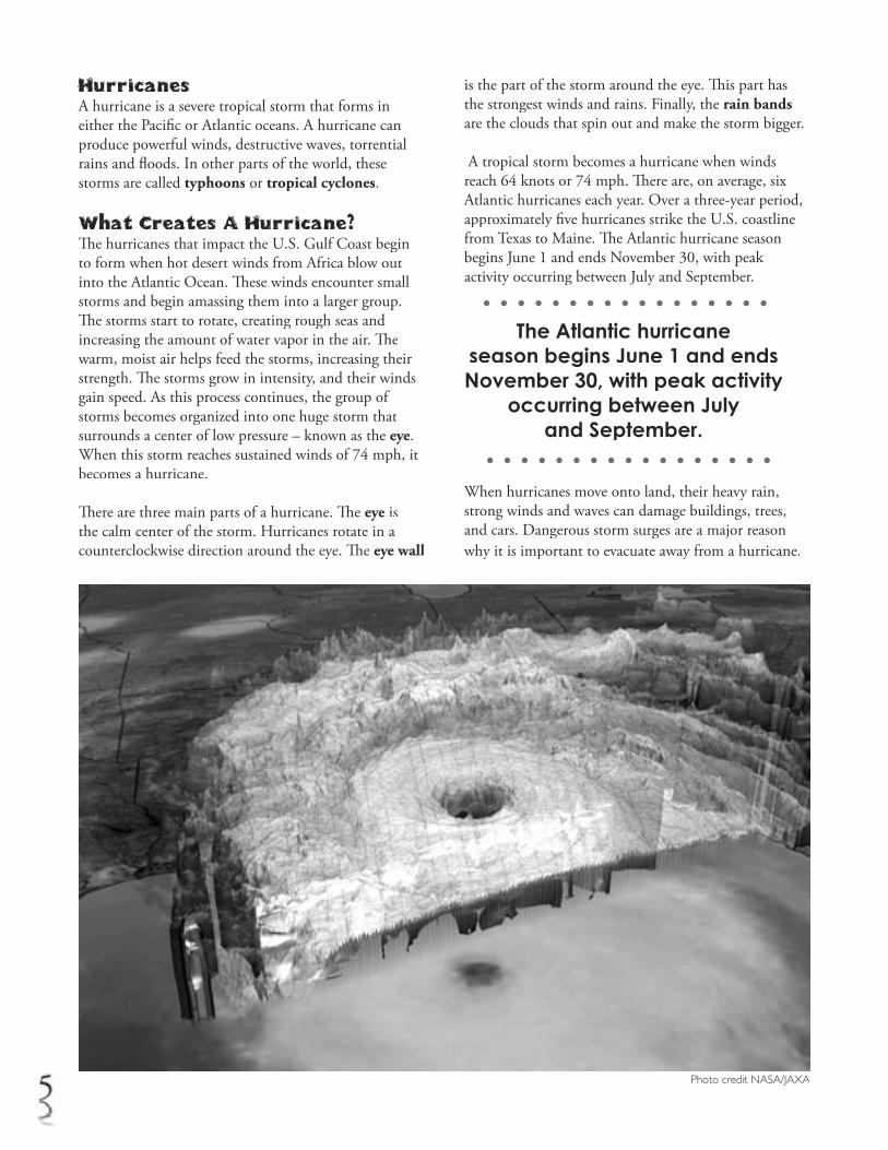
What Creates A Hurricane?Th e hurricanes that impact the U.S. Gulf Coast begin to form when hot desert winds from Africa blow out into the Atlantic Ocean. Th ese winds encounter small storms and begin amassing them into a larger group. Th e storms start to rotate, creating rough seas and increasing the amount of water vapor in the air. Th e warm, moist air helps feed the storms, increasing their strength. Th e storms grow in intensity, and their winds gain speed. As this process continues, the group of storms becomes organized into one huge storm that surrounds a center of low pressure – known as the eye. When this storm reaches sustained winds of 74 mph, it becomes a hurricane.
Th ere are three main parts of a hurricane. Th e eye is the calm center of the storm. Hurricanes rotate in a counterclockwise direction around the eye. Th e eye wall
is the part of the storm around the eye. Th is part has the strongest winds and rains. Finally, the rain bands are the clouds that spin out and make the storm bigger.
A tropical storm becomes a hurricane when winds reach 64 knots or 74 mph. Th ere are, on average, six Atlantic hurricanes each year. Over a three-year period, approximately fi ve hurricanes strike the U.S. coastline from Texas to Maine. Th e Atlantic hurricane season begins June 1 and ends November 30, with peak activity occurring between July and September.
When hurricanes move onto land, their heavy rain, strong winds and waves can damage buildings, trees, and cars. Dangerous storm surges are a major reason why it is important to evacuate away from a hurricane.
Photo credit NASA/JAXA
The Atlantic hurricaneseason begins June 1 and ends November 30, with peak activity
occurring between July and September.
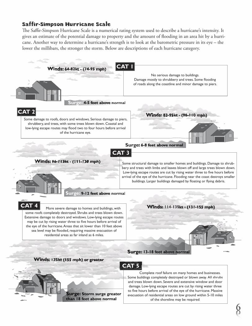
Winds: Winds: Winds: Winds: Winds: Winds: Winds: Winds: 64-82kt - (74-95 mph)64-82kt - (74-95 mph)64-82kt - (74-95 mph)64-82kt - (74-95 mph)64-82kt - (74-95 mph)64-82kt - (74-95 mph)64-82kt - (74-95 mph)64-82kt - (74-95 mph)64-82kt - (74-95 mph)64-82kt - (74-95 mph)64-82kt - (74-95 mph)64-82kt - (74-95 mph)64-82kt - (74-95 mph)64-82kt - (74-95 mph)64-82kt - (74-95 mph)64-82kt - (74-95 mph)64-82kt - (74-95 mph)64-82kt - (74-95 mph)64-82kt - (74-95 mph)64-82kt - (74-95 mph)64-82kt - (74-95 mph)64-82kt - (74-95 mph)64-82kt - (74-95 mph)64-82kt - (74-95 mph)64-82kt - (74-95 mph)64-82kt - (74-95 mph)64-82kt - (74-95 mph)64-82kt - (74-95 mph)64-82kt - (74-95 mph)64-82kt - (74-95 mph)64-82kt - (74-95 mph)64-82kt - (74-95 mph)64-82kt - (74-95 mph)64-82kt - (74-95 mph)64-82kt - (74-95 mph)64-82kt - (74-95 mph)
Surge: 4-5 feet above normal4-5 feet above normal
Winds: Winds: Winds: Winds: Winds: Winds: Winds: Winds: Winds: Winds: Winds: Winds: Winds: Winds: Winds: Winds: Winds: Winds: Winds: Winds: Winds: Winds: Winds: Winds: Winds: Winds: 83-95kt - (96-110 mph)83-95kt - (96-110 mph)83-95kt - (96-110 mph)83-95kt - (96-110 mph)83-95kt - (96-110 mph)83-95kt - (96-110 mph)83-95kt - (96-110 mph)83-95kt - (96-110 mph)83-95kt - (96-110 mph)83-95kt - (96-110 mph)83-95kt - (96-110 mph)83-95kt - (96-110 mph)83-95kt - (96-110 mph)83-95kt - (96-110 mph)83-95kt - (96-110 mph)83-95kt - (96-110 mph)83-95kt - (96-110 mph)83-95kt - (96-110 mph)83-95kt - (96-110 mph)83-95kt - (96-110 mph)83-95kt - (96-110 mph)83-95kt - (96-110 mph)83-95kt - (96-110 mph)83-95kt - (96-110 mph)83-95kt - (96-110 mph)83-95kt - (96-110 mph)83-95kt - (96-110 mph)83-95kt - (96-110 mph)83-95kt - (96-110 mph)83-95kt - (96-110 mph)83-95kt - (96-110 mph)83-95kt - (96-110 mph)83-95kt - (96-110 mph)83-95kt - (96-110 mph)83-95kt - (96-110 mph)83-95kt - (96-110 mph)83-95kt - (96-110 mph)83-95kt - (96-110 mph)83-95kt - (96-110 mph)83-95kt - (96-110 mph)83-95kt - (96-110 mph)83-95kt - (96-110 mph)83-95kt - (96-110 mph)83-95kt - (96-110 mph)
Surge: Surge: 6-8 feet above normal
Winds: Winds: Winds: Winds: Winds: 96-113kt - (111-130 mph)96-113kt - (111-130 mph)96-113kt - (111-130 mph)96-113kt - (111-130 mph)96-113kt - (111-130 mph)96-113kt - (111-130 mph)96-113kt - (111-130 mph)96-113kt - (111-130 mph)96-113kt - (111-130 mph)96-113kt - (111-130 mph)96-113kt - (111-130 mph)96-113kt - (111-130 mph)96-113kt - (111-130 mph)96-113kt - (111-130 mph)96-113kt - (111-130 mph)96-113kt - (111-130 mph)96-113kt - (111-130 mph)96-113kt - (111-130 mph)96-113kt - (111-130 mph)96-113kt - (111-130 mph)96-113kt - (111-130 mph)96-113kt - (111-130 mph)96-113kt - (111-130 mph)96-113kt - (111-130 mph)96-113kt - (111-130 mph)96-113kt - (111-130 mph)96-113kt - (111-130 mph)96-113kt - (111-130 mph)96-113kt - (111-130 mph)96-113kt - (111-130 mph)96-113kt - (111-130 mph)96-113kt - (111-130 mph)96-113kt - (111-130 mph)96-113kt - (111-130 mph)96-113kt - (111-130 mph)96-113kt - (111-130 mph)96-113kt - (111-130 mph)96-113kt - (111-130 mph)96-113kt - (111-130 mph)96-113kt - (111-130 mph)96-113kt - (111-130 mph)96-113kt - (111-130 mph)96-113kt - (111-130 mph)96-113kt - (111-130 mph)96-113kt - (111-130 mph)96-113kt - (111-130 mph)96-113kt - (111-130 mph)96-113kt - (111-130 mph)96-113kt - (111-130 mph)96-113kt - (111-130 mph)96-113kt - (111-130 mph)96-113kt - (111-130 mph)96-113kt - (111-130 mph)96-113kt - (111-130 mph)96-113kt - (111-130 mph)96-113kt - (111-130 mph)96-113kt - (111-130 mph)96-113kt - (111-130 mph)96-113kt - (111-130 mph)96-113kt - (111-130 mph)96-113kt - (111-130 mph)96-113kt - (111-130 mph)96-113kt - (111-130 mph)96-113kt - (111-130 mph)96-113kt - (111-130 mph)96-113kt - (111-130 mph)96-113kt - (111-130 mph)96-113kt - (111-130 mph)96-113kt - (111-130 mph)96-113kt - (111-130 mph)96-113kt - (111-130 mph)96-113kt - (111-130 mph)96-113kt - (111-130 mph)96-113kt - (111-130 mph)96-113kt - (111-130 mph)96-113kt - (111-130 mph)96-113kt - (111-130 mph)96-113kt - (111-130 mph)96-113kt - (111-130 mph)96-113kt - (111-130 mph)96-113kt - (111-130 mph)96-113kt - (111-130 mph)96-113kt - (111-130 mph)96-113kt - (111-130 mph)96-113kt - (111-130 mph)96-113kt - (111-130 mph)96-113kt - (111-130 mph)96-113kt - (111-130 mph)96-113kt - (111-130 mph)96-113kt - (111-130 mph)96-113kt - (111-130 mph)96-113kt - (111-130 mph)96-113kt - (111-130 mph)96-113kt - (111-130 mph)96-113kt - (111-130 mph)96-113kt - (111-130 mph)96-113kt - (111-130 mph)96-113kt - (111-130 mph)96-113kt - (111-130 mph)96-113kt - (111-130 mph)96-113kt - (111-130 mph)96-113kt - (111-130 mph)96-113kt - (111-130 mph)96-113kt - (111-130 mph)96-113kt - (111-130 mph)96-113kt - (111-130 mph)96-113kt - (111-130 mph)96-113kt - (111-130 mph)96-113kt - (111-130 mph)96-113kt - (111-130 mph)96-113kt - (111-130 mph)
Surge: 9-12 feet above normal9-12 feet above normal
Winds: Winds: Winds: Winds: Winds: Winds: Winds: Winds: Winds: Winds: Winds: Winds: Winds: Winds: Winds: Winds: Winds: Winds: Winds: Winds: Winds: Winds: Winds: Winds: Winds: Winds: Winds: Winds: Winds: Winds: Winds: Winds: Winds: Winds: Winds: Winds: Winds: Winds: Winds: Winds: Winds: Winds: Winds: Winds: 114-135kt - (131-155 mph)114-135kt - (131-155 mph)114-135kt - (131-155 mph)114-135kt - (131-155 mph)114-135kt - (131-155 mph)114-135kt - (131-155 mph)114-135kt - (131-155 mph)114-135kt - (131-155 mph)114-135kt - (131-155 mph)114-135kt - (131-155 mph)114-135kt - (131-155 mph)114-135kt - (131-155 mph)114-135kt - (131-155 mph)114-135kt - (131-155 mph)114-135kt - (131-155 mph)114-135kt - (131-155 mph)114-135kt - (131-155 mph)114-135kt - (131-155 mph)114-135kt - (131-155 mph)114-135kt - (131-155 mph)114-135kt - (131-155 mph)114-135kt - (131-155 mph)114-135kt - (131-155 mph)114-135kt - (131-155 mph)114-135kt - (131-155 mph)114-135kt - (131-155 mph)114-135kt - (131-155 mph)114-135kt - (131-155 mph)114-135kt - (131-155 mph)114-135kt - (131-155 mph)114-135kt - (131-155 mph)114-135kt - (131-155 mph)114-135kt - (131-155 mph)114-135kt - (131-155 mph)114-135kt - (131-155 mph)114-135kt - (131-155 mph)114-135kt - (131-155 mph)114-135kt - (131-155 mph)114-135kt - (131-155 mph)114-135kt - (131-155 mph)114-135kt - (131-155 mph)114-135kt - (131-155 mph)114-135kt - (131-155 mph)114-135kt - (131-155 mph)114-135kt - (131-155 mph)114-135kt - (131-155 mph)114-135kt - (131-155 mph)114-135kt - (131-155 mph)114-135kt - (131-155 mph)114-135kt - (131-155 mph)114-135kt - (131-155 mph)114-135kt - (131-155 mph)114-135kt - (131-155 mph)114-135kt - (131-155 mph)114-135kt - (131-155 mph)114-135kt - (131-155 mph)114-135kt - (131-155 mph)114-135kt - (131-155 mph)114-135kt - (131-155 mph)114-135kt - (131-155 mph)114-135kt - (131-155 mph)114-135kt - (131-155 mph)114-135kt - (131-155 mph)114-135kt - (131-155 mph)114-135kt - (131-155 mph)114-135kt - (131-155 mph)114-135kt - (131-155 mph)114-135kt - (131-155 mph)114-135kt - (131-155 mph)114-135kt - (131-155 mph)114-135kt - (131-155 mph)114-135kt - (131-155 mph)114-135kt - (131-155 mph)114-135kt - (131-155 mph)114-135kt - (131-155 mph)114-135kt - (131-155 mph)114-135kt - (131-155 mph)114-135kt - (131-155 mph)114-135kt - (131-155 mph)114-135kt - (131-155 mph)114-135kt - (131-155 mph)114-135kt - (131-155 mph)114-135kt - (131-155 mph)114-135kt - (131-155 mph)114-135kt - (131-155 mph)114-135kt - (131-155 mph)114-135kt - (131-155 mph)
Winds: Winds: Winds: Winds: Winds: Winds: Winds: Winds: Winds: Winds: Winds: Winds: Winds: Winds: Winds: Winds: Winds: Winds: Winds: Winds: Winds: Winds: Winds: Winds: Winds: Winds: Winds: Winds: Winds: Winds: Winds: Winds: Winds: Winds: Winds: Winds: Winds: Winds: Winds: Winds: Winds: Winds: Winds: Winds: Winds: Winds: Winds: Winds: Winds: Winds: Winds: Winds: Winds: Winds: Winds: Winds: Winds: Winds: Winds: Winds: Winds: Winds: Winds: Winds: Winds: Winds: Winds: Winds: Winds: Winds: Winds: Winds: Winds: Winds: Winds: Winds: Winds: Winds: Winds: Winds: Winds: Winds: Winds: Winds: Winds: Winds: Winds: Winds: Winds: Winds: Winds: Winds: Winds: 1111111111135kt (155 mph) or greater35kt (155 mph) or greater35kt (155 mph) or greater35kt (155 mph) or greater35kt (155 mph) or greater35kt (155 mph) or greater35kt (155 mph) or greater35kt (155 mph) or greater35kt (155 mph) or greater35kt (155 mph) or greater35kt (155 mph) or greater35kt (155 mph) or greater35kt (155 mph) or greater35kt (155 mph) or greater35kt (155 mph) or greater35kt (155 mph) or greater35kt (155 mph) or greater35kt (155 mph) or greater35kt (155 mph) or greater35kt (155 mph) or greater35kt (155 mph) or greater35kt (155 mph) or greater35kt (155 mph) or greater35kt (155 mph) or greater35kt (155 mph) or greater35kt (155 mph) or greater35kt (155 mph) or greater35kt (155 mph) or greater35kt (155 mph) or greater35kt (155 mph) or greater35kt (155 mph) or greater35kt (155 mph) or greater35kt (155 mph) or greater35kt (155 mph) or greater35kt (155 mph) or greater35kt (155 mph) or greater35kt (155 mph) or greater35kt (155 mph) or greater35kt (155 mph) or greater35kt (155 mph) or greater35kt (155 mph) or greater35kt (155 mph) or greater35kt (155 mph) or greater35kt (155 mph) or greater35kt (155 mph) or greater35kt (155 mph) or greater35kt (155 mph) or greater35kt (155 mph) or greater35kt (155 mph) or greater35kt (155 mph) or greater35kt (155 mph) or greater35kt (155 mph) or greater35kt (155 mph) or greater35kt (155 mph) or greater35kt (155 mph) or greater35kt (155 mph) or greater35kt (155 mph) or greater35kt (155 mph) or greater35kt (155 mph) or greater35kt (155 mph) or greater35kt (155 mph) or greater35kt (155 mph) or greater35kt (155 mph) or greater35kt (155 mph) or greater35kt (155 mph) or greater35kt (155 mph) or greater35kt (155 mph) or greater35kt (155 mph) or greater35kt (155 mph) or greater35kt (155 mph) or greater35kt (155 mph) or greater35kt (155 mph) or greater35kt (155 mph) or greater35kt (155 mph) or greater35kt (155 mph) or greater35kt (155 mph) or greater35kt (155 mph) or greater35kt (155 mph) or greater35kt (155 mph) or greater35kt (155 mph) or greater35kt (155 mph) or greater35kt (155 mph) or greater35kt (155 mph) or greater35kt (155 mph) or greater35kt (155 mph) or greater35kt (155 mph) or greater35kt (155 mph) or greater35kt (155 mph) or greater35kt (155 mph) or greater35kt (155 mph) or greater35kt (155 mph) or greater35kt (155 mph) or greater35kt (155 mph) or greater35kt (155 mph) or greater35kt (155 mph) or greater35kt (155 mph) or greater35kt (155 mph) or greater35kt (155 mph) or greater35kt (155 mph) or greater35kt (155 mph) or greater35kt (155 mph) or greater35kt (155 mph) or greater35kt (155 mph) or greater35kt (155 mph) or greater35kt (155 mph) or greater35kt (155 mph) or greater35kt (155 mph) or greater35kt (155 mph) or greater35kt (155 mph) or greater35kt (155 mph) or greater35kt (155 mph) or greater35kt (155 mph) or greater35kt (155 mph) or greater35kt (155 mph) or greater35kt (155 mph) or greater35kt (155 mph) or greater35kt (155 mph) or greater35kt (155 mph) or greater35kt (155 mph) or greater35kt (155 mph) or greater35kt (155 mph) or greater35kt (155 mph) or greater35kt (155 mph) or greater35kt (155 mph) or greater35kt (155 mph) or greater35kt (155 mph) or greater35kt (155 mph) or greater35kt (155 mph) or greater35kt (155 mph) or greater35kt (155 mph) or greater35kt (155 mph) or greater35kt (155 mph) or greater35kt (155 mph) or greater35kt (155 mph) or greater35kt (155 mph) or greater35kt (155 mph) or greater35kt (155 mph) or greater35kt (155 mph) or greater35kt (155 mph) or greater35kt (155 mph) or greater35kt (155 mph) or greater35kt (155 mph) or greater35kt (155 mph) or greater35kt (155 mph) or greater35kt (155 mph) or greater35kt (155 mph) or greater35kt (155 mph) or greater35kt (155 mph) or greater35kt (155 mph) or greater35kt (155 mph) or greater35kt (155 mph) or greater35kt (155 mph) or greater35kt (155 mph) or greater35kt (155 mph) or greater35kt (155 mph) or greater35kt (155 mph) or greater35kt (155 mph) or greater35kt (155 mph) or greater35kt (155 mph) or greater35kt (155 mph) or greater35kt (155 mph) or greater35kt (155 mph) or greater35kt (155 mph) or greater35kt (155 mph) or greater35kt (155 mph) or greater35kt (155 mph) or greater35kt (155 mph) or greater35kt (155 mph) or greater35kt (155 mph) or greater35kt (155 mph) or greater35kt (155 mph) or greater35kt (155 mph) or greater35kt (155 mph) or greater35kt (155 mph) or greater35kt (155 mph) or greater35kt (155 mph) or greater35kt (155 mph) or greater35kt (155 mph) or greater35kt (155 mph) or greater35kt (155 mph) or greater35kt (155 mph) or greater35kt (155 mph) or greater35kt (155 mph) or greater35kt (155 mph) or greater35kt (155 mph) or greater35kt (155 mph) or greater35kt (155 mph) or greater35kt (155 mph) or greater35kt (155 mph) or greater35kt (155 mph) or greater35kt (155 mph) or greater35kt (155 mph) or greater35kt (155 mph) or greater35kt (155 mph) or greater35kt (155 mph) or greater35kt (155 mph) or greater35kt (155 mph) or greater35kt (155 mph) or greater35kt (155 mph) or greater35kt (155 mph) or greater35kt (155 mph) or greater35kt (155 mph) or greater35kt (155 mph) or greater35kt (155 mph) or greater35kt (155 mph) or greater35kt (155 mph) or greater35kt (155 mph) or greater35kt (155 mph) or greater35kt (155 mph) or greater35kt (155 mph) or greater35kt (155 mph) or greater35kt (155 mph) or greater35kt (155 mph) or greater35kt (155 mph) or greater35kt (155 mph) or greater35kt (155 mph) or greater35kt (155 mph) or greater35kt (155 mph) or greater35kt (155 mph) or greater35kt (155 mph) or greater35kt (155 mph) or greater35kt (155 mph) or greater35kt (155 mph) or greater35kt (155 mph) or greater35kt (155 mph) or greater35kt (155 mph) or greater35kt (155 mph) or greater35kt (155 mph) or greater35kt (155 mph) or greater35kt (155 mph) or greater35kt (155 mph) or greater35kt (155 mph) or greater35kt (155 mph) or greater35kt (155 mph) or greater35kt (155 mph) or greater35kt (155 mph) or greater35kt (155 mph) or greater35kt (155 mph) or greater35kt (155 mph) or greater35kt (155 mph) or greater35kt (155 mph) or greater35kt (155 mph) or greater35kt (155 mph) or greater35kt (155 mph) or greater35kt (155 mph) or greater35kt (155 mph) or greater35kt (155 mph) or greater35kt (155 mph) or greater35kt (155 mph) or greater35kt (155 mph) or greater35kt (155 mph) or greater35kt (155 mph) or greater35kt (155 mph) or greater35kt (155 mph) or greater35kt (155 mph) or greater35kt (155 mph) or greater35kt (155 mph) or greater35kt (155 mph) or greater35kt (155 mph) or greater35kt (155 mph) or greater35kt (155 mph) or greater35kt (155 mph) or greater35kt (155 mph) or greater35kt (155 mph) or greater35kt (155 mph) or greater35kt (155 mph) or greater35kt (155 mph) or greater35kt (155 mph) or greater35kt (155 mph) or greater35kt (155 mph) or greater35kt (155 mph) or greater35kt (155 mph) or greater35kt (155 mph) or greater35kt (155 mph) or greater35kt (155 mph) or greater35kt (155 mph) or greater35kt (155 mph) or greater35kt (155 mph) or greater35kt (155 mph) or greater35kt (155 mph) or greater35kt (155 mph) or greater35kt (155 mph) or greater35kt (155 mph) or greater35kt (155 mph) or greater35kt (155 mph) or greater35kt (155 mph) or greater35kt (155 mph) or greater35kt (155 mph) or greater35kt (155 mph) or greater35kt (155 mph) or greater35kt (155 mph) or greater35kt (155 mph) or greater35kt (155 mph) or greater35kt (155 mph) or greater35kt (155 mph) or greater35kt (155 mph) or greater35kt (155 mph) or greater35kt (155 mph) or greater35kt (155 mph) or greater35kt (155 mph) or greater35kt (155 mph) or greater35kt (155 mph) or greater35kt (155 mph) or greater35kt (155 mph) or greater35kt (155 mph) or greater35kt (155 mph) or greater35kt (155 mph) or greater35kt (155 mph) or greater35kt (155 mph) or greater35kt (155 mph) or greater35kt (155 mph) or greater35kt (155 mph) or greater35kt (155 mph) or greater35kt (155 mph) or greater35kt (155 mph) or greater35kt (155 mph) or greater35kt (155 mph) or greater35kt (155 mph) or greater35kt (155 mph) or greater35kt (155 mph) or greater35kt (155 mph) or greater35kt (155 mph) or greater35kt (155 mph) or greater35kt (155 mph) or greater35kt (155 mph) or greater35kt (155 mph) or greater35kt (155 mph) or greater35kt (155 mph) or greater35kt (155 mph) or greater35kt (155 mph) or greater35kt (155 mph) or greater35kt (155 mph) or greater35kt (155 mph) or greater35kt (155 mph) or greater35kt (155 mph) or greater35kt (155 mph) or greater35kt (155 mph) or greater35kt (155 mph) or greater35kt (155 mph) or greater35kt (155 mph) or greater35kt (155 mph) or greater35kt (155 mph) or greater35kt (155 mph) or greater35kt (155 mph) or greater35kt (155 mph) or greater35kt (155 mph) or greater35kt (155 mph) or greater35kt (155 mph) or greater35kt (155 mph) or greater35kt (155 mph) or greater35kt (155 mph) or greater
Surge: Storm surge greater than 18 feet above normal
No serious damage to buildings. Damage mostly to shrubbery and trees. Some fl ooding of roads along the coastline and minor damage to piers.
Complete roof failure on many homes and businesses. Some buildings completely destroyed or blown away. Some buildings completely destroyed or blown away. Some buildings completely destroyed or blown away All shrubs and trees blown down. Severe and extensive window and door damage. Low-lying escape routes are cut by rising water three to fi ve hours before arrival of the eye of the hurricane. Massive evacuation of residential areas on low ground within 5-10 miles
of the shoreline may be required.
Some structural damage to smaller homes and buildings. Damage to shrub-bery and trees with limbs and leaves blown off and large trees blown down. bery and trees with limbs and leaves blown off and large trees blown down. Low-lying escape routes are cut by rising water three to fi ve hours before arrival of the eye of the hurricane. Flooding near the coast destroys smaller
buildings. Larger buildings damaged by fl oating or fl ying debris.
Some damage to roofs, doors and windows. Serious damage to piers,
shrubbery, and trees, with some trees blown down. Coastal and low-lying escape routes may fl ood two to four hours before arrival
of the hurricane eye.
More severe damage to homes and buildings, with some roofs completely destroyed. Shrubs and trees blown down. Extensive damage to doors and windows. Low-lying escape routes
may be cut by rising water three to fi ve hours before arrival of the eye of the hurricane. Areas that sit lower than 10 feet above
sea level may be fl ooded, requiring massive evacuation of residential areas as far inland as 6 miles.
Surge: Surge: Surge: Surge: Surge: Surge: Surge: 13-18 13-18 feetfeet above normalabove normalabove normalabove normal
CAT 5
CAT 4
CAT 3
CAT 2
CAT 1
Saffir-Simpson Hurricane ScaleTh e Saffi r-Simpson Hurricane Scale is a numerical rating system used to describe a hurricane’s intensity. It gives an estimate of the potential damage to property and the amount of fl ooding in an area hit by a hurri-cane. Another way to determine a hurricane’s strength is to look at the barometric pressure in its eye – the lower the millibars, the stronger the storm. Below are descriptions of each hurricane category.
Wetland in a Pan
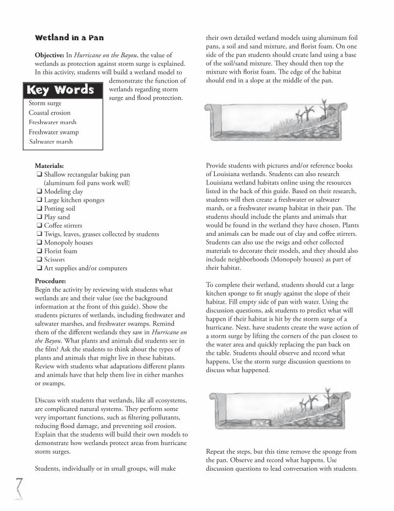
Objective: In Hurricane on the Bayou, the value of wetlands as protection against storm surge is explained. In this activity, students will build a wetland model to
demonstrate the function of wetlands regarding storm surge and fl ood protection.
Materials: ❑ Shallow rectangular baking pan (aluminum foil pans work well) ❑ Modeling clay ❑ Large kitchen sponges ❑ Potting soil ❑ Play sand ❑ Coff ee stirrers ❑ Twigs, leaves, grasses collected by students ❑ Monopoly houses ❑ Florist foam ❑ Scissors ❑ Art supplies and/or computers
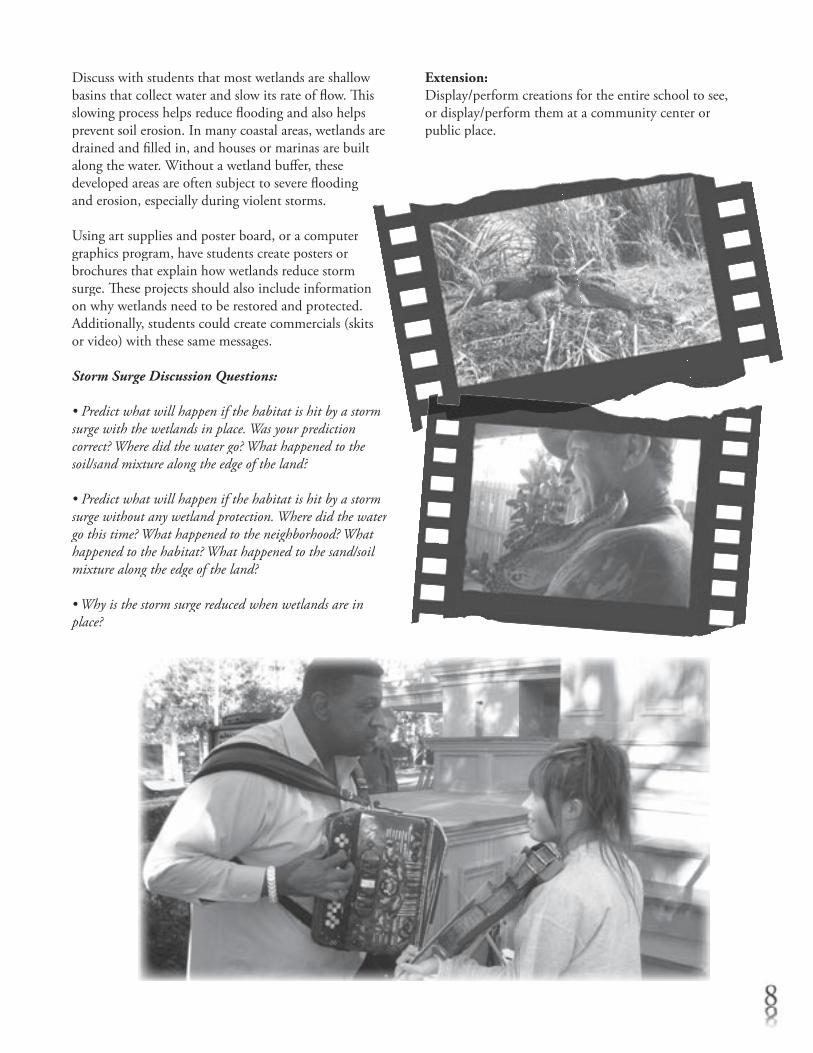
Procedure:Begin the activity by reviewing with students what wetlands are and their value (see the background information at the front of this guide). Show the students pictures of wetlands, including freshwater and saltwater marshes, and freshwater swamps. Remind them of the diff erent wetlands they saw in Hurricane on the Bayou. What plants and animals did students see in the fi lm? Ask the students to think about the types of plants and animals that might live in these habitats. Review with students what adaptations diff erent plants and animals have that help them live in either marshes or swamps.
Discuss with students that wetlands, like all ecosystems, are complicated natural systems. Th ey perform some very important functions, such as fi ltering pollutants, reducing fl ood damage, and preventing soil erosion. Explain that the students will build their own models to demonstrate how wetlands protect areas from hurricane storm surges.
Students, individually or in small groups, will make
their own detailed wetland models using aluminum foil pans, a soil and sand mixture, and fl orist foam. On one side of the pan students should create land using a base of the soil/sand mixture. Th ey should then top the mixture with fl orist foam. Th e edge of the habitat should end in a slope at the middle of the pan.
Provide students with pictures and/or reference books of Louisiana wetlands. Students can also research Louisiana wetland habitats online using the resources listed in the back of this guide. Based on their research, students will then create a freshwater or saltwater marsh, or a freshwater swamp habitat in their pan. Th e students should include the plants and animals that would be found in the wetland they have chosen. Plants and animals can be made out of clay and coff ee stirrers. Students can also use the twigs and other collected materials to decorate their models, and they should also include neighborhoods (Monopoly houses) as part of their habitat.
To complete their wetland, students should cut a large kitchen sponge to fi t snugly against the slope of their habitat. Fill empty side of pan with water. Using the discussion questions, ask students to predict what will happen if their habitat is hit by the storm surge of a hurricane. Next, have students create the wave action of a storm surge by lifting the corners of the pan closest to the water area and quickly replacing the pan back on the table. Students should observe and record what happens. Use the storm surge discussion questions to discuss what happened.
Repeat the steps, but this time remove the sponge from the pan. Observe and record what happens. Use discussion questions to lead conversation with students.
Key WordsStorm surgeCoastal erosionFreshwater marshFreshwater swampSaltwater marsh
Discuss with students that most wetlands are shallow basins that collect water and slow its rate of fl ow. Th is slowing process helps reduce fl ooding and also helps prevent soil erosion. In many coastal areas, wetlands are drained and fi lled in, and houses or marinas are built along the water. Without a wetland buff er, these developed areas are often subject to severe fl ooding and erosion, especially during violent storms.
Using art supplies and poster board, or a computer graphics program, have students create posters or brochures that explain how wetlands reduce storm surge. Th ese projects should also include information on why wetlands need to be restored and protected. Additionally, students could create commercials (skits or video) with these same messages.
Storm Surge Discussion Questions:
• Predict what will happen if the habitat is hit by a storm surge with the wetlands in place. Was your prediction correct? Where did the water go? What happened to the soil/sand mixture along the edge of the land?
• Predict what will happen if the habitat is hit by a storm surge without any wetland protection. Where did the water go this time? What happened to the neighborhood? What happened to the habitat? What happened to the sand/soil mixture along the edge of the land?
• Why is the storm surge reduced when wetlands are in place?
Extension:Display/perform creations for the entire school to see, or display/perform them at a community center or public place.

Key WordsAdaptationHabitatCamoufl agePredatorPreyScutesNictitating membrane
Rain poncho
Oar/paddle
Goggles
Nose plugs
Snorkel
Tongs/fork
Flippers
Breast plateor shield
Camoufl age or shield
Waterproof skin
Tail
Nictitating membrane
Nostrils (closed)
Nostrils (open)
Spike-shaped teeth & jaws Webbed feet
Scutes
Camoufl age coloration
Protection from water
Provides power for swimming
Protects the eyes when the gator attacks prey
Keeps water out of nose Allows gator tobreathe while the rest of its body is under-water
Used to grab and hold prey
Supports body on sandy or muddy bottoms
Protects gator’s back back back
Protects alliga-tor from the sun and prevents sunburn; helps al-ligator blend into its surroundings and hide from prey or other predators.
Prop Adaptation Function
Dress An AlligatorObjective: As seen in the fi lm, numerous animals live and thrive in the wetlands. Each animal has adaptations
and strategies that help them survive in that habitat. Students will be able to name animal adaptations, and describe their functions.
Materials: ❑ A canvas tote or duff el bag ❑ Rain poncho ❑ Small oar or paddle ❑ Swim goggles ❑ Nose plug ❑ Snorkel ❑ Kitchen tongs/fork ❑ Swim fl ippers ❑ Plastic toy breast plate (knight) ❑ Camoufl age shirt
Procedure:Using the discussion questions, talk with students about how animals must have adaptations to survive. Next, explain that the class will look at an example of an animal with wetland adaptations, and ask for a volunteer (preferably one with a sense of humor).
Explain that the class is going to turn the volunteer into an alligator. Various objects will represent the adaptations of the alligator, or the physical structures and functions that enable the animal to survive in its environment.
Place the following items on the “volunteer alligator” and ask for suggestions about the meaning of the prop and the usefulness of the adaptation it represents. Explain how the item represents an adaptation of alligators.
Discussion Questions:• What is a habitat?
• What is an adaptation? How do adaptations help animals survive? Ask students to think of examples of animal adaptations.
• Describe what a freshwater marsh or swamp looks like.What would it be like to live there? What kind of adapta-tions do you think animals need to survive in those habitats (good swimmer, camoufl age, etc.)? • What were some of the animals featured in the fi lm? Did you notice any adaptations these animals might have for living in wetlands?
Extension: Students can select another wetland animal, and develop their own “Dress an Animal” activity. Students can share what they’ve created with the class.
Prop Adaptation Function
A canvas tote or duff el bag
Small oar or paddle
Rain poncho
Oar/paddle
Goggles
Nose plugs
Snorkel
Using the discussion questions, talk with students about how animals must have adaptations to survive.
Small oar or paddle
Nose plug
Kitchen tongs/fork
Small oar or paddle
Nose plug
Kitchen tongs/fork
Key WordsSaltwater marshFreshwater marshHabitatErosionAgricultureUrban areas
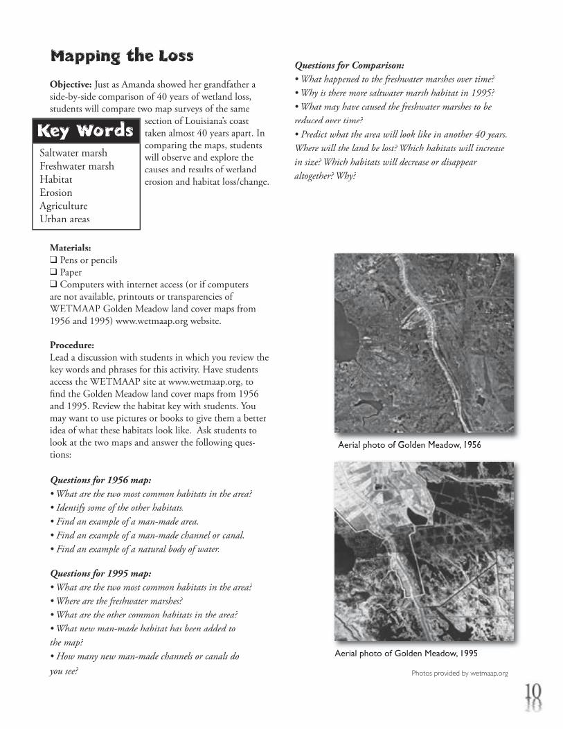
Aerial photo of Golden Meadow, 1956Aerial photo of Golden Meadow, 1956
Aerial photo of Golden Meadow, 1995
Photos provided by wetmaap.org
Mapping the Loss
Objective: Just as Amanda showed her grandfather a side-by-side comparison of 40 years of wetland loss, students will compare two map surveys of the same
section of Louisiana’s coast taken almost 40 years apart. In comparing the maps, students will observe and explore the causes and results of wetland erosion and habitat loss/change.
Materials:❑ Pens or pencils❑ Paper❑ Computers with internet access (or if computers are not available, printouts or transparencies of WETMAAP Golden Meadow land cover maps from 1956 and 1995) www.wetmaap.org website.
Procedure:Lead a discussion with students in which you review the key words and phrases for this activity. Have students access the WETMAAP site at www.wetmaap.org, to fi nd the Golden Meadow land cover maps from 1956 and 1995. Review the habitat key with students. You may want to use pictures or books to give them a better idea of what these habitats look like. Ask students to look at the two maps and answer the following ques-tions:
Questions for 1956 map:• What are the two most common habitats in the area?• Identify some of the other habitats.• Find an example of a man-made area.• Find an example of a man-made channel or canal.• Find an example of a natural body of water.
Questions for 1995 map:• What are the two most common habitats in the area?• Where are the freshwater marshes?• What are the other common habitats in the area?• What new man-made habitat has been added to the map?• How many new man-made channels or canals do you see?
Questions for Comparison:• What happened to the freshwater marshes over time?• Why is there more saltwater marsh habitat in 1995?• What may have caused the freshwater marshes to be reduced over time?• Predict what the area will look like in another 40 years. Where will the land be lost? Which habitats will increase in size? Which habitats will decrease or disappear altogether? Why?
Key WordsLongitudeLatitudeStorm intensityMillibarsKnots
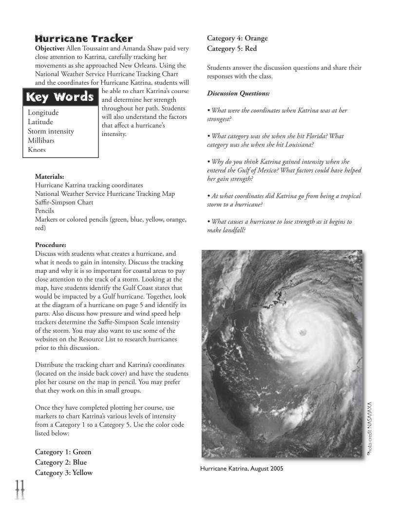
Hurricane Katrina, August 2005
Phot
o cr
edit
NA
SA/JA
XA
Phot
o cr
edit
NA
SA/JA
XA
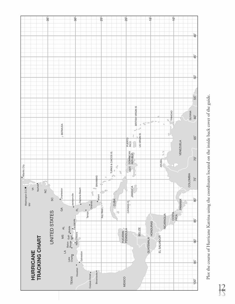
Hurricane TrackerObjective: Allen Toussaint and Amanda Shaw paid very close attention to Katrina, carefully tracking her movements as she approached New Orleans. Using the National Weather Service Hurricane Tracking Chart and the coordinates for Hurricane Katrina, students will
be able to chart Katrina’s course and determine her strength throughout her path. Students will also understand the factors that aff ect a hurricane’s intensity.
Materials:Hurricane Katrina tracking coordinatesNational Weather Service Hurricane Tracking Map Saffi r-Simpson ChartPencilsMarkers or colored pencils (green, blue, yellow, orange, red)
Procedure:Discuss with students what creates a hurricane, and what it needs to gain in intensity. Discuss the tracking map and why it is so important for coastal areas to pay close attention to the track of a storm. Looking at the map, have students identify the Gulf Coast states that would be impacted by a Gulf hurricane. Together, look at the diagram of a hurricane on page 5 and identify its parts. Also discuss how pressure and wind speed help trackers determine the Saffi r-Simpson Scale intensity of the storm. You may also want to use some of the websites on the Resource List to research hurricanes prior to this discussion.
Distribute the tracking chart and Katrina’s coordinates (located on the inside back cover) and have the students plot her course on the map in pencil. You may prefer that they work on this in small groups.
Once they have completed plotting her course, use markers to chart Katrina’s various levels of intensity from a Category 1 to a Category 5. Use the color code listed below:
Category 1: GreenCategory 2: BlueCategory 3: Yellow
Category 4: OrangeCategory 5: Red
Students answer the discussion questions and share their responses with the class.
Discussion Questions:
• What were the coordinates when Katrina was at her strongest?
• What category was she when she hit Florida? What category was she when she hit Louisiana?
• Why do you think Katrina gained intensity when she entered the Gulf of Mexico? What factors could have helped her gain strength?
• At what coordinates did Katrina go from being a tropical storm to a hurricane?
• What causes a hurricane to lose strength as it begins to make landfall?
55˚
50˚
45˚
40˚
10˚
15˚
20˚
25˚
30˚
35˚
100˚
95˚
90˚
85˚
80˚
75˚
70˚
65˚
60˚
VE
NE
ZU
ELA
CO
LOM
BIA
PAN
AM
A
NIC
AR
AG
UA
EL
SA
LVA
DO
RHO
ND
UR
AS
YU
CAT
AN
PE
NIN
SU
LA
BE
LIZ
E
CO
STA
RIC
A
ME
XIC
O
TEX
AS
LAM
SA
L
FL
SC
NC
GA
CU
BA
JAM
AIC
A
CAY
MA
N IS
PU
ER
TOR
ICO
DO
MIN
ICA
NR
EP
UB
LIC
HA
ITI
BE
RM
UD
A
VAW
V
Atla
ntic
City
Nor
folk
Cha
rlest
on
Was
hing
ton
D.C
.
Jack
sonv
ille
Day
tona
Bea
ch
Mia
mi
Tam
pa
Orla
ndo
Pen
saco
laN
ew O
rlean
s
Bat
on
Rou
geLa
ke
Cha
rles
Gal
vest
on
Hou
ston
Mob
ileG
ulf-
por
t
Key
Wes
t
BA
HA
MA
S
TUR
KS
& C
AIC
OS
IS.
US
VIR
GIN
IS
UN
ITE
D S
TATE
S
HU
RR
ICA
NE
TR
AC
KIN
G C
HA
RT
BR
ITIS
H V
IRG
IN IS
TRIN
IDA
D
GU
YAN
A
AR
UB
A
Cor
pus
Chr
isti
Bro
wns
ville
GU
ATE
MA
LA
Plot
the
cour
se o
f Hur
rican
e K
atrin
a us
ing
the
coor
dina
tes l
ocat
ed o
n th
e in
side
back
cov
er o
f the
gui
de.
Key WordsHurricane preparednessEssential needsHurricane safetySaffi r-Simpson Scale
Toussaint’s TrunkObjective: As the fi lm explains, gas, power, and water services were disrupted by Katrina. Communications, including cell phones, broke down. Many New Orleani-ans, like Allen Toussaint, decided to ride out the storm.
Th ese people needed to have supplies and an emergency plan in place. Students will work in small groups to explore and determine what supplies and preparations are needed in order to ride out a hurricane.
Materials: ❑ Blank index cards or slips of paper (enough so that each group has 25)❑ Pens or pencils❑ Brown paper sandwich bags (one per group)
Using the discussion questions, ask students to describe what they think happens during a hurricane. You may want to review the Saffi r-Simpson Scale categories on page 6 to determine what conditions may be like for those who choose to stay and ride out a storm. Lead a conversation about the conditions in New Orleans during and after Katrina. Students can do online research at the Hurricane Strike! website listed in the Hurricane Strike! website listed in the Hurricane Strike!Resources section of this guide, or search for news articles about Katrina.
Guide students in a discussion to identify fi ve critical categories for hurricane supplies: Food (non-perish-able); Health (fi rst aid kit, prescription medications); Safety and Shelter (securing yard items, boarding windows, gathering supplies); Communication (bat-tery-operated radio, cell phone, satellite phone); and Creature Comforts (games, toys, etc.).
Break students into small groups and distribute bags and cards. Instruct students to decide what they would need to ride out a hurricane. Students should identify fi ve items for each supply category. Th ey should write each item on a separate card, and place cards in the bag. Once the groups are fi nished assembling their kits, bring the class back together and ask each group to report on what they chose to include in their kit, giving reasons for inclusion. Now ask each group to prioritize the items in each category from most important to least important. Bring the class back together and use discussion questions to talk about how they prioritized their items.
Have students create a brochure, public service announcement video, commercial, or poster about hurricane safety and preparedness. Videos could be included in school library. Posters could be displayed at school. Commercials could be performed at a school assembly or other event.
Discussion Questions:• Describe what you think happens during a hurricane. What city services are unavailable? Imagine and describe what conditions would be like in a Category 4 or 5 hurricane.
• What amenities would you lose in your home during a hurricane if you lost electricity? Natural gas? Water?
• How would you get important information, news, or announcements about the hurricane and conditions in the city? How would you get in touch with family and friends?
• What would you do if you became sick or injured?
• What would you need to do in order to prepare your house and property before the storm?
• It could be several hours or days before electricity and water are restored. How will you and your family pass the time to keep from getting bored?
• Once you’ve prioritized your items, explain why you put them in that order. After hearing all the other groups’ lists, would you change your list? Would you change the way you prioritized your list?
Extension:After completing this activity, ask students to compile a similar supply list of what they might need if they chose to evacuate, as Amanda and her family did, rather than stay for the hurricane.
Key WordsWetland restorationWetland erosionCity planningZoning lawsCompromiseDebate
Town Hall Meeting: Creating a BalanceTown Hall Meeting: Creating a BalanceTown Hall Meeting:
Objective: As noted in the fi lm, alligators that were endangered 40 years ago in Louisiana are now found in abundance – thanks to good management and planning by the people and leaders of Louisiana. Planning and
management can also save the wetlands. In this activity students will explore this idea by conducting a simulated town hall meeting. Students will debate the issues that balance the economic needs of a fi ctitious town with the need to preserve wetland habitat.
Procedure:In Hurricane on the Bayou, the musicians talk about the importance of wetland restoration and creating a balance between man and nature. In this activity, students will conduct a mock debate in which an imaginary town is struggling to fi nd this balance. Students will be broken up into small groups, each group representing a diff erent town voice in the debate.
Using the discussion questions, talk with students about some of the causes of wetland erosion in Louisiana and some of the restoration projects discussed in Hurricane on the Bayou. Ask students to do some additional research with the online resources listed in the back of this guide. Review their research fi ndings as part of the discussion.
Explain to students that they will be participating in a mock town hall meeting to discuss a new development project. If possible, invite a city council member or a member of the Planning and Zoning Commission to participate in or observe your town hall meeting. Th ese people can off er suggestions about issues that might not have been considered, or they can answer student questions about how this process works. Have the council member or zoning member circulate and off er suggestions to each group before the debate begins.
Introduce students to the issue they will debate: a group of industrial businessmen would like to create a new shipping channel through a local wetland area. Th is channel would increase oil and gas business in the area, create new jobs, and bring money to the town –
something the town needs very badly.
Select groups of students to represent the following groups:
City Council Members Th is group will be listening to the debate and must make the fi nal decision on the issue.
Oil and Gas Industry Business people who would like to create the new shipping channel through a local wetland. Th e business people argue that this project would bring jobs and more money to the town.
Homeowners Local residents whose property is already threatened by the loss of wetlands due to erosion. Th ese people are not in favor of the new channel, and are worried that it will make the erosion problem worse.
Environmental Group Th is activist group does not want the new channel built at all. Its members feel that this project would be devastating to the local wildlife, removing critical habitat for numerous species of plants and animals. Th e group is opposed to any type of land development in the local wetland.
Concerned Citizens Th is group will not be directly aff ected by the new channel. While its members do not want to see the erosion problem increase, they are more interested in creating new jobs for the town. Th ey feel that jobs are more important than the wetlands. Th is group is in favor of the new shipping channel.
Wildlife and Fisheries Agents Th ese people represent the state and/or federal government’s interests in enforcing environmental laws. Th is group recognizes the importance of the project to the town but wants the channel to be created with wetland protection laws in mind. Th ese agents do not want to see the wetlands erode even more, and they are interested in a compromise solution that meets the needs of both the town and the habitat.
Review the issue and the diff erent groups with students by using the discussion questions.
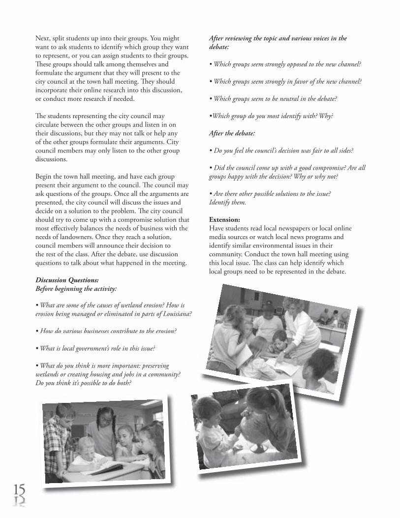
Next, split students up into their groups. You might want to ask students to identify which group they want to represent, or you can assign students to their groups. Th ese groups should talk among themselves and formulate the argument that they will present to the city council at the town hall meeting. Th ey should incorporate their online research into this discussion, or conduct more research if needed.
Th e students representing the city council may circulate between the other groups and listen in on their discussions, but they may not talk or help any of the other groups formulate their arguments. City council members may only listen to the other group discussions.
Begin the town hall meeting, and have each group present their argument to the council. Th e council may ask questions of the groups. Once all the arguments are presented, the city council will discuss the issues and decide on a solution to the problem. Th e city council should try to come up with a compromise solution that most eff ectively balances the needs of business with the needs of landowners. Once they reach a solution, council members will announce their decision to the rest of the class. After the debate, use discussion questions to talk about what happened in the meeting.
Discussion Questions:Before beginning the activity:
• What are some of the causes of wetland erosion? How is erosion being managed or eliminated in parts of Louisiana?
• How do various businesses contribute to the erosion?
• What is local government’s role in this issue?
• What do you think is more important: preserving wetlands or creating housing and jobs in a community? Do you think it’s possible to do both?
After reviewing the topic and various voices in the debate:
• Which groups seem strongly opposed to the new channel?
• Which groups seem strongly in favor of the new channel?
• Which groups seem to be neutral in the debate?
•Which group do you most identify with? Why?
After the debate:
• Do you feel the council’s decision was fair to all sides?
• Did the council come up with a good compromise? Are all groups happy with the decision? Why or why not?
• Are there other possible solutions to the issue? Identify them.
Extension:Have students read local newspapers or local online media sources or watch local news programs and identify similar environmental issues in their community. Conduct the town hall meeting using this local issue. Th e class can help identify which local groups need to be represented in the debate.
Key WordsHabitatErosionStorm buff erWetland functionsWetland restorationNatural resources
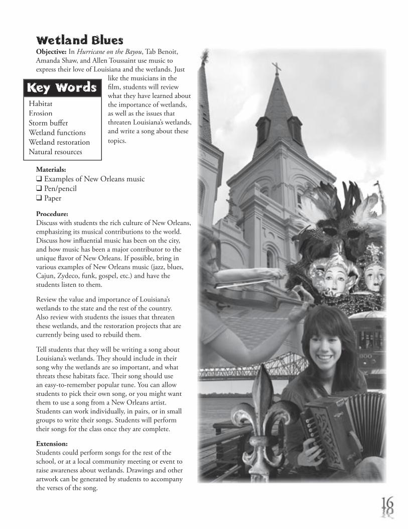
Wetland BluesObjective: In Hurricane on the Bayou, Tab Benoit, Amanda Shaw, and Allen Toussaint use music to express their love of Louisiana and the wetlands. Just
like the musicians in the fi lm, students will review what they have learned about the importance of wetlands, as well as the issues that threaten Louisiana’s wetlands, and write a song about these topics.
Materials:❑ Examples of New Orleans music❑ Pen/pencil❑ Paper
Procedure:Discuss with students the rich culture of New Orleans, emphasizing its musical contributions to the world. Discuss how infl uential music has been on the city, and how music has been a major contributor to the unique fl avor of New Orleans. If possible, bring in various examples of New Orleans music (jazz, blues, Cajun, Zydeco, funk, gospel, etc.) and have the students listen to them.
Review the value and importance of Louisiana’s wetlands to the state and the rest of the country. Also review with students the issues that threaten these wetlands, and the restoration projects that are currently being used to rebuild them.
Tell students that they will be writing a song about Louisiana’s wetlands. Th ey should include in their song why the wetlands are so important, and what threats these habitats face. Th eir song should use an easy-to-remember popular tune. You can allow students to pick their own song, or you might want them to use a song from a New Orleans artist. Students can work individually, in pairs, or in small groups to write their songs. Students will perform their songs for the class once they are complete.
Extension:Students could perform songs for the rest of the school, or at a local community meeting or event to raise awareness about wetlands. Drawings and other artwork can be generated by students to accompany the verses of the song.
Glossary
Adaptation – A body part or behavior that helps a plant or animal to survive
Camoufl age – Protective coloring that helps an animal hide
Conservation – Planned management of a natural resource to prevent exploitation, destruction or neglect
Erosion – Wearing away or corrosion
Freshwater marsh – A wetland in which grasses are the predominant vegetation
Habitat – Th e environment in which an organism livesHabitat – Th e environment in which an organism livesHabitat
Knots (kt) – A measurement of speed in nautical miles per hour
Latitude – Imaginary lines that run parallel to the Equator on the surface of the Earth that measure how far north or south of the Equator a place is located
Longitude – Imaginary lines running north to south on the surface of the Earth that measure how far east or west of the Prime Meridian a place is located
Millibars – Unit of atmospheric pressure used to measure the intensity of a hurricane
Natural resources – Th ings found in nature that are useful to people. Land, water, air, soil, minerals, plants and animals are all considered natural resources.
Non-point source pollution – Water pollution that comes from indistinct sources; it cannot be traced directly to a single source.
Point source pollution – Pollution that comes from a single point, such as pipes, ditches, wells, vessels, and containers
Pollutant – A substance that contaminates anPollutant – A substance that contaminates anPollutantenvironment
Predator – An organism that captures another Predator – An organism that captures another Predatororganism to obtain food
Prey – An animal taken by a predator as foodPrey – An animal taken by a predator as foodPrey
Runoff – Rainfall not absorbed by soil. Th is rainfall can Runoff – Rainfall not absorbed by soil. Th is rainfall can Runoff carry non-point source pollution into waterways.
Saffi r-Simpson Scale – A scale that measures the damage potential and intensity of a hurricane using a scale of 1 to 5
Saltwater marsh – A wetland occurring along the coast, where grasses are the predominant vegetation
Storm surge – An increase in water level associated with a hurricane or other strong storm
Swamp – A wetland in which the soil is saturated and often inundated with water. Trees are the dominant vegetation.
Watershed – Th e entire area that contributes surface Watershed – Th e entire area that contributes surface Watershedrunoff to a given drainage system
Wetland – An area that, at least periodically, has waterlogged soil or is covered with a shallow layer of water. Wetlands support plants and animals that are adapted to living in a watery environment. Bogs, freshwater and saltwater marshes, and swamps are examples of wetlands.
Wetland restoration – An activity that re-establishes the habitat and functions of a former wetland
Hurricane on the BayouEducator’s Guide Credits
Writer Tricia LeBlanc, Director of Education and Volunteers, Audubon Aquarium of the Americas
Teacher Review Panel Jean May-Brett Wendy DeMers Ranell Troxler Janice Catledge Jan Mistich
Design, Illustrations & Graphics Terry Kenney, Director of Graphics, Audubon Zoo Mignon Byler
National Science Education Standards
Guide Activity Standard A Standard C Standard D Standard E Standard FActivity Standard A Standard C Standard D Standard E Standard FActivity
Wetland in a Pan ¸ ¸ ¸Hurricane Tracker ¸ ¸ ¸ ¸Dress an Alligator ¸ ¸ Mapping the Loss ¸ ¸ ¸ ¸Toussaint’s Trunk ¸ ¸Town Hall Meeting ¸ ¸ ¸Wetland Blues ¸ ¸ ¸
Wetland Literature Resource List
Books for Children
***Reading Levels: (P) Primary (I) Intermediate
Chattanooga Sludge. Bang, Molly. Harcourt, 1996. (I)
Th e Danger Joe Show: Back to the Bayou. Schade, Susan. Scholastic Paperbacks, 2003. (I)
Endangered Wetland Animals. Taylor, J. David. Crabtree Pub., 1992. (I)
Flood: Mississippi 1927. Duey, Kathleen & Bale, Karen. Flood: Mississippi 1927. Duey, Kathleen & Bale, Karen. Flood: Mississippi 1927 Aladdin, 1998. (I)
In the Small, Small Pond. Fleming, Denise. Henry Holt In the Small, Small Pond. Fleming, Denise. Henry Holt In the Small, Small Pond & Co., Inc., 1998. (P)
Keeper of the Swamp. Garrett, Ann. Turtle Books, 2001. (P)
Lapin Plays Possum: Trickster Tales from the Louisiana Bayou. Doucet, Sharon. Farrar, Straus & Giroux, 2002. (P)
Liza Lou and the Yeller Belly Swamp. Mayer, Mercer. Aladdin Library, 1997. (P)
Th e Missing ‘Gator of Gumbo Limbo. Craighead George, Jean. Harper Trophy, 1993. (I)
Th e Moon of the Alligators. Craighead George, Jean. HarperCollins Juvenile Books, 1991. (I)
My Louisiana Sky. Holt, Kimberly Willis. Yearling Books, 2000. (I)
Not My Skin! Wood, Jeanne. Prilla Publishing, 1995. Not My Skin! Wood, Jeanne. Prilla Publishing, 1995. Not My Skin! (I)
Spoonbill Swamp. Guiberson, Brenda G. Henry Holt & Co., Inc. 1994. (P)
Swamp. Silver, Donald. McGraw-Hill, 1997. (P)
Swamp: Bayou Teche, Louisiana, 1851. Duey, Kathleen & Bale, Karen. Aladdin, 1999. (I)
Swamp Life (Look Closer). Greenaway, Th eresa. DK Pub Merchandise, 2000. (P)
T-Boy of the Bayou. McGraw, Wayne T. Carolrhoda Books, 2002. (P)
What are Wetlands? (Science of Living Th ings). Kalman, Bobbie. Crabtree Publishing, 2000. (P)
Wild and Swampy. Arnosky, Jim. HarperCollins Juvenile Books, 2000. (I)
Books for Teachers
Bayou Farewell: Th e Rich Life and Tragic Death of Louisiana’s Cajun Coast. Tidwell, Mike. Pantheon Books, 2003.
Holding Back the Sea: Th e Struggle for America’s Natural Legacy on the Gulf Coast. Hallowell, Christopher. HarperCollins, 2001.
Lessons on the Lake: An Educator’s Guide to the Pontchartrain Basin. Th e Lake Pontchartrain Basin Foundation, 1997.
Project WET. Western Regional Environmental Education Council, 1983.

Project WILD. Western Regional Environmental Education Council, 1983.
Rising Tide: Th e Great Mississippi Flood of 1927 and How It Changed America. Barry, John. Simon and Schuster, 1998.
Saving Louisiana? Th e Battle for Coastal Wetlands. Streever, Bill. University Press of Mississippi, 2001.
Welcome to the Wetlands: An Activity Book for Teachers. Society for Environmental Education, 1993.
WOW! Th e Wonders of the Wetlands. Kesselheim, Alan. Environmental Concern, 1995.
Wetland Links
Audubon Nature Institute – Wild-lab.comwww.wild-lab.com
Hurricane Strikehttp://meted.ucar.edu/hurrican/strike/orig/index.htm
Wetland Education through Maps and Aerial Photographywww.wetmaap.org
America’s Wetlandwww.americaswetland.com
Marsh Missionwww.marshmission.com
National Wetlands Research Centerwww.nwrc.usgs.gov
National Wetlands Research Center – Louisianawww.lacoast.gov
Th e Lake Pontchartrain Basin Foundationwww.saveourlake.org
NASA websitehttp://www.nasa.gov
Th e Barataria Terrebonne National Estuary Programwww.btnep.org
National Geographicwww.nationalgeographic.com
Department of Natural Resourceswww.dnr.state.la.us/teach.ssi
National Wetlands Inventorywww.nwi.fws.gov
Ducks Unlimited for Kidshttp://www.greenwing.org/dueducator/noncssdu_educator.htm
Times Picayune: Katrina Interactivehttp://www.nola.com/katrina/graphics/fl ashfl ood.swf
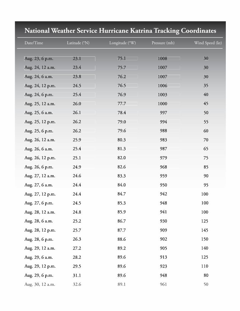
National Weather Service Hurricane Katrina Tracking Coordinates
Date/Time Latitude (°N) Longitude (°W) Pressure (mb) Wind Speed (kt)
Aug. 23, 6 p.m. 23.1 75.1 1008 30
Aug. 24, 12 a.m. 23.4 75.7 1007 30
Aug. 24, 6 a.m. 23.8 76.2 1007 30
Aug. 24, 12 p.m. 24.5 76.5 1006 35
Aug. 24, 6 p.m. 25.4 76.9 1003 40
Aug. 25, 12 a.m. 26.0 77.7 1000 45
Aug. 25, 6 a.m. 26.1 78.4 997 50
Aug. 25, 12 p.m. 26.2 79.0 994 55
Aug. 25, 6 p.m. 26.2 79.6 988 60
Aug. 26, 12 a.m. 25.9 80.3 983 70
Aug. 26, 6 a.m. 25.4 81.3 987 65
Aug. 26, 12 p.m. 25.1 82.0 979 75
Aug. 26, 6 p.m. 24.9 82.6 968 85
Aug. 27, 12 a.m. 24.6 83.3 959 90
Aug. 27, 6 a.m. 24.4 84.0 950 95
Aug. 27, 12 p.m. 24.4 84.7 942 100
Aug. 27, 6 p.m. 24.5 85.3 948 100
Aug. 28, 12 a.m. 24.8 85.9 941 100
Aug. 28, 6 a.m. 25.2 86.7 930 125
Aug. 28, 12 p.m. 25.7 87.7 909 145
Aug. 28, 6 p.m. 26.3 88.6 902 150
Aug. 29, 12 a.m. 27.2 89.2 905 140
Aug. 29, 6 a.m. 28.2 89.6 913 125
Aug. 29, 12 p.m. 29.5 89.6 923 110
Aug. 29, 6 p.m. 31.1 89.6 948 80
Aug. 30, 12 a.m. 32.6 89.1 961 50
Th e Joe W. W. W and Dorothy Dorsett Brown Foundation