Embed Size (px)
Citation preview
Impact of Secondary Eyewall Heating on Tropical Cyclone Intensity Change*
XIAQIONG ZHOU, BIN WANG, XUYANG GE, AND TIM LI
International Pacific Research Center, and Department of Meteorology, School of Ocean and Earth Science
and Technology, University of Hawaii at Manoa, Honolulu, Hawaii
(Manuscript received 3 August 2010, in final form 22 October 2010)
ABSTRACT
The primary goal of this study is to explore the factors that might influence the intensity change of tropical
cyclones (TCs) associated with secondary eyewall replacement. Concentric eyewall structures in TCs with and
without large intensity weakening are compared using the Tropical Rainfall Measuring Mission (TRMM)
2A12 and 2A25 data. It is found that the secondary eyewalls with a stratiform-type heating profile show
a marked weakening, while those TCs with a convective-type heating weaken insignificantly or even intensify.
This observed feature is supported by a set of sensitivity numerical experiments performed with the Weather
Research and Forecasting model. With more active convection, the latent heat released in the outer eyewall
and moat region can better sustain storm intensity. The prevailing stratiform precipitation results in low
equivalent potential temperature air in the moat and reduces the entropy of the boundary layer inflow to the
inner eyewall through persistent downdrafts, leading to a large intensity fluctuation. Comparison of obser-
vations and numerical model results reveals that the model tends to overproduce convective precipitation in
the outer eyewall and the moat. It is possible that the model underestimates the storm intensity changes
associated with eyewall replacement events.
1. Introduction
Concentric eyewalls usually refer to two or more
quasi-circular eyewalls separated by a convective mini-
mum region, known as a moat, in intense tropical cyclones
(TCs) (Fortner 1956; Willoughby et al. 1982; Black and
Willoughby 1992; Hawkins et al. 2006). As the outer
eyewall forms, the inner one weakens and is eventually
replaced by the outer one. Large intensity fluctuations
are usually expected. However, observations show that
intensity changes associated with eyewall replacement
can vary greatly with cases. For example, an abrupt de-
crease in the maximum wind speed as large as 46 m s21
was detected in Typhoon Sarah (1956), but the appear-
ance of the concentric eyewalls in Hurricane Anita (1977)
only marks the end of a deepening phase (Fortner 1956;
Willoughby et al. 1982). Kuo et al. (2009) examined the
intensity changes before and after concentric eyewall
formation over the western North Pacific (WNP). The
storms that intensify before the secondary eyewall for-
mation but weaken afterward account for about 49% of
all cases. In about 22% of cases, the formation of sec-
ondary eyewalls only slows down the intensification rate.
In about 4% of the concentric eyewall cases, the weak-
ening storms even gain intensity after the secondary
eyewall formation. The diversity of the intensity changes
in TCs with secondary eyewalls suggests that accurate
intensity forecasts are not guaranteed even if we can
predict the formation of secondary eyewalls.
Our ability to observe concentric eyewalls has been
greatly improved through in situ means and by remote
sensing. The passive microwave remote sensing can pen-
etrate the upper-level cloud shield and allow us to view
the storm convective structures with more clarity. Con-
centric eyewall events can be successfully identified by
utilizing passive microwave products for global tropical
cyclone monitoring (Hawkins et al. 2006; Kossin and
Sitkowski 2009; Kuo et al. 2009). However, the detailed
structures of concentric eyewalls have not been examined.
The primary goals of this study are (a) to investigate
whether the thermodynamic structures differ between the
concentric eyewall TCs with and without large intensity
* School of Ocean and Earth Science and Technology Contri-
bution Number 8040 and International Pacific Research Center
Contribution Number 735.
Corresponding author address: Xiaqiong Zhou, University of
Hawaii, 2525 Correa Rd., HIG 351A, Honolulu, HI 96822.
E-mail: [email protected]
450 J O U R N A L O F T H E A T M O S P H E R I C S C I E N C E S VOLUME 68
DOI: 10.1175/2010JAS3624.1
� 2011 American Meteorological Society
fluctuation and (b) to investigate whether the secondary
eyewalls and associated intensity fluctuation simulated by
numerical models are consistent with the observations.
2. Data and methodology
The Tropical Rainfall Measuring Mission (TRMM)
2A12 dataset (Olson et al. 2006) is generated from TRMM
Microwave Imager (TMI) brightness temperatures by
blending the radiometric data with dynamical cloud models.
The swath width of the TRMM 2A12 is 878 km. The
dataset has 5.1-km horizontal resolution and 14 vertical
layers from the surface to 18.0 km. The TRMM 2A25
(Iguchi et al. 2000) provides three-dimensional rain rate
and radar reflectivity measured by the TRMM Pre-
cipitation Radar (PR) with 247-km swath width and 5-km
horizontal resolution. The limited spatial and temporal
coverage cannot describe the entire cycle of eyewall re-
placement, but it provides some snapshots of TCs with
concentric eyewall structure.
The cases with quasi-circular secondary eyewalls cap-
tured by TRMM orbits are selected. To avoid the in-
fluence of the cold underlying ocean surface or frictional
boundary on storm intensity, storms moving north of
258N or close to land are discarded. As a result, only a
few cases are available.
The track and intensity of each storm come from the
best-track database of the Joint Typhoon Warning Center
(JTWC). Two sample groups of TCs are classified based
on the intensity fluctuation. In the first group, the ty-
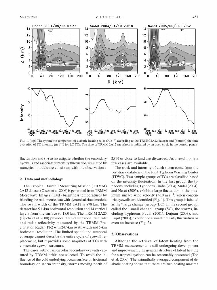
phoons, including Typhoons Chaba (2004), Sudal (2004),
and Nesat (2005), exhibit a large fluctuation in the max-
imum surface wind velocity (.10 m s21) when concen-
tric eyewalls are identified (Fig. 1). This group is labeled
as the ‘‘large change’’ group (LC). In the second group,
called the ‘‘small change’’ group (SC), the storms, in-
cluding Typhoons Pudal (2001), Dujuan (2003), and
Lupit (2003), experience a small intensity fluctuation or
even an increase (Fig. 2).
3. Observations
Although the retrieval of latent heating from the
TRMM measurements is still undergoing development
and improvement, the general structure of latent heating
for a tropical cyclone can be reasonably presented (Tao
et al. 2006). The azimuthally averaged component of di-
abatic heating shows that there are two heating maxima
FIG. 1. (top) The symmetric component of diabatic heating rates (K h21) according to the TRMM 2A12 dataset and (bottom) the time
evolution of TC intensity (m s21) for LC TCs. The time of TRMM 2A12 snapshots is indicated by an open circle in the bottom panels.
MARCH 2011 Z H O U E T A L . 451
associated with each of the concentric eyewalls (Figs. 1
and 2). The inner eyewalls are expected to decay after the
formation of the secondary eyewalls. Since they remain
much stronger and extend deeper into the free atmo-
sphere than the outer ones in these six snapshots, it sug-
gests that the storms observed are at the early stage of the
eyewall replacement. In LC, the heating (cooling) occurs
above (below) a height of 3 km in the moat and outer
eyewall region. The upper-level heating shows a flat top
below 10 km in the outer eyewall. Generally, the low-
level diabatic cooling is a result of the evaporation of rain
droplets or snow melting below the freezing level. The
heating profile suggests that stratiform-type precipitation
prevails in the outer region. Meanwhile, the storm weakens
rapidly when concentric eyewalls are identified. A weak
reintensification following the rapid decay in Typhoons
Chaba (2004) and Sudal (2004) is a result of the contraction
and the organization of the outer eyewalls (not shown).
In contrast, strong convective heating of the outer
eyewalls in SC penetrates upward beyond 14 km, which is
much deeper than those in LC. Meanwhile, the cooling
rate below the freezing level is much weaker. The results
suggest that convective precipitation dominates in the
outer region. Notice that there is no significant intensity
change in Typhoons Podul (2001) and Lupit (2003), and
Typhoon Dujuan (2003) even intensifies after the sec-
ondary eyewall forms.
TRMM 2A25 provides more accurate data since it
directly measures the intensity of convection. However,
its swath width is much narrower than that of 2A12, so
only four of six TCs of interest are captured. In this
study, maximum radar reflectivity in the vertical that ex-
ceeds 40 dBZ is considered deep convection. The cover-
age of deep convection reaches the peak in concentric
eyewalls (Fig. 3). The proportion of deep convection in
the outer eyewalls is below 35% in LC, whereas it reaches
60% in SC.
The observations suggest that intensity change asso-
ciated with secondary eyewall replacement is related to
the thermodynamic features of the outer eyewall and the
moat. Active deep convection in the outer eyewall and
the moat region likely leads to a small intensity fluctua-
tion or even an increase during the eyewall replacement,
whereas more stratiform-like precipitation prevailing in
these areas is responsible for a large intensity fluctuation.
Admittedly, the number of samples is too small to con-
duct a statistical test. Therefore, we conduct a set of
numerical sensitivity experiments to confirm the TRMM
findings.
4. Sensitivity experiments
It is generally accepted that broad-scale downdrafts
indicative of stratiform rain are initiated and maintained
FIG. 2. As in Fig. 1, but for SC TCs.
452 J O U R N A L O F T H E A T M O S P H E R I C S C I E N C E S VOLUME 68
by light ice particles (Lord et al. 1984; Willoughby et al.
1984; Tao and Simpson 1989). To change the proportion
of deep convection and stratiform clouds, two sensitivity
numerical experiments were conducted using the Weather
Research and Forecasting (WRF) model. The model is
conducted in a quadruply nested two-way interactive
mode with the horizontal resolutions of 54, 18, 6, and
2 km, respectively, and 28 levels in the vertical. The
vortex is embedded on an f plane centered at 188N in
a quiescent environment over the ocean with a constant
sea surface temperature of 298C. A detailed description
of the control experiment can be found in Zhou and
Wang (2009). The sensitivity run (hereafter ICE) makes
use of identical initial conditions and model parameters
as the control run (CTL), except that concentrations of
ice particles in the microphysics package (Lin et al. 1983)
are enhanced. The formation of a secondary eyewall and
eyewall replacement are well simulated in both experi-
ments. The full cycles of the secondary eyewall replace-
ment in these two experiments are compared in Zhou and
Wang (2011). Here, only the thermodynamic features
of concentric eyewalls and associated intensity fluctua-
tion are examined to compare with the observations
(Figs. 4 and 5).
The modification of the ice-phase microphysics signif-
icantly affects concentric eyewall structures. The outer
eyewall in CTL is located closer to the inner one than in
ICE, and the cooling in the moat is weaker (Fig. 4). The
heating rate of the secondary eyewall in CTL is larger
than in ICE, although the coverage of deep convection in
the outer eyewalls is basically similar (Fig. 5). Overall,
convection outside of the inner eyewall is more active in
CTL than in ICE. Suppressed convection in ICE is as-
cribed to the enhanced concentrations of snow and cloud
ice at the upper-tropospheric outflow layer. The storm in
ICE has a more distinct subsidence region (moat) sur-
rounding the inner eyewall than that in CTL due to the
reinforced cooling of ice particles melting as they fall into
the warm air. Note that the maximum surface wind speed
decreases more than 10 m s21 in ICE and only about
FIG. 3. The radial distributions of the deep convection coverage (maximum radar reflectivity . 40 dBZ) in (top) LC
and (bottom) SC.
MARCH 2011 Z H O U E T A L . 453
5 m s21 in CTL (Fig. 5). Apparently, the sensitivity
experiment result is consistent with the observations.
The simulated outer eyewall tilts outward with altitude,
while it is upright in the TRMM data (Figs. 1 and 2). This
is likely due to the relatively coarse horizontal resolution
(about 5 km) compared with the model (2 km). It is
worth noting that the simulated heating rate in concentric
eyewalls is generally greater than in the observed cases.
The simulated low-level cooling associated with snow
melting and evaporation is also much weaker and shal-
lower. The percentage of deep convection further in-
dicates that the model storm is too convective in the
eyewalls and moat regions (Fig. 5). The coverage of deep
convection in the outer eyewalls in the model (.80%) is
FIG. 4. The symmetric component of diabatic heating rates (K h21) averaged in the first 3 h after the formation of the
secondary eyewall in the (a) ICE and (b) CTL experiments simulated by the WRF model.
FIG. 5. (a),(b) Radial distributions of the deep convection coverage (the maximum radar reflectivity . 40 dBZ) in
(a) ICE and (b) CTL. (c),(d) Time series of storm intensity (m s21) for (c) ICE and (d) CTL. The open circles mark
the time for (a) and (b). The time of the model integration and the reference time with respect to the secondary
eyewall formation are indicated at the upper and lower x coordinates.
454 J O U R N A L O F T H E A T M O S P H E R I C S C I E N C E S VOLUME 68
much greater than in the observed cases (,60%). The
moat is almost free of deep convection (Fig. 3) in the
TRMM measurements, whereas the coverage of deep
convection in the moat is high in the model (Fig. 5). The
enhanced concentrations of ice particles in ICE lead to
a clear moat and suppressed convection in the outer
region but do not qualitatively change the heating profile.
Unrealistically strong convection simulated by the
model would result in underestimated storm intensity
fluctuations.
5. Interpretation
The diabatic heating in the outer region has a direct
effect on the storm intensity during eyewall replacement.
As the inner eyewall dies, the storm temporarily loses its
ability to produce an intense, localized warm core so the
storm weakens (Rozoff et al. 2008). The new eyewall
must have the ability to maintain a warm core not only in
the previous eye but also in the moat region to prevent
the weakening of the storm. The ability of a new eyewall
with prevailing deep convection (stratiform clouds) to
maintain the storm intensity would be high (weak). Mean-
while, the moat becomes a part of the eye after the inner
eyewall fades away. If the stratiform-type precipitation
prevails in the moat, the air in the moat is characterized
by low equilibrium potential temperature ue at the middle
levels. To recover the intensity, the low ue in the moat
must be filled. The prevailing stratiform-type precipi-
tation in the moat would lead to large intensity fluctua-
tion during eyewall replacement.
In addition to the direct influence, the storm intensity
change would be affected by the heating-induced sec-
ondary circulation. The response of secondary circula-
tions to convective- and stratiform-type heating in an
intense storm is confirmed by Moon and Nolan (2010)
using a three-dimensional, nonhydrostatic, linear model
of the vortex-anelastic equations. In the region where
stratiform-type clouds prevail, weak downdrafts and
evaporation cooling dominate below the environmental
08C level, and weak updrafts and diabatic heating appear
in the middle to upper levels. In convective regions,
strong updrafts and diabatic heating dominate through
the troposphere (Shapiro and Willoughby 1982). If
stratiform-type precipitation prevails in the outer eyewall
and moat, persistent downdrafts from the lower and
middle troposphere into the boundary layer may reduce
the boundary layer ue. From the perspective of an ide-
alized Carnot-cycle heat engine (Emanuel 1986), when
lower ue airs enter the core region of the TC, a decrease
of storm intensity can be expected (Barnes et al. 1983).
In other words, the appearance of stratiform (convective)-
type heating profiles in the outer region would lead to
a large (small) fluctuation of storm intensity during eye-
wall replacement. Since the numerical model generates
less (more) stratiform (convective)-type precipitation, this
indirect process would play a minor role in weakening
storm intensity. In this regard, the intensity fluctuation
during eyewall replacement cycles might be underesti-
mated by the model.
6. Summary
The vertical thermodynamic structures of concentric
eyewalls in those TCs with and without significant in-
tensity fluctuation are compared by using TRMM 2A12
and 2A25 satellite data. The observed features are fur-
ther examined through a set of numerical simulations by
using the Weather Research and Forecasting (WRF)
model. The model can realistically simulate secondary
eyewall replacement cycles and associated intensity
changes. Both the observation and model results suggest
that the weakening of a TC is more (less) significant when
stratiform-type (convective-type) precipitation prevails
in the secondary eyewall and the moat. The latent heating
released in a new eyewall with more active convection can
better maintain the storm intensity, whereas prevailing
stratiform precipitation in the moat and outer eyewall will
reduce the boundary layer inflow ue to the inner eyewall
through persistent downdrafts and result in low-ue air in
the moat. These two possible ways to generate low-ue air
in the inner core region could lead to a large intensity
fluctuation during the eyewall replacement. On the other
hand, the model tends to overproduce deep convection,
suggesting that the model possibly underestimates the
weakening of storm intensity associated with secondary
eyewall replacement cycles.
Acknowledgments. This research was supported by Dr.
Ramesh Kakar through NASA project NNX09AG97G.
It is also supported by ONR Grant N000141010774.
REFERENCES
Barnes, G. M., E. J. Zipser, D. P. Jorgensen, and F. D. Marks Jr.,
1983: Mesoscale and convective structure of a hurricane
rainband. J. Atmos. Sci., 40, 2125–2137.
Black, M. L., and H. E. Willoughby, 1992: The concentric eye-
wall cycle of Hurricane Gilbert. Mon. Wea. Rev., 120,
947–957.
Emanuel, K. A., 1986: An air–sea interaction theory for tropical
cyclones. Part I: Steady-state maintenance. J. Atmos. Sci., 43,585–605.
Fortner, L. E., 1956: Typhoon Sarah. Bull. Amer. Meteor. Soc., 39,
633–639.
Hawkins, J. D., M. Helveston, T. F. Lee, F. J. Turk, K. Richardson,
C. Sampson, J. Kent, and R. Wade, 2006: Tropical cyclone
multiple eyewall configurations. Extended Abstracts, 27th
MARCH 2011 Z H O U E T A L . 455
Conf. on Hurricanes and Tropical Meteorology, Monterey, CA,
Amer. Meteror. Soc., 6B.1. [Available online at http://ams.
confex.com/ams/27Hurricanes/techprogram/paper_108864.
htm.]
Iguchi, T., T. Kozu, R. Meneghine, J. Awaka, and K. Okamoto,
2000: Rain-profiling algorithm for the TRMM precipitation
radar. J. Appl. Meteor., 39, 2038–2052.
Kossin, J. P., and M. Sitkowski, 2009: An objective model for
identifying secondary eyewall formation in hurricanes. Mon.
Wea. Rev., 137, 876–892.
Kuo, H.-C., C.-P. Chang, Y.-T. Yang, and H.-J. Jiang, 2009:
Western North Pacific typhoons with concentric eyewalls.
Mon. Wea. Rev., 137, 3758–3770.
Lin, Y.-L., R. D. Farley, and H. D. Orville, 1983: Bulk parame-
terization of the snow field in a cloud model. J. Climate Appl.
Meteor., 22, 1065–1092.
Lord, S. J., H. E. Willoughby, and J. M. Piotrowicz, 1984: Role of
a parameterized ice-phase microphysics in an axisymmetric
tropical cyclone model. J. Atmos. Sci., 41, 2836–2848.
Moon, Y., and D. S. Nolan, 2010: The dynamic response of the
hurricane wind field to spiral rainband heating. J. Atmos. Sci.,
67, 1779–1805.
Olson, W. S., and Coauthors, 2006: Precipitation and latent heating
distributions from satellite passive microwave radiometry.
Part I: Improved method and uncertainties. J. Appl. Meteor.
Climatol., 45, 702–720.
Rozoff, C. M., W. H. Schubert, and J. P. Kossin, 2008: Some dy-
namical aspects of tropical cyclone concentric eyewalls. Quart.
J. Roy. Meteor. Soc., 134, 583–593.
Shapiro, L. J., and H. E. Willoughby, 1982: The response of bal-
anced hurricanes to local sources of heat and momentum.
J. Atmos. Sci., 39, 378–394.
Tao, W.-K., and J. Simpson, 1989: Modeling study of a tropical
squall-type convective line. J. Atmos. Sci., 46, 177–202.
——, and Coauthors, 2006: Retrieval of latent heating from TRMM
measurements. Bull. Amer. Meteor. Soc., 87, 1555–1572.
Willoughby, H. E., J. A. Clos, and M. G. Shoreibah, 1982: Con-
centric eye walls, secondary wind maxima, and the evolution
of the hurricane vortex. J. Atmos. Sci., 39, 395–411.
——, H.-L. Jin, S. J. Lord, and J. M. Piotrowicz, 1984: Hurricane
structure and evolution as simulated by an axisymmetric, non-
hydrostatic numerical model. J. Atmos. Sci., 41, 1169–1186.
Zhou, X., and B. Wang, 2009: From concentric eyewall to annular
hurricane: A numerical study with the cloud-resolved WRF model.
Geophys. Res. Lett., 36, L03802, doi:10.1029/2008GL036854.
——, and ——, 2011: Mechanism of concentric eyewall replace-
ment cycle and associated intensity change. J. Atmos. Sci., in
press.
456 J O U R N A L O F T H E A T M O S P H E R I C S C I E N C E S VOLUME 68