Embed Size (px)
Citation preview

THIS DOCUMENT IS UNCONTROLLED IN HARD COPY FORMAT
Rev Document Number Author Approver / BFO Approver Signature Issue Date Page
2 OP-PRO-01559 D. Tucker Manager Environment & Approval 13/05/2020 1 of 9
Impact Reconciliation Procedure
Environment
1 The Proposal and Condition Requirements
1.1 The Proposal
Roy Hill Iron Ore Pty Ltd (Roy Hill), a wholly owned subsidiary of Hancock Prospecting Pty Ltd (HPPL), currently
operates the Roy Hill Iron Ore Mine (the Mine). The Mine is located 280km south of Port Hedland and 110km
north of Newman in the Pilbara Region of Western Australia (Figure 1). The overall Roy Hill project involves the
open cut mining, processing, transport via heavy haul railway and export of bedded Marra Mamba and detrital
iron ore from port facilities in Port Hedland.
Roy Hill has submitted a Revised Proposal currently being assessed by the Western Australian Environmental
Protection Authority (EPA) and the Commonwealth Department of Environment and Energy (DoEE).
This document outlines the process for impact reconciliation for the additional impacts arising from the Revised
Proposal. The Revised Proposal includes:
An increase in the ground disturbance footprint by up to 5,995 hectares;
Life of Mine (LOM) water management strategy (including water abstraction, dewatering and Managed
Aquifer Recharge (MAR));
Revised waste material management strategy including changes to backfilling of pits and waste rock dump
locations;
Development of permanent surface water structures and;
An increase to greenhouse gas emissions.
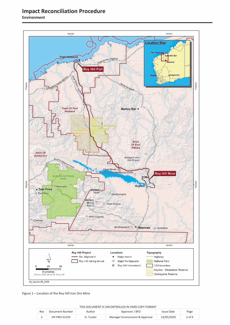
The conceptual layout within the Revised Development Envelope of the Mine is outlined on Figure 2 and Figure
3. The mining activities are undertaken within mining tenements M46/518 and M46/519. There is also a set of
miscellaneous licences for the purposes of remote borefields, access roads, dewatering, re-injection and
groundwater search activities.
Impact Reconciliation ProcedureEnvironment
THIS DOCUMENT IS UNCONTROLLED IN HARD COPY FORMAT
Rev Document Number Author Approver / BFO Issue Date Page
2 OP-PRO-01559 D. Tucker Manager Environment & Approval 13/05/2020 2 of 9
Figure 1 – Location of the Roy Hill Iron Ore Mine
Impact Reconciliation ProcedureEnvironment
THIS DOCUMENT IS UNCONTROLLED IN HARD COPY FORMAT
Rev Document Number Author Approver / BFO Issue Date Page
2 OP-PRO-01559 D. Tucker Manager Environment & Approval 13/05/2020 3 of 9
Figure 2 – Roy Hill Mine Conceptual Mine Layout within the Revised Development Envelope.

Impact Reconciliation ProcedureEnvironment
THIS DOCUMENT IS UNCONTROLLED IN HARD COPY FORMAT
Rev Document Number Author Approver / BFO Issue Date Page
2 OP-PRO-01559 D. Tucker Manager Environment & Approval 13/05/2020 4 of 9
Figure 3 - Roy Hill Mine Conceptual Borefield Layout within Revised Development Envelope.

Impact Reconciliation ProcedureEnvironment
THIS DOCUMENT IS UNCONTROLLED IN HARD COPY FORMAT
Rev Document Number Author Approver / BFO Issue Date Page
2 OP-PRO-01559 D. Tucker Manager Environment & Approval 13/05/2020 5 of 9
1.2 Condition Requirements
Ministerial Statement (MS) 824 and MS 829 permit 11,993ha of native vegetation clearing which is not subject
to offsets for vegetation clearing. The Revised Proposal is seeking an additional clearing allocation of up to
5,995ha within the mine and borefield areas. In assessing the level of significance of impact, the additional
clearing allocation of 5,995ha has been applied.
Impacts to vegetation in ‘good to excellent’ condition are not listed as an example of a significant residual impact
which will or may require an offset in the EPA (2014) WA Environmental Offsets Guidelines, however it has been
highlighted as requiring offsets by the EPA in various EPA Reports (i.e. 1533, 1610) for clearing undertaken in
the Pilbara.
2 Procedure
2.1 Identification of the Biodiversity Values Requiring Offsets
The Revised Development Envelope is located within the Fortescue and Chichester Interim Biogeographic
Regionalisation for Australia (IBRA) subregions. Based on previous EPA advice a monetary rate per hectare of
clearing should be contributed to the Pilbara Environmental Offsets Fund (PEOF) for native vegetation in ‘Good
to Excellent’ condition, which includes impacts on fauna habitat. The offset rate for clearing matters and IBRA
subregions requiring offsets can be found in Table 1.
The vegetation health and condition of the Revised Development Envelope has been mapped and quantified
through multiple flora surveys and studies as outlined in the Roy Hill Revised Proposal – Public Environmental
Review Document (OP-REP-00612). The vegetation condition was determined based on the level of disturbance
observed in an area and was assessed using the vegetation condition scale recommended by the EPA for
assessment within the Eremaean Botanical Province (EPA, 2016). Vegetation condition has been categorised
into 6 classes:
Completely Degraded
Degraded
Poor
Good
Very Good
Excellent
Figure 4 illustrates the vegetation condition mapping within the Roy Hill Revised Development Envelope.
Table 1 - Biodiversity values from Ministerial Statement (To Be Determined) that require offsets
Condition Clearing Matter IBRA Subregion Offset Rate Documented in Statement
($/ha)
- Clearing of native vegetation in good to
excellent condition
Fortescue $1632
- Clearing of native vegetation in good to
excellent condition
Chichester $771
Offset rate per hectare for IBRA sub-regions has been sourced from the PEOF webpage on the Department of
Water and Environmental Regulation website and will be subject to Consumer Price Index (CPI).

Impact Reconciliation ProcedureEnvironment
THIS DOCUMENT IS UNCONTROLLED IN HARD COPY FORMAT
Rev Document Number Author Approver / BFO Issue Date Page
2 OP-PRO-01559 D. Tucker Manager Environment & Approval 13/05/2020 6 of 9
Figure 4 - Vegetation condition mapping within the Roy Hill Revised Development Envelope.

Impact Reconciliation ProcedureEnvironment
THIS DOCUMENT IS UNCONTROLLED IN HARD COPY FORMAT
Rev Document Number Author Approver / BFO Issue Date Page
2 OP-PRO-01559 D. Tucker Manager Environment & Approval 13/05/2020 7 of 9
2.2 Methodology to Determine Clearing
Roy Hill will offset direct and indirect impacts in areas of ‘good to excellent’ vegetation condition subject to the
Revised Proposal (Figure 4). This incorporates vegetation in the Revised Development Envelope not subject to
the Original Proposal. Figure 2 and Figure 3 illustrate the ‘Proposed new clearing areas’ that will be subject to
being offset in this procedure.
2.2.1 Direct Impacts
Direct impacts to flora and vegetation within the Revised Development Envelope include clearing and ground
disturbance activities. All clearing and ground disturbance activities are undertaken in accordance with the
Ground Disturbance Permit Procedure (OP-PRO-00193). This process conditionally approves clearing on site and
progressively monitors cleared areas. The amount of clearing will be quantified through annual airborne survey
data captures. Clearing reconciliation is undertaken annually for reporting purposes.
2.2.2 Indirect Impacts
Indirect impacts, including a decline in health and/or change in vegetation composition has the potential to arise
from the following activities:
Saline water or decant water disposal for dust suppression or disposal via MAR;
Reduction in groundwater levels due to groundwater abstraction or dewatering;
Increase in groundwater levels due to groundwater re-injection;
Change in the groundwater quality due to re-injection of groundwater of a different quality to that naturally
existing;
Alteration of surface water flows;
Introduction and spread of weeds; and
Dust deposition.
Vegetation monitoring programs, as outlined in the Vegetation Condition Management Plan (OP-REP-00363),
will identify and quantify any significant indirect impacts that occur to vegetation and flora. If the vegetation is
not recoverable after a period of 5 years, and has been attributed to impact from operations, then the area of
impact will be determined and will be reported on in the relevant annual report.
3 Reporting
An Impact Reconciliation Report (IRR) outlining the disturbance undertaken in the Revised Proposal will be
completed biennially. The IRR will provide the location and spatial extent of the clearing undertaken over
relevant vegetation condition in support of the calculations made for the amount of offset payment required.
Once the new Ministerial Statement is approved, the first reconciliation report will be due at the end of the
financial year two years after the commencement of clearing operations in ‘Proposed new clearing areas’ (Table
2).

Impact Reconciliation ProcedureEnvironment
THIS DOCUMENT IS UNCONTROLLED IN HARD COPY FORMAT
Rev Document Number Author Approver / BFO Issue Date Page
2 OP-PRO-01559 D. Tucker Manager Environment & Approval 13/05/2020 8 of 9
3.1 Frequency and timingTable 2 - Reporting period and frequency of the IRR
Biennial Period Action Timing
20XX-20XX* Ministerial Statement issued -
Clearing commenced in the Revised Proposal -
Period 1** First biennial reporting period -
Aerial survey/ground truthing -
Impact Reconciliation Report submitted to DWER -
Period 2 Second biennial reporting period -
Aerial survey/ground truthing -
Impact Reconciliation Report submitted to DWER -
Period 3 Third biennial reporting period -
Aerial survey/ground truthing -
Impact Reconciliation Report submitted to DWER -
* Biennial reporting period dependant on the rate of clearing under current approvals
** Period 1 is less than two years in order to align with a financial year reporting period
3.2 Clearing and Reconciliation
The following information will be submitted in the Impact Reconciliation Report:
Clearing undertaken during the reporting period, identified via environmental value within the relevant IBRA
subregions.
Impact Reconciliation ProcedureEnvironment
THIS DOCUMENT IS UNCONTROLLED IN HARD COPY FORMAT
Rev Document Number Author Approver / BFO Issue Date Page
2 OP-PRO-01559 D. Tucker Manager Environment & Approval 13/05/2020 9 of 9
4 Abbreviations
Term Definition
CPI Consumer Price Index
DOEE Commonwealth Department of Environment and Energy
EPA Western Australian Environmental Protection Authority
IBRA Interim Biogeographic Regionalisation for Australia
IRR Impact Reconciliation Report
LOM Life of Mine
MAR Managed Aquifer Recharge
MS Ministerial Statement
PEOF Pilbara Environmental Offsets Fund
Table 3 – Abbreviations
5 References
Document number Title
OP-PRO-00193 Ground Disturbance Permit Procedure
OP-REP-00363 Vegetation Condition Management Plan
OP-REP-00612 Roy Hill Revised Proposal – Public Environmental Review Document
Table 4 – References