Embed Size (px)
Citation preview
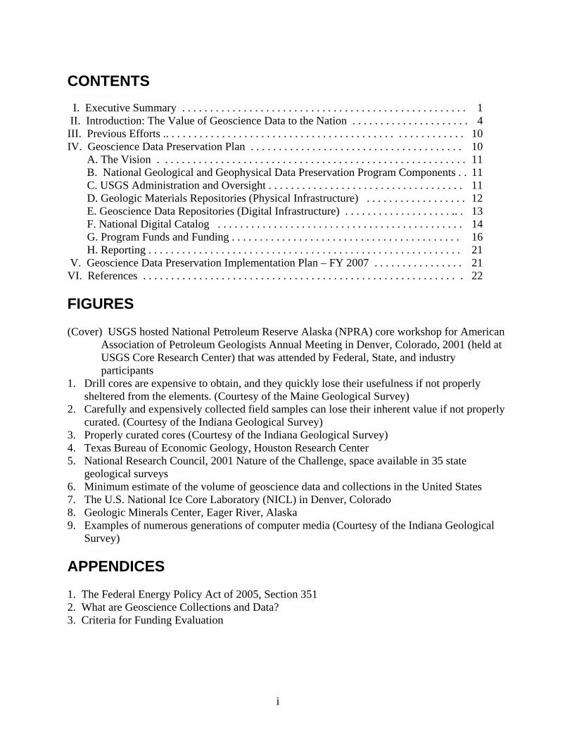
Implementation Plan for the National Geological and Geophysical Data Preservation Program
by the Data Preservation Working Group of the National Cooperative Geologic Mapping Program Federal Advisory Committee
October 10, 2006
CONTENTS I. Executive Summary . . . . . . . . . . . . . . . . . . . . . . . . . . . . . . . . . . . . . . . . . . . . . . . . . . . 1 II. Introduction: The Value of Geoscience Data to the Nation . . . . . . . . . . . . . . . . . . . . . 4 III. Previous Efforts .. . . . . . . . . . . . . . . . . . . . . . . . . . . . . . . . . . . . . . . . . . . . . . . . . . . . . 10 IV. Geoscience Data Preservation Plan . . . . . . . . . . . . . . . . . . . . . . . . . . . . . . . . . . . . . . 10
A. The Vision . . . . . . . . . . . . . . . . . . . . . . . . . . . . . . . . . . . . . . . . . . . . . . . . . . . . . . . 11 B. National Geological and Geophysical Data Preservation Program Components . . 11 C. USGS Administration and Oversight . . . . . . . . . . . . . . . . . . . . . . . . . . . . . . . . . . . 11 D. Geologic Materials Repositories (Physical Infrastructure) . . . . . . . . . . . . . . . . . . 12 E. Geoscience Data Repositories (Digital Infrastructure) . . . . . . . . . . . . . . . . . . . .. . 13 F. National Digital Catalog . . . . . . . . . . . . . . . . . . . . . . . . . . . . . . . . . . . . . . . . . . . . 14 G. Program Funds and Funding . . . . . . . . . . . . . . . . . . . . . . . . . . . . . . . . . . . . . . . . . 16 H. Reporting . . . . . . . . . . . . . . . . . . . . . . . . . . . . . . . . . . . . . . . . . . . . . . . . . . . . . . . . 21
V. Geoscience Data Preservation Implementation Plan – FY 2007 . . . . . . . . . . . . . . . . 21 VI. References . . . . . . . . . . . . . . . . . . . . . . . . . . . . . . . . . . . . . . . . . . . . . . . . . . . . . . . . . 22
FIGURES
(Cover) USGS hosted National Petroleum Reserve Alaska (NPRA) core workshop for American Association of Petroleum Geologists Annual Meeting in Denver, Colorado, 2001 (held at USGS Core Research Center) that was attended by Federal, State, and industry participants
1. Drill cores are expensive to obtain, and they quickly lose their usefulness if not properly sheltered from the elements. (Courtesy of the Maine Geological Survey)
2. Carefully and expensively collected field samples can lose their inherent value if not properly curated. (Courtesy of the Indiana Geological Survey)
3. Properly curated cores (Courtesy of the Indiana Geological Survey) 4. Texas Bureau of Economic Geology, Houston Research Center 5. National Research Council, 2001 Nature of the Challenge, space available in 35 state
geological surveys 6. Minimum estimate of the volume of geoscience data and collections in the United States 7. The U.S. National Ice Core Laboratory (NICL) in Denver, Colorado 8. Geologic Minerals Center, Eager River, Alaska 9. Examples of numerous generations of computer media (Courtesy of the Indiana Geological
Survey)
APPENDICES
1. The Federal Energy Policy Act of 2005, Section 351 2. What are Geoscience Collections and Data? 3. Criteria for Funding Evaluation
i
Implementation Plan for the National Geological and Geophysical Data Preservation Program
I. EXECUTIVE SUMMARY
With the passage of the Energy Policy Act of 2005 and potential future funding for activities in the act there exists an unprecedented opportunity to inventory, archive, and preserve geologic and geophysical data collected by numerous organizations for the past 150 years. Section 351 of the Energy Policy Act directs the Secretary of the Interior, through the Director of the U.S. Geological Survey (USGS), “to carry out a National Geological and Geophysical Data Preservation Program” which is comprised of “State agencies that elect to be part of the system and agencies within the Department of the Interior that maintain geological and geophysical data and samples.” Section 351 also states that “the Secretary may not designate a State agency as a component of the data archive system unless that agency is the agency that acts as the geological survey in the State.”
A. The Vision
The USGS envisions a national network of cooperating geoscience materials and data repositories that are operated independently yet guided by common standards, procedures, and protocols for metadata. The holdings of all collections will be widely accessible through a common and mirrored Internet-based catalog, the National Digital Catalog. The holdings of the individual repositories will complement each other to preserve the geoscience assets of the Nation and serve as a comprehensive source of geoscience data and materials to serve national needs today and in the future.
B. The Purpose
The purpose of geological and geophysical data preservation is clear—to preserve and provide access to samples (and any related data) that have been extracted from the Earth to improve the breadth of information that can be used to inform science and decision making now and in the future. Federal and State agencies have made substantial efforts over the decades to collect and save such materials. Even though only a small fraction of all the data acquired over the past 150 years have been saved, this nonetheless represents a huge volume of information and a remarkable legacy for the future.
C. Implementation Recommendations for the USGS
• Administer the new National Geological and Geophysical Data Preservation Program (NGGDPP).
• Coordinate geologic materials repositories and data archives through a data preservation system.
o The physical infrastructure will include geologic materials repositories. o The digital infrastructure will consist of geologic data repositories and standardized
catalogs.
1
o These facilities and collections will be managed by agencies within the Department of the Interior (DOI) and State geological surveys.
o Each repository will establish an advisory committee to develop procedures and protocols appropriate for that facility yet consistent with the national standards.
• Establish and maintain a National Digital Catalog. o This catalog will identify data and samples available in the data archive system, the
repository for particular geologic data and collections in the system, and the means of accessing the material.
o Minimal metadata will be required for inclusion in the National Digital Catalog in order to maximize participation. Federal funding support will require local adherence to national standards.
o Inventory and catalog the data in a uniform manner and provide metadata to that information in an easily accessible, digital format through the National Digital Catalog that will allow users to quickly determine what is available and where it is located.
o Provide consistent standards for the preservation, curation, and access to all geological and geophysical holdings.
• Establish a program of technical and financial assistance to fulfill the requirements authorized in the act.
o Financial assistance will be awarded annually on a competitive basis following the evaluation and ranking of both Federal and State proposals by a review panel composed of representatives from DOI, State geological surveys, academic institutions, and the private sector.
o Proposals may be submitted by any DOI agency or State agency with geologic data or collections or by some combination of eligible Federal and State agencies.
o Partnerships with universities and private industry will be encouraged in order to seek contributions from all available resources.
o Requests for funding will be evaluated based on a comprehensive proposal and business plan that will address a number of elements to ensure the program’s success.
o Once a Federal agency or State geological survey has received funding from the NGGDPP, they must be in compliance with program requirements and have no outstanding deliverables (performance reports) to apply for additional funding.
o In order to gain the greatest leverage of limited Federal and State funds, each proposed State-originated program must show a 1:1 Federal/State match of direct-cost dollars.
o It is anticipated that most awards will fall into four general categories: physical infrastructure, digital infrastructure, outreach and application, and special needs.
• Maintain and improve repositories for physical holdings (cores, cuttings, minerals, fossils) across the Nation that allow public access to those materials that are critical for present and future exploration of natural resources, protection of the environment, and mitigation of natural hazards.
• Establish working groups, as needed, through the National Cooperative Geologic Mapping Program—Federal Advisory Committee (NCGMP-FAC) to provide
o Expert advice on the types of samples and data to be preserved and the priority of their accession,
o Recommendations for proper preservation of physical samples and digital data,
2
o Training and technology transfer protocols for inventorying and archiving of geological materials, and
o Performance measures to ensure the success and effectiveness of the entire program. Performance measures will include progress toward or completion of stated goals.
D. FY 2007 Implementation Plan
In Fiscal Year (FY) 2007, using funds allocated for the USGS NGGDPP, the new Program Coordinator on the Chief Scientist for Geology staff will begin implementation of the program. When appropriate, a working group of the NCGMP-FAC will be established to provide expert advice. The following actions are planned: • Transfer approximately 1,000 pallets of important oil shale cores, currently inaccessible and
stored in the Anvil Mine, west of Denver, Colorado, to the USGS core repository at the Denver Federal Center. Curate this material and make it available to researchers within the Federal Government, States, universities, and private industry.
• Expand the effort to preserve and make accessible on-line the extensive offshore seismic reflection data along the west coast of the United States that was donated by private industry.
• Begin interactions with State geological surveys and other DOI agencies that maintain geological and geophysical data and samples to address their preservation and data rescue needs.
• Initiate curation of critical paleontologic and other energy-related collections. • Establish the program’s peer review panel. • Establish detailed guidelines for distribution of program funds. • Establish spending priorities for the first 3 years of the program. • Establish minimum standards and best practices for the preservation and archiving of the
various geologic data and collections, including consistent inventory standards where appropriate. Establish guidelines for the proper preservation of physical samples, as well as original data and derived information stored on various paper and digital media. Coordinate efforts with other organizations that are dedicated to the exchange of information in the geosciences.
• Design and begin initial implementation of a national data archive (National Digital Catalog) of geologic and geophysical information, including maps, well logs, engineering data and samples. Establish guidelines for standardized data catalogs and directories that follow national and international standards. Establish metadata standards for all data to be incorporated within the National Digital Catalog.
• Establish guidelines for data migration so data are not lost due to recording media degradation or changing data recording formats and programs.
• Prepare an annual report for the Secretary of the DOI on the progress of implementing the program.
3
II. INTRODUCTION: THE VALUE OF GEOSCIENCE DATA TO THE NATION
A. Acknowledgments
The USGS recognizes the importance of geoscience data preservation for the Nation and wishes to thank those members of the U.S. scientific community who assisted in the development of this report. We especially thank the Association of American State Geologists, the USGS NCGMP-FAC, and the Data Preservation Working Group of the NCGMP-FAC.
1. NCGMP-FAC Working Group Members
John C. Steinmetz, Chair, Director and State Geologist, Indiana Geological SurveyEdith Allison, Exploration Program Manager, Office of Natural Gas and Petroleum Technology, U. S. Department of Energy Odin Christensen, Newmont Mining, Mancos, Colorado Beverly DeJarnett, Research Associate/Curator, Texas Bureau of Economic Geology, Houston Research
Center William B. Harrison, III, Director, Michigan Basin Core Research Laboratory, Department of Geosciences, Western Michigan University Christopher Keane, Director, Technology & Communications, American Geological Institute (AGI) H. Richard Lane, Program Director, Sedimentary Geology and Paleobiology, National Science
Foundation Gary L. Lore, Chief, Resource Evaluation Division, Minerals Management Service Peter T. Lyttle, Program Coordinator, National Cooperative Geologic Mapping and Landslide Hazards Programs, U.S. Geological Survey Brenda S. Pierce, Program Coordinator, Energy Resources Program, USGS James M. Robertson, Director and State Geologist, Wisconsin Geological and Natural History Survey Peter A. Scholle, Director and State Geologist, New Mexico Bureau of Geology & Mineral Resources, Association of American State Geologists (AASG) President
2. NCGMP-FAC Participants
Linda C. Gundersen, FACA Chair, Acting Associate Director for Geology, USGS A. Roger Anzzolin, U.S. Environmental Protection Agency Laurel M. Bybell, Associate Program Coordinator, NCGMP, USGS Carla Kertis, U.S. Department of Agriculture, Natural Resources Conservation Service Peter T. Lyttle, Program Coordinator, NCGMP and Landslide Hazards Program, USGS Randall C. Orndorff, Associate Program Coordinator, NCGMP, USGS Jonathan G. Price, Nevada State Geologist, Nevada Bureau of Mines and Geology James M. Robertson, Wisconsin State Geologist, Wisconsin Geological Survey Robert J. Silva, Program Analyst, Office of Natural Gas & Petroleum, U.S. Department of Energy Robert E. Smith, U.S. Environmental Protection Agency William J. Siok, Executive Director, American Institute of Professional Geologists Gene Whitney, Office of Science and Technology Policy
4
B. Purpose and Scope
With the passage of the Energy Policy Act of 2005, and potential future funding for activities in the Act, there now exists an unprecedented opportunity to Definitions and naming conventions
utilized in this report: inventory, archive, and preserve geologic and geophysical data collected by numerous NGGDPP Act = “National Geological and organizations for the past 150 years. These data are Geophysical Data Preservation Program Act irreplaceable, are critical to the future understanding of 2005.” Energy Policy Act of 2005, Public
of our Nation’s resources, and represent a geologic Law 109-58, Sec. 351. (Appendix 1)
treasure for future generations. Section 351 of the Geologic data and collections = includes Energy Policy Act directs the Secretary of the surface and subsurface geologic, Interior, through the Director of the USGS, “to carry geophysical, and engineering data, maps, out a National Geological and Geophysical Data well logs, and samples that are contained in
Preservation Program” (Appendix 1). The Act sample sets, collections, or in various media.
authorizes the appropriation of $30,000,000 for each The terms “geological materials centers” and of the fiscal years 2006 through 2010 to carry out “repositories” can be used interchangeably. this program. This report to Congress explains the first steps for implementing such a program.
The past century-and-a-half of America’s industrial development has seen the extraction of natural resource wealth from our lands. The exploration for and production of oil, gas, coal, metallic and industrial minerals, and other commodities were accomplished by drillingboreholes, acquiring vast amounts of geophysical data, and sampling extensive numbers of surface rock exposures, many of which are no longer accessible. These geoscience collections and related data constitute a variety of information and materials (Appendix 2). These include collections of physical Earth materials (rocks, soils, fluids, minerals, fossils), digital data collected from the Earth (seismic data, chemical data, well log data), and conventional library collections (books, journals, maps, charts).
These materials and related data are invaluable. In many instances, the material and data are irreplaceable due to destruction of outcrops, urbanization, and restricted access. These materials represent our primary source of information on the subsurface geology of our Nation and the scientific understanding of our natural resources and natural hazards. Most importantly, future use of both the materials and related data will certainly provide future economic benefits.
The Administration recently recognized the value of scientific collections in its annual memorandum of June 23, 2006, to all Federal departments and agencies outlining the Administration's research and development priorities for FY 2008. The memo includes the following passage. “Agencies should assess the priorities for and stewardship of Federal scientific collections, which play an important role in public health and safety, homeland security, trade and economic development, medical research, and environmental monitoring. Agencies should develop a coordinated strategic plan to identify, maintain, and use Federal collections and to further collections research.” This preservation plan supports those Administration goals.
5
Some recent examples of the value of the preservation of primary data and geologic materials include:
• CO2 sequestration, where we now are testing core samples from old oilfields to see how they will react to the high-pressure injection of carbon dioxide.
• Reworking of old oilfields with new technologies such as horizontal drilling in which cores, cuttings, and geophysical logs from old vertical wells are reexamined to determine optimal horizons for new drilling.
• Discoveries of bypassed oil or gas that went unrecognized during original exploration are being made, often by small producers, through careful reexamination of cores, cuttings, and logs from the original wells. For example, more than 10 percent of New Mexico’s oil production in the mid-1990s came from such reworking of a single oilfield (Dagger Draw).
• Technological developments and rising oil and gas prices have allowed for the economic development of much smaller fields than in the past. By reexamining archival data, land management agencies and exploration companies alike can determine where such accumulations might exist.
• Discoveries of new metal deposits in areas long mined for other metals are being made because what is economic today was not always economic in the past. Reexamination and reanalysis of old samples commonly discloses now-valuable concentrations of metals that, in some cases, were never analyzed. For example, the current upsurge in demand for uranium has led to a commensurate surge in price and thus created demand for new exploration. That, in turn, has led to a desire to reexamine information from the last exploration cycle (1950-1980).
• Scarcity of water resources is a significant natural resource concern in many areas of the U.S. Stored cores, fluid samples, and log data from old energy wells are providing the ability to predict the volumes and quality of deep subsurface waters that may be amenable to desalination.
• Glacial ice cores preserve an objective record of the Earth’s atmosphere and climate for the past thousands of years, providing critical data to answer questions regarding climate change.
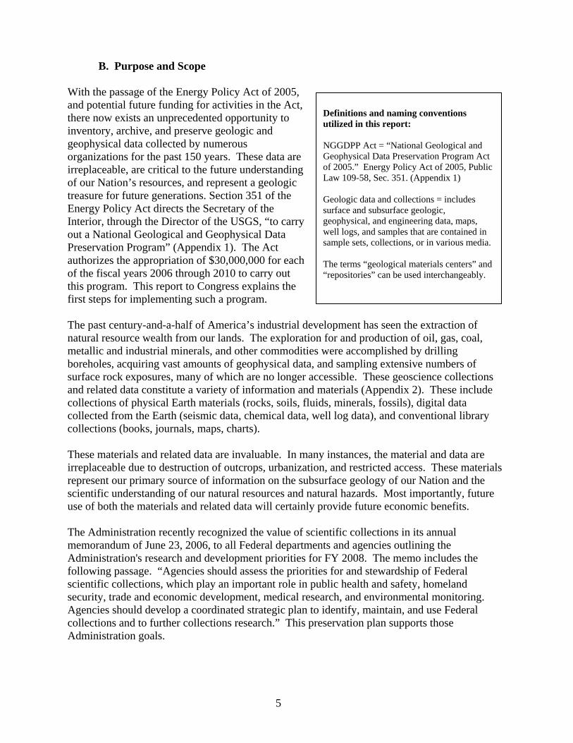
The need to preserve, catalog, and increase access to these materials reflects their recognized future economic importance. Geological and geophysical data preservation will provide current and future generations the ability to examine samples that have been extracted from the Earth over the past 150 years and will allow for the benefits of that legacy to continue. Organizations that currently store geological data and materials include the various Federal scientific and land management agencies, State geological surveys and other State agencies, universities, museums, and private companies. The urgency associated with saving these materials is due to the inadequate, incomplete, and uncoordinated efforts currently being used to preserve many of these data and materials (Figures 1-2).
6
Figure 1 – Drill cores are expensive to obtain, and they – quickly lose their usefulness if not properly sheltered from the elements. (Courtesy of the Maine Geological Survey)
Figure 2 – Carefully and expensively collected field samples can lose their inherent value if not properly curated in appropriate containers with adequate metadata and with sufficient cataloging that will allow for their access and retrieval and long-term preservation. (Courtesy of the Indiana Geological Survey)
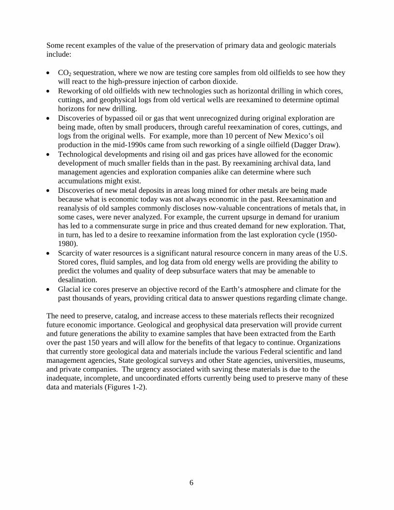
Geoscience data preservation in the United States currently includes a set of disparate facilities and programs. Some repositories are secure and well-managed to ensure long-term preservation of materials (Figure 3). These include the University of Texas at Austin Bureau of Economic Geology (http://www.beg.utexas.edu/crc/index-crc.htm) (Figure 4) and the U.S. National Ice Core Laboratory, USGS, Denver, Colorado (http://nicl.usgs.gov/index.html). Other facilities are barely a shelter for their holdings. Some collections are well cataloged and have been converted to digital information available on the Web or via electronic media. The AKGeology.info Web site for Alaskan geoscience data is an example of an excellent data recovery, preservation, and delivery program (http://maps.akgeology.info/).
Figure 3 – Properly curated cores ensure their ease of retrieval and use and provide for their long-term preservation. (Courtesy of the Indiana Geological Survey)
Figure 4 – Two views of the Bureau of Economic Geology Research Center in
Houston, TX.
7

Other collections have never been cataloged or have only paper records. Only a small fraction of the Nation’s holdings are coordinated, leaving potential users with the daunting task of having to search in many places for often poorly cataloged or poorly accessible information or samples. There is currently no Nation-wide coordination and no national standards for geoscience data preservation.
Bureau of Economic Geology Core Nature of the Challenge Research Centers, University of Texas
Space Available in 35 State Geological Surveys at Austin
In addition to being a research unit of The University of Texas at Austin, the Bureau
>40% SA of Economic Geology (BEG) serves the 31-40% SA
6 6 0% Space Available (SA)
26
21-30% SA 14
11-20% SA 1-5% SA 11 14
23
6-10% SA
Figure 5 – Pie chart showing percent of 35 state geological surveys that have each of the 7 available space categories. SA = space available in a repository. NRC (2002)
State of Texas as the Texas Geological Survey. In this role, BEG maintains a variety of public resources and facilities, including the three Core Research Centers (CRC), a geoscience and engineering technical library, and the Geophysical Log Facility. These facilities are open to the public Monday through Friday from 8:00 a.m. to 5:00 p.m. BEG has maintained a collection of core and well cuttings since the 1930s. The current Core Research Centers, all state-of-the-art facilities, now store more than 1.7 million items of geologic material, including core, cuttings, outcrop samples, thin sections, and paleontologic and geochemical samples. BEG’s holdings constitute one of the largest public collections of subsurface geologic materials in the world.
Minerals Data Information Rescue in Alaska
The Web site http://www.akgeology.info/ is a portal for geoscientific and mineral resources information for Alaska, bringing together data from multiple State and Federal agencies. This Web site is the culmination of the federally funded Minerals Data and Information Rescue for Alaska (MDIRA) program, a 5-year program mandated by Congress in 1998 and managed by the U.S. Bureau of Land Management and the USGS. The program goals—to recover and renew legacy publications, data, and geological materials in Alaska and to develop information management systems to deliver information from multiple sources through a single Web portal—have been achieved. A wealth of geoscience data, much of it nearly lost to public access, is readily available to any visitor to this “one-stop” Web site. This site stands as a model for other geoscience data archival and retrieval systems.
Even though we are storing only a small fraction of all the materials and data acquired over the past 150 years, they still represent a huge volume of information and a remarkable legacy for the future. However, more than 25 percent of the Nation’s geological data repositories in 35 States are at or near their storage capacity (Figure 5, from National Research Council, 2002). Much of the material considered under this legislation, including rock samples, cores, and bagged chips or cuttings taken from wells, is both heavy and volumetrically large (Figure 6) and requires specialized storage facilities. Some of these collections, like ice cores (Figure 7), require even more specific and expensive storage facilities. One might wonder if it would be preferable to just
8
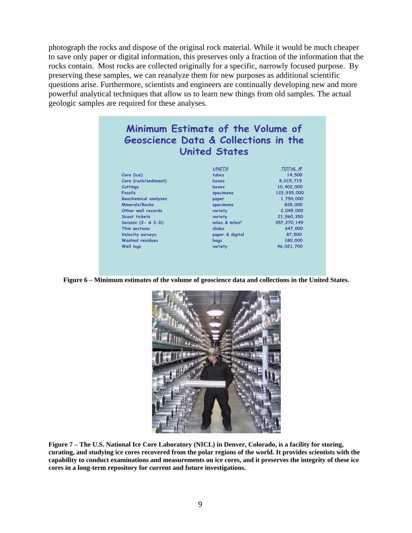
photograph the rocks and dispose of the original rock material. While it would be much cheaper to save only paper or digital information, this preserves only a fraction of the information that the rocks contain. Most rocks are collected originally for a specific, narrowly focused purpose. By preserving these samples, we can reanalyze them for new purposes as additional scientific questions arise. Furthermore, scientists and engineers are continually developing new and more powerful analytical techniques that allow us to learn new things from old samples. The actual geologic samples are required for these analyses.
Minimum Estimate of the Volume ofGeoscience Data & Collections in the
United States
UNITS TOTAL # Core (ice) tubes 14,500 Core (rock/sediment) boxes 8,015,715 Cuttings boxes 10,402,000 Fossils specimens 122,935,000 Geochemical analyses paper 1,750,000 Minerals/Rocks specimens 828,000 Other well records variety 2,045,000 Scout tickets variety 21,960,350 Seismic (2- & 3-D) miles & miles2 357,270,149 Thin sections slides 647,000 Velocity surveys paper & digital 87,500 Washed residues bags 180,000 Well logs variety 46,021,700
Figure 6 – Minimum estimates of the volume of geoscience data and collections in the United States.
Figure 7 – The U.S. National Ice Core Laboratory (NICL) in Denver, Colorado, is a facility for storing, curating, and studying ice cores recovered from the polar regions of the world. It provides scientists with the capability to conduct examinations and measurements on ice cores, and it preserves the integrity of these ice cores in a long-term repository for current and future investigations.
9
In addition, our understanding of geological processes and how we interpret the rock record changes over time, sometimes significantly. For example, the evolution of the concept of sequence stratigraphy, which was developed in the late twentieth century, fundamentally changed how geoscientists interpret the rock record and ultimately predict the occurrence of oil and gas reservoirs. Many previously undiscovered accumulations were found and developed using sequence stratigraphy.
III. PREVIOUS EFFORTS
After examining the status of the Nation’s geoscience data and collections, the National Research Council (NRC) published a report in 2002, entitled “Geoscience Data and Collections – National Resources in Peril” (NRC, 2002), and the American Geological Institute (AGI) published a study in 2003, entitled “National Geosciences Data Repository System: Phase III: Implementation and Operation of the Repository: Final Report” (AGI, 2003). In these reports, the NRC and AGI explore the need for data preservation, current efforts by various organizations, and cost benefit analyses.
In 1994, the AGI initiated its Department of Energy-funded National Geoscience Data Repository System (NGDRS) project with the goal of identifying how at-risk geoscience data can have their full residual value realized and be preserved. The most publicly visible result of the nine years of the NGDRS project was development of the GeoTrek metadata catalog system.
The USGS will consider the recommendations and lessons learned from these reports and activities and other existing efforts dealing with geoscience data preservation.
IV. GEOSCIENCE DATA PRESERVATION PLAN
Geoscience data preservation involves a number of steps: (1) develop protocols to evaluate what geological materials and data are kept, acquired, assimilated, or discarded; (2) establish a system to organize the physical samples, data, and metadata; (3) provide appropriate repositories for these materials; (4) make users aware of these geoscience data and collections and provide access; and (5) ensure that samples and data continue to be useful and reliable. A successful strategy for managing geoscience data and collections in the United States must address all of these components.
What are Metadata?
Metadata are information about data and/or geospatial services, such as content, source, vintage, spatial scale, accuracy, projection, responsible party, contact phone number, method of collection, and other descriptions. Metadata are critical to document, preserve, and protect agencies' spatial data assets. Reliable metadata, structured in a standardized manner, are essential to ensuring that geospatial data are used appropriately and that any resulting analysis is credible. Metadata also can be used to facilitate the search and access of data sets or geospatial services within a clearinghouse or data library. All spatial data collected or derived directly or indirectly using Federal funds will have Federal Geographic Data Committee metadata.
Office of Management and Budget, 2002
10
A. The Vision
The USGS envisions a national network of cooperating geoscience materials data repositories that are operated independently yet guided by common standards, procedures, and protocols for metadata. Data will be archived according to accepted national and international formats and standards. To ensure this, a set of national standards will be developed and which must be followed to obtain Federal financial assistance. The holdings of all collections will be widely accessible through a common and mirrored Internet-based catalog, the National Digital Catalog. The holdings of the individual repositories will complement each other to preserve the geoscience assets of the Nation and serve as a comprehensive source of geoscience data and materials to serve national needs today and in the future.
B. National Geological and Geophysical Data Preservation Program Components
The Federal Component applies to Federal agencies within the Department of the Interior that collect and maintain geological and geophysical data and samples requiring archival preservation. The objective of this component is to properly archive, preserve, and make available for use geologic data and collections under Federal purview that are determined to be vital to the economic, social, environmental, or scientific welfare of the United States.
The State Component includes State geological surveys (or those State agencies that serve as State geological surveys) that collect and maintain geological and geophysical data and samples requiring archival preservation. The objective of this component is to properly archive, preserve, and make available for use geologic data and collections under State purview that are determined to be vital to the economic, social, environmental, and/or scientific welfare of the United States. This Program is restricted to State agencies in accordance with section 351 of the Energy Policy Act, which limits participation in this data archive system to “the agency that acts as the geological survey in the State.”
C. USGS Administration and Oversight
In accordance with the NGGDPP Act, the USGS will administer the NGGDPP. The NCGMP-FAC will advise the USGS on planning and implementation of the NGGDPP (Figure 2). Toward that end, the NCGMP-FAC will establish, as needed, various working groups to provide expert advice.
1. With appropriations received for this program, the USGS will oversee the preservation of geologic, geophysical, and engineering data, maps, well logs, and samples in a disseminated data preservation system that provides storage, preservation, and archiving capabilities.
The data preservation system will consist of two parts:
• Physical infrastructure, which will include the geologic materials repositories.
11
• Digital infrastructure, which will consist of geologic data repositories and standardized catalogs. These facilities and collections will be managed by agencies within the DOI and State geological surveys.
The system also will provide for the archiving of relevant geologic data and collections obtained from Federal lands. These data and collections will be archived in the most appropriate repository, with preference being given to archiving data in the State in which the data were collected.
To ensure ready access to the data and collections, the program, with advice from the NCGMP-FAC, will establish minimum standards, best practices, and performance measures for the preservation and archiving of the various geologic data and collections, and will establish consistent inventory standards and formats. In addition, the program will make recommendations for the proper preservation of physical samples as well as original data and derived information stored on various paper and digital media (for example, paper logs, maps, digital tapes, and other magnetic media).
2. The USGS will establish a National Digital Catalog of archived material.
Using funding appropriate for this program, the USGS will administer the operation of the National Digital Catalog. The National Digital Catalog identifies:
• Data and samples available in the data archive system; • The repository for particular geologic data and collections in the system; and • The means of accessing the material.
The National Digital Catalog is a Web portal to the various databases. The National Digital Catalog will contain sufficient metadata to allow the user to identify and locate data and collections of interest that are maintained in their respective Federal or State agencies.
3. The USGS will provide financial assistance related to the archived material.
Following established guidelines, the USGS will implement a competitive process to distribute funds. After submission, all Federal and State proposals will be reviewed by a peer review panel that will have Federal, State, and external members. Using advice from the panel, the NGGDPP will provide funding to projects. States must be able to provide funding equal to or greater than that received from the NGGDPP.
D. Geologic Materials Repositories (Physical Infrastructure)
The national geologic collection will consist of the aggregate network of distributed cooperating Federal and State geologic materials repositories that are maintained by USGS, Minerals Management Service, Bureau of Land Management, and other DOI agencies, and the geologic data and collections repositories maintained by State geological surveys.
12
Geologic materials are, by their very origin, place-based and are best interpreted in their local geologic context and most likely to be used near their place of origin. In general, State geologic repositories will archive samples acquired within the State. The USGS repositories will archive unique sample types (for example, ice cores), samples from specific USGS programs, and materials of national interest.
Thus, each geologic repository will have unique holdings and, in the case of the States, will reflect the geologic opportunities and challenges of that region. Each repository or State will establish its own Science Advisory Panel to establish accession/deaccession criteria and priorities, operational procedures, and business oversight consistent with the national standards.
The NGGDPP will work to improve the capacity and effectiveness of the data preservation system by enabling improvements to the individual repositories. This includes:
• Increasing Capacity. Many geologic materials repositories in the United States are near-full, full, or overfull. There is an urgent need to add physical collection and storage processing capacity through better shelving and new repository facilities.
• Improving Operations. The USGS through a working group will establish minimum preservation and curation standards and “best practices” to be followed by all participating repositories.
• Providing Accessibility. Collections are valuable only if the holdings are organized, cataloged, identifiable as to location sampled, sampling or analytical technique known and documented, accessible, and retrievable for study and use. Common standards for the maintenance and format for catalogs and metadata will permit integration of the participating collections into a national geoscience data and collections catalog.
E. Geoscience Data Repositories (Digital Infrastructure)
The national geoscience data archive similarly consists of the distributed collections of various Federal and State data archives. The objective of this program is to protect these data and make them readily available for a variety of needs.
A working group of the NCGMP-FAC will develop guidelines for standardized data catalogs and directories that follow national and international standards. Using the national standards for metadata also will be an important component of this system. This effort will be coordinated with specialists from information societies and other organizations that are dedicated to the exchange of information in the geosciences through cooperation among scientists, librarians, editors, cartographers, educators, and information specialists.
This working group will establish guidelines for data migration. Data migration is the continuing process of assuring that data are not lost due to recording media degradation or changing data recording formats and programs.
13
F. National Digital Catalog
A National Digital Catalog will be a fully-distributed system with a primary Web portal for locating publicly available Federal and State geoscience data from anywhere in the United States. Many of these data will be available to be transmitted digitally via the Internet. In addition, the mirrored distributed nature of the National Digital Catalog will ensure that the data are always accessible should one of the Internet sites temporarily fail.
The National Digital Catalog will be designed to handle efficiently any expected queries by professional geoscientists. For example, a user will be able to query across multiple locations for a particular piece of information. The user can then query from this data set for particular data and information types.
1. Challenges
One of the greatest challenges to establishing the National Digital Catalog is connecting the diverse and numerous geoscience and geophysical data repositories in the United States, which together represent the collections of our Nation’s geoscience heritage. With such a disparate suite of organizations, data management styles, and unique collections come a number of challenges that the catalog must address to maximize utility, and thus value, to the public.
Each participating geologic repository is independent with unique charges, responsibilities, and holdings, and its operational framework will need to be respected. The diversity and level of sophistication of repositories’ local catalogs varies widely, from world-class digital data archives to paper index cards (AGI, 2003). The National Digital Catalog will need to provide integrated access to the entire distributed holdings of all the participating repositories, but at the same time preserve their unique presence and “storefront” to the public.
Most searches in the National Digital Catalog will be expected to be geography-based (i.e., keyed to spatial coordinates) with key geologic constraints. Geology does not recognize political boundaries, and in many cases, geographic searches will need to access multiple geoscience repositories.
2. Implementing a Successful National Digital Catalog
a. Basic Function
Access to the National Digital Catalog will be through the Internet via a primary USGS Web site and through the search capabilities of participating repositories. This access will be consistent with all applicable requirements related to confidentiality and proprietary data.
The vision of a one-stop Web portal for locating geoscience data and collections is the primary driver for a National Digital Catalog. The catalog itself will not hold or manage the actual geoscience data, but rather will provide metadata—data about data—to facilitate rapid search and location of interlinked geoscience data resources.
14
The portal interface will provide a geospatially-enabled interface for searching and locating both the geographic location where the data were derived, for finding where the materials are held, and the pertinent information required to allow the end-user access to the data. This approach would allow for a public “one-stop-shop” approach to accessing a currently disparate national resource.
From the perspective of the participating repositories, particularly well-established repositories, the system will be nonintrusive and provide added value to their operations. Intrinsically, greater exposure of the data represents a substantial added value for most repositories—fundamentally increasing the measurable and scientific value of their holdings. Many repositories have substantial information technology investments already in place in their systems, databases, applications, and data models.
b. Standards
To ensure interoperability among repositories, it is important to establish standards for metadata presented in the National Digital Catalog. All data indexed within the National Digital Catalog will be required to meet a minimum level of indexing quality before incorporation. Minimal metadata will include location in geographic coordinates, type of information or sample (from a dropdown list similar to information shown in Appendix 2), and where the information and materials reside. Internet links to geologic data and collections contributed to the national system of archives will have format, symbols, and technical attributes that adhere to nationally recognized standards so that archival information can be accessed, exchanged, and compared efficiently and accurately.
c. Interconnectedness
By design, the National Digital Catalog will represent a network-centric data search and retrieval resource. Thus, a challenge for the National Digital Catalog will be the initial engagement of a wide range of repositories to ensure that the system can deliver the maximum flexibility needed for both the end-user and the participating repositories. The range of geological and geophysical data and collections available through the National Digital Catalog will be diverse, and it will be important to work with repositories when setting up connections.
d. Participation
All agencies within DOI and State agencies that maintain geological and geophysical data and samples will be encouraged to participate in the National Digital Catalog. Other repositories can be added as time and funds allow.
15
G. Program Funds and Funding
1. Use of Funds
a. Administration of the NGGDPP
Using additional future funding that may be appropriated specifically for this program, the USGS will manage the program to ensure the fair distribution of the funds into component shares. Component shares will be allocated as indicated below, unless otherwise indicated by Congress.
b. Component shares
Federal Component share – The Federal share of the cost of activities under the Federal component for any fiscal year will not exceed one-third (33 1/3 percent) of the Federally appropriated funds made available for any fiscal year. Activities will include the administration of the program, the operation of the National Digital Catalog, and the Federal share of awards for Federal projects. The State and Federal components will share development of the catalog.
State component share – The State share of the cost of activities under the State component for any fiscal year will be the remainder of the Federally appropriated funds, dependent upon the States providing matching funds, and they will not be less than two-thirds (66 2/3 percent) made available for any fiscal year.
2. Applying for Funds
Financial assistance will be awarded annually on a competitive basis following the evaluation and ranking of proposals by a peer review panel. The USGS will engage a working group under the NCGMP-FAC to determine the process and criteria for the financial assistance.
3. Program Proposals
Proposals will be accepted and evaluated for both the Federal and State components once each Federal fiscal year. Proposals may be submitted by individual, eligible Federal or State agencies, or by a partnership combination of eligible Federal and State agencies.
Salaries and wages will be allowed that support program personnel. Supplies and capital equipment acquisition will be allowed.
Requests for funding will be evaluated based on a comprehensive proposal and business plan that will address a number of elements to ensure the program’s success (See Appendix 3).
4. Peer Review Panel
A peer review panel will be formed that consists of 10 members: four Federal, four State, and two external representatives. The Federal representatives will include two USGS members, one
16
of whom will serve as panel chair, and one each from Bureau of Land Management and Minerals Management Service. The State representatives will include four State Geologists or their designees. There will be two external representatives who serve as subject matter experts – one from academia and one from the private sector.
To avoid any conflict of interest, no panelist will be able to vote on a proposal from his or her Federal agency or State geological survey or State agency. No panelist may participate in any discussion with other panel members involving a proposal from the panelist’s agency.
5. Matching Funds
The Federal share of the cost of any State-originated project shall not be more than 50 percent of the total cost of the activity. The State match may be either with their own resources, with other State agencies resources, or with private industry resources. All matching funds must be directed toward the proposed project.
The valuation of collections and data, and its acceptability when applied to meet the cost sharing (matching) requirement, must be appraised by an independent third party, certified in the State in which the organization is registered. The organization using collections or data valuation in the cost sharing requirement must pay for the appraisal of the holdings.
6. Maintenance of Existing Funds
Both Federal and State proposals must document a current commitment of institutional resources such that any new financial assistance would be “in addition to” existing resources already being applied to proposed data preservation activities. Neither Federal nor State agencies may use this program as an opportunity to reduce existing resources currently being applied to data preservation activities.
7. Indirect Charges
Indirect charges will be allowed in calculating total costs. Indirect charges for State proposals will not exceed 18 percent of direct program costs. Indirect charges may apply only to those direct cost items allowable under the negotiated cost rate agreement.
8. Award Categories
The working group identified four general categories of awards: physical infrastructure, digital infrastructure, outreach and application, and special needs. It is anticipated that most, but not necessarily all, awards will fall into one or more of these categories. New categories will be added as needed.
a. Physical Infrastructure Awards
Recent surveys demonstrate that the majority of the Federal and State geologic data and collections repositories have less than 10 percent of their space unfilled, even as additional
17
samples and data are accumulating and as private companies continue to relinquish their collections. Therefore, funds are needed for the expansion of storage facilities.
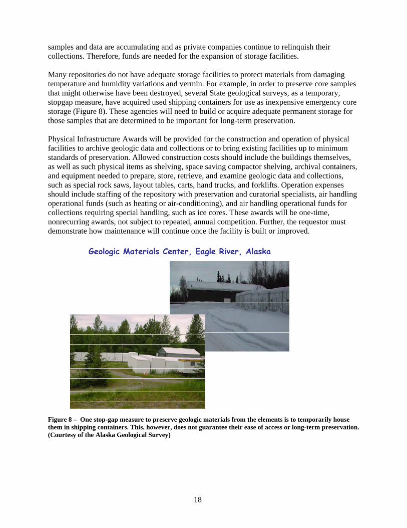
Many repositories do not have adequate storage facilities to protect materials from damaging temperature and humidity variations and vermin. For example, in order to preserve core samples that might otherwise have been destroyed, several State geological surveys, as a temporary, stopgap measure, have acquired used shipping containers for use as inexpensive emergency core storage (Figure 8). These agencies will need to build or acquire adequate permanent storage for those samples that are determined to be important for long-term preservation.
Physical Infrastructure Awards will be provided for the construction and operation of physical facilities to archive geologic data and collections or to bring existing facilities up to minimum standards of preservation. Allowed construction costs should include the buildings themselves, as well as such physical items as shelving, space saving compactor shelving, archival containers, and equipment needed to prepare, store, retrieve, and examine geologic data and collections, such as special rock saws, layout tables, carts, hand trucks, and forklifts. Operation expenses should include staffing of the repository with preservation and curatorial specialists, air handling operational funds (such as heating or air-conditioning), and air handling operational funds for collections requiring special handling, such as ice cores. These awards will be one-time, nonrecurring awards, not subject to repeated, annual competition. Further, the requestor must demonstrate how maintenance will continue once the facility is built or improved.
Geologic Materials Center, Eagle River, Alaska
Figure 8 – One stop-gap measure to preserve geologic materials from the elements is to temporarily house them in shipping containers. This, however, does not guarantee their ease of access or long-term preservation. (Courtesy of the Alaska Geological Survey)
18
b. Digital Infrastructure Awards
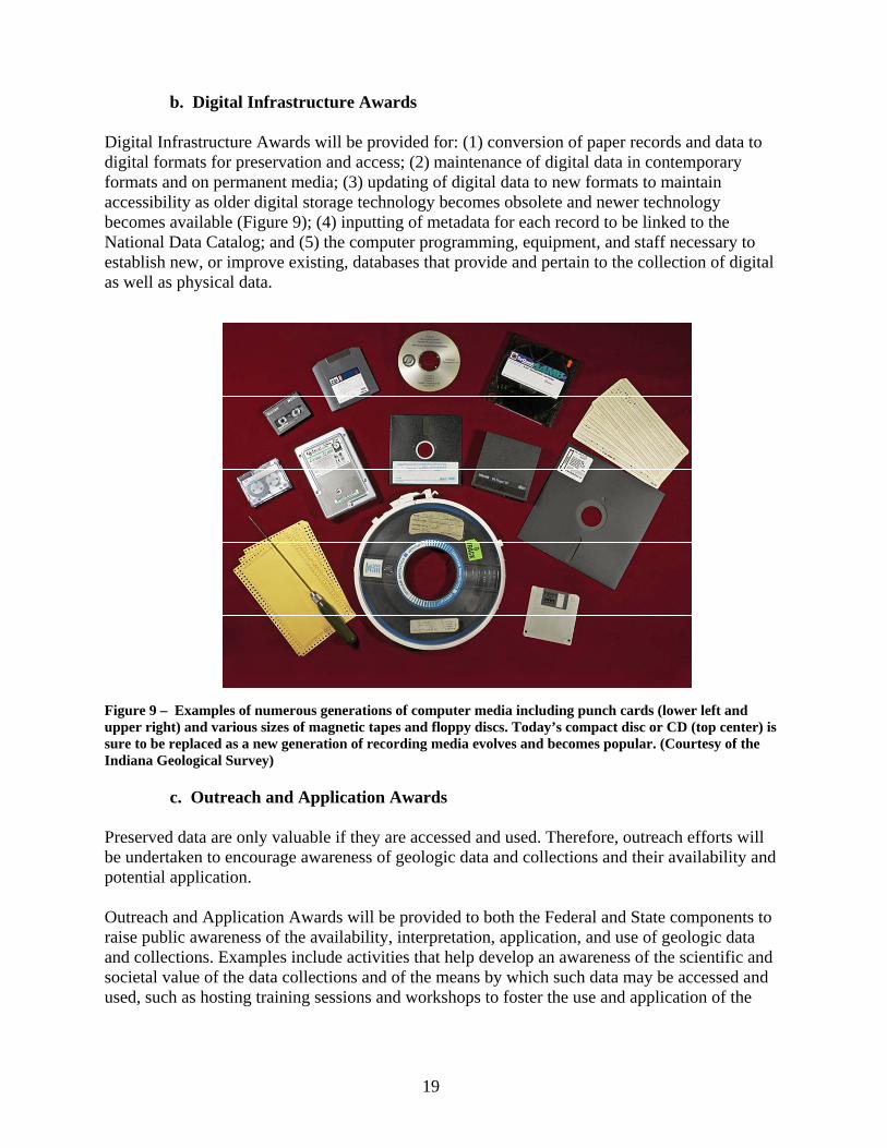
Digital Infrastructure Awards will be provided for: (1) conversion of paper records and data to digital formats for preservation and access; (2) maintenance of digital data in contemporary formats and on permanent media; (3) updating of digital data to new formats to maintain accessibility as older digital storage technology becomes obsolete and newer technology becomes available (Figure 9); (4) inputting of metadata for each record to be linked to the National Data Catalog; and (5) the computer programming, equipment, and staff necessary to establish new, or improve existing, databases that provide and pertain to the collection of digital as well as physical data.
Figure 9 – Examples of numerous generations of computer media including punch cards (lower left and upper right) and various sizes of magnetic tapes and floppy discs. Today’s compact disc or CD (top center) is sure to be replaced as a new generation of recording media evolves and becomes popular. (Courtesy of the Indiana Geological Survey)
c. Outreach and Application Awards
Preserved data are only valuable if they are accessed and used. Therefore, outreach efforts will be undertaken to encourage awareness of geologic data and collections and their availability and potential application.
Outreach and Application Awards will be provided to both the Federal and State components to raise public awareness of the availability, interpretation, application, and use of geologic data and collections. Examples include activities that help develop an awareness of the scientific and societal value of the data collections and of the means by which such data may be accessed and used, such as hosting training sessions and workshops to foster the use and application of the
19
geologic data and collections. For example, this might include a hands-on seminar on the stratigraphy and rock characteristics as exhibited in cores and well logs for a petroleum reservoir that had been overlooked or underdeveloped in the past.
Additionally, coordinating activities between this program and other preservation activities will be supported to minimize duplication and maximize interoperability among Federal Government and States, and ultimately museums, academia, and private industry.
d. Special Needs Awards
In the recent past, as private companies have gone out of business, merged, or transferred their operational activities to new regions, geologic data and collections have often been destroyed or discarded to remove the company from any “burden” imposed by their upkeep. In rare instances, some at-risk geologic data and collections have been preserved because individuals and organizations quickly raised funds to transfer the material to an existing repository. However, in many instances, there was no means to rescue the data or collections.
Special Needs Awards will be provided for circumstances that require special attention, following criteria recommended by a FAC working group. Examples include time-dependent preservation of unique geologic data or collections or “data rescues,” where geologic data and collections are judged to be of significant value and are in imminent danger of being lost because of their deteriorating physical surroundings, because their owner is proposing to discard of them, or the medium upon which they reside is rapidly deteriorating (e.g., data stored on magnetic tape).
In these special circumstances, the program will set the priorities for their rescue and establish how much of available funds will be distributed toward them. In fact, to ensure that the highest priority data are preserved in “emergency” situations, priorities that are consistent with the program goals and performance measures will be especially important. It is anticipated that data rescues may be more prevalent at the outset of the program because a number of geologic data and collections currently are on the verge of loss through deterioration or disposal. The need for physical and digital data rescue is expected to continue. Some funds will be available for emergency accession through a rapid award mechanism.
9. Eligibility
Any DOI agency with geologic data or collections may submit a proposal to the Federal Component. Only State geological surveys are eligible to apply to the State Component. Since many State geological surveys are organized under a State university system, such universities may submit a proposal on behalf of or “through” the State geological survey. Federal and State agencies may form partnerships and collectively apply for funds, even including partnerships with private industry, to leverage all resources.
Once a Federal agency or State geological survey has received funding from the NGGDPP, they must be in compliance with program requirements and have no outstanding deliverables
20
(performance reports) to apply for additional funding until specified deliverables or other proofs of performance are provided.
10. Performance Measures
Appropriate performance measures will be described in each request for proposals. Awards subsequent to the first year’s financial assistance will be contingent on the clear demonstration and documentation of acceptable performance. The program will recommend performance measures by the end of the first year of implementation whereby the success and effectiveness of the entire program is evaluated.
11. Prioritization
The cost to preserve and make accessible all the samples and data identified in this report is well beyond the funds authorized in the Act. Therefore, a working group of the NCGMP-FAC will provide recommendations for spending priorities for the first three years of the program. These preservation priorities are expected to change through time as, for example, infrastructure needs decrease, new data formats are developed, or sample preservation procedures change.
H. Reporting
In general, the NCGMP-FAC will advise the Secretary of the DOI on planning and implementation of the program. In addition to its duties under the National Geologic Mapping Act of 1992, the Advisory Committee will perform the following duties with regard to the NGGDPP: • Advise the Secretary on developing guidelines and procedures for providing assistance for
archiving facilities; • Review and critique the draft implementation plan; • Identify useful studies of data archived under the program that will advance understanding of
the Nation’s energy and mineral resources, geologic hazards, and engineering geology; • Review the progress of the program in archiving significant data and preventing the loss of
such data, and the scientific progress of the studies funded under the program; • Submit an annual report to the Secretary of the DOI that evaluates the progress of the
program toward fulfilling its purpose.
V. GEOSCIENCE DATA PRESERVATION IMPLEMENTATION PLAN – FY 2007
In FY 2007, using monies allocated for the USGS National Geological and Geophysical Data Preservation Program, the new Program Coordinator on the Chief Scientist for Geology staff will begin implementation of the program. When appropriate, a working group of the NCGMP-FAC will be established to provide expert advice. The following actions are planned:
• Bring approximately 1,000 pallets of important oil shale cores, currently inaccessible and stored in the Anvil Mine, west of Denver, Colorado, to the USGS Core Research Center at
21
the Denver Federal Center. Curate this material and make it available to researchers within the Federal Government, States, universities, and private industry.
• Expand the effort to preserve and make accessible on-line the extensive offshore seismic reflection data along the west coast of the United States that was donated by private industry.
• Begin interactions with State geological surveys and other DOI agencies that maintain geological and geophysical data and samples to address their preservation and data rescue needs.
• Initiate curation of critical paleontologic and other energy-related collections. • Establish the program’s peer review panel. • Establish detailed guidelines for distribution of program funds. • Establish program goals and performance measures for the first three years of the program. • Establish minimum standards and best practices for the preservation and archiving of the
various geologic data and collections, including consistent inventory standards where appropriate. Establish guidelines for the proper preservation of physical samples, as well as original data and derived information stored on various paper and digital media. Coordinate efforts with other organizations that are dedicated to the exchange of information in the geosciences.
• Design and begin initial implementation of a national data archive (National Digital Catalog) of geologic and geophysical information, including maps, well logs, engineering data and samples. Establish guidelines for standardized data catalogs and directories that follow national and international standards. Establish metadata standards for all data to be incorporated within the National Digital Catalog.
• Establish guidelines for data migration so data are not lost due to recording media degradation or changing data recording formats and programs.
• Prepare the annual report for the Secretary of the DOI on the progress of implementing the program.
VI. REFERENCES
American Geological Institute, 1997, National Geoscience Data Repository System Phase II: Final Report, Alexandria, Virginia, 127 p.
American Geological Institute, 2003, National Geoscience Data Repository System Phase II: Implementation and Operation of the Repository Final Report, Alexandria, Virginia, 42 p.
American Geological Institute, 2006, Directory of Geoscience Data Repositories, Alexandria, Virginia, http://www.agiWeb.org/ngdrs/datadirectory.html
National Research Council, 2002, Geoscience Data and Collections – National Resources in Peril. National Academies Press, Washington, D.C., 107 p.
Office of Management and Budget, 2002, Coordination of Geographic Information and Related Spatial Data Activities. Circular No. A-16 Revised.
22
Appendix 1. The Federal Energy Policy Act of 2005, Section 351
SEC. 351. PRESERVATION OF GEOLOGICAL AND GEOPHYSICAL DATA.
(a) Short Title- This section may be cited as the `National Geological and Geophysical Data Preservation Program Act of 2005'.
(b) Program- The Secretary shall carry out a National Geological and Geophysical Data Preservation Program in accordance with this section--
(1) to archive geologic, geophysical, and engineering data, maps, well logs, and samples; (2) to provide a national catalog of such archival material; and (3) to provide technical and financial assistance related to the archival material.
(c) Plan- Not later than 1 year after the date of enactment of this Act, the Secretary shall submit to Congress a plan for the implementation of the Program. (d) Data Archive System-
(1) ESTABLISHMENT- The Secretary shall establish, as a component of the Program, a data archive system to provide for the storage, preservation, and archiving of subsurface, surface, geological, geophysical, and engineering data and samples. The Secretary, in consultation with the Advisory Committee, shall develop guidelines relating to the data archive system, including the types of data and samples to be preserved. (2) SYSTEM COMPONENTS- The system shall be comprised of State agencies that elect to be part of the system and agencies within the Department of the Interior that maintain geological and geophysical data and samples that are designated by the Secretary in accordance with this subsection. The Program shall provide for the storage of data and samples through data repositories operated by such agencies. (3) LIMITATION OF DESIGNATION- The Secretary may not designate a State agency as a component of the data archive system unless that agency is the agency that acts as the
geological survey in the State. (4) DATA FROM FEDERAL LAND- The data archive system shall provide for the archiving of relevant subsurface data and samples obtained from Federal land--
(A) in the most appropriate repository designated under paragraph (2), with preference being given to archiving data in the State in which the data were collected; and (B) consistent with all applicable law and requirements relating to confidentiality and proprietary data.
(e) National Catalog-(1) IN GENERAL- As soon as practicable after the date of enactment of this Act, the Secretary shall develop and maintain, as a component of the Program, a national catalog that identifies--
(A) data and samples available in the data archive system established under subsection (d);
(B) the repository for particular material in the system; and (C) the means of accessing the material.
(2) AVAILABILITY- The Secretary shall make the national catalog accessible to the public on the site of the Survey on the Internet, consistent with all applicable requirements related to confidentiality and proprietary data.
(f) Advisory Committee- (1) IN GENERAL- The Advisory Committee shall advise the Secretary on planning and implementation of the Program. (2) NEW DUTIES- In addition to its duties under the National Geologic Mapping Act of 1992 (43 U.S.C. 31a et seq.), the Advisory Committee shall perform the following duties:
(A) Advise the Secretary on developing guidelines and procedures for providing assistance for facilities under subsection (g)(1).
23
(B) Review and critique the draft implementation plan prepared by the Secretary under subsection (c).
(C) Identify useful studies of data archived under the Program that will advance understanding of the Nation's energy and mineral resources, geologic hazards, and engineering geology. (D) Review the progress of the Program in archiving significant data and preventing the loss of such data, and the scientific progress of the studies funded under the Program. (E) Include in the annual report to the Secretary required under section 5(b)(3) of the National Geologic Mapping Act of 1992 (43 U.S.C. 31d(b)(3)) an evaluation of the progress of the Program toward fulfilling the purposes of the Program under
subsection (b). (g) Financial Assistance-
(1) ARCHIVE FACILITIES- Subject to the availability of appropriations, the Secretary shall provide financial assistance to a State agency that is designated under subsection (d)(2) for providing facilities to archive energy material. (2) STUDIES- Subject to the availability of appropriations, the Secretary shall provide financial assistance to any State agency designated under subsection (d)(2) for studies and technical assistance activities that enhance understanding, interpretation, and use of materials archived in the data archive system established under subsection (d). (3) FEDERAL SHARE- The Federal share of the cost of an activity carried out with assistance under this subsection shall be not more than 50 percent of the total cost of the activity. (4) PRIVATE CONTRIBUTIONS- The Secretary shall apply to the non-Federal share of the cost of an activity carried out with assistance under this subsection the value of private contributions of property and services used for that activity.
(h) Report- The Secretary shall include in each report under section 8 of the National Geologic Mapping Act of 1992 (43 U.S.C. 31g)--
(1) a description of the status of the Program; (2) an evaluation of the progress achieved in developing the Program during the period covered
by the report; and (3) any recommendations for legislative or other action the Secretary considers necessary and appropriate to fulfill the purposes of the Program under subsection (b).
(i) Maintenance of State Effort- It is the intent of Congress that the States not use this section as an opportunity to reduce State resources applied to the activities that are the subject of the Program. (j) Definitions- In this section:
(1) ADVISORY COMMITTEE- The term `Advisory Committee' means the advisory committee established under section 5 of the National Geologic Mapping Act of 1992 (43 U.S.C. 31d). (2) PROGRAM- The term `Program' means the National Geological and Geophysical Data Preservation Program carried out under this section. (3) SECRETARY- The term `Secretary' means the Secretary of the Interior, acting through the Director of the United States Geological Survey. (4) SURVEY- The term `Survey' means the United States Geological Survey.
(k) Authorization of Appropriations- There are authorized to be appropriated to carry out this section $30,000,000 for each of fiscal years 2006 through 2010.
24
Appendix 2. What are Geoscience Collections and Data?
Examples of Physical Geoscience Collections Auger samples Fluid samples (oil, gas, water) Geochemical samples Hand samples (incl. geotechnical, rock, and mineral) Ice cores Paleontological samples (micro/macro) Rock cores Rock cuttings Sediment cores Sidewall cores Thin sections and polished sections Type stratigraphic sections
Examples of Derived and Indirect Geoscience Data Drilling/completion reports Drill stem & other tests Field notes Geochemical Data Geophysical Data Lithology logs (incl. mud and gas logs) Maps (topographic, geologic, subsurface, base, lease ownership, digital well spots, alteration, soils, groundwater studies, sample location, etc.) Paleomagnetic resistivity Paper reports Petrophysical Data Photographs (aerial, satellite, slides, prints, planetary) Potential fields Production history Routine analysis data (porosity, permeability, grain density) Scout tickets (fiche and paper) Seismic data Source-rock maturity analysis Special analysis data (porosity & permeability under confining stress, Archie cementation, saturation exponent, capillary pressure, relative permeability) Stratigraphic horizons Surface & airborne data 2-D and 3-D seismic reflection Vertical seismic profiles Well logs (paper, fiche, digital)
25
Appendix 3. Criteria for Funding Evaluation
Requests for funding will be evaluated based on a comprehensive proposal and business plan, and the following are possible elements:
• Purpose and justification • Prioritization of needs • Strategy to accomplish proposed goals • Description of year-to-year funding constraints and requirements • Description of long-term budget strategy including plans for investment, user fees, endowments,
and base funding • Demonstration of long-term commitment to achieve the goals • Incorporation of partnerships to the extent possible • Definition of the user community • Fulfillment of minimum metadata standards • A plan for outreach • Demonstration of accessibility • Encouragement of creativity and recognition of uniqueness • Demonstrated involvement of an advisory committee including the user community • Recognition and definition of potential environmental liability • Setting measurable milestones and demonstrating clear results. Developing performance
measures whereby the success and effectiveness of the program is evaluated. • Performance metrics – broad science or societal benefits as well as expected volumetric measures
26