Embed Size (px)
Citation preview
Implications for a Public Participation Geographic Information Science: Analyzing Trends in Research and Practice
Matthew W. Wilson
A thesis submitted in partial fulfillment of the requirements for the degree of
Master of Arts
University of Washington
2005
Program Authorized to Offer Degree: Department of Geography
University of Washington Graduate School
This is to certify that I have examined this copy of a master’s thesis by
Matthew W. Wilson
and have found that it is complete and satisfactory in all respects, and that any and all revisions required by the final
examining committee have been made.
Committee Members:
___________________________________________________ Timothy L. Nyerges
___________________________________________________ Michael Brown
Date: ___________________

In presenting this thesis in partial fulfillment of the requirements for a master’s degree at the University of Washington, I agree that the Library shall make its copies freely available for inspection. I further agree that extensive copying of this thesis is allowable only for scholarly purposes, consistent with “fair use” as prescribed in the U.S. Copyright Law. Any other reproduction for any purposes or by any means shall not be allowed without my written permission.
Signature ___________________
Date ___________________
University of Washington
Abstract
Implications for a Public Participation Geographic Information Science: Analyzing Trends in Research and Practice
Matthew W. Wilson
Chair of the Supervisory Committee:
Professor Timothy L. Nyerges Department of Geography
Exploration of the implications for a public participation geographic information
science (PPGISc) should constitute PPGISc in ways that allow the discipline to
continue to interrogate the underlying theoretical assumptions of both research and
practice. Here, I offer two approaches to this sort of interrogation: a discourse
analysis of a recent, edited collection cited by those engaging in PPGISc research, and
a critically engaged comparison of methods of structured participation to inform
system development. The edited collection, Community Participation and GIS
(CPGIS) by Craig, Harris, and Weiner (2002), represents a snapshot of research trends
in PPGISc and continues to be cited within PPGISc research to legitimate the practice
of community involvement in GIS-supported, group decision-making. The numerous
case studies within CPGIS are offered largely lacking explicit theoretical framing,
which potentially exposes a simplistic notion of ‘community’ as the core of a theory of
participation. This paper argues that this edited collection represents a paradigm
situated in particular theoretical assumptions about democracy, community, and the
citizen-individual-participant. An attempt is made here to unpack the assumptions
made by the authors in this edited collection, by examining the way each portrays the
activities of a participant in a GIS-supported, decision-making context. Additionally,
the practice of a PPGISc is enabled through a notion of participation that is supported
through particular procedures and thereby ‘structured’ in certain ways. Within
planning and management circles participation has been structured by using many
mainstream methods, as well as hybrid versions (specialized to be relevant for
particular situations). The extent to which these methods of participation might
support the practice of PPGISc is largely unknown. As such, five methods of
participation are examined in this paper, each exhibiting different procedures for
structuring participation: nominal group technique, Delphi process, technology of
participation, open space technology, and citizen panel/jury. The way in which these
sets of procedures (methods) provide an organized structure for a decision-making
public brings about complexity in realizing normative assumptions about the role of
‘power’ in a political process. The use of such methods to structure the collection of
public concerns in a public participation geographic information system (PPGIS)
could enhance the public’s experience in decision-making processes; however,
unpacking the limitations for systematizing participation within particular notions of
political power is necessary for system design. These potential limitations are
explored through a comparison of these five methods for structuring participation,
while confronting a notion of multiple dimensions of ‘power’.
i
Table of Contents
Page
List of Tables ..............................................................................................................ii
Introduction ................................................................................................................1
Designing PPGIS with ‘community’ in mind: an analysis of trends in PPGISc...................................................................................5
The text ...........................................................................................................7
An emerging discourse of ‘community’ ......................................................... 17
Futures for theorizing PPGISc ....................................................................... 23
Conclusions................................................................................................... 26
Realizing multiple dimensions of ‘power’ in PPGISc: a comparison of methods to support structured participation ..................................... 29
Confronting a lack of theoretical framing for PPGISc.................................... 32
Comparing five methods of supporting structured participation ..................... 42
Confronting ‘power’ within methods of structured participation .................... 52
Futures for structured participation in a PPGISc ............................................ 56
Conclusions .............................................................................................................. 59
References ................................................................................................................ 62
ii
List of Tables
Table Number Page
1. Sessions arrangements across time and ‘place’ ...................................................... 37
2. Comparison of five structured participation methods............................................. 49
iii
Acknowledgements
Chapters 2 and 3 of this thesis were originally written as two papers to meet the
criteria of the two-paper thesis option for the Department of Geography at the
University of Washington. The first paper was presented at the Qualitative Research
and GIS session at the 2005 Association of American Geographers (AAG) conference
in Denver, a session organized by Mei-Po Kwan and LaDona G. Knigge. The second
paper was presented in part at a session organized by Tim Nyerges and Piotr
Jankowski, titled Participatory GIS Design and Evaluation at the 2004 AAG
conference in Philadelphia, and at the 2004 National Conference on Digital
Government Research in Seattle, and in part for a paper presentation with co-authors
Kevin Ramsey and Tim Nyerges at the 2005 Online Deliberation conference at
Stanford University. I greatly appreciate the guidance of my advisory committee, Tim
Nyerges and Michael Brown, for their willingness to provide encouragement and
thoughtful critique throughout this process.
I am indebted to my fellow PGIST project team members, who have provided
such intellectual excitement for this thesis. Special thanks to Jeffrey Masse, Annie
Bartos, Kevin Ramsey, and Erica Sieben who provided comments on drafts of these
papers, and whose support and enthusiasm I continue to enjoy. I must also thank Lynn
Staeheli, Sarah Elwood, and Meghan Cope for their advice during this project. I
would be remiss to not acknowledge the support by National Science Foundation
Grant No. EIA 0325916, funded through the Information Technology Research
Program, and managed in the Digital Government Program.

iv
Dedication
To my parents and grandparents, especially “Charlie”
whose love of the argument around the dinner table warmly lingers in memory.
1
Introduction
The GIS in which technical rationality dominates so thoroughly now must give way to a science of GIS: the scholarly investigation of its origins, logics, systems, new capacities, and new uses. (Pickles 1997: 369)
Interestingly, ten years after John Pickles (1995) offered a collection of articles in
Ground Truth: The social implications of geographic information systems which has
shaped the debate of a growing discipline, the argument reiterated above remains as
pertinent to current trends in so-called “critical GIS” as the original context in which
the edited collection emerged. Just as those engaged in geographic information
science continue to worry their assumptions in research and practice, a public
participation geographic information science (PPGISc) should continue to question
what work is being performed by adding “public participation” to the identifier for all
sorts of questions of participation and representation1. What is meant by ‘public’?
How are we inscribing particular norms of ‘participation’ within the practice of
PPGISc? By placing these kinds of questions in theoretical footing such as political
theory and feminist theory, significant opportunity exists for heeding the original call
made by Ground Truth, in continued (re)articulation of our various projects’
theoretical underpinnings. The consequences for ignoring this kind of interrogation is
paramount, and would certainly result in a weakening of the discipline, or at least
1 As Aitken and Michel (1995) suggest, the definition of ‘public participation’ is implicated in social and political contexts, and that traditional definitions of GIS have often emphasized an “artificial separation of people, society, and technology” (18). Therefore, the exercise to continually define and redefine what is meant by ‘public participation’ is worthwhile, as it provides the appropriate context for better understanding the implications of its use.
2
theoretical fragmentation. As Pickles states in the introductory quote, the notion of
GIS as a purely technical pursuit must be continually called into question, begging us
to be mindful of the argument that Ground Truth represents.
GIS, through this burgeoning and somewhat indiscriminate interrogation, has
many identities, as Nadine Schuurman (2004) writes in her introductory text about
GIS. She outlines three areas of research and practice for GIS positioned in
relationship with human geography, including critical GIS, feminism and GIS, and
public participation geographic information systems (PPGIS). While the interest of
this thesis is that of the PPGIS identity of GIS studies, I am an advocate for a PPGISc
which draws on political and feminist theory, largely confronting issues in critical GIS
and feminism and GIS. Here, I interrogate notions of ‘community’ in a recent, edited
collection representing current trends in the research and practice of PPGISc, through
discourse analysis. In a second section, I compare methods of structured participation
to demonstrate the way a simplistic notion of political power is implicit within popular
methods of participation for decision-making situations. I attempt to call attention to a
particular identity of GIS through interrogation informed by a political rationality. In
particular, political rationality is envisioned through a feminist political geography
agenda focusing on the situatedness of all knowledges, critiquing ways the political is
normalized by emphasizing the distribution (largely uneven) of political power, the
antagonism of the political, and the constitutive quality of the political (cf. Brown and
Staeheli 2003; Staeheli and Kofman 2004). Each of these realms could be used to
destabilize a technically rationalized identity of GIS; however, I focus on the
3
constitutive quality of the political as a perspective for unpacking theoretical
underpinnings in each section of this study.
Constitutive, here, refers to inquiry situated in a political rationality, offered by
Elkin (1985), where political processes are seen as continuing activities where citizens
relate to one another, and political institutions are ends, not seen as efficiently
attending to an outcome yet unrealized. Therefore, in a constitutive sense, PPGISc
should be concerned with these activities of citizens relating to one another. Brown
and Staeheli (2003: 252-253) describe how this constitutive approach informs a
feminist political geography, emphasizing “the contingencies of political struggle, its
outcomes, and its implications.” In this thesis, I look for instances in which a
simplistic notion of ‘community’ implicitly assumes a quantitative notion of ‘power’,
culled through discourse analysis, emerging from a comparison of methods of
structured participation, as a strategy to begin to question the implications, outcomes,
and contingencies of a theoretical project framed in this way.
Following a rigorous research design, I argue for a PPGISc which articulates a
balance between the theoretical, methodological, and the substantive domains of
research to assist in unpacking this particular identity of GIS. The discipline of
PPGISc and its distinction from PPGIS can be described using these three domains or
research perspectives which comprise a validity network schema, articulated by
Brinberg and McGrath (1985). The validity network schema is used to articulate a
research process and the relationships that form a logical construction of validity that
is “relative to purposes and circumstances.” (Brinberg and McGrath 1985: 13)
4
Therefore, validity in this research is entirely dependent upon the focus of the
research. Often information technology studies focus on developing new
technological methods with which to study the occurrence of phenomena. Alternately,
society and technology studies focus on the societal implications of not only the
development, but most importantly the usage of those technologies, by using methods
of social science, implicated in particular social theories. The distinction in research
perspective allows for a more thorough and well-rounded topic exploration, especially
as applied to the growing discipline of PPGISc. Therefore the exchange of ideas
among society and technology studies and information technology studies culminates
in sub-fields such as PPGISc.
Before PPGISc research can really begin to approach questions of what is
meant by ‘public’ and ‘participation’, we must first come to grips with our own
assumptions about the ‘political’ and ‘power’ certainly implicated in our semantic
variations of ‘public participation GIS’ or ‘participatory GIS’ or even ‘community
GIS’. By examining the discourse we (re)produce within the discipline, we stand a
better chance of attending to the political struggles of everyday life. I intend to engage
or reengage with that discussion now.
5
Designing PPGIS with ‘community’ in mind: an analysis of trends in PPGISc
It is clear from the volume that PPGIS is inductive and narrowly focused – the theoretical framing and wider context is missing in many of the papers. … Hasn’t the time come when PPGIS researchers will start to conduct their projects within wider frameworks… (Haklay 2003: 320)
A public participation geographic information science (PPGISc) should be concerned
with the notion of ‘public participation’ as much as concern exists for the development
of alternative GIS technologies. The Participatory Geographic Information System for
Transportation (PGIST) project at the University of Washington represents one such
research endeavor that attempts to find a balance for using alternative GIS
technologies to support “meaningful participation” in transportation decision-making
in the Puget Sound region. This dilemma of providing “meaningful participation” in
transportation decision-making for large groups of people is well situated within the
research domain of PPGISc: developing new systems where participants are
empowered to contribute to a decision-making process while analyzing the social
implications of such a development. However, Webler (1999) proposes that the lack
of a comprehensive academic perspective in PPGISc, whereby practice informs theory
and theory informs practice, limits the development of the discipline and adds to
theoretical fragmentation.
This theoretical fragmentation is exhibited in an edited collection, Community
Participation and Geographic Information Systems (referred to herein as CPGIS), by
Craig, Harris, and Weiner (2002). By analyzing the way in which a recent, popularly
6
cited text formulates a discourse about ‘public participation’, this paper attempts to
posit that a conceptual notion of ‘public participation’ is rather underdeveloped within
much of PPGISc research. A need exists to further investigate ‘public participation’,
as realized by a number of researchers in PPGISc, and realize the potential of a
broader contribution that PPGISc may have to offer political geography and vice
versa. The time has certainly come, as Haklay writes in the introductory quote, for
researchers dedicated to PPGISc to begin to position their work within a broader
theoretical context.
However, this move should not be seen as a hindrance to the development of a
PPGIS. Following the research strategy of a validity network schema, discussed in the
previous chapter, the research and development by the PGIST project of an Internet
portal to support public participation in transportation decision-making, incorporates a
balance of system research and development with theoretical inquiry, rendering
explicit the assumptions implicated in a participatory and democratic process. The
examination of this key PPGISc text forms a process of theoretical inquiry which shall
be discussed in this chapter in two sections: 1.) the analysis of a discourse formulation
through a recent and well cited PPGISc text, and 2.) the introduction of potential
research agendas in PPGISc which explore particular understandings of participation.
The importance of a discourse analysis of CPGIS, lies in the intertextuality of
the edited collection. The substantial text contains 28 chapters by 46 contributors,
representing disciplines in urban studies and planning, geography, forestry, and
anthropology as well as practitioners in the broader GIS community. Intertextuality
7
refers to the meaning making which occurs between and through texts (Rose 2001:
136). Intertextuality articulates the process of producing discourse, here defined as a
system or possibility of meaning. Rose depicts this process of reading a text for
intertextuality, as composed of an analysis of the “structure of the discursive
statements”, the consideration of the “social context of those statements”, and the
importance of audiencing, or the (re)negotiation of meaning by those who read and
respond to a particular text (Rose 2001: 25, 136). Therefore, the methods taken to
perform this discourse analysis of CPGIS includes a critical reading of the text and the
examination of academic texts that cite CPGIS, with the acknowledgment of the gaze
of the analyst that looks to describe emerging themes in this particular discursive
formulation.
The text
But there is a negative work to be carried out first: we must rid ourselves of a whole mass of notions, each of which, in its own way, diversifies the theme of continuity. (Foucault 1972: 21)
To cast this research in a negative light as a pursuit of academic deconstruction, as
Foucault describes in the above quote from The Archaeology of Knowledge, would be
only partially appropriate. This paper attempts to unpack the production of discourse
within CPGIS, through a positioning of meaning-making as the object of study. The
way in which the contributors in CPGIS describe a participant within GIS-supported,
collaborative decision-making prescribes meaning to particular assumptions about
8
democracy, community, and the citizen-individual-participant2. These assumptions
should be brought into the realm of study, likened to a process Foucault describes
where we “rid ourselves” of notions, the result being that we are made more aware of
the work that these assumptions perform in (re)negotiating meaning. Additionally, the
positioning of myself as the analyst in this study is equally important to the practice of
discourse analysis and the particular themes that emerge. Just as the assumptions
embedded in a text are culled through discourse analysis, my own notions of
democracy, community, and the citizen-individual-participant are situated in my own
positionality as a graduate student working on the PGIST project development team.
The importance of recognizing positionality in academic research lies in the way
meaning is negotiated through complex structures that, as social constructions
themselves, shade the ability of the researcher to objectively pursue a commonly held
understanding of the world (Ramsey 2004: 14) As these assumptions become more
apparent, through careful unpacking, the potential for reconstructing these notions is
entirely promising for the practice of PPGISc, especially pertinent to projects like
PGIST, which intend to implement a form of electronic-democracy, hopefully
situating intellectual inquiry within political geography, among other academic arenas.
The process of becoming more aware of those notions embedded within CPGIS is
begun through an introduction to the edited collection and the social-institutional
context within which it was situated, an intertextual navigation of the academic texts
2 The notion of the citizen-individual-participant, as used here, generalizes and encapsulates broad debate about the processes which define a participant in a democratic situation, as being negotiated between self-interest and group-interest.
9
which have cited CPGIS, and a reading of the way ‘community’ is calculated within
CPGIS juxtaposed with the theoretical debate around the notion of ‘community’ in
larger academic circles.
2.1 Text of texts
CPGIS is an edited collection of articles that emerged from a workshop held at
the University of California, Santa Barbara in October of 1998, sponsored under
Project Varenius, an initiative of the National Center for Geographic Information and
Analysis (NCGIA). Obermeyer (1998) describes the push in the GIS community to
articulate a ‘public participation GIS’, as a mixing of special meetings and workshops
designed with the intent to carve out an agenda for a new sub-discipline. Here,
Obermeyer touches on the topical areas of a public participation GIS, growing out of
the system vs. science debates (e.g. Pickles 1997; Schuurman 2004): improving
access, development as a societal process, empowerment, marginalization, and
community interests. Following the Project Varenius workshop, Craig, Harris, and
Weiner (1999: 18) describe similar themes in an unpublished report:
1) PPGIS can empower the community and its members. 2) Equal access to data and information is a key component of PPGIS. 3) Scale of data should match the needs of the community. 4) PPGIS use (and research about this use) should be appropriate to
the needs of the community. 5) Establishing and maintaining community trust is key for people
working with PPGIS. 6) PPGIS is purposefully value laden. 7) Consequences of PPGIS, both intended and unintended, should be
monitored. 8) More than most other technology implementations, PPGIS involves
ethical issues.
10
This report informs the later collection of articles in CPGIS. Clearly CPGIS
represents these themes and the focus on the practice of PPGIS based on these themes
comes at no surprise. The weight placed on notions of ‘community’ is important to
note here, as later discussion of the meaning-making of the text, relies on the way this
notion implicates the text in particular normative ideas about participation.
The text is broken into three sections: 1.) an introduction, which defines PPGIS
and the use of ‘community’; 2.) a set of case studies with subcategories of the inner
city, planning situations, environmental management, and development; and 3.)
articles describing future research in PPGIS. The intended audience of the book
seems varied, certainly to include academics involved in the PPGIS tradition, as well
as planners, and practitioners. This multiple sense of audience adds to the eclecticism
of the edited collection; at times, it is difficult to see how certain articles fit between
the hardback covers (see Aitken (2002) and Dangermond (2002) for an example of
wide-ranging content). Even still, the text is touted by Goodchild to be “from pioneers
who are developing the guidebooks, and creating the roadmaps.” (Goodchild 2002:
xxii) This statement might adequately describe the adventurism of the text; however,
this claim of creating “guidebooks” certainly invites critique. Despite the wide-
ranging content and the varied audience, the text represents a research trend in PPGISc
and continues to be cited within PPGISc research to legitimate the practice of
community involvement in GIS-supported, group decision-making.
11
2.2 Themes of practicing PPGIS
CPGIS is cited within recent academic works (since 2002) as a source for
giving legitimacy to the practice of PPGISc, and is largely perceived to be
‘pioneering’, as Goodchild writes in the foreword of the book. By examining the way
CPGIS is used in recent academic works, a better notion of the effects of the text for
PPGISc can be used to unpack the intertextual relations between the text and other
academic texts. Twenty-three texts were identified that cite CPGIS; four of which
were book reviews that provide immediate access to a situated critique of the text. The
way in which the text is used can be grouped into eight themes, where PPGIS:
1) accommodates community,
2) is situated within a community/home,
3) (dis)empowers users,
4) negotiates democracy, difference and access,
5) addresses conflict,
6) is used as a tool of activism,
7) is used as a tool of public record, and
8) is validated as a discipline.
These themes shall be discussed in this section as a way to position the text within a
larger academic community. Certainly, these themes nearly match the themes drawn
out of the Varenius project report, in the previous section.
Several texts point to the use of PPGIS to accommodate community, through a
notion that “public GIS is maintained to build community feeling” (McCall 2003:
12
553). Here CPGIS seems to illustrate the ability for ‘community’ to be facilitated
through the implementation of the technology (Feick and Hall 2004; Goodchild 2003;
Kyem 2004; Duke-Williams 2003; McCall 2003; Elwood and Leitner 2003; Harrison
and Haklay 2002). CPGIS, for these authors, represents the possibility for building a
community through trust, place, and confronting of pluralism as a site for debate and
production of local knowledge. The citing of CPGIS to situate PPGIS as occurring
within a community or home, is a slightly different theme where the notion of
community or the home is assumed fixed prior to influence of a PPGIS (Haklay and
Tobón 2003; Kwan 2002a; Kyem 2004; McCall 2003; Elwood and Leitner 2003;
Malczewski 2004). The privileging of a notion of ‘community’ for these authors is
reinforced by CPGIS, a topic to be discussed in a later section.
The use of PPGIS to (dis)empower users is a theme that many authors cited
CPGIS as a source, where participants in using the PPGIS are empowered or
disempowered, whether through greater involvement or through the altering of power
relations (Haklay and Tobón 2003; Sieber 2003; Nellis 2005; Kyem 2004; Goodchild
and Haining 2004; McCall 2003; Elwood and Leitner 2003; Nyerges 2004; Kwan
2002a). This theme represents a core interest within CPGIS, drawing out the
possibility for a public to become (dis)empowered through phases of informing,
involvement, elicitation of local knowledges, community mapping activities, and
alteration of power relations. The theme of PPGIS negotiating democracy, difference,
and access is drawn out of particular research citing CPGIS, where the possibility of
(dis)empowerment is realized through these articulations of democracy, difference
13
among participants, and access to the technology (Jankowski and Nyerges 2003;
Kwan 2002a; Harrison and Haklay 2002; Kyem 2004; McCall 2003). McCall (2003)
expresses a particularly interesting depiction of difference, one that begs attention for
the broad interpretations with the PPGIS literature:
Because they [an information underclass] are without the appropriate technical training or ‘skills’, the off-line goats are separated from the on-line wired sheep. … Technocratic planning models replaced ‘neighbourhood discourse’ … and introduced alien terminology, concepts and decision approaches which excluded the marginalised and less articulate—the elderly, blacks, and renters… (McCall 2003: 563)
McCall cites Elwood and Aitken from the CPGIS text, representing a new
interpretation of difference, and probably one that Elwood and Aitken might take issue
with. Marginalization and empowerment is typically viewed as a process and not
generalized to segments of population. However, it is in these intertextual
relationships between an academic text and the way it becomes cited in an intellectual
argument that a discourse emerges.
Authors additionally cited CPGIS as demonstrating the ability for PPGIS to
address conflict through the integration of multiple perspectives (Kyem 2004; McCall
2003; Parker et al. 2003), including the facilitation of activism (Kyem 2004; Elwood
and Leitner 2003) and public record keeping (McCall 2003). Speaking to the
legitimating power of CPGIS, several authors cite this text as a source for validating
PPGIS as a discipline of study (Sui 2004; Duke-Williams 2003; Sliuzas 2003; Haklay
2003; Crampton 2002, 2003; Balram 2002; Harrison and Haklay 2002). These eight
themes emerge from these recent articles, which cite CPGIS in ways that reveal the
use of this text as a vehicle to formulate a discourse positioning particular notions of
14
democracy, community, and the citizen-individual-participant. The potential exists
within this study, therefore, to unpack these themes in terms of the actual
representation offered through the text, while realizing the wider potential for a
PPGISc within a political geography.
2.3 Ambiguity of ‘community’
The title of this edited collection, Community Participation and GIS, is
certainly not beyond this analysis. The use of this particular book title may be more
about the audience the publishers were intending to draw, as opposed to finding a
more suitable name for a diverse collection (such as using ‘PPGIS’, which might more
directly implicate this text within academic discussions); however, the editors of the
collection chose to emphasize the notion of ‘community’ which explicitly drives their
research interests, whereby ‘community’ is:
defined by physical proximity to others and the sharing of common experiences and perspectives. The word [community] has become synonymous with neighbourhood, village or town, although communities can also exist in other forms – e.g. through professional, social, or spiritual relationships. (Craig, Harris, and Weiner 2002: 5)
There are much broader implications for this handling of ‘community’, and by
exploring some theoretical debates within political geography, a better notion can be
forwarded to describe just how broad a theory of participation might be.
Certainly, the notion of ‘community’ has become simplified, constrained by
location and an assumed sense of belonging. Some literature within political
geography question how ‘community’ is produced, rather than assumed, through
negotiation and marginalization of certain subjectivities. Staeheli (2003) explores the
15
role of women in building community, attempting to understand the multiple
meanings of ‘community’. She argues that this multiplicity of meaning should not
render the discourse useless, but rather should be further explored through new
empirical techniques (in this case, the experiences of women). Likewise, Kwan
(2002b) writes on the use of GIS by feminist geographers as being aware of these
multiple notions of ‘community’ and their impacts for traditionally marginalized
groups. Silk (1999) discusses four theoretical developments in ‘community’: 1) the
debate between liberals and communitarians as to the role of the individual in
community (for communitarians, the belief that people cannot choose the relationships
that form communities, and for liberals that people ultimately choose to maintain
community), 2) ideas about globalization and the “relations between place and space
influenced by poststructuralism”, 3) explorations of community as “collective
identity” and “collective action”, and 4) “constructed and contested nature of
community in the context of power relations” (Silk 1999: 5). Silk conflates these
tracks of thought into a discourse of community, “[suggesting] any or all of the
following: common needs and goals, a sense of the common good, shared lives,
culture and views of the world, and collective action.” (1999: 8) Dwyer (1999) also
writes that the collective nature of ‘community’ acts as a fluid organization in
continuous conflict, through processes of identification and empowerment. Likewise,
the possibility for virtual community can be extended from Radcliffe (1999), who
identifies “imagined community” as existing “around domestic spaces” like a village
or a church (1999: 51). These communities, Radcliffe writes, are in constant change
16
and at their intersection with the “nation-state… exists the possibility of glimpsing a
more democratic and inclusive ‘imagined community’.” (1999: 51) This recognition
of the ambiguity of community is largely muted within CPGIS, as evident in the
definition of ‘community’ by the editors.
However, some researchers within GIS and geography have problematized
‘community’, and the implications for using this notion within system development.
Pickles (1995) writes, “[t]he ‘information highway’ penetrates the terrain of
contemporary life, links formerly separate locations, gives rise to new imagined
communities, and fosters new ‘spaces’ for individual and collective identity.” (Pickles
1995: viii) Clearly there is an understanding of community as influenced and produced
through the use of GIS (Pickles 1995; Jankowski and Nyerges 2001; Harris et al.
1995; Elwood 2002a; Elwood and Leitner 1998; Harris and Weiner 1998; Aitken and
Michel 1995). With increasing availability of information and increasing opportunity
of access to GIS (Barndt 1998), the risk becomes treating people, and therefore
communities, as the “other” (Curry 1995: 78). These authors problematize community
largely through a lens of (dis)empowerment and marginalization, offering these
distractions as a critique for a public participatory GIS. Instead, might it be more
useful to confront ‘power’, addressing the necessarily unrealistic plurality of political
power and embracing a notion of power that is more about (re)negotiation, instead of
one of simple domination? Crampton calls for a critically political understanding of
GIS and society for which he uses Foucault to introduce a new notion of power where
the relationship between technologies and society “may be constraining or
17
emancipatory, but are not necessarily either” (Crampton 2003: 33, original emphasis).
He continues, “power does not exist without its own resistance, … [but] is a
negotiation between itself and a resistance” (33). Therefore, the potential exists for
PPGIS development to benefit from a broader framework of participation based on a
new conception of power which destabilizes a persistent discourse of public
participation focused on (dis)empowerment and simple domination. To make this
clearer, an analysis of CPGIS draws out the formulation of a particular discourse of
democracy, community, and the citizen-individual-participant.
An emerging discourse of ‘community’
Indeed, we are concerned that the rapid growth of PPGIS might have the opposite effect of submerging a critical theory of GIS. PPGIS is not a panacea, and must not undermine the robust debate on the political economy of GIS, its epistemology, and the philosophy and practice of GIScience. (Weiner, Harris, and Craig 2002: 5)
As with any critical reading, a certain degree of explanation is required to absolve any
covert objectivity on the part of the reader/researcher. The strength in research which
uses discourse analysis lies in the overt positionality of the reader as brought out in
their interpretation of a text. The production of knowledge occurs through relations
that emerge between the text and the reader’s positionality (which encompasses a
whole host of cultural contexts: gender, race, class, ability, etc.). Therefore, the
themes that emerge from my discourse analysis of CPGIS are of my own situated
interpretation. My curiosity of the assumptions of democracy, community, and the
citizen-individual-participant embedded within CPGIS lead me to believe that PPGISc
18
would benefit from an analysis of this text, leading PPGISc researchers to worry
about their own assumptions involving these notions in their research, as the editors of
CPGIS hint in the above quote. The “rapid growth” of new applications of PPGIS,
while lacking any critical engagement with political theory (a tradition rich in debate
around ‘participation’), still represents a trend in PPGIS that needs to be critically
investigated. As PPGISc research begins to consider a more balanced schema for
academic inquiry, including a perspective of conceptual, methodological, and
substantive domains, PPGISc shall benefit from positioning within broader academic
circles, like political geography.
Here, I offer an attempt to position the argument that one might be able to
make academically through the citation of this text: CPGIS loosely represents a
weaving narrative about society and technology, where GIS is thought to be a tool of
reason and communication, realized as supporting ‘community’ while facilitating
resistance. The book posits a stable notion of ‘community’ and ‘public participation’,
and describes how GIS supports consensus and the collection of local knowledge, and
simultaneously (dis)empowering a public. These themes reveal a paradigm in thought
about participation, and further explanation follows to help position these themes as
they emerge out of the text.
An immediate limitation to this research should be made explicit at this
juncture, before getting into the details of analysis. The role of the institutional
structures of academic publishing in guiding both the kinds of scholarship offered in
CPGIS and the power exercised in the editing of individual articles to meet certain
19
specifications are indeed in play here; however, taking this question up would require
an entirely different chapter. Furthermore, taking the text on its own terms and
drawing out the ways in which meaning is made through the text’s relationship with
researchers in PPGISc is the core of this research. The object of study, in this case, is
the discourse that emerges; therefore, one might argue that recognizing the structures
of academic publishing at work (while a certainly interesting question) is somewhat
irrelevant here. As such, I shall begin at the very beginning – the foreword by
Michael Goodchild – and attempt to tell the story of CPGIS through an analysis of
particular segments within the text:
When such descriptions are sufficiently precise, it should be possible to reason and analyze them automatically by selecting from a battery of standard techniques; but precision should not be a requirement for entry into the GIS world. (Goodchild 2002: xxii, emphasis mine)
In this excerpt from the foreword, the power of a public participating using GIS to
reason and communicate information emerges as one theme in the CPGIS narrative.
The role of the Habermasian public sphere (1989) presumes this ability to
communicate and reason, although this edited collection does not draw this
connection, as such. Goodchild confronts a notion very much driving the entirety of
this book; the notion of GIS as prescribing a certain rationality to its use.
Additionally, Jack Dangermond of ESRI writes in his chapter of the text,
… GIS provides a common language for discussion and acts as a means to bring people together in the decision-making process. (Dangermond 2002: 308, emphasis mine)
Here, the use of GIS is connected directly to communication in a “common language”
of maps to structure a sense of ‘community’. Again, the potential for a
20
communicative GIS optimistically presumes common ontological and epistemological
grounding for all participants, something Nancy Fraser (1992) problematizes as
multiple public spheres. The notion of accommodating or producing ‘community’
also seems informed by communitarian notions of a citizen, although these links are
never made explicit. Here, the use of GIS helps to
educate a community and help it to develop a voice that can challenge powerful market-driven interests. (Parker and Pascual 2002: 64, emphasis mine)
The role of GIS in producing community permeates throughout the text,
operationalized as education or local development, presuming an economic rationality
where political institutions are analyzed as a means and an ends, focusing on
institutional arrangements (Elkin 1985). The ‘community’ is (re)produced through the
use of PPGIS. The use of the technology in this context, presumes a notion of group
interest, or a sense of unity in the individual participants. The implications for this
assumption are substantial given the discussion of the theoretical debates around
‘community’ in the previous section. Community mobilizes a political ‘we’, and is
argued to gloss over a liberal notion of an individual situated in diverse cultural
context. The text also touches on the capability of PPGIS as a tool of resistance,
where a community uses GIS
to oppose and disarm the agencies that adopted GIS much earlier, under the older paradigm. (Goodchild 2002: xxii, emphasis mine)
Again, the use of GIS presumes a ‘community’ of common interest to resist. The
importance of realizing the way ‘community’ is mobilized throughout CPGIS reveals
21
the participation imagination3 captured within this text. This paradigm of thought is
realized through the explicit defining of ‘community’ and ‘public participation’.
Community is largely referred to as physical space, although the theoretical
interpretations of the use of ‘community’ within this text is telling of a particular
notion of democracy, where ‘public participation’ is considered “community-based
action” and “grassroots community engagement” (Weiner, Harris, and Craig 2002: 5).
The importance of situating participation within a model of democracy is rather
apparent, as particular models (whether liberal, deliberative, or radical) inform the
ways in which participation is supported (Held 1996; Cunningham 2002). However,
CPGIS makes no explicit claims to any model of democracy, assuming certain
normative ideas about consensus, interest, and representation are inherent in their
notion of ‘community’.
There is a realization within the text that much of the ineffectiveness of the
practice of PPGISc resides in the way these terms (community and participation) are
defined, where there is a
failure to take into account and directly confront the diversity, contending perspectives, and unequal power relations among community members. (Stonich 2002: 266)
Here, Stonich realizes that the notion of community is not so uncontested. The notion
that ‘power’ is not equal for all members in the deliberation, begins to pull at the
3 Here, imagination is used as a method of deconstructive analysis, where the particular metaphors used in literature about participation (and methods of supporting participation) are telling of certain presuppositions by the author(s) – in a way, providing the grounds for describing certain epistemological and ontological limitations for such an account.
22
somewhat stalwart notion of ‘community’. Additionally, the notion of consensus and
collection of local knowledge presumes a notion of a political ‘we’ in this text, and the
way ‘community’ is defined informs consensus reached through a negotiation of local
knowledges:
A consensus should be encouraged toward a community mission to support the information infrastructure. No national or state initiatives can replace the local effort… (Barndt 2002: 353)
Here, Barndt posits the importance of consensus for ‘community’ goals; however, a
notion of consensus is only possible through the bartering of situated and local
knowledges, where individuals will be asked to minimize a particular value (or
interest) in return for community gain (or common good). The challenge of
‘community’ as a core theoretical patterning for PPGIS occurs at the notion of
consensus – some participants will be empowered, while others (by definition) will be
disempowered:
GIS and digital databases have the potential to be used in ways that enhance as well as limit the participation and power of some residents. (Elwood 2002b: 86)
As discussed in the previous section, the notion of (dis)empowerment in PPGISc may
need to be rethought not as how much power one has or is able to gain over another
individual, but as a question of in what ways the political power of participants are the
outcomes of situated conflict. By reducing our focus on questions of “how much”, as
represented in the common ladder and spectrum imagery of Arnstein (1969), IAP2
(2005), and CPGIS, we might potentially gain a more nuanced understanding of the
politics of participation for well-informed PPGIS development.
23
As this section has hopefully shown, CPGIS represents a diverse narrative
about the struggles for practicing PPGISc, emphasizing the notion of ‘community’ as
the driving normative ideal for informing how the text grapples with consensus,
empowerment, self versus group interest, and the privileging of local knowledges,
among others. The previous section described the ways in which the text has been
cited in academic literatures (since 2002), and has additionally shown that this text’s
academic “shelf life” will continue as evidence to reinforce these particular normative
ideals. It is our responsibility, as PPGISc academicians, to continue to (re)investigate
these claims with the intent to develop a technology capable of reflection and, as
necessary, change.
Futures for theorizing PPGISc
The implication of what I am saying here is that the maps and discourses that surround PPGIS, planning and environmental management may be the primary means through which boundaries are established and spatial differentiation takes place. (Aitken 2002: 362)
Illustrated by the narrative that emerges from CPGIS, implicated in implicit notions of
democracy, community, and the citizen-individual-participant, what seems to be
lacking are explicit theories of participation to inform a PPGISc. In the closing
section of the text, some reflection by Aitken (cited above) hints at this need for a
wider realization of political theory within the discipline. The practice of PPGISc, as
contained within CPGIS, has much to offer political geography and vice versa.
Haklay writes, in his review of the book, that the discipline of PPGISc seems
“narrowly focused”, and that a new research agenda exists for positioning PPGISc
24
alongside academic debate within planning, GIScience, and collaborative decision-
support systems, citing Jankowski and Nyerges (2001) as an example of such an effort
(Haklay 2003: 320). Here, I discuss a potential future for theorizing participation in
PPGISc, using Jankowksi and Nyerges as Haklay has encouraged.
Jankowski and Nyerges (2001), in their PPGISc studies of participatory
decision-making processes supported by GIS, outline a theory of participation they
call Enhanced Adaptive Structuration Theory 2 (EAST2). EAST2 is a theory of GIS-
supported collaborative decision-making which describe three components of a
decision situation, including the convening of a participatory situation, the social
interaction in a participatory situation, and the outcomes of a participatory situation
(Jankowski and Nyerges 2001). EAST2 appreciates the complexity of public
participation, and offers methods for unpacking these complexities, especially as
related to the notion of ‘participation’. The theoretical rigor of EAST2 lies in the
seven premises for GIS-supported collaborative decision-making and validates the
need for structured participation methods (Jankowski and Nyerges 2001: 46-47):
1) Social-institutional influences affect the appropriation of group participant influences and/or social-technical influences;
2) Group participant influences affect the appropriation of social-institutional influences and/or social-technical influences;
3) Participatory GIS influences affect the appropriation of social-institutional influences and/or group participant influences;
4) Appropriation of influences affect the dynamics of social interaction described in terms of group processes;
5) Group processes have an affect on the types of influences that emerge during those processes, and emergent influences affect the appropriation of influences;
6) Given particular influences being appropriated, if successful appropriation occurs and group processes fit the task, then desired outcomes result; and
25
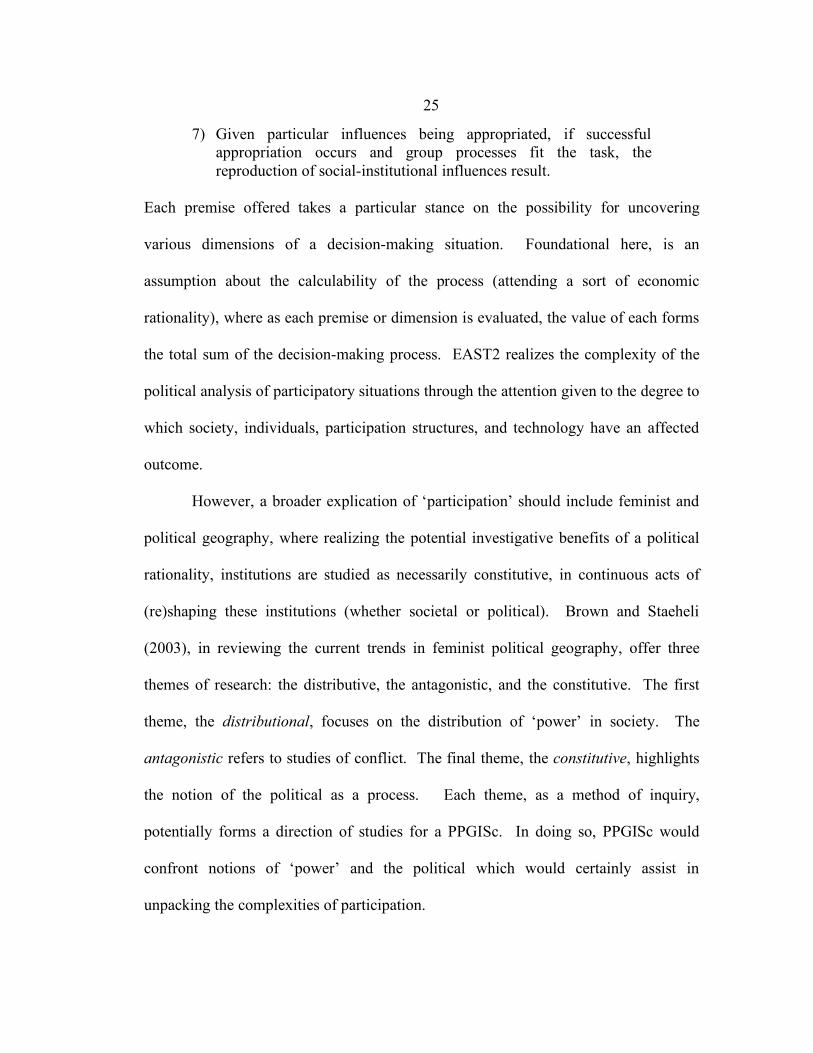
7) Given particular influences being appropriated, if successful appropriation occurs and group processes fit the task, the reproduction of social-institutional influences result.
Each premise offered takes a particular stance on the possibility for uncovering
various dimensions of a decision-making situation. Foundational here, is an
assumption about the calculability of the process (attending a sort of economic
rationality), where as each premise or dimension is evaluated, the value of each forms
the total sum of the decision-making process. EAST2 realizes the complexity of the
political analysis of participatory situations through the attention given to the degree to
which society, individuals, participation structures, and technology have an affected
outcome.
However, a broader explication of ‘participation’ should include feminist and
political geography, where realizing the potential investigative benefits of a political
rationality, institutions are studied as necessarily constitutive, in continuous acts of
(re)shaping these institutions (whether societal or political). Brown and Staeheli
(2003), in reviewing the current trends in feminist political geography, offer three
themes of research: the distributive, the antagonistic, and the constitutive. The first
theme, the distributional, focuses on the distribution of ‘power’ in society. The
antagonistic refers to studies of conflict. The final theme, the constitutive, highlights
the notion of the political as a process. Each theme, as a method of inquiry,
potentially forms a direction of studies for a PPGISc. In doing so, PPGISc would
confront notions of ‘power’ and the political which would certainly assist in
unpacking the complexities of participation.
26
Returning to Haklay’s critique of a lack of theoretical framing of PPGISc as
positioned by CPGIS, we can realize the great potential for continuing to interrogate
our assumptions and understandings of participation. Likewise, the theorizing of
participation should not serve to over complicate the development of PPGIS, but
should broadly bring the research and development of PPGISc to visible debates and
discussions within political geography, addressing a need drawn out by a discourse
analysis of CPGIS. By continuing to position PPGISc within this political discussion,
a viable and legitimate discourse emerges and the possibility for synergistic
scholarship informs new research strategies.
Conclusions
Community is not a static notion, but is defined in the achieving of it. (Delanty 2003: 124)
Delanty, in his book aptly titled Community, traces the theorizing of ‘community’
through different academic paradigms never resting on a stable or fixed definition of
the term. Likewise, he cites not one PPGISc researcher. There is a considerable
opportunity that exists for incorporating a theoretical framework of participation at the
object of study for PPGISc. The themes of democracy, community, and the citizen-
individual-participant as they are (re)negotiated within CPGIS are cogent reminders of
this opportunity. The citing of CPGIS in current PPGISc research demonstrates the
impact that this text has (and may continue to have) for future research in PPGISc. I
have argued that this text represents a discourse legitimizing a rather simplistic notion
of community as the principle theory for participation. This study has drawn out the
27
intertextual relationships between the CPGIS narrative and recent works of PPGISc
researchers using discourse analysis to reveal a need to visit and revisit how these
assumptions about ‘participation’ inform future system development situated in new
theories of PPGISc. Furthermore, a look into the potential beginnings for theoretical
framings of participation was explored by interrogating EAST2 (a theory of
participation for PPGISc) through a juxtaposing of themes of feminist political
geography.
As mentioned in the previous section, Brown and Staeheli (2003) offer three
approaches to problematize the political: the distributional, antagonistic, and the
constitutive. I have drawn attention to a lack of the constitutive approach to the
political within PPGISc, as supported by a discourse analysis of Community
Participation and GIS, questioning its role in (re)producing simplistic notions of
‘community’. A broadening of PPGISc research and practice necessarily must also
consider the distributional and antagonistic approaches. A distributional approach
refers to the distribution of ‘power’ (a notion I argue PPGISc research handles rather
unidimensionally) in decision-making situations, where an acknowledgment of
unequal access to political resources and potential advantages to control people and
processes should be a core concern in the research and practice of attending to
political struggle. An antagonistic approach to understanding the political in PPGISc
would additionally recognize the necessarily conflictual circumstances of decision-
making situations, and that any consensus-driven approach negotiates this conflict in
ways that may ultimately undermine the potential for realizing the distributional
28
approach to any democratic situation. Finally, a constitutive approach, consistent with
the questions I have posed in this chapter, interrogates the formation of a ‘we’ as a
necessary theoretical component for decision-making situations in PPGISc practice.
Realizing the constitutive quality of politics encourages PPGISc research to further
investigate any assumptions about the spaces of decision-making. Feminist political
geographers have emphasized the “spaces of home, neighborhood, work, religious
observance, and community” as spaces where the political is constitutively formed
(Brown and Staeheli 2003: 252). Likewise, this chapter has worried the assumptions
of the latter in a discourse analysis, questioning the (re)production of ‘community’ as
being the political motivation which informs the practice of PPGISc. Many more
questions have not been addressed; I have only explored a small portion of a much
larger project to uncover and resituate the research and practice of PPGISc in a way
which more adequately grapples with leading theoretical directions in feminist
political geography. Further examination of the intricacies of a notion of
‘participation’ in PPGISc is needed. In the following chapter, I intend to explore this
area of research and development by confronting a notion of ‘power’ implicit in
efforts to design methods of participations to support democratic decision-making.
29
Realizing multiple dimensions of ‘power’ in PPGISc: a comparison of methods to support structured participation
…to have equality, in a constitutive view, is to have institutions that create a certain set of activities, not produce a certain outcome. (Elkin 1985: 263)
This chapter addresses the need for a theoretical framing of a public participation
geographic information science (PPGISc) by inviting attention from political theory
around the notion of ‘power’. The object of study within a PPGISc (more broadly, a
‘critical’ GIS) is situated within the societal implications of a public participation
geographic information system (PPGIS), as an alternative to tool-based
understandings of GIS. In particular, PPGIS as a process within society presumes
normative understandings of topics like democracy, community, and the individual –
topics which academic fields like political theory continue to explore. The need to
support participation within a web-based PPGIS requires a consideration of the role
‘power’ plays in an explication of traditional methods for supporting same time, same
place (synchronous) decision-making as they might be applied to a different time,
different place (asynchronous) setting. This consideration assumes the constitutive
quality of political inquiry, where (extending Elkin 1985) the process of PPGIS lies in
the ways meaning is produced through its use in society.
Therefore, the study of synchronous participation methods hopes to offer
alternative ways of approaching and understanding the development of asynchronous
methods for engaging groups of people in participatory, GIS-supported decision-
making. Through a comparison of participation methods, general limitations for
synchronous participation methods are revisited, and the particular ways in which a
30
normative ideal of participant ‘power’ is implicated within these methods of
participation emerges from this comparison. This research discusses how power is
considered in public participatory geographic information science (PPGISc) where
structured methods of participation become the panacea for supporting deliberative
processes. As desktop GIS continues to evolve, PPGISc research moves forward new
ways to involve people, particularly in university-community partnerships (Leitner et
al. 2002). The PGIST project represents one such partnership and is studying the way
in which participation can be systematized while exploring the implications, as such,
for Internet applications which implement a notion of electronic-democracy in
transportation improvement program decision-making4.
The qualifier structured as often loaded with meaning in academic literature is
used here to denote participation methods that have a sequencing of specific group
activities as a set of procedures, chosen for their suitability to address a particular goal
or objective. However, other meanings of ‘structure’ should certainly be discussed, as
the necessary relationship exists between procedures or activities which offer structure
to group processes is always implicated in (re)negotiations of political structure
(whether through race, class, gender, sexuality or other forms of the constitutive
arrangement of the political). The PGIST project is interested in exploring structured
participation methods as a way to systematize participation for an analytic-deliberative
4 Transportation improvement program decision-making refers to the substantive issue of decision-making about the collection of improvement project scenarios that have approved funding.
31
process5 and therefore takes a stance toward providing organized activities to support
group processes in decision-making. The emergence of web services and distributed
Internet GIS make possible the opportunity to involve a large group of people in a
decision-making situation (Peng 2001, 1999; Dragicevic 2004; Dragicevic and Balram
2004). Questions remain: how can participation be structured in large group decision-
making? How do these methods of participation confront ‘power’ and shade the
resulting model of democratic participation that emerges?
These questions are analyzed, in two sections, where the notion of an
asynchronous public participation GIS is informed by: 1.) exploring the opportunities
and limitations of synchronous structured participation methods, by developing
comparison criteria and implementing a comparison of five participation methods; and
2.) discussing the handling of ‘power’ within these methods in relation to the potential
for multiple dimensions of ‘power’, by exploring the normative assumptions of
‘power’ constituted through these procedures. However, the situating of this study
within a validity network accommodating the interests of a PPGISc is first offered.
Secondly, the positioning of the original need for structured participation as central to
a system supporting deliberation is reviewed. Here, the importance of the limited
conceptual understanding of ‘power’ within these methods of structured participation
is drawn out as emerging from the Habermasian perspective of a pre-existing speech-
5 Analytic-deliberative describes a process where methods of data analysis (calculation, assessment, structuring of data or information) are incorporated within deliberation (structured or organized dialog) to assist in decision-making situations where a group of people are needed to discuss and analyze data (e.g. a discussion and ranking of alternative sites for environmental cleanup) (National Research Council 1996).
32
act situation. The five methods of structured participation are then introduced as the
supposed ends of a political process – a notion which is later problematized in the two-
part analysis section of the paper.
Confronting a lack of theoretical framing for PPGISc
Structured participation methods were realized as organized activities for
participants to generate and refine ideas, especially those designed to problem solve
and provide for “meaningful participation”, a notion discussed further in this section.
The PGIST project is faced with the dilemma of providing “meaningful participation”
in transportation decision-making to large groups, a study situated within the research
domain of PPGISc: developing new systems where participants are empowered to
contribute to a decision-making process while analyzing the social implications of
such a development. The difficulty then is in determining how empowerment is to be
measured, relating directly to the explication of ‘power’ and the adoption of a
particular model of democracy at the center of this system development. One might
turn to PPGISc for assistance in unpacking the notion of participation; however, as
Webler (1999) proposes, the lack of a comprehensive academic perspective in PPGISc
research, whereby practice informs theory and theory informs practice, limits the
development of the discipline and adds to theoretical fragmentation. Therefore,
research in PPGISc should continue to articulate a balance between the theoretical,
methodological, and the substantive domains of research.
33
2.1 Validity networks, or a research perspective
The distinction in research focus as a validity network schema6 allows for a
more thorough topic exploration, especially as applied to the expanding discipline of
PPGISc (cf. Nyerges, Jankowski, and Drew 2002; Elwood 2002a; Haklay and Tobón
2003). Within PPGISc research the trajectory of information offered through
participant interactions might be systematized. The systematization of participation is
a key component of a PPGIS design; likewise, the ability to systematize the
transformation of data within a participant group. Drawing on theories of cognition,
Nyerges (1993; 1995) traces data through transformations of information, knowledge,
and wisdom (organizational memory). Additionally, through these data
transformations, evidence as corroborated information is eventually realized, and
corroborated information (either for or against) leads to knowledge building in social
science research (Brinberg and McGrath 1985). Specific to the particular research
question in this study, evidence lies in the comparison of five structured participation
methods, and the discussion that emerges out of the framing of this comparison
confronting notions of ‘power’. This chapter discusses participation envisioned
6 As discussed in the introduction, these three domains (concepts, methods, substance) comprise a validity network schema, articulated by Brinberg and McGrath (1985), which can be used to demonstrate the multiple perspectives within PPGISc. The validity network schema is used to articulate a research process and the relationships that form a logical construction of validity that is “relative to purposes and circumstances.” (Brinberg and McGrath 1985: 13) Therefore, validity in PPGISc research is entirely dependent upon the focus of the research. Often information technology studies focus on developing new technological methods with which to study the occurrence of phenomena. Alternately, society and technology studies focus on the societal implications of not only the development, but most importantly the usage of those technologies to constitute the political, by using methods of social science, implicated in particular social theories.
34
through particular methods of structured activities. These processes, when compared,
illustrate a rather simplistic notion of ‘power’, highlighting general assumptions about
group decision-making realized through binaries of empowerment/marginalization,
consensus/dissensus, and individual/group interest. This research employs a validity
network schema comprised of theories of ‘power’ and participation, using a
comparison method, and the substantive study of particular procedures of group
activity.
2.2 Five methods to support group processes
Five methods have thus been identified within planning and management
literature as potential alternatives to conventional, unstructured group processes7.
These include nominal group technique, Delphi process, technology of participation,
open space technology, and citizen panel/jury (Delbecq, Van de Ven, and Gustafson
1975; Spencer 1989; Axelrod 2000; Brahm and Kleiner 1996; Dowling and St Louis
2000; Roth, Schleifer, and Switzer 1995; Turoff and Hiltz 1996; Andersen and Jaeger
1999). Each method was chosen for this comparison study as each offers a set of quite
different procedures to address similar consensus-driven outcomes. Each of these
methods, additionally are conceived prototypically as supporting group process which
is synchronous or near-synchronous (same time, same place). The practice of PPGISc
7 The PGIST project has identified over thirty methods of participation (cf. “Citizen Science Toolbox,” an Internet repository (Coastal Zone Australia Ltd. 2004)), and selected five methods which might best articulate the various approaches to structured group process. As this particular study focuses on particular notions of ‘power’ which emerge from a comparison of methods of participation, a minimal set of methods is needed to convey ontological and epistemological overlap. Even still, an attempt has been made to choose methods that have been popularly deployed in management and planning situations.
35
in large group processes makes any face-to-face solution unwieldy; therefore,
asynchronous methods seem a likely solution to support large group processes and the
comparison of procedures support this kind of development. Challenges for
modifying synchronous methods of participation to support online, asynchronous
participation shall now be further discussed.
2.3 Deliberative group process: from synchronous to asynchronous
The PGIST project is concerned with engaging a large group of people in an
Internet-based decision-making situation using tools which facilitate the analytic-
deliberative process. In much of previous PPGISc research, the analytic-deliberative
process has been implemented using face-to-face deliberative techniques (Leitner et al.
2000; Elwood 2002a; Leitner et al. 2002; Elwood and Leitner 1998; Ghose 2001;
Jankowski and Nyerges 2001; Craig, Harris, and Weiner 2002). As GIS-based
services are developed for access through the Internet, the possibility exists for
designing asynchronous techniques for deliberation, supported by GIS-enhanced
analytics. Jankowski and Nyerges (2001) envision online participation as a type of
meeting, among: 1.) conventional meetings (same time, same place), 2.) storyboard
meetings (different time, same place), 3.) conference call meetings (same time,
different place), and 4.) distributed meetings (different time, different place).
Assuming the complexities of decision-making situations, the possibility of using only
one type of arrangement to facilitate group decision-making is unrealistic.
Due to the focus of this study on asynchronous methods of structured
participation, a reading of Jankowski and Nyerges’s typology of meetings might

36
extend ‘place’ to mean virtual place in the PPGIS. This new typology would focus on
Internet-based tools employed across a spectrum of asynchronous settings (see table
2.31). Thus, the use of ‘meeting’ as a broad characterization of deliberation is
replaced with ‘session’, describing the virtual place of participation in an Internet-
based, participatory, GIS-supported, decision-making situation. Four types of session
arrangements emerge: 1.) grounded sessions, 2.) bulletin-board sessions, 3.)
conference sessions, and 4.) distributed sessions. Each depict a potential virtual
landscape for participants in the PPGIS. ‘Grounded’ refers to a session where all
participants deliberate at the same time on the same topic or analytic task. Bulletin-
board sessions allow participants to engage in a particular topic or task, at all times. A
conference session is a type of interaction that occurs where participants work on
many different tasks or discuss many different topics, but because they are using the
system at the same time, they are able to converse with other participants instantly. A
distributed session is one where participants explore many different topics and tasks at
any possible time. These four session arrangements depict a PPGIS where
participation occurs across combinations of time and virtual place. Place, as a virtual
creation necessary for online structured participation, informs the constitutive
construction of the political, as shall be discussed in the comparison section.
Certainly, the imagining of a ‘power’-free landscape of political opportunity which
drives the foundational understanding of deliberation should be seen as problematic.
For while the undertones of participants communicating within a leveled-playing field
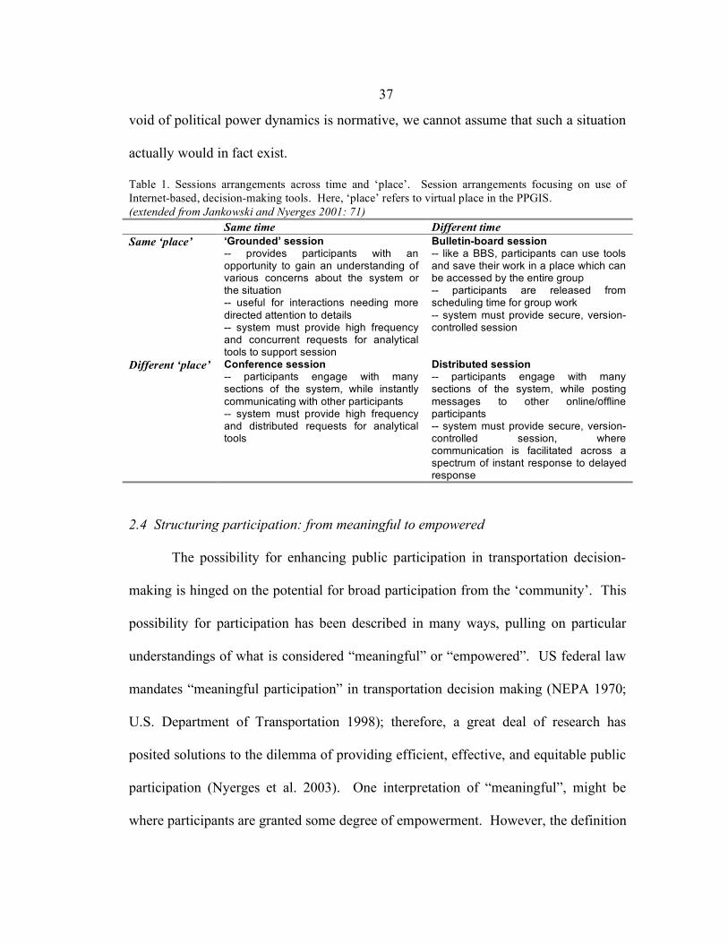
37
void of political power dynamics is normative, we cannot assume that such a situation
actually would in fact exist.
Table 1. Sessions arrangements across time and ‘place’. Session arrangements focusing on use of Internet-based, decision-making tools. Here, ‘place’ refers to virtual place in the PPGIS. (extended from Jankowski and Nyerges 2001: 71) Same time Different time Same ‘place’ ‘Grounded’ session
-- provides participants with an opportunity to gain an understanding of various concerns about the system or the situation -- useful for interactions needing more directed attention to details -- system must provide high frequency and concurrent requests for analytical tools to support session
Bulletin-board session -- like a BBS, participants can use tools and save their work in a place which can be accessed by the entire group -- participants are released from scheduling time for group work -- system must provide secure, version-controlled session
Different ‘place’ Conference session -- participants engage with many sections of the system, while instantly communicating with other participants -- system must provide high frequency and distributed requests for analytical tools
Distributed session -- participants engage with many sections of the system, while posting messages to other online/offline participants -- system must provide secure, version-controlled session, where communication is facilitated across a spectrum of instant response to delayed response
2.4 Structuring participation: from meaningful to empowered
The possibility for enhancing public participation in transportation decision-
making is hinged on the potential for broad participation from the ‘community’. This
possibility for participation has been described in many ways, pulling on particular
understandings of what is considered “meaningful” or “empowered”. US federal law
mandates “meaningful participation” in transportation decision making (NEPA 1970;
U.S. Department of Transportation 1998); therefore, a great deal of research has
posited solutions to the dilemma of providing efficient, effective, and equitable public
participation (Nyerges et al. 2003). One interpretation of “meaningful”, might be
where participants are granted some degree of empowerment. However, the definition
38
of empowerment seems to remain the responsibility of system designers; many
articulations of empowerment convey some sort of ladder-like imagery, premising
certain activities of informing as the foundation for any decision process (Arnstein
1969).
Arnstein (1969) puts forward the notion that citizen participation is an
expression of citizen power. Presupposing the process of informing a public,
Arnstein’s ladder of participation depicts a foundation of nonparticipation, which must
be overcome to reach the upper rungs of the ladder. Nonparticipation, here,
encompasses two rungs: 1.) manipulation, and 2.) therapy. Citizens are in effect
patronized, while those in power “‘educate’ or ‘cure’ the participants.” (Arnstein
1969: 217) Manipulation refers to the process whereby officials launch a public
relations effort to persuade a citizenry toward reaching an agreement. Therapy is the
insidious activity of engaging a citizenry in an activity, with the intent to disassociate
participant groups from their particular decision-making values. These two rungs of
the citizen participation ladder represent the lowest power holding for citizens. An
ethical structuring of citizen participation is meant to avoid the pitfalls of manipulation
and therapy and make the possibility of empowerment systematic and essentially
guaranteed.
The leap from ‘meaningful’ to ‘empowered’ seems substantial, and requires a
somewhat simplistic understanding of ‘power’ as something participants need to
obtain, requested, ironically, from those making the decision about how participants
should participate. What seems to be articulated is a form of deliberative democracy
39
(people are encouraged to discuss and debate issues of common interest), pulling on a
notion of classic pluralist ‘power’, defined as the amount of direct control one
participant has over another (Dahl 1961). This pluralist notion of ‘power’ must
contend with a notion of nonparticipation. Bachrach and Baratz (1962) critique Dahl’s
(1961) account of pluralism in describing two faces of power: one which is the
apparent decision-making process articulated by pluralists, and the second, the
insidious potential for nondecision-making. Nondecision-making, similar to
Arnstein’s nonparticipation, describes subversive acts of power, which disassociate
and coerce citizens in the decision-making process. However, this topic shall be taken
up in a later section.
2.5 Participation as a conversation
Participation methods must address several challenges, some of which might
be centered around group process as enabling: 1.) communication, 2.) cooperation, 3.)
coordination, and 4.) collaboration (Jankowski and Nyerges 2001: 50). Each level
begins another layer of complexity of group process, and therefore, each as procedures
are implicated in notions of ‘power’ pertaining to the activities of a participant. This
particular framework for unpacking the nature of ‘participation’ could be critiqued as
being implicated in an economic rationality for participant involvement, whereby the
focus is on analyzing the particular costs and benefits realized by the participants to
exhibit an underlying efficiency. Additionally, the normative ideal of communicative
rationality seems extended, where, as Habermas (1979) writes, the challenge is placed
on supporting the process of reaching an understanding. Habermas (1979) writes that
40
ideal conversation presumes certain claims of validity, focusing on communication.
What Habermas offers is a foundational norm for supporting group process, although
he and his supporters would argue that this theory of communicative rationality
merely describes an articulation of an ideal situation (and not foundational) (White
1988). For Habermas, ‘understanding’ in deliberative process is composed of four
claims of validty: 1.) comprehensibility, 2.) truth, 3.) truthfulness, and 4.) rightness
(Habermas 1979: 3). These procedures for supporting group process are supported by
deliberative and participatory democrats (Gutmann 1993; Gutmann and Thompson
2004; cf. Cunningham 2002), although critics argue that the application of such an
ideal speech situation naively assumes too much about the ways participants are given
voice (Young 1996, 1997).
The notion of a conversation brings scores of debate around what is assumed
epistemologically and ontologically when supporting a process of conversation
through a Habermasian tradition (cf. Calhoun 1992). As previously discussed, the
assumption of ‘understanding’ presupposes certain economic and communicative
rationalities within a public sphere. Fraser (1992) argues that Habermas (1989), in his
articulation of a public sphere based on a study of bourgeois society, inadequately
addresses contradictory public spheres where political power is not so easily
“bracketed and neutralized” (Fraser 1992: 115). Instead, Fraser warrants a new vision
of public sphere, and thus the possibility for deliberation (re)contested by multiple
publics. Deliberation, as Fraser writes, is composed of individual expression and
construction of cultural identity and requires an articulation that is constitutive.
41
Realizing participation as a conversation, or a set of conversations, necessitates
an engagement with various discussions about the act of communication. However,
the practice of PPGISc should engage with this complexity in defining participation,
worrying the assumptions made in adopting particular methods of structured
participation. As academicians and practitioners bring various methods of
participation under comparison (as this research intends), participation is shown to be
constitutive through the very procedures to which each adheres (whether
communicative or deliberative, or otherwise). Likewise a notion of ‘power’ in the
classic pluralist sense becomes quite unstable as the sense of the prepolitical
rationality of participants breaks down leaving an artifact of behavioral inquiry.
2.6 Participation imaginations
Tools built for the practice of PPGISc define participation as something
created, encouraged, and maintained (cf. Craig, Harris, and Weiner 2002). This notion
is exemplified in particular attempts to measure or provide a rationale for participation
processes, using metaphors like ladders and spectrums (Arnstein 1969; International
Association for Public Participation 2005). It is important to understand how these
five participation methods employ particular imaginations8 of participation as
something (from nothing), which is teased out of group processes and disciplined
8 Here, imagination is used as a method of deconstructive analysis, where the particular metaphors used in literature about participation (and methods of supporting participation) are telling of certain presuppositions by the author(s) – in a way, providing the grounds for describing certain epistemological and ontological limitations for such an account. This strategy is not new to political geography; Gregory (2004) uses the notion of a geographical imagination to describe how the political is constitutive through interactions (individual to global) addressing the constructions of safety and threat.
42
through structure in the form of specified procedures. The strategy of this thesis is to
describe this participation imaginary embedded within structured participation
methods as they are compared. Through the development of criteria for comparison
and the actual process of comparison, this imaginary is realized in terms of an
emerging notion of ‘power’.
Comparing five methods of supporting structured participation
Five participation methods have been selected by the PGIST project in a comparison
to inform development of a structured, asynchronous decision-making support system.
Each method can be clustered into two categorical models, which best describe the
context for their development and implementation within planning and management
literatures: 1.) judgmental participation, which describes a situation where a problem
seeks resolution through the use of deliberating ‘experts’, and 2.) organizational
change participation, which comes out of the context where an organization wishes to
make a change which best reflects the reservations and recommendations of all
members affected by a proposed change. These two models embody different theories
of democracy: the former more of a deliberative or participatory democracy, the latter
a communicative democracy, a theme that shall be discussed in greater detail later in
this section. Three methods shall be placed in the category of judgmental
participation: 1.) nominal group technique, 2.) Delphi process, and 3.) citizen
panel/jury. Two methods compared comprise the category of organizational change
43
participation: 1.) technology of participation, and 2.) open space technology. A brief
introduction to each method is offered here, with analysis in the following sections.
3.1 Scoping a decision situation: judgmental participation
Judgmental participation can be described as a situation where participant
“experts” are needed to address a lack of local (in this case, expert) knowledge or a
lack of consensus (Delbecq, Van de Ven, and Gustafson 1975: 5). Delbecq et al.
evaluate participatory methods using specific dimensions of judgmental decision-
making, to include: 1.) search behavior, 2.) normative behavior, 3.) equality of
participation, 4.) method of conflict resolution, 5.) and closure to decision process,
among others. (1975: 20) These dimensions reflect the judgmental participation
imagination, where emphasis is placed on the resolution of conflict as participants
drive toward consensus and a resulting judgment. The creators of nominal group
technique (NGT), Delbecq and Van de Ven, evaluated NGT in relation to the Delphi
process using this set of criteria, guided by this imaginary.
3.1.1 Nominal group technique
Nominal group technique (NGT) is a structured form of brainstorming or
brain-writing followed by a vote or prioritization in a synchronous setting, with up to
10 participants and an experienced facilitator (or 3 to 4 groups of up to 10 participants,
with a spokesperson for each group and a single facilitator overall). (Mycoted 2003)
Developed in 1968, Delbecq and Van de Ven write that NGT addresses equal
participation, creative expression of ideas, and aggregation techniques for judgment
(Delbecq, Van de Ven, and Gustafson 1975: 9) By giving each participant a chance
44
to submit an idea, creators of NGT believe they are ensuring equal participation. NGT
is considered a ‘creative’ process due to the nature of idea collection, clarification, and
evaluation. Participants are allowed to put forward ideas and clarify these ideas,
evaluated by other participants. Final judgment is computed using particular
prioritization aggregation techniques.
3.1.2 Delphi process
Delphi process, developed in 1950 by the Rand Corporation, is a series of
questionnaires, each building on the responses of previous questionnaires, which
require a panel of participants to synthesize and determine the nature of follow-up
questionnaires. Delphi’s strengths are believed to lie in the ability to collect
information from multiple participant ‘experts’ using iterative questionnaires and to
assist decision makers to produce an informed judgment. (Delbecq, Van de Ven, and
Gustafson 1975)
3.1.3 Citizen panel/jury
Citizen panel/jury, also known as a consensus conference, is a situation where
citizens are informed of an issue and encouraged to deliberate (through formal
presentation of evidence, argument, and rebuttal) to offer a solution to a governing
body. (Jefferson Center 2004; Sclove 2000) Consensus conferences, Sclove (2000)
writes, were developed to ensure democratic involvement of all affected citizens in
policy decisions (Sclove 2000: 33). Similar to Delphi process, an ‘expert’ panel is
formed to prepare position statements to address a particular problem. Citizens form a
lay panel and are encouraged to ask questions which will assist in their development
45
of a report of recommendations. The sense of democratic engagement rests on the
possibility that every participant (in this case, an ‘affected citizen’) is able to
contribute to the panel, whether in the form of a question or point of clarification.
Final judgment rests in the hands of the board of decision makers, who take the
considerations of the ‘expert’ position papers and the lay panel recommendations
report.
3.2 Deliberating toward a shared understanding: organizational change participation
Organizational change participation is distinct from judgmental participation
due to the deployment context for each, as well as what seems to be different
democratic models. As organizations grow, involving members in a discussion of a
proposed change is a strategy for balanced growth and is supported through methods
of organization change (Spencer 1989; Axelrod 2000). Members are encouraged to
deliberate over their reservations and recommendations for the organization. By
promoting a shared understanding among members, as it is assumed, organizational
elites can better make decisions regarding necessary changes. Technology of
participation and open space technology demonstrate two such methods of
organizational change participation.
3.2.1 Technology of participation
Technology of participation (ToP) is a participatory process of defining a
context for discussion through brainstorming, ordering, labeling, and evaluating of
individual ideas. People are selected based upon a stake in the development and/or
implementation of a strategic plan. (Spencer 1989) As an organizational change
46
method of participation, ToP demonstrates an ability to allow members an opportunity
to suggest items for deliberation through structured discussion activities.
3.2.2 Open space technology
As a different approach from ToP, open space technology (OST), developed in
the mid-1980s by Harrison Owen, allows participants to formulate a structure for
discussion by using the imaginary that order is formed somewhat organically, in what
seems to be a largely unstructured deliberation. In this particular organizational
change participation method, participants enter a room where multiple discussions are
taking place. As a participant decides to formally announce the topic of interest, a
gesture is made to inform the entire group of a particular discussion. Any participant
can announce discussions at any time. Clustering occurs where interested participants
can mingle from discussion group to discussion group. When discussion ends, the
participation method terminates (Axelrod 2000).
3.3 Criteria of participation method comparison
The comparison of these five structured participation methods comprise the
basic argument that each method, while differing in procedure, assumes a particular
understanding of deliberation – a participation imagination, wherein citizens become
participants through particular activities and rationalized assumptions in a democratic
process. In this section, comparison criteria are offered as a vehicle for laying claim to
procedural differences (specialization for a particular task) amid assumptive similarity.
As in any comparative study, the choice of criteria for evaluation immediately
implicates the researcher in particular normalized notions of participation. However,
47
the usefulness of such a set of criteria for evaluation allows a somewhat systematic
portrayal of similarity and difference in the way in which each sequence the
procedures of deliberation. As such, these criteria of comparison are limited due to
their situatedness within the participation imaginary of certain assumptions about
‘power’ and democracy. Therefore an understanding of procedural differences is
really the extent to which such criteria are useful; to additionally unpack the
assumptive similarities of the methods, a critical reading of these methods is needed (a
topic which is visited in the following section). With this disclaimer worrying the
work that this comparison performs, an introduction to the dimensions of comparison
is appropriate:
• Purpose is a rationale for the participation process. This paper has explored
participation methods as categorized by two particular purposes (as models):
judgmental participation and organizational change participation.
• Procedure describes the known techniques required in implementation of a
method. Techniques within participation methods can be further analyzed as
participation primitives, i.e. basic steps in the process.
• Expected outcome is the intended product or milestone from the effective
interaction within the participation method.
• Iterative requirement is the number of required interactions to accomplish the
expected outcome of the participation method.
• Size of group is the number of participants that can participate effectively
within the constraints of a setting.
48
• Timing is the expected length of the effective interaction session.
• Facilitator presence/role is the responsibility of the facilitator (if any) in the
participation method.
• Synthesis process is the way in which synergies among participants’ ideas are
identified and moved forward during the participation process. Potential for
greater participant empowerment resides in the details of this process.
These criteria help to distinguish these five participation methods as different
procedural-based participation structures (as is shown in table 3.31, for review of the
details of each method). Each participation method demonstrates a different
sequencing of activities, as brought out in the comparison along the criteria of
procedures. However, each broadly represents a similar imagination of participation
steeped in economic and communicative rationality where participants evaluate costs
and benefits to determine appropriate decisions and are assumed to have the ability to
come to an understanding with other participants. As was hinted to earlier, within a
constitutive rationality of the political we cannot assume that such a situation actually
would in fact exist.
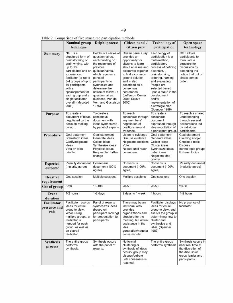
49
Table 2. Comparison of five structured participation methods.
Nominal group
technique Delphi process
Citizen panel /
citizen jury Technology of participation
Open space technology
Summary
NGT is a structured form of brainstorming or brain-writing, with up to 10 participants and an experienced facilitator (or up to 3-4 groups of up to 10 participants, with a spokesperson for each group and a single facilitator overall) (Mycoted 2003)
Delphi is a series of questionnaires, each building on the responses of previous questionnaires, which requires a panel of participants to synthesize and determine the nature of follow-up questionnaires. (Delbecq, Van de Ven, and Gustafson 1975)
Citizen panel / jury provides an opportunity for citizens to learn about an issue and deliberate together to find a common ground solution and is also described as a consensus conference. (Jefferson Center 2004; Sclove 2000)
Technology of participation is a multi-method, participatory process of defining a context, brainstorming, ordering, naming, and evaluating. People are selected based upon a stake in the development and/or implementation of a strategic plan. (Spencer 1989)
OST allows participants to formulate a structure for discussion by extending the notion that out of chaos comes order.
Purpose
To create a document of ideas negotiated by the decision-making group.
To create a consensus document with ideas synthesized by panel of experts.
To reach consensus through jury members’ negotiation of positions around evidence.
To create a consensus document expressed through idea negotiation of a participant group.
To reach a shared understanding through several deliberations led by individual participants.
Procedure
Goal statement Brainstorm ideas Clarify/negotiate ideas Vote on idea priority
Goal statement Generate ideas Collect ideas Synthesize ideas Playback ideas Request for further change
Listen to evidence Discuss evidence Negotiate positions Vote Repeat until reach consensus
Goal statement Generate ideas Collect ideas Cluster ideas Synthesize ideas Label ideas Negotiate idea priority
Goal statement Claiming a topic Choose a topic Discuss Iterate topic groups Exhaust topics
Expected outcome
Plurality document (majority agree)
Consensus document (100% agree)
Consensus document (100% agree)
Consensus document (100% agree)
Plurality document (majority agree)
Iterative requirement
One session Multiple sessions Multiple sessions One sessions One session
Size of group 5-20
10-100
20-50
20-50
20-50
Event duration
1-2 hours
1-2 days 2 days to 1 week
4 hours
1-2 hours
Facilitator presence and
role
Facilitator records ideas for entire group to view. When using multiple groups, a facilitator is needed for each group, as well as an overall facilitator.
Panel of experts synthesizes ideas (based on participant ranking) for presentation to participants.
There may be an individual who provides organizations and structure for the meeting, but actual assistance in the idea generation/negotiation is minute.
Facilitator displays ideas for entire group to view, and assists the group in determining how to cluster and synthesize and label. (Spencer 1989)
No presence of facilitator
Synthesis process
The entire group performs synthesis.
Synthesis occurs with the panel of experts.
No formal clustering or synthesis of ideas occurs; group may discuss/debate until consensus is reached.
The entire group performs synthesis.
Synthesis occurs in near real time at the discretion of the discussion group leader and participants.
50
3.4 Specialization and similarity
In implementing the criteria described in the previous section to compare five
structured participation methods, two themes seem to emerge: specialization and
assumptive similarity. ‘Specialization’ refers to the procedural differences of the five
methods, due simply to the fact that each was developed to support group processes in
a particular substantive situation (e.g. generating an ‘expert’ opinion for locating an
alternative energy factory; or gathering a response for a proposed merger). Each
method offers a particular ordering of a specific set of the following procedures (see
table 3.31):
1. Goal stating/context setting: This activity allows participants the opportunity
to provide context for the events to follow, including deliberation on a
proposed agenda.
2. Brainstorming/generating ideas: Participants are encouraged to submit
multiple ideas over a period of time to contribute to the decision situation.
3. Negotiating/clarifying ideas: Participants discuss generated ideas, and in the
process clarifying the idea for the entire group.
4. Clustering/synthesizing/labeling ideas: As participants negotiate and clarify
ideas, some ideas may be clustered and merged with other ideas in a synthesis
process. Clustered ideas may be given a new name or label.
51
5. Voting/prioritizing: Voting and prioritizing can be used to gauge participants’
objectified priorities during a decision situation, especially in the case of very
large groups.
6. Surveying: A survey may be used to gather a more subjective response (in
relation to voting/prioritizing) from participants during a decision situation,
especially for very large groups.
7. Reviewing/evaluating: Participants review and evaluate a decision-making
process as a way of providing feedback or becoming more informed about the
process.
The realignment of these procedures would inform the specialized practice of PPGISc
as a schema for structured participation. The usefulness of the comparison criteria
allows a view of these separated activities, while forming the backdrop for a critical
reading of the possibilities for structured participation.
This thesis argues that the positioning of ‘power’ within structured
participation is of crucial importance to the practice of PPGISc, more specifically that
the notion of ‘power’ within methods of participation is largely that of simple
capacity; therefore, discussion cannot end at the simple procedural comparison of
structured participation methods. The way in which this comparison draws out the
assumptive similarity of all five methods compared here is important to the unpacking
the particular positioning of ‘power’. All methods employ an idea-generation process,
whether through brainstorming, arguing evidence, or staking a claim to particular
topics for discussion. Each activity assumes a participant is motivated to present ideas
52
in deliberation toward a shared understanding (consensus). The methods assume a
certain Habermasian perspective of underlying validity and understanding, where
‘power’ is checked at the door and participants assume a leveled, depoliticized playing
field. The methods seem to exhibit procedural characteristics of three models of
democracy: participatory, deliberative, and communicative (as articulated by Young
(1996; 1997) to be distinct from the deliberative model). However, the entire project
of structuring participation (as captured by this comparison of five methods) enforces
a particular notion of ‘power’ informed by classic pluralism. Therefore, particular
democratic models chosen by PPGISc researchers inform the strategy of participation,
as well as determines the way the political is (re)constituted. What is needed is a
discussion of these democratic models which confronts ‘power’, in order to fully
situate a comparison of structured participation methods.
Confronting ‘power’ within methods of structured participation
Several questions should be posed for a theory of participation within PPGISc,
including implications of a constitutive politics and a destabilized and multiple
conception of ‘power’. The comparison of different methods of structured
participation has demonstrated the procedural differences of each method; however,
the limitations for implementing these methods of participation in the practice of
PPGISc was unclear, due in part to the foundational rationality (discussed as
assumptive similarity) inherent to each method and the criteria that were formed to
articulate their systemic differences. In this section, two approaches are taken to
53
worry these foundations: 1.) the relationship between the five methods of structured
participation and models of participatory, deliberative, and communicative democracy
is discussed; 2.) the classic pluralist notion of ‘power’ is discussed as implicit within
these five methods of structured participation.
The importance of this comparison is to realize the connections these methods
make to models of democracy, to include participatory, deliberative, and
communicative democracy. Participatory democracy, Cunningham (2002) writes,
represents a turn toward consensus through decision-making and “democratic
training” for a directly participating public. Participatory democrats saw institutions
like voting as encouraging apathy, and offered the solution of consensus as an
instrument to inspire political engagement. Deliberative democracy, like participatory
democracy, is motivated toward consensus-building; however, deliberative democrats
(e.g. Gutmann 1993; Gutmann and Thompson 2004) place an emphasis on
deliberation informed by a Habermasian ideal speech situation, thus privileging formal
argument as the mode of participation. Young (1996; 1997), in responding to the lack
of a perspective of difference in deliberative democracy, describes communicative
democracy as opening the form of dialog for participants, challenging a cultural bias
toward formal argument.
The methods of structured participation could be said to exhibit characteristics
of each of these models of democracy. By aligning these models with the intent to
provide structured participation in the practice of PPGISc, the possibility for a greater
understanding of the process emerges from inquiry within political theory; bridging
54
these disciplines necessarily brings about new perspectives for system development.
All presuppose the ideal situation where participants are ‘directly’ involved in
decision-making; albeit that Delphi process and citizen panel/jury privilege an ‘expert’
panel as part of the group process. Each method has consensus (or likewise,
consensus-building) as a desired outcome of the process, an ideal very much aligned
with these models of democracy (especially deliberative and communicative).
Likewise, each method assumes a Habermasian (1979) notion of universal
understanding through that of a communicative rationality (comprehensibility, truth,
truthfulness, and rightness), a notion true of each model of democracy analyzed here.
It is important to note Young’s (1996) critique of deliberative democracy which
worried the notion of a prepolitical individual participating in consensus building to
contribute to a common good. The notion of consensus, throughout these methods of
participation and models of democracy inform an analysis of their theorizing of
‘power’ – one which I argue is actually rooted in classic pluralism.
Cunningham’s (2002) reading of classic pluralism (cf. Dahl 1961) positions
this normative theory (or utopia) as guided by empirical studies of group interest and
an understanding of ‘power’ as an endless political resource used to persuade a
governing body. Here, the notion of group interest, as a form of collective allows
classic pluralists a way to describe political situations where individuals are
empowered by becoming involved in as many organizations of interest as desired.
The way collective interest is negotiated is bracketed off by classic pluralists (telling
of their particular notion of ‘power’ in a depoliticized decision-making situation).
55
These methods of participation and models of democracy rely on this pluralist notion
of ‘power’, where participants are expected to involve themselves based on their
interest or perspective which is aligned with group interest. The drive toward
consensus (although realized by these models of participation as being improbable)
mobilizes a political ‘we’ and, therefore, a ‘they’, where individual differences (or
goods) are put aside in return for a ‘common’ good. That which is common, or the
group interest, is nondecided in this handling of power. Bachrach and Baratz (1962)
level their critique at this problematic of who decides what interests are ‘important’ or
‘unimportant’. They argue that a second face of power – non-decisionmaking – exists
where the process itself disempowers the participant.
Barry Hindess, in Discourses of Power, traces the multiple dimensions of
power, the first two described previously (that of simple capacity, or the power
exercised over another, and legitimate capacity, or the power of the consent to be
governed through non-decisionmaking), and articulates a third dimension of power
(extending Lukes 1974):
[T]here may also be instances of the exercise of power in which its victims fail even to recognize that their real interests are at risk, and consequently make no attempt to defend those interests. On this view, there is a third, particularly insidious, form of power which is able to influence the thoughts and desires of its victims without their being aware of its effects. (Hindess 1996: 5)
Certainly these methods of structured participation and models of democracy confront
‘power’ as a simple capacity, bracketing off the potential for multiple dimensions of
‘power’. The problem with this notion, Hindess continues, is that of the
indeterminacy of conflict. The simple (or quantitative) capacity of ‘power’ assumes
56
conflict to be calculable, a “simple product of initial conditions” for a prepolitical
group of individuals. This is the largest limitation for methods of structured
participation which handle conflict in this way. By broadening the way ‘power’ is
confronted, the potential for a practice of PPGISc seems very promising.
Futures for structured participation in a PPGISc
Asynchronous, online versions of the five structured participation methods compared
here might look very similar due to the participation imagination that I argue each
employ, based on a notion of ‘power’ as simple capacity in a depoliticized decision-
making situation. PPGISc must come to grips with the way procedures imply a
depoliticized political in ways that potentially undermine democracy (electronic or
otherwise). Frissen (1997) recognizes the depoliticizing effect of increased procedure
and structure of the political:
The traditional centralist model of steering, based upon the idea of a rational actor, planning and deciding from one point, is substituted by a model that honours differentiation, variety and pluralism, while not considering these as limitations to be overcome. (Frissen 1997: 118)
Frissen’s frustration is certainly pertinent here, having reviewed methods of structured
participation; the advent of participatory decision-making using methods of structured
participation to support a differentiated public invokes a notion of the political where
‘power’ is often removed from the equation, or as mentioned in the previous section,
where any conflict is pre-calculable. By leaning on consensus as a motivation for
participation, the practice of PPGISc may be open to critique, following Weber
57
(1946), that the increased organization and bureaucracy of society’s institutions
undermine the democratic project (cf. Ferguson 1984).
Critics of PPGISc might argue the necessary ‘oppression’ inherent to
democratic projects using instruments of consensus as the operation of participation,
for reasons articulated in the previous section (having to do with the way ‘power’ is
handled). Oppression, detailed by Cunningham, occurs through mechanisms like
voting, whereby participants are involved passively, due to a lack of “knowledge, …
skills, … [and] expectations for taking charge of their lives” (2002: 133). Participatory
democracy arrives as a supposed way to quell this problem, through the use of direct
(problematically assumed to be ‘active’) participation. Through direct participation,
individuals are supposedly transformed out of irrationality towards a “civic-minded
citizen” capable of the knowledge, skills, and expectations needed to break free of
oppression (2002). The response then, offered by theorists of participatory democracy
(and assumably deliberative and communicative models), moves away from
democratic procedures such as voting and towards consensus through group decision-
making. However, Cunningham’s analysis of oppression assumes a simple capacity
notion of ‘power’, limiting his argument to a notion of the political within that single
dimension. In addition, the notion that individuals are trained to escape oppression,
through a “leveling of economic and social differences”, is how bureaucracy is
introduced, according to Weber (1946). The increased organization of society leads to
bureaucracy and the development of tools of oppression.
58
However, just the opposite may also be true, as Ferguson (1984), in
articulating a feminist project against bureaucratic organization, realizes the potential
for participatory decision-making to develop strategies and “structures for
coordination among the groups” (Ferguson 1984: 207). A fine line certainly exists for
PPGISc to either contribute to an already existing bureaucracy of hierarchy and
control, or contribute to the dismantling of bureaucracy through egalitarian practices
of small group participatory decision-making. The decision rests on how practitioners
and developers of PPGISc choose to investigate methods of participation, by
confronting a multi-dimensional ‘power’ and realizing how these structures handle
conflict.
This chapter has argued that the development of asynchronous methods of
structured participation to support online, decision-making within the practice of
PPGISc should realize the way ‘power’ is confronted. A comparison of five methods
of structured participation was used to illustrate procedural differences amid
assumptive similarity, later showing that this similarity premised on an understanding
of ‘power’ as simple (or quantitative) capacity largely limits any democratic project.
Finally, recognizing an underdeveloped, normative handling of race, class, gender,
sexuality, etc. in this research, I hope to have shown how a depoliticized decision-
making situation potentially emerges from procedures and structures leaning on
particular participation imaginations, potentially inviting additional critique for the
numerous ways each are performed within these spaces.
59
Conclusions
But to deepen our understanding of the impact of GIS as technology, object, practice, and social relation, it will be necessary to broaden the context within which the disciplinary history is written. (Pickles 1995: 237)
This thesis has been an attempt to articulate an appropriate response to Ground Truth
within the discipline of PPGISc, by calling into question the notions of ‘power’
PPGISc employs in research and practice. As Pickles (1995) writes in the above quote
from Ground Truth, some types of investigation will require a broadened academic
context for theoretical and methodological support. In the introduction, I detailed the
different perspectives of a validity network schema for PPGISc, wherein a particular
perspective of theoretical, methodological, and substantive domains allows for such a
broadened context for investigation. Chapter 2 was a discourse analysis of Community
Participation and GIS, attempting to call attention to the notions of ‘community’
within PPGISc research and practice. Chapter 3 presented a comparison of structured
participation methods, unpacking the underlying theoretical assumptions located in
this particular exercise, questioning the depoliticized character of instruments used to
support democratic decision-making.
Drawing on the approach Brown and Staeheli (2003) presents for unpacking a
constitutive approach to feminist political geography, a future for PPGISc continues to
be advancing systems which realizes political struggle, while investigating the various
ways any system has contingencies, outcomes, and implications (252-253). In this
thesis, I have explored instances in which a simplistic notion of ‘community’
implicitly assumes a quantitative notion of ‘power’, culled through discourse analysis,
60
emerging from a comparison of methods of structured participation, as a strategy to
begin to question these implications, outcomes, and contingencies. Certainly, I do not
propose that this has been a comprehensive investigation; however, I have intended to
demonstrate two approaches for PPGISc researchers to begin to worry our
assumptions of political ‘power’ in both research and practice.
Therefore, I have argued that Community Participation and GIS represents a
discourse legitimizing a rather simplistic notion of community as a theory of
participation. This discourse analysis has drawn out the intertextual relationships
between the CPGIS narrative and recent works of PPGISc researchers to reveal a need
to visit and revisit how these assumptions about ‘participation’ inform future system
development situated in new theories of PPGISc. Likewise, I have shown how the
development of asynchronous methods of structured participation to support online,
decision-making within the practice of PPGISc should realize the way ‘power’ is
confronted. A comparison of five methods of structured participation was used to
illustrate procedural differences amid assumptive similarity, later showing that this
similarity premised on an understanding of ‘power’ as simple (or quantitative)
capacity largely limits any democratic project.
A broader set of questions regarding the normative handling of race, class,
gender, sexuality, etc. within the depoliticized situations that much of PPGISc
research and practice envision would be a much larger project, and yet one which
PPGISc needs to confront to more fully understand the constitutive approach to
understanding political struggle. Additionally, the ways in which these norms are
61
inscribed in the spaces of decision-making describe a larger project as well, certainly
one that geographers would be well aligned with. This thesis has attempted to provide
an example of PPGISc research and practice engaging with these discussions in
feminist and political theory, and should be seen as a mere glimmer of potential in
rearticulating an agenda for PPGISc, one that theorists and practitioners can hopefully
find useful.
62
References
Aitken, Stuart C. 2002. Public participation, technological discourses and the scale of GIS. In Community Participation and Geographic Information Systems, edited by W. J. Craig, T. M. Harris and D. Weiner. New York: Taylor and Francis.
Aitken, Stuart C., and Suzanne M. Michel. 1995. Who contrives the "real" in GIS? Geographic information, planning and critical theory. Cartography and Geographic Information Systems 22 (1):17-29.
Andersen, Ida-Elisabeth, and Birgit Jaeger. 1999. Danish participatory models: Scenario workshops and consensus conferences: towards more democratic decision-making. Science and Public Policy 26 (5):331-340.
Arnstein, Sherry. 1969. Ladder of Citizen Participation. Journal of the American Institute of Planners 35:216-224.
Axelrod, Richard H. 2000. Terms of engagement: changing the way we change organizations. 1st ed. San Francisco: Berrett-Koehler.
Bachrach, Peter, and Morton S. Baratz. 1962. The two faces of power. American Political Science Review 57:947-952.
Balram, S. 2002. Book review: Community participation and geographic information systems. Environment and Planning A 34 (9):1711-1712.
Barndt, Michael. 1998. Public Participation GIS: Barriers to Implementation. Cartography and Geographic Information Systems 25 (2):105-106.
———. 2002. A model for evaluating public participation GIS. In Community Participation and Geographic Information Systems, edited by W. J. Craig, T. M. Harris and D. Weiner. New York: Taylor and Francis.
Brahm, Carolyn, and Brian H. Kleiner. 1996. Advantages and disadvantages of group decision-making approaches. In Team Performance Management: Bradford.
Brinberg, David, and Joseph Edward McGrath. 1985. Validity and the research process. Beverly Hills: Sage Publications.
Brown, Michael, and Lynn A. Staeheli. 2003. 'Are We There Yet?' Feminist Political Geographies. Gender, Place and Culture 10 (3):247-255.
Calhoun, Craig J. 1992. Habermas and the public sphere, Studies in contemporary German social thought. Cambridge, Mass.: MIT Press.
63
Coastal Zone Australia Ltd. 2005. Citizen Science Toolbox 2004 [cited April 16 2005]. Available from http://www.coastal.crc.org.au/toolbox/index.asp.
Craig, William J., Trevor M. Harris, and Daniel Weiner. 1999. Empowerment, marginalization and public participation GIS: Report of Varenius Workshop. Paper read at Varenius Workshop, October 1998, at Santa Barbara.
———. 2002. Community participation and geographic information systems. New York: Taylor & Francis.
Crampton, Jeremy W. 2002. The risks of security. Environment and Planning D: Society and Space 20 (6):631-635.
———. 2003. The Political Mapping of Cyberspace. Chicago: University of Chicago Press.
Cunningham, Frank. 2002. Theories of democracy: a critical introduction, Routledge contemporary political philosophy. London; New York: Routledge.
Curry, Michael R. 1995. Geographic information systems and the inevitability of ethical inconsistency. In Ground Truth: The social implications of geographic information systems, edited by J. Pickles. New York: Guilford Press.
Dahl, Robert Alan. 1961. Who governs? Democracy and power in an American city, Yale studies in political science, 4. New Haven: Yale University Press.
Dangermond, Jack. 2002. Mutualism in strengthening GIS technologies and democratic principles: perspectives from a GIS software vendor. In Community participation and geographic information systems, edited by W. J. Craig, T. M. Harris and D. Weiner. New York: Taylor & Francis.
Delanty, Gerard. 2003. Community. London: Routledge.
Delbecq, Andrâe L., Andrew H. Van de Ven, and David H. Gustafson. 1975. Group techniques for program planning: a guide to nominal group and Delphi processes. Glenview, Ill.: Scott Foresman.
Dowling, K. L., and R. D. St Louis. 2000. Asynchronous implementation of the nominal group technique: is it effective? Decision Support Systems 29 (3):229-248.
Dragicevic, Susan. 2004. The Potential of Web-based GIS. Journal of Geographical Systems 6:6-8.
64
Dragicevic, Susan, and S. Balram. 2004. A Web GIS collaborative framework to structure and manage distributed planning processes. Journal of Geographical Systems 6:133-153.
Duke-Williams, Oliver. 2003. Book review: Community participation and geographic information systems. Progress in Human Geography 27 (5):666-668.
Dwyer, C. 1999. Contradictions of community: questions of identity for young British Muslim women. Environment and Planning A 31 (1):53-68.
Elkin, Stephen. 1985. Economic and Political Rationality. Polity 18:253-271.
Elwood, Sarah A. 2002a. GIS use in community planning: a multidimensional analysis of empowerment. Environment and Planning A 34:905-922.
———. 2002b. The impacts of GIS use for neighborhood revitalization in Minneapolis. In Community Participation and Geographic Information Systems, edited by W. J. Craig, T. M. Harris and D. Weiner. London: Taylor & Francis.
Elwood, Sarah A., and Helga Leitner. 1998. GIS and Community-based Planning: Exploring the Diversity of Neighborhood Perspectives and Needs. Cartography and Geographic Information Systems 25 (2):77.
———. 2003. GIS and spatial knowledge production for neighborhood revitalizaiton: negotiating state priorities and neighborhood values. Journal of Urban Affairs 25 (2):139.
Feick, Robert D., and G. Brent Hall. 2004. A method for examining the spatial dimension of multi-criteria weight sensitivity. International Journal of Geographic Information Science 18 (8):815-840.
Ferguson, Kathy E. 1984. The feminist case against bureaucracy, Women in the political economy. Philadelphia: Temple University Press.
Foucault, Michel. 1972. The archaeology of knowledge. 1st American ed. New York: Pantheon Books.
Fraser, Nancy. 1992. Rethinking the Public Sphere: A contribution to the critique of actually existing democracy. In Habermas and the Public Sphere, edited by C. Calhoun. Cambridge, Mass.: The MIT Press.
Frissen, Paul. 1997. The virtual state. In The Governance of Cyberspace, edited by B. Loader. London: Routledge.
65
Ghose, Rina. 2001. Use of Information Technology for Community Empowerment: Transforming Geographic Information Systems into Community Information Systems. Transactions in GIS 5 (2):141-163.
Goodchild, M.F. 2002. Foreword. In Community participation and geographic information systems, edited by W. J. Craig, T. M. Harris and D. Weiner. New York: Taylor & Francis.
———. 2003. Geographic information science and systems for environmental management. Annual Review of Environment and Resources 28:493-519.
Goodchild, M.F., and Robert P. Haining. 2004. GIS and spatial data analysis: Converging perspectives. Papers in Regional Science 83 (1):363-385.
Gregory, Derek. 2004. The colonial present: Afghanistan, Palestine, and Iraq. Malden, MA: Blackwell Pub.
Gutmann, Amy. 1993. Democracy. In A Companion to contemporary political philosophy, edited by R. E. Goodin and P. Pettit. Oxford, UK; Cambridge, Mass.: Blackwell.
Gutmann, Amy, and Dennis Thompson. 2004. What deliberative democracy means. In Why Deliberative Democracy? Princeton: Princeton University Press.
Habermas, Jèurgen. 1979. What is Universal Pragmatics? In Communication and the Evolution of Society. Boston: Beacon Press.
———. 1989. The structural transformation of the public sphere: an inquiry into a category of bourgeois society, Studies in contemporary German social thought. Cambridge, Mass.: MIT Press.
Haklay, Mordechai. 2003. Book review: Community participation and geographic information systems. Environment and Planning B-Planning & Design 30 (2):319-320.
Haklay, Mordechai, and Carolina Tobón. 2003. Usability evaluation and PPGIS: towards a user-centred design approach. International Journal of Geographical Information Science 17 (6):577-592.
Harris, Trevor M., and Daniel Weiner. 1998. Empowerment, Marginalization, and "Community-integrated" GIS. Cartography and Geographic Information Systems 25 (2):67.
Harris, Trevor M., Daniel Weiner, Timothy A. Warner, and Richard Levin. 1995. Pursuing Social Goals Through Participatory Geographic Information Systems.
66
In Ground Truth: The Social Implications of Geographic Information Systems, edited by J. Pickles. New York: Guilford Press.
Harrison, Carolyn, and Mordechai Haklay. 2002. The Potential of Public Participation Geographic Information Systems in UK Environmental Planning: Appraisals by Active Publics. Journal of Environmental Planning and Management 45 (6):841-863.
Held, David. 1996. Models of democracy. 2nd ed. Stanford, Calif.: Stanford University Press.
Hindess, Barry. 1996. Discourses of power: from Hobbes to Foucault. Oxford, UK; Cambridge, Mass.: Blackwell Publishers.
International Association for Public Participation. 2005. IAP2 Public Participation Spectrum [PDF] 2005 [cited Jan. 22 2005]. Available from http://iap2.org/practitionertools/spectrum.pdf.
Jankowski, Piotr, and T. L. Nyerges. 2003. Toward a Framework for Research on Geographic Information-Supported Participatory Decision-Making. URISA Journal 15 (1):2003.
Jankowski, Piotr, and Timothy L Nyerges. 2001. Geographic Information Systems for Group Decision Making: Towards a Participatory, Geographic Information Science. Edited by P. Fisher and J. Raper, Research Monographs in Geographical Information Systems. London: Taylor and Francis.
Jefferson Center. 2004. Citizens Jury [webpage] 2004 [cited 29 Jan. 2004]. Available from http://www.jeffersoncenter.org/citizens_jury.htm.
Kwan, Mei-Po. 2002a. Feminist Visualization: Re-envisioning GIS as a Method in Feminist Geographic Research. Annals of the Association of American Geographers 92 (4):645-661.
———. 2002b. Is GIS for women? Reflections on the critical discourse in the 1990s. Gender, Place and Culture 9 (3):271-279.
Kyem, Peter A. Kwaku. 2004. Of intractable conflicts and participatory GIS applications: The search for consensus amidst competing claims and institutional demands. Annals of the Association of American Geographers 94 (1):37-57.
Leitner, Helga, Sarah A. Elwood, Eric Sheppard, Susanna McMaster, and Robert B. McMaster. 2000. Modes of GIS Provision and their Appropriateness for
67
Neighborhood Organizations: Examples from Minneapolis and St. Paul Minnesota. URISA Journal 12 (4):43-56.
Leitner, Helga, Robert B. McMaster, Sarah A. Elwood, Susanna McMaster, and Eric Sheppard. 2002. Models for making GIS available to community organizations: dimensions of difference and appropriateness. In Community Participation and Geographic Information Systems, edited by W. J. Craig, T. M. Harris and D. Weiner. New York: Taylor and Francis.
Lukes, Steven. 1974. Power: a radical view, Studies in sociology. London;New York: Macmillan.
Malczewski, Jacek. 2004. GIS-based land-use suitability analysis: a critical overview. Progress in Planning 62:3-65.
McCall, Michael K. 2003. Seeking good governance in participatory-GIS: a review of processes and governance dimensions in applying GIS to participatory spatial planning. Habitat International 27 (4):549-573.
Mycoted. Creativity Techniques 2003 [cited. Available from http://www.mycoted.com/creativity/techniques/index.php.
National Research Council. 1996. Understanding Risk: Informing Decisions in a Democratic Society. Edited by P. C. Stern and H. V. Fineberg. Washington, D.C.: National Academy Press.
Nellis, M. Duane. 2005. Geospatial information technology, rural resource development, and future geographies. Annals of the Association of American Geographers 95 (1):1-10.
NEPA. 1970. National Environmental Policy Act of 1969, Pub. L. 91-190, 42 USC 43214347, January 1, 1970, as amended by Pub. L. 94-52, July 3, 1975.
Nyerges, Timothy, Piotr Jankowski, and Christina Drew. 2002. Data-gathering strategies for social-behavioural research about participatory geographical information system use. International Journal of Geographical Information Science 16 (1):1-22.
Nyerges, Timothy L. 1993. How do people use geographical information systems? In Human Factors in Geographical Information Systems, edited by D. Medyckyj-Scott and H. Hearnshaw. London: Belhaven Press.
———. 1995. Cognitive issues in the evolution of GIS user knowledge. In Cognitive Aspects of Human-computer Interaction for Geographic Information Systems,
68
edited by T. L. Nyerges, D. Mark, M. Egenhofer and R. Laurini. Dordrecht: Kluwer.
———. 2004. GIS in Urban-Regional Transportation Planning. In Geography of Urban Transportation, edited by S. Hanson and G. Giuliano: Guilford Press.
Nyerges, Timothy L., Terrence Brooks, Christina Drew, Piotr Jankowski, G. Scott Rutherford, and Rhonda Young. 2003. An Internet Platform to Support Public Participation in Transportation Decision Making.
Obermeyer, Nancy J. 1998. The Evolution of Public Participatory GIS. Cartography and Geographic Information Systems:65-66.
Parker, Cheryl, and Amelita Pascual. 2002. A voice that could not be ignored: community GIS and gentrification battles in San Francisco. In Community Participation and GIS, edited by W. J. Craig, T. M. Harris and D. Weiner. London: Taylor & Francis.
Parker, Dawn C., Steven M. Manson, Marco A. Janssen, Matthew J. Hoffmann, and Peter Deadman. 2003. Multi-agent systems for the simulation of land-use and land-cover change: A review. Annals of the Association of American Geographers 93 (2):314-337.
Peng, Zhong-Ren. 1999. An assessment framework for the development of Internet GIS. Environment and Planning B-Planning & Design 26 (1):117-132.
———. 2001. Internet GIS for public participation. Environment and Planning B: Planning and Design 28 (6):889-905.
Pickles, John. 1997. Tool or Science? GIS, Technoscience, and the Theoretical Turn. Annals of the Association of American Geographers 87 (2):363-372.
———, ed. 1995. Ground Truth: The social implications of geographic information systems. New York: Guilford.
Radcliffe, S.A. 1999. Reimagining the nation: community, difference, and national identities among indigenous and mestizo provincials in Ecuador. Environment and Planning A 31 (1):5-17.
Ramsey, Kevin S. 2004. Stakeholder Involvement and Complex Decision Making: A Case Study into the Design and Implementation of a GIS for Supporting Local Water Resource Management. Master's, Department of Geography, University of Washington, Seattle.
69
Rose, Gillian. 2001. Visual methodologies: an introduction to the interpretation of visual materials. London; Thousand Oaks, Calif.: Sage.
Roth, Philip L., Lydia L.F. Schleifer, and Fred S. Switzer. 1995. Nominal group technique - an aid in implementing TQM. The CPA Journal 65 (5):68 (2).
Schuurman, Nadine. 2004. GIS: a short introduction, Short introductions to geography. Malden, MA.: Blackwell Pub.
Sclove, Richard E. 2000. Town Meetings on Technology: Consensus Conferences as Democratic Participation. In Science, Technology, and Democracy, edited by D. L. Kleinman. New York: State University of New York Press.
Sieber, R.E. 2003. Public participation geographic information systems across borders. The Canadian Geographer 47 (1):50-61.
Silk, J. 1999. The dynamics of community, place, and identity. Environment and Planning A 31 (1):5-17.
Sliuzas, Richard. 2003. Opportunities for enhancing communication in settlement upgrading with geographic information technology-based support tools. Habitat International 27 (4):613-628.
Spencer, Laura J. 1989. Winning Through Participation: Meeting the Challenge of Corporate Change with the Technology of Participation. Dubuque, IA: Kendall Hunt.
Staeheli, Lynn A. 2003. Women and the work of community. Environment and Planning A 35:815-831.
Staeheli, Lynn A., and Eleonore Kofman. 2004. Mapping gender, making politics: Toward feminist political geographies. In Mapping women, making politics: feminist perspectives on political geography, edited by L. A. Staeheli, E. Kofman and L. Peake. New York: Routledge.
Stonich, Susan C. 2002. Information technologies, PPGIS, and advocacy: globalization of resistance to industrial shrimp farming. In Community Participation and Geographic Information Systems, edited by W. J. Craig, T. M. Harris and D. Weiner. New York: Taylor and Francis.
Sui, Daniel Z. 2004. GIS, cartography, and the "third culture": Geographic imaginations in the computer age. The Professional Geographer 56 (1):62-72.
70
Turoff, M. S., and R. Hiltz. 1996. Computer-Based Delphi Processes. In Gazing in to the Oracle: The Delphi Method and its Application to Social Policy and Public Health, edited by M. Adler and E. Ziglio.
U.S. Department of Transportation. 1998. Transportation Equity Act for the 21st Century (TEA-21). In Public Law (PL) Title 23 Part 450.324 subpart C.
Weber, Max. 1946. From Max Weber: Essays in sociology. Edited by H. H. Gerth and C. W. Mills. New York: Oxford university press.
Webler, Thomas. 1999. The Craft and Theory of Public Participation: A Dialectical Process. Journal of Risk Research 2 (1):55-71.
Weiner, Daniel, Trevor M. Harris, and W.J. Craig. 2002. Community participation and geographic information systems. In Community participation and geographic information systems, edited by D. Weiner, T. M. Harris and W. J. Craig. New York: Taylor and Francis.
White, Stephen K. 1988. The recent work of Jèurgen Habermas: reason, justice, and modernity. Cambridge [Cambridgeshire]; New York: Cambridge University Press.
Young, Iris Marion. 1996. Communciation and the other: Beyond deliberative democracy. In Democracy and difference: contesting the boundaries of the political, edited by S. Benhabib. Princeton, N.J.: Princeton University Press.
———. 1997. Difference as a resource for democratic communication. In Deliberative democracy: essays on reason and politics, edited by J. Bohman and W. Rehg. Cambridge, Mass.: MIT Press.