Embed Size (px)
Citation preview
1
IMPORTANCE OF DISCRETE-ZONE MONITORING SYSTEMS IN FRACTURED-BEDROCK WELLS – A CASE STUDY FROM THE UNIVERSITY
OF CONNECTICUT LANDFILL, STORRS, CONNECTICUT
Carole D. Johnson, F.P. Haeni, and John W. Lane, Jr. (U.S. Geological Survey, Storrs, Conn., USA)
INTRODUCTION Monitoring of hydraulic head is an important part of many hydrogeologic investigations because
it is used to determine the rates and directions of ground-water flow. In unconfined aquifers, open-hole water levels can be used to establish meaningful conceptual models of ground-water flow. In heterogeneous fractured-rock aquifers, however, where the hydraulic head can be different for each fracture zone, open-hole water levels should not be used to determine the rates and directions of ground-water flow or to establish the conceptual model of ground-water flow.
In heterogeneous fractured rock aquifers, a discrete-zone monitoring (DZM) system is necessary to determine the spatial distribution and temporal variation of hydraulic head. The information provided by DZM systems can be used to determine vertical and horizontal hydraulic gradients, to identify connections between transmissive zones within the aquifer, and to establish the extent of connection between the fractured-rock and surficial aquifers.
Discrete-zone monitoring systems perform the equally important role of preventing cross contamination between fractures. When hydraulic heads associated with individual fracture zones vary within a single well, there is potential for vertical flow within the well. At contaminated sites, vertical flow can spread contamination through the open hole from zones of higher head to zones of lower head, which may have been previously uncontaminated (Williams and Conger, 1990). Results of analyses of water samples obtained from open holes where vertical flow has resulted in cross contamination can be ambiguous, misleading, or completely erroneous. In the presence of vertical flow, sampling at a low flow rate adjacent to a fracture does not insure that the water sample will come only from that fracture (Allen Shapiro, written commun.). A water sample drawn from an isolated fracture that was receiving water from a fracture with a higher head will be representative of the water in the fracture with the higher head. Installation of a DZM system soon after drilling minimizes cross contamination and ensures a water-quality sample from a discrete isolated zone.
CASE STUDY AT THE UNIVERSITY OF CONNECTICUT LANDFILL In 1999, the U.S. Geological Survey (USGS), in cooperation with the University of Connecticut
(UConn), used a suite of surface- and borehole-geophysical methods to characterize the hydrogeology of a fractured-rock aquifer near a former landfill at the University of Connecticut, Storrs, Connecticut (Johnson and others, in press). The purpose of this study was to identify contamination or pathways for contaminant migration. To further characterize the hydrogeology of the site, the USGS has installed DZM systems in seven wells. The wells are about 125 feet (ft) deep and are completed in 2 to 5 discrete zones. Vertical flow under ambient conditions was detected in four wells using a heat-pulse flowmeter, which can measure flows rates as low as 0.01 ± 0.005 gallons per minute (gpm). Because of the vertical flow in these wells, which ranged from about 14 to 300 gallons per day (gpd) (Johnson and others, 2001), a DZM system was required to prevent possible cross-contamination.
2
DESIGN AND INSTALLATION OF THE DZM SYSTEM FOR THE UCONN LANDFILL Before designing the DZM system for the boreholes at the UConn Landfill, it was necessary to
conduct geophysical logging (Shapiro and others, 1999; and Haeni and others, 2001) to determine (1) fracture locations, (2) the occurrence of any vertical flow in the borehole, (3) the location of hydraulically active fractures, and (4) the location of smooth unfractured portions of the borehole suitable for packer placement. For the UConn study, conventional and advanced geophysical logs, including caliper, natural gamma, fluid temperature, fluid resistivity, electromagnetic induction, deviation, optical and acoustic televiewer, heat-pulse flowmeter under ambient and pumped conditions, and directional radar reflection, were collected in seven bedrock wells (Johnson and others, in press b). The geophysical logging results were used to select packer locations, head monitoring, and sampling ports.
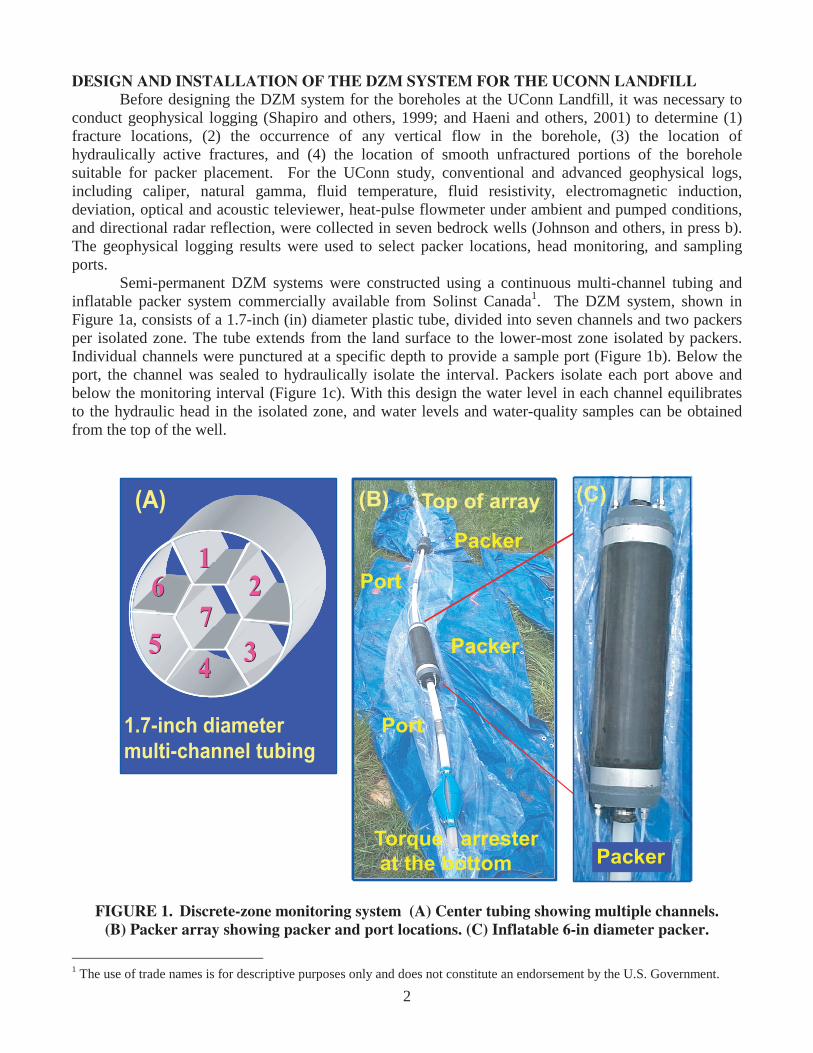
Semi-permanent DZM systems were constructed using a continuous multi-channel tubing and inflatable packer system commercially available from Solinst Canada1. The DZM system, shown in Figure 1a, consists of a 1.7-inch (in) diameter plastic tube, divided into seven channels and two packers per isolated zone. The tube extends from the land surface to the lower-most zone isolated by packers. Individual channels were punctured at a specific depth to provide a sample port (Figure 1b). Below the port, the channel was sealed to hydraulically isolate the interval. Packers isolate each port above and below the monitoring interval (Figure 1c). With this design the water level in each channel equilibrates to the hydraulic head in the isolated zone, and water levels and water-quality samples can be obtained from the top of the well.
Packer
Port
Packer
Port
Torque arresterat the bottom
Top of array(B)
Packer
Port
Packer
Port
Torque arresterat the bottom
Top of array(B)
Packer
Packer
Port
Torque arrester at the bottom
Top of array(B) (C)
1.7 diameterMulti-channel tubing
7755
1122
33
66
44
(C)
1.7-inch diametermulti-channel tubing
7755
1122
33
66
44
7755
1122
33
66
44
(A)
Packer
Port
FIGURE 1. Discrete-zone monitoring system (A) Center tubing showing multiple channels. (B) Packer array showing packer and port locations. (C) Inflatable 6-in diameter packer.
1 The use of trade names is for descriptive purposes only and does not constitute an endorsement by the U.S. Government.

3
The packers and tubing were assembled at land surface and then manually lowered in the well. The packers were inflated with water through ¼-in tubing, and the air in the packers was displaced through another ¼-in line above the land surface. The air-discharge line was then closed, and the packers were pressured to about 20 pounds per square inch (psi) over ambient pressure. An inline gage at the top of the well was used to monitor packer inflation. The packers typically lost some pressure over time and had to be re-inflated to 20 psi about once a month. The construction, testing, and installation of a DZM system in one well took approximately one day.
RESULTS
Long-term hydrographs provide a view of the hydraulic head over time. For the UConn study, water levels were measured manually with an electric water-level probe concurrent with packer inflation pressure monitoring. Water levels can also be measured continuously with small diameter (0.39-in diameter, or less) pressure-sensitive transducers that transmit to a data logger. A hydrograph constructed with manual measurements for bedrock well MW101R, located near a wetland, is shown in Figure 2. Well MW101R is completed as an open hole with 23 ft of 6-in diameter steel casing. Below the casing, the DZM system isolates four zones at elevations of 531 to 514.5 ft, 512.5 to 493.5 ft, 491.5 to 485 ft, and 483 to 426.5 ft above sea level. The lowest zone in the borehole has the highest head, and the uppermost zone has the lowest head (Figure 2a). The head in a nearby piezometers screened in the overburden is lower than any of the heads in the bedrock well (Haley and Aldrich, 1999). These results indicate an upward hydraulic gradient in the bedrock and between the bedrock and overburden. A heat-pulse flowmeter measured upward flow of 0.018 gpm between the fractures at elevations of 488.5 and 518.5 ft on August 26, 1999 (Johnson and others, in press). At this flow rate, if no packers are installed, about 26 gpd flows through the open borehole. The head data from the DZM system supports the heat-pulse flowmeter results. The DZM system also provides information about the magnitude of differential heads between fractures that did not have flow measurable with the heat-pulse flowmeter, and about the changes in water levels over time. The upward hydraulic gradient supports the conceptual model of ground-water flow that MW101R is completed in a ground-water discharge zone.
426.5 ft
513.5 ft1
3
2
Zone 1
Zone 2
Zone 3
Zone 4
1
484.0 ft
492.5 ft
553.5 ft
EL
EV
AT
ION
OF
TO
P A
ND
BO
TT
OM
OF
WE
LL A
ND
PA
CK
ER
S,
IN F
EE
T
5 49
550
551
552
553
0 6 /0 1 /0 0 0 7 /0 1 /0 0 0 8 /0 1 /0 0 0 8 /3 1 /0 0 1 0 /0 1 /0 0 1 0 /3 1 /0 0 1 2 /0 1 /0 0 1 2 /3 1 /0 0
D ATE
HE
AD
AB
OV
E S
EA
LE
VE
L, I
N F
EE
T
M W 101R
Z1 (22 .5 -39 ft)
Z2 (41 -60 ft)
Z3 (62 -68 .5 ft)
Z4 (70 .5 -127 ft)
Zone 1
Zone 2
Zone 3
Zone 4
FIGURE 2. (A) Hydraulic heads in four isolated zones in bedrock borehole MW101R, UConn
landfill, Storrs, Connecticut. (B) Schematic showing the packer locations in MW101R.
4
CONCLUSIONS The data obtained at the UConn landfill site using discrete-zone monitoring systems has helped
to establish, refine, and verify a conceptual model of ground-water flow in the study area. The results illustrate the importance of discrete-zone isolation and monitoring in fractured-rock aquifers to prevent cross contamination, to accurately measure hydraulic head at several depths, and to collect representative water-quality samples. ACKNOWLEDGMENT
The authors acknowledge the support of the Toxic Substance Hydrology Program in the early development of these methods. REFERENCES CITED Haeni, F.P., Lane, J.W. Jr., Williams, J.W., and Johnson, C.D., 2001, Use of a geophysical toolbox to characterize ground-water flow in fractured rock: Fractured Rock 2001, Toronto, Ontario, March 26-28, 2001, CD-ROM. Haley and Aldrich, Inc., 1999, Preliminary hydrogeologic investigation draft report, UConn landfill, Storrs, Conn.: Storrs, Conn., University of Connecticut, 22 p. Johnson, C.D., Haeni, F.P., Lane, J.W., and White, E.A., in press, Borehole-geophysical investigation of the University of Connecticut landfill, Storrs, Connecticut: U.S. Geological Survey, Water Resources Investigations Report 01-4033. Johnson, C.D., Lane, J.W., Jr., Williams, J.H., and Haeni, F.P., 2001, Application of geophysical methods to delineate contamination in fractured rock at the University of Connecticut landfill, Storrs, Connecticut: in Symposium on the Application of Geophysics to Engineering and Environmental Problems, Oakland, California, March 4-7, 2001, Proceedings: Wheat Ridge, Colo., Environmental and Engineering Geophysical Society, CD-ROM. Shapiro, A.M., Hsieh, P.A., and Haeni, F.P., 1999, Integrating multidisciplinary investigations in the characterization of fractured rock, in Morganwalp, D.W., and Buxton, H.T., eds., U.S. Geological Survey Toxic Substances Hydrology Program-Proceedings of the Technical Meeting, Charleston, South Carolina, March 8-12, 1999: U.S. Geological Survey Water-Resources Investigation Report 99-4018C, v. 3, p. 669-680. Williams, J.H., and Conger, R.W., 1990, Preliminary delineation of contaminated water-bearing fractures intersected by open-hole bedrock wells: Ground Water Monitoring Review, v. 10, no. 4, p. 118-126.