Embed Size (px)
Citation preview
IVerh. Internat. Verein. Limnol. 22 1828-1834 Stuttgart, Dezember 1984
Importance of streamside forests to large rivers:The isolation of the Willamette River, Oregon, U. S. A., from its
floodplain by snagging and streamside forest removal
,JAMES R. SEDELL and JUDITH L. FROGGATT
With 2 figures and 1 table in the text
Introduction
The river continuum concept (VANNOTE et al. 1980) stressed the point that the influence of theterrestrial system on a stream diminishes as the stream gets larger. The concept argued for greaterautochthonous carbon inputs and lower tributary inputs of carbon to higher order streams (7-9thorders). The role of floodplains in the river continuum concept was limited to decomposition ofparticulate organic material during periods of low water and the subsequent return of organic ma-terials by flood waters and surface runoff. This floodplain interaction existed naturally on all rivers,including lowland streams and very large rivers (9-12th orders).
The river continuum concept (VANNOTE et al. 1980) emphasizes some functions of streamsideforest in inferring a downstream decrease in influence, but does not give attention to other func-tions related to overbank flow that increase in importance downstream as outlined by WELCOMME(1979). WELCOMME (1979) examined the great floodplain rivers of the tropics and argued for a tightcoupling of the floodplain with the river system. His basic premise is that the productivity of flood-plain fisheries was dependent on the extent and duration of flooding. WissmAR et al. (1980) reportedthat inorganic and organic materials of terrestrial origin probably influenced the microbial activityof the mainstem Amazon River, its tributaries, and its varzea (floodplain) lakes.
The relationship of floodplain and mainstem in large rivers in North America and Europe nolonger exists and is rapidly disappearing in Africa, South America, and Asia. The influence of thefloodplains has been reduced by (1) the extent of local activities such as snagging the mainstem, dik-ing, and improved drainage of floodplains for agriculture or urbanization; and (2) reduction of theextent of flooding because of upstream activities such as flood control dams. These alterationswithin the stream and on the floodplain have modified the relationship between mainstem andfloodplain by changing the composition and structure of the floodplain vegetation and changing thesources and sinks for organic matter along large rivers. The combined effects isolate a river systemfrom the influence its floodplain has on the structure and nutrient capital of the aquatic ecosystem.
The river continuum concept (VANNOTE et al. 1980; WELCOMME 1979) hardly mentions the roleof downed trees in large rivers. The ecological role of wood in large rivers will never be completelyunderstood because wood has been systematically removed along most rivers around the world fortimber, firewood, or as obstructions to ship and barge navigation (SEDELL & LUCHESSA 1982).
SEDELL et al. (1982) document snags (downed trees) pulled from many rivers in virtually everyregion of the United States of America. Stream improvement for navigation was well financed bythe United States government from 1870 to the present. Over 800,000 snags were pulled in a 50 yearperiod along the lower 1600 km of the Mississippi River. The snags were primarily cottonwood andsycamore averaging 1.7 m in diameter at the base and 0.7 m at the top and had an average length of35 m (SEDELL et al. 1982).
These snags created shoals, dammed sloughs, caused large side jams, and often completelyjammed a lowland river. The historical records of streamside forests are the only evidence re-maining of the importance of downed trees to channel geomorphology in pristine rivers.
This report describes the pristine and present streamside forest, channel geomorphology, and
0368-0770/84/0022-1828 $ 1.75© 1984 E. Schweizerbart'sche Verlagsbuchhandlung, D-7000 Stuttgart I
J. R. Sedell & J. L. Froggatt, Importance of streamside forests 1829
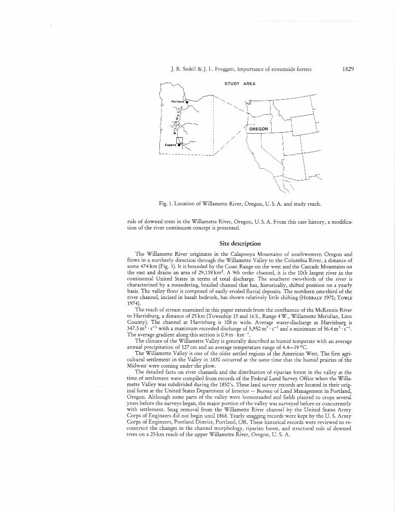
Fig. 1. Location of Willamette River, Oregon, U. S. A. and study reach.
role of downed trees in the Willamette River, Oregon, U. S. A. From this case history, a modifica-tion of the river continuum concept is presented.
Site description
The Willamette River originates in the Calapooya Mountains of southwestern Oregon andflows in a northerly direction through the Willamette Valley to the Columbia River, a distance ofsome 474 km (Fig. 1). It is bounded by the Coast Range on the west and the Cascade Mountains onthe east and drains an area of 29,138 km 2. A 9th order channel, it is the 10th largest river in thecontinental United States in terms of total discharge. The southern two-thirds of the river ischaracterized by a meandering, braided channel that has, historically, shifted position on a yearlybasis. The valley floor is composed of easily eroded fluvial deposits. The northern one-third of theriver channel, incised in basalt bedrock, has shown relatively little shifting (HoERAuF 1970; TOWLE1974).
The reach of stream examined in this paper extends from the confluence of the McKenzie Riverto Harrisburg, a distance of 25 km (Township 15 and 16 S., Range 4 W., Willamette Meridian, LinnCounty). The channel at Harrisburg is 108 m wide. Average water-discharge at Harrisburg is347.5 m 3 • s' with a maximum recorded discharge of 5,950 m 3 • s-1 and a minimum of 56.4 m3The average gradient along this section is 0.9 m • km-'.
The climate of the Willamette Valley is generally described as humid temperate with an averageannual precipitation of 127 cm and an average temperature range of 4.4-19 °C.
The Willamette Valley is one of the older settled regions of the American West. The first agri-cultural settlement in the Valley in 1830 occurred at the same time that the humid prairies of theMidwest were coming under the plow.
The detailed facts on river channels and the distribution of riparian forest in the valley at thetime of settlement were compiled from records of the Federal Land Survey Office when the Willa-mette Valley was subdivided during the 1850's. These land survey records are located in their orig-inal form at the United States Department of Interior — Bureau of Land Management in Portland,Oregon. Although some parts of the valley were homesteaded and fields planted to crops severalyears before the surveys began, the major portion of the valley was surveyed before or concurrentlywith settlement. Snag removal from the Willamette River channel by the United States ArmyCorps of Engineers did not begin until 1868. Yearly snagging records were kept by the U. S. ArmyCorps of Engineers, Portland District, Portland, OR. These historical records were reviewed to re-construct the changes in the channel morphology, riparian forest, and structural role of downedtrees on a 25 km reach of the upper Willamette River, Oregon, U. S. A.
1830 IX. Running Waters
Results and discussion
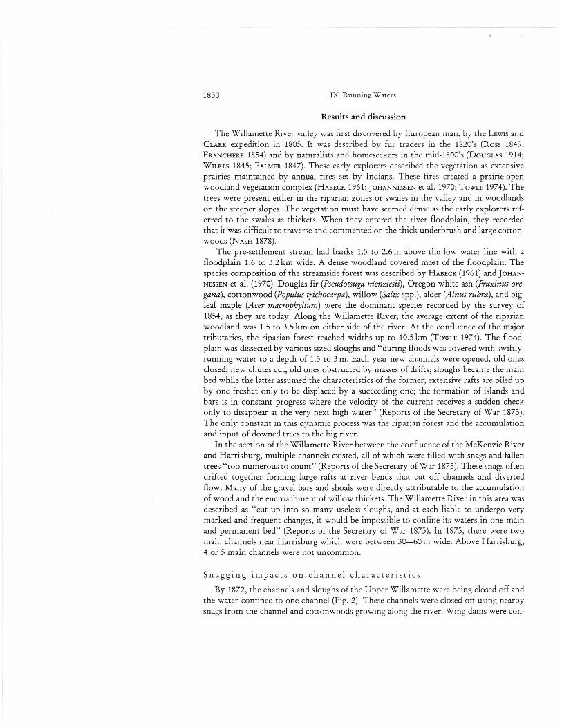
The Willamette River valley was first discovered by European man, by the LEWIS andCLARK expedition in 1805. It was described by fur traders in the 1820's (Ross 1849;FRANCHERE 1854) and by naturalists and homeseekers in the mid-1800's (DouGuis 1914;WILKES 1845; PALMER 1847). These early explorers described the vegetation as extensiveprairies maintained by annual fires set by Indians. These fires created a prairie-openwoodland vegetation complex (HABEcx 1961; JOHANNESSEN et al. 1970; TOWLE 1974). Thetrees were present either in the riparian zones or swales in the valley and in woodlandson the steeper slopes. The vegetation must have seemed dense as the early explorers ref-erred to the swales as thickets. When they entered the river floodplain, they recordedthat it was difficult to traverse and commented on the thick underbrush and large cotton-woods (NASH 1878).
The pre-settlement stream had banks 1.5 to 2.6 m above the low water line with afloodplain 1.6 to 3.2 km wide. A dense woodland covered most of the floodplain. Thespecies composition of the streamside forest was described by HABECK (1961) and JOHAN-NESSEN et al. (1970). Douglas fir (Pseudotsuga nienziesii), Oregon white ash (Fraxinus ore-gana), cottonwood (Populus trichocarpa), willow (Salix spp.), alder (Alnus rubra), and big-leaf maple (Acer macrophyllum) were the dominant species recorded by the survey of1854, as they are today. Along the Willamette River, the average extent of the riparianwoodland was 1.5 to 3.5 km on either side of the river. At the confluence of the majortributaries, the riparian forest reached widths up to 10.5 km (TowLE 1974). The flood-plain was dissected by various sized sloughs and "during floods was covered with swiftly-running water to a depth of 1.5 to 3 m. Each year new channels were opened, old onesclosed; new chutes cut, old ones obstructed by masses of drifts; sloughs became the mainbed while the latter assumed the characteristics of the former; extensive rafts are piled upby one freshet only to be displaced by a succeeding one; the formation of islands andbars is in constant progress where the velocity of the current receives a sudden checkonly to disappear at the very next high water" (Reports of the Secretary of War 1875).The only constant in this dynamic process was the riparian forest and the accumulationand input of downed trees to the big river.
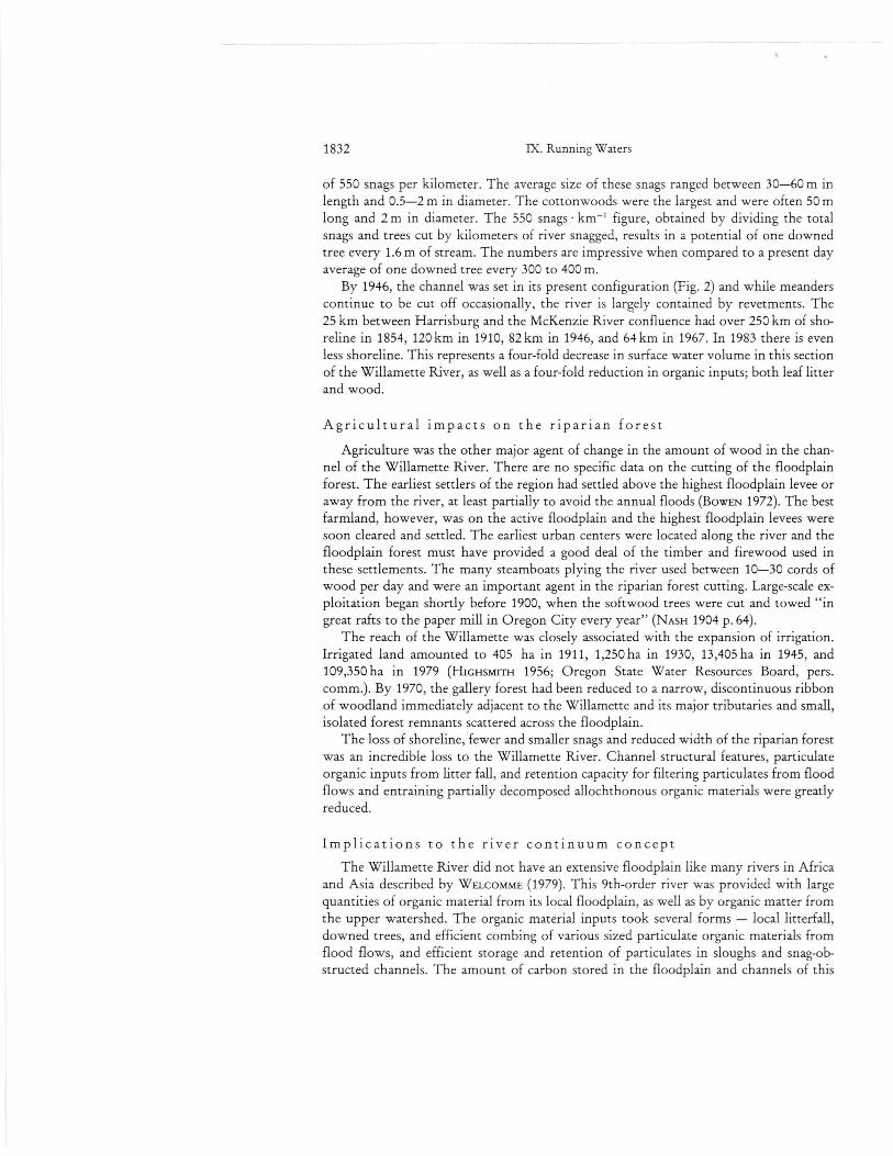
In the section of the Willamette River between the confluence of the McKenzie Riverand Harrisburg, multiple channels existed, all of which were filled with snags and fallentrees "too numerous to count" (Reports of the Secretary of War 1875). These snags oftendrifted together forming large rafts at river bends that cut off channels and divertedflow. Many of the gravel bars and shoals were directly attributable to the accumulationof wood and the encroachment of willow thickets. The Willamette River in this area wasdescribed as "cut up into so many useless sloughs, and at each liable to undergo verymarked and frequent changes, it would be impossible to confine its waters in one mainand permanent bed" (Reports of the Secretary of War 1875). In 1875, there were twomain channels near Harrisburg which were between 30-60 m wide. Above Harrisburg,4 or 5 main channels were not uncommon.
Snagging impacts on channel characteristics
By 1872, the channels and sloughs of the Upper Willamette were being closed off andthe water confined to one channel (Fig. 2). These channels were closed off using nearbysnags from the channel and cottonwoods growing along the river. Wing dams were con-
IN1 km■-•
4
4-1946 1967
J. R. Sedell & J. L. Froggatt, Importance of streamside forests 1831
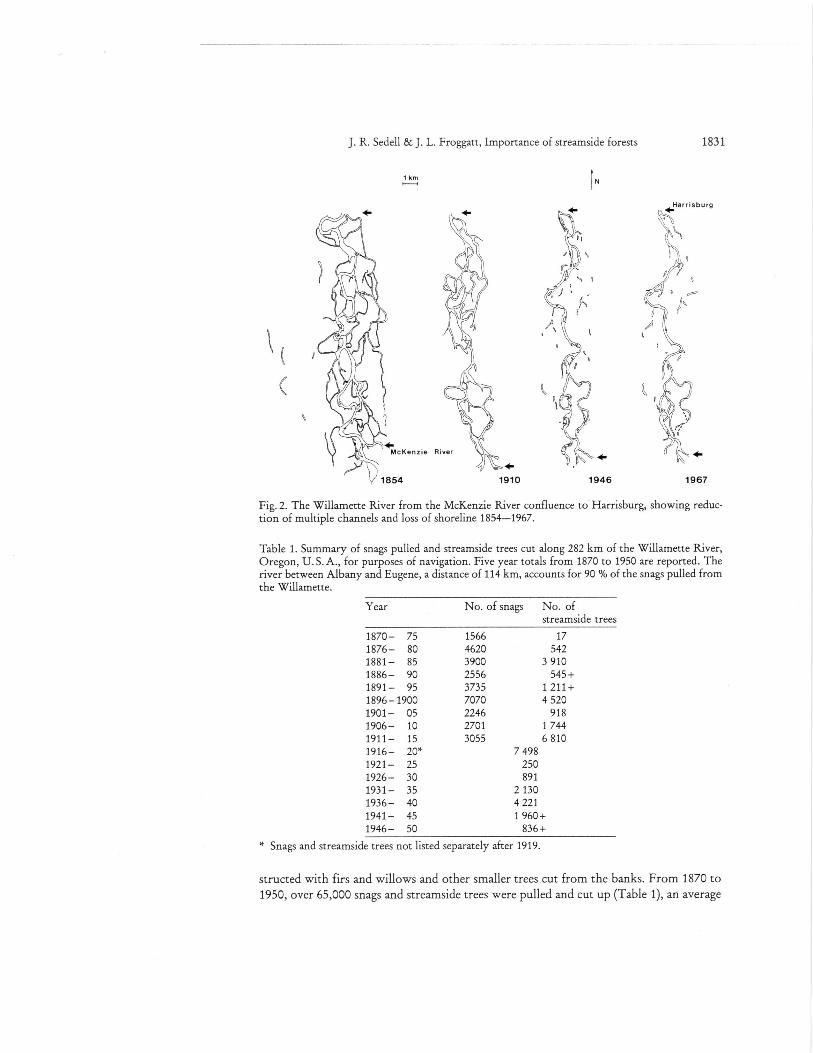
Fig. 2. The Willamette River from the McKenzie River confluence to Harrisburg, showing reduc-tion of multiple channels and loss of shoreline 1854-1967.
Table 1. Summary of snags pulled and streamside trees cut along 282 km of the Willamette River,Oregon, U.S. A., for purposes of navigation. Five year totals from 1870 to 1950 are reported. Theriver between Albany and Eugene, a distance of 114 km, accounts for 90 % of the snags pulled fromthe Willamette.
Year No. of snags No. ofstreamside trees
1870— 75 1566 171876— 80 4620 5421881— 85 3900 3 9101886— 90 2556 545+1891— 95 3735 1 211+1896 —1900 7070 4 5201901— 05 2246 9181906— 10 2701 1 7441911— 15 3055 6 8101916— 20* 7 4981921— 25 2501926 — 30 8911931— 35 2 1301936— 40 4 2211941— 45 1960+1946— 50 836+
* Snags and streamside trees not listed separately after 1919.
structed with firs and willows and other smaller trees cut from the banks. From 1870 to1950, over 65,000 snags and streamside trees were pulled and cut up (Table 1), an average
1832 IX. Running Waters
of 550 snags per kilometer. The average size of these snags ranged between 30-60 m inlength and 0.5-2 m in diameter. The cottonwoods were the largest and were often 50 mlong and 2 m in diameter. The 550 snags km-' figure, obtained by dividing the totalsnags and trees cut by kilometers of river snagged, results in a potential of one downedtree every 1.6 m of stream. The numbers are impressive when compared to a present dayaverage of one downed tree every 300 to 400 m.
By 1946, the channel was set in its present configuration (Fig. 2) and while meanderscontinue to be cut off occasionally, the river is largely contained by revetments. The25 km between Harrisburg and the McKenzie River confluence had over 250 km of sho-reline in 1854, 120 km in 1910, 82 km in 1946, and 64 km in 1967. In 1983 there is evenless shoreline. This represents a four-fold decrease in surface water volume in this sectionof the Willamette River, as well as a four-fold reduction in organic inputs; both leaf litterand wood.
Agricultural impacts on the riparian forest
Agriculture was the other major agent of change in the amount of wood in the chan-nel of the Willamette River. There are no specific data on the cutting of the floodplainforest. The earliest settlers of the region had settled above the highest floodplain levee oraway from the river, at least partially to avoid the annual floods (BowEN 1972). The bestfarmland, however, was on the active floodplain and the highest floodplain levees weresoon cleared and settled. The earliest urban centers were located along the river and thefloodplain forest must have provided a good deal of the timber and firewood used inthese settlements. The many steamboats plying the river used between 10-30 cords ofwood per day and were an important agent in the riparian forest cutting. Large-scale ex-ploitation began shortly before 1900, when the softwood trees were cut and towed "ingreat rafts to the paper mill in Oregon City every year" (NASH 1904 p. 64).
The reach of the Willamette was closely associated with the expansion of irrigation.Irrigated land amounted to 405 ha in 1911, 1,250 ha in 1930, 13,405 ha in 1945, and109,350 ha in 1979 (Hiousidrri-i 1956; Oregon State Water Resources Board, pers.comm.). By 1970, the gallery forest had been reduced to a narrow, discontinuous ribbonof woodland immediately adjacent to the Willamette and its major tributaries and small,isolated forest remnants scattered across the floodplain.
The loss of shoreline, fewer and smaller snags and reduced width of the riparian forestwas an incredible loss to the Willamette River. Channel structural features, particulateorganic inputs from litter fall, and retention capacity for filtering particulates from floodflows and entraining partially decomposed allochthonous organic materials were greatlyreduced.
Implications to the river continuum concept
The Willamette River did not have an extensive floodplain like many rivers in Africaand Asia described by WELCOMME (1979). This 9th-order river was provided with largequantities of organic material from its local floodplain, as well as by organic matter fromthe upper watershed. The organic material inputs took several forms — local litterfall,downed trees, and efficient combing of various sized particulate organic materials fromflood flows, and efficient storage and retention of particulates in sloughs and snag-ob-structed channels. The amount of carbon stored in the floodplain and channels of this
J. R. Sedell & J. L. Froggatt, Importance of streamside forests 1833
large river was higher prior to the settlement by Europeans than it is today. The pristineriver was well buffered with organic carbon which accumulated faster than it could bedecomposed or transported downstream. The small secondary and tertiary channelsfunctioned like 3rd- or 4th-order streams because a large proportion of the carbon inputswere derived from local riparian vegetation. The functional feeding groups of inver-tebrates and the fish communities were like those of lower order streams. While therewas plenty of algal production, historically, there was probably less than we see todaydue to shading and fewer human-related nutrient inputs. More terrestrial carbon wasstored. The water table was higher, creating thousands of hectares of marshy areas andmore anaerobic areas along the river. The channels presented a very complex mix ofstanding water and running water of different velocities.
The major channel changes occurred before the flood control projects began. Elevenmajor dams have been built since 1946, after the river was essentially confined to a singlechannel. The agricultural and navigational demands resulted in the major channelchanges and loss of downed-tree inputs before the hydrologic regime was regulated. Theearly use of rivers as the primary transportation routes and agriculture on the floodplaindrastically altered the other major rivers of the continental U. S. A. before federal go-vernment flood-control efforts began in the 1930's.
Conclusions
The pristine riparian forest extended 1.5-3 km on either side of the river. Thepristine river was a series of multiple channels, sloughs, and backwater areas. Historic-ally, the floodplain and valley had extensive marshes. Numerous downed trees helped tocreate and maintain shoals, multiple channels, oxbow lakes, and complex aquatic habitatsat the outside bends in the river. After 80 years of snag removal and riparian forest de-struction, there now exists one main channel, few downed trees, relatively simple andhomogeneous habitat for aquatic vertebrates, and over a four-fold decrease in river sho-reline.
The few floodplain areas with extensive riparian forests along our major rivers mustbe treated as the last reserves of species and habitats approximating the condition ofpristine rivers. These relics of the past will hold the key to relating inferences from thehistorical record to quantitative differences between what we now perceive as the normalcondition and how the river interacted with the terrestrial ecosystem and its massivequantities of wood inputs in the past.
Acknowledgements
This is contribution no. 9 of the NSF Riparian Grant DEB-8112455.
References
BOWEN, W. A., 1972: Migration and Settlement on a Far Western Frontier: Oregon to 1850. — Ph.D. Thesis, Univ. of California, Berkeley.
DOUGLAS, D., 1914: Journal Kept by DAVID DOUGLAS During His Travels in North America 1823-1827, etc. — London, W. Wesley and Son.
FRANCHERL, G., 1854: Narrative of a Voyage to the Northwest Coast of America in the Years 1811,1812, 1813, and 1814. — In: R. G. THWAITES, ed., 1904, Early Western Travels Series: 1748-1846. Cleveland, The Arthur H. Clark Co.
1834 IX. Running Waters
HABECK, J. R., 1961: The original vegetation of the mid-Willamette Valley, Oregon. — NorthwestScience 35: 65-77.
HIGHSMITH, R. M., 1956: Irrigation in the Willamette Valley. — Geograph. Rev. 46: 98-110.HOERAUF, E. A., 1970: Willamette River: Riverlands and river boundaries. — Water Resources Re-
search Inst. WRRI-1, Oregon State Univ., Corvallis, Oregon, 55 pp.JOHANNESSEN, C. L., DAVENPORT, W. A., MILLET, A. & McWiLi_iAms, S., 1970: The vegetation of the
Willamette Valley. — Ann. Assoc. Amer. Geograph. 61: 286-302.NASH, W., 1878: Oregon: there and back in 1877. — London, Macmillan and Co., 273 pp.
— 1904: The Settler's Handbook to Oregon. — Portland, Oregon, J. K. Gill Co., 190 pp.PALMER, J., 1847: PALMER ' S Journal of Travels Over the Rocky Mountains, 1845-46. — In: R. G.
THwArrEs, ed., 1904, Early Western Travels Series, 1748-1846. Cleveland, The Arthur H.Clark Co.
Reports of the Secretary of War. Reports of the Chief of Engineers, 1875-1899: In: House execu-tive documents, sessions of Congress. — U. S. Government Printing Office, Washington,D. C. (Annual reports).
Ross, A., 1849: ALEXANDER Ross's Adventures of the First Settlers on the Oregon or ColumbiaRiver. — In: R. G. THWAITES, ed., 1904, Early Western Travels Series, 1748-1846. Cleveland,The Arthur H. Clark C O.
SEDELL, J. R., EVEREST, F. H. & SWANSON, F. J., 1982: Fish habitat and streamside management: pastand present. — In: Proceedings of the Society of American Foresters, Annual Meeting: 244-255.(September 27-30, 1981). Soc. Amer. Foresters, Bethesda, MD.
SEDELL, J. R. & LUCHESSA, K. J., 1982: Using the historical records as an aid to salmonid habitatenhancement. — In: N. B. ARMANTROUT, ed., Proc. of a Symp. on Aquisition and Utilizationof Aquatic Habitat Inventory Information held 28-30 October, 1981, Portland, OR. Pub-lished West. Div. Amer. Fish. Spc., Bethesda, MD.
TOWLE, J. C., 1974: Woodland in the Willamette Valley: a historical geography. — Ph. D. disserta-tion, Univ. of Oregon, 159 pp.
VANNOTE, R. L., MINSHALL, G. W., CUMMINS, K. W., SEDELL, J. R. & CUSHING, C. E., 1980: Theriver continuum concept. — Can. J. Fish. Aquat. Sci. 37: 130-137.
WELCOMME, R., 1979: Fisheries ecology of floodplain rivers. — London, Longmans, 317 pp.WILKES, C., 1845: Narrative of the U. S. Exploring Expedition During the Years 1838, 1839, 1840,
1841, 1842. Vols. 4 and 5. — Philadelphia, Lea and Blanchard.WISSMAR, R. C., RICHEY, J. E., STALLARD, R. F. & EDMOND, J. M., 1980: Plankton metabolism and
carbon cycling in the Amazon River, its tributaries and floodplain lakes; Peru-Brazil, May—June. — Acta Amazonica 10 (4): 823-834.
Authors' address:
USDA Forest Service, Forestry Sciences Laboratory, 3200 S. W. Jefferson Way, Corvallis,Oregon 97331, U. S. A.
This is a reprint of
Verhandlungen — Proceedings — Travauxof the International Association for Theoretical and Applied Limnology, Congress inFrance 1983
If you are a member of this association you receive these "Proceedings" against youryearly membership fee of Swiss Francs 50.— and also the
Mitteilungen — Communicationsof the International Association for Theoretical and Applied Limnology that are publish-ed irregularly. The latest number was no. 22 byC. H. MORTIMER, "The oxygen content of air-saturated fresh waters over ranges of tem-perature and atmospheric pressure of limnological interest".
Please notice also the
Archiv far Hydrobiologiean official organ of the International Association for Theoretical and Applied Limno-logy, and its Supplements.
As a member of this association you are entitled to receive this important journal, editedby Prof. Dr. H.-J. ELSTER, Konstanz, and Prof. Dr. Dr. h. c. W. OHLE, PIOn, at a specialmembership price.
True to its tradition this periodical serves freshwater research in the widest sense, includ-ing treatment of problems of brackish and seawater as far as they bear a relationship tolimnology. It is the editors' aim to devote increased attention to ecology in associationwith experimental, above all physiological works corresponding to the more recent deve-lopments in limnology. Finally, it is intended that the "Archiv" should continue to forma bridge between theoretical and applied water research.
For details please write to the Publishers E. Schweizerbart'sche Verlagsbuchhandlung(Nagele u. Obermiller), Johannesstrage 3 A, D-7000 Stuttgart 1.
If you are interested in
Archiv fill- Hydrobiology, Supplementsand in the special issues
Ergebnisse der Limnologie/Advances inLimnologythese are available also against a special membership price; for details please ask the Pub-lishers.
If you are interested in being a member of the International Association for Theoreticaland Applied Limnology, please write to the General Secretary-Treasurer:
Prof. Dr. R. G. WETZEL,W. K. Kellogg Biolog. StationMichigan State University,Hickory Corners, Michigan 49060/U.S.A.