Embed Size (px)
Citation preview

THE NEEDS OF FISHING FLEET OPERATORS IN TERMS O F MARINE ECOLOGY, FISH DETECTION, COMMUNICATIONS,
METE OR OLOGY AND NAVIGATIONAL ADS
According to information gathered by the Food and Agriculture Organiza-
tion of the United Nations, 1970 world production of fish and shellfish amounted
to 69.3 million metric tons. Examination of historical records of world fish
catches shows that the catch has increased steadily each year for the part 30 years.
For example, total world catch in millions of metric tons of marine fish, crusta-
ceans, mollusks, and other aquatic animals was about 18.0 in 1948, 27.5 in 1958,
and 55.0 in 1968.
A number of estimates have been made of how much food the ocean can
produce on a sustained basis. These estimates have been based on extrapolation
of present trends and success in areas now heavily exploited to regions of the
ocean yet unexploited and on energy flow through the marine food web. The former
approach appears to give estimates much below those of the latter, however, the
processes governing ocean productivity are imperfectly understood and much
further study is needed to refine estimates now being made. Nevertheless, the
present consensus among fishery scientists is that the production from the sea can
be increased significantly, perhaps by a factor of 3 to 5 times that now being pro-
duced. It is expected that the greatest increases in catch w i l l come largely from
the pelagic plankton-eating fishes.
1

The ultimate amount of food that is harvested from the world oceans on a
sustained basis will depend on proper management of the world fishing resources
and improved fishery technology, notably an increase in efficiency of fishing opera-
tions through improvement of present methods and development of new and econom-
ical harvesting techniques.
Remote sensing from satellites holds great potential for assisting man in
the rational utilization and increased production of ocean fisheries. Remote
sensing from satellites may improve the performance of the fishinghdustry by
increasing the fishery product output through increasing the exploitation of presently
underutilized o r unutilized species and by reducing costs on existing fisheries. There
would appear to be two general ways in which an expanded system of satellite observa-
tions may assis t fishing operations. The most dramatic would be the location of
fish concentrations by the use of satellites. However, this i s beyond the present
state of the art and does not appear likely that satellites will be able to directly
detect large near-surface schools in the near future. Probably the most important
benefits that satellite observations may provide to commercial fishing a r e the obser-
vation and recording of environmental phenomena that a r e related to the abundance
and distribution of fish stocks and the improvement of marine weather and sea con-
ditions forecasting.
Fishermen have need for information concerning the distribution of sea
surface temperature an3 ocean color and the location of oceanic boundaries. In
addition timely, accura.te forecasts of marine weather and sea conditions a r e
2

important for fishing operations. A brief description of how selected satellite
measurements a re used or can be used in fisheries is given in the following section.
Sea Surface Temperature
Sea surface temperature is one of the more important oceanographic
measurements employed in fisheries oceanography research and in fish scouting
operations. Fishes and other marine life have preferred temperature ranges,
and temperature usually sets the limits of distribution of marine organisms. The
optimum temperature range for distribution and fishing of tuna species is given in
Figure 1. In addition, sea surface temperature is fundamentally related to many
ocean processes which play important roles in determining the distribution and
abundance of marine food and sport fishes. Knowledge of sea surface temperature
over large areas is important in the detection and monitoring of ocean currents,
water mass boundaries, upwelling zones, and certain air-sea interaction processes
which influence the heat-balance of the ocean-atmosphere system.
Sea surface temperature measurements, along with marine meteorological
observations, a r e made by merchant ships, fishing vessels, research vessels, and
military vessels. The observations are radioed ashore in real-time and the data
are disseminated to users over special teletype circuits. While this is a good and
important scheme for obtaining sea surface temperature information, the distribu-
tion of the observations is mainly along shipping lanes and there a re large Ocean
areas which a r e devoid of observations. Often these aieas of scarce data are
important fishing grounds, such a s the eastern tropical Pacific.
3
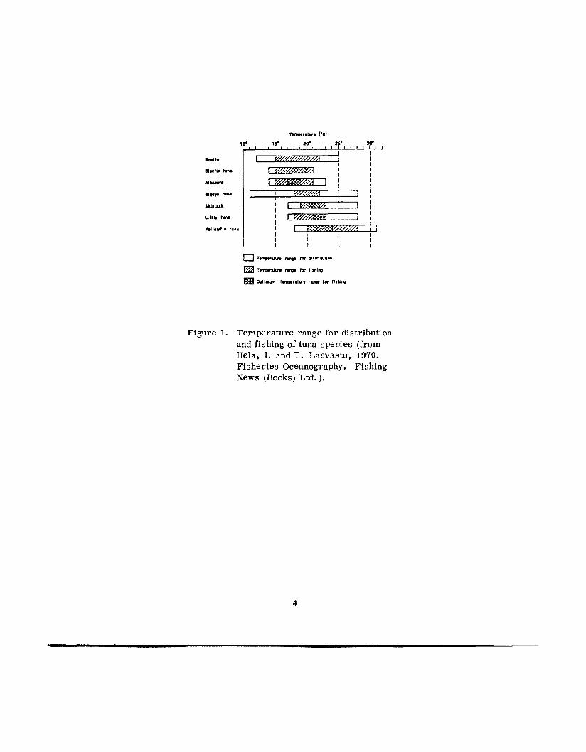
Figure 1. Temperature range for distribution and fishing of tuna species (from Hela, I. andT . Laevastu, 1970. Fisheries Oceanography. Fishing News (Books) Ltd.).
4

The eastern tropical Pacific is an important fishing region for tunas,
billfishes, and other fishes. For example, the annual U.S. tuna catch in 1971
from this region amounted to about 205,000 tons with an ex-vessel value of about
82 million U. S. dollars. Japan, and several Latin American countries also have
valuable tuna and other fisheries in the eastern tropical Pacific.
Information concerning the distribution of sea surface temperature,
especially delineations of regions of sharp temperature gradient which a r e called
sea surface temperature "frontsyy, is of great assistance to fishermen in locating
potentially good areas of fishing in the eastern tropical Pacific. Ocean tempera-
ture information is also needed for long range fishery planning, and population
models require ocean temperatures for predicting the location and availability
of the tunas in the eastern tropical Pacific. Also detailed sea surface temperature
data over the spawning grounds in the central Pacific a re essential i n estimating
the recruitment of future tuna stocks into ihe fishing grounds.
A plot of the number of sea surface temperature observations received
from surface vessels during a 1-week period from the eastern tropical Pacific
between 30" N to 5" S and the American coast and 140" W, and a contour plot of
the data a re shown in Figures 2 and 3, respectively. It is readily apparent that
the number of reports is limited, observations a re confined mainly to the shipping
lanes, and there a r e large areas where no observations a r e available. Also , be-
cause the data coverage is so sparse, it is not possible to locate the presence of
local sea surface temperature "fronts. 'I
5

0
w u)

c. .rl
td

A satellite equipped with the proper sensor may provide an ideal means
of monitoring and filling in the gaps of data in the distribution of sea surface tempera-
ture in the eastern tropicai Pacific and other ocean areas. With the ability of a polar-
orbiting satellite to repeatedly map the entire globe in 12-hour intervals, remote-
sensing of sea surface temperature from satellites could provide valuable synoptic
data to evaluate short-term variations in the distribution of sea surface temperature
and locate the presence of sea surface temperature "fronts. I '
Several satellites have been equipped with radiometers for making sea
surface temperature measurements using infrared techniques and under certain
conditions good results have been obtained. A chart showing the distribution of
s ea surface temperature based on measurements received from infrared sensors
aboard NOAA-1 is shown in Figure 4. The measurements shown in Figare 4 a r e
about 8" C above those reported by ships that were in the area at the same time the
observations were made by the satellite. The higher satellite temperatures a r e due
to radiometer calibration techniques. The chart has extremely useful applications
to fisheries because it shows small-scale sea surface temperature frontal structure
and by having some prior howledge about the temperature range and distribution
in the region and a few ship reports, numbers could be assigned to the isotherms
that would be more representative of the absolute temperatures.
There a r e limitations to infrared measurements of sea surface temperature
from satellites. The infrared 'radiaace method involves the assumption of a homogeneous,
8

9
non-transparent target that fills the radiometer field of view. This means that
severe contamination of the radiation measurements is introduced by clouds and
that this method of measuring sea surface temperature is limited to cloudless areas.
In order to determine whether clouds contaminate the radiation measurements,
simultaneous cloud photographs from the same satellite a r e necessary for proper
interpretation of the radiation data. In addition because of atmospheric attenuation
due to water vapor, which is non-uniformly distributed in space and time in the
atmosphere, proper corrections must be applied to satellite radiance measurements
in order to derive correct sea surface temperatures.
In spite of limitations, the information concerning the distribution of s ea
surface temperature derived from infrared measurements made from satellites can
be very useful to fisheries. However, the total potential of sea surface tempera-
ture measwemer,ts from satellites will not be realized by fisheries until senssrs
a r e developed which will give all-weather measurements. This will enable sea
surface temperature measurements to be macle from satellites in regions of u p elling,
where most of the Lvorld’s most important fishing areas a r e located, and other clourl-
covered areas which a r e important fishing grounds.
The development of microwave radiometry for remote measurements of
s ea surface temperature and other applications i s underway. Expcriments usir,g
airborne microwave sensors a re yielding encoaraging results and indicate that an
all-weather capability of n lexur ing sea surface temperature from space platforms
may be possible in the near FLi+..ii’F.
10

Ocean Color
It appears quite probable that spectral measurements of backscattered
light from the ocean surface will be made by satellites in the near future and
provide information on ocean color. The ability to measure ocean color with high
accuracy on a global basis by satellites may provide a new and useful tool for
locating areas of high biological productivity in the world ocean and lead to the
discovery of exploitable fishing grounds.
Ocean color can be used to delineate water masses, to trace currents,
and to determine the amounts of chlorophyll, pollutants, and other important
materials in the ocean. In addition ocean water color is also used by fishermen
in planning fishing strategy and in deciding where to fish.
Japanese tuna fishermen use water color measuring kits to find water of optimum
color before setting their lines. Salmon and albacore tuna fishermen fishing in
Pacific waters off the coast of North America often will use color ''frontstf as one
of the indicators of an a rea of potentially good fishing and many fishermen have
reported that high catches a r e often made in the vicinity of ocean color "fronts. I'
Water color, as an indicator of coastal currents may also assis t in the determina-
tion of migration paths of shrimps in the Gulf of Mexico and may be useful in
predicting their abundance and distribution. An oceanographic analysis of a
photograph taken during the GEMINI flight ser ies determined that the shrimp catch
in the Gulf of Mexico was highest in turbid water.
For example, some
11

Since chlorophyll is associated with living plants, spectral measurements
of chlorophyll concentration may be used as an index of the amount of phytoplankton
present in ocean water. Phytoplankton - microscopic, floating plants - form the
base of the marine food chain and regions of high phytoplankton abundance can sup-
port large poplations of herbivores and of successive links in the food chain,
including those which a r e of economic importance to man. Thus, chlorophyll may
be used to indicate the presence of potentially productive areas. Remote spectral
measurements of the proper wavelengths for estimating chlorophyll concentration
have been successful from low flying aircraft and have shown that increasing
amounts of chlorophyll a r e associated with a relative decrease in the blue portion
of the spectrum and an increase in the green. The absorption spectrum of a variety
of marine phytoplankton is shown in Figure 5.
Investigation is underway to extend the airborne instrumentation and
technique for measuring chlorophyll to satellite application.
atmospheric interference can be eliminated, or identified and allowed for,
spectrometric procedures from satellites for estimating chlorophyll concentration
appears probable.
Providing certain
Detection of Oceanic Boundaries
The detection of boundaries between water masses, currents, and other
oceanic discontinuities could have important applications to marine fisheries. The
migration routes followed by some pelagic fishes a r e tbmght to be related to
oceanographic boundaries. High biolcgical productivity is often associated with
12

1 .o
.9
.8
D 1 ATOM, Cyclotel/u sp. --- D I NO FL AGE L L AT E, Amphidium sp. - - - - - GREEN FLAG ELL AT E, Chlumyu'omonus. I \
NATURAL POPULATION - I '- - - -
.6
.5 W 0 -I Q
l- a 2 .4
O .3
.2
. I
0 4 .oo 500 600 700 800
WAVELENGTH, nm
Figure 5. Absorption spc~et1-n of n vnr i i t ty of mr,rinc p h ; . t ~ p l ~ ~ l l i t ~ ~ ~ (from Yentsch, C. S. , 1959. The influence of phyto- p lank ton pigments on the colour of sea w n t e r . Deep- Sea i<esenrcli 1: 1-9).
13

some types of oceanic boundaries, resulting in good feeding conditions for fishes.
Thus, areas of good fishing a r e often found in the vicinity of oceanic boundaries
and f ishernen spend much looking for them as a place to fish. In addition, certain
marine organisms, including some fishes, a r e limited to specific water masses
and the delineation of the water mass makes it possible to predict the distribution
of species confined to it.
Studies have shown that present satellite photography can provide informa-
tion useful in detecting pronounced oceanic discontinuities, essentially from eon-
trasting sea surface temperature conditions. The location of boundaries can be
inferred visually f rom photographic results from satellites by characteristic modi-
fications of existing cloud patterns a s caused by differential sea surface temperature
patterns and the concurrently induced local vertical circulations in the lower
atmosphere. However, this method is not highly accurate because the ocean
boundary and the cloud boundary do not always coincide, and may be displaced
several kilometers from each other. The method has been successful in delineating
the general location of boundaries of several major ocean currents including the
Gulf Stream, the Brazil and Falkland Current boundary, the boundary between the
Oyashio and Kuroshio Currents and the western boundary of the Agulhas Current.
Assuming successful sensor development for satellite application, the
simultaneous measurement of sea surface temperature and ocean color may be
used to locate oceanic boundaries on a global scale in the future. Simultaneous
measurement of these two properties from airborne sensors has been successfully
used to delineate oceanic boundaries.
14

Meteorological Aids
Weather conditions a r e extremely important to the safety and efficiency
of fishing operations and timely accurate weather forecasts a r e extremely important
to fishermen. Video photographs received from cameras pointed toward the earth
aboard orbiting and geostationary satellites a r e proving to be of great assistance to
meteorologists in making weather predictions. This has been especially true in those
instances where photographs from satellites a r e being used as an aid in making
marine weather forecasts for fishermen. For example, at the National Marine
Fisheries Service, Southwest Fisheries Center in La Jolla, California, an Automatic
Picture Transmission (APT) satellite receiving system is being used to monitor
conditions over the fishing grounds in the eastern tropical Pacific. The fishing
grounds extend westward from the principal shipping lanes along Central America,
and the APT salellite coverage makes it possible to infer, more accurately, weather
and sea conditions in areas where surface observations a re sparce.
photographs are extremely useful in locating areas of bad weather along the Inter-
tropical Convergence Zone and elsewhere, and in tracking the movements of tropical
storms and hurricanes. Also, when combined with surface ship observations, the
APT satellite photographs a re of great assistance in identifying areas of good
weather and probable improved fishing Conditions.
The AFT sateIlite
Based on the analysis of APT satellite photographs and surface observa-
tions from merchant and fishing vessels, two charts (Figures 6 and 7) containing
oceanographic and weather information tailored to fishermen’s needs a r e being
transmitted daily via radio facsimile broadcast to vessels on the fishing grounds in
15


c, u ld c 0

the eastern tropical Pacific. Sea state information including swell direction and
height, wind-wave height and, once each week, a 7-day sea surface temperature
analysis, is given on one chart. A second chart provides information on direction
and speed of surface winds, location and direction of movement of tropical s torms,
location of a reas of squalls and other inclement weather conditions, and location of
the Intertropical Convergence Zone. Within the very near future a weekly analysis
of thermocline depth and summaries of catch information wi l l be included on the
charts. Eventually the location of ocean surface temperature fronts indicated by
infrared temperature measurements made by orbiting satellites and received by the
APT installation at the Southwest Fisheries Center will be added to the charts.
The fishery-advisory service to tropical Pacific tuna fishermen is being
performed on an experimental basis a s a means of obtaining valuable environ-
mental data from fishing vessels and to provide fishermen with information which
may assis t them in making tactical fishing decisions.
facsimile recording equipment for copying the charts with the agreement that they
radio ashore environmental data. The environmental data collected by fishermen
are used in the preparation of the fishery-advisory charts and in research concerning
the development of fishery-forecasting techniques and methods for tropical tunas
currently underway at the Southwest Fisheries Center.
Fishermen are provided radio
Navigation and Locating Electronically Equipped Objects
Methods of navigation used by fishermen range from visual using the hwnan
eye unaided o r aided by instruments such as telescopes and sextants to highly
sophisticated electronic navigation systems such a s Loran and Omega. To my
18
knowledge no U. S. fishing vessels a r e equipped with satellite navigation equipment
and it is unlikely that U. S. fishing vessels will use satellite navigation equipment
in the near future because of high cost, complexity of operation, and difficulty of
obtaining service in small ports.
There is a great potential in fisheries research to use satellites for locating
electronically equipped objects and communication of information to shore. This
use of satellites could extend and improve geographic coverage of data and make
it possible to obtain data, particularly below the surface, on a real-time or synoptic
basis. It could also be used to track movements of fishes and other marine aaimals,
and improve our understanding of their migratioli patterns.
Summary
Remote sensing from satellite technoloo as applied to fisheries and
fisheries-oceanography is an emerging technique. Nevertheless, the degree to
which satellite remote sensing may assis t is becoming more positive. Measwe-
ment of sea surface temperature from orbiting satellites with infrared radiometry
has been demonstrated and the development of an all-weather thermal capability
using microwave radiometry is expected to provide basic scientific data for the
benefit of fisheries. Measurement of ocean color and sea state on a global scale
by satellites appears feasible. In addition it appears possible to monitor ocean
currents and boundaries and a reas of upwelling from earth orbiting satellites.
One of the greatest potential applications of remote sensing from satellites
to fisheries would be the simultaneous determination of sea surface temperature
19

and ocean color. Synoptic measurements of temperature and chlorophyll could
provide valuable information for locating potential areas of good fishing. For
example, fishery-oceanography studies off the Pacific coast of Baja California
have shown that tunas there feed almost exclusively on pelagic red crabs,
Pleuroncodes planipes. The red crabs are herbivores and are most abundant in
and adjacent to areas of localized upwelling where phytoplankton abundance is
highest. Thus remote sensing of chlorophyll could provide an indirect assessment
of the distribution and abundance of potential tuna forage and sea surface tempera-
ture measurements could be used to locate which of the forage-rich waters a re of
optimum temperature for tuna. Correlations between fish population and water
color and temperature have also been found in the region of the Columbia River
plume off the Pacific Northwest coast of the U.S. Color measurements in conjunc-
tion with temperature measurements could also be used to delineate water mass
boundaries and currents.
A strong point should be made, however, i f the information acquired by
sensors aboard satellites is to be usefidly applied to fisheries, each data acquisition
(sensor) package will require unique data management and analyses techniques and
equipment to convert the information to usable forms. Likewise an effective com-
munication network will be required to transmit the information to users.
May 19, 1972
20


![Sketchplore: Sketch and Explore with a Layout Optimiser · DesignScape [32] is a tool for assisting novice designers in creating graph-ical media. While our work, at first glance,](https://img.pdfslide.net/doc/110x75/60e58bde6b647119dd637f1a/sketchplore-sketch-and-explore-with-a-layout-optimiser-designscape-32-is-a-tool.jpg)