Embed Size (px)
Citation preview
VOL. 37, NO. 4 (DECEMBER 1984) P. 429.440 ARCTIC
In Search of a Sea Route tu Siberia, 1553-1619 T. ARMSTRONG*
INTRODUCTION
The discovery by western Europeans of the beginnings of a sea route along the north coast of Eurasia (Fig. 1) in the second half of the sixteenth century is quite well documented. Richard Hakluyt and his successor Samuel. Purchas. were the chief agents in preserving far us a series of accounts which allow us to discern the main outline of what went on. Through them we know quite well about the pioneering voyages (as far as the English were concerned) of Sir Hugh Willougliby to the Mm- man coast and of Richard Chancellor to the White Sea, in. 1553-54; of Steven Burrough, who reached the island of Vay- gach in 1556; of Arthur Pet and Charles Jackman, who also reached Vaygach, in 1580; and, through a Dutch source, of Willem Barents’s remarkable voyages. to Svalbard and Novaya Zemlya in 1594-1597, The cumulative effect of,these voyages was to make western ,Europeans aware that it was possible, but difficult, to sail eastward to the straits which separate what we. now call the Barents and the ,Kara seas. But none of the re- corded voyages was able to conquer the ice and to proceed far- ther eastward than that, and it was not until the eighteenth cen- tury that we read of specific voyages, this time Russian, deep into the Kara Sea.
That is the story as it comes across in the-histories of explor- ation. The whole truth, if we could ever ascertain it, would no doubt be a good deal more complex than that. The western European activity in these waters may have been more exten- sive than Hakluyt and Purchas allow; and more important, the locals, whether Norse, Finno-Ugrians, or Slavs, may have known a great deal more than their inalrility to write has per- mitted us,to take account of. My object in this paper is to see whether recent. research can help,is to raise the veil a little on some .of these possibiiities.
VOYAGES FROM WESTERN’EUROPE
There is a small untied end in the collection of documents printed by- Purchas (1625:Vol 3:804-806). He includes a report - it was one of the documents Purchas obtainedfram ,Hakluyt’s estate afterthe latter’s death - written in 1584 by some unnamed Russians in answer to a letter they had received from Antony Marsh, a chief factor of the Russia Company. Marsh. was evidently- trying to get these four. men .to make a trading voyage on.his.behalf from Arkhangel’sk to the River Ob’, which lies well within the Kara Sea; They expressed will- ingness, and it seems that they did later do so, travelling over-
land by the river system. But in their reply they made the inter- esting remark “Heretofore your people have bin at the said River of Obs mouth with a Ship, and there was made ship- wracke, and your people were slaine by the .Samoeds, which thought that they came to rob and subdue them.” The point is, who could these unfortunates have been? No English voyage to the Ob’ in the years immediately preceding 1584 is known.
A. E. Nordenskiold (1881 :229-2301, in one of the many historical asides in his narrative of his own magnificent pioneering voyage in the Vega through the Northeast Passage in 1878-79, picks up this remark. He says that while some think the shipwrecked party might have been that of Charles Jackman, the companion of Arthur Pet lost sight of by the con- sort vessel off Kolguyev in 1580, he (Nordenskiold) thinks it more likely to have been James Bassendine, another Eng- lishman whose instructions.to make a voyage to the Ob’ were printed by Hakluyt (1589:406-407, where the date is mistak- enly given as 1588 rather than 1568). But neither of these possibilities is at all likely. After Jackman had been lost sight of, he reappeared on the coast of Norway, where he wintered, and then went on to Iceland-the following year, there again disappearing, this time .finally.. Nordenskiold cannot have noticed this information, which is given in a note.appended by HaMuyt (1598-16OO:Voi. 1:453) to the account as retooldin his second edition:As for Bassendine, there is no certainty that his expedition ever. went at all, and even if it did, the “heretofore” of the Russians’ account would- have been 16 years before, which is somewhat unlikely.
Where then might the ship have come from? Among the English- there was:unquestionably a keen .desire to extend the sea route eastward, for reasons of trade. Marsh’s four .Rus- sians and Bassendine’s party. were two examples of the attempt to explore ‘what lay in the Kara. Sea.. These points will be . . discussed further. below;. While Hakluyt has indeed performed a great service .in..preserving .so many documents .relative- to north. Europe and especially to the Russia Company, it is clear that his coverage was not exhaustive: T., S . Willan, the histor- ian of. the Russia Company, shows that .not only did the Com- pany itself send a good many shipto the White Sea - averag- ing . I O a year in the early 1580s - but a number of English private traders were alsoqing to get, and getting, a foothold in Russia by t.his route. Some of these latter were former ser- vants of the Russia. company^ (Willan, 1956:129-156, 180-181). We have no detailed accounts .of my of these voyages, and even one that ended.in disaster might have at-
*Scott.Polar Research Institute, Lensfield Road, Cambridge CB2 .lER, England ~~ ~~~~

430 T. ARMSTRONG
FIG. I . Modern map of the north coast of Eurasia.
tracted no special attention, given the high .incidence of ship- wreck on the voyages we do .know about. .So there are many possibilities, and the right answer may never emerge.
One may note a final point. Purchas received the Marsh documents from Hakluyt, so one must assume that Hakluyt had some reason for not using them himself (the date, 1584, makes it probable that he could have placed them in either of .his editions). What, that reason was we cannot tell. Perhaps it was in some way connected with the fact that Marsh himself was not the most trustworthy of men. He got a bad name with the Company by trading in Muscovy on his own behalf, and incurring vast debts which the Moscow government forced the Company to honour (Willan, 1956: 196-198), and Hakluyt was rather close to the Company’s administration. But this isonly one of a number of possible reasons.
LOCAL SEAFARERS
Apart from .the incoming “discoverers” from the west, three local groups are likely to have .played a role in using
these waters for navigation: the local natives of the north, who in historical times must have been Samoyeds, today called Nentsy; the Norse; and the Slavs. The first two can be quickly dealt with.
The question of seafaring by northern natives at this period has been studied very little. Can it be said of the shores of the Kara Sea, as certainly can be said of large parts of the Cana- dian Arctic archipelago, that they were known to natives long before the first white man from the south came into the area? The answer is probably yes, but to the predecessors of the Nentsy rather than to the Nentsy themselves. The territory of the Nentsy extended from just east of the White Sea to the Yenisey and beyond. They had boats, but the types they were found to be .using when the Russians described them in the eighteenth and nineteenth centuries - small clinker-built hulls or dugout canoes - were borrowed from their neighbours or from the Russians. They often borrowed not only the design, but the boats themselves, preferring this to constructing their own. L. V. Khomich (1966142-45,75, IO), an authority in all- -these matters, makes no attempt to describe Nentsy seafaring as being important or far-ranging.

IN SEARCH OF A SEA ROUTE TO SIBERIA
But the Nentsy have probably occupied this coastal area, es- pecially around the lower Ob’ and Yenisey, only since about the time of the first western or Russian accounts. However, their predecessors, whose ethnic affiliation it is not possible to determine, unquestionably were hunters of sea mammals, es- pecially walrus. Archaeological sites at the northern end of Yamal provide the evidence, and have been dated to around loo0 A.D. (Chernetsov, 1935: 132). This people was probably assimilated by the Nentsy, so it is possible that the boats they used (of which no remains survive) were the easily portable skin boats described by Burrough on Vaygach in 1556 (Hakluyt, 1589:319). Thus one must suppose that there was coastal seafaring in the southwestern Kara Sea in the first millennium A.D. In the southeastern Barents Sea the same sort of evidence relates to an earlier period. The people living on the Murman coast in the first millenium B.C. evidently hunted seals (Okladnikov, 1959:36), which would have been found in the White Sea. How far afield these two groups sailed is not clear; it may not have been very far, since the sea mammals they were hunting were available close at hand (in the White Sea and the Ob’ estuary, for instance). But the coasts will surely have been familiar to them, and perhaps over a long dis- tance. No traces of native habitation have been found on Novaya Zemlya dating from before 1872, when Nentsy first settled there (Khomich, 1966: 17).
Norse hunters of seal and walrus were active in and around the Barents Sea from probably the ninth century, when Ottar mentions this, aS reported by Nansen (1911: Vol2: 135-147). Nansen goes on to suggest that they would have pursued these animals eastward and northward, and points to medieval Ice- landic geographical ideas which included a continuous coast- line from the White Sea (Bjarmeland) northward and westward to Greenland (Fig. 2). The most easterly part of the line would
FIG. 2. The conception of the northern and western lands and islands in Norse literature (Nansen, 191 1:Vol. 2:2).
43 1
be formed by the west coast of Novaya Zemlya, a region abounding in sea mammals, and this might therefore constitute evidence that it was known to Norsemen (Nansen, 191 1: Vol. 2:164-165). Walrus ivory traded in western Europe at that time is believed to have come from this area, but it is not clear whether the Norsemen were the hunters or the middlemen (Tegengren, 1962: 26, 33-36). However, by the sixteenth cen- tury there are no reports of Norse hunting voyages in these waters. Nansen (191 1:Vol. 2:166-181) postulates a gradual decline, brought about largely by political events in the in- tervening centuries.
There remain the Slavs, and in their case there is more solid evidence, both historical and archaeological, of quite consid- erable activity. Men of Novgorod reached the White Sea lit- toral by the twelfth century at the latest - and possibly a good deal earlier - and they moved eastward overland in the same century. It is not known when they may have started making sea voyages eastward along the coast. There is some evidence that the sea route as far as the Pechora was known in the early fourteenth century (Belov, 1956:34), but it is quite clear that by the middle of the sixteenth, when the first foreigners sailed beyond the White Sea, there were plenty of Slavs about - Muscovites as well as people from Novgorod.
Here we come back to Hakluyt and Purchas as our inform- ants, for there is a notable lack of Russian accounts of any sea voyages. Steven Burrough, who reached the Kara straits in August 1556, met a Russian walrus hunter called Loshak when he was anchored at a small island off the south coast of Novaya Zemlya. This Loshak said he had seen Burrough at Kola earlier in the season, and was very helpful, offering to take him to the Ob’. However, the ice prevented them, and Loshak left, along with two other boats of Russians from the Pechora (Hakluyt, 1589:318-319). Sometime between 1558 and 1567 Richard Johnson, a Russia Company employee, collected a traveller’s tale from a Russian called Tovtigin about the Ob’ river and the savage Samoyeds who lived on and beyond it (Hakluyt, 1589:389). The four Russians with whom Antony Marsh was in contact in 1584 offered to make the journey to the Ob’ by sea, if Marsh wished, saying they would travel by way of Vaygach, Novaya Zemlya, and “the land of Mat- pheove” (taken by C. T. Beke (De Veer, 1876:87-88) to mean the north island of Novaya Zemlya, thus implying a passage through the strait of Matochkin Shar; but much more likely to mean Matveyev Ostrov in the southeastern Barents Sea, for it was said to be “but a small matter to sayle” by that route from Vaygach to the mouth of the Ob’).
If we move on another 25 years, more evidence appears. Purchas reports a number of relevant matters. He has the ac- count by William Gordon of Hull of his voyage to the Pechora in 161 1, and Gordon records meeting 10 boats of Russian wal- rus hunters bound from Pinega on the White Sea to Novaya Zemlya (Purchas, 1625:Vol. 3531). In the Pechora estuary he met 28 more boats, most of them bound from the White Sea to Mangazeya on the east side of the Ob’ estuary; this flotilla, said his companion William Pursglove, carried over 200 men (Purchas, 1625:Vol. 3547). Gordon refers shortly afterwards to 30 boats at the Pechora (Purchas, 1625:Vol. 3:534), but it is

432
not clear whether these overlap with the others he mentioned earlier. Josias Logan, who was on the same voyage and was left to winter over at Pustozersk on the Pechora, talked to a Russian who described to him the sea route to the Ob’ (Pur- chas, 1625:Vol. 3543): it involved sailing through Yugorskiy Shar to Yamal, and then apparently right round that peninsula and into the Ob’ estuary beyond it. A more usual route crossed Yamal by rivers and portage, as is described by Richard Finch of the same voyage (Purchas, 1625:Vol. 3539).
This body of evidence, as well as others, also contains in- dications of voyages beyond the Ob’. The Dutchman Isaac Massa’s Korr Verhael, published by Hessel Gerritsz in Amsterdam in 1612, mentions an apparently successful voyage from the Ob’ to the Yenisey River under the command of one Luka. Translations of this may be found in Purchas (1625:Vol. 3522-529), in Witsen (1705:732-735), and a fuller one in Baddeley (1919:Vol. 2:3-12). Baddeley believes the voyage took place between 1605 and 161 1. Massa notes that it was a pity the Dutch had not up to then succeeded in get-
< ting beyond Vaygach (despite Barents’s magnificent voyages in the 159Os), for if they had stayed in the Pechora region,.they would surely have been shown the way by friendly Russians. Massa’s account mentions the Tungus (“Tingoesy”), and the rivers Yenisey and Pyasina (“Pesida”), indicating knowledge of country far beyond the Ob’ - but a sea link with these areas is not specifically mentioned, and it is much more likely that inland waterways were the routes used. Purchas (1625:Vol. 3: 530) prints an account by an anonymous Russian, translated by Richard Finch and brought to England probably in 1612 by John Merrick of the Russia Company, in which more place- names east of the Ob’ are mentioned, including the Kheta river (“Geta”), where Russians are said to have lived for six years. But again, inland routes are the likeliest means of access to these places. Logan is reported (Purchas, 1625:Vol. 3:544) to have been told by a local about the Pyasina (“Peasida”, but the word also connoted the whole peninsula of Taymyr) and the Khatanga (“Catonga”) - this last the furthest east of all the places mentioned at this time. Pursglove’s account (Pur- chas, 1625:Vol. 3551) confirms the story, calling that river the Catowga. The Kheta and the Khatanga flow into the Laptev Sea.
The apparent increase in activity at about the turnof the cen- tury may have a real basis in fact. It was at that time that the new town of Mangazeya was founded on the Taz River, a right tributary of the Ob’ estuary, and it was reached from European Russia either by inland waterways or by sea. The inland routes do not concern us here, but the sea route is highly relevant. It followed the course already mentioned: from the White Sea by way of the Pechora estuary to the island of Vaygach, which might be passed on either side but generally on the south, through Yugorskiy Shar; thence coasting round Baydaratskaya Guba, or perhaps crossing it, until reaching the river then called Mutnaya which leads across the peninsula of Yamal, by way of a system of lakes and a portage, to the Ob’ estuarjr; then turning south up the Estuary, and into the estuary of the Taz. I believe that occasiohally ships would have followed the coast all the way, not taking advantage of the portage section,
T. ARMSTRONG
and would have entered the Ob’ estuary at its mouth. The reason for the Russian advance into this area was the
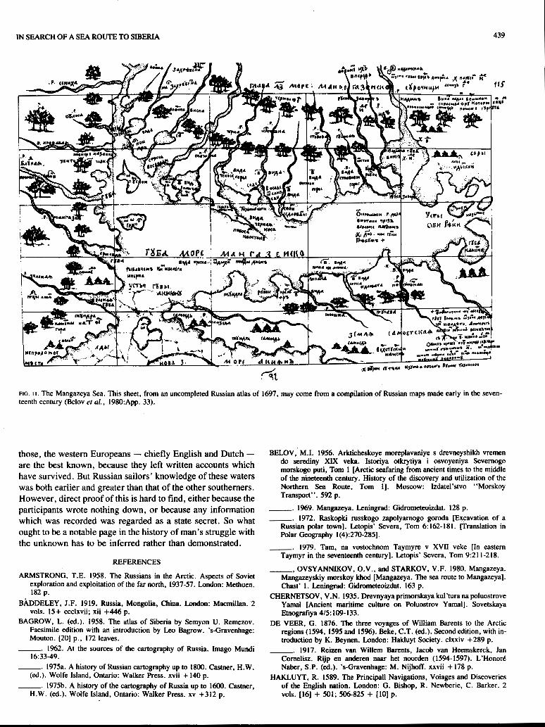
pursuit of fur-bearing animals such as the sable. The district was called Mangazeya - a name derived from the group of Samoyeds who lived as nomads thereabouts, and rendered in the early English accounts as Molgomzay, Molgomzaia, Mon- gunzea, Mongozey, and other variants. Much research has been done in the last decade or so on the town of Mangazeya, including a full-scale archaeological excavation. The driving force behind this has been the Soviet historian M.I. Belov. The town was founded in 1 6 0 1 , although the first foundations of one building are dated at 1594, implying that it was from a time when there was no town there but perhaps just a hunting post (Belov, 1972:176). Another post in the area, Tazovskiy Gorodok, has been dated by dendrochronology at 1572 (Belov, 1979:211). The town was in its time the most ad- vanced outpost of Muscovite power in the northeast, and therefore served as base for parties exploiting furs in not only the immediate vicinity (itself an area probably as big as England) but further to the east and north. The onward routes were chiefly by river - there was a relatively easy passage up the Taz and over a portage to the Yenisey - but the sea was also used. The type of ship most frequently used for seagoing voyages was the koch, which had a cargo capacity of 40 tomes and carried a crew of 10-15. Belov (1972: 179) reckons 25-30 of these visited Mangazeya annually. The first major sea trip by Mangazeya merchants and hunters to the base of the Taymyr peninsula took place in 1610 (Belov, 1979:212). An even more recent publication by Belov et al. (1980: 108-127) deals in considerable detail with the sea approaches to Mangazeya. But there is no evidence of any voyage at this period reaching further up the Taymyr coast than the Pyasina river.
Most of the seagoing traffic to and from Mangazeya would have been Russian, of course. But it may be inferred that for- eign ships did also travel that way, because in 1619 Tsar Mik- hail Fedorovich issued a decree forbidding use of the sea route to Mangazeya, and the likely reason for this is that foreign traders were avoiding Russian customs by so doing. Belov (1956: 1 1 1) has recorded his suspicions that there was even a threat to Russian sovereignty over these remote regions. This is not wholly impossible, for there is good evidence that James I of England, acting through the Russia Company, had designs on north Russian territory in 1612 (Lubimenko, 1914; see also Konovalov, 1950:69-70 for further mention of the area in correspondence between the two monarchs).
There is one other important piece of evidence to be taken into account in trying to establish the sequence of early voyages beyond the Yenisey. The remains of human habitation were found in the early 1940s at two places some 80 km apart on the northeast coast of Taymyr - at Zaliv Simsa and Ostrov Faddeya. The objects found included over 3000 coins, and their analysis made it clear that this was a hunting and trading party which had started its journey in Muscovy (Okladnikov, 1948). It is evident from the objects found, and from the loca- tion, which was far from any river and in part on an island, that the party must have arrived by sea. When, and which way

IN SEARCH OF A SEA ROUTE TO SIBERIA 433
were they going? The date of collection of the coins suggested by the coin expert I. G. Spasskiy was 1617. There are no reports of anyone navigating off the Taymyr coast as early as this. The balance of probabilities had been thought to be that the party was travelling eastward, probably from Mangazeya, and was in search of the fur-bearers and the natives who caught them in one of the river basins draining into the Laptev Sea. The argument against a westward voyage from the Laptev Sea is mainly that there was no Russian base in the Lena valley at that date from which such an evidently elaborate expedition might have been launched (Armstrong, 1958: 134-138). But other possibilities exist. We have noted earlier the mention of the Kheta and Khatanga rivers in English reports of 161 1 and 1612. Surely, then, the river and portage route across the southern base of Taymyr was well known and used by Rus-
sians by those dates, and so might have been used by the party whose remains have been found. Belov (1969: 107-1 16), how- ever, advances another view. He believes Spasskiy’s date could be considerably too early, and, finding it odd that neither the departure of such an important party nor its disap- pearance is mentioned in the surviving literature, he seeks to identify it with a voyage by a party under Ivan Tolstoukhov, who is believed to have sailed eastward along the coast of Taymyr in 1686-87. Tolstoukhov himself evidently died at the mouth of the Pyasina, for in 1738 Fedor Minin of the Great Northern Expedition found there a cross marked with his name. Furthermore, Belov rules out a Laptev Sea start by stating that use of the sea route out of Lena to the Anabar (a sector the lost party would presumably have had to travel) was forbidden by the voyevoda of Yakutsk in the 1640s. We have

I 434
T. ARMSTRONG
FIG. 4. The Hirsvogel-Herberstein map of Russia, 1546 (Herberstein, 1851-52).
FIG. 5 . William Burrough’s map of north Scandinavia and north Russia, after 1556 (Jenkinson, 1886).

IN SEARCH OF A SEA ROUTE TO SIBERIA 435
FIG. 6. Ortelius’s edition of Anthony Jenkinson’s map of Russia, 1570 (Bagrow, 1975b:95).
not sufficient evidence on which to decide whether the voyage was made in the first or the last quarter of the seventeenth cen- tury: but it was surely within that bracket, and was probably a pioneer effort (the first certain knowledge of a ship traversing those waters was Nordenskiold’s Vega in 1878-79). My own preference is for the.earlier date, because the prohibitory edict of 16 19 would help account for the virtual absence of other traces of human parries on these shores (which have now been fairly frequently visited).
THE CARTOGRAPHIC RECORD
Some indications of discovery, but not necessarily very direct ones, may be. gleaned from a study of the maps. of the period. The men who made the discoveries by no means always made the maps. The new information was commonly given to a professional mapmaker, who incorporated it on his
next map of that part of the world (or indeed of the world as a whole). So it is worth studying the maps of the period in order to see the way in which the coastline to the east of the Kara straits is represented.
Two of the earliest maps to show the Ob’ river were those of Anton Wied, a Danziger who got his Russian information from a fugitive boyar called Ivan Lyatskiy (Fig. 3); and of Augustin Hit-svogel, who worked OR the materials brought back from Muscovy by the Ambassador of ,the Holy Roman Empire, Sigismund von Herberstein (Fig. 4). These two maps first appeared in 1542 and 1546 (Bagrow, 1975b:64-72), respectively. Neither shows the sea (this being off the edge of the map), but Wied shows a broadening of the river which we must take to be the estuary. Wied’s delineation was copied by Sebastian Münster on a map of Russia in his Cosrnosgruphiu of 1544, and later by Mercator.
The entrance to the Kara Sea first appears, appropriately, in

436 T. ARMSTRONG
a map by William Burrough, brother of Steven and participant on the voyage of 1556 in Searchthrifr. This map (Fig. 5 ) , reproduced .in Morgan and Coote’s edition of the Elizabethan Anthony Jenkinson’s travels, shows the coast from Norway to the island of Vaygach. Jenkinson, though he never went east. of the Wh.ite Sea himself, produced an excellent map of Russia on which that region is shown. The map (Fig. 6), evidently made in the 1560s, is lost, but is known from tw printed editions: in Ortelius’s Theatrum orbis terrarum ‘of 1570 and- in G. de Jode’s Speculum orbis termrum of 1578. They show a corner of the Kara Sea beyond Vaygach, as far as the Ob’ estuary. But from the lack of any-thing resembling the large peninsula of Yamal on the west side of the estuary, one must suppose that Jenkinson. was simply extrapolating from Burrough, and had no contact with any Russians who knew the area.
One might expect the next advance to derive from Barents’s voyages. They did of course lead to a much fuller and more ac- curate delineation,of Novaya Zemlya (Fig. 7), but the coast between Vaygach and the Ob’ remained as unreal as it was in .Jenkinson - from whom ‘it. was no ,doubt copied (Bagrow, 1975b: 103-108). Similarly Mercator’s last map of Russia, which appeared in 1595 after his death, adds little in that area
‘except an exaggerated Ob’ estuary (Bagrow, 1975b: 114). Ger- rit De Veer did, however, produce a remarkably accurate large-scale map.of Yugorskiy Shar (Fig. 8).
The real advance came a little later, with a map produced in 1611 by Isaac Massa, the Dutchman already mentioned. Massa had lived i.n Russia from. 1601 to 1609, and knew his way around, at any rate in ,Moscow. His map (Fig. 9) is the first to show the peninsula of Yamal, together. with. the river, lake, and portage route across it; and, most interestingly, Belyy Ostrov (“Boloi ostorf”)i the island off its northern tip. The coast beyond is shown rather less accurately, but it in- cludes the Yenisey estuary and even the. Pyasina. This infor- mation was obtained by Massa from a Russian friend whose brother had been in those waters, and who gave him, at great personal risk, a map compiled .on the ,basis of the brother’s descriptions. The penalty for discovery of this teak, says Massa, would have been. death (Baddeley, 1919:Vol. 2: 11). The presence of Belyy Ostrov, not mentioned. in any of the earlier accounts or maps, must mean that it was already quite familiar to Russians.
The earliest surviving Russian map. of the area is. the so- called Godunov map, drawn up for the voyevoda of Tobol’sk,

I 1 IN SEARCH OF A SEA ROUTE TO SIBERIA ,437

438 T. ARMSTRONG
FIG. io. The Godunov map of Siberia - probably the first Russian map of the area. This version dates from about 1668. North is at the bottom (Bagrow, 1975a:25).
P. I. Godunov, about 1668 (Fig. 10). This is known to us from various copies, both Russian (made officially by the carto- grapher S . U. Remezov) and Swedish (made highly unoffici- ally by persons attached to Swedish embassies to Moscow) (Bagrow, 1975a:22-30). They relate, as we can see, to a cruder category of map-making, but they contain plenty of in- formation. The fuller cover beyond the Yenisey river reflects the Russian advance across north Asia which took place-in the middle years of the seventeenth century, and takes us out of the time frame of this paper. It may be, however, that another surviving Russian map predates the Godunov map. The same Remezov prepared, but never completed, an atlas of Siberia called Khorograjkheskaya chertezhnaya kniga. This was in 1697, and the collection of maps was ultimately published by the cartographic historian Bagrow (1958). In it there is a map (sheet 115) of the “Mangazeya Sea” [Guba More Mangazey-
sko], showing the whole of the Ob’ and Taz estuaries and much of the drainage into them (Fig. 11). Belov believes this sheet to have been a fragment of a much earlier compilation of Russian maps called Bd’shoy chertezh, which was destroyed in a fire in Moscow in 1626. He dates it at 1601 -1603, on the grounds that events known to have occurred in 1601 are recorded on-it (Belov et al., 1980: 113-1 16). That argument is not strong, but it does seem possible that this sheet is earlier than the Godunov map.
CONCLUSION
Between one and three thousand years ago, human beings evidently hunted in those parts of the Barents and Kara seas that we have been concerned with, probably keeping mainly to coastal waters. But this was all finished by the time the first voyagers from the west and the south came into the area. Of
IN SEARCH OF A SEA ROUTE TO s m m 439
FIG. I I . The Mangazeya Sea. This sheet, from an uncompleted Russian atlas of 1697, may come from a compilation of Russian maps made early in the seven- teenth century (Belov e? al., 1980:App. 33).
those, the western Europeans - chiefly English and Dutch - are the best known, because they left written accounts which have survived. But Russian sailors’ knowledge of these waters was both earlier and greater than that of the other southerners. However, direct proof of this is hard to find, either because the participants wrote nothing down, or because any information which was recorded was regarded as a state secret. So what ought to be a notable page in the history of man’s struggle with the unknown has to be inferred rather than demonstrated.
REFERENCES
ARMSTRONG, T.E. 1958. The Russians in the Arctic. Aspects of Soviet exploration and exploitation of the far north, 1937-57. London: Methuen. 182 p.
BhDELEY, J.F. 1919. Russia, Mongolia, China. London: Macmillan. 2 vols. 15+ ccclxvii; xii +446 p.
BAGROW, L. (ed.). 1958. The atlas of Siberia by Semyon U. Remezov. Facsimile edition with an introduction by Leo Bagrow. ’s-Gravenhage: Mouton. [20] p., 172 leaves.
-. 1962. At the sources of the cartography of Russia. Imago Mundi 16:33-49.
-. 1975a. A history of Russian cartography up to 1 8 0 0 . Castner, H.W. (ed.). Wolfe Island, Ontario: Walker Press. xvii + 140 p.
-. 1975b. A history of the cartography of Russia up to 1600. Castner, H.W. (4 . ) . Wolfe Island, Ontario: Walker Press. xv +312 p.
BELOV,’ M.I. 1956. Arkticheskoye moreplavaniye s drevneyshikh vremen do serediny XIX veka. Istoriya otkrytiya i osvoyeniya Severnogo morskogo puti, Tom 1 [Arctic seafaring from ancient times to the middle of the nineteenth century. History of the discovery and utilization of the Northern Sea Route, Tom I]. Moscow: Izdatel’stvo “Morskoy Transport”. 592 p.
-. 1969. Mangazcya. Leningrad: Gidrometeoizdat. 128 p. -. 1972. Raskopki russkogo zapolyarnogo goroda [Excavation of a
Russian polar town]. Letopis’ Severa, Tom 6:162-181. [Translation in Polar Geography 1(4):270-2851.
-. 1979. Tam, na vostochnom Taymyre v XVII veke [In eastern Taymyr in the seventeenth century]. Letopis’ Severa, Tom 9:211-218.
___, OVSYANNIKOV, O.V., and STARKOV, V.F. 1980. Mangazeya. Mangazeyskiy morskoy khod [Mangazeya. The sea route to Mangazeya]. Chast’ I . Leningrad: Gidrometeoizdat. 163 p.
CHERNETSOV, V.N. 1935. Drevnyaya primorskaya kul’tura na poluostrove Yamal [Ancient maritime culture on Poluostrov Yamal]. Sovetskaya Etnografiya 4/5: 109- 133.
DE VEER, G . 1876. The three voyages of William Barents to the Arctic regions (1594, I595 and 1596). Beke, C.T. (ed.). Second edition, with in- troduction by K. Beynen. London: Hakluyt Society. clxxiv +289 p.
-. 1917. Reizen van Willem Barents, Jacob van Heemskerck, Jan Cornelisz. Rijp en anderen naar het noorden (1594-1597). L’Honor6 Naber, S.P. (4.). ‘s-Gravenhage: M. Nijhoff. xxvii + 178 p.
HAKLUYT, R. 1589. The Principal1 Navigations, Voiages and Discoveries of the English nation. London: G . Bishop, R. Newberie, C. Barker. 2 VOIS. [16] + 501; 506-825 + [lo] p.
440 T. ARMSTRONG
-. 1598-1600. The Principal Navigations, Voiages, TrafEques and Discoveries of the English nation. London: G. Bishop, R. Newberie, R. Barker. 3 vols. [24] + 619; [la] + 312 + 204; [16] + 868 p.
JENKINSON, A. et al. 1886. Early voyages and travels to Russia and Persia by Anthony Jenkinson and other Englishmen, with some account of the first intercourse of the English with Russia and Central Asia by way of the Caspian Sea. Morgan, E.D. and Coote, C.H. (eds.). London: Hakluyt Society. clxii + 176 p.
KHOMICH, L.V. 1966. Nentsy. Istorikoetnograficheskiye ocherki [The Nentsy. Historical and enthnographic outlines]. Leningrad: Izdatel’stvo “Nauka”. 330 p.
KONOVALOV, S. 1950. Anglo-Russian relations, 1617-18. Oxford Slavonic
LUBIMENKO, I. 1914. A project for the acquisition of Russia by James 1. English Historical Review 24246-256.
NANSEN, F. 1911. In Norhrn Mists. Arctic Exploration in Early Times. London: Heinemann. 2 vols. xi + 384; 416 p.
NORDENSKIOLD, A.E. 1881. The voyage of the Vega round Asia and Europe, with a historical review of previous journeys along the north coast of the Old World. Leslie, A. (transl.). London: Macmillan. 2 vols. xix + 482; xxv + 524 p.
OKLADNIKOV, A.P. 1948. Russkiye polyarnyye morekhody XVII veka u beregov Taymyra [Russian polar seafarers of the seventeenth century on the coasts of Taymyr]. Moscow, Leningrad: Izdatel’stvo Glavsevmorputi. 157 p.
Papers 1:64-103.
-. 1959. Archaeology of the Soviet Arctic. Acta Arctica 12:35-45. PURCHAS, S. 1625. Hakluytus Posthumus or Purchas his Pilgrimes.
Contayning a History of the World, in Sea voyages, and land-travells, by Englishmen and others. London: H. Fetherston. 4 vols. [34] + 186 +[8]
1141-1973 + [39]. [Maclehose published a 20-vol. edition at Glasgow in
TEGENGREN, H. 1%2. Valrosstanden i viirldshm$eln [walrus tusks in world trade]. Nordenskicild-Samfundets Shifter, Arg. 22:3-37.
von HERBERSTEIN, S. 1851-52. Notes upon Russia, being a translation of the earliest account of that country, entitled Rerum Muscoviticamm commentarii, by the Baron Sigismund von Herberstein, ambassador from the court of Germany to the grand prince Vasiley Ivanovich, in the years 1517 and 1526. Major, R.H. (ed.). London: Hakluyt Society. 2 vols. clxii + 116; iv + 266p.
WILLAN, T.S. 1956. The early history of the Russia Company, 1553-1603. Manchester: University Press. x + 295 p.
WITSEN, N. 1705. Noord en &st Tartaryen [North and east Tartary]. Amsterdam: M. Schalekamp. xxv + 986 p.
+ 748 + [21]; [4] + 749-1860 + [35]; [I21 + 1140 + [68]; [6] + 1905-07.1