Embed Size (px)
Citation preview

TAT-0-EV-06001-CO-RP-0005
IN THE MATTER OF The Resource Management Act 1991 AND IN THE MATTER OF applications for resource consents in relation to Te
Ahu a Turanga; Manawatū Tararua Highway Project BY NEW ZEALAND TRANSPORT AGENCY
Applicant
TE AHU A TURANGA: TECHNICAL ASSESSMENT F
TERRESTRIAL ECOLOGY

TAT-0-EV-06001-CO-RP-0005 Page 2
TABLE OF CONTENTS
INTRODUCTION ...................................................................................................... 3 SUMMARY AND KEY CONCLUSIONS ................................................................. 11 REPORT STRUCTURE ......................................................................................... 14 PROJECT DESCRIPTION ..................................................................................... 15 SITE DESCRIPTION (TERRESTRIAL ECOLOGY OVERVIEW) .......................... 15 ASSESSMENT OF EFFECTS METHODOLOGY .................................................. 18 TERRESTRIAL AND WETLAND ECOLOGICAL CHARACTERISTICS ................ 27 ASSESSMENT OF 'ECOLOGICAL VALUES' ........................................................ 37 ASSESSMENT OF STATUTORY SIGNIFICANCE OF TERRESTRIAL HABITATS ............................................................................................................................... 54 MAGNITUDE OF EFFECTS' ASSESSMENT ........................................................ 58 MEASURES TO ADDRESS RESIDUAL EFFECTS THAT CANNOT BE AVOIDED OR MINIMISED .................................................................................................... 101 SUMMARY AND CONCLUSION ......................................................................... 111 APPENDIX F.1: ASSESSMENT OF EFFECTS ON BATS .................................. 113 APPENDIX F.2: ASSESSMENT OF EFFECTS ON TERRESTRIAL INVERTEBRATES ............................................................................................... 114 APPENDIX F.3: VEGETATION SURVEY METHODOLOGY AND RESULTS..... 115 APPENDIX F.4: AVIFAUNA SURVEY METHODOLOGY .................................... 140 (REFER TO TABLE F.6.2 IN APPENDIX F.6 FOR RESULTS) ........................... 140 APPENDIX F.5: ECOLOGICAL IMPACT ASSESSMENT GUIDELINES ............. 141 APPENDIX F.6: TERRESTRIAL AND WETLAND ECOLOGICAL VALUES ....... 146 APPENDIX F.7: PHOTOGRAPHIC EXAMPLES OF KEY CHANGES IN HABITAT CLASSIFICATIONS FROM NOR ASSESSMENT ............................................... 158

TAT-0-EV-06001-CO-RP-0005
INTRODUCTION
1. My name is Matthew James Baber. I hold the position of Principal Ecologist/
Director at Alliance Ecology Ltd, which I have held since May 2019. I also
hold the position of independent contractor for Tonkin + Taylor Ltd ("T+T").
Qualifications and experience
2. My previous employment and associated positions include:
(a) Tonkin + Taylor (2011 - 2019)
(i) Technical Director/Project Director (Ecology) (2019)
(ii) Discipline Manager (Ecology)/Principal Ecologist (2017-2018)
(iii) Team Leader Ecology/Principal Ecologist (2016)
(iv) Principal Ecologist (2014 - 2015)
(v) Senior Ecologist (2011 - 2014)
(b) Auckland Council (2010 - 2011): Team Leader Biodiversity
(c) Auckland Regional Council (2007 - 2010): Natural Heritage Scientist
(d) Ecovision (2004 - 2007): Ecologist/Director
(e) Postdoctoral Research Scientist, University of New Hampshire (2001 -
2004).
3. I hold the qualifications of Bachelor of Science (Zoology) from Otago
University, Master of Science (Hons) (Conservation Ecology) from Auckland
University, and Doctor of Philosophy (Ecology) from Florida International
University (Miami, Florida, USA).
4. I have completed the Ministry for the Environment Making Good Decisions
course (September 2019) and have been certified as an Independent
Hearing Commissioner.
5. I am on the approved panel of technical expert service providers for the
Environmental Protection Authority (EPA) as a provider of technical services
(in terrestrial ecology) for the assessment of resource consent applications
lodged with the EPA or called in by the Minister.

TAT-0-EV-06001-CO-RP-0005 Page 4
6. I am a member of the New Zealand Ecological Society, the Environmental
Institute of Australia and New Zealand (EIANZ) and I am a Department of
Conservation permitted herpetologist.
7. I have 19 years' experience as a professional ecologist. My work experience
includes assessments of environmental effects; input into statutory and
non -statutory policies, plans, and strategies; and the design and
implementation of mitigation/biodiversity offset packages, ecological
restoration initiatives, and biodiversity research and monitoring programmes.
I have worked in a variety of forest, riparian, wetland, and coastal ecosystem
types and on a diversity of taxa in New Zealand and abroad. I have authored
more than 20 international and national peer-reviewed scientific publications
and numerous technical reports on the above subject matters. I have led or
been involved in the assessment of ecological effects for a number of large
infra-structure projects including appearance as an expert witness for various
council hearings, environment court hearings and a Board of Inquiry.
Specifically, I have:
(a) Appeared as the expert witness on behalf of Auckland Council for the
Onehunga Foreshore Rehabilitation Hearings on terrestrial ecology and
coastal bird matters (2011);
(b) Appeared as the expert witness for the Department of Conservation on
terrestrial ecology and coastal bird matters for the Transmission Gully
Motorway Board of Inquiry (2011);
(c) Appeared as the expert witness for the Department of Conservation on
terrestrial, wetland and freshwater ecology (excluding long-tailed bats)
for the joint hearing for the Hamilton Section of the Waikato
Expressway Resource Consent Application and the East-West
Tamahere Link Notice of Requirement ("NOR") and for the Southern
Links Section of the Waikato Expressway Resource Consent
application (2014);
(d) Appeared as an expert witness on behalf of the West Coast Regional
Council and Buller District Council on terrestrial ecology matters for the
Mt William North mine (Solid Energy) hearing (2014);
(e) Appeared as an expert witness before Council Hearings and
Environment Court in relation to consent applications for quarrying and

TAT-0-EV-06001-CO-RP-0005 Page 5
residential developments in terrestrial and coastal environments
(Various);
(f) Led the assessment of ecological effects on the terrestrial and wetland
ecology components of the Huntly Section of the Waikato Expressway
on behalf of the New Zealand Transport Agency (2014);
(g) Led the development and implementation of ecological management
plans for Puhoi to Warkworth Road of National Significance for NX2 on
behalf of the New Zealand Transport Agency (2015 - 2016);
(h) Led the ecology inputs during the Multi-Criteria Assessment ("MCA")
phase for the Mt Messenger SH3 Project (2017) on behalf of the New
Zealand Transport Agency;
(i) Led the terrestrial ecology inputs for the assessment of effects for the
Auckland Regional Landfill Project for Waste Management New
Zealand, including the development of offsetting and compensation
models (2019 - ongoing);
(j) Led and managed ecological input into the resource consent process,
policy review, and the development and implementation of biodiversity
management initiatives for Auckland Council (2010 - 2011); and
(k) Co-authored the Peacocke's Structure Plan Area Effects Management
Framework for Hamilton City Council, which includes the application of
offset and compensation models.
8. I have provided advice on terrestrial ecology matters related to the proposed
Te Ahu a Turanga Project ("the Project") to the Alliance, and ultimately the
NZ Transport Agency, since January 2020.
9. My contributions include:
(a) Preparing an assessment of the Project's effects on terrestrial
vegetation and fauna based on the now-proposed alignment and level
of design; and
(b) Assistance with the preparation and review of the Ecological
Management Plan ("EMP") proposed for the Project, which includes the
following subsidiary plans: Vegetation Clearance Management Plan,
Lizard Management Plan, Avifauna Management Plan, and Residual
Effects Management Plan.

TAT-0-EV-06001-CO-RP-0005 Page 6
Code of conduct
10. I confirm that I have read the Code of Conduct for expert witnesses
contained in the Environment Court Practice Note 2014. This assessment
has been prepared in compliance with that Code, as if it were evidence being
given in Environment Court proceedings. In particular, unless I state
otherwise, this assessment is within my area of expertise and I have not
omitted to consider material facts known to me that might alter or detract
from the opinions I express.
Purpose and scope of assessment
11. The purpose of this evidence is to assess the effects of the Project on
terrestrial and wetland habitat types and associated flora and fauna to inform
the resource consent applications for the Project 'main works' as detailed in
the Design Construction Report ("DCR") (provided in Volume II of the
application materials). This includes:
(a) Characterisation and assessment of terrestrial and wetland habitat
types and associated flora and fauna within the Project 'main works'
footprint and immediate surrounds;
(b) An assessment of the potential for adverse effects on
vegetation/habitat types, bird and lizard values after measures to avoid
or minimise adverse effects have been undertaken; and
(c) Provision of proposed habitat restoration and enhancement measures
for addressing residual effects that cannot be avoided or minimised.
12. In undertaking this assessment I have reviewed the description of the
existing environment as set out in the Transport Agency's Technical
Assessment 6: Terrestrial Ecology, prepared by Dr Adam Forbes and lodged
with the Notices of Requirement ("NoRs") for designations for the Project
("Technical Assessment 6"). That description remains applicable to the
resource consent applications, subject to small adjustments to the description
of 'Ecological Values' (discussed in this report) following the change to the
Project alignment and additional survey work, and to include areas of work
that are located beyond the proposed designation boundaries (notably spoil
sites).
13. The Tonkin & Taylor ("T+T") ecology team has verified the information
presented by the Transport Agency and its NoR experts through site visits,

TAT-0-EV-06001-CO-RP-0005 Page 7
additional survey data and a detailed assessment of the potential effects of
the Project on terrestrial ecology with respect to long-tailed bats (refer to the
Assessment of Effects on Bats Report prepared by Ms Cummings, included
at APPENDIX F.1) and invertebrates (refer to Assessment of Effects on
Terrestrial Invertebrates Report prepared by Dr Curry at APPENDIX F.2). In
this assessment I present (in summary form) the results in respect of bats
and invertebrates as set out by Ms Cummings and Dr Curry. That said, I
have discussed these findings with Ms Cummings and Dr Curry and I have
undertaken site walkovers to verify these assessments myself.
14. I have consulted with Dr Forbes to verify my assessment and conclusions
with respect to the 'Level of Effects' assessment and residual effects
management.
15. In this evidence, I highlight instances where my assessment of the potential
effects of the Project differs from the assessment at the NoR stage. In most
instances those differences result from additional or more detailed
information being obtained, or the more detailed level of design now
confirmed and proposed through the resource consent applications.
16. This assessment provides a verification, update and expansion on the
information provided during the NoR process on the basis that:
(a) Ecological characteristics and values within the designation have been
verified.
(b) Further surveys and assessments have been undertaken where
information gaps existed.
(c) The potential effects can now be assessed against a design that is
significantly more advanced than the indicative design information that
was available during the NoR process. This design includes all Project
elements and associated works (e.g. the precise location of the
alignment and spoil sites, earthworks design, stormwater wetland
design and bridge design) as described in the DCR.
(d) I provide an assessment of Project effects against the 'effects
envelopes', which constitute the maximum allowable habitat loss for
each ecosystem type as set out in the designation conditions.
(e) I assess the adequacy of measures to minimise adverse effects as set
out in the Ecology Management Plan ("EMP"), which has now been

TAT-0-EV-06001-CO-RP-0005 Page 8
developed. Specifically, this includes, but is not limited to, an
assessment of the Vegetation Clearance Management Plan ("VCMP"),
Lizard Management Plan ("LMP") and Avifauna Management Plan
("AMP").
(f) I summarise and assess the adequacy of the biodiversity offsetting and
compensation measures that have been developed to address residual
adverse effects that cannot be avoided or minimised and that are
discussed in detail in Mr Markham's Technical Assessment H.
17. This assessment is limited to the potential effects on terrestrial and wetland
vegetation and associated fauna. For assessments relating to other
ecological matters refer to:
(a) Mr Markham's Terrestrial Offset and Compensation assessment
(Technical Assessment G).
(b) Ms Quinn's assessment of ecological effects on aquatic ecology
(Technical Assessment H).
Assumptions and exclusions in this assessment
18. My assessment addresses the potential for adverse effects on terrestrial and
wetland habitat types and associated flora and fauna that are anticipated
from the 'main works' of the Project as detailed on the Project drawing set
(provided in Volume III of the resource consent application) and summarised
in the DCR.
19. The effects are based on the potential habitat removal and modification
associated with the proposed road alignment and all associated temporary
and permanent infrastructure, including a construction buffer (described
below), henceforth referred to as the "Project footprint".
20. The construction buffer comprises setbacks from the physical work needed to
allow for all construction activities and access (which are described in the
DCR). The buffer width differs across locations and construction activities,
as outlined below:
(a) 10 m buffer at top of cuts (including those associated with stormwater
ponds/ devices, stream diversions and the share use path), except 5 m
between chainage (5400-6200);

TAT-0-EV-06001-CO-RP-0005 Page 9
(b) 10 m buffer at bottom of fills (including those associated with
stormwater ponds/ devices, stream diversions and the shared use
path), except 5 m between chainage (5400-6200);
(c) 5 m buffer along all temporary access tracks, excluding BR03; except
existing Te Āpiti Wind Farm access tracks;
(d) 2 m buffer at BR03 including the temporary access tracks;
(e) No buffer on temporary staging;
(f) 2 m buffer around the BR03 pile caps;
(g) 10 m buffer at spoil sites;
(h) 10 m buffer at top of cuts and 10 m buffer at bottom of fills for all Te
Āpiti wind farm access tracks, except 5 m between chainage (5400-
6200);
(i) 5 m from the temporary and final car parking / western gateway areas;
and
(j) 5 m buffers for stockpile, laydown and construction compounds.
Some enabling works consents have been applied for independently of the
main works consents. These works are subject to a separate consenting, as
described in the Assessment of Effects on the Environment (Volume I). That
said, habitat loss specific to enabling works is incorporated in the Project
footprint habitat loss totals. That enabling works habitat loss includes:
(k) Western Access Track Stage 1 (consented APP-2019202470.00): 0.287
ha of manuka kanuka shrublands;
(l) Geotechnical Investigations (consent application APP-2019202606.00):
0.006 ha of raupo dominated seepage wetland (high value) and 0.0185
ha of secondary broadleaved forest and scrublands;
(m) Western Access Track Stage 1 Extension (draft consent application):
0.272 ha of secondary broadleaved forest and scrublands, 0.018 ha of
kanuka forest and0.0635 ha of exotic dominated wetland (low value);
and
(n) Abstraction of Construction Water (draft consent application): 0.02 ha of
secondary broadleaved forest and scrublands.

TAT-0-EV-06001-CO-RP-0005 Page 10
21. Mr Markham includes in his offsetting and compensation package the habitat
restoration and enhancement measures that are required by the above
enabling works impacts. This approach is allowed for in the conditions of
those enabling works and promotes the development of an integrated and
comprehensive approach to addressing effects which is more meaningful and
beneficial than addressing effects on an ad hoc basis.
22. I acknowledge the cultural values that underpin this Project, particularly those
with relevance to the importance of water to tangata whenua. Cultural impact
assessments have been prepared in respect of the Project and these
address ecology impacts from a mana whenua perspective.

TAT-0-EV-06001-CO-RP-0005 Page 11
SUMMARY AND KEY CONCLUSIONS
24. The Project comprises the construction, operation, use, maintenance and
improvement of approximately 11.5 km of State highway connecting Ashurst
and Woodville via a route over the Ruahine Range.
25. The Project footprint occurs within the 340 ha proposed designation corridor,
with the exception of 12.9 ha of spoil sites that are outside but immediately
adjacent to the designation corridor. The designation includes about 41.85
ha of indigenous vegetation and wetland habitats.
26. The 195 ha Project footprint occurs within a predominately agricultural
landscape dominated by grazed pastureland and exotic-dominated plantation
forests or exotic shrublands (e.g. gorse and broom). However, the Project
footprint does include 11.82 ha of indigenous forest and shrublands and a
number of small wetlands totalling 4.97 ha. These terrestrial and wetland
habitat types have been further split into 12 vegetation/habitat types and
include or potentially include a number of nationally 'Threatened' and 'At Risk'
species.
27. Of particular note, the Project footprint and immediate surrounds includes
high value old growth forest and indigenous wetland habitat types, and
includes, or possibly includes, several nationally 'Threatened' or 'At Risk'
fauna species, including 10 plant species, the long-tailed bat (noting that the
closest confirmed record is 13 km away), up to 23 bird species, up to 6 lizard
species, and up to 7 species of invertebrates.
28. In general terms, the actual and potential adverse ecological effects within
the Project footprint include the loss, fragmentation and degradation of
habitats for flora and fauna as well as harm to species and individuals within
these habitats.
29. Considerable efforts have been undertaken to avoid potential adverse
ecological effects, including:
(a) The selection of a preferred alignment option that have considerably
lower ecological effects that other potential alignment options.
(b) Constraining the designation footprint to minimise potential impacts on
ecologically significant areas through the NoR process.

TAT-0-EV-06001-CO-RP-0005 Page 12
(c) The development of the Project design leading up to this application for
regional resource consents to further minimise impacts on key
ecological areas. The amount of forest and wetland loss is16.79 ha,
compared to a total loss of 31 ha provided for by the original NoR
effects envelopes, and 27.85 ha provided for in the (post-mediation)
designation conditions effects envelopes.
30. In addition to the avoidance measures summarised above, a number of
measures will be undertaken to minimise those adverse ecological effects
that cannot be avoided. These measures are detailed in the draft EMP and
associated management plans for vegetation clearance, long-tailed bats,
birds, lizards, and invertebrates.
31. Despite efforts to avoid or minimise effects, the Project footprint is still
expected to result in the loss of 11.82 ha of indigenous dominated forests
shrublands, and 4.97 ha of wetlands and associated flora and fauna.
32. The assessment of effects for the Project has been undertaken in
accordance with the Environment Institute of Australia and New Zealand
("EIANZ") Ecological Impact Assessment Guidelines ("EcIAG") (Roper-
Lindsay et al., 2018) (Herein EcIAG 2018). In general accordance with
EcIAG, the 'Level of Effect' on each habitat type and associated species was
assessed based on:
(a) The 'Ecological Value' category assigned to each vegetation/habitat
type or species; and
(b) The potential 'Magnitude of Effect' on each of the vegetation/habitat or
species value after efforts to avoid or minimise potential effects.
33. The assessment of values, assessment of effects and measures to address
effects is in general accordance with the NoR assessment undertaken by
Dr Forbes (vegetation) and Mr Blayney (terrestrial fauna).
34. Through avoidance and minimisation measures, a number of ecological
effects associated with the Project will largely be managed to ''Negligible'' or
Low' levels, though some effects have been assessed as having 'Moderate'
or 'High' levels of effects on local biodiversity values. Most notably, I expect
the Project to have a 'High' 'Level of Effects' on the following local biodiversity
values after avoidance and minimisation measures, include:
(a) 0.1 ha of old growth forest (alluvial);

TAT-0-EV-06001-CO-RP-0005 Page 13
(b) 0.85 ha of old growth forest (hill country);
(c) 0.11 ha of indigenous dominant seepage wetland (raupo); and
35. Importantly, no residual adverse effects are deemed to be 'Very High'.
36. Residual effects that are assessed as 'Moderate' or 'High' on local
biodiversity values after effects avoidance and minimization measures will be
addressed through a suite of habitat restoration and enhancement measures.
37. As detailed in Mr Markham's Technical Assessment G the quantum of
habitat restoration and enhancement activities for addressing residual
adverse effects was determined using the following models as decision
support tools:
(a) A Biodiversity Offset Accounting Model (Maseyk et al. 2016) applied
where offsets can be verified based on quantifiable data at the impact
sites, and at the proposed habitat restoration and enhancement site.
(b) A Biodiversity Compensation Model (Tonkin + Taylor 20191) where
offsetting cannot be verified, to provide an indication of the level of
benefit associated with the proposed habitat restoration or
enhancement activity
38. Based in large part on these models, to offset or compensate for the loss of
11.82 ha of indigenous forested habitats and wetlands and effects on
associated species:
(a) 45.62 ha of native forest will be restored through native revegetation
coupled felled/fallen log deployment, stock exclusion fencing;
(b) 48.7 ha of native forest will be retired from stock grazing through stock
exclusion fencing;
(c) 300 ha of mammalian pest control will be undertaken for a period of
10 years within the ecologically significant Northern Block of the
Manawatu Gorge Scenic Reserve to help address effects on flora and
fauna in the short to medium term; and
1 Peacocke Structure Plan Area: Draft Ecological Effects Management Framework. Report for Hamilton City Council Prepared by Tonkin & Taylor Ltd. Job no 1007479

TAT-0-EV-06001-CO-RP-0005 Page 14
(d) 6.55 ha of wetland habitat will be restored through native revegetation
of existing wetlands coupled with a 10 m wetland margin buffer and
stock exclusion fencing.
39. In addition to the above, riparian planting along streams (indicatively
modelled at approximately 23 km in length with an average of 20 m width on
each bank) and along stream diversions (indicatively modelled at 8 km with
an average of 10 m width on each bank), as explained in Ms Quinn's
Technical Assessment H). Native landscape planting plantings are also
proposed. These measures have not been taken into account when
undertaking the offset and compensation calculations but will provide benefits
to terrestrial and wetland biodiversity values through the provision of habitat
and buffering and connectivity across the landscape.
40. The assessment of values, assessment of effects and measures to address
effects is in general accordance with the NoR assessment. Where
differences did occur, this predominately reflected the significantly reduced
areal impact associated with the Project footprint compared to the NoR, as
well as some minor differences in assessment approach.
41. In conclusion, I consider that all adverse effects on all biodiversity values
associated with the Project have been adequately addressed through actual
or proposed measures to avoid, minimise, offset or compensate for adverse
ecological effects.
REPORT STRUCTURE
42. The remainder of this report is structured as follows:
(a) Project description;
(b) Site description (terrestrial ecology overview);
(c) Assessment of effects methodology;
(d) Ecological characteristics;
(e) 'Ecological Values' assessment (EcIAG step 1);
(f) Assessment of Statutory Significance of Terrestrial Habitats;
(g) Ecological 'Magnitude of Effects' assessment (EcIAG step 2);
(h) Ecological 'Level of Effects' assessment (EcIAG step 3); and

TAT-0-EV-06001-CO-RP-0005 Page 15
(i) Residual Effects Management (Offsetting and Compensation).
PROJECT DESCRIPTION
43. The Project comprises the construction, operation, use, maintenance and
improvement of approximately 11.5 km of State highway connecting Ashurst
and Woodville via a route over the Ruahine Range. The purpose of the
Project is to replace the indefinitely closed existing State Highway 3 ("SH3")
through the Manawatū Gorge.
44. The Project comprises a median separated carriageway that includes two
lanes in each direction over most of the route. The new highway will connect
with State Highway 57 ("SH57") east of Ashhurst and SH3 west of Woodville
(via proposed roundabouts). A shared use path for cyclists and pedestrian
users is proposed as well as a number of new bridge structures including a
bridge crossing over the Manawatū River.
45. The design and detail of each of the elements of the Project are described in:
(a) Section 3 of the Assessment of Effects on the Environment ("AEE")
(Volume I);
(b) The DCR contained at Volume II; and
(c) The Drawing Set (contained in Volume III).
46. The elements of the Project that are particularly relevant to this assessment
are:
(a) The vegetation/ habitat clearance and landform modification required to
construct the alignment and associated works;
(b) The spoil site areas; and
(c) Construction and operational activities associated with the Project (as
listed above) that could degrade the habitat remaining, and result in
disturbance, mortality, or isolation of flora and fauna.
SITE DESCRIPTION (TERRESTRIAL ECOLOGY OVERVIEW)
47. The proposed alignment traverses three ecological districts: Manawatū
Plains, Manawatū Gorge North and Woodville. Prior to human modification,
it is predicted that the area would have been covered in podocarp-hardwood
TAT-0-EV-06001-CO-RP-0005 Page 16
forest types with kahikatea-dominated swamp forest on the alluvial flats
(Leathwick et al., 2005).
48. The proposed designation corridor covers 340 ha, of which 41.85 ha
comprises indigenous-dominated habitat types and wetlands (both native and
exotic dominated). The balance largely includes grazed pasture, exotic-
dominated vegetation (namely plantation forest and broom/gorse weed
fields), farm ponds, and anthropogenic structures such as roads and
dwellings.
49. Parts of the Project footprint, namely spoil sites and the replacement Bolton
Airstrip, extend beyond the designation corridor. The footprint outside of the
designation covers 12.9 ha, of which 0.56 ha and 1.16 ha comprises mānuka
and kānuka shrublands and pasture wetlands respectively. The remainder
comprises grazed pasture.
50. In total, the Project footprint covers 214 ha, of which 16.79 ha comprises
indigenous-dominated habitat types and wetlands (both native and exotic
dominated). Again, the balance largely includes grazed pasture, exotic-
dominated vegetation (namely plantation forest and broom/gorse weed
fields), farm ponds, and anthropogenic structures such as roads and
dwellings.
51. The previous surveys undertaken during the NoR process identified
12 habitat types within the designation corridor. These habitat types are
listed below and discussed further in later sections of this report (in terms of
areas affected and updates occurring since Technical Assessment 6 was
completed):
(a) Old-growth forest alluvial;
(b) Old-growth forest hill country;
(c) Secondary broadleaved forests with old-growth signatures;
(d) Old-growth treelands;
(e) Kānuka forest;
(f) Advanced secondary broadleaved forest;
(g) Indigenous dominated seepage wetlands (high value);
(h) Indigenous dominated seepage wetlands ('Moderate' value);

TAT-0-EV-06001-CO-RP-0005 Page 17
(i) Exotic wetlands low value;
(j) Secondary broadleaved forests and scrublands;
(k) Mānuka and kānuka shrublands; and
(l) Divaricating shrublands;
52. With the exception of the Eastern and Western QEII covenants,2 all of the
indigenous vegetation remnants and wetlands assessed have been modified
to varying degrees through the effects of livestock (tramping and grazing).
53. The above habitat types have the potential to support a diversity of flora and
fauna (refer to the methodology section for a list of literature review sources).
54. Particularly notable plant species present include swamp maire and giant
maidenhair. Eight other plant species have also been assigned a Threat
Classification, despite being common, due to the potential impacts of Myrtle
rust.
55. Long-tailed bats have been detected in the wider landscape with the closest
recorded sighting approximately 13 km away from the Project footprint.
56. Notable bird species previously identified within the wider landscape include:
(a) Pōpokotea (whitehead), kārearea (New Zealand falcon), riflemen,
kakariki, long-tailed cuckoo, North Island robin, kaka, New Zealand
pipit; and
(b) Cryptic wetland birds: matuku-hūrepo (Australasian bittern), pūweto
(spotless crake), and koitareke (marsh crake).
57. Lizard species previously identified within the wider landscape include:
barking gecko, ngahere gecko, Raukawa gecko, Pacific gecko, glossy brown
skink, ornate skink, northern grass skink (refer to the lizard values section
below).
58. While surveys are currently in progress, no empirical invertebrate data have
been collected from within the Project footprint though several species and
their habitats may be present within the Project footprint, including
Megadromus turgidceps (beetle), Meterana grandiosa and M. exquisita
2Two forested gullies that are subject to QEII Trust open space covenants. They both extend to the south of the proposed alignment between CH 5500 - CH 6200 to the Manawatū Gorge Scenic Reserve.

TAT-0-EV-06001-CO-RP-0005 Page 18
(moths), Powelliphanta snails (marchanti, traversi traversi, and tarevrsi
tararuaensis) and Wainuia urnula (snail).
59. In addition to these habitat types, the Project traverses the Manawatū River
which is a known nesting and foraging habitat for a number of native birds
such as pohowera (banded dotterel), black-fronted dotterel, tarāpuka (black-
billed gull), tarāpunga or akiaki (red billed gull), taranui (Caspian tern) and
kawau (black shag), kāruhiruhi (pied shag), and kawau tūi (little black shag).
60. Significant Natural Areas located in close proximity to the project footprint
include the Manawatū Gorge Scenic Reserve and the Ruahine Forest Park,
as follows:
(a) The Manawatū Gorge Scenic Reserve is located immediately to the
south of a large part of the Project route. The reserve is approximately
1,000 ha in size and is generally characterised by podocarp-hardwood
forest. The reserve likely provides an important source habitat for
indigenous flora and fauna found within the Project footprint and the
wider landscape.
(b) The southern extent of the Ruahine Forest Park is located
approximately 4.5 km to the north of the Project and stretches almost
100 km north along the Ruahine Range to the Tararua River. As with
the Manawatū Gorge Scenic Reserve, the Ruahine Range is likely a
source habitat for the Project footprint, at least for mobile species.
61. Several native bush remnants of ecological significance, outside the Project
footprint and designation corridor, are likely to provide stepping stone
habitats between the Manawatū Gorge Scenic Reserve and the Ruahine
Forest Park. Notable remnants are the QEII covenant called Bolton's Bush
(on Cook Road), and the forested catchment located in the Catchment 9
valley system.
ASSESSMENT OF EFFECTS METHODOLOGY
62. I structure my assessment of effects methodology as follows:
(a) Consideration of the NoR process
(b) Further literature review
(c) Further field investigations

TAT-0-EV-06001-CO-RP-0005 Page 19
(d) Overarching approach to the assessment of effects
(e) Application of EcIAG guidelines
Consideration of the NoR process
63. As noted above, this report relates directly to the consideration of the effects
of the Project on terrestrial ecology values through the NoR process.
64. I have familiarised myself with the technical assessments previously
prepared by the Transport Agency in support of the NoRs in relation to
terrestrial ecology, including:
(a) Technical Report 6: Terrestrial Ecology, and its primary appendices.
(i) Assessment of Terrestrial Vegetation and Habitats (Forbes
Ecology, 2018) ("Technical Assessment 6A");
(ii) Report 6B: Terrestrial Fauna Ecological Effects Assessment
Technical Report (Boffa Miskell 2018, prepared by Mr Andrew
Blayney and Ms Karin Sievwright) ("Technical Assessment 6B");
(b) The surveys and assessments included as appendices to Technical
Assessments 6A and 6B, listed below:
(i) Manawatū Gorge Road Realignment Threatened Plant Survey
(Nicholas Singers Ecological Solutions Limited, 2018)
(ii) Manawatū Gorge SH3 - Summer Ecology Survey - Herpetofauna
(Boffa Miskell Limited, 2018)
(iii) GHD & NZTA Manawatū Gorge Realignment. Option 3: South of
Saddle Road Bats & Bird Habitat and Species Surveys (Kessels
Ecology, 2018)
(iv) Ornithological Society of New Zealand ("OSNZ") Bird Atlas
Squares that Encompass the Designation Corridor (Robertson et
al, 2007)
(v) Project Te Āpiti Saddle Road, Manawatū - ecological assessment
(Boffa Miskell Limited, 2003)
(vi) Report on Avian Mortality at Te Āpiti Wind Farm (Boffa Miskell
Limited & Golder Associates, 2009)

TAT-0-EV-06001-CO-RP-0005 Page 20
64. I am also familiar with the key relevant evidence presented at the council-
level hearing on the NoRs, by the Transport Agency and others and am in
general agreement with the evidence as presented, including in particular:
(a) Statement of Evidence of Dr Forbes dated 8 March 2019, and the
addendum dated 25 March 2019.
(b) Statement of Evidence of Mr Andrew Blayney (who focused on
terrestrial fauna) dated 8 March 2019, and the addendum dated
25 March 2019.
(c) Statement of Section 42A Technical Evidence of Mr James Lambie
dated 1 March 2019.
(d) Statement of Evidence of Mr Timothy Martin on behalf of the Director-
General of Conservation dated 15 March 2019, and the addendum
dated 4 April 2019.
(e) The Joint Witness Statements prepared by Forbes and Martin
(22 February 2019) and by Forbes, Blayney and Lambie (18 March
2019).
65. I have read the recommendation of the council-level hearing panel to the
Transport Agency in respect of the NoRs; as well as the Transport Agency's
subsequent decision to confirm the NoRs subject to conditions dated 7 June
2019, and the accompanying condition set. A number of those conditions
relate directly to terrestrial ecology matters.
66. Following Environment Court mediation processes, the Transport Agency
has asked the Court to modify the NoRs to reflect the now proposed
'Northern Alignment'. Dr Forbes and Mr Blayney prepared an addendum to
Technical Report 6 addressing the Northern Alignment (as compared to the
originally confirmed designation corridor). That addendum report, which I
have reviewed; represents the last substantive assessment of terrestrial
ecology effects carried out during the NoR process.
67. The Transport Agency has also agreed amendments to the decision-version
of the designation conditions with the territorial authorities and other parties
to the Environment Court appeals.
68. The updated agreed conditions were lodged with the Environment Court on
15 October 2019; these conditions are referred to in this report as the

TAT-0-EV-06001-CO-RP-0005 Page 21
"Designation Conditions". I have been advised that the Transport Agency is
committed to meeting the obligations in the Designation Conditions and as
such I have used the Designation Conditions as a basis for my assessment.
The following designation conditions are particularly relevant to terrestrial and
wetland habitats and associated flora and fauna:
(a) Condition 3 - Ecological Management Plan Certification Process;
(b) Condition 19 - Planting Establishment Management Plan;
(c) Condition 20 - Lizard Management Plan;
(d) Condition 21 - Bat Management Plan;
(e) Condition 22 - Avifauna Management Plan;
(f) Condition 23 - Terrestrial Invertebrate Management Plan;
(g) Condition 24 - Ecology, Ecological Management Plan and offset and/or
compensation measures; and
(h) Condition 25 - At Risk or Threatened flora and fauna discovery
protocol.
69. I am also familiar with further ecological site investigations that have been
undertaken to inform the enabling works consent applications (separate from
the main works), including the Te Ahu a Turanga - Enabling Works:
Terrestrial Ecological Impact Assessment (Boffa Miskell, 2019).
70. On consideration of measures to address the effects of the Project on
ecological values, I have referred to the measures required through the
Designation Conditions. I explain this further below.
71. I have also reviewed the DCR for the Project. This DCR sets out the Project
design and alignment in greater detail than was available at the NoR council-
level hearing stage, and also reflects the change to allow for the Northern
Alignment. A primary role of my assessment has been to refine and update
the assessment of effects on terrestrial ecology from the NoR assessments
(and the Designation Conditions) to reflect the updated and more detailed
Project design as per the Project drawings and DCR.

TAT-0-EV-06001-CO-RP-0005 Page 22
72. Overall, this assessment expands on Technical Assessment 6 by addressing
information gaps and refines that previous assessment of ecological effects
based on:
(a) The updated alignment and significantly more detailed design
information;
(b) The regional consents being sought to enable the Project;
(c) Management actions to avoid or minimise effects as set out in the EMP
and related Management Plans; and
(d) The offset and compensation package that is intended to address
residual adverse effects that cannot be avoided or minimised as
outlined within Mr Markham's Technical Assessment H.
Further literature review
73. Information used to inform the effects assessment outlined above was
gathered through a combination of literature review and site investigations.
As explained above, Technical Assessment 6 and the other NoR material
has been central to my assessment.
74. Multiple Project-specific ecological surveys have now been undertaken
across the Project designation corridor. Review of these survey reports
formed the basis of my understanding of the vegetation, lizard and bird
values across the site.
75. Additional, targeted fauna surveys have been undertaken to inform the
enabling works consent applications for five access tracks (Boffa Miskell,
2019). The results of this survey have also been reviewed.
76. In addition to the reports included with Technical Assessment 6, 6A and 6B
(listed above), the ecological databases listed below were also reviewed to
ensure the most recent data available was included in this assessment. The
databases reviewed are:
(a) The DOC BioWeb Herpetofauna Database (last accessed December
13 2019);
(b) The DOC National Bat Database (last accessed December 17 2019);
(c) Nature Watch (birds and invertebrate records, last accessed December
17 2019); and

TAT-0-EV-06001-CO-RP-0005 Page 23
(d) National Vegetation Survey RECCE data (data owned by DOC and
administered by Landcare Research, last accessed 14 October 2019).
Further field investigations
77. As described in Technical Assessments 6, 6A and 6B, extensive site
investigations were carried out to inform the assessment of effects for the
NoR process. Additional investigations have also accompanied consent
applications for the enabling works.
78. The Designation Conditions specify how the management of the potential
ecological effects will be undertaken including further fauna surveys to inform
the detailed management approach. Requirements for additional surveys
included:
(a) Lizard surveys (as part of the salvage methodologies prior to potential
habitat removal; survey methodologies are set out in the Lizard
Management Plan);
(b) Avifauna nesting surveys (specifically for dotterel, whitehead and New
Zealand pipit; survey methodologies are set out in the Avifauna
Management Plan); and
(c) Invertebrate surveys across forest and shrubland habitat types (as
described by Dr Curry in Appendix F.2; surveys are currently underway
with detailed methodologies set out in the Invertebrate Management
Plan).
79. A review of the surveys specified in the NoR Conditions formed the baseline
of our site investigation planning. Findings from the surveys outlined above
will be completed and made available once they are available, with the
detailed survey methodology included in the draft EMP.
80. Specialist T+T ecological staff undertook site investigations to verify the
habitat types reported by Dr Forbes, and the availability of habitat for and
presence of birds and lizards (and other taxonomic groups). This included:
(a) Thirty-two vegetation plots across all impacted ecosystem types (See
APPENDIX F.3 for detailed methodology and results);
(b) Twenty-two 5-minute bird counts to determine the presence of diurnal
birds (See APPENDIX F.4 for detailed methodology and results);

TAT-0-EV-06001-CO-RP-0005 Page 24
(c) Avifauna observations across the designation corridor including where
the alignment traverses Parahaki Island; and
(d) Acoustic recording for cryptic wetland birds (See APPENDIX F.4 for
detailed methodology).
81. Site investigations additional to the surveys undertaken to inform the NoR
have not been undertaken for herpetofauna. The previous surveys did not
detect the present of any lizard species.3 Drawing conclusions on which
species are present or absent within the footprint through surveys is
notoriously difficult as lizards are small, cryptic and secretive and only a small
proportion of potential lizard habitat is able to be surveyed. As such, I have
applied a precautionary approach in terms of lizard values and potential
effects by assuming that all species known to be present in the wider
landscape are potentially present on site in low densities. Based on this
assumption, I have then assessed the likelihood of different ecosystem types
supporting lizards based on the ecology of the different lizard species, and
the habitat value and landscape context of the ecosystem types. The same
assessment methodology was undertaken in Technical Assessment 6B.
Overarching approach to my assessment of effects
82. I have adopted a best practice approach to my assessment of ecological
effects on the basis that:
(a) My assessment follows the Environment Institute of Australia and New
Zealand ("EIANZ") Ecological Impact Assessment Guidelines
("EcIAG") (Roper-Lindsay et al., 2018) (Herein "EcIAG 2018"). The
EcIAG (2018) provides a systematic, robust and transparent approach
to assessing ecological effects.
(b) As appropriate for effects assessments on threatened or otherwise
significant vegetation/ habitat types and species, my 'Level of Effects'
assessment relates primarily to the level of adverse effects at a local
scale, i.e. a landscape scale for habitat types and local population
scale for species.
3 For details of previous lizard surveys undertaken across the Designation refer to Section 3.3 (pg 13) of Appendix 6.B.1 of Technical Assessment 6 “Manawatū Gorge SH3 - Summer Ecology Survey - Herpetofauna - Boffa Miskell Limited 2018”

TAT-0-EV-06001-CO-RP-0005 Page 25
(c) As appropriate for effects assessments on threatened species, our
assessment is precautionary in assuming that all species that are likely
or possibly present in the footprint, but not recorded, are present.
(d) The approach to residual effects management in respect of 'rare',
'threatened' and 'at risk' habitats addresses key biodiversity offsetting
principles (Maseyk et al. 2018). This includes:
(i) Adoption of an effects management hierarchy i.e. avoid, mitigate,
offset, compensate in descending order.
(ii) Adherence to No Net Loss or preferably Net Gain outcomes,
including the use of offset models to demonstrate verifiable No
Net Loss or Net Gain outcomes and the use of compensation
models to determine expected No Net Loss or Net Gain
outcomes (as detailed in Mr Markham's Technical Assessment
H).
(iii) Offsetting or compensation measures that result in long-term
tangible biodiversity outcomes and that are additional i.e. would
not have happened anyway.
Application of EcIAG
83. As per the previous technical assessments prepared during the NoR
process, I have characterised and assessed the terrestrial ecological values,
and the 'Level of Effects' of the Project on these values, using current best
practice methods outlined in EcIAG (2018).
84. The EcIAG (2018) were prepared to provide nationally consistent direction on
the approach to be adopted when assessing ecological impacts.
85. In brief the EcIAG approach involves four steps, summarised as follows:
(a) Assigning the level of 'Ecological Value' of the areas of vegetation,
habitats, and species present in the Project footprint and immediate
surrounds (Step 1). The 'Ecological Value' is scored on a scale of
''Negligible'' to 'Very High' (Table F.5.1, APPENDIX F.5) and is
assessed in terms of:
(i) Representativeness of the habitat, including species
assemblages;

TAT-0-EV-06001-CO-RP-0005 Page 26
(ii) Rarity/distinctiveness, whether the area represents a threatened
ecosystem (naturally or induced), rarity of the species the area
supports;
(iii) Diversity and Pattern, biotic and abiotic diversity; and
(iv) Ecological Context, how the area contributes to ecosystem
functioning through its relationship with the surrounding
landscape.
(c) Assigning the 'Magnitude of Effect' from the proposed activity on the
environment after efforts to avoid or minimise potential adverse effects
have been exhausted (Step 2). 'Magnitude of Effect' is a measure of
the extent or scale of the effect of an activity and the degree of change
that it will cause. The 'Magnitude of Effect' is scored on a scale of
''Negligible'' to 'Very High' (Table F.5.4, APPENDIX F.5) and is
assessed in terms of:
(i) Level of confidence in understanding the expected effect;
(ii) Spatial scale of the effect;
(iii) Duration and timescale of the effect (Table F 5.5, APPENDIX
F.5);
(iv) The relative permanence of the effect; and
(v) Timing of the effect in respect of key ecological factors.
(d) An overall level of residual effects that cannot be avoided or minimised
for each habitat or species value is determined using a matrix approach
that combines the 'Ecological Values' with the 'Magnitude of Effects'
resulting from the activity (Table F.5.6, APPENDIX F.5).
(i) The matrix describes an overall 'Level of Effect' on a scale from
''Negligible'' to 'Very High'.
(ii) I have followed the matrix in the EcIAG except where habitats or
species assigned an 'Ecological Value' of 'High' and for which the
'Magnitude of Effects' is assessed as 'Low'. In such instances,
the EcIAG matrix assigns an overall 'Level of Effect' as 'Low'
whereas I have taken a more conservative approach and
assigned an overall 'Level of Effect' as 'Moderate'. I have also

TAT-0-EV-06001-CO-RP-0005 Page 27
taken a different approach in respect of plant species with a
threat status that is based on potential susceptibility to myrtle
rust, as described below.
(iii) The level of residual effect that cannot be avoided or minimised is
then used to guide the type and quantum of offsetting or
compensation measures that are proposed to adequately
address residual adverse effects associated with the Project.
86. It is important to note that while offsetting and compensation form a key
component of the effects management framework for this Project, these
measures do not reduce the overall 'Level of Effect'. However, offsetting and
compensation measures do have a role in the decision making framework
when looking at the adequacy of addressing adverse effects.
TERRESTRIAL AND WETLAND ECOLOGICAL CHARACTERISTICS
87. I structure the terrestrial and wetland ecological values section as follows
(a) Terrestrial and wetland habitat values;
(b) Plant values;
(c) Long-tailed bat values;
(d) Avifauna (bird) values;
(e) Lizard values;
(f) Invertebrate values; and
(g) Key changes from the NoR assessment.
88. Summary data is provided within the following sections and full species lists
and surveys results are presented in APPENDIX F .6.
Terrestrial and wetland habitat values
89. Table 1 below provides a description of the habitat types present within the
designation. The habitat type categories and descriptions and calculated
quantums within the designation and Project align with those described by
Dr Forbes at the NoR stage with some exceptions as set out below.

TAT-0-EV-06001-CO-RP-0005 Page 28
Table 1: Notable habitat types within the Project footprint and immediate surrounds.
Habitat types Habitat description 1
Old-growth forest (alluvial)
Old-growth forest with a canopy dominated by tawa with occasional kahikatea, pukatea and mātai. Kaikomako, lacebark, cabbage tree and māhoe are present at the edge of this forest type. The understorey is degraded due to stock access, and consists of sparsely distributed Coprosma rhamnoides, Coprosma aereolata, kawakawa, Urtica ferox, and Rhabdothamnus solandri. A fragment of remnant swamp maire (Nationally Critical) forms part of the old-growth forest matrix. Astelia hastata, Griselina lucida epiphytes as well as Metrosideros spp. and supplejack vines are present.
Old-growth forest (hill country)
Old-growth forest dominated by tawa with the occasional emergent rewarewa, podocarp, and pukatea. The presence of old-growth ngaire is notable. The sub-canopy is characterised by tawa, miro, matai and various broadleaved species including māhoe, Coprosma areolata, kaikōmako, Melicope simplex, pigeonwood and lancewood. The presence of both Lophomyrtus species is notable as they have been elevated to a threat status of Nationally Critical due to the risk of myrtle rust. The understorey is relatively sparse, containing seedlings and saplings of the species listed above as well as other common broadleaved species including kawakawa and hangehange. Ground cover includes various fern species but is dominated by a mat of Icarus filiformis. A number of epiphytes were also recorded including Astelia hastata, epiphytic orchids and climbing Metrosideros species.
Secondary broadleaved forests with old-growth signatures
Māhoe, kawakawa and young tawa form the dominant canopy of this forest type. Exotic conifers overtop the canopy on the edges, while rewarewa is the primary emergent within the interior of the forest. The understorey is relatively intact, with rangiora, hangehange, kanono, Coprosma rhamnoides, heketara, silverfern, pigeonwood and notably, Nationally Critical ramarama present. Ground cover includes various fern species including Microsorum pustulatum, Polystichum neozelandicum, Asplenium oblongifolium, hen and chicken fern and button fern. Metrosideros spp., Rubus spp., New Zealand jasmine, and supplejack vines are present.

TAT-0-EV-06001-CO-RP-0005 Page 29
Habitat types Habitat description 1
Old-growth treelands
Old-growth treelands are represented by sparsely distributed remnant māhoe, pigeonwood and kaikomako. Subcanopy and understorey species are absent due to full stock access and the dominance of exotic grasses. Epiphytic Microsorum pustulatum, Metrosideros diffusa and Pyrrosia eleagnifolia are present. A ramarama treeland area is also present. The ramarama area is composed of a sparse treeland of mature ramarama, rohutu, lancewood, kaikomako and lacebark, with kānuka shrubs interspersed. The understorey predominantly consists of exotic pasture grass due to stock access. The pest plant barberry is present.
Advanced secondary broadleaved forest
Advanced secondary broadleaf canopy consists of broadleaved species such as kawakawa, kanono, māhoe and hangehange. Rewarewa and tawa emergents are present within some areas of this forest type which distinguish it from secondary broadleaved forests and shrublands. The understorey and ground cover are dominated by hen and chicken fern and Icarus filiformis, with scattered saplings and seedlings of pigeonwood, Rhabdothamnus solandri, patē, kaikomako, lacebark, tōtara, and tawa. Native vines are abundant, such as supplejack, New Zealand passionfruit and New Zealand jasmine.
Kānuka forests Kānuka forests on site are typified by a mature kānuka canopy and sparse understorey degraded by stock access. Other canopy species present include tawa, pukatea and māhoe. Species resilient to stock browse such as Coprosma aereolata, Coprosma rhamnoides, and soft mingimingi are typical understorey species of this forest type, although more palatable species such as māhoe and hangehange are also present. Ground cover ferns include kiokio and Icarus filiformis, while the epiphyte community is typically composed of Metrosideros spp., Microsorum pustulatum, Pyrrosia eleagnifolia and vines (supplejack and New Zealand jasmine).

TAT-0-EV-06001-CO-RP-0005 Page 30
Habitat types Habitat description 1
Secondary broadleaved forests and scrublands
Secondary broadleaved forests and scrublands are typified by a canopy consisting of māhoe, broadleaved Coprosma species, kawakawa and occasionally kānuka. The understorey composition varies depending on stock accessibility, however generally divaricating shrubs such as small-leaved milk tree, Coprosma species and kaikomako are present, alongside seedlings of the canopy species, and other broadleaved shrubs and trees such as red matipo, karaka, tītoki, hangehange, heketara and marbleleaf. Fern species present in this ecosystem include tree and ground ferns, such as silver fern, rasp fern, creek fern, and gully fern. The At Risk - Relict giant maidenhair fern (Adiantum formosum) was indentified in this habitat type at Chainage 3800 - 3900. Vines present include New Zealand jasmine, Clematis spp., and Metrosideros spp. Dense mats of Tradescantia flumensis are inhibiting natural regeneration in some areas, while gorse and exotic broom are present along the edges of some of these scrublands.
Mānuka and kānuka shrublands
Mānuka, kānuka shrublands differ from kānuka forests mainly by the lower height of the canopy (less than 4.5 m). The species composition is typical of regenerating scrub with stock access, and generally is composed of short-stature kānuka with scattered māhoe, small-leaved divaricating coprosmas, hangehange, kaikomako, and ground ferns such as creek fern, rasp fern, ring fern and prickly shield fern. Additional ground cover species include Hydrocotyle spp. and bidibid spp. Frequently the ground cover is dominated by exotic pasture grasses. Of note, orchid species Pterostylis graminea and Microtis unifolia were observed in this ecosystem type, in areas sheltered from stock browse.
Divaricating shrublands
Divaricating shrublands on site have been highly degraded by stock browse and the diversity of divaricating shrubs is lower than what would be expected without stock access. The shrubalnds are dominated by Coprosma rhamnoides, with scattered kānuka and lacebark. Broadleaf seedlings, ferns and ground covers are present at the bases of divaricating shrubs out of reach of stock and include māhoe, hangehange, kaikomako, rasp fern, kiokio and Mercury Bay weed. Occasional native and exotic Juncus spp., are present within these scrublands.
Raupō-dominated seepage wetlands (high value)
Raupō-dominated seepage wetlands are dominated by raupō with emergent kānuka, mānuka and lancewood present. These habitats are low-lying and fed by surrounding hillside seepages. Occasional sedges (Carex secta) and ferns (bracken, kiokio and sickle spleenwort) are present. Vines Metrosideros diffusa and New Zealand jasmine are present in low abundance. This wetland area has been modified by stock access and farm modifications, however it remains in good overall condition, with little stock damage or weed invasion (some broom and pampas present on the edges).

TAT-0-EV-06001-CO-RP-0005 Page 31
Habitat types Habitat description 1
Indigenous-dominated seepage wetlands ('Moderate') value)
Indigenous-dominated seepage wetlands are dominated by Carex geminata and native Juncus spp., typically J. edgariae. Exotic J. effusus is occasionally present, and invasion of exotic grass occurs at drier margins. Some stock access has degraded these wetlands, however weed invasion is generally low.
Pasture wetlands, Referred to as exotic dominated wetlands in the NoR documents.
Exotic wetlands are typically dominated by exotic pasture grass and associated exotic herbs including buttercups (Ranunculus repens, R. flammula). We have reclassified 'Exotic dominated wetlands as Pasture wetlands because further field investigations revealed that while all of the wetlands where in pasture some of them were native species dominated with a high abundance of native Juncus edgariae present, and occasionally contain patches of native Carex sedges. Stock access and farming modifications have resulted in the degradation of these seepage wetlands.
1 See APPENDIX F.3 for full species lists, photos and RECCE data for each habitat type.
Plant values
90. Myrtle rust is a serious fungal disease that affects plants in the myrtle family.
A number of plant species in the Myrtacaeae family are present within the
Project footprint, including common species such as kanuka, Manuka,
ramarama and several species of rata. These species have been assigned a
threat status in accordance with the DOC threatened classification system
based on potential threat to myrtle rust.4
91. Notable findings from recent site investigations are the identification of the
Threatened rōhutu (Lophomyrtus obcordata), and At Risk giant maidenhair
(Adiantum formosum), neither of which were previously confirmed on the site.
92. Rōhutu is closely related to ramarama and its threat status has been
elevated from Not Threatened to Threatened - Nationally Critical because of
its susceptibility to myrtle rust. Rōhutu was confirmed along with ramarama
in the Old Growth Treeland area at CH 5700 - CH 5800 and in the Old
Growth Forest - Hill Country.
101. Giant maidenhair was recorded in the Secondary Broadleaved Forests and
Scrublands on the northern margin of the Manawatū River (CH 3800 -
CH 3900). Giant maidenhair is classified as At Risk - Relict and in the region
4 De Lange, P. J., Rolfe, J. R., Barkla, J. W., Courtney, S. P., Champion, P. D., Perrie, L. R., Beadel, S. M., Ford, K. A., Breitwieser, I., Schönberger, I., Hindmarsh-Walls, R., Heenan, P. B. & Ladley, K. (2017). Conservation status of New Zealand indigenous vascular plants. New Zealand Threat Classification Series 22. 82 p.

TAT-0-EV-06001-CO-RP-0005 Page 32
it is believed to now be restricted to the Manawatū Gorge and Woodville
areas.
Long-tailed bat values
102. Ms Cummings describes the potential for ecological values in regard to long-
tailed bats in Appendix F.1 and is summarised below:
(a) Long-tailed bats are wide ranging and utilise a number of habitat types
including rural landscapes containing mature forest remnants required
for roosting and breeding. The Project is largely comprised of grazed
pasture but is interspersed with a number of native and exotic
vegetation patches that could provide high value habitat to long-tailed
bats if they occur in the area.
(b) Multiple acoustic bat surveys (including through the NoR process) have
been undertaken across the Designation and no bat activity has been
detected. As reported through the NoR process, the results of the
Project-specific acoustic surveys and the desktop review strongly
suggest that that a long-tailed bat population is not present in the study
area. However, bats are wide ranging and known to be present in the
wider landscape. The closest records are located approximately 13
and 23 km from the Project and recorded in 1994 in the Pohangina
Valley area, and in October 2019 along the Mangaone Road west of
Fielding, respectively.
(c) On this basis, the assessment of effects undertaken by Ms Cummings
(APPENDIX F.1) assumes that bats may move through the area on
occasion.
Avifauna (bird) values
103. An extensive literature review and bird survey was undertaken to inform the
NoR process, and during this process habitats were identified across the
Project footprint that could support Threatened or At Risk avifauna species.
This information has been reproduced from the Boffa Miskell (2018) report in
APPENDIX F.6 with the results of the most recent site investigations added.
104. The most recent bird surveys undertaken by T+T ecologists identified
23 native bird species, 4 of which were categorised as At Risk: whitehead,
NZ pipit, black shag and black fronted dotterel all classified as At Risk -
Declining. These surveys identified a single species (the black-fronted

TAT-0-EV-06001-CO-RP-0005 Page 33
dotterel) that had not been recorded during previous surveys (as described
further below).
105. Forested habitats, in particular more mature habitat types potentially support
Threatened or At Risk wetland birds and the latter contain confirmed records
of At Risk pōpokotea (whitehead, Declining), At Risk rifleman (Declining) and
kārearea (New Zealand falcon, Recovering), while also being likely to
occasionally support other wide-ranging species such as North Island kaka.
106. Nationally 'Threatened or 'At Risk' cryptic wetland bird matuku-hūrepo
(Australasian bittern), pūweto (spotless crake), and koitareke (marsh crake)
may also occur in wetlands within the Project footprint, particularly the raupo
and carex dominated wetlands. Three acoustic recorders were deployed
within potential habitat for cryptic wetland birds, and or waterfowl for a total of
102.5 recording hours (APPENDIX F.4). No wetland birds or notable
waterfowl (e.g., the New Zealand dabchick) were recorded. A summary of the
survey effort at each habitat is provided in Table F.4.1, APPENDIX F.4.
107. In addition to these habitat types, the Project traverses the Manawatū River
which is a known nesting and foraging habitat for a number of native birds
such as pohowera (banded dotterel), black-fronted dotterel, tarāpuka (black-
billed gull), tarāpunga or akiaki (red billed gull), taranui (Caspian tern) and
kawau (black shag), kāruhiruhi (pied shag), and kawau tūi (little black shag).
108. The shingle/gravel of the Manawatū riverbed is also a key avifauna habitat.
Previous surveys have confirmed three Threatened and At Risk bird species
in the riverbed downstream of proposed BR02 location (Boffa Miskell, 2018).
These are banded dotterel and Caspian tern (both Threatened - Nationally
Vulnerable), and black shag (At Risk - Naturally Uncommon).
109. During the most recent investigations, Parahaki Island (in the vicinity of
proposed BR02, being the main bridge crossing the Manawatū River), was
visited on three occasions during the week of 4 November 2019. Two of
these occasions were in the afternoon and the third in the morning, and each
visit was approximately 30 to 60 minutes. The objective was to check if
braided river birds were potentially prospecting for nesting sites.
110. During these visits to Parahaki Island, black shags were also observed
moving along the river corridor in the vicinity of BR02 in both the upstream
and downstream directions.

TAT-0-EV-06001-CO-RP-0005 Page 34
111. A pair of black-fronted dotterel were observed on the island on all three
occasions 600m to the west of the proposed Manawatū River Bridge (BR02)
footprint. Their behaviour suggested that they were prospecting but had yet
to establish a nest.
112. There have also been unconfirmed reports of black-billed gulls nesting on the
western edge of Parahaki Island, approximately 600 m from the BR02
footprint.
Lizard values
113. Lizard species previously identified within the wider landscape include:
barking gecko, ngahere gecko, Raukawa gecko, Pacific gecko, glossy brown
skink, ornate skink, northern grass skink.
114. No lizards have been detected within the Project footprint and for reasons
discussed I have assumed that all seven lizard species recorded within the
wider landscape (within 50 km of the Project) are present within the Project
footprint, albeit at low densities. This includes several 'At Risk' species
recorded within the wider landscape.
115. Three native lizard species are confirmed in the adjacent Manawatū Gorge
Scenic Reserve which is contiguous with a number of the habitat types
occurring within the Project footprint. These records are within 1 km of the
Project footprint at the closest point. It is highly likely that these species are
present in the footprint. An additional three native species have been
recorded in the wider landscape (within 50 km of the Project footprint).
116. While the species listed have differing habitat preferences, they are generally
either arboreal or ground-dwelling (species dependent), in forest, scrub, rock
piles and crevices, grassland (ungrazed) and wetlands. All of these habitat
types are present within the Project footprint.
117. The most recent review of the DOC Bioweb Database did not identify any
new species in the vicinity of the Project footprint compared to the database
review undertaken by Boffa Miskell in 2018 to inform the NoR process.

TAT-0-EV-06001-CO-RP-0005 Page 35
Invertebrate values
118. Dr Curry has, by reference to the work done through the NoR process,
carried out an assessment of the potential for ecological values in regard to
invertebrates (APPENDIX F.2). In summary:
(a) To date, no empirical invertebrate data have been collected from within
the Project footprint though a field study is in progress and results will
be provided as a supplementary report in due course.
(b) Desktop invertebrate assessments show that several species and their
habitats may be present within the Project footprint, including species
that are classified as 'Threatened' or 'At Risk' under the Department of
Conservation's New Zealand Threat Classification System (APPENDIX
F.6).
(c) Notable species that may be present include Megadromus turgidceps
(beetle), Meterana grandiosa and M. exquisita (moths), Powelliphanta
snails (marchanti, traversi traversi, and tarevrsi tararuaensis) and
Wainuia urnula (snail). Associated habitats that will be impacted
include old-growth forest hill country and alluvial forest, secondary
broadleaved forests and shrublands, including advanced broadleaved
forests and broadleaved forests with old-growth signatures and
divaricating shrubland.
Key changes from NoR assessment
119. In this section, I set out instances where my assessment of the ecological
characteristics or values within the Project differs from the assessment at the
NoR stage. It is important to note that in all instances I agree with Dr Forbes'
characterisation of ecological values and that where differences in
characterisation or quantification of ecological values exists, this simply
reflects additional information being obtained, or the more detailed level of
design now proposed through the resource consent applications.
120. Technical Assessment 6A identified 10 ecosystem types across the proposed
designation corridor. These habitat types have been refined through the NoR
hearing process, resulting in the 12 habitat types listed in Table 1 (page 11)
of the Addendum to Technical Assessment 6 (Forbes and Blayney, 2019).

TAT-0-EV-06001-CO-RP-0005 Page 36
121. The habitat types characterized in this report closely align with the habitat
types provided in the Addendum to Technical Assessment 6 with a single
minor change:
(a) The habitat type 'exotic dominated wetlands' is now referred to as
'pasture wetlands' on the basis that these wetlands occur within a
grazed pasture mosaic and the associated vegetation can be either
exotic or native dominated. The most abundant native species present
includes Edgar's rush (Juncus edgariae).
122. The areal extent of loss for each vegetation/habitat type was reviewed and
ground-truthed during more recent site investigations (APPENDIX F.3 for
detailed methodology), across the whole Project footprint (including impacted
areas such as indicative spoil sites outside the proposed designation
corridor).
123. Some of the areas/sites have been reclassified into different habitat types
based on the additional data collected during recent site investigations. Key
changes are briefly described below and shown in APPENDIX F.7:
(a) The area classified as 'Mānuka, Kānuka Shrublands' at CH 5400 - CH
5600 has been reclassified as Kānuka Forest;
(b) One area of the previously classified Mānuka, Kānuka Shrublands at
CH 5400 - CH 5600 has been removed because native canopy is no
longer present, which is likely a result of herbicide application (not
undertaken as part of the Project). This area is now rank grass, gorse
and broom;
(c) The area classified as Mānuka, Kānuka Shrublands at CH 9900 -
CH 10000 has been reclassified as Divaricating Shrublands due to loss
of the mānuka/kānuka canopy after spray application;
(d) Some areas that were not previously mapped during the NoR process
have also been included. This includes small areas of Secondary
Broadleaved Forests and Scrublands in the gully located between
CH 11300 - CH 11700. These additional areas were identified through
field assessments. Furthermore, die-off of the willow canopy (likely
caused by herbicide application) has exposed small vegetation patches
dominated by native broadleaved plants which were previously
unmapped. Examples are included in APPENDIX F.7.

TAT-0-EV-06001-CO-RP-0005 Page 37
124. Additional pasture wetlands were detected during field investigations, noting
that this was expected to occur and is provided for in the Designation
Conditions.5
ASSESSMENT OF 'ECOLOGICAL VALUES'
125. Table 2 and Table 3 below provides an EcIAG 'Ecological Values'
assessment for each habitat type and species that are known or likely to be
present within the Project footprint.
126. In the instances where site-specific information of species distributions is
limited and surveys have not yet been undertaken, a conservative approach
has been applied. Accordingly, the species identified in the literature review
(see above) are assumed present in all of the habitat types that contain
suitable habitat.
5 Designation Condition 18(e) allows for the maximum area of exotic dominated seepage wetland able to be removed to be updated to include any additional exotic dominated seepage wetland identified in pre-construction surveys.

TAT-0-EV-06001-CO-RP-0005
Table 2: 'Ecological Values' assessment (as per EcIA guidelines) for each notable habitat present in the Project footprint
Ecosystem types Value of Vegetation/habitats (as per EIANZ guidelines) 'Ecological Value' (EcIAG)
Old growth forest (alluvial)
Representativeness: High • Dominated by indigenous species. • Generally a typical structure and composition with the exception of the lower tiers which
have be grazed by stock. • However, the impacts of grazing on the lower tiers and the absence of mammalian pest
control suggest that the area may not support a full fauna assemblage, but will be more representative than many habitats given that old growth forest is now rare across the Region.
Rarity/distinctiveness: High • Old growth hardwood forest is threatened in the Manawatū Region (Maseyk, 2007). • The alluvial old growth forest occurs within a land environment where only 10 - 20% of
indigenous cover remains (LENZ Level IV - Walker et al., 2015). • Includes a stand of Threatened - Nationally Critical swamp maire. • At Risk - Declining whitehead birds have been confirmed in this forest type. • Likely to support At Risk and Not Threatened gecko species including:
− Barking gecko, Ngahere gecko, Raukawa gecko, Pacific gecko, glossy brown skink, ornate skink, northern grass skink.
− Note, this habitat is less likely to support ground-dwelling skinks due to stock access. Diversity and Pattern: High • A diverse indigenous vegetation assemblage but browsing pressure has resulted in
decreased diversity the lower tiers. • Unlikely to support sensitive ground-dwelling invertebrates due to stock degradation. Ecological context: High • Relatively large tract of forest with connectivity to the Manawatū Scenic Reserve. • Part of a mosaic of alluvial habitats including raupō wetlands and swamp maire forest. • The diverse, old-growth canopy suggests the area could be effectively restored via stock
exclusion and targeted weed control/suppression.
Very High: High for 3 or all of the four assessment matters

TAT-0-EV-06001-CO-RP-0005 Page 39
Ecosystem types Value of Vegetation/habitats (as per EIANZ guidelines) 'Ecological Value' (EcIAG)
Old-growth forest (hill country)
Generally as above but noting: • The hill country forest is located within a QEII covenant, grazing pressure is still evident
in the lower tiers but notably less degradation compared to the alluvial forest described above.
• Swamp maire not present but Threatened - Nationally Critical Lophomyrtus species observed as well as Threatened - Nationally Vulnerable rata species.
• Historically hill country forest has not been under as much clearance pressure for agricultural purposes, however, it is old-growth tawa forest and still considered threatened in the region.
• This forest patch is not part of the alluvial mosaic but directly buffers a high value watercourse.
Very High: High for 3 of the assessment matters
Secondary broadleaved forests with old-growth signatures
Representativeness: High • Dominated by indigenous species. • Secondary forest subject to prior modification, but with old-growth characteristics
demonstrating an advanced successional stage on a trajectory towards representative old-growth forest.
Rarity/distinctiveness: High • These remnants occur across land environments where either, <10%, or 10 - 20% of
indigenous cover remains (LENZ Level IV - Walker et al., 2015). • Given advanced successional stage, I have assessed this habitat type as old-growth
and is thus considered threatened under the One Plan. • Threatened - Nationally Vulnerable rata species recorded in this habitat. Diversity and Pattern: High • Generally high flora diversity but does not contain the full range of old growth species
present in the habitat types above. • All of the fauna species described in the 'old-growth forest alluvial' habitat type above
could potentially inhabit the patches of this forest type also. • With the exception of the larger remnant (CH 10400 - CH 10500), the size of the
patches and their isolation from the Manawatū Gorge Scenic Reserve suggest that the areas are less likely to support less mobile species such as lizards and ground-dwelling invertebrates. Although remnant populations could exist.
Very High: High for 3 of the assessment matters, 'Moderate' for the remainder
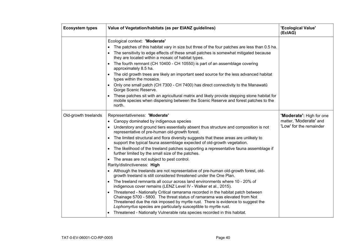
TAT-0-EV-06001-CO-RP-0005 Page 40
Ecosystem types Value of Vegetation/habitats (as per EIANZ guidelines) 'Ecological Value' (EcIAG)
Ecological context: 'Moderate' • The patches of this habitat vary in size but three of the four patches are less than 0.5 ha. • The sensitivity to edge effects of these small patches is somewhat mitigated because
they are located within a mosaic of habitat types. • The fourth remnant (CH 10400 - CH 10550) is part of an assemblage covering
approximately 8.5 ha. • The old growth trees are likely an important seed source for the less advanced habitat
types within the mosaics. • Only one small patch (CH 7300 - CH 7400) has direct connectivity to the Manawatū
Gorge Scenic Reserve. • These patches sit with an agricultural matrix and likely provide stepping stone habitat for
mobile species when dispersing between the Scenic Reserve and forest patches to the north.
Old-growth treelands Representativeness: 'Moderate' • Canopy dominated by indigenous species • Understory and ground tiers essentially absent thus structure and composition is not
representative of pre-human old-growth forest. • The limited structural and flora diversity suggests that these areas are unlikely to
support the typical fauna assemblage expected of old-growth vegetation. • The likelihood of the treeland patches supporting a representative fauna assemblage if
further limited by the small size of the patches. • The areas are not subject to pest control. Rarity/distinctiveness: High • Although the treelands are not representative of pre-human old-growth forest, old-
growth treeland is still considered threatened under the One Plan. • The treeland remnants all occur across land environments where 10 - 20% of
indigenous cover remains (LENZ Level IV - Walker et al., 2015). • Threatened - Nationally Critical ramarama recorded in the habitat patch between
Chainage 5700 - 5800. The threat status of ramarama was elevated from Not Threatened due the risk imposed by myrtle rust. There is evidence to suggest the Lophomyrtus species are particularly susceptible to myrtle rust.
• Threatened - Nationally Vulnerable rata species recorded in this habitat.
'Moderate': High for one matter, 'Moderate' and 'Low' for the remainder

TAT-0-EV-06001-CO-RP-0005 Page 41
Ecosystem types Value of Vegetation/habitats (as per EIANZ guidelines) 'Ecological Value' (EcIAG)
• The treeland areas are likely to be used, at least occasionally by mobile At Risk species such as whitehead but the limited flora diversity indicates that these areas are unlikely to support a diverse invertebrate assemblage and thus, are unlikely to be core habitat insectivorous species such as whitehead.
• Remnant populations of arboreal lizards such as Barking gecko, Ngahere gecko, Raukawa gecko and Pacific gecko could occur in this habitat. This is more likely in the patch between CH 4050 - CH 4150 because of its connectivity to the more intact old-growth forest.
• The heavily grazed ground tier suggests it is unlikely to support populations of Threatened or At Risk ground dwelling lizards or invertebrates.
Diversity and Pattern: Low • The absence of all structural tiers except the canopy limits the diversity of these areas. • The generally small size of the patches suggests the areas are subject to limited
underlying abiotic diversity. Ecological context: 'Moderate' • The individual patches (all smaller than 0.2 ha) are small and have limited structural and
flora diversity to represent key source habitats in the landscape. • However, the old-growth trees provide habitat characteristics such as cavities which are
rare, and often a limiting resource for native species such as cavity-nesting birds and bats.
• These the mature trees will also provide a seed source to more intact habitat types in the surrounding landscape as well as a fruit source for birds.
Kānuka Forests Representativeness: Low • Dominated by indigenous species. • Limited diversity of native broadleaved species in the canopy and in lower tiers. • The understory and ground tiers are modified by ungulate grazing, the extent of stock
damage varies between areas. • kānuka forest occurring across the Project is an artefact of stock degradation
suppressing broadleaved species from establishing. Kānuka forest would not have occurred in the area naturally.
'Moderate': high for one matter, 'Moderate' and 'Low'for the remainder

TAT-0-EV-06001-CO-RP-0005 Page 42
Ecosystem types Value of Vegetation/habitats (as per EIANZ guidelines) 'Ecological Value' (EcIAG)
• The limited structural and flora diversity suggests that these areas are unlikely to support the typical fauna assemblage expected of forest at this successional stage in the absence of ungulate browsing pressure.
• Only the area between CH 5100 - CH 5200 is subject to pest control. Rarity/distinctiveness: High • Kānuka is Threatened - Nationally Vulnerable. • Given the direct connectivity to the Manawatū Gorge Scenic Reserve it is likely that the
At Risk whitehead use the habitat at least occasionally. However, it is unlikely to be preferred habitat when compared to the old-growth forest types in close proximity.
• It is likely that At Risk lizards occur in this habitat given its direct connectivity to the Manawatū Gorge Scenic Reserve. This is particularly the case for arboreal lizards such as: Barking gecko, Ngahere gecko, Raukawa gecko, and Pacific gecko.
• Mature kānuka forest has been demonstrated to support a similar invertebrate assemblage to old-growth forest (but this is not case for less mature grazed stands). This forest type has the potential to support At Risk invertebrates such as Meterana species.
• Kānuka forest is considered threatened in the Horizons One Plan, but as above, kānuka forest would not have occurred in the area naturally.
• The Kānuka Forest patches all occur across land environments where 10 - 20% of indigenous cover remains (LENZ Level IV - Walker et al., 2015).
Diversity and Pattern: Low • The diversity in this habitat type is limited. • As discussed above, the vegetation assemblage does not reflect underlying abiotic
patterns, instead it is likely a result of heavy ungulate browse suppressing broadleaved species.
Ecological context: 'Moderate' • All kānuka forest patches are either contiguous with, or in close vicinity, to the
Manawatū Gorge Scenic Reserve or the Western QEII covenant. • The patch between CH 3900 - CH 4300, is large (approximately 3 ha) and forms part of
the much large forest assemblage of the Scenic Reserve. • The patch between CH 3900 - CH 4300 buffers to the raupō wetland immediately to the
west.

TAT-0-EV-06001-CO-RP-0005 Page 43
Ecosystem types Value of Vegetation/habitats (as per EIANZ guidelines) 'Ecological Value' (EcIAG)
• The other patches are smaller and limited in width but provide buffering to stream corridors. The sensitivity to edge effects is somewhat mitigated by the fact that these patches sit within a mosaic of habitat types.
• If protected from browsers these areas could be effectively restored. Succession towards broadleaf forest was observed in the patch between CH 5400 - CH 5600 which is fenced.
Advanced Secondary Broadleaved Forest
Representativeness: High • Dominated by indigenous species • Diversity generally representative of the successional stage of the habitat type but
lacking the diversity of the old-growth forest. • The flora diversity indicative that the area will support a typical fauna assemblage for the
successional stage of the vegetation. • The area is fenced and subject to pest control which indicates a higher likelihood of
more sensitive fauna occurring in these areas. Rarity/distinctiveness: High • Although generally comprised of mid-successional species, the vegetation is not
characteristic of old-growth forest types classified as threatened in the Horizons One Plan.
• These remnants occur across land environments where either, <10%, or 10 - 20% of indigenous cover remains (LENZ Level IV - Walker et al., 2015).
• Although not recorded during site investigations, Threatened kānuka and rata species may be present.
• Given the direct connectivity to the Manawatū Gorge Scenic Reserve it is likely that the At Risk whitehead use the habitat.
• It is highly likely that At Risk lizards (both arboreal and ground-dwelling) occur in this habitat given its connectivity to the Manawatū Gorge Scenic Reserve, stock exclusion and predator control.
• Potential to support Threatened or At Risk invertebrate species, both aerial and ground dwelling.
Diversity and Pattern: 'Moderate' • Diversity generally representative of the successional stage of the habitat type but
lacking the diversity of the old-growth forest.
Very High: high for 3 or all of the four assessment matters

TAT-0-EV-06001-CO-RP-0005 Page 44
Ecosystem types Value of Vegetation/habitats (as per EIANZ guidelines) 'Ecological Value' (EcIAG)
Ecological context: High • Both advanced broadleaved areas are part of a larger vegetation mosaic that is
contiguous with the Manawatū Scenic Reserve. • These patches all occur along the edges of these mosaics, providing buffer functionality
but are subject to increase edge effects. • The area sit within the Western QEII covenant which is legally protected and is less
impacted by stock access.
Secondary Broadleaved Forests and Scrublands
Generally as assessed for 'Advanced Secondary Broadleaved Forest' except that Ecological Context Diversity and Representative are assessed as 'Moderate' because: • Areas of this habitat type are scattered across the Project footprint and have various
patch sizes and levels of connectivity to old-growth habitats. • Represent an earlier successional stage and thus have a less diverse flora assemblage
and structure. • Many of these patches sit with an agricultural matrix and have been more modified by
stock degradation and likely subject to higher pest pressure.
'Moderate': High for 1 of the assessment matters, 'Moderate' or 'Low' for the remainder
Mānuka, Kānuka Shrublands
Representativeness: 'Low' • Generally dominated by indigenous species (kānuka) but exotic broom is a notable
canopy component in some areas. • All mānuka, kānuka shrubland patches are highly modified by stock access.
Consequently the understorey and groundcover tiers do not have a representative species assemblage and are often absent except for pasture grass.
• The low flora diversity and lack of habitat complexity suggests that the remnants are unlikely to support the full species assemblage that would be expected in a less modified early successional habitat type.
Rarity/distinctiveness: 'Moderate' • Mānuka and kānuka are both Threatened - Naturally Vulnerable however this status has
been applied as a precautionary measure due to the currently unquantified risk myrtle rust poses to species in the Myrtaceae family. This conservation status does not reflect actual declines in either mānuka or kānuka.
• Manuka, kānuka shrublands occur across land environments where either, <10%, or 10 - 20% of indigenous cover remains (LENZ Level IV - Walker et al., 2015).
'Moderate' (High for one assessment matter and low for the other three)

TAT-0-EV-06001-CO-RP-0005 Page 45
Ecosystem types Value of Vegetation/habitats (as per EIANZ guidelines) 'Ecological Value' (EcIAG)
• Scrub and shrubland, not identified has being in the Manawatu-Wanganui Region historically. Mānuka, kānuka shrublands are a common early successional habitat types and not considered rare or threatened in the Region.
• It is unlikely that Threatened or At Risk birds, lizards or terrestrial invertebrates occupy the patches given their small size, fragmentation, low flora diversity, and lack of understorey habitat for ground dwelling species.
• Notwithstanding the above, remnant populations of immobile species such as geckos are can sometimes occur such habitat. I consider this likelihood very low because of the evidence of herbicide application in these areas to prevent the encroachment of regenerating scrub across productive land.
• The habitat patches may be used as stepping stone habitat for mobile species but are unlikely to provide important breeding or foraging habitat for threatened or At Risk birds.
Diversity and Pattern: 'Low' • Low native diversity, limited to early successional species. • Grazing regimes preventing advancement to a more diverse, later-successional
assemblage. Ecological context: 'Low' • A number of small vegetation patches, primarily occurring within grazed pasture, subject
to stock modification and edge effects. • The spread of the shrubland across the landscape suggest that that the patches
contribute to landscape linkages for mobile species.
Divaricating Shrublands
Representativeness: 'Low' • Canopy generally dominated by indigenous species but canopy cover is low and the
areas are interspersed with exotic pasture. • The divaricating shrubland patches appear to be induced through human modification,
namely grazing pressure and aerial herbicide application to suppress mānuka/kānuka regeneration.
• The low flora diversity and lack of habitat complexity suggests that the remnants are unlikely to support the full assemblage of fauna that would be expected in a less modified early successional habitat type.
Rarity/distinctiveness: 'High' • The occasional mānuka and kānuka (both Threatened - Naturally Vulnerable) were
recorded in these areas. However, this status has been applied as a precautionary measure due to the unquantified risk Myrtle rust currently poses to species in the
'Moderate' (high for one assessment matter and 'Low' for the remaining 3)

TAT-0-EV-06001-CO-RP-0005 Page 46
Ecosystem types Value of Vegetation/habitats (as per EIANZ guidelines) 'Ecological Value' (EcIAG)
Myrtaceae family. This conservation status does not reflect actual declines in either mānuka or kānuka.
• No other Threatened, At Risk, or locally uncommon plant species have been identified in the shrublands.
• All of the divaricating shrubland patches occur within land environments where only 10 - 20% of indigenous cover remains (LENZ Level IV - Walker et al., 2015).
• Scrub and shrubland, has not been identified as being in the Manawatū-Wanganui Region historically (Maseyk, 2007). Thus, divaricating shrubland is not considered rare or threatened in this Region.
• Divaricating shrubs are known to support a diversity of invertebrates often with specific host plant associations.
• Literature reviews undertaken during the NoR process identified two At Risk moths (Meterana exquisita and M. grandiosa) could inhabit the Project footprint and the divaricating shrublands could support these species.
• The lack of understorey refugia suggests limited habitat for ground-dwelling invertebrates and lizards but remnant populations of At Risk arboreal geckos, including barking gecko and Ngahere gecko, could be present.
• As described above, the application of herbicide suggests the persistence of any remnant populations of immobile species is unlikely.
• The limited structural integrity of the shrublands suggests that they are unlikely to provide important breeding or foraging habitat for Threatened or At Risk birds with the exception of NZ pipit (At Risk - Declining).
Diversity and Pattern: 'Low' • Low native diversity, limited to early successional species. • Grazing regimes and herbicide application are preventing advancement to a more
diverse, later-successional assemblage. Ecological context: 'Low' • A number of small vegetation patches, primarily occurring within grazed pasture, subject
to stock modification and edge effects. • Unlike the mānuka, kānuka shrubland described above, the distribution of the
divaricating shrubland patches is largely limited to a single sub-catchment and, therefore, the contribution to connective linkages on a landscape scale is limited.

TAT-0-EV-06001-CO-RP-0005 Page 47
Ecosystem types Value of Vegetation/habitats (as per EIANZ guidelines) 'Ecological Value' (EcIAG)
Indigenous Dominated Seepage Wetland (raupō wetland)
Representativeness: 'Moderate' • Canopy dominated by indigenous species. • The remnant swamp maire is representative of the swamp forest that would have likely
occurred in the area prior to human modification but the remainder of the wetland is less representative of a pre-human assemblage.
• The limited structural diversity compared to the pre-human swamp forest suggests that the area is unlikely to support the typical fauna assemblage expected of intact wetland habitat.
• The area is not subject to pest control. Rarity/distinctiveness: 'High' • Swamp maire is classified as Threatened - Nationally Critical (the threat status of
Swamp maire was elevated from Not Threatened due the risk imposed by myrtle rust). • The raupō seepage occurs within a land environment where only 10 - 20% of indigenous
cover remains (LENZ Level IV - Walker et al., 2015). • Native-dominated seepage wetlands are classified as rare under the One Plan. • Intact wetlands generally are considered threatened with less than 5% remaining from
pre-human extent (Maseyk, 2007). • Several threatened wetland bird species potentially present though no wetland birds
have been recorded during the acoustic monitoring and wetlands lack open water which lowers the value of this habitat for some wetland bird species
• New Zealand pipit which inhabit open habitats including rough grassland and may nest under amongst rushes or rank grass.
Diversity and Pattern: 'Moderate' • Low native diversity compared to the swamp forest that would have occurred on the
alluvial soils originally. However, 'Moderate' diversity of native flora and fauna known or likely to be present
Ecological context: 'High' • Forms part of a mosaic of habitats with connectivity to old-growth forest and the
Manawatū Gorge Scenic Reserve. • Given the threat status of wetlands generally due to specific hydrological requirements,
the protection and restoration of wetlands is a priority under the RMA (Section 6) and the Draft National Policy Statement for Indigenous Biodiversity (Policy 12).
• The intact hydrology and its proximity to alluvial forest suggests that the area could be effectively restored if retired from grazing.
'High' ('High' for two matters and 'Moderate' or 'Low' for other matters)

TAT-0-EV-06001-CO-RP-0005 Page 48
Ecosystem types Value of Vegetation/habitats (as per EIANZ guidelines) 'Ecological Value' (EcIAG)
Indigenous Dominated Seepage Wetland - (Carex dominated wetlands)
Representativeness: 'Moderate' • Canopy dominated by indigenous species and known or likely to include flora and fauna
typical of Carex dominated wetlands. • The size of these seepage wetlands suggests that prior to forest clearance and stock
degradation these seepage areas would likely have been characterised by lowland forest surrounding watercourses.
• The limited structural diversity compared to the pre-human swamp forest suggests that the area is unlikely to support the typical fauna assemblage expected of intact wetland habitat.
• The area are not subject to pest control Rarity/distinctiveness: 'High' • The 'Moderate' value seepage wetlands occur within a land environment where only 10 -
20% of indigenous cover remains (LENZ Level IV - Walker et al., 2015). • Native-dominated seepage wetlands are classified as rare under the One Plan. • Intact wetlands generally are considered threatened with less than 5% remaining from
pre-human extent (Maseyk, 2007). • Several threatened wetland bird species potentially present though no wetland birds
have been recorded during the acoustic monitoring and wetlands lack open water which lowers the value of this habitat for some wetland bird species
• New Zealand pipit which inhabit open habitats including rough grassland and may nest within or adjacent to the wetland.
Diversity and Pattern: 'Low' • Native component largely limited to Carex geminata, likely induced by prolonged stock
access. Low native diversity compared to forest habitat that would have occurred in these areas originally.
Ecological context: 'High' • Given the threat status of wetlands generally due to specific hydrological requirements,
the protection and restoration of wetlands is a priority under the RMA (Section 6) and the Draft National Policy Statement for Indigenous Biodiversity (Policy 12).
• The intact hydrology of these wetland areas suggests that the area could be effectively restored if retired from grazing.
'High' ('High' for 2 matters and 'Low' or 'Moderate' for the remainder)

TAT-0-EV-06001-CO-RP-0005 Page 49
Ecosystem types Value of Vegetation/habitats (as per EIANZ guidelines) 'Ecological Value' (EcIAG)
Exotic Wetland (including pasture wetlands dominated by Juncus edgariae)
Representativeness: 'Low' • Dominated by exotic pasture species, or occasionally the common native rush Juncus
edgariae which often invades rough pasture. • The size of these seepage wetlands suggests that prior to forest clearance and stock
degradation these seepage areas would likely have been characterised by lowland forest surrounding small tributaries.
• The extent of modification to these areas resulting in a very limited structural diversity and a degraded hydrological system suggests that these areas are highly unlikely to support the typical fauna assemblage expected of intact wetland habitat.
• The areas are not subject to pest control. Rarity/distinctiveness: 'High' • Wetlands, irrespective of condition are a threatened habitat type and the protection and
restoration of wetlands is a priority under the RMA (Section 6) and the Draft National Policy Statement for Indigenous Biodiversity (Policy 12).
• The pasture wetlands occur within a land environment where only 10 - 20% of indigenous cover remains (LENZ Level IV - Walker et al., 2015).
• Native-dominated seepage wetlands are classified as rare under the One Plan but exotic dominated wetlands are not considered threatened under the One Plan.
• Although pasture wetlands score highly as an ecosystem type, the extensive modification of these areas suggests are very low likelihood of supporting Threatened or At Risk fauna.
Diversity and Pattern: 'Low' • Native component largely limited to a low cover of common rushes but generally
characterised by pasture species. • Heavily degraded by stock resulting in minimal habitat complexity.
Ecological context: 'Moderate' These wetlands are likely to constitute important stepping stones and provide habitat for mobile species such as pied stilt or pukeko and aquatic invertebrates that are dependent on wetlands with ephemeral or intermittent hyperiods to complete their life cycle.
'Moderate' (High for one matter, 'Moderate' and 'Low' for the remainder),

TAT-0-EV-06001-CO-RP-0005
Table 3: 'Ecological Value' assessment (as per EcIA guidelines) for each notable fauna species confirmed or potentially present in the Project designation.
Terrestrial fauna Conservation status (based on the most recent report issued
for each fauna group)
Observed within, or
close to the Project
footprint
'Ecological Value' of species (as per EIANZ guidelines)
Plant species
Giant maidenhair* At Risk - Relict Yes 'Moderate'
Kānuka** Threatened -
Nationally Vulnerable Yes 'Very high'
Mānuka** At Risk - Declining Yes 'High'
Ramarama** Threatened -
Nationally Critical Yes 'Very high'
Rohutu** Threatened -
Nationally Critical Yes 'Very high'
Rātā** Threatened -
Nationally Vulnerable Yes 'Very high'
White rātā** Threatened -
Nationally Vulnerable Yes 'Very high'
Climbing rātā** Threatened -
Nationally Vulnerable Yes 'Very high'
Akatea** Threatened -
Nationally Vulnerable Yes 'Very high'
Swamp maire Threatened -
Nationally Critical Yes 'Very high'

TAT-0-EV-06001-CO-RP-0005 Page 51
Terrestrial fauna Conservation status (based on the most recent report issued
for each fauna group)
Observed within, or
close to the Project
footprint
'Ecological Value' of species (as per EIANZ guidelines)
Native bats
Long tailed bat Threatened - Nationally Critical
No (closest record 13 km from footprint)
'Very High'
Native forest birds of 'Moderate' or higher value that are present or potentially present within the Project footprint
Pōpokatea (Whitehead) At Risk - Declining Yes 'High'
Rifleman At Risk - Declining Yes 'High'
New Zealand pipit At Risk - Declining Yes 'High'
New Zealand robin At Risk - Declining No (but within 55 km of footprint)
'High'
Kārearea (New Zealand Falcon)
At Risk - Recovering Yes 'Moderate'
Kaka At Risk - Recovering No 'Moderate'
Kākāriki (Cyanoramphus novaezelandiae)
At Risk - Relict No (but possible sighting within 55 km of footprint)
'Moderate'
Long-tailed cuckoo At Risk - Naturally Uncommon
No 'Moderate'
Kereru Not Threatened Yes 'Moderate'
Tui Not Threatened Yes 'Moderate'
Bellbird Not Threatened Yes 'Moderate'
Native wetland birds of 'Moderate' or higher value that are present or potentially present within the Project footprint
Matuku hūrepo (Australasian bittern)
Threatened - Nationally Critical
No 'Very High'

TAT-0-EV-06001-CO-RP-0005 Page 52
Terrestrial fauna Conservation status (based on the most recent report issued
for each fauna group)
Observed within, or
close to the Project
footprint
'Ecological Value' of species (as per EIANZ guidelines)
Pūweto (spotless crake) At Risk - Declining No 'High'
Koitareke (marsh crake) At Risk - Declining No 'High'
Native river birds of 'Moderate' or higher value that are present or potentially present within the Project footprint
Banded dotterel Threatened - Nationally Vulnerable
Yes 'Very high'
Black-fronted dotterel At Risk - Naturally Uncommon
Yes 'Moderate'
Red-billed gull At Risk - Declining No 'High'
Black-billed gull Threatened - Nationally Critical
Yes (Parahaki Island ca 600 m from BRO2 footprint)
'Very High'
Taranui (Caspian tern) Threatened - Nationally Vulnerable
Yes 'Very High'
Tūturiwhatu (banded dotterel)
Threatened - Nationally Vulnerable
Yes (ca 600 m from BR02 footprint)
'Very High'
Pied shag At Risk - Recovering No 'Moderate'
Little black shag At Risk - Naturally Uncommon
No 'Moderate'
Kawau (black shag) At Risk - Naturally Uncommon
Yes 'Moderate'
Open water (pond) dwelling birds that are present or potentially present within the Project footprint
Australian coot At Risk - Naturally Uncommon
No 'Moderate'
New Zealand dabchick At Risk - Recovering No 'Moderate'

TAT-0-EV-06001-CO-RP-0005 Page 53
Terrestrial fauna Conservation status (based on the most recent report issued
for each fauna group)
Observed within, or
close to the Project
footprint
'Ecological Value' of species (as per EIANZ guidelines)
Native lizards of 'Moderate' or higher value that are present or potentially present within the Project footprint
Barking gecko (Naultinus punctatus)
At Risk - Declining Yes 'High'
Ngahere gecko (Mokopirirakau "southern North Island")
At Risk - Declining Yes 'High'
Raukawa gecko (Woodworthia maculatus)
Not Threatened Yes 'Low'
Glossy brown skink (Oligosoma zelandicum)
At Risk - Declining No 'High'
Ornate skink (Oligosoma ornatum)
At Risk - Declining No 'High'
Pacific gecko (Dactylocnemis pacificus)
At Risk - Relict No 'Moderate'
Native invertebrates of 'Moderate' or higher value that are present or potentially present within the Project footprint
Megadromus turgidceps (beetle)
Not classified - possibly locally uncommon
No 'Moderate'
Meterana grandiosa (moth)
At Risk - Relict No 'Moderate'
Meterana exquisita (moth)
At Risk - Relict No 'Moderate'
Powelliphanta traversi traversi (snail)
Threatened - Nationally Endangered
No 'Very high'
Powelliphanta traversi tararuaensis (snail)
Threatened - Nationally Endangered
No 'Very high'
Powelliphanta marchanti (snail)
Threatened - Serious Decline
No 'Very high'
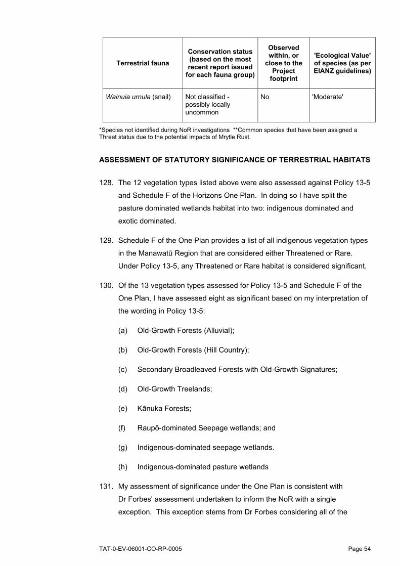
TAT-0-EV-06001-CO-RP-0005 Page 54
Terrestrial fauna Conservation status (based on the most recent report issued
for each fauna group)
Observed within, or
close to the Project
footprint
'Ecological Value' of species (as per EIANZ guidelines)
Wainuia urnula (snail) Not classified - possibly locally uncommon
No 'Moderate'
*Species not identified during NoR investigations **Common species that have been assigned a Threat status due to the potential impacts of Mrytle Rust.
ASSESSMENT OF STATUTORY SIGNIFICANCE OF TERRESTRIAL HABITATS
128. The 12 vegetation types listed above were also assessed against Policy 13-5
and Schedule F of the Horizons One Plan. In doing so I have split the
pasture dominated wetlands habitat into two: indigenous dominated and
exotic dominated.
129. Schedule F of the One Plan provides a list of all indigenous vegetation types
in the Manawatū Region that are considered either Threatened or Rare.
Under Policy 13-5, any Threatened or Rare habitat is considered significant.
130. Of the 13 vegetation types assessed for Policy 13-5 and Schedule F of the
One Plan, I have assessed eight as significant based on my interpretation of
the wording in Policy 13-5:
(a) Old-Growth Forests (Alluvial);
(b) Old-Growth Forests (Hill Country);
(c) Secondary Broadleaved Forests with Old-Growth Signatures;
(d) Old-Growth Treelands;
(e) Kānuka Forests;
(f) Raupō-dominated Seepage wetlands; and
(g) Indigenous-dominated seepage wetlands.
(h) Indigenous-dominated pasture wetlands
131. My assessment of significance under the One Plan is consistent with
Dr Forbes' assessment undertaken to inform the NoR with a single
exception. This exception stems from Dr Forbes considering all of the

TAT-0-EV-06001-CO-RP-0005 Page 55
pasture wetlands to be exotic dominated, based on the information available
at that time. Further site investigations showed that some of the modified
pasture wetlands are in fact dominated by a native rush Juncus edgariae.
These wetlands are degraded by stock access and were assessed as having
a 'Moderate' 'Ecological Value' using the EcIAG methodology. However, the
criteria in Schedule F only takes into account native or exotic vegetation
dominance as opposed to habitat intactness measures. Consequently these
wetlands are considered Rare in Schedule F, and therefore significant under
the One Plan.
132. A summary of this assessment is provided in Table 4 below.
Table 4: Assessment of ecological significance of vegetation types in the Project designation through the application of criteria in Schedule F and Policy 13-5 of the Horizons One Plan.
Ecosystem type
Equivalent vegetation type
listed in Table F.1 in Schedule F and
threat classification
Assessment as per
Horizons One Plan Policy
13-5
Notes
Old-Growth Forests (Alluvial)
Kahikatea - pukatea - tawa forest or treeland Threatened
Significant Policy 13-5 (a)(i)(A)
Old-Growth Forests (Hill Country)
Podocarp/tawa - mahoe forest or treeland Threatened
Significant Policy 13-5 (a)(i)(A)
Secondary Broadleaved Forests with Old-Growth Signatures
Podocarp/tawa - mahoe forest or treeland Threatened
Significant Policy 13-5 (a)(i)(A)
Secondary Broadleaved Forest and scrublands
Does not represent pre-human forest compositions defined in Schedule F Not threatened
Not significant Policy 13-5 (a)
Old-Growth Treelands
Podocarp/tawa - mahoe forest or treeland Threatened
Significant Policy 13-5 (a)(i)(A)
I have assessed the individual treeland areas against the criteria in Tables F.2(a) and F.2(b) in Schedule F for determining the significance.

TAT-0-EV-06001-CO-RP-0005 Page 56
Ecosystem type
Equivalent vegetation type
listed in Table F.1 in Schedule F and
threat classification
Assessment as per
Horizons One Plan Policy
13-5
Notes
Advanced Secondary Broadleaved Forests
Does not represent pre-human forest compositions defined in Schedule F Not threatened
Not significant Policy 13-5 (a)
Kānuka Forests Kanuka forest or Treeland Threatened
Significant Policy 13-5 (a)(i)(A)
Mānuka and Kānuka Shrublands
Does not represent any of the shrubland definitions compositions outlined in Schedule F Not threatened
Not significant Policy 13-5 (a)
Divaricating Shrublands
Does not represent any of the shrubland definitions outlined in Schedule F Not threatened
Not significant Policy 13-5 (a)
Indigenous Dominated Seepage Wetland – High Value (raupō wetland)
Seepage and spring wetland Rare
Significant Policy 13-5 (a)(ii)(E)
I have assessed the individual treeland areas against the criteria in Tables F.2(a) and F.2(b) in Schedule F for determining the significance.
Indigenous-Dominated Seepage Wetlands
Seepage and spring wetland Rare
Significant Policy 13-5 (a)(ii)(E)
Indigenous dominated Pasture wetlands dominated by Juncus edgariae
Seepage and spring wetland Rare
Significant Policy 13-5 (a)(ii)(E)
The criteria in Schedule F does not distinguish between more intact wetlands dominated by native vegetation and highly degraded pasture wetlands dominated by native rushes.

TAT-0-EV-06001-CO-RP-0005 Page 57
Ecosystem type
Equivalent vegetation type
listed in Table F.1 in Schedule F and
threat classification
Assessment as per
Horizons One Plan Policy
13-5
Notes
Exotic-dominated Pasture wetlands
Not dominated by indigenous vegetation thus does not represent any of the wetland definitions outlined in Schedule F Not threatened
Not significant Policy 13-5 (a)

TAT-0-EV-06001-CO-RP-0005 Page 58
MAGNITUDE OF EFFECTS' ASSESSMENT
133. The 'Magnitude of Effects' section is set out as follows:
(a) General overview of potential effects;
(b) Effects avoidance measures (Project shaping and refinement);
(c) Effects minimisation measures (development and implementation of
management plans); and
(d) EcIAG 'Magnitude of Effects' Assessment after avoidance and
minimisation measures (Step 2).
General overview of potential effects
134. The terrestrial and wetland habitat loss has the potential to create a range of
adverse effects on ecological values, both during enabling works construction
(resulting from direct physical disturbance), seasonal construction, and
potentially on an ongoing basis from operations that involve vegetation
removal or habitat disturbance.
135. Potential adverse effects on terrestrial and wetland values during and after
construction may include:
(a) Vegetation and habitat loss through vegetation clearance and
earthworks;
(b) The creation of habitat edge effects, altering the composition and
health of adjacent vegetation (i.e. habitat degradation), which may
affect habitat suitability for flora and fauna;
(c) Direct mortality or injury to species, for example all plants and most of
the smaller less mobile species (e.g. lizards or invertebrates) that may
be harmed during vegetation clearance or earthworks activities.
Outside of bird breeding season, bird mortality would be low though
disturbance can still be an issue. During breeding season, vegetation
removal has the potential to result in the destruction of nests, eggs and
fledglings;
(d) Habitat fragmentation and isolation due to the loss and reduction of
available habitat types and by reducing the ability for plants and
animals to disperse across the landscape for food, shelter, and

TAT-0-EV-06001-CO-RP-0005 Page 59
breeding purposes, i.e. severing or partially severing access to habitats
that would otherwise be suitable;
(e) Construction and operations related noise and vibrations or dust
effects; and
(f) Sediment runoff to wetlands and watercourses that may affect the
quality of wetland habitat.
136. Potential long-term ongoing adverse effects on vegetation, lizard and
avifauna values may include:
(a) Ongoing habitat degradation associated with habitat loss, edge effects
and fragmentation, permanently affecting movement of some species,
with possible effects on meta-population dynamics and increased
vulnerability to local extinction;
(b) Ongoing disturbance effects, particularly on habitat margins/edges,
through noise and lighting associated with operational activities;
(c) Mortality or injury on roads through strike or road kill for some species;
(d) Degradation of wetland and riparian habitat quality through:
(i) Altered hydrology of wetlands;
(ii) Contaminated stormwater runoff (sediment, heavy metals and
elevated temperature) from road surface to wetlands; and
(iii) Risk of spills of potential toxins (for example, oil or chemicals)
from cartage vehicles.
Avoidance of adverse ecological effects
137. Considerable effort has been undertaken through various phases and stages
of the Project to avoid adverse effects as detailed in the AEE and DCR and
as summarised below.
Assessment of alignment options
138. A multi-criteria analysis ("MCA") was undertaken during earlier stages of the
Project. Although I was not involved in the Project at the time, my
understanding is that a number of potential route options were excluded from
further consideration due in whole or in part to high levels of ecological risk or

TAT-0-EV-06001-CO-RP-0005 Page 60
effects. This MCA process facilitated early avoidance of key ecological
values.
Refinement of the Project designation corridor and Project alignment
139. The Project designation was shaped during the NOR process which included
constraining the designation to avoid potential impacts on key areas such as
Parahaki Island, the Western QEII and Eastern QEII covenant areas,
Bolton's Bush and regenerating forest adjacent to the Manawatū Gorge
Scenic Reserve.
140. As discussed above, the 'Northern Alignment' now proposed by the Transport
Agency reduces the effects of the Project on terrestrial ecology values, as
compared to the NoRs as confirmed by the Transport Agency in June 2019,
by significantly reducing the affected areas within the Western QEII and
Eastern QEII covenants.
141. The Designation Conditions (which provide for the Northern Alignment)
prescribe a range of specific measures that the Transport Agency will take
(including for example the imposition of effects 'envelopes' for various habitat
types, which was a focus of the NoR process and Dr Forbes' reporting during
that process) to seek to avoid and minimise the potential effects of the
Project on terrestrial ecological values.
142. Since the NoRs were confirmed in June 2019, the Project design process
has focused on avoidance and minimisation of ecological effects through the
following key measures (which capture but go well beyond the introduction of
the Northern Alignment):
(a) Lengthening BR03 and location of bridge piers to avoid old-growth
swamp maire and to minimise impacts on the high value raupō wetland
CH 4000 - CH 4200;
(b) Locating the wetland walking track along the BR03 staging to avoid the
need for additional vegetation clearance;
(c) Shifting the alignment further north between CH 5400 - CH 6000 so the
road traverses the northern edge of the Western QEII covenant rather
than the middle reaches of the gully. This shift reduces the area of
forest directly impacted and also avoids severance of the western QEII
gully.

TAT-0-EV-06001-CO-RP-0005 Page 61
(d) The batters on the alignment traversing the Western QEII covenant
have also been steepened to further reduce encroachment into this
high value habitat.
(e) Shifting the alignment further north between CH 6000 - CH 6600 to
avoid severance of the eastern QEII gully and significantly reducing the
extent of impact on this ecosystem.
(f) Reduction in the physical extent of impact on the old growth treeland
containing ramarama (CH 5700 - CH 5800) through the reshaping of
stormwater wetland 5.
143. The design changes outlined above to reduce impacts on the aforementioned
QEII covenants have required increased scale of earthworks and hence a
larger amount of spoil for disposal. 32 spoil site locations were considered
and shortlisted to 8 based on a number of considerations including ecological
effects (details of this assessment are provided in the DCR).
NoR effects envelopes
144. Finally, it is important to emphasise that the effects envelopes agreed during
the NoR process have been adhered to so as to avoid additional impact on
high value habitats not envisioned during the NoR process.
145. During the NoR process effects envelopes (i.e. maximum area of removal
permitted for each habitat type) were developed as a way of ensuring effects
in the high value areas would be appropriately minimised. These effects
envelopes were outlined in Table 1 of Condition 18 in the Transport Agency
decision version of the designation conditions (June 2019). They have since
been updated as part of the Environment Court appeals, to reflect the
reduced 'Level of Effects' associated with the Northern Alignment. The
updated NoR effects envelopes are set out in Condition 24 in the Designation
Conditions, and replicated in Table 5 in this report).
146. As detailed above, the construction design has resulted in reductions to the
impact area for most habitat types as compared to the NoR effects
envelopes. When all relevant ecosystem types are added together, total
habitat loss across the Project footprint is 16.79 ha. That figure includes the
area outside the designation boundaries.
147. This compares to a total allowable loss of 31 ha, provided for by the original
NoR effects envelopes, reduced to 27.85 ha through mediation. This is a

TAT-0-EV-06001-CO-RP-0005 Page 62
significant reduction of effects compared to what was anticipated through the
NoR process. Importantly, there have been reductions in the impacted areas
of a number of the High Value / significant habitat types.
148. The only instance in which the area proposed for removal is above the
effects envelope is for 'exotic wetlands' now defined as 'pasture wetlands'.
However, this was specifically provided for in the conditions on the
understanding that further wetlands would likely be identified or impacted.
Further survey work has identified additional pasture wetlands within the
Project footprint, which have been included in the updated total.
149. In addition, the exotic wetlands habitat type occurs in a number of the
proposed spoil sites, many of which extend beyond the designation
boundaries (the NoR effects envelopes are limited to within the designation).
150. Table 5 summarises the areal extent of habitat within the designation
boundaries, and the now-proposed extent of vegetation clearance (across
the full Project footprint) compared to the effects envelopes as set out in the
Designation Conditions.

Page 63
Table 5: Extent of vegetation clearance relative to respective effects envelopes set out in the NOR
Name
Area within proposed
Designation boundaries
Maximum area of vegetation able to
be removed in accordance with
Designation Condition 24 (ha)
Total area impacted by Project footprint
Secondary broadleaved forests with old growth signatures 3.07 2.39 0.25
Old growth Treeland (including Ramarama Area) 0.41 0.26 0.13
Kānuka forests (CH4000 - 4400) 4.52
1 0.91
Kanuka forests (elsewhere) 0.59 0.39
Advanced secondary broadleaved forest (CH5600 -5800) 2.93
0.09 0.04
Advanced secondary broadleaved forest (elsewhere) 0.41 0
Secondary broadleaved forests and scrublands (CH6100 - 6400)
16.32 0.03 0.025
Secondary broadleaved forests and scrublands (elsewhere) 14.12 6.68
Mānuka and kānuka shrublands (CH6100 -6400)
4.12
0 0
Mānuka and kānuka shrublands (elsewhere) 3.63 2.11
Divaricating shrublands 0.33 0.33
Old growth forest alluvial 4.23 0.15 0.10
Old growth forest hill country 1.78 0.86 0.85

Page 64
Name
Area within proposed
Designation boundaries
Maximum area of vegetation able to
be removed in accordance with
Designation Condition 24 (ha)
Total area impacted by Project footprint
Indigenous Dominated Seepage Wetlands High Value 0.55 0.13 0.11
Indigenous Dominated Seep Wetlands 'Moderate' Value 0.66 1.12 0.44
Exotic Wetlands Low Value* (Pasture wetlands) 2.74 4.42*
Totals 27.85 16.79 * condition 18(e) of the NoR allows envelope for wetland areas to be increased and so exceeding quoted level is not a breach.

Page 65
Measures to minimise adverse effects that cannot be avoided
151. The Designation Conditions stipulate the requirement for an Ecology
Management Plan ("EMP"). The draft EMP has been prepared and
appended to this document. The EMP covers all of the condition
requirements outlined in the Designation Conditions as well as additional
minimisation measures including, but not limited to, translocation of nest
epiphytes from removed vegetation and the translocation of Adiantum
formosa.
152. Refer to the Ecology Management Plan (refer to Volume VII) for a detailed
outline of the avoidance and minimisation measures provided through the
Designation Conditions. The plan includes sub-plans that have been
developed, including for vegetation clearance, bats, avifauna, lizards and
invertebrates. The key mitigation measures are also summarised below.
153. Key aspects of the Vegetation Clearance Management Plan include:
(a) Clearly delimiting the extent of vegetation clearance and ensuring
vegetation is felled into the Project footprint to minimise impacts on the
remaining vegetation;
(b) Retention of high-value felled vegetation for use as habitat
enhancement (e.g. woody debris) in restoration areas where
practicable;
(c) Weed control and infill planting along newly created edges;
(d) Removal and storage of top soil from impacted vegetation areas to be
relocated to offset planting areas;
(e) Fencing, predator control, weed control in restoration and
enhancement areas;
(f) Cultural and eco-sourcing requirements and propagation of seed
collected from site for the planting in the offset areas; and
(g) Specific replacement ratios for the removal of selected Threatened
plant species: swamp maire, ramarama, rōhutu, and Adiantum
formosum.

Page 66
154. The Bat Management Plan focuses primarily on annual monitoring and
implementing Tree Removal Protocols, where bat activity is identified to
ensure any occupied roosts are not removed.
155. Key aspects of the Avifauna Management Plan include:
(a) A restriction on vegetation clearance during peak breeding season from
September through to December inclusive unless a pre-clearance
survey for indigenous birds protected by the Wildlife Act is undertaken
to minimise impacts on nesting birds (note if nesting birds are found
then an exclusion zone will be established until nesting activities are
completed);
(b) Pre-construction surveys for braided river birds (black-billed gulls,
black-fronted dotterel and banded dotterel) on the unvegetated area of
Parahaki Island in the vicinity of the BR02 footprint;
(c) Establishment of deterrents to prevent native braided river birds from
nesting in the Project footprint during construction;
(d) Exclusion zones established around dotterel nests if nests established;
(e) Ongoing surveys during construction to ensure new dotterel nests are
quickly identified and exclusion zones established;
(f) Pre-clearance nest surveys for native indigenous birds protected by the
Wildlife Act in woody vegetation;
(g) Surveys for the presence of cryptic wetland birds in the high value
raupō prior to works in the area;
(h) Grazing and/or mowing regimes to prevent NZ pipit nesting in rank
grass prior to commencement of construction activities; and
(i) Exclusion zones around farm ponds to prevent unnecessary
disturbance to waterfowl.
156. Key aspects of the Lizard Management Plan include:
(a) Salvage of lizards prior to vegetation removal;
(b) Vegetation removal protocols to minimise harm to lizards that were not
located during pre-clearance surveys including:
(i) Supervision of vegetation clearance by an ecologist; and

Page 67
(ii) Stockpiling vegetation adjacent to retained habitat to allow
remaining lizards to disperse prior to mulching.
(c) Location of the proposed lizard relocation site and habitat
enhancement actions (this may be updated to be consistent with permit
requirements).
157. Key aspects of the Invertebrate Management Plan (refer to Dr Curry's
commentary in Appendix F.2 for more detail) include:
(a) The requirement, prior to the commencement of construction works,
preconstruction surveys to determine invertebrate community
composition and the presence of 'At Risk' or 'Threatened' taxa;
(b) Once the surveys are completed, the Management Plan will be
updated as appropriate.
'Magnitude of Effects' assessment after effects avoidance and minimisation
158. The proposed designation covers 340 ha, of which 41.85 ha (12.31 %)
comprises the 12 habitat types described in detail above. Of the 41.85 ha of
habitat identified in the designation corridor, 15.11 ha (36% of that available
in the designation) will be directly removed under the Project footprint (which
includes the alignment, spoil sites, the shared use path, temporary clearance
required for construction and enabling works). A further 0.56 ha of Manuka
and kanuka shrubland and 1.12 ha of pasture wetlands will be lost in areas
associated with spoil sites outside the designation corridor (but within the
Project footprint).
159. This equates to a total loss of 11.82 ha of indigenous terrestrial habitats and
4.97 ha of wetland habitats as a result of the Project or 16.79 ha overall.
160. The tables below provide a summary of effects associated with the Project
footprint, and using the EcIAG methodology, assign a 'Magnitude of Effect'
for each habitat type and species (or groups of species where the 'Magnitude
of Effects' is similar). The tables also include a summary of measures to
avoid, remedy and mitigate these effects and provide a final 'Magnitude of
Effect', taking into account the mitigation proposed. As explained above,
these tables take into account only those measures proposed to avoid or
minimise and mitigate adverse effects. This does not include habitat
restoration or enhancement that is associated with proposed offsetting or
compensation measures.

Page 68

Page 69
Table 6: 'Magnitude of Effect' for each habitat type in the Project footprint assessed using EcIAG methodology
Vegetation/ habitat type
Direct impact (extent of vegetation removal)
Indirect impacts (the quality of remaining habitat may be
degraded due to changes in edge microclimate as a result of increased exposure to light and wind, increased
incursions of pest plants, and from dust deposition)1
Minimisation measures Magnitude of effect
Old-growth forest (alluvial)
0.10 ha, which equates to 2.4% of what is available within the designation corridor and noting that this habitat type is down to 2.5% of its original extent in the Region. This habitat lies within the construction footprint and will be replaced in the long-term
Potential edge effects resulting from the proposed design have been assessed as ''Negligible'' for the following reasons:
- A very small area proposed for removal along an existing edge, minimising changes in exposure to the biotic and abiotic factors listed above;
- The proposed alignment is located downwind of the prevailing winds hence dust deposition during construction will be limited.
- Further fragmentation avoided as an existing edge is being removed.
- Physical delineation to ensure no over clearance of vegetation.
- Clearance extent minimised through pruning as opposed to felling of old-growth trees where possible.
- Clearance extent along habitat edges, avoiding fragmentation.
- Seasonal restrictions and/or pre-clearance protocols will be put in place to minimise harm to native fauna including native snails, lizards, and birds (Refer to the EMP in Volume VII).
- Epiphyte and coarse woody debris relocation will reduce harm to invertebrates and provide habitat enhancement in adjacent forest (Refer to the EMP in Volume VII).
- Dust suppression is proposed across the Project footprint during construction and monitoring will be undertaken at old-growth forest adjacent to Project footprint (refer to Technical Assessment E).
'Moderate'
Old-growth forest (hill country)
Permanent loss of 0.85 ha. This equates to 48% of what is available in the designation corridor and < 1% of what is available on the local landscape (i.e.,
Potential edge effects resulting from the proposed design have been assessed as 'Low' for the following reasons:
- Shifting the impact area to the head of the Western QEII gully avoids fragmentation and results in the shifting of an existing edge rather than the creation of two new edges in addition to the existing edge.
- The vegetation adjacent to the new edge is currently less than 100 m in width and
'Moderate'

Page 70
Vegetation/ habitat type
Direct impact (extent of vegetation removal)
Indirect impacts (the quality of remaining habitat may be
degraded due to changes in edge microclimate as a result of increased exposure to light and wind, increased
incursions of pest plants, and from dust deposition)1
Minimisation measures Magnitude of effect
the adjacent Manawatū Scenic Reserve but noting that it is threatened ecosystem type in the region with 19% of its former extent remaining.
therefore is likely already exposed to edge effects, albeit at a lesser extent.
- The existing alignment is located upwind of the prevailing wind and therefore dust deposition is more likely to occur during construction.
- Weed control and enrichment planting to be undertaken in newly created edges (Refer to the EMP in Volume VII).
- Replacement planting at a scale of 1:100 for any swamp maire pruned, or 1:200 for swamp maire felled.
- Replacement planting at a scale of 1:100 for any ramarama felled.
Secondary broadleaved forests with old-growth signatures
Long-term loss of 0.04 ha, which equates to 1.3% of availability within the designation corridor and noting that this habitat type is uncommon in the wider landscape
Potential edge effects resulting from the proposed design have been assessed as ''Negligible'' - 'Low' for the following reasons:
- The impact areas are either already fragmented and exposed to edge effects (CH 7300 - CH 7400) or a very small area proposed for removal along an existing edge. Hence both areas are already exposed to edge effects, albeit at a lesser extent.
- The existing alignment is located upwind of the prevailing wind at both impact areas and therefore dust deposition is likely to occur during construction. It is noted that the area located at CH 7300 - CH 7400 is already exposed to some dust deposition effects from an unsealed farm track that exists along this edge.
- Physical delineation to ensure no over clearance of vegetation.
- Clearance extent along habitat edges, avoiding fragmentation.
- Areas of the forest remnant between CH 10400 - CH 10600 that actually contain old-growth trees are avoided.
- Seasonal restrictions and/or pre-clearance protocols will be implemented to minimise harm to native fauna including native snails, lizards, and birds (Refer to draft EMP in Volume VII).
- Dust suppression proposed across the footprint during construction (refer to Technical Assessment E)
'Low'

Page 71
Vegetation/ habitat type
Direct impact (extent of vegetation removal)
Indirect impacts (the quality of remaining habitat may be
degraded due to changes in edge microclimate as a result of increased exposure to light and wind, increased
incursions of pest plants, and from dust deposition)1
Minimisation measures Magnitude of effect
- Weed control and enrichment planting to be undertaken in newly created edges (Refer to the EMP in Volume VII).
Old-growth treelands
Permanent loss of 0.13 ha, which equates to 32% of availability within the designation corridor and noting that this habitat type is common in the wider landscape
Potential edge effects resulting from the proposed design have been assessed as ''Negligible'' for the following reasons:
- The treeland remnants are very small and open (< 30 m at the widest point) and hence will already be exposed to high levels of edge effects; and
- The understory is already dominated by exotic plants.
- Physical delineation to ensure no over clearance of vegetation.
- Clearance extent minimised through pruning as opposed to felling of old-growth trees where possible.
- The stormwater wetland proposed for the area has been modified to almost completely avoid the ramarama area.
- Seasonal restrictions and/or pre-clearance protocols will be put in place to minimise harm to native fauna including: lizards and birds (Refer to the EMP in Volume VII).
- Dust suppression is proposed across the Project footprint during construction (refer to Technical Assessment E)
'Low'
Kānuka forests
1.3 ha, which equates to 29% of availability within the designation
Potential edge effects resulting from the proposed design have been assessed as 'Negligible' - 'Low' for both impact areas for the following reasons:
- Physical delineation to ensure no over clearance of vegetation.
- Seasonal restrictions and/or pre-clearance protocols will be put in
'Moderate'

Page 72
Vegetation/ habitat type
Direct impact (extent of vegetation removal)
Indirect impacts (the quality of remaining habitat may be
degraded due to changes in edge microclimate as a result of increased exposure to light and wind, increased
incursions of pest plants, and from dust deposition)1
Minimisation measures Magnitude of effect
corridor. Although kānuka forest is considered threatened regionally, the kānuka forest available in the designation corridor appears to be created as a product of sustained grazing pressure, and is likely to be common in the surrounding rural landscape.
- The areas impacted are along existing edges. However in the case of CH 3900 - CH 4300, vegetation clearance will shift this edge considerably (>50 m), exposing an area of canopy that has previously been relatively protected from the abiotic effects. Notwithstanding this the area is grazed underneath and the understory is dominated by exotic plants. Hence the impacts of light-demanding pest plants colonising the new edge will be minimal; and
- The proposed alignment is located upwind of the prevailing wind but the construction of the viaduct will not create a large area of exposed earth, limiting dust deposition potential.
- At CH 5400 - CH 5600, a small area is proposed for removal and the proposed alignment is located downwind of the prevailing winds hence dust deposition during construction will be limited.
place to minimise harm to native fauna including: lizards, birds and bats (Refer to the EMP in Volume VII).
- Dust suppression is proposed across the Project footprint during construction (refer to Technical Assessment E)
- Weed control and enrichment planting to be undertaken in newly created edges (Refer to the EMP in Volume VII).
Advanced secondary broadleaved forest
Long-term loss of 0.04 ha, which equates to 1.4 % of availability within the designation corridor.
Potential edge effects resulting from the proposed design have been assessed as 'Low' for the following reasons:
- A small area is proposed for removal and this habitat type is located along an existing gully edge, limiting changes in exposure to the biotic and abiotic factors listed above; and
- Physical delineation to ensure no over clearance of vegetation.
- Seasonal restrictions and/or pre-clearance protocols will be put in place to minimise harm to native fauna including: lizards, birds and bats (Refer to the EMP in Volume VII).
'Low'

Page 73
Vegetation/ habitat type
Direct impact (extent of vegetation removal)
Indirect impacts (the quality of remaining habitat may be
degraded due to changes in edge microclimate as a result of increased exposure to light and wind, increased
incursions of pest plants, and from dust deposition)1
Minimisation measures Magnitude of effect
Regenerating broadleaved forest at various stages of succession are common in the surrounding landscape and are not listed as threatened in the region.
- The proposed alignment is located upwind of the prevailing wind and therefore dust deposition is likely to occur during construction.
- Dust suppression is proposed across the Project footprint during construction (refer to Technical Assessment E)
- Weed control and enrichment planting to be undertaken in newly created edges, including temporary edges (Refer to the EMP in Volume VII)
Secondary broadleaved forests and scrublands
6.44 ha which equates to 39% of availability within the designation corridor. As above, regenerating broadleaved forest at various stages of succession are common in the surrounding landscape and are not listed as threatened in the region.
Potential edge effects resulting from the proposed design have been assessed as Negligible' - 'Low' all of the impact locations with the exception of two (details below). The reasoning is below: - the secondary broadleaved forests and
scrublands are comprised relatively early successional species that are robust to increased exposure abiotic factors listed above;
- Many of these areas are already small, fragmented by the existing land use, and interspersed with pest plants, namely broom.
- In most cases further fragmentation avoided as existing edges is being removed.
- These patches occur at different positions relative to the proposed alignment and thus will be impacted by dust deposition
- Seasonal restrictions and/or pre-clearance protocols will be put in place to minimise harm to native fauna including: lizards and birds (Refer to the EMP in Volume VII).
- Dust suppression is proposed across the Project footprint during construction (refer to Technical Assessment E)
- Weed control and enrichment planting to be undertaken in newly created edges (Refer to the EMP in Volume VII).
- Translocation of Adiantum formosum located at CH 3800 - CH 4000 and additional planting of 1:15 for each relocated plant.
'Moderate'
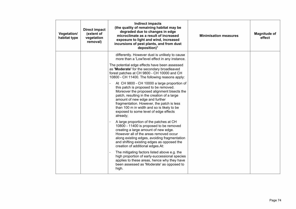
Page 74
Vegetation/ habitat type
Direct impact (extent of vegetation removal)
Indirect impacts (the quality of remaining habitat may be
degraded due to changes in edge microclimate as a result of increased exposure to light and wind, increased
incursions of pest plants, and from dust deposition)1
Minimisation measures Magnitude of effect
differently. However dust is unlikely to cause more than a 'Low'level effect in any instance.
The potential edge effects have been assessed as 'Moderate' for the secondary broadleaved forest patches at CH 9800 - CH 10000 and CH 10800 - CH 11400. The following reasons apply:
- At CH 9800 - CH 10000 a large proportion of this patch is proposed to be removed. Moreover the proposed alignment bisects the patch, resulting in the creation of a large amount of new edge and further fragmentation. However, the patch is less than 100 m in width and so is likely to be exposed to some level of edge effects already;
- A large proportion of the patches at CH 10800 - 11400 is proposed to be removed creating a large amount of new edge. However all of the areas removed occur along existing edges, avoiding fragmentation and shifting existing edges as opposed the creation of additional edges.At:
- The mitigating factors listed above e.g. the high proportion of early-successional species applies to these areas, hence why they have been assessed as 'Moderate' as opposed to high.

Page 75
Vegetation/ habitat type
Direct impact (extent of vegetation removal)
Indirect impacts (the quality of remaining habitat may be
degraded due to changes in edge microclimate as a result of increased exposure to light and wind, increased
incursions of pest plants, and from dust deposition)1
Minimisation measures Magnitude of effect
Mānuka, kānuka shrublands
2.11 ha, which equates to > 50 % of the availability within the designation corridor. This shrubland type is common in the surrounding landscape and appears to readily establish in pasture. It is not threatened in the region.
Potential edge effects resulting from the proposed design have been assessed as ''Negligible'' for the following reasons:
- All mānuka, kānuka shrubland patches are small, isolated and regularly impacted by stock. Consequently, the areas are already exposed to edge effects and are currently comprised of early successional species that are robust to increased exposure abiotic factors listed above.
- Physical delineation to ensure no over clearance of vegetation.
- Seasonal restrictions and/or pre-clearance protocols will be put in place to minimise harm to native fauna including: lizards and birds (Refer to the EMP in Volume VII).
- Dust suppression is proposed across the Project footprint during construction (refer to Technical Assessment E)
- Weed control and enrichment planting to be undertaken in newly created edges (Refer to the EMP in Volume VII).
'Moderate'
Divaricating shrublands
0.33 ha, which equates to > 50 % of the availability within the designation corridor. The divaricating shrublands within the designation corridor appear to be closely
Potential edge effects resulting from the proposed design have been assessed as ''Negligible'' for the following reasons:
- All divaricating shrubland patches are small, isolated and regularly impacted by stock. Consequently, the areas are already exposed to edge effects and are currently comprised of early successional species that are robust to increased exposure abiotic factors listed above.
- Physical delineation to ensure no over clearance of vegetation.
- Seasonal restrictions and/or pre-clearance protocols will be put in place to minimise harm to native fauna including: lizards, birds and terrestrial invertebrates (Refer to the EMP in Volume VII).
- Dust suppression is proposed across the Project footprint during construction (refer to Technical Assessment E)
Low

Page 76
Vegetation/ habitat type
Direct impact (extent of vegetation removal)
Indirect impacts (the quality of remaining habitat may be
degraded due to changes in edge microclimate as a result of increased exposure to light and wind, increased
incursions of pest plants, and from dust deposition)1
Minimisation measures Magnitude of effect
associated with the manuka, kanuka shrubland. It appears to be common in the landscape. It is not threatened in the region.
- If Meterana spp. Recorded in the area - a grazing or mowing regime will be continued across the remaining divaricating shrubland patches within the designation to promote the areas remaining in a stalled successional trajectory dominated by divaricating shrubs (Refer to the EMP in Volume VII).
Raupō-dominated seepage wetlands (high value)
0.11, which equates to 20 % of the availability within the designation corridor. Raupō wetlands appear to be rare in the wider landscape and in the region noting that only 3% of wetlands remain in the region.
High
- The raupō wetland occurs within a matrix of forest, scrub and grassland and is generally quite open. The dominant wetland component, raupō, is adapted to open environments and are robust to increased exposure abiotic factors associated with the creation of new edge.
- Wetlands are naturally fragmented across the landscape due to the specific landforms they occur within. Hence the species that inhabit wetlands are generally mobile and fragmentation resulting from the Project is unlikely to impact the movement of fauna or dispersal of seed more than the existing agricultural matrix.
- Notwithstanding the above, fragmentation of the high value raupō wetland has been
- Physical delineation to ensure no over clearance of vegetation.
- The staging piles will be capped to ensure artesian aquifer is not ruptured, thus maintaining the current hydrology.
- Seasonal restrictions and/or pre-clearance protocols will be put in place to minimise harm to native wetland birds potentially nesting in the area (Refer to the EMP in Volume VII).
'Moderate'

Page 77
Vegetation/ habitat type
Direct impact (extent of vegetation removal)
Indirect impacts (the quality of remaining habitat may be
degraded due to changes in edge microclimate as a result of increased exposure to light and wind, increased
incursions of pest plants, and from dust deposition)1
Minimisation measures Magnitude of effect
avoided by the extension of BR03 to limit impacts in the area.
An indirect impact specific to wetland habitat types is changes in hydrology impacting species assemblages.
- The hydrology of the raupō appears to be somewhat impacted by stock access but is generally intact. Geotechnical investigations have found that the raupō wetland is located above an artesian aquifer. Construction of the Project has the potential to rupture this aquifer which would change the hydrology of the raupō wetland considerably.
Indigenous-dominated seepage wetlands ('Moderate' value)
0.44 (which equates to 66.7 % of this type of wetland available in the designation corridor) Indigenous dominated seepage wetlands appear to be rare in the surrounding
''Negligible'' - All of the 'Moderate' and 'Low' value
wetlands on the site occur in open areas and the species inhabiting the different wetland types are adapted to open environments and are robust to increased exposure abiotic factors associated with the creation of new edge.
- Wetlands are naturally fragmented across the landscape due to the specific landforms they occur within. Hence the species that inhabit wetlands are generally mobile and fragmentation resulting from the Project is unlikely to impact the movement of fauna or
- Physical delineation to ensure no over clearance of vegetation.
- Seasonal restrictions and/or pre-clearance protocols will be put in place to minimise harm to native lizards, and birds potentially nesting in the area (Refer to the EMP in Volume VII).
'High'

Page 78
Vegetation/ habitat type
Direct impact (extent of vegetation removal)
Indirect impacts (the quality of remaining habitat may be
degraded due to changes in edge microclimate as a result of increased exposure to light and wind, increased
incursions of pest plants, and from dust deposition)1
Minimisation measures Magnitude of effect
landscape and in the region.
dispersal of seed more than the existing agricultural matrix.
An indirect impact specific to wetland habitat types is changes in hydrology as well as sedimentation and pollution impacting species assemblages. - The hydrology of the 'Moderate' and
'Low'value wetlands appear to be impacted by stock pugging and the native species dominating these wetlands (Juncus edgariae and Carex geminata) are not limited to strict hydrological conditions. Consequently it is unlikely that any hydrological changes caused by the Project will have a discernible impact on these wetland assemblages.
Pasture wetlands, dominated by exotic species or the common native rush Juncus edgariae (low value) Numerous locations across the Footprint
4.23 ha, which constitutes an unknown but likely high proportion of wetlands in the designation corridor. Wetlands in improved pasture are common in the surrounding landscape, but noting that freshwater wetlands are down to 3% of their formal extent in the region.
- Physical delineation to ensure no over clearance of vegetation.
- Seasonal restrictions and/or pre-clearance protocols will be put in place to minimise harm to pipit eggs and unfledged chicks (Refer to the EMP in Volume VII).
'Moderate'

Page 79
Table 7: 'Magnitude of Effect' for flora, long-tailed bat, bird, lizard and invertebrate species potentially occurring in the Project footprint assessed using EcIAG methodology.
Species Extent of habitat removal Potential impacts1 Avoidance and minimisation measures
'Magnitude of Effect'
Giant maidenhair Plants could be lost due to vegetation clearance activities within secondary broadleaf forest adjacent to the Manawatū River.
Direct impacts • Loss of individuals during vegetation
clearance; and • Loss of potential habitat; Indirect impacts • Edge effects degrading remaining
habitat; and • Fragmentation due to potential road
barrier.
- Dust suppression is proposed across the Project during construction (refer to Technical Assessment E)
- Weed control and enrichment planting to be undertaken in newly created edges (Refer to theEMP in Volume VII).
- Translocation of Adiantum formosum located at CH 3800 - CH 4000 and additional planting of 1:15 for each relocated plant
'Moderate'
Kānuka*/ mānuka* Up to 3.41 ha of kānuka forest
and mānuka, kānuka shrublands (as addressed at ecosystem level in Table 6); and other scattered individuals within other forests, shrublands and wetlands
Direct impacts • Loss of individuals during vegetation
clearance; and • Loss of potential habitat; Indirect impacts • Edge effects degrading remaining
habitat; and • Fragmentation due to potential road
barrier.
- Dust suppression is proposed across the Project during construction (refer to Technical Assessment E)
- Weed control and enrichment planting to be undertaken in newly created edges (Refer to the EMP in Volume VII).
'Moderate'

Page 80
Species Extent of habitat removal Potential impacts1 Avoidance and minimisation measures
'Magnitude of Effect'
Ramarama* rohutu (Lophomyrtus spp.) and swamp maire
Small numbers of plants could potentially be removed during vegetation clearance activities within treeland or old growth forest habitats
Direct impacts • Loss of individuals during vegetation
clearance; and • Loss of potential habitat; Indirect impacts • Edge effects degrading remaining
habitat; and • Fragmentation due to potential road
barrier.
- Clearance extent minimised through pruning as opposed to felling of old-growth trees where possible.
- Clearance extent along habitat edges, avoiding fragmentation.
- Dust suppression is proposed across the Project during construction and monitoring will be undertaken at old-growth forest adjacent to Project footprint (refer to Technical Assessment E).
- Weed control and enrichment planting to be undertaken in newly created edges (Refer to the EMP in Volume VII).
- Replacement planting at a scale of 1:100 for any swamp maire pruned, or 1:200 for swamp maire felled.
- Replacement planting at a scale of 1:100 for any ramarama and rohutu felled.
- Ramarama area identified in NoR reporting avoided (which contained ramarama and rohutu individuals)
'Low'

Page 81
Species Extent of habitat removal Potential impacts1 Avoidance and minimisation measures
'Magnitude of Effect'
Rātā vines* (Metrosideros spp.)
All rata vines that are present in Old growth forest types in the footprint will be lost noting that this will constitute < 1% of available loss withi - n the surrounding landscape (which includes the Manawatu Gorge Scenic Reserve).
Direct impacts • Loss of individuals during vegetation
clearance; and • Loss of potential habitat; Indirect impacts • Edge effects degrading remaining
habitat; and • Fragmentation due to potential road
barrier;
- Dust suppression is proposed across the Project during construction (refer to Technical Assessment E)
- Weed control and enrichment planting to be undertaken in newly created edges (Refer to the EMP in Volume VII).
'Moderate'
Long-tailed bat (refer to Appendix F.1)
Based on survey findings it is assumed that bats do not regularly use habitats within the Project footprint but the possibility that they move through the landscape on occasion cannot be ruled out. Correspondingly impacts associated with habitat loss are expected to be negligible
Impacts associated with habitat loss or other indirect effects are not expected. Despite this, monitoring will be undertaken and management measures initiated if bats begin to use the area over the course of construction. The reasoning for this precautionary approach is the high threat status of long-tailed bats,
Pre-clearance protocols will be put in place to minimise potential harm to long-tailed bats potentially roosting in the area (refer to the EMP in Volume VII). Fragmentation effects minimised in key areas through: • BR03 will facilitate the
potential dispersal of long-tailed bats along the Manawatū River corridor.
• The shift of the alignment to the northern extent of the western QEII gullies avoids fragmentation of the gully.
'Negligible'
Birds associated with forest and shrublands
11.82 ha of forest and shrublands, which equates to 32% of available habitat within the designation corridor and approximately 2% of the habitat
Direct impacts • Decreased breeding success
(mortality of eggs during vegetation
Seasonal restrictions and/or pre-clearance protocols will be put in place to minimise harm to birds potentially nesting in
'Moderate' for resident birds

Page 82
Species Extent of habitat removal Potential impacts1 Avoidance and minimisation measures
'Magnitude of Effect'
Confirmed resident in surrounding landscape: Kereru, bellbird, tui, whitehead, rifleman, tomtit Potential occasional visitors: Kaka, kakariki, North Island Robin, long-tailed cuckoo
available in the surrounding landscape (due to the presence of the Manawatu Gorge Scenic Reserve). The impact extent above includes: • Old-growth forest (alluvial); • Old-growth forest (hill
country); • Secondary broadleaved
forests with old-growth signatures;
• Old-growth treelands; • Kānuka forests; • Advanced secondary
broadleaved forest; • Secondary broadleaved
forests and scrublands; • Mānuka, kānuka shrublands; • Divaricating shrublands; and • Mature exotic forest and
treelands It is assumed that these species could potentially use all forest and shrubland types in the Project footprint. However the more intact, old-growth areas are likely to be preferred habitat.
clearance if undertaken during the nesting season);
• Loss of breeding and foraging habitat; and
• Mortality from vehicle strike (low-level impact).
Indirect impacts • Edge effects degrading remaining
habitat. • Fragmentation due to potential road
barrier. • Fragmentation due to removal of
some stepping stone habitat.
the area (refer to the EMP in Volume VII). Weed control and enrichment planting to be undertaken in newly created edges to minimise edge effects (refer to the EMP in Volume VII). Planting adjacent to carriageway designed to discourage native birds from using the area, thus minimising potential for vehicle strike. Fragmentation effects minimised in key areas through: • BR03 will facilitate
dispersal of birds between the Manawatū Gorge Scenic Reserve and the Old-growth forest to the east.
• The shift of the alignment to the northern extent of the western QEII gullies avoids fragmentation of the gully.
Low for occasional visitors (e.g. kaka and kakariki)
Kārearea (bush falcon)
Kārearea are wide ranging habitat generalists, they occur in agricultural areas where suitable forest remnants remain and forage over grassland.
Direct impacts • Decreased breeding success
(mortality of eggs during vegetation clearance if undertaken during the nesting season);
Seasonal restrictions and/or pre-clearance protocols will be put in place to minimise harm to birds potentially nesting in
'Moderate'

Page 83
Species Extent of habitat removal Potential impacts1 Avoidance and minimisation measures
'Magnitude of Effect'
Consequently it is conservatively assumed that falcon use all vegetated areas available in the designation corridor, including the improved pasture. Habitat loss is estimated at 42.94 ha. This includes all forest and shrubland habitat types (11.82 ha), exotic pine forest (1.12 ha) and approx 30 ha of pasture that will not be reinstated. Proportionally, this loss equates to <1% of forest or shrubland habitat within the surrounding landscape (due to the presence of the Manawatu Gorge Scenic Reserve) and a 'Negligible' proportion of available pine forest or pasture habitat in the surrounding landscape.
• Loss of breeding and foraging habitat; and
• Mortality from vehicle strike (low-level impact).
Indirect impacts • Edge effects degrading remaining
habitat. • Fragmentation due to potential road
barrier. • Fragmentation due to removal of
some stepping stone habitat.
the area (refer to the EMP in Volume VII). Weed control and enrichment planting to be undertaken in newly created edges to minimise edge effects (refer to the EMP in Volume VII). Planting adjacent to carriageway designed to discourage native birds from using the area, thus minimising potential for vehicle strike. Fragmentation effects minimised in key areas through: • BR03 will facilitate
dispersal of birds between the Manawatū Gorge Scenic Reserve and the Old-growth forest to the east.
• The shift of the alignment to the northern extent of the western QEII gullies avoids fragmentation of the gully.
New Zealand pipit 4.97 ha of wetlands (of all types) and ca 30 ha of pasture that will be permanently lost (i.e., pasture that lies under the road footprint as opposed to the construction footprint). This is approximately
Direct impacts • Decreased breeding success
(Mortality of eggs during vegetation clearance/earthworks, if undertaken during the nesting season);
A grazing and/or mowing regime will be adhered to across the currently grazed pasture areas located in the Project footprint. The purpose of this is to prevent currently
Low

Page 84
Species Extent of habitat removal Potential impacts1 Avoidance and minimisation measures
'Magnitude of Effect'
10% of the pasture habitat available habitat within designation corridor and a very low proportion of what is available in the surrounding landscape.
• Loss of breeding and foraging habitat; and
• Mortality from vehicle strike. Indirect impacts • Fragmentation due to potential road
barrier. Pipit nest in rough grassland where they can conceal their nests under vegetation. Given the majority of the grassland habitat within the Project footprint is grazed, it is unlikely that there is significant breeding habitat within the footprint. An exception is the pasture wetland areas. Pipit also forage over open pasture. The prevalence of pasture grassland in the surrounding landscape means that the removal of these areas, although large, is unlikely to reduce the pipit population in the area. Given the prevalence of open habitat across the Project footprint, pipit do not have the same requirements as forest dwelling birds such as whitehead to move between isolated habitat patches. Hence the impacts of habitat fragmentation are likely to be 'Negligible'.
unsuitable nesting habitat going rank and becoming preferential pipit nesting habitat prior to construction commencing. Pre-clearance protocols in place in potential pipit nesting areas will be put in place to minimise harm to birds potentially nesting in the area (refer to draft EMP in Volume VII). Priority habitat is the 'Moderate' and 'Low' value wetlands where the water table is low but there is increased rush and sedge cover for nesting.
All wetland birds potentially present within impacted freshwater wetlands (e.g.
0.55 ha of temporary loss, which equates to 45% of available potential habitat within the designation corridor.
Direct impacts • Decreased breeding success
(mortality of eggs during vegetation clearance if undertaken during the nesting season); and
Seasonal restrictions and/or pre-clearance protocols will be put in place to minimise harm to birds potentially nesting in
Low

Page 85
Species Extent of habitat removal Potential impacts1 Avoidance and minimisation measures
'Magnitude of Effect'
Australian bittern, spotless crake, marsh crake)
The impact extent above includes: • Raupō-dominated seepage
wetlands; • Indigenous-dominated
seepage wetlands; and It is assumed that these wetland birds could potentially use all wetland types in the Project footprint. It should be noted that this is a conservative assumption given none of these species have been observed in the designation corridor despite wetland bird surveys.
• Loss of breeding and foraging habitat. Indirect impacts • Edge effects degrading remaining
habitat. • Fragmentation due to potential road
barrier. • Fragmentation due to removal of
some stepping stone habitat. A small area (0.55 ha) of indigenous dominated seepage wetland is proposed for removal. The remaining wetland removal is characterised by highly modified pasture wetlands that are unlikely to provide important habitat for any of the above species. Given that none of the wetland species in question have been recorded in the designation corridor after targeted acoustic surveys indicates that the wetland removal will be unlikely to have population-level effects on the wetland bird populations in the wider landscape.
the area (Refer to the EMP in Volume VII). Weed control and enrichment planting to be undertaken in newly created edges (Refer to the EMP in Volume VII). Fragmentation effects have been minimised at the key raupo wetland through the extension of BR03. This will facilitate dispersal of birds through the habitat mosaic that characterises the Western Rise area.
Native ducks potentially present in farm ponds (New Zealand dabchick and Australian coot)
2 ha of open water farm ponds, which likely equates to a 'Moderate' proportion of available pond habitat within the designation corridor and a very small proportion of pond habitat within the wider landscape The impact extent above includes:
Direct impacts • Decreased breeding success
(mortality of eggs during vegetation clearance if undertaken during the nesting season); and
• Loss of breeding and foraging habitat. Indirect impacts
Exclusion zones set-up around the farm ponds that are in the Designation but outside of the Construction Footprint (refer to the EMP in Volume VII).
''Negligible''

Page 86
Species Extent of habitat removal Potential impacts1 Avoidance and minimisation measures
'Magnitude of Effect'
• Farm ponds A subset of the farm ponds across the designation corridor were opportunistically surveyed for notable native waterfowl. Neither of these species were identified, but I have assumed that they may occasionally use these habitats.
• Fragmentation due to potential road barrier.
• Fragmentation due to removal of some stepping stone habitat.
The small area of impact in combination with the fact that neither of these species have been confirmed in the designation indicates that this impact is unlikely to have population level effects. Edge effects are not considered here given that pond are small habitats located within a pasture matrix.
Threatened or At Risk birds potentially nesting on the exposed gravel riverbed Confirmed prospecting in the Project footprint: Black-fronted dotterel Confirmed resident in surrounding landscape: Black-billed gull, banded dotterel, and Caspian tern. Potentially present:
No potential nesting habitat will be lost
Direct impacts • Decreased breeding success
(Abandonment of nests due to disturbance during construction, if undertaken during the nesting season); and
Indirect impacts • Noise disturbance of nesting pairs
during construction. Noise disturbance considered 'Moderate'. It is unknown how black-fronted dotterels respond to construction-related disturbance while nesting. NZ dotterels however, are known to be resilient to such disturbance and regularly breed successfully in construction sites. Black-billed gulls likely to be robust to disturbance given the instance of a
Deterrence mechanisms to be employed to deter river birds from nesting in the vicinity of the BR02 footprint. If birds do nest in the vicinity of the BR02 footprint, a 50 m exclusion zone will be put in place until the chicks have fledged, or the nest fails.
''Negligible''

Page 87
Species Extent of habitat removal Potential impacts1 Avoidance and minimisation measures
'Magnitude of Effect'
Red-billed gull. successful nesting colony in downtown Christchurch. Furthermore, closest sightings of black-billed gulls have been approximately 600 m downstream.

Page 88
At Risk native lizards
11.82 ha of forest and shrublands, which equates to 32% of available habitat within the designation corridor and approximately 2% of the habitat available in the surrounding landscape (due to the presence of the Manawatu Gorge Scenic Reserve); and improved pasture. The impact extent above includes: • Old-growth forest (alluvial); • Old-growth forest (hill
country); • Secondary broadleaved
forests with old-growth signatures;
• Old-growth treelands; • Kānuka forests; • Advanced secondary
broadleaved forest; • Secondary broadleaved
forests and scrublands; • Mānuka, kānuka shrublands; • Divaricating shrublands; and • Improved pasture To date no lizards have been identified in the designation corridor, however there are inherent limitations to surveying for lizards over large areas. Hence it is conservatively assumed that At Risk lizards are present a low densities across all of the forest and shrubland
Direct impacts • Injury or mortality during vegetation
clearance and earthworks; and • Removal of habitat leading to
decreased population size. Indirect impacts
• Edge effects degrading remaining habitat; and
• Fragmentation of remaining habitat. Due to the limited mobility of lizards they have an increased risk of mortality during vegetation clearance and earthworks. The habitat proposed for removal is of varying quality for lizards with the highest quality habitat being 2.5 ha of old-growth forest and kānuka forest. Without mitigation / offset / compensation, the removal of these areas could pose a population-level effect for at least some of the lizard species assumed to be present. The key area where edge effects will occur is likely to be the new edge created within the old-growth hill country forest, kānuka forest and the secondary broadleaf forest and shrublands. All other areas impacted are already small in size and likely subject to edge effects already. Again, because of the limited mobility of lizards, fragmentation of habitats can lead to populations becoming isolated. However in this instance this is considered to be a 'Low' level effect because most of the habitats being impacted are already located within an agricultural matrix. Hence, if populations
Seasonal restrictions and/or pre-clearance salvage protocols will be put in place to minimise harm to lizards occupying habitat with the Project footprint (refer to the EMP in Volume VII). A grazing and/or mowing regime will be adhered to across the currently grazed pasture areas located in the Project footprint. The purpose of this is to prevent grazed pasture which is currently unsuitable for northern grass skink becoming rank and skinks moving into this habitat prior to construction commencing Weed control and enrichment planting to be undertaken in newly created edges (refer to the EMP in Volume VII). Dust control being undertaken across the Project.
'Moderate'

Page 89
Species Extent of habitat removal Potential impacts1 Avoidance and minimisation measures
'Magnitude of Effect'
are occurring in these habitats, they will already be isolated to a large extent.
All invertebrates potentially present in forest and scrubland habitats (See Appendix F.2)
11.82 ha of forest and shrublands, which equates to <1% of the habitat available in the surrounding landscape (due to the presence of the Manawatu Gorge Scenic Reserve
Direct impacts • Injury or mortality during vegetation
clearance and earthworks; and • Removal of habitat leading to
decreased population size. Indirect impacts • Edge effects degrading remaining
habitat; and • Fragmentation of remaining habitat. Due to the limited mobility of invertebrates they have an increased risk of mortality during vegetation clearance and earthworks. The habitat proposed for removal is of varying quality for invertebrates with the highest quality habitat being 2.5 ha of old-growth forest and kānuka forest. Without mitigation, the removal of these areas could pose a population-level effect for at least some of the invertebrate species assumed to be present. The key area where edge effects will occur is likely to be the new edge created within the old-growth hill country forest, kānuka forest and the secondary broadleaf forest and shrublands. All other areas impacted are already small in size and likely subject to edge effects already.
Seasonal restrictions and/or pre-clearance salvage protocols will be put in place to minimise harm to invertebrates occupying habitat with the Project footprint (refer to the EMP in Volume VII). Weed control and enrichment planting to be undertaken in newly created edges (refer to the EMP in Volume VII). Dust control being undertaken across the Project.
'Moderate'

Page 90
Species Extent of habitat removal Potential impacts1 Avoidance and minimisation measures
'Magnitude of Effect'
Again, because of the limited mobility of invertebrates, fragmentation of habitats can lead to populations becoming isolated. However in this instance this is considered to be a 'Low' level effect because most of the habitats being impacted are already located within an agricultural matrix. Hence, if populations are occurring in these habitats, they will already be isolated to a large extent.
*Common species that were formerly classified as 'Not Threatened' but that have been assigned national threat categories due to risks associated with Myrtle rust
but that are common in the landscape and for which Myrtle rust does not appear to result in significant adverse impacts will not be specifically addressed through
effects management despite their assessed 'Level of Effects' category.

Page 91
'Level of Effects' after avoidance and minimisation
160. The 'Level of Effects' section is structured as follows
(a) 'Level of Effects' after avoidance and minimisation; and
(b) Key changes from the NoR assessment.
161. The table below uses the EcIAG matrix to assign an overall 'Level of Effect'
of the Project on terrestrial and wetland habitats and associated species.
This matrix is based on the assessed values of the habitat types and the
species of interest in combination with the assessed 'Magnitude of Effects'
after avoidance and minimisation measures (refer to APPENDIX F.5, Tables
F.5.1 - F.5.6).
162. Through avoidance and minimisation measures, a number of ecological
effects will largely be managed to '''Negligible'' or 'Low'' levels, though there
some effects on local biodiversity values that have been assessed as being
'Moderate'' or ''High'. Most notably, I expect the Project to have 'potentially
High' or 'High' level of residual effects on the following local biodiversity
values after avoidance and minimisation measures:
(a) 0.1 ha of old growth forest (alluvial);
(b) 0.85 ha of old growth forest (hill country);
(c) 6.71 ha of secondary broadleaf forest;
(d) 0.55 ha of indigenous dominant seepage wetland; and
(e) Up to 11.82 ha of potential habitat for the nationally 'At Risk' whitehead
and rifleman, up to four 'At Risk' lizard species and up to seven
nationally 'Threatened' or 'At Risk' invertebrates if present.
163. Importantly, no residual adverse effects are deemed to be 'Very High'.
164. Where the 'Level of Effects' is assessed at being 'potentially' 'Moderate' or
higher after practicable measures to minimise effects have been undertaken,
and in accordance with the EcIAG guidelines, I consider it appropriate to
offset or compensate for these residual effects through habitat restoration
and enhancement measures.
165. The 'Level of Effects' for terrestrial and wetland habitats and associated
species, after effects and avoidance measures, is set out in Table 8 below.

Page 92
Table 8. Level of residual effects for terrestrial and wetland habitats and associated species after effects avoidance and minimisation measures (as per EcIAG step 3)
Biodiversity value within the Project footprint (ha)
'Ecological Value'
'Magnitude of Effect' after avoidance and minimisation
'Level of Effect' after avoidance and minimisation
Vegetation/ habitat type
Old-growth forest (alluvial) 'Very High' 'Moderate' 'High'
Old-growth forest (hill country) 'Very High' 'Moderate' 'High'
Secondary broadleaved forests with old-growth signatures
'High' 'Moderate' 'High'
Old-growth treelands (+ ramarama) 'High' 'Low' 'Moderate'*
Kānuka Forests 'Moderate' 'Moderate' 'Moderate'
Advanced Secondary Broadleaved Forest
'High' 'Low' 'Moderate'*
Secondary Broadleaved Forests and Scrublands
'Moderate' 'Moderate' 'Moderate'
Mānuka, Kānuka Shrublands 'Moderate' 'Moderate' 'Moderate'
Divaricating Shrublands 'Moderate' 'Moderate' 'Moderate'
Indigenous Dominated Seepage Wetland - High Value (raupō wetland)
'Very High' 'Moderate' 'High'
Indigenous Dominated Seepage Wetland - 'Moderate' Value (Carex dominated wetlands)
'Moderate' 'High' 'Moderate'
Exotic Wetland (including pasture wetlands dominated by Juncus edgariae)
'Moderate' 'Moderate' 'Moderate'
Plant species
Giant maidenhair 'High' 'Moderate' 'Moderate'

Page 93
Biodiversity value within the Project footprint (ha)
'Ecological Value'
'Magnitude of Effect' after avoidance and minimisation
'Level of Effect' after avoidance and minimisation
Kānuka** 'Very High' 'Moderate' Low'***
Mānuka** 'Very High' 'Moderate' Low***
Ramarama** 'Very High' 'Low' Low'***
Rohutu 'Very High' 'Low' Low***
Rātā** 'Very High' 'Low' Low'***
White rātā** 'Very High' 'Low' Low***
Climbing rātā** 'Very High' 'Low' Low'***
Akatea** 'Very High' 'Low' Low***
Swamp maire 'Very High' 'Low' Low'***
Bats
Long-tailed bat 'Very High' 'Negligible' Low
Bird species
Australasian bittern 'Very High' Potentially 'Low'
'Moderate'
Banded dotterel 'Very High' 'Negligible' Low
Black-billed gull 'Very High' 'Negligible' Low
Caspian tern 'Very High' 'Negligible' Low
Red-billed gull 'High' 'Negligible' Very 'Low'

Page 94
Biodiversity value within the Project footprint (ha)
'Ecological Value'
'Magnitude of Effect' after avoidance and minimisation
'Level of Effect' after avoidance and minimisation
Whitehead 'High' 'Moderate' 'Moderate'
Spotless crake 'High' Potentially 'Low'
'Moderate'
NZ pipit 'High' Very 'Low' 'Low'
Marsh crake 'High' Potentially 'Low'
'Moderate'
Rifleman 'High' 'Moderate' 'Moderate'
North Island robin 'High' 'Moderate' 'Moderate'
Kakariki 'Moderate' 'Low' 'Low'
Kaka 'Moderate' Low 'Low
Australian coot 'Moderate' 'Negligible' 'Very Low'
NZ dabchick 'Moderate' 'Negligible' 'Very Low'
Bush falcon 'Moderate' 'Moderate' 'Moderate'
Long-tailed cuckoo 'Moderate' 'Moderate' 'Moderate'
Pied shag 'Moderate' 'Negligible' 'Very Low'
Black shag 'Moderate' 'Negligible' 'Very Low'
Little black shag 'Moderate' 'Negligible' 'Very Low'
Black-fronted dotterel 'Moderate' ''Negligible'' 'Low'
Kereru 'Moderate' 'Moderate' 'Moderate'

Page 95
Biodiversity value within the Project footprint (ha)
'Ecological Value'
'Magnitude of Effect' after avoidance and minimisation
'Level of Effect' after avoidance and minimisation
Bellbird 'Moderate' 'Moderate' 'Moderate'
Tui 'Moderate' 'Moderate' 'Moderate'
Lizard species
Barking gecko 'High' Potentially 'Moderate'
Potentially 'Moderate'
Ngahere gecko 'High' Potentially 'Moderate'
Potentially 'Moderate'
Raukawa gecko 'Low' Potentially 'Moderate'
'Low'
Pacific gecko 'Moderate' Potentially 'Moderate'
Potentially 'Moderate'
Glossy brown skink 'High' Potentially 'Moderate'
Potentially 'Moderate'
Ornate skink 'High' Potentially 'Moderate'
Potentially 'Moderate'
Invertebrate species
Powelliphanta traversi traversi (snail) 'Very high' Potentially 'Moderate'
Potentially 'High'
Powelliphanta traversi tararuaensis (snail)
'Very high' Potentially 'Moderate'
Potentially 'High'
Powelliphanta marchanti (snail) 'Very high' Potentially 'Moderate'
Potentially 'High'

Page 96
Biodiversity value within the Project footprint (ha)
'Ecological Value'
'Magnitude of Effect' after avoidance and minimisation
'Level of Effect' after avoidance and minimisation
Megadromus turgidceps (beetle) 'Moderate' Potentially 'Moderate'
Potentially 'Moderate'
Meterana xquisite (moth) 'Moderate' Potentially 'Moderate'
Potentially 'Moderate'
Meterana xquisite (moth) 'Moderate' Potentially 'Moderate'
Potentially 'Moderate'
Wainuia urnula (snail) 'Moderate' Potentially 'Moderate'
Potentially 'Moderate'
*High values with 'Low' 'Magnitude of Effects' were assessed as having 'Moderate' 'Level of Effects' despite the EcIAG guidelines table assessing High value and 'Low' 'Magnitude of Effects' as a 'Low' 'Level of Effect'
**Species that have been assigned national threat categories due to risks associated with Myrtle rust but that are common in the landscape and not known to be adversely affected Myrtle Rust will not be specifically addressed through effects management despite their 'Level of Effects' category.
*** In accordance with '**' above, the project is assessed as having a 'Low' 'Level of Effect' for these species. This is despite a higher 'Level of Effect' outcome that results from strict adherence to the EcIAG. The 'Low' 'Level of Effect' assigned was on the basis that that these are common species for which the potential impact of Myrtle rust, based on observations, is seemingly not as high as anticipated during the assignment of Threat Classifications by DOC.

Page 97
Key changes from the NOR assessment 166. Table 9 below sets out the overall assessed 'Level of Effects' for each habitat
through the NoR process, as compared to the overall 'Level of Effects' set out
in this report.
167. The assessed potential 'Level of Effects' associated with each habitat type
was the same between the NoR assessments and the assessment of effects
associated with the Project footprint for:
(a) Kanuka forests;
(b) Secondary broadleaved forests;
(c) Old-growth forest (alluvial);
(d) Divaricating shrubland; and
(e) Indigenous dominated wetland (High value).
168. In two instances, the 'Level of Effects' as assessed in this report is reduced
as compared to the NoR assessments, driven by a substantial reduction in
the areal extent of habitat loss. This related to:
(a) Secondary broadleaved forest and scrublands (6.93 ha to be removed
as opposed to a 14.15 ha Designation Condition effects envelope); and
(b) Advanced secondary broadleaved forest (0.04 ha to be removed as
opposed to a 0.5 ha Designation Condition effects envelope).
169. For old growth forest (hill country) despite a similar quantum of loss and both
assessments assigning an 'Ecological Value' of 'Very High', I assessed the
overall 'Level of Effects' as 'High" which was lower than the 'Level of Effects'
assessment of 'Very High' for the NoR. In large part, I consider the
'Magnitude of Effects' to be lower because the loss of 0.85 ha of forest
constitutes < 1% of the Old Growth Forest in the immediately surrounding
landscape (i.e., within the Manawatu Gorge Scenic Reserve).
170. For wetland habitat types, I assessed the 'Level of Effects' as higher for both
Indigenous Dominated Seep Wetlands 'Moderate' Value Exotic Wetlands
(Low Value) (Pasture wetlands). This was largely on the basis that wetlands
are a Threatened ecosystem type with only 3% remaining on the ecological
district so I assigned a higher 'Ecological Value' that was given in the NoR
assessment. Furthermore for Pasture wetlands, additional wetlands were
Page 98
found within the Project footprint following field investigations and thus the
'Magnitude of Effect' was higher.
171. Importantly, in respect of the differences in the 'Level of Effects' assessments
for wetlands and old growth forest (hill country), none of the differences
affected the effects management outcomes, i.e., no 'Level of Effects' that
were assessed as 'Moderate' or 'High' were lowered to 'Low' or 'Negligible'
(or vice versa) which would typically indicate that offsetting or compensation
measures for addressing residual adverse effects were not warranted.
172. Comparisons between the 'Level of Effects' assessments for species cannot
easily be undertaken because the NoR assessment of effects for species
values was focused on site specific values and an overall assessment of
potential effects for each species was not provided. The site-based
assessment of effects undertaken for the NoR phase was entirely appropriate
as the focus at that stage of the Project was on site-specific effects
avoidance recommendations during the resource consenting phase (i.e., the
development of a concept alignment that avoids significant adverse
ecological effects to the extent possible).
173. A 'Level of Effects' assessment comparison between the NoR and this
consents assessment (after avoidance and minimisation measures) is set out
in Table 9 below.

Page 99
Table 9. 'Level of Effects' comparison between the assessment undertaken at the NoR and this assessment after avoidance and minimisation of effects (as per EcIAG step 3, and for 'Moderate' and 'High' assessments)
Name
Maximum removal
(NOR condition 24) (ha)
'Level of Effect' (NoR)*
Project footprint
(ha) 'Level of Effect'
(Consent)
Secondary broadleaved forests with old growth signatures 2.39 'Very High' 0.25 'High'
Old growth Treeland (including Ramarama Area) 0.26 Not assessed 0.13 'Moderate'
Kānuka forests 1.59 'Moderate' 1.3 'Moderate'
Advanced secondary broadleaved forest 0.5 Very high 0.04 'Moderate'
Secondary broadleaved forests and scrublands 14.15 'Moderate' 6.93 'Moderate'
Mānuka and kānuka shrublands 3.63 'Moderate' 2.11 'Moderate'
Divaricating shrublands 0.33 'Moderate' 0.33 'Moderate'
Old growth forest alluvial 0.15 'High' 0.10 'High'
Old growth forest hill country 0.86 'Very High' 0.85 'High'
Indigenous Dominated Seepage Wetlands ('High' Value) 0.13 'High' 0.11 'High'
Indigenous Dominated Seepage Wetland ('Moderate' Value) 1.12 'Moderate' 0.44 ''High'
Exotic Wetlands Low Value* (Pasture wetlands) 2.74 'Low' 4.42 'Moderate'

Page 100
Name
Maximum removal
(NOR condition 24) (ha)
'Level of Effect' (NoR)*
Project footprint
(ha) 'Level of Effect'
(Consent)
Secondary broadleaved forests with old growth signatures 2.39 'Very High' 0.25 'High'
Old growth Treeland (including Ramarama Area) 0.26 Not assessed 0.13 'Moderate'
Kānuka forests 1.59 'Moderate' 1.3 'Moderate'
Totals 27.85 ha 16.79 ha
• 'Level of Effect' assessment excludes separate 'Level of Effects' assessment for fragmentation effects and edge effects which were assessed
separately

Page 101
MEASURES TO ADDRESS RESIDUAL EFFECTS THAT CANNOT BE AVOIDED OR MINIMISED
174. The residual effects management section is structured as follows:
(a) Residual effects management requirements;
(b) Habitat restoration and enhancement measures
(c) Approach for determining the type and quantum of habitat restoration
and enhancement measures; and
(d) Type and quantum of proposed habitat restoration and enhancement
measures.
Residual effects management requirements
175. Residual effects that are assessed as 'Moderate' or 'High' on local
biodiversity values after effects avoidance and minimization measures will be
addressed through a suite of habitat restoration and enhancement measures
to offset or compensate for effects. The effects specifically being addressed
through that suite of measures are set out in Table 10.
Table 10: ‘Vegetation/habitat types, plant species and fauna species with a ‘Moderate’ or ‘High’ assessed 'Level of Effect'
Biodiversity value Level of residual effect after effects avoidance and minimisation measures (EcIAG)
Habitat types
Old-growth forest (alluvial) 'High'
Old-growth forest (hill country) 'High'
Secondary broadleaved forests with old-growth signatures 'High'
Old-growth treelands (+ ramarama) 'Moderate'
Kānuka Forests 'Moderate'
Advanced Secondary Broadleaved Forest 'Moderate'
Secondary Broadleaved Forests and Scrublands 'Moderate'
Divaricating Shrublands 'Moderate'

Page 102
Biodiversity value Level of residual effect after effects avoidance and minimisation measures (EcIAG)
Indigenous Dominated Seepage Wetland (raupō wetland) 'High'
Indigenous Dominated Seepage Wetland (Carex dominated wetlands)
'Moderate'
Pasture Wetlands 'Moderate'
Plant species
Giant maidenhair 'Moderate'
Birds
Australasian bittern 'Moderate'
Whitehead 'Moderate'
Spotless crake 'Moderate'
Marsh crake 'Moderate'
Rifleman 'Moderate'
North Island robin 'Moderate'
Bush falcon 'Moderate'
Long-tailed cuckoo 'Moderate'
Kereru 'Moderate'
Bellbird 'Moderate'
Tui 'Moderate'
Lizards
Barking gecko Potentially 'Moderate'
Ngahere gecko Potentially 'Moderate'
Pacific gecko Potentially 'Moderate'
Glossy brown skink Potentially 'Moderate'
Ornate skink Potentially 'Moderate'

Page 103
Biodiversity value Level of residual effect after effects avoidance and minimisation measures (EcIAG)
Invertebrates
Powelliphanta traversi traversi Potentially 'High'
Powelliphanta traversi tararuaensis Potentially 'High'
Powelliphanta marchanti Potentially 'High'
Megadromus turgidceps Potentially 'Moderate'
Meterana grandiosa Potentially 'Moderate'
Meterana exquisita Potentially 'Moderate'
Wainuia urnula Potentially 'Moderate'
Proposed restoration and habitat enhancement measures
Revegetation and associated habitat enhancement
176. A range of restoration and habitat enhancement measures are proposed to
offset or compensate for residual adverse effects that cannot practicably be
avoided or minimised. The suite of habitat restoration and enhancement
measures proposed focus on:
(a) Forest and wetland revegetation and buffer plantings;
(b) Deployment of felled or fallen logs, forest duff and epiphytes into
revegetation sites will be undertaken. Felled trees and fallen logs in
various states of decomposition are ecologically important to forest
regeneration processes and as habitat for a wide range of flora and
fauna; and
(c) Stock exclusion and control of mammalian predators and browsers at
revegetation sites and across existing high value forest and wetland
habitats.
177. Forest and wetland revegetation will offset or compensate for habitat loss
and degradation by providing habitat for forest and wetland plants and

Page 104
associated fauna that have been affected by the Project. Revegetation
efforts will focus on:
(a) Replacing plant species and to the extent possible habitat types that
have been affected by the Project;
(b) Having a high chance of survival and establishment within planted
areas;
(c) Providing a diversity and early supply of resources for flora and fauna
(e.g., year-round availability of fruits and flowers for native birds;
(d) Optimising ecological benefits through improving ecological
connectivity and sequences among habitat types; and
(e) Protecting significant habitat types through buffer/margin plantings.
178. Proposed revegetation sites will be managed for a minimum of 10 years and
until 80% native canopy cover is achieved to improve the likelihood that the
revegetation plantings persist in the long-term. Management activities will
include exclusion of livestock, and 10 years of weed and animal pest
management and infill planting as required.
179. Forest and wetland revegetation will include:
(a) Site preparation, including weed management and stock exclusion
fencing (where necessary) and the deployment of felled or fallen logs
into revegetation sites to improve biodiversity values. A minimum of
20 m of logs (> 60 cm DBH) per ha of revegetation will be deployed;
(b) Planting of eco-sourced native species;
(c) 10 years of plant maintenance, including weed management and infill
planting (where necessary);
(d) For wetland revegetation only, 10 m of wetland buffer planting around
wetland margins; and
(e) Long-term legal protection of revegetated habitats.
180. By itself, the forest native revegetation will take significant time to replace the
majority of biodiversity values affected. This is particularly true for older
vegetation types and associated species that will be lost and that will take a
long time to establish in revegetation sites, e.g. mature native trees within old

Page 105
growth forest that are up to several hundred years old and associated
species that require those trees for habitat (e.g., many of the invertebrates,
lizards and birds found in old-growth forests).
181. Consequently for a number of biodiversity values and irrespective of the
revegetation quantum, there will be a long-period of 'Net Loss' and a degree
of uncertainty that impacted biodiversity values will be reinstated as detailed
in Mr Markham's Technical Assessment G. To address these issues
retirement of forests from grazing and control of introduced mammalian pests
within the northern block of the Manawatu Gorge Scenic Reserve is also
proposed.
Exclusion of livestock from existing forest and shrubland habitats
182. Grazing by livestock is known to have direct adverse effects on indigenous
forest habitats. Release from these effects through stock exclusion leads to
partial or full recovery of some key indicators (i.e. increased indigenous plant
regeneration and cover, increased invertebrate populations and litter mass,
decreased soil fertility and increased bird nesting success (Dodd et al.
2010)).
Control of mammalian pests in existing old growth forest
183. The control of introduced predatory mammals over a 10 year period within
existing high value vegetation/ habitat types is proposed to improve the
ecological integrity of recipient habitat and facilitate the recovery of a number
of associated native plant and animal species. This will or is likely to include
nationally 'Threatened' or 'At Risk' fauna that are affected to varying degrees
by the Project. It will also likely benefit biodiversity that is not affected by the
Project.
184. The proposed size, duration, frequency and intensity of pest control is
intended to ensure that pest control will result in an overall expected net
benefit for biodiversity value until restoration sites reach maturity. Once the
pest control programme is discontinued, the benefits from the pest control will
diminish at varying rates, noting that some of the benefits will last for a long
time, e.g., native seedlings that establish as a result of pest control and live
for hundreds of years.

Page 106
Determining the quantum of residual effects management
185. The quantum of habitat restoration and enhancement activities was
determined through application as decision support tools of:
(a) A Biodiversity Offset Accounting Model (Maseyk et al. 2016) where
offsets can be verified based on quantifiable data at the impact sites
and at the proposed habitat restoration and enhancement sites
(b) A Biodiversity Compensation Model (Tonkin + Taylor 2019). Some old-
growth forest will be impacted. The time lag between mitigation
plantings reaching a similar habitat structure and complexity, including
important habitat features such as epiphyte growth and roosting
cavities in mature trees, is likely to be upwards of 100 years. Such a
timeframe is too long to provide effective offset for fauna dependent on
old-growth forest habitats that will be potentially impacted by this
habitat removal. This was anticipated through the NoR process and
consequently, an overall package has been created to address the
residual effects that cannot be offset in an effective timeframe (refer to
Mr Markham's report).
Habitat restoration and enhancement quantum
186. As set out in Table 10 and Table 11 below, to address residual effects
associated with the loss of 16.79 ha of terrestrial and wetland habitats in the
long term, a total of 52.15 ha of native revegetation and 48.7 ha of bush
retirement will be undertaken. Moreover, mammalian pest control is also
proposed for a 10 year period within the Northern Block of the Manawatu
Gorge Scenic Reserve (ca 300 ha), with approval to be confirmed.
Table 10: Proposed habitat restoration and enhancement activities
Restoration and habitat enhancement activities Total area (ha)
Revegetation of 45.6 ha of native terrestrial vegetation coupled with felled/fallen log deployment, stock exclusion fencing, salvaging of fallen or felled logs, weed and mammalian pest management for a 10 year period and long term legal protection.
45.6 ha
Planting of 6.55 ha of native wetland vegetation within available wetlands coupled with felled/fallen log deployment, stock exclusion fencing, weed and animal pest management for a 10 year period and long term legal protection. Planting of 10 m of wetland margin to improve the quality of wetlands by buffering them from the potential effects of surrounding land uses
6.55 ha

Page 107
Restoration and habitat enhancement activities Total area (ha)
Livestock exclusion (Bush retirement) and weed and mammalian pest management for a 10 year period within 48.7 ha of forest comprising a mix of forest types including Old Growth Alluvial Forest.
48.7 ha
Ten years of pest control on a 2-yearly rotation from July - December inclusive in the northern block of the Manawatu Gorge Scientific Reserve, which is dominated by Old Growth Hill Country forest.
300 ha

Page 108
Table 11. Proposed habitat restoration and enhancement measures for addressing residual adverse effects on terrestrial and wetland values.
Biodiversity type Habitat loss (ha) and
associated indirect effects
Revegetation (ha) to address adverse residual effects in the long term
Retirement to address adverse residual effects in the long-term
Pest control to compensate for short-term Net Loss of biodiversity values
Forest and shrubland habitat and species
Old growth treelands 0.13 ha 0.6 ha 0 ha approximately 300 ha annual pest control for
10 years within the Northern Block
Manawatu Scenic reserve Pest control
would be pulsed every two years during peak
bird and fruiting breeding season (July -
December inclusive)
Kānuka forest 1.3 ha 2.3 ha 6.4 ha
Advanced secondary broadleaved forest 0.04 ha 0.17 ha 0 ha
Secondary broadleaved forest and scrublands 6.71 ha 24 ha 12.6 ha
Mānuka and kānuka shrublands 2.11 ha 5.7 ha 12.8 ha
Divaricating shrublands 0.33 ha 0.65 ha 0 ha
Secondary broadleaved forest with old growth signatures 0.25 ha 1.3 ha 0 ha
Old growth forest (alluvial) 0.10 ha 0.9 ha 8.9 ha
Old growth forest (hill country) 0.85 ha 10 ha 0 ha
Exotic scrublands 0 ha 0 ha 7.6 ha
Forest and shrubland species(plants, birds, lizards, invertebrates) 11.82 ha 45.6 ha 48.3 ha

Page 109
Biodiversity type Habitat loss (ha) and associated indirect effects
Revegetation (ha) to address adverse residual effects in the long term
Retirement to address adverse residual effects in the long-term
Pest control to compensate for short-term Net Loss of biodiversity values
Wetland habitats and species
Raupō dominated seepage wetlands 0.11 0.35 ha + 10 m wetland margin
0.4 Mammalian pest control not proposed
Indigenous dominated seepage wetlands 0.44 1.2 ha + 10 m wetland margin
0
Exotic wetlands 4.42 5 ha + 10 m wetland margin
0
Wetland birds 4.97 ha 6.55 ha + 10 m wetland margin
0.4

Page 110
187. In addition to the above, there will be riparian planting along streams
(indicatively modelled to be 23 km with an average of 20 m width on each
bank) and 8 km of stream diversion planting (with an average of 10 m width
on each bank). This is set out in detail in Ms Quinn's Technical Assessment
H. Native landscape planting is also proposed.
188. These measures are excluded from the terrestrial and wetland offset and
compensation model; in particular the riparian planting is being undertaken to
account for effects on streams. However, these other forms of offsetting or
compensation will confer benefits to terrestrial and wetland biodiversity
values through the provision of habitat and buffering and connectivity across
the landscape.

Page 111
SUMMARY AND CONCLUSION
191. Considerable effort has been undertaken through Project shaping and
Project refinement to avoid the potential for very high levels of effects on
indigenous biodiversity, and generally to reduce the level of habitat loss from
an initially assumed maximum envelope of 31 ha during the NoR process to
16.79 ha.
192. A number of effects associated with the Project that cannot be avoided will
be minimised through the development and implementation of a suite of sub-
plans that are centred on vegetation clearance management and flora and
fauna salvaging and relocation protocol.
193. Despite avoidance and minimisation measures the Project will still result in a
residual adverse effects on forest and wetland habitats and associated
species that cannot be avoided or minimised.
Biodiversity type Habitat loss (ha)
Forest and shrublands
Old growth treelands 0.13 ha
Kānuka forest 1.3 ha
Advanced secondary broadleaved forest 0.04 ha
Secondary broadleaved forest and scrublands 6.71 ha
Mānuka and kānuka shrublands 2.11 ha
Divaricating shrublands 0.33 ha
Secondary broadleaved forest with old growth signatures 0.25 ha
Old growth forest (alluvial) 0.10 ha
Old growth forest (hill country) 0.85 ha
Forest fauna (birds, lizards, invertebrates) 11.82 ha
Wetlands
Raupō dominated seepage wetlands 0.11
Indigenous dominated seepage wetlands 0.44
Exotic wetlands 4.42
Wetland birds 4.97 ha

Page 112
194. These residual adverse effects will be addressed through a suite of habitat
restoration and habitat restoration measures, including:
(a) Native revegetation of pasture land and degraded pasture wetlands
(including livestock exclusion fencing, weed management, mammalian
pest management for a 10 year period, log deployment and
covenanting);
(b) Exclusion of livestock from existing old growth forest to arrest the
ongoing biodiversity decline in these forests and facilitate their recovery
(including weed management, mammalian pest management for a
10 year period, log deployment and covenanting);
(c) 10 years of introduced predatory mammal control within existing old-
growth forest in the ca 300 ha northern block of the Manawatu Gorge
Scenic Reserve to provide temporary to medium term benefits to forest
biodiversity. The key purpose of this pest control is to bridge the
expected Net Loss deficit that is expected until native revegetation sites
establish and bush retirement sites recover.
195. Additional biodiversity benefits will also result from native landscape
plantings, however, these are excluded from the forest and wetland residual
effects management package.
196. I consider the approach to assessing the 'Level of Effects' associated with
this Project and to determining the type and quantum of residual effects
management to be consistent with the approach taken in the NoR reporting,
and to meet the requirements of the Designation Conditions.
197. I consider potential adverse ecological effects on forest and wetland
biodiversity values associated with this Project to be adequately addressed
through efforts to avoid or minimise the 'Level of Effects' and through efforts
to offset or compensate for residual effects that cannot be avoided or
minimised.
Matt Baber

Page 113
APPENDIX F.1: ASSESSMENT OF EFFECTS ON BATS

Te Ahu a Turanga: Manawatū Tararua Highway
Bat Ecology
Document Number
Revision 1
Date 26/02/2020
w

Bat Ecology
Document No. Revision Page | i
Document Control
Document History and Status
Revision Date Issued Author Reviewed By Approved By Status
A 26/02/2020 Georgia Cummings Dr Liz Curry Josh Markham Final Draft
Role Bat ecologist Senior terrestrial ecologist Senior ecologist
Signatures:
Revision Details
Revision Details
A Final

Bat Ecology
Document No. Revision Page | ii
Table of Contents Executive Summary ................................................................................................................................ 3
1 Introduction ...................................................................................................................................... 4
1.1 Purpose and scope of this assessment .................................................................................. 4
1.2 Project Description .................................................................................................................. 4
1.3 Existing environment ............................................................................................................... 4
1.4 Assumptions and data limitations of this assessment ............................................................. 5
2 Methodology .................................................................................................................................... 5
2.1 Application of Ecological Impact Assessment Guidelines ...................................................... 5
2.2 Literature review ...................................................................................................................... 5
2.2.1 Information from the NoR .................................................................................................... 5
2.2.2 Information updated since the NoR..................................................................................... 6
2.2.3 Site investigations ............................................................................................................... 6
3 Bat Values ....................................................................................................................................... 7
3.1 National bat database records ................................................................................................ 7
3.2 NoR bat surveys ...................................................................................................................... 7
3.3 2020 bat surveys ..................................................................................................................... 8
3.4 Potential bat habitats available in the study area .................................................................... 8
3.5 Summary of bat values across the study area ...................................................................... 11
4 Potential Effects ............................................................................................................................. 12
5 Effects Avoidance and Minimisation ............................................................................................. 12
5.1 Project shaping and avoiding and minimising effects ........................................................... 12
5.2 Avoidance and minimisation of effects through the Designation Conditions ........................ 13
6 Magnitude of effects ...................................................................................................................... 13
7 Assessment of effects with mitigation ........................................................................................... 16
8 Additional effects management ..................................................................................................... 16
9 Bibliography ................................................................................................................................... 18

Bat Ecology
Document No. Revision Page | 3
Executive Summary This report provides an assessment of potential effects of the Te Ahu a Turanga: Manawatū Tararua Highway Project (Project) on native long-tailed bats to inform the resource consent applications for the Project 'main works'.
Bat values
As reported on through the Notices of Requirement (NoR) process for the Project, multiple acoustic bat surveys have been undertaken across the Designation and no bat activity has been detected.
Project-specific acoustic surveys strongly suggest that that a long-tailed bat population is not present in the Project area. However, bats are wide ranging and known to be present in the wider landscape (with the closest recorded sighting being 13 km away). On this basis my assessment of effects has been undertaken on the assumption that bats move through the area on occasion. This is a conservative assumption, however a precautionary approach is warranted given the high threat status of the species.
Effects avoidance and mitigation
Avoidance of potential high quality bat habitat within the designation corridor has been achieved through adjustments to the Project design to minimise removal and fragmentation of old-growth forest remnants.
Effects minimisation will occur through the development and implementation of a Bat Management Plan (BMP). This BMP stipulates that annual surveys are undertaken to record bat activity in the Project footprint during the construction phase. If these surveys indicate that bats are present and potentially roosting in the Project footprint, the BMP outlines management actions that will be undertaken. These measures are designed to minimise potential injury or mortality to roosting bats during vegetation clearance.
Magnitude of effect
1.33 ha of indigenous old-growth forest and treeland is scheduled for removal along with a further 4.9 ha of mature exotic forest and treeland. These areas may be occasionally used by long-tailed bats for foraging and potentially roosting, but the absence of bat activity in previous surveys demonstrates that these habitats are not important for any long-tailed bat populations occurring in the wider landscape.
Given the above, the potential magnitude of effect of the Project on long-tailed bats has been assessed as Negligible following the EcIAG methodology.
Assessment of effects with mitigation
Following the EcAIG methodology and considering proposed mitigation (the BMP to minimise potential of injury or mortality), the overall level of effect of the Project on long-tailed bats is assessed as being Low. In accordance with the EcIAG, effects levels of Very Low to Low constitute a ‘not more than minor’ effect. Consequently, there are no recommendations for additional management of residual effects. Notwithstanding this, I note that the offset and compensation package created for the Project (refer to Technical Assessment H), while not needed to manage effects for bats, will likely benefit any bats occasionally using the area through habitat restoration and enhancement, and pest control.

Bat Ecology
Document No. Revision Page | 4
1 Introduction
1.1 Purpose and scope of this assessment The purpose of this report is to provide an assessment of effects of the Project on native bats to inform the resource consent applications for the Project 'main works'.
The scope of this report includes:
• Description of the habitats available across the designation corridor and Project footprint and an assessment of their potential habitat value for bats;
• Summarises the results of previous bat survey efforts; • Describes the potential impacts of the Project based on the more detailed design of the Project as it
now stands as compared to at the council-level hearing on the NoRs. I also clearly outline how the updated design has minimised potential impacts through changes in the updated design (Project shaping);
• Outlines the additional management measures proposed to further avoid and/or minimise potential impacts on bats;
• Provides an assessment of potential effects of the Project on bats, taking into account the avoidance and minimisation measures described throughout the report; and
• Finally, a summary of how measures to address potential effects on other aspects of terrestrial ecology (as outlined in Technical Assessment H - Terrestrial offset and compensation), while not required for bats, are expected to have a positive effect on any bats occasionally using the area.
The main purpose of this assessment has been to refine and update the assessment of effects on bats from the NoR assessments to reflect the updated and more detailed Project design as per the Project drawings and Design and Construction Report (DCR). Overall, this assessment refines the previous assessment of effects on bats based on:
• the updated alignment and detailed design information; • the regional consents being sought to enable the Project; • the effective management actions outlined in the proposed management plans, especially the BMP;
and • the terrestrial ecology offset and compensation package outlined in Technical Assessment H
(Terrestrial offset and compensation).
This assessment is limited to the potential effects on native bats; refer to the following technical assessments for information on other aspects of terrestrial ecology:
• Terrestrial vegetation, lizards and avifauna - Technical Assessment F by Dr Baber; and • Terrestrial invertebrates - Technical Assessment F.2 by Dr Taylor-Smith and Ms Cummings.
1.2 Project Description Refer to the “Project description” section in Technical Assessment F.
1.3 Existing environment Refer to the “Existing environment” section in Technical Assessment F.

Bat Ecology
Document No. Revision Page | 5
1.4 Assumptions and data limitations of this assessment This assessment addresses the effects on native bats anticipated from the 'main works' of the Project as detailed in the Project Drawing Set and summarised in the DCR. The impacts are based on the potential habitat removal and modification associated with the Project footprint (as that term is explained in Technical Assessment F).
In addition to Project-specific bats surveys, data from the national bat database administered by DOC has been relied upon to inform this assessment of effects. The information in this database comes from a number of different sources including: DOC-led monitoring projects, local and regional councils, ecological consultants, community groups and casual observations. The data from some of the sources is likely to be more reliable than others and it is difficult to determine the accuracy of individual records from the information available in the database. When there has been reason to doubt the accuracy of a particular record, DOC have been contacted to request more information.
2 Methodology
2.1 Application of Ecological Impact Assessment Guidelines Refer to the “methodology” section in Technical Assessment F for a detailed explanation of the application of the Ecological Impact Assessment Guidelines (EcIAG). The guidelines have generally been applied for the assessment of effects on bats as described in Technical Assessment F. A single departure is the criteria used to assign habitat value. Instead of using the criteria in Table 4 in the EcIAG 1, I have used the known habitat preferences of long-tailed bats to make a qualitative assessment (Low, Moderate, High) of the values of the available habitats to long-tailed bats. I have departed from the EcIAG methodology in this instance because long-tailed bats are habitat generalists and the criteria used in the EcIAG such as “diversity and pattern”, “rarity/distinctiveness” and “representativeness” of species assemblages, does not effectively capture potential high value long-tailed bat habitat.
It should be noted that while offsetting and compensation form a key component of the effects management framework for this Project, these measures do not reduce the overall level of effect of the Project on bats as determined using the EcIAG methodology.
2.2 Literature review
2.2.1 Information from the NoR This assessment relates directly to the consideration of the effects of the Project on bats through the NoR process. Multiple Project-specific acoustic bat surveys have also been undertaken to inform the NoR. The reports detailing these surveys were reviewed. These reports are listed below:
• GHD & NZTA Manawatū Gorge Realignment. Option 3: South of Saddle Road Bats & Bird Habitat and Species Surveys (Kessels Ecology, 2018);
• Technical Report 6B: Terrestrial Fauna Ecological Effects Assessment Technical Report (Boffa Miskell 2018, prepared by Mr Andrew Blayney and Ms Karin Sievwright); and
• The supplementary bat report provided during the NoR hearing: Boffa Miskell Limited 2019. Te Ahu a Turanga – Manawatu Tararua Highway project: Automatic bat surveys report and bat management recommendations. Report prepared by Boffa Miskell Limited for NZ Transport Agency.
1 refer to Table F.5.1 in Appendix F.5 of Technical Assessment F

Bat Ecology
Document No. Revision Page | 6
I have also reviewed the relevant evidence presented at the council-level hearing on the NoRs, by the Transport Agency and others, including in particular:
• Statement of Evidence of Mr Andrew Blayney (who focused on terrestrial fauna) dated 8 March 2019, and the addendum dated 25 March 2019.
• Statement of Evidence of Dr Forbes dated 8 March 2019, and the addendum dated 25 March 2019. • Statement of Section 42A Technical Evidence of Mr James Lambie dated 1 March 2019. • Statement of Evidence of Dr Timothy Martin on behalf of the Director-General of Conservation dated
15 March 2019, and the addendum dated 4 April 2019. • The Joint Witness Statements prepared by Forbes and Martin (22 February 2019) and by Forbes,
Blayney and Lambie (18 March 2019).
I have read the recommendation of the council-level hearing panel to the Transport Agency in respect of the NoRs; as well as the Transport Agency’s subsequent decision to confirm the NoRs subject to conditions dated 7 June 2019.
Following Environment Court mediation processes, the Transport Agency has asked the Court to modify the NoRs to reflect the now proposed ‘Northern Alignment’. I have reviewed the proposed conditions to the Project designations, as agreed with the main parties to the Environment Court appeals on the designations, and dated 15 October 2019 (Designation Conditions). I have prepared the draft BMP required by Condition 21 of the Designation Conditions. The avoidance and minimisation measures in this BMP are taken into account in this assessment of effects.
2.2.2 Information updated since the NoR A review of the vegetation and habitats as described in Technical Assessment F was undertaken to provide background on the potential bat habitat available across the study area and the quality of these habitat features.
I have also reviewed the DCR, which sets out the Project design and alignment in greater detail than was available at the NoR council-level hearing stage (and reflects the change to allow for the Northern Alignment).
The National Bat Database administered by DOC was accessed on December 17 2019 to determine the presence of bats in the wider landscape surrounding the Project area.
2.2.3 Site investigations As described in NoR Technical Assessments 6A and 6B, extensive site investigations were carried out to inform the assessment of effects for the NoR process. Three bat surveys, primarily targeting long-tailed bats, have been undertaken in 2018 and 2019 to inform the NoR process (Kessels Ecology, 2018; Boffa Miskell 2019). No bats were detected during any of the surveys. I consider the previous acoustic bat surveys have covered the Project footprint thoroughly.
A walkover of the Project site was undertaken in October and November 2019 to verify the habitat available for bats across the Project footprint.
An additional acoustic bat survey commenced in February 2020. This survey comprised nine acoustic recorders deployed in the vicinity of the old-growth forests, mature pine and the Manawatū River corridor. The results of this survey are not yet available but will be issued in a supplementary report.
The reason for the further survey is because of the recent discovery of a bat record from the national bat database in close vicinity to the designation corridor, approximately 250 m to the north in Catchment 9. This record was collected in November 2018, around the time that the first Boffa Miskell bat survey was

Bat Ecology
Document No. Revision Page | 7
undertaken across the Designation (refer to Table 1). However, it appears that the record was recently added to the bat database as it is not discussed in the NoR reports or in evidence during the NoR hearing. This record was queried with DOC and has since been removed from the database as an error (M Pryde (DOC) pers. comm. February 2020).
Given the above, the assessment outlined below assumes the results of the survey currently in progress will yield the same negative results as previous surveys across the area. If this is not the case, the assessment of effects of the Project on bats will be updated as is appropriate in the supplementary report.
3 Bat Values
3.1 National bat database records The review of the national bat database found 161 records of long-tailed bats within 50 km of the Project. A further seven records detected an 'unknown bat species'. No short-tailed bats have been recorded within 50 km of the Project.
Additionally, there are 725 records of surveys located within 50 km of the Project that did not detect either bat species. These surveys are dated between 1997 and October 2019 with the closest surveys being undertaken across the designation corridor to inform the NoR.
The closest records are located approximately 13 and 23 km from the Project and recorded in 1994 in the Pohangina Valley area, and in October 2019 along the Mangaone Road north of Fielding, respectively. As noted above, a previous record much closer to the Project footprint has been removed from the database.
3.2 NoR bat surveys As indicated above, three acoustic long-tailed bat surveys have been specifically undertaken across the Designation since 2018 to inform the NoR process. The survey effort is summarised in the table below.
Table 1: Summary of acoustic bat survey effort undertaken across the Project Designation to inform the NoR
No. of acoustic recorders deployed
Survey dates Duration of survey
Report reference Bats detected
12 27 February - 13 March 2018
2 weeks Kessels Ecology, 2018
No bats detected
20 27/28 November - 10/11 December 2018
2 weeks Boffa Miskell, 2018
No bats detected
20 26/27 March - 09/10 April 2019
2 weeks Boffa Miskell, 2019
No bats detected
I provided advice to Mr Blayney (who advised on actual and potential effects on bats to during the NoR hearings phase) about the placement of the bat recorders for the Boffa Miskell 2018/19 surveys and I have reviewed the placement of the monitors as shown in Figure 2 in the Kessels (2018) report. I consider:
• all previous bat surveys targeted correct habitat for long-tailed bats; • the survey effort (duration and number of monitoring locations) was sufficient to effectively cover
habitats most likely to be used by long-tailed bats; and

Bat Ecology
Document No. Revision Page | 8
• the surveys were undertaken during appropriate periods to maximise the likelihood of detecting long-tailed bats in the Project area. Such periods include the warmer months when bats are generally more active, while also targeting different time periods within the warmer months when: females are occupying maternity roosts (late spring - early summer), young bats are flying independently and establishing territories (mid-summer), and during mating (late summer - autumn).
3.3 2020 bat surveys As described in Section 2.2.3 the now-removed a long-tailed bat record in close vicinity to the site prompted an additional acoustic survey in the interim. The results of this survey were not available at the time of finalising this report but they will be issued in a supplementary report once available.
The assessment below assumes the results of the survey currently in progress will yield the same negative results as previous surveys across the area. If this is not the case, the assessment of effects of the Project on bats will be updated as is appropriate in the supplementary report.
3.4 Potential bat habitats available in the study area There are two extant native bats species in New Zealand, the long-tailed bat and the short-tailed bat. Short-tailed bats occur in large (>1000 ha) tracts of native old-growth forest and rarely move into modified areas (Lloyd, 2001). The Tararua- and Ruahine Forest Parks, which occur to the south and north of the study area respectively, both contain suitable habitat for short-tailed bats. However, the habitat in the Project footprint is comprised of a modified agricultural landscape and is unsuitable for short-tailed bats. This conclusion is supported by both the Project-specific acoustic surveys and the data from the national bat database where no short-tailed bats have been recorded in 50 km of the Project.
Conversely, long-tailed bats are habitat generalists and populations occur across a range of habitat types from unmodified old-growth forest, to agricultural and peri-urban landscapes (O'Donnell, 2001). The Project traverses a rural landscape containing habitat features preferentially used by long-tailed bats including old-growth forest remnants, forest - grassland interface, rivers and wetlands. Consequently, I consider that the habitat available across the Project footprint and the wider landscape is suitable for long-tailed bats.
No long-tailed bats have been recorded in the designation corridor over multiple recent surveys, yet they are known to occur in the wider landscape. Long-tailed bats are wide ranging species and hence I have conservatively assumed that they may occasionally move through the Project area.
Given the above, Table 2 summarises the potential value of habitats within the Designation for long-tailed bats, if they were to use the area. For a more detailed assessment of the indigenous-dominated habitat types refer to Technical Assessment F (Terrestrial vegetation, lizards and avifauna) prepared by Dr Baber.
EcIAG methodology was not used to assign the potential bat habitat values presented in Table 2. Instead a qualitative assessment based on known long-tailed bat preferences was used. The reasoning for this is that long-tailed bats are generalist species and the criteria used in the EcIAG such as diversity and pattern, and representativeness of species assemblages, does not effectively capture potential high value long-tailed bat habitat.
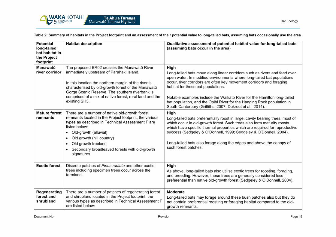
Bat Ecology
Document No. Revision Page | 9
Table 2: Summary of habitats in the Project footprint and an assessment of their potential value to long-tailed bats, assuming bats occasionally use the area
Potential long-tailed bat habitat in the Project footprint
Habitat description Qualitative assessment of potential habitat value for long-tailed bats (assuming bats occur in the area)
Manawatū river corridor
The proposed BR02 crosses the Manawatū River immediately upstream of Parahaki Island. In this location the northern margin of the river is characterised by old-growth forest of the Manawatū Gorge Scenic Reserve. The southern riverbank is comprised of a mix of native forest, rural land and the existing SH3.
High Long-tailed bats move along linear corridors such as rivers and feed over open water. In modified environments where long-tailed bat populations occur, river corridors are often key movement corridors and foraging habitat for these bat populations. Notable examples include the Waikato River for the Hamilton long-tailed bat population, and the Opihi River for the Hanging Rock population in South Canterbury (Griffiths, 2007; Dekrout et al., 2014).
Mature forest remnants
There are a number of native old-growth forest remnants located in the Project footprint, the various types as described in Technical Assessment F are listed below: • Old-growth (alluvial) • Old growth (hill country) • Old growth treeland • Secondary broadleaved forests with old-growth
signatures
High Long-tailed bats preferentially roost in large, cavity bearing trees, most of which occur in old-growth forest. Such trees also form maturity roosts which have specific thermal properties which are required for reproductive success (Sedgeley & O’Donnell, 1999; Sedgeley & O’Donnell, 2004). Long-tailed bats also forage along the edges and above the canopy of such forest patches.
Exotic forest Discrete patches of Pinus radiata and other exotic trees including specimen trees occur across the farmland.
High As above, long-tailed bats also utilise exotic trees for roosting, foraging, and breeding. However, these trees are generally considered less preferential than native old-growth forest (Sedgeley & O’Donnell, 2004).
Regenerating forest and shrubland
There are a number of patches of regenerating forest and shrubland located in the Project footprint, the various types as described in Technical Assessment F are listed below:
Moderate Long-tailed bats may forage around these bush patches also but they do not contain preferential roosting or foraging habitat compared to the old-growth remnants.

Bat Ecology
Document No. Revision Page | 10
Potential long-tailed bat habitat in the Project footprint
Habitat description Qualitative assessment of potential habitat value for long-tailed bats (assuming bats occur in the area)
• Secondary broadleaved forests and shrublands • Mānuka and kānuka shrubland • Divaricating shrubland
Ponds and wetlands
A number of wetlands occur across the Project footprint, the various types as described in Technical Assessment F are listed below: • Raupō-dominated seepage wetlands • Indigenous-dominated seepage wetlands • Pasture wetlands A number of farm ponds are also located in the study area. Abundant invertebrates gather over open water and long-tailed bats often forage over ponds and wetlands to utilise the high abundance of prey.
Moderate - Low While large, intact wetlands containing areas of open water would be considered high-value foraging habitat, the ponds and wetlands in the Project footprint are modified and are unlikely to be preferential foraging habitat (Griffiths, 2007).
Agricultural grassland
The Project area is characterised by patches of woody vegetation, ponds or wetlands within an extensive matrix of pasture grazed by both cattle and sheep.
Low Long-tailed bats are edge adapted, and preferentially forage along grassland - forest interfaces as well as other linear features within grassland such as shelterbelts (O’Donnell, 2000). However open grassland is not commonly used by long-tailed bats and is often avoided (Griffiths, 2007).

Bat Ecology
Document No. Revision Page | 11
3.5 Summary of bat values across the study area The habitat available in the Project footprint is unsuitable for short-tailed bats and no short-tailed bat records are known from within 50 km of the site despite previous survey effort. Consequently short-tailed bats are not considered further in this assessment.
The study area is located in a landscape that has the potential to support the more generalist long-tailed bats, including preferred habitat such as old-growth native forest adjacent to a large river corridor. Notwithstanding the above, considerable survey effort has been undertaken across the Designation in 2018 - 2019 and no bats have been recorded.
The results from both the project-specific bat surveys and the review of the national bat database suggest that, while a bat population is not present in the Project area, long-tailed bats are known to use the wider landscape. Taking a conservative approach (despite the absence of any such records), I have assumed that long-tailed bats may occasionally move through the Project footprint. I consider this precautionary approach is warranted given the high threat status of the species.
This conclusion was also drawn during the NoR process, and consequently the Designation Conditions include the requirement for a BMP which includes procedures for the removal of bat roosts. I agree that this is an appropriate way to manage the potential effects arising from the occasional presence of long-tailed bats in the Project footprint.
The details of the BMP are described in section 5.2 and the draft BMP is included as part of the overall Ecology Management Plan in Volume VII.
Table 3: Summary of bat values in the Project area
Species Conservation status1
Ecological value of species (as per EIANZ guidelines)
Preferred habitat available in the study area
Observed within, or in vicinity to Project area
Short-tailed bats (Mystacina tuberculata rhyacobia)
At Risk - Declining
High No No
Long-tailed bats (Chalinolobus tuberculatus)
Threatened - Nationally Critical
Very High Yes No Known to occur in the wider landscape based on review of the national bat database: • 161 records within 50
km of the Project. • The closest record is
approximately 13 km from the Project.
1 C.F.J. O’Donnell, K.M. Borkin, J.E. Christie, B. Lloyd, S. Parsons and R.A. Hitchmough (2018). Conservation status of New Zealand bats, 2017. New Zealand Threat Classification Series 21. Published by the Department of Conservation, Wellington, NZ. 4 p.

Bat Ecology
Document No. Revision Page | 12
4 Potential Effects The magnitude of potential effects of the Project on long-tailed bats was assessed following EcIAG methodology.
Potential adverse effects of the Project on long-tailed bats, if any are present, include:
• Construction phase effects
a. permanent loss of habitats;
b. injury or mortality during vegetation clearance and earthworks; and
c. disturbance during critical breeding periods.
• Operational phase effects
a. injury or mortality due to vehicle strike;
b. habitat fragmentation due to potential for the road to form a barrier to dispersing bats; and
c. disturbance or avoidance resulting from street and vehicle lights.
I stress that a broad range of potential effects are listed above, many of these are not likely to be applicable to the Project given there is no evidence that bats regularly use the area. An example is disturbance during breeding, given that there is no evidence that bats regularly use the area, it is extremely unlikely that they will be breeding in the Project footprint. The extremely low likelihood of these potential effects being realised is captured in the magnitude of effects assessment below.
I also note that the creation of new edges and the corresponding edge effects have not been considered as a potential adverse effect for long-tailed bats because they preferentially use habitat edges.
5 Effects Avoidance and Minimisation
5.1 Project shaping and avoiding and minimising effects A detailed account of the Project shaping measures are included in Technical Assessment F.
The management measures most pertinent to minimising potential effects on long-tailed bats is the reduction in impact on old-growth habitats, these measures are summarised below:
• Shifting the alignment further north between CH 5400 - CH 6000 so the road traverses the northern edge of the Western QEII2 covenant than the middle reaches of the gully. This shift reduces the area of forest directly impacted and also avoids severance of the western QEII covenant;
• The batters on the alignment traversing the Western QEII covenant have been steepened to further reduce encroachment into this high value habitat;
• Shifting the alignment further north between CH 6000 - CH 6600 to avoid severance of the Eastern QEII covenant and significantly reducing the extent of impact on this ecosystem; and
• Reduction in the physical extent of impact on the old-growth treeland containing ramarama (CH 5700 - CH 5800) through the reshaping of stormwater wetland 5.
2 The Eastern and Western QEII covenants are two forested gullies that are subject to QEII Trust open space covenants. They both extend to the south of the proposed alignment between CH 5500 - CH 6200 to the Manawatū Gorge Scenic Reserve. They are shown in Project Drawing Set

Bat Ecology
Document No. Revision Page | 13
5.2 Avoidance and minimisation of effects through the Designation Conditions The Designation Conditions stipulate the requirement of a BMP, to form part of an overall Project EMP. A draft EMP has been prepared which includes a draft BMP (refer to Volume VII - Management Plans). The key aspects of the BMP are summarised as follows:
• Annual pre-clearance bat surveys; • Dependent on the outcome of the above surveys, tree removal protocols will be undertaken to
minimise the risk of mortality to bats during vegetation clearance.
Further to the measures outlined specifically in the BMP, other measures are included in the Vegetation Clearance Management Plan that are designed to minimise unnecessary habitat removal, minimise effects on adjacent vegetation remaining, and protect and enhance remaining habitat, and restoration plantings.
These measures are summarised below and will benefit all fauna using these habitats:
• Clearly delimiting the extent of vegetation clearance and ensuring vegetation is felled into the Project footprint to minimise impacts on the remaining vegetation;
• Retention of high-value felled vegetation for use as habitat enhancement (e.g. woody debris) in restoration areas where practicable;
• Weed control and infill planting along newly created edges; • Removal and storage of top soil from impacted vegetation areas to be relocated to offset planting
areas; and • Translocation of nest epiphytes from felled trees onto established trees in enhancement areas to
promote diversity and old-growth flora characteristics in these areas.
6 Magnitude of effects The table below provide a summary of effects of the Project on the key potential long-tailed bat habitats and uses the EcIAG guidelines to assign a magnitude of effect of the Project on long-tailed bats.
It should be noted that although a number of potential impacts are listed in Table 4 below, the magnitude of effect takes into account that there is no evidence that bats use the Project footprint area. Accordingly, although potential long-tailed bat habitat is available in the area, these habitats do not constitute important habitat for a long-tailed bat population.
Table 4 also includes a summary of measures to avoid, remedy and mitigate these effects and provides a final magnitude of effect taking into account the avoidance and minimisation measures proposed. As explained in the methodology above, the magnitude of effect only takes into account the measures proposed to avoid and minimise impacts. It does not include any replacement or restoration planting. Restoration and enhancement measures are considered as part of the proposed terrestrial ecological offset and compensation package (Technical Assessment H).

Bat Ecology
Document No. Revision Page | 14
Table 4: Magnitude of effects of the Project on long-tailed bats
Description of habitats and extent of impact
Potential impacts on long-tailed bats
Avoidance and minimisation measures Magnitude of effect
6.49 ha of potentially high value habitat: • Old-growth forest
(alluvial); • Old-growth forest (hill
country); • Secondary broadleaved
forests with old-growth signatures;
• Old-growth treelands; • Mature exotic forest and
treelands; and • Manawatū River. The above habitats provide potential roosting, breeding and foraging habitat. An exception is the Manawatū River which provides a potential movement corridor as well as foraging habitat. Extent of vegetation removal of the above habitat types combined is 6.5 ha (of which 4.9 ha is exotic forest) of 21.2 ha mapped in the designation corridor. i.e. 31%. 10.85 ha of potentially moderate value habitat:
Direct impacts • Mortality of roosting
bats during vegetation clearance;
• Decreased breeding success (if maternity roosts are felled or disturbed during vegetation clearance;
• Loss of breeding and foraging habitat; and
• Mortality from vehicle strike.
Indirect impacts • Habitat
fragmentation due to potential road barrier; and
• Disturbance and potential barrier effect from street and vehicle lights.
• Clearance extent minimised through pruning as opposed to felling of old-growth trees where possible.
• Clearance located along existing habitat edges, avoiding additional fragmentation.
• Seasonal restrictions and pre-clearance protocols will be put in place to minimise harm to bats potentially roosting in old-growth vegetation. These measures will be undertaken dependent on the results of the annual pre-clearance presence/absence surveys (Refer to the draft BMP in Volume VII).
• The construction of a bridge over the Manawatū River provides commuting bats with the option of moving either under or over the carriageway - reducing potential barrier effects.
• Minimisation measures for indirect impacts such as specialised lighting design have not been deemed necessary given as bats are not using the area regularly and hence this impact is likely to be minimal.
Negligible Although a number of potential impacts have been described, the impacts would only contribute a notable effect on long-tailed bats if a population was resident in the area and regularly using these habitats. There is no evidence to suggest this is the case, instead a conservative assumption has been made that bats occasionally move through the area and use these habitats intermittently. The measures outlined in the BMP appropriately respond to the very low risk of bat injury or mortality associated with vegetation clearance. The removal of 6.5 ha of potentially high value habitat assumed to be used on occasion, will constitute only a very slight change from the existing baseline conditions. Furthermore, as there is no evidence to suggest that a population is present in the area, the removal of this habitat is assessed as having a negligible effect at the population level. This assessment also considers the context that over 1000 ha of old-growth forest comprising the Manawatū Gorge Scenic Reserve is located adjacent to the Designation that will not be impacted.

Bat Ecology
Document No. Revision Page | 15
Description of habitats and extent of impact
Potential impacts on long-tailed bats
Avoidance and minimisation measures Magnitude of effect
• Kānuka forests; • Advanced secondary
broadleaved forest; • Secondary broadleaved
forests and scrublands; • Mānuka, kānuka
shrublands; • Divaricating shrublands;
and • Farm ponds. 186.31 ha (of which 181.34 ha is improved pasture3) of potentially low value habitat: • Raupō-dominated
seepage wetlands; • Indigenous-dominated
seepage wetlands; • Pasture wetlands; and • Improved pasture
3 Note that the areal extent of improved pasture includes a small amount of other land use types such as farm tracks and weed field but these areas are very small.

Bat Ecology
Document No. Revision Page | 16
7 Assessment of effects with mitigation Based on the ecological value and magnitude of effects outlined above, the overall level of effect of the Project on long-tailed bats is assessed as Low following the EcIAG matrix 4. Table 5 below summarises how the EcIAG matrix is used to assign an overall level of effect of the Project on long-tailed bats.
Table 5: Assessment of effects of the Project on long-tailed bats, assessed using EcIAG methodology
Ecological value
Potential magnitude of effect (after avoidance and minimisation measures)
Level of residual effect with mitigation (as per the EcIAG matrix)
Long-tailed bat Very High Negligible Low
8 Additional effects management As per the EcIAG (p 84 of the guidelines), effects levels of Very Low to Low constitute a ‘not more than minor’ effect. Consequently, there are no recommendations for additional management of residual effects.
Notwithstanding the above, long-tailed bats are highly mobile and are known to occur in the wider landscape. I am unable to rule out that a population will not shift its range to include the Project footprint, although it is extremely unlikely to occur during the course of construction.
If this does happen it will be picked up in the annual pre-construction surveys outlined in the BMP and the vegetation clearance protocols will be triggered accordingly.
I note that an offset and compensation package has been developed to address residual adverse ecological effects potentially arising from the Project (refer to Technical Assessment H - Terrestrial ecology offset and compensation response for details).While this response was not prepared to address long-tailed bat effects (given the lack of residual effects), many of the measures proposed will benefit bats, in the unlikely event that they do move into the area. Below is a summary of the aspects of the offset and compensation package particularly relevant to improving long-tailed bat values:
• Revegetation of old-growth treelands; • Revegetation of old-growth forest, alluvial and hill country; • Restoration of existing degraded wetlands to improve their condition towards a like-for-like condition
compared with the indigenous wetlands impacted; and • Integrated pest management, across the revegetation areas and existing forest in the surrounding
landscape.
The EMP provides details on how restoration and enhancement planting required as part of the offset and compensation package will be achieved, in summary revegetation will include:
• Site preparation, including: a. weed management b. stock exclusion fencing (where necessary) c. the deployment of felled or fallen logs into revegetation sites d. Relocation of nest epiphytes from felled trees to mature trees in the enhancement sites
4 Refer to Appendix F.5 of Technical Assessment F

Bat Ecology
Document No. Revision Page | 17
• Planting of eco-sourced native species; • 10 years of plant maintenance, including weed management and infill planting (where necessary);
and • Covenanting to ensure long-term protection of revegetated habitats.

Bat Ecology
Document No. Revision Page | 18
9 Bibliography Dekrout A.S., B.D. Clarkson & S. Parsons (2014) Temporal and spatial distribution and habitat associations of an urban population of New Zealand long-tailed bats (Chalinolobus tuberculatus). New Zealand Journal of Zoology, 41:4, 285-295, DOI: 10.1080/03014223.2014.953551
Griffiths R.W. (2007) Activity patterns of long‐tailed bats (Chalinolobus tuberculatus) in a rural landscape, South Canterbury, New Zealand. New Zealand Journal of Zoology, 34:3, 247-258, DOI: 10.1080/03014220709510083
Leathwick, J., McGlone, M., Walker, S., & Briggs, C. 2004. Predicted Potential Natural Vegetation of New Zealand. Landcare Research, Lincoln New Zealand. Manaaki Whenua Press.
Lloyd B.D. (2001) Advances in New Zealand mammalogy 1990–2000: Short‐tailed bats. Journal of the Royal Society of New Zealand, 31:1, 59-81, DOI: 10.1080/03014223.2001.9517639
Maseyk F.J.F., Barea L.P., Stephens R.T.T., Possingham H.P., Dutson G., & Maron M. (2016) A disaggregated biodiversity offset accounting model to improve estimation of ecological equivalency and no net loss. Biological Conservation, 204, 322–332.
O'Donnell C.F.J. (2000) Influence of season, habitat, temperature, and invertebrate availability on nocturnal activity of the New Zealand long-tailed bat (Chalinolobus tuberculatus). New Zealand Journal of Zoology, 27, 207-221.
O'Donnell C.F.J. (2001) Advances in New Zealand mammalogy 1990–2000: Long‐tailed bat. Journal of the Royal Society of New Zealand, 31:1, 43-57, DOI: 10.1080/03014223.2001.9517638
O’Donnell C.F.J., K.M. Borkin, J.E. Christie, B. Lloyd, S. Parsons and R.A. Hitchmough (2018). Conservation status of New Zealand bats, 2017. New Zealand Threat Classification Series 21. Published by the Department of Conservation, Wellington, NZ. 4 p.
Sedgeley J.A & C. F. J. O’Donnell. (1999) Roost selection by the long-tailed bat, Chalinolobus tuberculatus, in temperate New Zealand rainforest and its implications for the conservation of bats in managed forests. Journal of Biological Conservation, 88, 261-276.
Sedgeley J.A & C. F. J. O’Donnell. (2004) Roost use by long-tailed bats in South Canterbury: examining predictions of roost-site selection in a highly fragmented landscape. New Zealand Journal of Ecology, 28(1), 1-18.

Page 114
APPENDIX F.2: ASSESSMENT OF EFFECTS ON TERRESTRIAL INVERTEBRATES

Te Ahu a Turanga: Manawatū Tararua Highway
Assessment of effects on terrestrial invertebrates
Document Number
Revision 1
Date 4/03/2020

Assessment of effects on terrestrial invertebrate
Document No. Revision Page | i
Document Control
Document History and Status
Revision Date Issued Author Reviewed By Approved By Status
A 4/03/2020 Dr Briar Taylor-Smith, Georgia Cummings
Dr Liz Curry Josh Markham Final
Role
Signatures:
Revision Details
Revision Details

Assessment of effects on terrestrial invertebrate
Document No. Revision Page | ii
Table of Contents Executive Summary ................................................................................................................................ 1
1 Introduction ...................................................................................................................................... 2
1.1 Purpose and scope of assessment ......................................................................................... 2
1.2 Project description ................................................................................................................... 3
1.3 Existing environment ............................................................................................................... 3
1.4 Assumptions and exclusions in this assessment .................................................................... 3
2 Methodology .................................................................................................................................... 4
2.1 Application of Ecological Impact Assessment Guidelines ...................................................... 4
2.2 Literature review ...................................................................................................................... 6
2.2.1 Information from the NoR .................................................................................................... 6
2.2.2 Information updated since the NoR..................................................................................... 7
2.3 Site Investigations ................................................................................................................... 7
2.4 Determining invertebrate values ............................................................................................. 7
3 Terrestrial invertebrate values ......................................................................................................... 8
3.1 Species values ........................................................................................................................ 8
3.2 Habitat values ........................................................................................................................ 10
3.3 Value assessment limitations ................................................................................................ 14
3.4 Proposed terrestrial invertebrate surveys ............................................................................. 14
4 Potential effects ............................................................................................................................. 15
5 Effects avoidance and minimisation .............................................................................................. 16
5.1 Project shaping and avoidance and minimising effects ........................................................ 16
5.2 Avoidance and minimisation of effects through the Designation Conditions ........................ 16
6 Assessment of effects with mitigation ........................................................................................... 18
6.1 Magnitude of effects .............................................................................................................. 18
6.2 Overall level of effects ........................................................................................................... 24
7 Measures to address residual effects that cannot be avoided or minimised ................................ 25
8 Summary of effects and conclusion .............................................................................................. 26

Assessment of effects on terrestrial invertebrate
Document No. Revision Page | 1
Executive Summary This report provides an assessment of potential effects of the Project on terrestrial invertebrates to inform the resource consent applications for the Project 'main works'.
To date, no empirical invertebrate data have been collected from within the Project footprint. However, desktop invertebrate assessments show that several species and their habitats may be present within the Project footprint, including species that are classified as ‘Threatened’ or ‘At Risk’ under the Department of Conservation’s New Zealand Threat Classification System.
Notable species that may be present include Megadromus turgidceps (beetle), Meterana grandiosa and M. exquisita (moths), Powelliphanta snails (P. marchanti, P. traversi traversi, and P. traversi tararuaensis) and Wainuia urnula (snail). Associated habitats that will be impacted include grazed mature native forest (0.35 ha proposed for removal), intact tawa forest (0.89 ha proposed for removal, including a small area of contiguous secondary forest), secondary forest with variable grazing pressure (8.01 ha proposed for removal), and divaricating shrubland (0.33 ha proposed for removal).
Ecological values have been assigned to all of the taxa identified in the desktop assessment using the Ecological Impact Assessment Guidelines (EcIAG) prepared by the Environment Institute of Australia and New Zealand (EIANZ). The habitats on the site have also been assigned a value using a combination of the EcAIG methodology and a qualitative habitat assessment developed during the Project Notice of Requirements for designations (NoR) process (Technical Assessment 6B - Boffa Miskell, 2018). As such, all species known to occur in the wider region in habitats that are present within the Project footprint, have been conservatively assessed as being present.
The paucity of site-specific information regarding the presence of terrestrial invertebrates makes assessing the actual and potential effects of the Project on invertebrates difficult. To this end, a consent condition was agreed during the NoR process that terrestrial invertebrate surveys would be undertaken prior to construction. Invertebrate surveys commenced in February 2020 and a supplementary report will be provided, detailing the results and any corresponding changes in the effects assessment within this report.
In the meantime, a conservative effects assessment has been undertaken. The overall level of effect of the Project on the potentially present ‘Threatened’ or ‘At Risk’ terrestrial invertebrates, and on the terrestrial invertebrate habitat values is assessed as being potentially Moderate to High (varying by species / habitat).
Based on the assumption that ‘Threatened’ or ‘At Risk’ terrestrial invertebrates are indeed present, a suite of effects avoidance and minimisation measures are proposed. Furthermore, an offset and compensation package, which focuses on managing residual effects associated with the loss of potential invertebrate habitat is also proposed. This package proposes a total of 45.62 ha of restoration and enhancement planting (excluding wetlands), with the exception of divaricating shrublands, all of which will be excluded from stock. Additional to this, approximately 300 ha of pulsed mammalian pest control will be undertaken across the restoration areas and into adjacent mature forest for 10 years.
Currently only small areas of forest and shrubland habitat are available within the Project footprint and designation corridor where the understorey is not heavily degraded by stock. Stock degradation likely limits the habitat availability for many of the species identified during the literature review. Consequently, we consider that the restoration and enhancement of 45.62ha of fenced-off habitat in combination with predator control will appropriately address the potential effects of the Project on terrestrial invertebrates.

Assessment of effects on terrestrial invertebrate
Document No. Revision Page | 2
1 Introduction
1.1 Purpose and scope of assessment The purpose of this report is to assess the effects of the Project on terrestrial invertebrates to inform the resource consent applications for the Project ‘main works’.
There was a fulsome assessment of most aspects of terrestrial ecology (excluding invertebrates1) and testing of the Project's ecological effects as part of the process of considering the NoRs. These NoRs are currently under appeal. The Transport Agency has asked the Environment Court, as part of those appeals, to modify the NoRs to provide for the 'Northern Alignment' on which the Project's design (and the resource consent applications) is based.
In undertaking this assessment, we have reviewed the relevant information presented through the NoR process, by the Transport Agency, the territorial authorities that processed the NoRs, and submitters on the NoRs (as listed in the 'methodology' section below). The information presented by the Transport Agency and its NoR experts has been verified through site visits and literature review. An assessment of potential effects of the Project on native terrestrial invertebrates has also been undertaken.
Further invertebrate surveys are required in order to determine the full extent of the effects. Proposed designation conditions (dated 15 October 2019) require these to be undertaken prior to the commencement of Project construction works, which is scheduled to occur later in 2020.
Beyond verifying assessments carried out by the Transport Agency and its NoR experts, this assessment takes into account more detailed Project information now available, and measures to address potential effects, including:
• The updated and more detailed design of the Project as it now stands as compared to at the council-level hearing on the NoRs, including the updated Project alignment, as well as the design of associated works (shared use path, spoil sites, and lookouts) as described in the Design and Construction Report (Volume II) and shown in the Project Drawing Set;
• The regional consents being sought to enable the Project; • The management actions outlined in the proposed management plans, particularly the Terrestrial
Invertebrate Management Plan (TIMP) included within the overall Ecology Management Plan (EMP); and
• The terrestrial ecology offset and compensation package outlined in Technical Assessment H (Terrestrial offset and compensation).
Instances where this assessment of the potential effects of the Project differs from the assessment at the NoR stage are highlighted. Such differences result from new information being obtained, and the more detailed level of design now confirmed and proposed through the resource consent applications.
This assessment is limited to the potential effects on native terrestrial invertebrates; refer to the following technical assessments for information on other aspects of ecology:
• Terrestrial vegetation, lizards and avifauna - Technical Assessment F by Dr Baber; and • Bats - Technical Assessment F.1 by Ms Cummings; and • Aquatic ecology - Technical Assessment G by Ms Quinn 1 To date, no empirical invertebrate data have been collected from within the Project footprint and further surveys are required. Preliminary desktop invertebrate assessments show that several ‘Threatened’ and ‘At Risk’ invertebrate species and their habitats may be present within the Project footprint.

Assessment of effects on terrestrial invertebrate
Document No. Revision Page | 3
1.2 Project description Refer to the “Project description” section in Technical Assessment F.
1.3 Existing environment Refer to the “Project description” section in Technical Assessment F.
1.4 Assumptions and exclusions in this assessment This assessment addresses the effects on native bats anticipated from the 'main works' of the Project as detailed in the Project Drawing Set and summarised in the Design and Construction Report (DCR). The impacts are based the potential habitat removal and modification associated with the proposed road alignment plus all associated temporary and permanent infrastructure, and includes a construction buffer (described in Technical Assessment F), henceforth referred to as the “Project footprint”.

Assessment of effects on terrestrial invertebrate
Document No. Revision Page | 4
2 Methodology
2.1 Application of Ecological Impact Assessment Guidelines As per the previous technical assessments prepared during the NoR process, the invertebrate species values have been characterised and assessed, along with the effects of the Project on these values, using current best practice methods outlined in the Environmental Institute of Australia and New Zealand (EIANZ) Ecological Impact Assessment Guidelines (EcIAG) document (EIANZ, 2018).
Refer to the “methodology” section in Technical Assessment F for a detailed explanation of the application of the EcIAG. The guidelines have generally been applied for this assessment as described in Technical Assessment F. A single departure is the criteria used to assign habitat value. Instead of using the criteria in Table 4 in the EcAIG, the ecological value scoring process described in Technical Assessment 6B (Boffa Miskell, 2018) has been used (Table 2-1). This involves using the known habitat preferences of terrestrial invertebrates to make a qualitative assessment (Low, Moderate, High) of the habitat available on site.
This method is considered appropriate given that no targeted surveys of terrestrial invertebrates have been undertaken since the Boffa Miskell assessment was carried out. The factors considered by the Boffa Miskell scoring process are:
• Extent of browsing/grazing; • Vegetation patch size, shape and associated edge effects; • Vascular plant diversity; • Isolation; • Invasion by non-native plants; • Presence of mammalian predators; and • “Spill over effects” (i.e. movement of invertebrates) from forest patches into adjacent exotic
pasture. Where desktop review has suggested that notable terrestrial invertebrate species may be utilising a given habitat, the habitat value assigned in Technical Assessment 6B (Boffa Miskell, 2018) has been updated to reflect the potential presence of this notable taxa. This updated value is based on methods in the EcAIG, and takes into account the individual threat status of each invertebrate species.
It is important to note that while offsetting and compensation form a key component of the effects management framework for this Project, these measures do not reduce the overall level of effect as determined using the EcIAG methodology.

Assessment of effects on terrestrial invertebrate
Document No. Revision Page | 5
Table 2-1: Assignment of values within the subject site to habitats (from Technical Report 6B - Boffa Miskell, 2018).

Assessment of effects on terrestrial invertebrate
Document No. Revision Page | 6
2.2 Literature review
2.2.1 Information from the NoR As noted above, this report relates directly to the consideration of the effects of the Project on terrestrial invertebrates through the NoR process. As such, the reports below have been reviewed:
• Technical Report 6: Terrestrial ecology, and its primary appendices. a Assessment of Terrestrial Vegetation and Habitats (Dr Adam Forbes, Forbes Ecology,
2018) (“Technical Assessment 6A”); b Report 6B: Terrestrial Fauna Ecological Effects Assessment Technical Report (Boffa Miskell
2018, prepared by Mr Andrew Blayney and Ms Karin Sievwright) (“Technical Assessment 6B”);
Relevant evidence presented at the council-level hearing on the NoRs, by the Transport Agency and others has also been reviewed, including:
• Statement of Evidence of Dr Forbes dated 8 March 2019, and the addendum dated 25 March 2019.
• Statement of Evidence of Mr Andrew Blayney (who focused on terrestrial fauna) dated 8 March 2019, and the addendum dated 25 March 2019.
• Statement of Section 42A Technical Evidence of Mr James Lambie dated 1 March 2019. • Statement of Evidence of Dr Timothy Martin on behalf of the Director-General of Conservation
dated 15 March 2019, and the addendum dated 4 April 2019. • The Joint Witness Statements prepared by Forbes and Martin (22 February 2019) and by Forbes,
Blayney and Lambie (18 March 2019). The following have also been reviewed:
• The recommendation of the council-level hearing panel to the Transport Agency in respect of the NoRs; and
• The Transport Agency’s subsequent decision to confirm the NoRs subject to conditions dated 7 June 2019, and the accompanying condition set.
Following Environment Court mediation processes, the Transport Agency has asked the Court to modify the NoRs to reflect the now proposed ‘Northern Alignment’. Dr Forbes and Mr Blayney prepared an addendum to Technical Report 6 addressing the Northern Alignment (as compared to the originally confirmed alignment) including in respect of invertebrates. That addendum report has been reviewed; it represents the last substantive assessment in respect of invertebrates carried out during the NoR process.
The Transport Agency has also agreed amendments to the decision-version of the designation conditions with the territorial authorities and other parties. The updated agreed conditions were lodged with the Environment Court on 15 October 2019; these conditions are referred to in this report as the “Designation Conditions”. The Designation Conditions have been reviewed and a draft TIMP has been prepared based on Condition 23 of the Designation Conditions. The avoidance and minimisation measures in the TIMP are taken into account in thee assessment of effects outlined this report.
Overall, this assessment updates NoR Technical Assessment 6 based on:
• the updated alignment and more detailed design information; • the regional consents being sought to enable the Project; and • management actions to avoid or minimise effects as set out in the TIMP, the EMP more broadly,
and related management plans.

Assessment of effects on terrestrial invertebrate
Document No. Revision Page | 7
2.2.2 Information updated since the NoR As noted above, this report relates directly to the consideration of the effects of the Project on terrestrial invertebrates through the NoR process. As such, the reports below have been reviewed:
In addition to Technical Assessment 6B (Boffa Miskell, 2018), the ecological databases listed below were also reviewed to ensure the most recent data available was included in this assessment. The databases reviewed were:
• iNaturalist invertebrate records (accessed on 17 December 2019); and • NZ mollusca (accessed on 21 January 2020).
2.3 Site Investigations As described in Technical Assessments 6A (Forbes Ecology, 2018) and 6B (Boffa Miskell, 2018), extensive habitat investigations were carried out to inform the assessment of effects for the NoR process.
No empirical invertebrate data have been collected from within the Project footprint and, to date, no ‘Threatened’ or ‘At Risk’ invertebrate species have been observed within the Project footprint.
As per the Designation Conditions, further invertebrate surveys prior to the commencement of construction works are being undertaken to determine:
• invertebrate community composition; and • the presence of ‘At Risk’ or ‘Threatened’ taxa (as defined by the Department of Conservation’s
New Zealand Threat Classification System).
If ‘At Risk’ or ‘Threatened’ invertebrate taxa are found to be present, the draft TIMP will be updated to detail management actions applicable to these taxa.
2.4 Determining invertebrate values For the purpose of this assessment, a precautionary approach has been applied in terms of determining invertebrate values and potential effects by assuming that all ‘Threatened’ and ‘At Risk’ species that are potentially present in the wider area (as determined through desktop review), may be present on site.
Based on this assumption, the likelihood of different ecosystem types supporting invertebrates has been assessed. This assessment is based on the ecology of the different invertebrate species, and the habitat value and landscape context of the ecosystem types.

Assessment of effects on terrestrial invertebrate
Document No. Revision Page | 8
3 Terrestrial invertebrate values There is limited information available on the invertebrate community in the area. Therefore, a conservative approach has been taken to assess terrestrial invertebrate species and habitat values within the Project area in the absence of survey work to determine the invertebrate community assemblage.
This approach is consistent with the method applied during the NoR process, in advance of the results of surveys being available. Once those results are available the intention is that an addendum report will be produced to update the invertebrate values as presented in this report.
3.1 Species values Literature review has shown that several ‘Threatened’ or ‘At Risk’ terrestrial invertebrates may be present in the Project area. These are listed in Table 3-1.
Following the EIANZ guidelines, the ecological value of terrestrial invertebrate species that are At Risk – Relict is considered as ‘Moderate’. The ecological value of terrestrial invertebrate species that are Threatened – Nationally Endangered or Threatened – Serious Decline is considered as ‘Very High’.
Two invertebrate species (both of which have not been formally assigned a threat status) were addressed in Technical Assessment 6B (Boffa Miskell, 2018) (Megadromus turgidceps, a beetle) and the evidence of Dr Martin (paragraphs 3.4 and 7.16; Wainuia urnula, a snail2). These two species have been included in the assessment of ecological effects and for the purpose of this assessment, these species have been assigned the threat status ‘Locally Uncommon’.
The moth species Asaphodes stinaria (Threatened – Nationally Vulnerable) was mentioned in Dr Martin’s NoR evidence (paragraph 7.19) and Mr Blayney’s rebuttal evidence stated that the TIMP would include surveys for this species (paragraph 11). The One Plan 2014 (Schedule F: Indigenous Biological Diversity) does not make any reference to this species. Although this species was formerly widespread, there is no evidence to suggest that this moth is currently present in the vicinity of the Manawatū Gorge3,4. For these reasons, this species has been excluded in this assessment of effects.
2 Note that Dr Martin referred only to ‘Wainuia’; NZ Mollusca indicates that Wainuia urnula is the only Wainuia species present in the Manawatū region. 3 Patrick, B; Dugdale, J.S. (2000). Conservation status of the New Zealand Lepidoptera. Wellington, New Zealand: Department of Conservation. p. 20. 4 Hoare, R. (2020) Pers. comm. “I don’t think A. stinaria is likely to be present in the Manawatu-Wanganui region, although it probably was in the past. It seems to have retreated completely to strongholds in the western South Island where it is very local.”

Assessment of effects on terrestrial invertebrate
Document No. Revision Page | 9
Table 3-1: Summary of notable invertebrates that could be present in the Project area based on literature review.
Species Conservation Status
NoR reference Habitat preferences
Chainages of potentially suitable habitat
Ecological value of species (as per EIANZ guidelines)
Megadromus turgidceps (beetle)
Not classified – possibly locally uncommon
Technical Assessment 6B (Boffa Miskell, 2018)
Native forest with an intact understory1.
Chainage: 5500 – 5900
Moderate
Meterana grandiosa (moth)
At Risk - Relict Dr Martin’s evidence, paragraph 7.19. Mr Blayney’s rebuttal evidence paragraph 11.
Divaricating shrubs including Olearia species2.
Chainage 9300 - 9600; 9900 - 10000
Moderate
Meterana exquisita (moth)
At Risk - Relict Moderate
Powelliphanta traversi traversi (snail)
Threatened - Nationally Endangered
Dr Martin’s evidence, paragraph 3.4. Mr Blayney’s rebuttal evidence paragraph 11.
Powelliphanta snails are generally associated with forest areas with large accumulations of moist leaf litter. Also closely associated with calcium rich soils3.
Chainage 5500 – 5900
Very high
Powelliphanta traversi tararuaensis (snail)
Threatened - Nationally Endangered
Chainage 5500 – 5900
Very high
Powelliphanta marchanti (snail)
Threatened – Serious Decline
Chainage 5500 – 5900
Very high
Wainuia urnula (snail)
Not classified – possibly locally uncommon
Dr Martin’s evidence, paragraph 3.4. Mr Blayney’s rebuttal evidence paragraph 11.
Recorded in damp leaf litter and stable rock piles in intact and modified forest4.
Chainage: 4100 – 4500; 5500 – 5900; 9900 – 12800
Moderate
1Cartellieri & Gabor (2003). Seasonal dynamics and reproductive phenology of ground beetles (Coleoptera, Carabidae) in fragments of native forest in the Manawatu, North Island, New Zealand, New Zealand Journal of Zoology, 30:1, 31-42. 2Patrick B. (2000). Lepidoptera of small-leaved divaricating Olearia in New Zealand and their conservation priority. Science for Conservation 168. Department of Conservation, Wellington, NZ. 3M. J. Meads , K. J. Walker & G. P. Elliott (1984) Status, conservation, and management of the land snails of the genus Powelliphanta (Mollusca: Pulmonata), New Zealand Journal of Zoology, 11:3, 277-306. 4Efford, M. (1998). Distribution and status of native carnivorous land snails in the genera Wainuia and Rhytida. Science for Conservation 101. Department of Conservation, Wellington, NZ.

Assessment of effects on terrestrial invertebrate
Document No. Revision Page | 10
3.2 Habitat values The approach used in Technical Assessment 6B (Boffa Miskell, 2018) for the assessment of terrestrial invertebrate habitat values has been reviewed and is considered a sound methodology in the absence of site surveys.
The areas of ecological value with regard to terrestrial invertebrates are summarised in Table 3-2. This table is a summary of:
• The summary of terrestrial invertebrate habitat values in Technical Assessment 6B (Boffa Miskell, 2018).
• Updated to include a higher ecological value for divaricating shrubland given the potential records of At Risk Meterana species being associated with this habitat (paragraph 7.19 of Dr Martin’s evidence, paragraph 18 of Mr Blayney’s rebuttal evidence).
• The potential for these vegetation types to support ‘Threatened’ or ‘At Risk’ fauna (as per Table 5 of the EcIAG).
As discussed in section 6 below, these habitats make up only a small proportion of the overall Project footprint.

Document No. Revision Page | 11
Table 3-2: Summary of the ecological value of vegetation types in the Project footprint with regard to terrestrial invertebrates. Ecological values were assigned based on the methodology in Technical Report 6B (Boffa Miskell, 2018) and EIANZ guidelines.
Vegetation types Habitat attributes as per NoR Technical Assessment 6B (Boffa Miskell, 2018)
Value as per NoR Technical Assessment 6B (Boffa Miskell, 2018 and Mr Blayney’s rebuttal evidence)
‘Threatened’ or ‘At Risk’ species that may be present within this habitat
Ecological Value (if ‘Threatened’ or ‘At Risk’ invertebrates from Table 3-1 are present). See methodology section for how ecological value was assigned.
Grazed mature native forest5: • Old-growth forest
alluvial • Secondary
broadleaved forests with old-growth signatures
Grazing pressure high, but some areas possibly protected. Disturbed forest floor with little debris. Small-medium size, poor linkage. Large areas of full canopy closure, developing sub-canopy and ground flora, pasture grasses absent.
Moderate – low Wainuia urnula (snail – possibly locally uncommon). Found in forest habitats with accumulation of some leaf litter only.
Moderate
Intact tawa forest: • Old-growth forest
hill country • Advanced
secondary broadleaved forest6
Mature forest with high naturalness, diversity and pattern. Little grazing pressure.
High Megadromus turgidceps (beetle; possibly locally uncommon); Powelliphanta traversi traversi (snail; Threatened – Nationally Endangered); Powelliphanta traversi tararuaensis (snail; Threatened - Nationally Endangered); Powelliphanta marchanti
Very High
5 Note that Technical Report 6B (Boffa Miskell, 2018) included wetland and mānuka kānuka shrublands within this category. Given that the literature review has found no evidence that ‘Threatened’ or ‘At Risk’ terrestrial invertebrate species are present within wetland or mānuka kānuka shrubland habitats within the vicinity of the Project area, these two habitat types have been excluded from this category, and are combined with ‘the rest of the designation’. 6 Included because the area impacted has direct connectivity to the old-growth forest (hill country) and stock are excluded.

Document No. Revision Page | 12
Vegetation types Habitat attributes as per NoR Technical Assessment 6B (Boffa Miskell, 2018)
Value as per NoR Technical Assessment 6B (Boffa Miskell, 2018 and Mr Blayney’s rebuttal evidence)
‘Threatened’ or ‘At Risk’ species that may be present within this habitat
Ecological Value (if ‘Threatened’ or ‘At Risk’ invertebrates from Table 3-1 are present). See methodology section for how ecological value was assigned.
Intact sub-canopy, abundant epiphytes and ground flora. Undisturbed forest floor with abundant debris. Compact shape and linked to intact forest.
(snail;Threatened – Serious Decline); Wainuia urnula (snail; possibly locally uncommon).
Secondary forest with variable grazing pressure: • Secondary
broadleaved forests and shrublands
• Kānuka forests
Secondary forest with moderate to low naturalness, diversity and pattern. Grazing pressure generally low although some areas appear more degraded by stock access, particularly around the western rise area (chainage 3900 - 4400). Developing sub-canopy and ground flora, pasture grasses prevalent in some areas. Forest floor with some debris.
Moderate Wainuia urnula (snail; possibly locally uncommon).
Moderate

Document No. Revision Page | 13
Vegetation types Habitat attributes as per NoR Technical Assessment 6B (Boffa Miskell, 2018)
Value as per NoR Technical Assessment 6B (Boffa Miskell, 2018 and Mr Blayney’s rebuttal evidence)
‘Threatened’ or ‘At Risk’ species that may be present within this habitat
Ecological Value (if ‘Threatened’ or ‘At Risk’ invertebrates from Table 3-1 are present). See methodology section for how ecological value was assigned.
Divaricating shrublands
Grazed pasture or graze-tolerant shrubs. Grazing pressure moderate to high. Little to no sub-canopy and ground cover other than pasture grasses and bare ground.
–High (Mr Blayney’s rebuttal evidence, paragraph 18).
Meterana grandiosa (moth; At Risk - Relict); Meterana exquisita (moth; At Risk - Relict)
High
Rest of designation, including: wetlands, mānuka kānuka shrublands, and old-growth treelands
Grazed pasture or graze-tolerant shrubs. Grazing pressure moderate to high. Little to no sub-canopy and ground cover other than pasture grasses and bare ground.
Low – negligible NA Low – negligible
Document No. Revision Page | 14
3.3 Value assessment limitations Assigning ecological value based on the potential presence of ‘Threatened’ or ‘At Risk’ species in
Table 3-1 represents a highly conservative approach. This is given that many of the species identified during the literature review are only known from isolated populations across the wider region that have never been observed within the Project area, or from old records.
Through our more detailed literature review we have identified no further invertebrate taxa than those discussed during the NoR process. However, we have used the literature to pinpoint to species level the taxa that are most likely to be present within the Project area that were only identified to genus level during the NoR process.
Designation Condition 23 (agreed between the Transport Agency, territorial authorities, DOC and others) requires terrestrial invertebrate surveys to be undertaken prior to construction, in order to allow a more specific assessment of terrestrial invertebrates values and effects.
3.4 Proposed terrestrial invertebrate surveys To fulfil the aforementioned condition, a draft methodology for invertebrate surveys has been prepared and these surveys are being undertaken in 2020. The objectives of these surveys are to determine:
• Invertebrate community composition; • The presence of ‘At Risk’ or ‘Threatened’ taxa (as defined by the Department of Conservation’s
New Zealand Threat Classification System). Following a precautionary approach, these surveys will be undertaken within representative vegetation with invertebrate habitat values of moderate and above (see Table 3-2). These vegetation types are:
• Old-growth forest alluvial (part of the ‘grazed mature native forest’ habitat type, 0.10 ha proposed for removal of 0.35 ha of the broader habitat type)
• Old-growth forest hill country (part of the ‘intact tawa forest’ habitat type, 0.85 ha proposed for removal of 0.89 ha of the broader habitat type);
• Secondary broadleaved forests and shrublands (part of the ‘secondary forest with variable grazing pressure’ habitat type, 6.71 ha proposed for removal of 8.01 ha of the broader habitat type); and
• Divaricating shrubland (0.33 ha proposed for removal). Technical Assessment F (Terrestrial vegetation, lizards and avifauna) describes in more detail the habitat types occurring across the Project footprint.
The draft invertebrate survey methodology is included in the TIMP, which is part of the overall EMP (refer to Volume VII - Management Plans). Three specific types of surveys are proposed:
• Flight intercept trapping, in the old-growth forest and secondary broadleaved forests and shrublands;
• Light trapping, in respect of Metarana grandiosa and Meterana exquisita moth species in divaricating shrubland; and
• Powelliphanta snail habitat surveys in in the old-growth forest hill country. Flight intercept trapping and snail habitat surveys are currently being undertaken (February 2020). Surveys for Meterana moths will be undertaken from mid-April to early June (for M. grandiosa) and August to December 2020 (for M. exquisita). M. exquisita surveys will take place preferably in September or October 2020 when adults of this species are most abundant.

Document No. Revision Page | 15
4 Potential effects The magnitude of potential effects of the Project on terrestrial invertebrates was assessed following a combination of the EcIAG methodology and the methodology used in Technical Assessment 6B (Boffa Miskell, 2018). This method is considered appropriate in the absence of further field surveys. See section 2.1 for further detail.
The magnitude of effects assessment has been undertaken taking into account a suite of effects avoidance and minimisation measures (see section 5).
Potential adverse effects of the Project on terrestrial invertebrates include:
• direct mortality; • construction noise, vibration, light and dust disturbance; • permanent loss of habitats; and • modification of remaining habitat through:
a fragmentation and isolation; b edge effects; and c increased presence of and likelihood of invasion by non-native plant and animal species.

Document No. Revision Page | 16
5 Effects avoidance and minimisation
5.1 Project shaping and avoidance and minimising effects A detailed account of the Project shaping measures are included in Technical Assessment F.
The management measures most pertinent to minimising potential effects on terrestrial invertebrates is the reduction in impact on old-growth habitats. The relevant measures in this regard are summarised below:
• Shifting the alignment further north between CH 5400 - CH 6000 so the road traverses the northern edge of the Western QEII covenant than the middle reaches of the gully. This shift reduces the area of forest directly impacted and also avoids severance of the western QEII covenant.
• The batters on the alignment traversing the Western QEII covenant have been steepened to further reduce encroachment into this very high value habitat.
• Shifting the alignment further north between CH 6000 - CH 6600 to avoid severance of the Eastern QEII covenant and significantly reducing the extent of impact on this ecosystem.
• Avoidance of the gully at CH 9200 - CH 9400, which contains a number of divaricating shrubland patches. This gully is no longer the location of an indicative spoil site.
• Reduction in the physical extent of impact on the old-growth treeland containing ramarama (CH 5700 - CH 5800) through the reshaping of stormwater wetland 5.
5.2 Avoidance and minimisation of effects through the Designation Conditions Further to requiring surveys to be carried out, the Designation Conditions require that, If ‘At-Risk’ or ‘Threatened’ terrestrial invertebrates are detected during pre-construction invertebrate surveys, the TIMP will be updated with measures to avoid and/or minimise adverse impacts on terrestrial invertebrates.
In particular, following the pre-construction surveys Designation Condition 23 b) vi) requires the TIMP to be updated as follows:
• Identify vegetation or habitats that should be avoided in the first instance; • Outline the optimal timing of vegetation clearance; • Describe the methods of direct invertebrate management; • Identify areas where measures to manage enabling or construction works activities apply; and • Set out approaches to the restoration of invertebrate taxa/community composition in planting and
retirement areas required by Designation Condition 24, including but not limited to: a Wood disk stepping stones and long grass or shrubland corridors; b The salvage and transfer of soils, coarse woody material or debris and leaf litter; c Detailed measures to create and/or restore habitats for populations of ‘At-Risk’ or
‘Threatened’ taxa impacted by the Project; d Monitoring protocol for populations of ‘At-Risk’ or ‘Threatened’ taxa impacted by the Project,
where monitoring forms part of the measures determined by Condition 24(b); and e Biosecurity measures required in carrying out these activities.
Subject to the results of the pre-construction surveys (discussed above), the TIMP will be updated accordingly (at this stage the TIMP is focussed primarily on the methodology for the pre-construction surveys).

Document No. Revision Page | 17
Other measures are included in the Vegetation Clearance Management Plan that are designed to minimise unnecessary habitat removal, minimise effects on adjacent vegetation remaining, and protect and enhance remaining habitat and replacement plantings.
These measures are summarised below and will benefit all fauna (including terrestrial invertebrates) using these habitats:
• Clearly delimiting the extent of vegetation clearance and ensuring vegetation is felled into the Project footprint to minimise impacts on the remaining vegetation;
• Retention of high-value felled vegetation for use as habitat enhancement (e.g. woody debris) in restoration areas where practicable;
• Weed control and infill planting along newly created edges; • Removal and storage of top soil from impacted vegetation areas to be relocated to offset planting
areas; and • Translocation of epiphytes from felled trees onto established trees in enhancement areas to
promote diversity and old-growth flora characteristics in these areas.

Document No. Revision Page | 18
6 Assessment of effects with mitigation
6.1 Magnitude of effects The proposed designation corridor covers 340 ha, while the Project footprint covers 195 ha7. The key habitats for terrestrial invertebrates are listed below, making up a small proportion of the overall Project footprint (less than 10 ha) (refer to Table 3-2 and Table 6-1 for more detail):
• Grazed old-growth forest, including secondary broadleaved forests with old-growth signatures (0.35 ha proposed for removal);
• Intact old-growth forest, including advanced secondary broadleaved forest (0.89 ha proposed for removal)
• Secondary forest with variable grazing pressure (8.01 ha proposed for removal comprising the habitat types: secondary broadleaved forests and shrublands, and kānuka forests)
• Divaricating shrublands (0.33 ha proposed for removal);
Table 6-1 uses the EcIAG guidelines to provide a summary of the magnitude of the effects of the Project on these potential terrestrial invertebrate habitats, as well as on the specific terrestrial invertebrates discussed above.
Measures to avoid, remedy and mitigate potential effects on terrestrial invertebrates are summarised as follows:
• Clearance extent minimised through pruning as opposed to felling of old-growth trees where possible;
• Clearance extent along habitat edges, avoiding fragmentation; • Seasonal restrictions and/or pre-clearance protocols will be put in place; • Epiphyte and coarse woody debris relocation will reduce harm to invertebrates and provide habitat
enhancement in adjacent forest (Refer to draft EMP in Volume VII); • Dust suppression is proposed across the Project during construction and monitoring will be
undertaken at old-growth forest (hill country) adjacent to Project footprint (refer to Technical Report E);
• Weed control and enrichment planting to be undertaken in newly created edges (Refer to draft EMP in Volume VII); and
• Replacement planting of indigenous vegetation.
Note that these measures may be updated following the baseline invertebrate surveys.
Table 6-1 provides a magnitude of effect taking into account the mitigation proposed. As explained in the methodology above, the magnitude of effect only takes into account the measures proposed to avoid, minimise and mitigate for effects. It does not include any replacement or restoration planting as these measures are considered as part of the proposed offset and compensation measures.
Again, this is a conservative assessment of effects, in advance of specific survey results. The intention is that this effects assessment will be updated via an addendum report once survey results are available.
7 Note that part of the Project footprint, namely some of the spoil sites, extend beyond the Designation. The only habitat types impacted outside of the Designation are grassland and mānuka and kānuka shrublands.

Document No. Revision Page | 19
Table 6-1: Magnitude of effect on terrestrial invertebrates
Value
(Noteworthy terrestrial invertebrate species and key habitats) 8
Description of habitats and extent of impact
Potential direct impacts on invertebrates
Potential indirect impacts on invertebrates
Avoidance, minimisation and mitigation measures
Magnitude of effect (after avoidance and minimisation measures)
Invertebrate Species
Megadromus turgidceps (beetle)
Removal of 0.89 ha of old growth tawa forest including the contiguous advanced secondary broadleaved forest (Chainage 5500 – 5900)
Mortality, disturbance to foraging and breeding behaviours through dust, light and vibration, loss of habitat
Modification of remaining habitat through: Fragmentation and isolation; edge effects; and increased presence of and likelihood of invasion by non-native plant and animal species.
Clearance extent minimised through pruning as opposed to felling of old-growth trees where possible. Clearance extent along habitat edges, avoiding fragmentation. Seasonal restrictions and/or pre-clearance protocols will be put in place. Epiphyte and coarse woody debris relocation will reduce harm to invertebrates and provide habitat enhancement in adjacent forest (Refer to draft EMP in Volume VII). Dust suppression is proposed across the Project
Potentially9 Moderate
Powelliphanta snails
Potentially Moderate
Meterana moths Removal of 0.33 ha of divaricating shrubland (Chainage 9300 - 9600)
Potentially Moderate
Wainuia urnula (snail)
Removal of 9.24 ha of intact and modified forest with an accumulation of some leaf litter. This is a combination of invertebrate habitats described in Table 3-2 (and below) and
Potentially Moderate
8 Note that these habitat types have been included within this assessment because of the potential that terrestrial invertebrate species not previously identified during the NoR and consenting processes may be found within these habitats.
9 The term ‘potentially’ has been used to describe the magnitude of effect, as it is unclear whether these species are present, and, if they are present, details of their population sizes and habitat utilization within the area are unknown.

Document No. Revision Page | 20
Value
(Noteworthy terrestrial invertebrate species and key habitats) 8
Description of habitats and extent of impact
Potential direct impacts on invertebrates
Potential indirect impacts on invertebrates
Avoidance, minimisation and mitigation measures
Magnitude of effect (after avoidance and minimisation measures)
comprises these ecosystem types: • Old-growth forest
(alluvial) • Old-growth forest (hill
country) • Secondary
broadleaved forests with old-growth signatures
• Advanced secondary broadleaved forest
• Secondary broadleaved forests and scrublands
• Kānuka forest (CH 4100 – 4500; 5500 – 5900; 9900 – 12800)
during construction and monitoring will be undertaken at old-growth forest (hill country) adjacent to Project footprint (refer to Technical Report E) Weed control and enrichment planting to be undertaken in newly created edges (Refer to draft EMP in Volume VII). If Meterana spp. recorded in the area - a grazing or mowing regime will be continued across the remaining divaricating shrubland patches within the designation to promote the areas remaining in a stalled successional trajectory dominated by divaricating shrubs .

Document No. Revision Page | 21
Value
(Noteworthy terrestrial invertebrate species and key habitats) 8
Description of habitats and extent of impact
Potential direct impacts on invertebrates
Potential indirect impacts on invertebrates
Avoidance, minimisation and mitigation measures
Magnitude of effect (after avoidance and minimisation measures)
Key Invertebrate Habitats10
Grazed mature native forest11: • Old-growth
forest alluvial • Secondary
broadleaved forests with old-growth signatures
Extent of vegetation removal of this habitat is 0.35 ha of 6.41 ha mapped in the Designation i.e. 5.4%. Areas of impact: • Old growth forest
alluvial (CH 4100 – 4500);
• Secondary broadleaved forests with old-growth signatures (CH 7300, CH 10400 - 10600)
As above As above As above Potentially Moderate
10 These habitats have been included in the effects assessment to recognise that there may be other notable invertebrate species that have been not been captured in the literature review and therefore not accounted for above. Hence the removal of these habitats may have additional impacts on the invertebrate community not captured by a species-specific assessment approach. 11 Note that Technical Report 6B (Boffa Miskell, 2018) included wetland and mānuka kānuka shrublands within this category and referred to it as “grazed mature native forest and scrub”. Given that the literature review has found no evidence that Threatened or At Risk terrestrial invertebrate species are present within wetland or mānuka kānuka shrubland habitats within the vicinity of the Project area, these two habitat types have been excluded from this category, and combined with ‘the rest of the designation’.

Document No. Revision Page | 22
Value
(Noteworthy terrestrial invertebrate species and key habitats) 8
Description of habitats and extent of impact
Potential direct impacts on invertebrates
Potential indirect impacts on invertebrates
Avoidance, minimisation and mitigation measures
Magnitude of effect (after avoidance and minimisation measures)
Intact tawa forest: • Old-growth
forest hill country
• Advanced secondary broadleaved forest12
Extent of vegetation removal of the above habitat types combined is 0.89 ha of 1.79 ha mapped in the Designation i.e. 49.7%. Note that the designation has been specifically constrained around the old-growth forest hill country and thus this is a highly conservative representation of the % impact on these habitat types in the immediate area. Areas of impact: • Old-growth forest hill
country (CH 5500 - 5700)
• Advanced secondary broadleaved forest (CH 5500 - 5600)
Potentially Moderate
12 Included because the area impacted has direct connectivity to the old growth forest hill country and stock are excluded.

Document No. Revision Page | 23
Value
(Noteworthy terrestrial invertebrate species and key habitats) 8
Description of habitats and extent of impact
Potential direct impacts on invertebrates
Potential indirect impacts on invertebrates
Avoidance, minimisation and mitigation measures
Magnitude of effect (after avoidance and minimisation measures)
Divaricating shrublands
Extent of vegetation removal is 0.33 ha of 0.50 ha mapped in the Designation i.e. 66.5% Area of impact: CH 9300 - 9600; 9900 - 10000
Potentially Moderate
Secondary forest with variable grazing pressure: • Secondary
broadleaved forests and shrublands
• Kānuka forest
Extent of vegetation removal is 8.01 ha of 18.68 ha mapped in the Designation i.e. 43%. Ares of impact: • Secondary
broadleaved forests and shrublands (CH 3800 - 4400; 9800 –12600)
• Kānuka forest (CH 3900 - 4100; 5500; 7200 - 7300)
Potentially Moderate

Assessment of effects on terrestrial invertebrate
Document No. Revision Page | 24
6.2 Overall level of effects As set out in Table 6-1 above, the magnitude of effect of the Project on terrestrial invertebrates has been assessed as potentially Low to Moderate using the EcIAG methodology. The term ‘potentially’ has been used to describe the magnitude of effect, as it is unclear whether these species are present, and, if they are present, details of their population sizes and habitat utilization within the area are unknown.
Based on the ecological vale and magnitude of effects outlined above, the overall level of effect of the Project on terrestrial invertebrates is assessed as potentially Moderate to High using the EcIAG matrix. Table 6-2 below summarises how the EcIAG matrix is used to assign an overall level of effect of the Project on terrestrial invertebrates.
Table 6-2: Assessment of effects of the Project on terrestrial invertebrates
Species/habitat Ecological value (as per EIANZ guidelines)
Potential magnitude of effect (after avoidance, minimisation and mitigation measures)9
Level of residual effect13
Megadromus turgidceps (beetle) Moderate Potentially Moderate Potentially Moderate
Meterana grandiosa (moth) Moderate Potentially Moderate Potentially Moderate
Meterana exquisita (moth) Moderate Potentially Moderate Potentially Moderate
Powelliphanta traversi traversi (snail)
Very high Potentially Moderate Potentially High
Powelliphanta traversi tararuaensis (snail)
Very high Potentially Moderate Potentially High
Powelliphanta marchanti (snail) Very high Potentially Moderate Potentially High Wainuia urnula (snail) Moderate Potentially Moderate Potentially
Moderate Grazed mature native forest and scrub5 : • Old-growth forest alluvial • Secondary broadleaved forests
with old-growth signatures
Moderate Potentially Moderate Potentially Moderate
Intact tawa forest: • Old-growth forest hill country • Advanced secondary
broadleaved forest12
Very High Potentially Moderate Potentially High
Divaricating shrublands High Potentially Moderate Potentially High Secondary forest with variable grazing pressure: • Secondary broadleaved forests
and shrublands • Kānuka forest
Moderate Potentially Moderate Potentially Moderate
13 The term ‘potentially’ has been used to describe the magnitude of effect, as it is unclear whether these species are present, and, if they are present, details of their population sizes and habitat utilization within the area are unknown.

Assessment of effects on terrestrial invertebrate
Document No. Revision Page | 25
7 Measures to address residual effects that cannot be avoided or minimised
As per the EcIAG (p 84 of the guidelines), effects levels of Moderate and above constitute residual effects that should be either reduced through further avoidance and minimisation, or offset or compensation.
Some old-growth forest will be impacted (0.95 ha of alluvial and hill country forest combined). The time lag between mitigation plantings reaching a similar habitat structure and complexity, including important habitat features such as epiphyte growth, is likely to be upwards of 100 years. Consequently, an offset and compensation package has been created to offset the residual effects that cannot be mitigated in an effective timeframe (refer to Technical Assessment G).
In addition to habitat replacement and reconnection of remaining vegetation patches, the offset and compensation plan also proposes pest management and protection and enhancement of existing vegetation. Such measures will effectively increase the carrying capacity of the existing habitats over a much shorter time period. This will provide habitat within the Project area for terrestrial invertebrates potentially displaced by habitat removal.
Refer to Technical Assessment G for further detail of the offset and compensation package.

Assessment of effects on terrestrial invertebrate
Document No. Revision Page | 26
8 Summary of effects and conclusion To date, no empirical invertebrate data have been collected from within the Project footprint. However, desktop invertebrate assessments show that several species and their habitats may be present within the Project footprint, including species that are classified as ‘Threatened’ or ‘At Risk’.
Notable species that may be present include Megadromus turgidceps (beetle), Meterana grandiosa and M. exquisita (moths), Powelliphanta snails (marchanti, traversi traversi, and tarevrsi tararuaensis) and Wainuia urnula (snail). Associated habitats that will be impacted by the Project include old-growth forest hill country and alluvial forest (0.96 ha proposed for removal), secondary broadleaved forests and shrublands, including advanced broadleaved forests and broadleaved forests with old-growth signatures (7.0 ha proposed for removal) and divaricating shrubland (0.33 ha proposed for removal).
The assumption that these species are present in Project footprint has led to a conservative effects assessment. Impacts of the Project on these species and associated habitats have been assessed as being potentially Moderate to High, depending on the species and habitat available within the Project footprint.
Invertebrate surveys commenced in February 2020 and a supplementary report will be provided, detailing the results and any corresponding changes in the effects assessment. The Project TIMP will also be updated once survey results are available.
Based on the assumption that ‘Threatened’ or ‘At Risk’ terrestrial invertebrates are indeed present, a suite of effects avoidance and minimisation measures are proposed. Furthermore, an offset and compensation package, which focusses on managing residual effects associated with the loss of associated invertebrate habitat is also proposed. This package includes a total of 45.62 ha of restoration and enhancement planting (excluding wetlands). Stock will be excluded from all of these plantings, except for divaricating shrublands. Additional to this, 300 ha of mammalian pest control will be undertaken across the restoration areas and into adjacent mature forest for 10 years.
Currently only small areas of forest and shrubland habitat are available within the designation where the understorey is not heavily degraded by stock. Stock degradation likely limits the habitat availability for many of the species identified during the literature review. Consequently we consider that the restoration and enhancement of 45.62 ha of fenced-off habitat in combination with predator control will appropriately address the potential effects of the Project on terrestrial invertebrates.

Page 115
APPENDIX F.3: VEGETATION SURVEY METHODOLOGY AND RESULTS
Between 14 October and 8 November, vegetation field surveys were undertaken across the Project using a simplified version of The Recce Method (see Hurst & Allen, 2007 for a full description of the methodology), to provide data specific to offset models and to ground-truth ecosystem types classified in previous surveys. The simplified version of The Recce Method is summarised below. A total of 32 points were randomly assigned across ecosystems (Table 6) within the Project footprint (e.g. impact areas) using ArcGIS Desktop (ESRI, 2011). In the field, points were located using their associated GPS coordinates. In general, a 10 x 10 m plot was undertaken in areas with dense vegetation cover, with 20 x 20 m plots chosen for sparsely covered vegetated areas (e.g. treelands) and in old growth forest. The GPS-located corner was marked with flagging tape,6 and the bearing to an adjacent corner recorded on a location diagram. This method allows each plot to be returned to in the future, delineated and repeated. Where plot locations were deemed to not encompass the classified ecosystem (as ArcGIS ecosystem overlays were not always aligned to the ecosystem type on the ground), the plot was relocated to the nearest location which represented the ecosystem type being assessed, and a new GPS coordinate recorded. Each plot was delineated in the field with a measuring tape. Within each plot, standard descriptors were measured as per The Recce Method, and recorded on Recce field sheets (see Hurst & Allen, 2007 for examples of field sheets): • Date; • GPS location; • Elevation; • Aspect; • Slope; • Drainage; • Location diagram; and • Stock access and browse Within each plot, ground cover (below 1.35 m) was estimated visually (to the nearest 5%), for: vascular vegetation, non-vascular vegetation, litter, bare ground and rock. The average height of the dominant vegetation was estimated for canopy vegetation. The total canopy cover and native species canopy cover (above 1.35 m) was also assessed. Any emergent vegetation was also noted. All native and exotic live vascular plant species were identified in each plot, and recorded in fixed height tiers as per the Recce field sheets. To determine basal area, the diameter of all woody vegetation taller than 1.35 m and with a diameter at breast height (DBH) above 2.5 cm were measured (and species identified) within each plot. Basal area for each tree is then calculated through the formula A=πr2, (where A = basal area), summed for the basal area per plot, and extrapolated to basal area per ha. Vegetation characteristics associated with native fauna were assessed in order to provide a set of proxy measures relating to the capacity of each ecosystem to
6 Wetland plots were not marked as there was nothing appropriate to attach flagging tape to.

Page 116
support native fauna. These included quantitative and qualitative assessments within each plot consisting of: • Coarse woody debris (CWD) above 10 cm DBH. The DBH of each piece was
recorded at the thickest point and the length measured. This was later converted into volume of CWD per ha;
• Number of mature fruit-bearing trees specifically: tawa, miro, mataī, kahikatea, and hīnau;
• Number of trees containing cavities, categorized by cavity entrance size (>10 cm, 5-10 cm and <5 cm);
• Number of trees supporting habitat-providing epiphytes: perching epiphytes and climbing rata;
• Number of trees with flaky bark, categorised by proportion of trunk with flaky bark (<10%, 11-50%, >50%);
• A total of five litter depth measurements (at each corner of a plot, and one at the centre of each plot); and
• For wetlands plots a % cover for complex habitat was visually assessed to determine nesting bird habitat. Complex habitat included rushes, long grass or other clumped vegetation which may provide bird nesting habitat.
A series of photographs was taken for each plot and any other pertinent observations recorded. Table F.3.1: Ecosystem types surveyed via randomly located simplified Recce plots.
Ecosystem type1
Old-growth forests (hill country) Secondary broadleaved forests with old-growth signatures Old-growth treelands Advanced secondary broadleaved forests Secondary broadleaved forests and scrublands Kānuka forests Mānuka and kānuka shrublands Divaricating shrublands Raupō-dominated seepage wetlands Indigenous-dominated seepage wetlands Exotic-dominated wetlands
1 Note that no plots were undertaken in the old-growth (alluvial) habitat type. References ESRI (2011). ArcGIS Desktop: Release 10. Redlands, CA: Environmental Systems Research Institute. Hurst, J.M. & Allen, R.B. (2007). The Recce Method for Describing New Zealand Vegetation: Field Protocols. Manaaki Whenua-Landcare Research.

Page 117
Table F.3.2: Habitat example photos.
Secondary broadleaved forest and scrublands
Figure 1: Photo taken in Plot 8 showing dense regeneration.
Figure 2: Photo taken in Plot 20.
Figure 3: Photo taken in Plot 24.
Figure 4: Photo taken in Plot 25.
Old growth treelands
Figure 5: Photo taken in Plot 16 showing sparse remnant vegetation with no understorey.
Figure 6: Photo taken in Plot 13 (ramarama treeland).
Kānuka forest
Figure 8: Photo taken in Plot 14, note stock access has resulted in a damaged and sparse understorey.

Page 118
Figure 7: Photo taken in Plot 07, note stock access has resulted in a damaged and sparse understorey.
Figure 9: Photo taken in Plot 29, note regenerating understory with stock exclusion.
Figure 10: Photo taken in Plot 29, note presence of palatable broadleaved species such a māhoe in subcanopy.
Advanced secondary broadleaved forest
Figure 11: Photo taken in Plot 12a, note that although the area is contiguous with the old-growth forest (hill country) the composition appears to be relatively early successional.
Figure 12: Photo taken in Plot 12a, note that although the area is contiguous with the old-growth forest (hill country) the composition appears to be relatively early successional.
Secondary broadleaved forest with old growth signatures
Figure 13: Photo taken in Plot 23, note area impacted by the Project footprint does not contain old-growth vegetation.
Figure 14: Photo taken in Plot 23, note area impacted by the Project footprint does not contain old-growth vegetation.

Page 119
Figure 15: Photo taken from farm track looking east towards Plot 23, note area impacted by the Project footprint does not contain old-growth vegetation.
Mānuka and kānuka shrublands
Figure 16: Photo taken in Plot 15, note stock access and sparse understorey.
Figure 17: Photo taken in plot 31, note stock access, pugging, and sparse vegetation cover.
Figure 18: Photo taken in Plot 9, note limited understorey regeneration due to sheep access.
Divaricating shrublands
Figure 19: Photo taken in Plot 22. This plot was classified as Mānuka Kānuka Shrubland, but changed to Divaricating Shrubland as the canopy has been sprayed.
Figure 20: Photo taken in Plot 18, note stock access has resulted in sparse vegetation cover.
Old growth forest (alluvial)

Page 120
Figure 21: No plots were undertaken in the Old Growth Forest - Alluvial. Stock access has inhibited regeneration and resulted in a sparse understorey.
Figure 22: Landscape photograph of the Old Growth Forest - Alluvial, showing large trees and intact canopy. Photo source Forbes, 2018.
Old growth forest (hill country)
Figure 23: Photo taken in Plot 6 showing large tawa with moderately dense understorey dominated by small-leaved shrubs.
Figure 24: Photo taken in Plot 006 showing typical
dense canopy cover.
Figure 25: Photo taken in Plot 30 showing large tawa trees and moderately dense understorey.
Figure 26: Photo taken in Plot 30 showing typical dense canopy cover.
Raupō dominated seepage wetlands
Figure 27: Photo taken in Plot 3. Despite stock access, the raupō wetland is intact with high canopy cover and little stock damage.
Figure 28: Aerial photograph showing part of the Raupō dominated seepage wetland (photo source Forbes, 2018).
Indigenous dominated seepage wetlands

Page 121
Figure 29: Photo taken in Plot 21. Wetland dominated by Carex geminata. Stock have access to this wetland area, but Carex geminata has shown resilience to the light browse.
Pasture wetlands
Figure 30: Photo taken in Plot 5 showing typical pasture wetland.
Figure 31: Photo taken in Plot 010.
Figure 32: Photo taken in Plot 27, note woody debris present.
Figure 33: Photo taken in Plot 28, note occasional exotic willow.

Page 122
Table F.3.3: Raw data results from RECCE plot surveys with plot numbers, their associated ecosystem type and other recorded ecosystem metrics.
General plot descriptors Canopy Understory Litter
Plot
number
Ecosystem type Elevation
(m)
Aspect (°) Size
(m2)
Size
(ha)
% cover
indigenous
Average
height (m)
% cover
indigenous
Average Litter
Depth (mm)
Plot 001 Secondary Broadleaved Forests and Scrublands 79 187 100 0.01 50 5.5 30 2
Plot 002 Secondary Broadleaved Forests and Scrublands 67 116 100 0.01 80 6 80 4.2
Plot 003 Indigenous Dominated Seepage Wetlands High Value 60 0 100 0.01 100 2.5 100 0
Plot 004 Exotic wetland 115 270 100 0.01 7 1.3 7 0
Plot 005 Exotic wetland 116 244 100 0.01 10 1.2 10 0
Plot 006 Old Growth Forest Hill Country 204 98 400 0.04 85 20 50 32
Plot 007 Kānuka Forests 70 180 100 0.01 55 4 0 0.4
Plot 008 Secondary Broadleaved Forests and Scrublands 49 210 100 0.01 80 4 40 18
Plot 009 Mānuka, Kānuka Scrublands 66 270 100 0.01 50 6 0 0
Plot 010 Exotic wetland 316 20 100 0.01 5 0.8 5 0
Plot 011 Exotic wetland 316 290 100 0.01 2 1 2 0
Plot 012 Exotic wetland 300 340 100 0.01 3 0.6 3 0
Plot 012a Advanced Secondary Broadleaved Forest 170 290 100 0.01 90 5 50 10
Plot 013 Ramarama area 209 140 400 0.04 25 2.5 5 0
Plot 014 Kānuka Forests 274 210 100 0.01 50 5 5 1

Page 123
Plot 015 Mānuka, Kānuka Scrublands 282 120 100 0.01 40 4 1 0
Plot 016 Old Growth Treelands 283 70 400 0.04 25 6 1 0
Plot 017 Exotic wetland 269 270 100 0.01 20 1 20 0
Plot 018 Divaricating Shrublands 319 25 100 0.01 25 0.8 25 0
Plot 019 Divaricating Shrublands 321 270 100 0.01 65 1 65 0
Plot 020 Secondary Broadleaved Forests and Scrublands 303 230 100 0.01 60 5 70 9.1
Plot 021 Indigenous Dominated Seep Wetlands Moderate Value 281 99 100 0.01 90 0.45 90 0
Plot 022 Divaricating Shrublands (originally classified as: Mānuka, Kānuka
Scrublands)
317 260 100 0.01 5 1.5 25 0.4
Plot 023 Secondary Broadleaved Forests with Old-Growth Signatures 270 57 100 0.01 40 4.5 70 29.4
Plot 024 Secondary Broadleaved Forests and Scrublands 189 235 100 0.01 90 4.5 15 16
Plot 025 Secondary Broadleaved Forests and Scrublands 205 149 100 0.01 100 5.5 60 29
Plot 026 Secondary Broadleaved Forests and Scrublands 251 206 100 0.01 95 4 50 29
Plot 027 Exotic wetland 121 0 100 0.01 4 1.1 4 0
Plot 028 Exotic wetland 132 0 100 0.01 6 0.2 6 0
Plot 029 Mānuka, Kānuka Scrublands 225 296 100 0.01 95 6 30 41
Plot 030 Old Growth Forest Hill Country 209 116 400 0.04 85 16 55 46.6
Plot 031 Mānuka, Kānuka Scrublands 205 265 100 0.01 35 3.6 10 0

Page 124
Table F.3.4: Presence or absence of vegetation in each plot (1 = present, 0 = absent), with scientific name, indigenous status (e.g. native or exotic) and totals (Part 1 of 2).
Scientific name Native Plot 001
Plot 002
Plot 003
Plot 004
Plot 005
Plot 006
Plot 007
Plot 008
Plot 009
Plot 010
Plot 011
Plot 012
Plot 012a
Plot 013
Acaena pusilla Yes 0 0 0 0 0 0 0 0 0 0 0 0 0 0
Adiantum cunninghamii Yes 0 0 0 0 0 0 0 0 0 0 0 0 0 0
Alectryon excelsus Yes 1 0 0 0 0 1 0 1 0 0 0 0 0 0
Aristetelia serrata Yes 0 0 0 0 0 0 0 0 0 0 0 0 0 0
Asplenium bulbiferum Yes 0 1 0 0 0 1 0 0 0 0 0 0 0 0
Asplenium flaccidum Yes 1 0 0 0 0 0 0 0 0 0 0 0 0 0
Asplenium flabellifolium Yes 1 0 0 0 0 0 0 0 0 0 0 0 0 0
Asplenium gracillimum Yes 0 0 0 0 0 0 0 0 0 0 0 0 1 0
Asplenium oblongifolium Yes 1 1 1 0 0 1 0 1 0 0 0 0 0 0
Asplenium polyodon Yes 0 0 1 0 0 0 0 0 0 0 0 0 0 0
Astelia hastata Yes 0 0 0 0 0 0 0 0 0 0 0 0 0 0
Beilschmiedia tawa Yes 0 0 0 0 0 1 0 0 0 0 0 0 1 0
Bellis perennis No 0 0 0 0 0 0 0 0 0 0 0 0 0 0
Berberis glaucocarpa No 0 0 0 0 0 0 0 0 0 0 0 0 0 1
Blechnum chambersii Yes 0 0 0 0 0 0 0 0 0 0 0 0 0 0
Blechnum filiforme Yes 0 1 0 0 0 1 0 0 0 0 0 0 1 1

Page 125
Scientific name Native Plot 001
Plot 002
Plot 003
Plot 004
Plot 005
Plot 006
Plot 007
Plot 008
Plot 009
Plot 010
Plot 011
Plot 012
Plot 012a
Plot 013
Blechnum fluviatile Yes 0 0 0 0 0 0 0 0 0 0 0 0 0 0
Blechnum novae-zelandiae Yes 0 0 1 0 0 0 0 0 0 0 0 0 0 0
Blechnum parisiae Yes 0 0 0 0 0 0 0 0 0 0 0 0 0 0
Brachyglottis repanda Yes 0 0 0 0 0 0 0 0 0 0 0 0 0 0
Carex geminata Yes 0 0 1 0 0 0 0 0 0 0 0 0 0 0
Cardamine hirsuta No 0 0 0 0 0 0 0 1 1 0 0 0 0 0
Carex secta Yes 0 0 1 0 0 0 0 0 0 0 0 0 0 0
Carpodetus serrata Yes 0 0 0 0 0 0 0 0 0 0 0 0 0 0
Carex uncinata Yes 0 0 0 0 0 0 0 0 0 0 0 0 0 0
Carex virgata Yes 0 0 0 0 0 0 0 0 0 0 1 0 0 0
Clematis foetida Yes 0 0 0 0 0 0 0 0 0 0 0 0 0 1
Clematis vitalba No 1 1 1 0 0 0 1 1 0 0 0 0 0 0
Coprosma areolata Yes 1 1 0 0 0 1 1 1 0 0 0 0 0 1
Coprosma dumosa Yes 0 0 0 0 0 0 0 0 0 0 0 0 0 1
Coprosma grandifolia Yes 0 0 0 0 0 0 0 0 0 0 0 0 1 0
Coprosma rhamnoides Yes 0 0 0 0 0 1 1 0 1 1 0 1 0 0
Coprosma robusta Yes 0 0 1 0 0 0 0 1 0 0 0 1 0 0
Coprosma rotundifolia Yes 0 0 0 0 0 1 0 0 0 0 0 0 0 0

Page 126
Scientific name Native Plot 001
Plot 002
Plot 003
Plot 004
Plot 005
Plot 006
Plot 007
Plot 008
Plot 009
Plot 010
Plot 011
Plot 012
Plot 012a
Plot 013
Cordyline australis Yes 0 0 0 0 0 0 0 0 0 0 0 0 0 0
Corynocarpus laevigatus Yes 0 0 0 0 0 0 0 1 0 0 0 0 0 0
Cranfilla fluviatilis Yes 0 0 0 0 0 0 0 0 0 0 0 1 0 0
Cyathea dealbata Yes 0 0 0 0 0 0 0 0 0 0 0 0 0 0
Cyathea medularis Yes 0 0 0 0 0 0 0 0 0 0 0 0 0 0
Cyathea spp Yes 0 0 0 0 0 0 0 0 0 0 0 0 0 0
Cyathea smithii Yes 0 0 0 0 0 0 0 0 0 0 0 0 0 0
Cyperus eragrostis No 0 0 0 0 0 0 0 0 0 0 1 0 0 0
Cytisus scoparius No 1 1 1 0 0 0 1 0 0 0 0 0 0 0
Delairea odorata No 0 0 0 0 0 0 0 0 0 0 0 0 0 0
Dichondra repens Yes 0 0 0 0 0 0 0 0 0 0 0 0 0 0
Dicksonia squarrosa Yes 0 0 1 0 0 1 0 0 0 0 0 0 0 0
Digitalis species No 1 1 0 0 0 0 0 0 0 0 0 0 0 0
Digitalis purpurea No 0 0 0 0 0 0 1 0 0 0 1 1 0 1
Doodia australis Yes 0 0 0 0 0 0 0 0 0 0 0 0 0 0
Earina spp. Yes 0 0 0 0 0 1 0 0 0 0 0 0 0 0
Eleocharis acuta Yes 0 0 0 0 0 0 0 0 0 0 0 0 0 0
Eleocharis gracilis Yes 0 0 0 0 0 0 0 0 0 1 1 0 0 0

Page 127
Scientific name Native Plot 001
Plot 002
Plot 003
Plot 004
Plot 005
Plot 006
Plot 007
Plot 008
Plot 009
Plot 010
Plot 011
Plot 012
Plot 012a
Plot 013
Foeniculum vulgare No 0 0 0 0 0 0 0 0 0 0 0 0 0 0
Galium aparine No 0 0 0 0 0 0 0 0 0 0 0 1 0 0
Geniostoma ligustrifolium Yes 0 0 0 0 0 1 0 1 0 0 0 0 1 0
Exotic grass No 1 1 0 1 0 0 1 0 0 1 1 1 0 1
Hedycarya arborea Yes 0 0 0 0 0 1 0 1 0 0 0 0 0 0
Hoheria sexstylosa Yes 1 1 0 0 0 0 0 1 0 0 0 0 1 1
Holcus lanatus No 0 0 0 0 0 0 0 0 0 1 1 1 0 0
Hydrocotyle spp Yes 0 0 0 0 0 0 0 0 0 0 0 0 0 0
Hymenophyllum spp Yes 0 0 0 0 0 1 0 0 0 0 0 0 0 0
Juncus australis Yes 0 0 0 0 1 0 0 0 0 0 0 0 0 0
Juncus edgariae Yes 0 0 1 1 1 0 0 0 1 1 0 0 0 0
Juncus effusus No 0 0 1 1 1 0 0 0 1 1 1 1 0 0
Juncus pallidus Yes 0 0 0 0 0 0 0 0 0 0 0 0 0 0
Juncus sarophorous Yes 0 0 0 1 0 0 0 0 0 0 0 0 0 0
Juncus species Yes 0 0 0 0 0 0 0 0 0 0 0 0 0 0
Knightia excelsus Yes 0 0 0 0 0 1 0 0 0 0 0 0 0 0
Kunzea robusta Yes 1 0 1 0 0 0 1 0 1 0 0 0 0 1
Lastreopsis glabella Yes 0 0 0 0 0 0 0 0 0 0 0 0 0 0

Page 128
Scientific name Native Plot 001
Plot 002
Plot 003
Plot 004
Plot 005
Plot 006
Plot 007
Plot 008
Plot 009
Plot 010
Plot 011
Plot 012
Plot 012a
Plot 013
Laurelia novaezelandiae Yes 0 0 0 0 0 0 0 0 0 0 0 0 0 0
Leptospermum scoparium Yes 0 0 1 0 0 0 0 0 0 0 0 0 0 0
Leucopogan fascicularis Yes 0 1 1 0 0 0 1 0 0 0 0 0 0 0
Leycesteria formosa No 0 0 0 0 0 0 0 1 0 0 0 0 0 0
Lophomyrtus bullata Yes 0 0 0 0 0 1 0 0 0 0 0 0 0 0
Lophomyrtus obcordata Yes 0 0 0 0 0 0 0 0 0 0 0 0 0 1
Lotus pedunculata No 0 1 1 0 0 0 1 0 1 1 0 0 0 1
Melicope simplex Yes 0 0 0 0 0 0 0 0 0 0 0 0 0 0
Melicytus ramiflorus Yes 1 1 0 0 0 1 1 1 0 0 0 1 1 0
Metrosideros diffusa Yes 0 0 1 0 0 0 0 0 0 0 0 0 0 0
Metrosideros fulgens Yes 0 0 0 0 0 1 0 0 0 0 0 0 0 0
Metrosideros perforata Yes 0 0 0 0 0 1 0 0 0 0 0 0 0 0
Microsorum pustulatum Yes 0 0 0 0 0 0 0 0 0 0 0 0 0 0
Microsorum scandens Yes 0 0 0 0 0 1 0 0 0 0 0 0 1 0
Microtis unifolia Yes 0 0 0 0 0 0 0 0 0 0 0 0 0 0
Muehlenbeckia australis Yes 1 1 0 0 0 1 0 1 1 0 0 1 0 0
Myoporum laetum Yes 0 0 0 0 0 0 0 0 0 0 0 0 0 0
Myrsine australis Yes 0 0 1 0 0 0 0 1 0 0 0 0 0 0

Page 129
Scientific name Native Plot 001
Plot 002
Plot 003
Plot 004
Plot 005
Plot 006
Plot 007
Plot 008
Plot 009
Plot 010
Plot 011
Plot 012
Plot 012a
Plot 013
Nasturtium officinale No 0 0 0 0 0 0 0 0 0 0 0 1 0 0
Corybas trilobus Yes 0 0 0 0 0 0 0 0 0 0 0 0 0 0
Nertera spp. Yes 0 0 0 0 0 0 0 0 0 0 0 0 0 0
Nestegis spp. Yes 0 0 0 0 0 1 0 0 0 0 0 0 0 0
Olearia rani Yes 0 0 0 0 0 0 0 0 0 0 0 0 0 0
Paesia scaberula Yes 0 0 0 0 0 0 0 0 0 0 0 0 0 0
Parsonsia heterophylla Yes 0 0 1 0 0 0 0 0 0 0 0 0 1 0
Passiflora tetrandra Yes 1 1 0 0 0 1 0 1 0 0 0 0 1 0
Pellaea rotundifolia Yes 0 1 0 0 0 1 0 0 0 0 0 0 0 0
Pennantia corymbosa Yes 1 1 0 0 0 1 0 0 0 0 0 0 1 1
Phytolacca octandra No 1 1 0 0 0 0 0 0 0 0 0 0 0 0
Piper excelsum Yes 1 1 0 0 0 1 0 1 0 0 0 0 1 0
Pneumatopteris pennigera Yes 1 0 0 0 0 0 0 0 0 0 0 0 0 0
Podocarpus tōtara Yes 0 0 0 0 0 0 0 0 0 0 0 0 0 0
Polystichum neozelandicum subsp.
zerophyllum
Yes 0 0 0 0 0 0 0 0 0 0 0 0 0 1
Polystichum vestitum Yes 0 0 0 0 0 1 0 0 0 0 0 0 0 0
Prumnopitys ferroginosa Yes 0 0 0 0 0 1 0 0 0 0 0 0 0 0
Prumnopitys taxifolia Yes 0 0 0 0 0 1 0 0 0 0 0 0 0 0

Page 130
Scientific name Native Plot 001
Plot 002
Plot 003
Plot 004
Plot 005
Plot 006
Plot 007
Plot 008
Plot 009
Plot 010
Plot 011
Plot 012
Plot 012a
Plot 013
Prunella vulgaris No 0 0 0 0 0 0 0 0 0 0 0 0 0 1
Pseudopanax crassifolius Yes 1 0 1 0 0 1 0 0 0 0 0 0 0 1
Pteridium esculentum Yes 1 1 1 0 0 0 0 0 0 0 0 0 0 0
Pterostylis graminea Yes 0 0 0 0 0 0 0 0 0 0 0 0 0 0
Pteridium macilenta Yes 0 0 0 0 0 0 0 0 0 0 0 0 0 0
Pyrrosia eleagnifolia Yes 1 0 0 0 0 1 0 0 0 0 0 0 0 0
Ranunculus flammensis No 0 0 0 0 0 0 0 0 0 1 0 0 0 0
Ranunculus spp No 0 0 0 1 0 0 0 0 0 0 0 0 0 0
Rhabdothamnus solandri Yes 0 0 0 0 0 0 0 0 0 0 0 0 0 0
Rhopalostylis sapida Yes 0 0 0 0 0 1 0 0 0 0 0 0 1 0
Ripogonum scandens Yes 0 0 0 0 0 0 0 0 0 0 0 0 1 0
Rubus cissoides Yes 1 0 0 0 0 0 0 0 0 0 0 0 0 0
Rubus fruticosus No 1 1 1 0 0 0 1 1 0 0 0 0 0 0
Rumex obtusifolius No 0 0 1 0 0 0 0 0 0 0 0 0 0 0
Salix x fragilis No 0 0 0 0 0 0 0 0 0 0 0 0 0 0
Schefflera digitata Yes 0 0 0 0 0 0 0 0 0 0 0 0 0 0
Shoenus spp Yes 0 0 0 0 0 0 0 0 0 0 0 0 0 0
Sellaria media subsp. Media No 1 0 0 0 0 0 0 0 0 0 0 0 0 0

Page 131
Scientific name Native Plot 001
Plot 002
Plot 003
Plot 004
Plot 005
Plot 006
Plot 007
Plot 008
Plot 009
Plot 010
Plot 011
Plot 012
Plot 012a
Plot 013
Solanum nigrum No 0 0 0 0 0 0 1 0 0 0 0 0 0 0
Streblus heterophyllus Yes 0 0 0 0 0 1 0 1 0 0 0 0 0 0
Cirsium species No 1 1 1 1 1 0 0 0 1 0 0 0 0 1
Tradescantia flumenensis No 0 0 0 0 0 0 0 1 0 0 0 0 0 0
Trifolium repens No 0 0 0 1 1 0 0 0 1 1 1 1 0 0
Typha orientalis Yes 0 0 1 0 0 0 0 0 0 0 0 0 0 0
Urtica ferox Yes 0 0 0 0 0 0 0 0 0 0 0 0 0 0
No. native spp. 17 13 17 2 2 32 5 14 4 3 2 5 14 10
Total no. of species
25 21 24 7 5 32 12 19 9 9 8 12 14 16
Proportion native
0.68 0.62 0.71 0.29 0.40 1.00 0.42 0.74 0.44 0.33 0.25 0.42 1.00 0.63
Table F.3.5: Presence or absence of vegetation in each plot (1 = present, 0 = absent), with scientific name, indigenous status (e.g. native or exotic) and totals (Part 2 of 2).
Scientific name Native Plot 014
Plot 015
Plot 016
Plot 017
Plot 018
Plot 019
Plot 020
Plot 021
Plot 022
Plot 023
Plot 024
Plot 025
Plot 026
Plot 027
Plot 028
Plot 029
Plot 030
Plot 031
Acaena pusilla Yes 0 0 0 0 1 1 0 0 1 0 0 0 0 0 0 0 0 0
Adiantum cunninghamii Yes 0 0 0 0 0 0 0 0 1 0 1 0 1 0 0 1 0 0
Alectryon excelsus Yes 0 0 0 0 0 0 0 0 0 0 0 0 0 0 0 0 1 0

Page 132
Scientific name Native Plot 014
Plot 015
Plot 016
Plot 017
Plot 018
Plot 019
Plot 020
Plot 021
Plot 022
Plot 023
Plot 024
Plot 025
Plot 026
Plot 027
Plot 028
Plot 029
Plot 030
Plot 031
Aristetelia serrata Yes 0 0 0 0 0 0 0 0 1 0 0 0 0 0 0 0 0 0
Asplenium bulbiferum Yes 0 0 0 0 0 0 0 0 0 1 1 1 1 0 0 1 1 0
Asplenium flaccidum Yes 0 0 0 0 0 0 0 0 0 0 0 0 0 0 0 1 1 0
Asplenium flabellifolium Yes 0 0 0 0 0 0 0 0 0 0 0 0 1 0 0 0 0 0
Asplenium gracillimum Yes 0 0 0 0 1 0 1 0 0 0 0 1 0 0 0 0 0 0
Asplenium oblongifolium Yes 0 0 0 0 0 0 0 0 1 1 0 1 1 0 0 1 1 0
Asplenium polyodon Yes 0 0 0 0 0 0 0 0 0 0 0 0 0 0 0 0 0 0
Astelia hastata Yes 0 0 0 0 0 0 0 0 0 0 0 0 0 0 0 0 1 0
Beilschmiedia tawa Yes 1 0 0 0 0 0 0 0 0 0 0 0 0 0 0 0 1 0
Bellis perennis No 0 0 0 0 0 0 0 0 0 0 0 0 0 0 1 0 0 0
Berberis glaucocarpa No 0 0 0 0 0 0 0 0 0 0 0 0 0 0 0 0 0 0
Blechnum chambersii Yes 0 0 0 0 0 0 0 0 0 0 0 0 0 0 0 0 0 0
Blechnum filiforme Yes 1 1 1 0 0 0 0 0 0 0 0 0 1 0 0 0 1 0
Blechnum fluviatile Yes 0 0 0 0 0 0 1 0 1 0 1 1 1 0 0 0 0 0
Blechnum novae-zelandiae Yes 1 1 0 0 1 0 1 0 0 0 0 0 1 0 0 0 0 0
Blechnum parisiae Yes 1 0 0 0 1 0 0 0 0 0 0 0 0 0 0 0 0 0
Brachyglottis repanda Yes 0 0 0 0 0 0 1 0 0 1 1 1 1 0 0 0 0 0
Carex geminata Yes 0 0 0 0 1 0 0 1 0 0 0 0 0 0 0 0 0 0

Page 133
Scientific name Native Plot 014
Plot 015
Plot 016
Plot 017
Plot 018
Plot 019
Plot 020
Plot 021
Plot 022
Plot 023
Plot 024
Plot 025
Plot 026
Plot 027
Plot 028
Plot 029
Plot 030
Plot 031
Cardamine hirsuta No 0 0 0 0 0 0 0 0 0 0 1 1 0 1 0 0 1 0
Carex secta Yes 0 0 0 0 0 0 0 0 0 0 0 0 0 0 0 0 0 0
Carpodetus serrata Yes 0 0 0 0 0 1 0 0 0 0 0 0 1 0 0 0 0 0
Carex uncinata Yes 0 0 0 0 0 0 1 0 0 1 1 1 0 0 0 0 1 0
Carex virgata Yes 0 0 0 0 0 0 0 0 0 0 0 0 1 0 0 0 0 0
Clematis foetida Yes 0 0 0 0 0 1 1 0 1 0 0 0 0 0 0 0 0 0
Clematis vitalba No 0 0 0 0 0 0 0 0 0 1 0 0 1 0 0 1 1 0
Coprosma areolata Yes 1 0 0 0 0 0 0 0 0 0 0 0 0 0 0 0 0 0
Coprosma dumosa Yes 0 0 0 0 0 0 0 0 1 0 0 0 0 0 0 0 0 0
Coprosma grandifolia Yes 0 1 0 0 0 0 1 0 0 1 0 0 0 0 0 0 1 0
Coprosma rhamnoides Yes 1 1 1 0 1 1 1 0 1 1 0 1 1 1 0 1 1 1
Coprosma robusta Yes 0 1 0 0 0 0 0 0 0 0 0 0 0 0 0 0 0 0
Coprosma rotundifolia Yes 0 0 0 0 0 0 0 0 0 0 0 0 0 0 0 0 0 0
Cordyline australis Yes 0 0 0 0 0 0 0 0 1 0 0 0 0 0 0 0 0 0
Corynocarpus laevigatus Yes 0 0 0 0 0 0 0 0 0 0 0 0 0 0 0 0 0 0
Cranfilla fluviatilis Yes 0 0 0 0 0 0 0 0 0 0 0 0 0 0 0 0 0 0
Cyathea dealbata Yes 0 0 0 0 0 0 0 0 0 1 0 0 1 0 0 0 1 0
Cyathea medularis Yes 0 0 0 0 0 0 1 0 0 0 1 0 1 0 0 0 0 0

Page 134
Scientific name Native Plot 014
Plot 015
Plot 016
Plot 017
Plot 018
Plot 019
Plot 020
Plot 021
Plot 022
Plot 023
Plot 024
Plot 025
Plot 026
Plot 027
Plot 028
Plot 029
Plot 030
Plot 031
Cyathea spp Yes 0 0 0 0 0 0 0 0 0 0 1 0 0 0 0 0 0 0
Cyathea smithii Yes 0 0 0 0 0 0 0 0 0 0 0 0 0 0 0 0 1 0
Cyperus eragrostis No 0 0 0 0 0 0 0 0 0 0 0 0 0 0 0 0 0 0
Cytisus scoparius No 0 0 0 0 0 1 1 0 0 0 0 0 0 0 0 0 0 0
Delairea odorata No 0 0 0 0 0 0 1 0 0 0 0 0 0 0 0 0 0 0
Dichondra repens Yes 0 0 0 0 1 0 0 0 0 0 0 0 0 0 0 0 0 0
Dicksonia squarrosa Yes 0 0 0 0 0 0 0 0 0 0 0 1 0 0 0 0 0 0
Digitalis species No 0 0 0 0 0 0 0 0 0 0 0 0 0 0 0 0 0 0
Digitalis purpurea No 0 1 1 0 1 0 1 0 0 0 0 0 0 0 0 0 0 0
Doodia australis Yes 0 0 0 0 0 0 1 0 1 0 0 1 1 0 0 0 1 0
Earina spp. Yes 0 0 0 0 0 0 0 0 0 0 0 0 0 0 0 0 1 0
Eleocharis acuta Yes 0 0 0 0 0 0 0 0 0 0 0 0 0 0 1 0 0 0
Eleocharis gracilis Yes 0 0 0 0 0 0 0 0 0 0 0 0 0 0 0 0 0 0
Foeniculum vulgare No 0 0 0 0 0 0 0 0 0 0 0 0 0 0 0 0 0 0
Galium aparine No 0 0 1 0 0 0 1 0 0 0 0 0 0 0 0 0 0 0
Geniostoma ligustrifolium Yes 1 1 0 0 1 1 1 0 1 1 1 1 1 0 0 1 1 0
Exotic grass No 0 1 1 1 0 1 0 1 0 0 0 0 1 1 1 0 0 1
Hedycarya arborea Yes 1 1 1 0 1 0 0 0 0 1 1 1 1 0 0 1 0 0

Page 135
Scientific name Native Plot 014
Plot 015
Plot 016
Plot 017
Plot 018
Plot 019
Plot 020
Plot 021
Plot 022
Plot 023
Plot 024
Plot 025
Plot 026
Plot 027
Plot 028
Plot 029
Plot 030
Plot 031
Hoheria sexstylosa Yes 1 0 0 0 1 0 1 0 0 1 1 1 1 1 0 1 1 0
Holcus lanatus No 0 0 0 0 0 0 0 0 0 0 0 0 0 0 0 0 0 0
Hydrocotyle spp Yes 0 1 1 0 0 1 0 0 1 0 0 0 0 1 0 0 0 0
Hymenophyllum spp Yes 0 0 0 0 0 0 0 0 0 0 0 0 0 0 0 0 0 0
Juncus australis Yes 0 0 0 0 1 0 0 0 0 0 0 0 0 0 0 0 0 0
Juncus edgariae Yes 0 0 1 1 1 1 0 1 0 0 0 0 0 1 1 0 0 1
Juncus effusus No 0 1 0 1 1 0 0 0 0 0 0 0 0 1 0 0 0 1
Juncus pallidus Yes 0 0 0 0 0 0 0 0 0 0 0 0 0 1 0 0 0 0
Juncus sarophorous Yes 0 0 0 0 0 0 0 0 0 0 0 0 0 1 0 0 0 0
Juncus species Yes 0 0 0 0 0 0 0 1 1 0 0 0 0 0 0 0 0 0
Knightia excelsus Yes 0 0 0 0 0 0 10 0 0 0 0 0 1 0 0 0 1 0
Kunzea robusta Yes 0 1 0 0 1 1 1 0 1 0 1 0 1 1 0 0 1 1
Lastreopsis glabella Yes 0 0 0 0 0 0 0 0 0 0 0 1 1 0 0 1 1 0
Laurelia novaezelandiae Yes 1 0 0 0 0 0 0 0 0 0 0 0 0 0 0 0 0 0
Leptospermum scoparium Yes 0 0 0 0 0 0 0 0 0 0 0 0 0 0 0 0 0 0
Leucopogan fascicularis Yes 1 0 0 0 0 0 0 0 0 0 0 0 0 0 0 0 1 0
Leycesteria formosa No 0 0 0 0 0 0 0 0 0 0 0 0 0 0 0 0 0 0
Lophomyrtus bullata Yes 0 0 0 0 0 0 0 0 0 0 0 0 0 0 0 0 1 0

Page 136
Scientific name Native Plot 014
Plot 015
Plot 016
Plot 017
Plot 018
Plot 019
Plot 020
Plot 021
Plot 022
Plot 023
Plot 024
Plot 025
Plot 026
Plot 027
Plot 028
Plot 029
Plot 030
Plot 031
Lophomyrtus obcordata Yes 0 0 0 0 0 0 0 0 0 0 0 0 0 0 0 0 0 0
Lotus pedunculata No 1 1 0 0 0 0 0 0 0 0 0 0 0 0 0 0 0 0
Melicope simplex Yes 0 0 0 0 0 0 0 0 0 0 0 0 0 0 0 0 1 0
Melicytus ramiflorus Yes 1 1 1 0 1 1 1 0 1 1 1 1 1 0 0 1 1 0
Metrosideros diffusa Yes 1 0 1 0 0 1 1 0 0 1 0 0 1 0 0 0 1 0
Metrosideros fulgens Yes 0 0 0 0 0 0 0 0 0 0 0 0 0 0 0 0 1 0
Metrosideros perforata Yes 0 0 0 0 0 0 0 0 0 0 0 0 0 0 0 0 1 0
Microsorum pustulatum Yes 1 0 1 0 0 0 1 0 1 1 1 0 1 0 0 1 1 0
Microsorum scandens Yes 0 0 1 0 0 0 0 0 0 0 0 0 0 0 0 0 1 0
Microtis unifolia Yes 0 0 0 0 0 0 0 0 1 0 0 0 0 0 0 0 0 0
Muehlenbeckia australis Yes 0 0 0 0 0 1 0 0 0 0 0 0 0 1 0 0 0 0
Myoporum laetum Yes 0 0 0 0 0 0 0 0 0 0 0 0 0 0 0 0 1 0
Myrsine australis Yes 1 0 0 0 0 0 0 0 0 0 0 0 0 0 0 1 1 0
Nasturtium officinale No 0 0 0 0 0 0 0 0 0 0 0 0 0 0 0 0 0 0
Corybas trilobus Yes 0 0 0 0 0 0 0 0 0 0 1 0 0 0 0 0 0 0
Nertera spp. Yes 0 0 1 0 0 0 0 0 0 0 0 0 0 0 0 0 0 0
Nestegis spp. Yes 0 0 0 0 0 0 0 0 0 0 0 0 0 0 0 0 0 0
Olearia rani Yes 0 0 0 0 0 0 1 0 0 1 0 1 1 0 0 0 1 0

Page 137
Scientific name Native Plot 014
Plot 015
Plot 016
Plot 017
Plot 018
Plot 019
Plot 020
Plot 021
Plot 022
Plot 023
Plot 024
Plot 025
Plot 026
Plot 027
Plot 028
Plot 029
Plot 030
Plot 031
Paesia scaberula Yes 0 1 0 0 0 0 0 0 1 0 0 0 0 1 0 0 0 0
Parsonsia heterophylla Yes 0 0 0 0 0 1 1 0 0 1 1 1 1 0 0 1 0 0
Passiflora tetrandra Yes 0 0 0 0 0 0 0 0 0 0 0 0 0 0 0 1 1 0
Pellaea rotundifolia Yes 1 1 0 0 0 0 0 0 0 1 1 1 0 0 0 1 1 0
Pennantia corymbosa Yes 1 0 1 0 1 0 0 0 1 0 1 0 0 0 0 1 1 0
Phytolacca octandra No 0 0 0 0 0 0 0 0 0 0 0 0 0 0 0 0 0 0
Piper excelsum Yes 0 0 0 0 0 0 0 0 0 1 1 1 0 0 0 1 1 0
Pneumatopteris pennigera Yes 0 0 0 0 0 0 1 0 0 0 0 1 1 0 0 0 0 0
Podocarpus tōtara Yes 0 0 0 0 0 0 0 1 0 0 0 0 0 0 0 0 1 0
Polystichum neozelandicum
subsp. zerophyllum
Yes 0 0 0 0 0 0 0 0 1 1 1 1 0 0 0 1 1 0
Polystichum vestitum Yes 1 0 0 0 1 0 0 0 0 0 0 0 0 0 0 0 0 0
Prumnopitys ferroginosa Yes 0 0 0 0 0 0 0 0 0 0 0 0 0 0 0 0 1 0
Prumnopitys taxifolia Yes 0 0 0 0 0 0 0 0 0 0 0 0 0 0 0 0 0 0
Prunella vulgaris No 1 0 0 0 0 1 0 0 0 0 0 0 0 0 0 0 0 0
Pseudopanax crassifolius Yes 0 0 0 0 0 1 0 0 0 0 0 0 1 0 0 0 1 0
Pteridium esculentum Yes 0 0 0 0 0 0 0 0 0 0 0 0 0 0 0 0 0 0
Pterostylis graminea Yes 0 0 0 0 0 0 0 0 1 0 0 0 0 0 0 0 0 0
Pteridium macilenta Yes 0 0 0 0 0 0 0 0 0 0 0 0 0 0 0 0 0 0

Page 138
Scientific name Native Plot 014
Plot 015
Plot 016
Plot 017
Plot 018
Plot 019
Plot 020
Plot 021
Plot 022
Plot 023
Plot 024
Plot 025
Plot 026
Plot 027
Plot 028
Plot 029
Plot 030
Plot 031
Pyrrosia eleagnifolia Yes 1 0 1 0 0 0 0 0 0 1 0 0 0 0 0 1 1 0
Ranunculus flammensis No 0 0 0 1 0 0 0 0 0 0 0 0 0 0 0 0 0 0
Ranunculus spp No 0 0 0 0 0 0 0 0 0 0 0 0 0 0 1 0 0 1
Rhabdothamnus solandri Yes 0 0 0 0 0 0 0 0 0 0 1 1 0 0 0 0 0 0
Rhopalostylis sapida Yes 0 0 0 0 0 0 0 0 0 0 0 0 0 0 0 0 1 0
Ripogonum scandens Yes 1 0 0 0 0 0 0 0 0 1 0 1 0 0 0 0 1 0
Rubus cissoides Yes 0 0 0 0 0 1 0 0 0 0 0 0 1 0 0 1 0 0
Rubus fruticosus No 0 0 0 0 0 0 0 0 0 0 0 0 0 0 0 0 0 0
Rumex obtusifolius No 0 0 0 0 0 0 0 0 0 0 0 0 0 0 0 0 0 0
Salix x fragilis No 0 0 0 0 0 0 0 0 0 0 0 0 0 0 1 0 0 0
Schefflera digitata Yes 0 0 0 0 0 0 1 0 0 0 1 1 1 0 0 0 0 0
Shoenus spp Yes 0 0 0 0 0 0 0 0 0 0 0 1 0 0 0 0 0 0
Sellaria media subsp. Media No 0 0 0 0 0 0 0 0 0 0 0 0 0 0 0 0 0 0
Solanum nigrum No 0 0 0 0 0 0 0 0 0 0 0 0 0 0 0 0 0 0
Streblus heterophyllus Yes 0 0 0 0 0 0 0 0 0 0 0 0 0 0 0 0 1 0
Cirsium species No 1 1 1 0 0 0 0 0 0 0 0 0 0 0 1 0 0 0
Tradescantia flumenensis No 0 0 0 0 0 0 0 0 0 0 0 0 0 0 0 0 0 0
Trifolium repens No 0 1 1 0 0 0 0 0 0 0 0 0 0 0 0 0 0 0

Page 139
Scientific name Native Plot 014
Plot 015
Plot 016
Plot 017
Plot 018
Plot 019
Plot 020
Plot 021
Plot 022
Plot 023
Plot 024
Plot 025
Plot 026
Plot 027
Plot 028
Plot 029
Plot 030
Plot 031
Typha orientalis Yes 0 0 0 0 0 0 0 0 0 0 0 0 0 0 0 0 0 0
Urtica ferox Yes 0 0 1 0 0 0 0 0 0 0 0 0 0 0 0 0 0 0
No. native spp.
20 12 13 1 16 14 30 4 21 20 21 24 29 9 2 20 43 3
Total no. of species
23 18 18 4 18 17 34 5 21 21 22 25 31 12 7 21 45 6
Proportion native
0.87 0.67 0.72 0.25 0.89 0.82 0.88 0.80 1.00 0.95 0.95 0.96 0.94 0.75 0.29 0.95 0.96 0.50

Page 140
APPENDIX F.4: AVIFAUNA SURVEY METHODOLOGY
(REFER TO TABLE F.6.2 IN APPENDIX F.6 FOR RESULTS)
Five minute bird counts
Field surveys during the spring period were undertaken to target the bird breeding season. The area north of the Western QEII Covenant was also targeted as this is where the alignment has shifted notably compared to the previous NoR alignment.
Twenty two (22) five-minute bird counts (“5MBC”) were undertaken across the Project during the weeks of 7 October 2019 (western side) and the week of 4 November (eastern side), following the methodology of Dawson and Bull (1975). Bird counts targeted a variety of habitats, including mature forest, secondary broadleaf forest, mānuka/kānuka scrubland, as well as wetlands and farm ponds (Terrestrial Ecology Drawing Set), and were undertaken during fine weather. Incidental bird observations were also recorded and added to an overall species list if previously unrecorded.
Automatic recording devices for cryptic birds
Automatic Recording Devices (“ARD”) were deployed across wetland and lake ecosystems within and adjacent to the Project footprint between 10 and 25 October 2019 (Terrestrial Ecology Drawing Set). Automatic Recording Devices ARDs passively record noise, and were deployed in these locations in order to record the calls of cryptic wetland bird species potentially present. The ARDs were programmed to record 2 hours either side of dawn and dusk, refer to Table F.4.1for total hours of survey at each location. Analysis of recordings was undertaken in Raven Lite 2.0 Console. In total, three ARDs were deployed, and a total of 150 hours of data analysed.
F.4.1: Summary of survey effort using acoustic bird recorders at wetland andpond habitat in the Project footprint
Recorder no.
Location deployed
Dusk survey dates
Dawn survey dates
Total dusk survey hours
Total dawn survey hours
Total survey hours
ARD 1 Raupō reedland (large)
08.10.19 - 17.10.19
09.10.19 - 18.10.19
40 37 77
ARD 4 Pond 07.11.19 - 10.11.19
08.11.19 - 11.11.19
8 12 20
ARD 8 Raupō reedland (small)
07.10.19 10.10.19 - 11.10.19
4 1.5 5.5
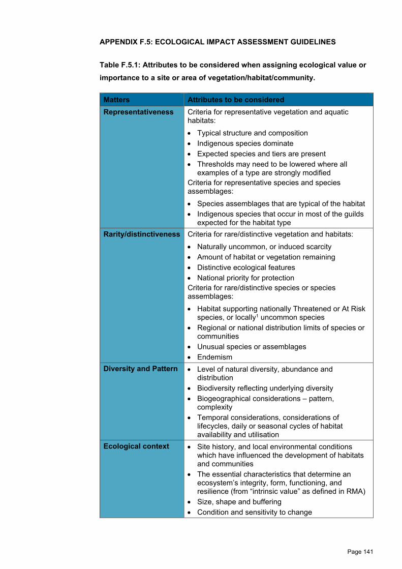
Page 141
APPENDIX F.5: ECOLOGICAL IMPACT ASSESSMENT GUIDELINES
Table F.5.1: Attributes to be considered when assigning ecological value or importance to a site or area of vegetation/habitat/community.
Matters Attributes to be considered Representativeness Criteria for representative vegetation and aquatic
habitats: • Typical structure and composition• Indigenous species dominate• Expected species and tiers are present• Thresholds may need to be lowered where all
examples of a type are strongly modifiedCriteria for representative species and species assemblages: • Species assemblages that are typical of the habitat• Indigenous species that occur in most of the guilds
expected for the habitat typeRarity/distinctiveness Criteria for rare/distinctive vegetation and habitats:
• Naturally uncommon, or induced scarcity• Amount of habitat or vegetation remaining• Distinctive ecological features• National priority for protectionCriteria for rare/distinctive species or speciesassemblages:• Habitat supporting nationally Threatened or At Risk
species, or locally1 uncommon species• Regional or national distribution limits of species or
communities• Unusual species or assemblages• Endemism
Diversity and Pattern • Level of natural diversity, abundance anddistribution
• Biodiversity reflecting underlying diversity• Biogeographical considerations – pattern,
complexity• Temporal considerations, considerations of
lifecycles, daily or seasonal cycles of habitatavailability and utilisation
Ecological context • Site history, and local environmental conditionswhich have influenced the development of habitatsand communities
• The essential characteristics that determine anecosystem’s integrity, form, functioning, andresilience (from “intrinsic value” as defined in RMA)
• Size, shape and buffering• Condition and sensitivity to change

Page 142
• Contribution of the site to ecological networks,linkages, pathways and the protection andexchange of genetic material
• Species role in ecosystem functioning – high level,key species identification, habitat as proxy
1 Locally – defined as within Ecological District.
Table F.5.2: Scoring for sites or areas combining values for four matters in Table F.5.1.
Value Description
Very high Area rates High for 3 or all of the four assessment matters listed in Table F.5.1. Likely to be nationally important and recognised as such.
High Area rates High for 2 of the assessment matters, Moderate and Low for the remainder, or Area rates High for 1 of the assessment maters, Moderate for the remainder. Likely to be regionally important and recognised as such.
Moderate Area rates High for one matter, Moderate and Low for the remainder, or Area rates Moderate for 2 or more assessment matters Low or Very Low for the remainder Likely to be important at the level of the Ecological District.
Low Area rates Low or Very Low for majority of assessment matters and Moderate for one. Limited ecological value other than as local habitat for tolerant native species.
Negligible Area rates Very Low for 3 matters and Moderate, Low or Very Low for remainder.

Page 143
Table F.5.3: Factors to consider in assigning value to terrestrial species for EcIA.
Species values Habitat values
Nationally Threatened species, found in the zone of influence (“ZOI”) either permanently or seasonally.
Very high
Species listed as At Risk – Declining, found in the ZOI, either permanently or seasonally.
High
Species listed as any other category of At Risk, found in the ZOI either permanently or seasonally.
Moderate
Locally (Ecological District) uncommon or distinctive species (e.g. kererū, tūī, bellbird).
Moderate
Nationally and locally common indigenous species. Low
Exotic species, including pests, species having recreational value.
Negligible
Table F.5.4: Criteria for describing ‘Magnitude of Effect’
Magnitude Description
Very high Total loss of, or very major alteration to, key elements/features/ of the existing baseline1 conditions, such that the post-development character, composition and/or attributes will be fundamentally changed and may be lost from the site altogether; AND/OR Loss of a very high proportion of the known population or range of the element/feature
High Major loss or major alteration to key elements/features of the existing baseline conditions such that the post-development character, composition and/or attributes will be fundamentally changed; AND/OR Loss of a high proportion of the known population or range of the element/feature
‘Moderate’ Loss or alteration to one or more key elements/features of the existing baseline conditions, such that the post-development character, composition and/or attributes will be partially changed; AND/OR Loss of a ‘Moderate’ proportion of the known population or range of the element/feature

Page 144
Magnitude Description
Low Minor shift away from existing baseline conditions. Change arising from the loss/alteration will be discernible, but underlying character, composition and/or attributes of the existing baseline condition will be similar to pre-development circumstances or patterns; AND/OR Having a minor effect on the known population or range of the element/feature
‘Negligible’ Very slight change from the existing baseline condition. Change barely distinguishable, approximating the 'no change' situation; AND/OR Having ‘Negligible’ effect on the known population or range of the element/feature
1 Baseline conditions are defined as 'the conditions that would pertain in the absence of a proposed action' (Roper-Lindsay et al., 2018).
Table F.5.5: Timescale for duration of effects
Timescale Description
Permanent Effects continuing for an undefined time beyond the span of one human generation (taken as approximately 25 years)
Long-term Where there is likely to be substantial improvement after a 25 year period (e.g. the replacement of mature trees by young trees that need > 25 years to reach maturity, or restoration of ground after removal of a development) the effect can be termed 'long term'
Temporary1 Long term (15-25 years or longer – see above) Medium term (5-15 years) Short term (up to 5 years) Construction phase (days or months)
1 Note that in the context of some planning documents, 'temporary' can have a defined timeframe.
Table F.5.6: Criteria for describing overall levels of ecological effects1.
Ecological value
Magnitude
Very high High Moderate Low ‘Negligible’
Very high Very high Very high High Moderate Low
High Very high Very high ‘Moderate Low Very low

Page 145
Moderate High High Moderate Low Very low
Low Moderate Low Low Very low Very low
Negligible Low Very low Very low Very low Very low
Positive Net gain Net gain Net gain Net gain Net gain 1 Note that for the purpose of this effects assessment, the matrix has been modified, namely any attribute assigned a ‘High’ ecological value and a ‘Low’ magnitude of effect have been assigned a ‘Moderate’ level of effect as opposed to ‘Low’ as shown in the matrix above.
Tables F.5.1 - F.5.6 reproduced from Roper-Lindsay, J., Fuller, S.A., Hooson, S.,
Sanders, M.D., and Ussher, G.T. (2018). Ecological Impact Assessment. EIANZ
guidelines for use in New Zealand: terrestrial and freshwater ecosystems. 2nd
edition.

Page 146
APPENDIX F.6: TERRESTRIAL AND WETLAND ECOLOGICAL VALUES
Table F.6.1: Nationally ‘Threatened’ or ‘At Risk’ plants known to be present in the Project footprint.
Common name Species name
Habitat Type
‘Ecological Value’ (EIANZ) Threat status Old
growth Kānuka forest
Secondary broadleaved forest and shrublands
Mānuka / kānuka
shrublands Divaricating Shrublands Wetland
Giant maidenhair
Adiantum formosum High value At Risk - Relict
Kānuka Kunzea robusta Very High value
Threatened - Nationally Vulnerable
Mānuka Leptospermum scoparium High value At Risk - Declining
Ramarama Lophomyrtus bullata Very High value
Threatened - Nationally Critical
Rohutu Lophomyrtus obcordata Very High value
Threatened - Nationally Critical
Rātā Metrosideros colensoi Very High value
Threatened - Nationally Vulnerable

Page 147
White rātā Metrosideros diffusa Very High value
Threatened - Nationally Vulnerable
Climbing rātā Metrosideros fulgens Very High value
Threatened - Nationally Vulnerable
Akatea Metrosideros perforata Very High value
Threatened - Nationally Vulnerable
Swamp maire Syzigium maire Very high value Threatened – Nationally Critical

Page 148
Table F.6.2: Native birds observed within a 200 km2 surrounding the Project footprint (source: OSNZ atlas squares, Robertson et al., 2007): Bird habitat preferences and observations within the Project footprint from multiple survey sources. Note this table has been adapted from Table 6.B.6 provided in Appendix B of the NoR Volume 3.6 Terrestrial Ecology Assessment (Boffa Miskell, 2018) with the addition of bird observations from the most recent T+T surveys undertaken in 2019 (final column).
Common name Scientific Name
Threat status (Robertson et al., 2017)
Habitat Type (dark green is primary habitat and light green indicates other
habitat used less preferentially)
Survey Obs.
Native Forest
Exotic Forest Shrubland
Farmland/ open country
Freshwater/ wetlands
Coastal/ Estuary
Previous Surveys
Boffa Miskell (2018)
T + T (2019)
Australasian bittern
Botaurus poiciloptilus
Threatened - Nationally Critical
White heron Ardea alba Threatened - Nationally Critical
Grey duck Anas superciliosa Threatened - Nationally Critical
Black-billed gull
Chroicocephalus bulleri
Threatened - Nationally Critical
Banded dotterel
Charadrius bicinctus
Threatened - Nationally Vulnerable
Caspian tern Hydroprogne caspia
Threatened - Nationally Vulnerable Y

Page 149
Common name Scientific Name
Threat status (Robertson et al., 2017)
Habitat Type (dark green is primary habitat and light green indicates other
habitat used less preferentially)
Survey Obs.
Native Forest
Exotic Forest Shrubland
Farmland/ open country
Freshwater/ wetlands
Coastal/ Estuary
Previous Surveys
Boffa Miskell (2018)
T + T (2019)
Red-billed gull
Chroicocephalus novaehollandiae scopulinus At Risk - Declining
Whitehead Mohoua albicilla At Risk - Declining Y
North Island robin Petroica longipes At Risk - Declining Y
Spotless crake Porzana tabuensis At Risk - Declining
NZ pipit Anthus novaeseelandiae At Risk - Declining Y Y Y
Rifleman Acanthisitta chloris At Risk - Declining Y
Marsh crake Porzana pusilla At Risk - Declining
NZ dabchick Poliocephalus rufopectus
At Risk - Recovering

Page 150
Common name Scientific Name
Threat status (Robertson et al., 2017)
Habitat Type (dark green is primary habitat and light green indicates other
habitat used less preferentially)
Survey Obs.
Native Forest
Exotic Forest Shrubland
Farmland/ open country
Freshwater/ wetlands
Coastal/ Estuary
Previous Surveys
Boffa Miskell (2018)
T + T (2019)
Kākā Nestor meridionalis
At Risk - Recovering
Bush falcon Falco novaeseelandiae
At Risk - Recovering Y Y
Pied shag Phalacrocorax varius
At Risk - Recovering
Long-tailed cuckoo
Eudynamys taitensis
At Risk - Naturally Uncommon Y
Black shag Phalacrocorax carbo
At Risk - Naturally Uncommon Y Y
Little black shag
Phalacrocorax sulcirostris
At Risk - Naturally Uncommon
Black-fronted dotterel
Elseyornis melanops
At Risk - Naturally uncommon Y
Royal spoonbill Platalea regia
At Risk - Naturally Uncommon Y

Page 151
Common name Scientific Name
Threat status (Robertson et al., 2017)
Habitat Type (dark green is primary habitat and light green indicates other
habitat used less preferentially)
Survey Obs.
Native Forest
Exotic Forest Shrubland
Farmland/ open country
Freshwater/ wetlands
Coastal/ Estuary
Previous Surveys
Boffa Miskell (2018)
T + T (2019)
Australian coot
Fulica atra australis
At Risk - Naturally Uncommon
Kākāriki spp. (unknown)
Cyanoramphus spp.
Not Threatened (C. auriceps)/At Risk – Relict (C. novaezelandiae) Y
Australian pied stilt
Himantopus leucocephalus Not Threatened Y Y
Little shag
Phalacrocorax melanoleucos brevirostris Not Threatened
White-faced heron
Egretta novaehollandiae Not Threatened Y Y
Black swan Cygnus atratus Not Threatened

Page 152
Common name Scientific Name
Threat status (Robertson et al., 2017)
Habitat Type (dark green is primary habitat and light green indicates other
habitat used less preferentially)
Survey Obs.
Native Forest
Exotic Forest Shrubland
Farmland/ open country
Freshwater/ wetlands
Coastal/ Estuary
Previous Surveys
Boffa Miskell (2018)
T + T (2019)
Paradise shelduck Tadorna variegata Not Threatened Y Y Y
Grey teal Anas gracilis Not Threatened Y
Australian harrier
Circus approximans Not Threatened Y Y Y
Pukeko Porphyrio melanotus Not Threatened Y Y Y
Spur-winged plover
Vanellus miles novaehollandiae Not Threatened Y Y Y
Southern black-backed gull Larus dominicanus Not Threatened Y Y Y
Morepork Ninox novaeseelandiae Not Threatened Y Y
New Zealand scaup
Aythya novaeseelandiae Not Threatened

Page 153
Common name Scientific Name
Threat status (Robertson et al., 2017)
Habitat Type (dark green is primary habitat and light green indicates other
habitat used less preferentially)
Survey Obs.
Native Forest
Exotic Forest Shrubland
Farmland/ open country
Freshwater/ wetlands
Coastal/ Estuary
Previous Surveys
Boffa Miskell (2018)
T + T (2019)
Kereru Hemiphaga novaeseelandiae Not Threatened Y Y Y
Shining cuckoo
Chrysococcyx lucidus Not Threatened Y Y
New Zealand kingfisher
Todiramphus sanctus Not Threatened Y Y Y
Welcome swallow Hirundo neoxena Not Threatened Y Y Y
Grey warbler Gerygone igata Not Threatened Y Y Y
North Island fantail
Rhipidura fuliginosa Not Threatened Y Y Y
North Island tomtit
Petroica macrocephala Not Threatened Y
Silvereye Zosterops lateralis Not Threatened Y Y Y
Bellbird Anthornis melanura Not Threatened Y Y Y

Page 154
Common name Scientific Name
Threat status (Robertson et al., 2017)
Habitat Type (dark green is primary habitat and light green indicates other
habitat used less preferentially)
Survey Obs.
Native Forest
Exotic Forest Shrubland
Farmland/ open country
Freshwater/ wetlands
Coastal/ Estuary
Previous Surveys
Boffa Miskell (2018)
T + T (2019)
Tui Prosthemadera novaeseelandiae Not Threatened Y Y Y
New Zealand shoveler Anas rhynchotis Not Threatened Y Y Y

Page 155
Table F.6.3: Native lizard species recorded within 50 km of the Project. Data sourced from the BioWeb Herpetofauna Database (administered by DOC) in December 2019.
Species and Conservation
Status Habitat preferences1
Known population in
the MGSR(within 1 km of Project
footprint)
Individuals recorded in last 20 years (all records)
Most recent record
Barking gecko2 (Naultinus punctatus) At Risk - Declining
Arboreal species generally observed amongst the foliage of trees in forest, scrub and shrublands.
Yes 28 (62) 2019
Ngahere gecko3 (Mokopirirakau “southern North Island”) At Risk - Declining
Generally arboreal (but occasionally found in crevices in banks). Most often observed amongst trunks and larger branches in forest trees, shrubs and scrub.
Yes 3 (8) 2014
Raukawa gecko4 (Woodworthia maculatus) Not Threatened
Arboreal or terrestrial. Observed beneath loose bark or in crevices in forest trees. Otherwise in rock crevices and rock piles often associated with open or scrub areas.
Yes 3 (25) 2019
Pacific gecko (Dactylocnemis pacificus) At Risk - Relict
Arboreal or terrestrial, very similar habitat preferences to Ngahere gecko described above but largely restricted to hill country forest in the southern North Island.
No 0 (4) 1965
Glossy brown skink (Oligosoma zelandicum) At Risk- Declining
Ground-dwelling. Prefers damp lowland areas that are densely vegetated. Found in forest, scrub and farmland.
No 3 (22) 2005
Ornate skink (Oligosoma ornatum) At Risk - Declining
Ground-dwelling. Occurs in forest and open habitats where there is established cover such as deep leaf litter, logs, rock piles and anthropogenic debris.
No 11 (29) 2012

Page 156
Species and Conservation
Status Habitat preferences1
Known population in
the MGSR(within 1 km of Project
footprint)
Individuals recorded in last 20 years (all records)
Most recent record
Northern grass skink (Oligosoma polychroma) Not Threatened
Ground-dwelling. Occurs in grassland, scrub, wetlands and rock piles.
No 8 (25) 2018
1Habitat preferences sourced from the Atlas of the amphibians and reptiles of New Zealand, DOC: https://www.doc.govt.nz/our-work/reptiles-and-frogs-distribution/atlas/ 2 Also known as Wellington green gecko. 3 Also known as Southern North Island forest gecko. 4Also known as common gecko or matua gecko.

Page 157
Table F.6.4: Summary of notable invertebrates that could be present in the Project footprint based on literature review.
Species Conservation Status NoR reference
Habitat preferences
Megadromus turgidceps (beetle)
Not classified – possibly locally uncommon
Technical Assessment 6B (Boffa Miskell, 2018)
Native forest with an intact understory1.
Meterana grandiosa (moth)
At Risk - Relict Dr Martin’s evidence, paragraph 7.19
Divaricating shrubs including Olearia species2.
Meterana exquisita (moth)
At Risk - Relict
Powelliphanta traversi traversi (snail)
Threatened - Nationally Endangered
Dr Martin’s evidence, paragraph 3.4
Powelliphanta snails are generally associated with forest areas with large accumulations of moist leaf litter. Also closely associated with calcium rich soils3.
Powelliphanta traversi tararuaensis (snail)
Threatened - Nationally Endangered
Powelliphanta marchanti (snail)
Threatened – Serious Decline
Wainuia urnula (snail)
Not classified – possibly locally uncommon
Dr Martin’s evidence, paragraph 3.4
Recorded in damp leaf litter and stable rock piles in intact and modified forest4.
1 Cartellieri & Gabor (2003). Seasonal dynamics and reproductive phenology of ground beetles (Coleoptera, Carabidae) in fragments of native forest in the Manawatu, North Island, New Zealand, New Zealand Journal of Zoology, 30:1, 31-42. 2 Patrick B. (2000). Lepidoptera of small-leaved divaricating Olearia in New Zealand and their conservation priority. Science for Conservation 168. Department of Conservation, Wellington, NZ. 3 M. J. Meads , K. J. Walker & G. P. Elliott (1984) Status, conservation, and management of the land snails of the genus Powelliphanta (Mollusca: Pulmonata), New Zealand Journal of Zoology, 11:3, 277-306.4 Efford, M. (1998). Distribution and status of native carnivorous land snails in the genera Wainuiaand Rhytida. Science for Conservation 101. Department of Conservation, Wellington, NZ.

Page 158
APPENDIX F.7: PHOTOGRAPHIC EXAMPLES OF KEY CHANGES IN HABITAT CLASSIFICATIONS FROM NOR ASSESSMENT
Figure F.7.1: Examples of areas previously classified as mānuka, kānuka shrublands at CH 5400 - CH 5600 that has been reclassified as kānuka forest due to the maturity of the kānuka canopy.
Figure F.7.2: An area previously classified as mānuka, kānuka shrublands at CH 5400 - CH 5600 that has been removed because native canopy is no longer present, which is likely a result of herbicide application (not undertaken as part of the Project).
Figure F.7.3: An area previously classified as mānuka, kānuka shrublands at CH 9900 - CH 10000 that has been reclassified as divaricating shrublands as the mānuka, kānuka canopy has been removed leaving divaricating shrubs underneath.

Page 159
Figure F.7.4: Examples of small areas of secondary broadleaved scrub located at CH 11400 - CH 11600 that were not mapped in the NoR that have since been mapped and included in this assessment.
Figure F.7.5: Examples of wetlands in the Project footprint which are at least partially dominated by native rushes but are subject to stock degradation. These wetlands are characterised as exotic wetlands in the NoR.