Embed Size (px)
Citation preview

TS 08A – Global Geodetic Reference Frame and CORS - 3 Arif Aditiya, J. Efendi, A. Syafii InaCORS : Infrastructure of GNSS CORS in Indonesia FIG Congress 2014 Engaging the Challenges, Enhancing the Relevance Kuala Lumpur, Malaysia, 16 – 21 June 2014
1/13
InaCORS : Infrastructure of GNSS CORS in Indonesia
Arif ADITIYA, Joni EFENDI, Arief SYAFII, Indonesia
Key words: GNSS, CORS, Indonesia, Infrastructure, Technology SUMMARY
Global Navigation Satellite System (GNSS) observations are increasingly used for a wide range of applications, and networks of Continuously Operating Reference Stations (CORS) are being rapidly installed in Indonesia by several institutions to provide high level positioning and practice needed users. One of the Indonesian government agency responsible for the management and operating of CORS is Geospatial Information Agency-BIG (former BAKOSURTANAL). BIG currently manages and operates 124 CORS, 19 of them in collaboration with GeoForschungsZentrum (GFZ) Germany in support of the Tsunami Early Warning System, 3 GNSS Stations in collaboration with TU Delft Netherland. Indonesian Continuously Operating Reference Stations (InaCORS) is GNSS network that covers the territory of Indonesia. GNSS-based technology began in 1995 with the establishment of IGS stations BAKO. In 2007 GNSS CORS infrastructure developed rapidly until today.
Infrastructure development of InaCORS is financial supported by the national budget and is managed by Geospatial Information Agency (BIG). Communication technologies used include virtual private network and radio. InaCORS divided in different groups by using virtual server for sites management in a variety of areas in Indonesia.
TS 08A – Global Geodetic Reference Frame and CORS - 3 Arif Aditiya, J. Efendi, A. Syafii InaCORS : Infrastructure of GNSS CORS in Indonesia FIG Congress 2014 Engaging the Challenges, Enhancing the Relevance Kuala Lumpur, Malaysia, 16 – 21 June 2014
2/13
InaCORS : Infrastructure of GNSS CORS in Indonesia
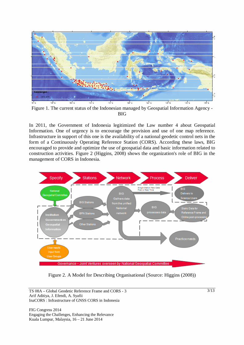
Arif ADITIYA, Joni EFENDI, Arief SYAFII, Indonesia 1. INTRODUCTION The use of technologies based on satellite for survey began in the end of 1980. At that time the use of satellite-based technology is still very limited in the surveying area of horizontal and vertical control network (Abidin et al. 2011). In 1992, Geospatial Information Agency-BIG GPS took part in the survey conducted by the International GNSS Service (IGS). Geospatial Information Agency (former National Coordinating Agency for Surveys and Mapping-BAKOSURTANAL) is the government institution that formulates the macro and national level policies governing geospatial information in Indonesia. The survey produces 60 GPS stations with zero-order classification. GPS observations on JKHN (National Horizontal Control Network) is calculated zero-order in the International Terrestrial Reference Frame 1991 (ITRF91) epoch 1992.0 (BAKOSURTANAL, 2009) The establishment of GPS Permanent Station network was initiated in 1996 and consisted of 3 continuously operating GPS reference system (CORS). There are BAKO station (West Java), SAMP station (North Sumatra) and PARE station (South Sulawesi) (Matindas and Subarya, 2009). Afterward followed the installation of other GPS stations in various areas such as Biak (2002), Kupang (2002), and Toli-toli. In March 1998 the GPS station BAKO has registered IGS (Matindas and Subarya, 2009) and the data can be international free access in Crustal Dynamics Data Information System (http://cddis.gsfc.nasa.gov). The installation rapidly grow up began in 2007 by building approximately 25 GPS stations in Sunda strains, West Java, Bali and Lombok. Then continue for add installation in 2009 of 10 GPS stations in East Nusa Tenggara and 2010 was installed 40 GPS stations in Java island. By supports from the National Budget and Hazard Mitigation Program, BIG succeeded to develop GPS permanent stations with online system up to 118 stations as illustrated in figure 1 (BIG, 2012). Until today BIG operates 124, it consists 102 stations funded from National Budget, 19 stations funded from Indonesia-German Cooperation (by means of German Indonesia Tsunami Early Warning System program), and 3 stations funded (since 1996) from Delft University of Technology (TU Delft) for operational GPS station in Palu, Watatu, and Toboli (Sulawesi island).
TS 08A – Global Geodetic Reference Frame and CORS - 3 Arif Aditiya, J. Efendi, A. Syafii InaCORS : Infrastructure of GNSS CORS in Indonesia FIG Congress 2014 Engaging the Challenges, Enhancing the Relevance Kuala Lumpur, Malaysia, 16 – 21 June 2014
3/13
Figure 1. The current status of the Indonesian managed by Geospatial Information Agency -
BIG
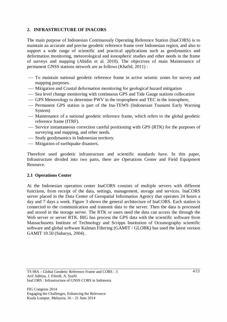
In 2011, the Government of Indonesia legitimized the Law number 4 about Geospatial Information. One of urgency is to encourage the provision and use of one map reference. Infrastructure in support of this one is the availability of a national geodetic control nets in the form of a Continuously Operating Reference Station (CORS). According these laws, BIG encouraged to provide and optimize the use of geospatial data and basic information related to construction activities. Figure 2 (Higgins, 2008) shows the organization's role of BIG in the management of CORS in Indonesia.
Figure 2. A Model for Describing Organisational (Source: Higgins (2008))
TS 08A – Global Geodetic Reference Frame and CORS - 3 Arif Aditiya, J. Efendi, A. Syafii InaCORS : Infrastructure of GNSS CORS in Indonesia FIG Congress 2014 Engaging the Challenges, Enhancing the Relevance Kuala Lumpur, Malaysia, 16 – 21 June 2014
4/13
2. INFRASTRUCTURE OF INACORS
The main purpose of Indonesian Continuously Operating Reference Station (InaCORS) is to maintain an accurate and precise geodetic reference frame over Indonesian region, and also to support a wide range of scientific and practical applications such as geodynamics and deformation monitoring, meteorological and ionospheric studies and other needs in the frame of surveys and mapping (Abidin et al. 2010). The objectives of main Maintenance of permanent GNSS stations network are as follows (Khafid, 2011) : To maintain national geodetic reference frame in active seismic zones for survey and
mapping purposes. Mitigation and Crustal deformation monitoring for geological hazard mitigation Sea level change monitoring with continuous GPS and Tide Gauge stations collocation GPS Meteorology to determine PWV in the troposphere and TEC in the ionosphere, Permanent GPS station is part of the Ina-TEWS (Indonesian Tsunami Early Warning
System) Maintenance of a national geodetic reference frame, which refers to the global geodetic
reference frame (ITRF). Service instantaneous correction careful positioning with GPS (RTK) for the purposes of
surveying and mapping, and other needs. Study geodynamics in Indonesian territory. Mitigation of earthquake disasters.
Therefore used geodetic infrastructure and scientific standards have. In this paper, Infrastructure divided into two parts, there are Operations Center and Field Equipment Resource. 2.1 Operations Center
At the Indonesian operation center InaCORS consists of multiple servers with different functions, from receipt of the data, settings, management, storage and services. InaCORS server placed in the Data Center of Geospatial Information Agency that operates 24 hours a day and 7 days a week. Figure 3 shows the general architecture of InaCORS. Each station is connected to the communication and transmit data to the server. Then the data is processed and stored in the storage server. The RTK or users need the data can access the through the Web server or server RTK. BIG has process the GPS data with the scientific software from Massachusetts Institute of Technology and Scripps Institution of Oceanography scientific software and global software Kalman Filtering (GAMIT / GLOBK) has used the latest version GAMIT 10.50 (Subarya, 2004) .

TS 08A – Global Geodetic Reference Frame and CORS - 3 Arif Aditiya, J. Efendi, A. Syafii InaCORS : Infrastructure of GNSS CORS in Indonesia FIG Congress 2014 Engaging the Challenges, Enhancing the Relevance Kuala Lumpur, Malaysia, 16 – 21 June 2014
5/13
Figure 3. General Design Architecture of Ina-CORS
Figure 4 shows the flow of access (data) starting from the station on the site until access the service (RTK / Data) by the user. From the image below shows that the InaCORS consisting of various servers. The server is not a physical server but using a virtual machine (VM). It will make easy for the management, enhancement and addition of resources in the future. Table 1 describe General Server Specification of InaCORS at Data Center.
Figure 4. Access Flow Diagram of Ina-CORS

TS 08A – Global Geodetic Reference Frame and CORS - 3 Arif Aditiya, J. Efendi, A. Syafii InaCORS : Infrastructure of GNSS CORS in Indonesia FIG Congress 2014 Engaging the Challenges, Enhancing the Relevance Kuala Lumpur, Malaysia, 16 – 21 June 2014
6/13
Server RAM Core Processor OS
Site Server 1 2 GB 2 > 2.0 GHz Win Server 2008 R2 Site Server 2 2 GB 2 > 2.0 GHz Win Server 2008 R2 Site Server 3 2 GB 2 > 2.0 GHz Win Server 2008 R2 Network server 4 GB 4 > 2.0 GHz Win Server 2008 R2 Cluster server 4 GB 4 > 2.0 GHz Win Server 2008 R2 SBC Server 2 GB 2 > 2.0 GHz Win Server 2008 R2 RTK+SBC Proxy Server 2 GB 2 > 2.0 GHz Win Server 2008 R2 Web+ QC server 4 GB 4 > 2.0 GHz Win Server 2008 R2
Table 1. General Server Specification of InaCORS
2.2 Field Resource Equipment
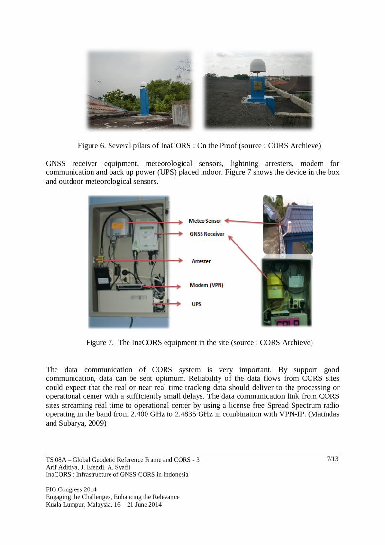
The current status of all stations of Indonesian CORS receivers system incorporates the high-precision L1/L2 geodetic type (i.e. GRX1200 family, Topcon NetG3/NetG3A, and Septentrio) with standard Choke Ring antenna and most of the GPS receivers equiped with meteorological sensors (Matindas and Subarya, 2009). In 2013 replacing several broken receivers with Leica GR10. Figure 5 and 6 shows several pillars of InaCORS on the ground and on the proof. Average height concrete pillar in the ground surface is 3.5 meters. They use identification marker contain ID site and site owner information.
Figure 5. Several pilars of InaCORS : On the Ground (source : CORS Archieve)
BAKO station
TS 08A – Global Geodetic Reference Frame and CORS - 3 Arif Aditiya, J. Efendi, A. Syafii InaCORS : Infrastructure of GNSS CORS in Indonesia FIG Congress 2014 Engaging the Challenges, Enhancing the Relevance Kuala Lumpur, Malaysia, 16 – 21 June 2014
7/13
Figure 6. Several pilars of InaCORS : On the Proof (source : CORS Archieve)
GNSS receiver equipment, meteorological sensors, lightning arresters, modem for communication and back up power (UPS) placed indoor. Figure 7 shows the device in the box and outdoor meteorological sensors.
Figure 7. The InaCORS equipment in the site (source : CORS Archieve)
The data communication of CORS system is very important. By support good communication, data can be sent optimum. Reliability of the data flows from CORS sites could expect that the real or near real time tracking data should deliver to the processing or operational center with a sufficiently small delays. The data communication link from CORS sites streaming real time to operational center by using a license free Spread Spectrum radio operating in the band from 2.400 GHz to 2.4835 GHz in combination with VPN-IP. (Matindas and Subarya, 2009)
TS 08A – Global Geodetic Reference Frame and CORS - 3 Arif Aditiya, J. Efendi, A. Syafii InaCORS : Infrastructure of GNSS CORS in Indonesia FIG Congress 2014 Engaging the Challenges, Enhancing the Relevance Kuala Lumpur, Malaysia, 16 – 21 June 2014
8/13
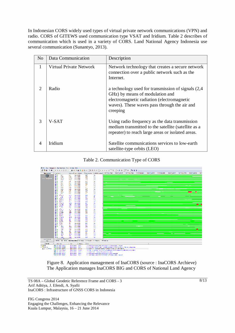
In Indonesian CORS widely used types of virtual private network communications (VPN) and radio. CORS of GITEWS used communication type VSAT and Iridium. Table 2 describes of communication which is used in a variety of CORS. Land National Agency Indonesia use several communication (Sunantyo, 2013).
No Data Communication Description
1 Virtual Private Network Network technology that creates a secure network connection over a public network such as the Internet.
2 Radio a technology used for transmission of signals (2,4 GHz) by means of modulation and electromagnetic radiation (electromagnetic waves). These waves pass through the air and creeping
3 V-SAT Using radio frequency as the data transmission medium transmitted to the satellite (satellite as a repeater) to reach large areas or isolated areas.
4 Iridium Satellite communications services to low-earth satellite-type orbits (LEO)
Table 2. Communication Type of CORS
Figure 8. Application management of InaCORS (source : InaCORS Archieve) The Application manages InaCORS BIG and CORS of National Land Agency

TS 08A – Global Geodetic Reference Frame and CORS - 3 Arif Aditiya, J. Efendi, A. Syafii InaCORS : Infrastructure of GNSS CORS in Indonesia FIG Congress 2014 Engaging the Challenges, Enhancing the Relevance Kuala Lumpur, Malaysia, 16 – 21 June 2014
9/13
3. APPLICATION OF INACORS IN INDONESIA The main purpose the utilization of the GPS data from InaCORS is for reference frame determination has been made since the 1990 (BAKOSURTANAL, 2009). CORS data usage used to determine and maintain the national reference framework with involving deformation element. Access to information related to InaCORS can be access the website inacors.big.go.id. There are available several services such as RINEX download, post processing and registration for RTK.
Figure 9. Display Web Interface of Indonesian Continuously Operating Reference Station (InaCORS)
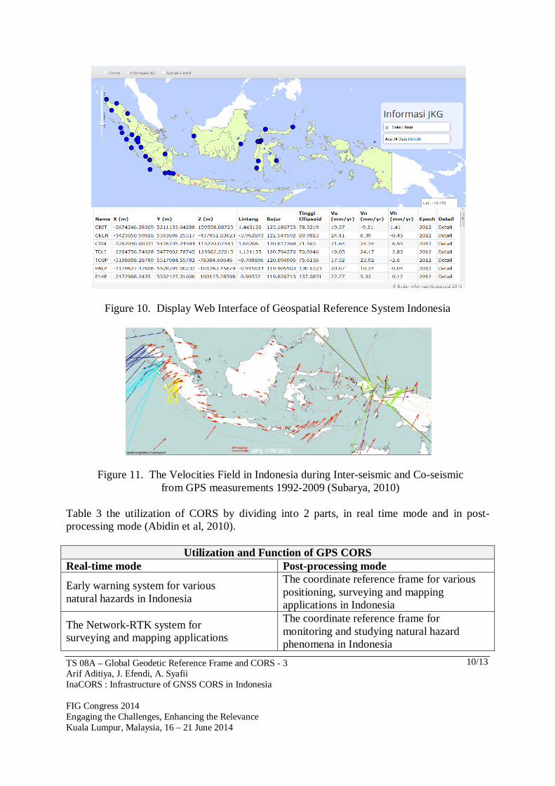
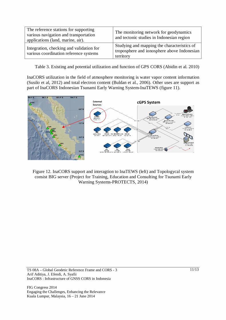
We also have information geospatial reference system and can be access through the website srgi.big.go.id (figure 10). Figure 11 shows Velocities Field in Indonesia during Inter-seismic and Co-seismic from GPS measurements 1992-2009.
TS 08A – Global Geodetic Reference Frame and CORS - 3 Arif Aditiya, J. Efendi, A. Syafii InaCORS : Infrastructure of GNSS CORS in Indonesia FIG Congress 2014 Engaging the Challenges, Enhancing the Relevance Kuala Lumpur, Malaysia, 16 – 21 June 2014
10/13
Figure 10. Display Web Interface of Geospatial Reference System Indonesia
Figure 11. The Velocities Field in Indonesia during Inter-seismic and Co-seismic from GPS measurements 1992-2009 (Subarya, 2010)
Table 3 the utilization of CORS by dividing into 2 parts, in real time mode and in post-processing mode (Abidin et al, 2010).
Utilization and Function of GPS CORS Real-time mode Post-processing mode
Early warning system for various natural hazards in Indonesia
The coordinate reference frame for various positioning, surveying and mapping applications in Indonesia
The Network-RTK system for surveying and mapping applications
The coordinate reference frame for monitoring and studying natural hazard phenomena in Indonesia
TS 08A – Global Geodetic Reference Frame and CORS - 3 Arif Aditiya, J. Efendi, A. Syafii InaCORS : Infrastructure of GNSS CORS in Indonesia FIG Congress 2014 Engaging the Challenges, Enhancing the Relevance Kuala Lumpur, Malaysia, 16 – 21 June 2014
11/13
The reference stations for supporting various navigation and transportation applications (land, marine, air).
The monitoring network for geodynamics and tectonic studies in Indonesian region
Integration, checking and validation for various coordination reference systems
Studying and mapping the characteristics of troposphere and ionosphere above Indonesian territory
Table 3. Existing and potential utilization and function of GPS CORS (Abidin et al. 2010)
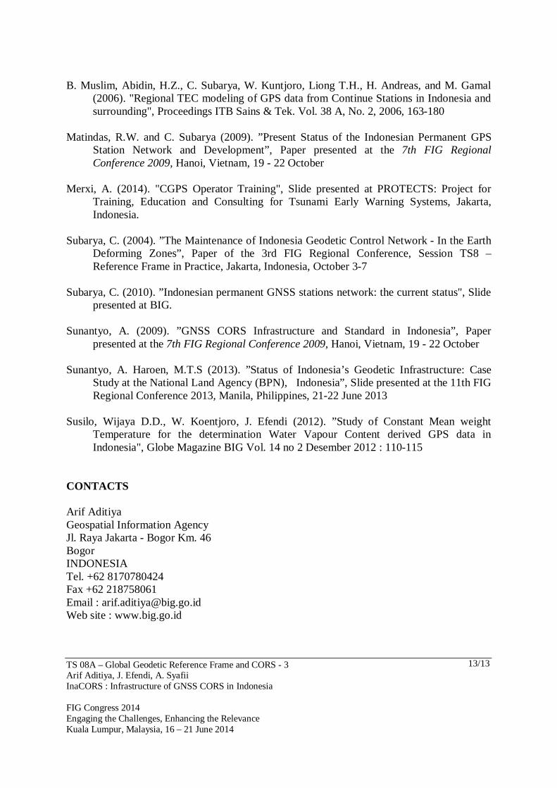
InaCORS utilization in the field of atmosphere monitoring is water vapor content information (Susilo et al, 2012) and total electron content (Buldan et al., 2006). Other uses are support as part of InaCORS Indonesian Tsunami Early Warning System-InaTEWS (figure 11).
Figure 12. InaCORS support and interagtion to InaTEWS (left) and Topologycal system consist BIG server (Project for Training, Education and Consulting for Tsunami Early
Warning Systems-PROTECTS, 2014)
TS 08A – Global Geodetic Reference Frame and CORS - 3 Arif Aditiya, J. Efendi, A. Syafii InaCORS : Infrastructure of GNSS CORS in Indonesia FIG Congress 2014 Engaging the Challenges, Enhancing the Relevance Kuala Lumpur, Malaysia, 16 – 21 June 2014
12/13
4. CLOSING REMARK Advances in positioning and navigation technology in the world, also affects the utilization of technological advances in the field of geospatial information in Indonesia, especially satellite based technology. It is characterized by the development and growth of the number of Indonesian Continuously Operating Reference Station (InaCORS) significantly. The user needs are increasingly demanding the government to be more concerned about the geospatial infrastructure of CORS. In addition to infrastructure, the quality and quantity of human resources is the main capital in management and operate InaCORS system now and in the future. Support and coordination from various stakeholders is needed, both from universities, private companies and other government agencies in all sector. It is important for the development of GPS CORS suistainable in Indonesia. Not just think as a user-oriented but also thinking how to improve the quantity and covering all aspects such as human resources, equipments, and services. REFERENCES Abidin, H.Z., C. Subarya, B. Muslim, F.H. Adiyanto, I. Meilano, H. Andreas, and I. Gumilar
(2010). “The Applications of GPS CORS in Indonesia: Status, Prospect and Limitation”, Proceedings of the FIG Congress 2010, TS 4C - GNSS CORS Networks - Infrastructure, Analysis and Applications II, Sydney, Australia, 11-16 April 2010
Abidin, H.Z., H. Andreas, I. Gumilar, F.H. Adiyanto, W. Rusmawar and Firmansyah (2011).
“On the Use of GPS CORS for Cadastral Survey in Indonesia”, Proceedings of the FIG Working Week 2011, TS03G - GNSS CORS Networks Case Studies (Flash), Marrakech, Morocco, 18-22 May 2011
BAKOSURTANAL (2009), Survey and Mapping Nusantara, Jakarta, Indonesia BIG (2012), Country Report of Geospatial Information in Indonesia, 18th Permanent
Committee on GIS Infrastructure for Asia and the Pacific Meeting, Bangkok, Thailand, 28 October - 1 November 2012
Higgins M.B., (2008), An Organisational Model for a Unified GNSS Reference
StationNetwork for Australia, Journal of Spatial Science, Vol. 53, No. 2 Khafid (2011), Indonesia Country Report of IUGG General Assembly, Melbourne, Australia,
June 28 – July 7, 2011
TS 08A – Global Geodetic Reference Frame and CORS - 3 Arif Aditiya, J. Efendi, A. Syafii InaCORS : Infrastructure of GNSS CORS in Indonesia FIG Congress 2014 Engaging the Challenges, Enhancing the Relevance Kuala Lumpur, Malaysia, 16 – 21 June 2014
13/13
B. Muslim, Abidin, H.Z., C. Subarya, W. Kuntjoro, Liong T.H., H. Andreas, and M. Gamal
(2006). "Regional TEC modeling of GPS data from Continue Stations in Indonesia and surrounding", Proceedings ITB Sains & Tek. Vol. 38 A, No. 2, 2006, 163-180
Matindas, R.W. and C. Subarya (2009). ”Present Status of the Indonesian Permanent GPS
Station Network and Development”, Paper presented at the 7th FIG Regional Conference 2009, Hanoi, Vietnam, 19 - 22 October
Merxi, A. (2014). "CGPS Operator Training", Slide presented at PROTECTS: Project for
Training, Education and Consulting for Tsunami Early Warning Systems, Jakarta, Indonesia.
Subarya, C. (2004). ”The Maintenance of Indonesia Geodetic Control Network - In the Earth
Deforming Zones”, Paper of the 3rd FIG Regional Conference, Session TS8 – Reference Frame in Practice, Jakarta, Indonesia, October 3-7
Subarya, C. (2010). ”Indonesian permanent GNSS stations network: the current status", Slide
presented at BIG. Sunantyo, A. (2009). ”GNSS CORS Infrastructure and Standard in Indonesia”, Paper
presented at the 7th FIG Regional Conference 2009, Hanoi, Vietnam, 19 - 22 October Sunantyo, A. Haroen, M.T.S (2013). ”Status of Indonesia’s Geodetic Infrastructure: Case
Study at the National Land Agency (BPN), Indonesia”, Slide presented at the 11th FIG Regional Conference 2013, Manila, Philippines, 21-22 June 2013
Susilo, Wijaya D.D., W. Koentjoro, J. Efendi (2012). ”Study of Constant Mean weight
Temperature for the determination Water Vapour Content derived GPS data in Indonesia", Globe Magazine BIG Vol. 14 no 2 Desember 2012 : 110-115
CONTACTS Arif Aditiya Geospatial Information Agency Jl. Raya Jakarta - Bogor Km. 46 Bogor INDONESIA Tel. +62 8170780424 Fax +62 218758061 Email : [email protected] Web site : www.big.go.id