Embed Size (px)
Citation preview
UNIMAS E-Journal of Civil Engineering, Vol. 3 (Special Issue) 2012
41
Abstract - This paper is promoting the awareness that nature and engineering structure can co-exist together. Natural floodplain
inundation is usually restrained to separate floodplain lands for human uses. In contrary to conventional flood control systems, a vision of
restoring floodplain inundation in Kuching Bypass Floodway is presented as a flood mitigation plan. Modelling of the approach indicates a
reduction of flooded areas up to 61%. By means of modelling, portions of floodplains are virtually preserved in their natural states and
functions, a role that often has been undervalued. Floodplain permits storage and conveyance of floodwaters. At the same time, it provides
replenishment of the adjoining wetlands. The strategy proves beneficial to both human and natural systems. It also calls for a systemic
change in flood management that we can live with the natural forces instead of forbidding them.
Keywords: Floodway, Modelling, Nature conservancy, River, Water.
I. BACKGROUND
floodplain is the area adjoining a river that is naturally covered by seasonal floodwater. A floodway is a channel and
parts of the floodplain connected to a river that is reasonably required to efficiently carry the floodwater of a river.
Conventionally, flood control systems favour compounded river and floodway, prohibiting spills over the river bank to
protect heavy human settlements in the floodplain. Even so, flood remains common to every corner of the world.
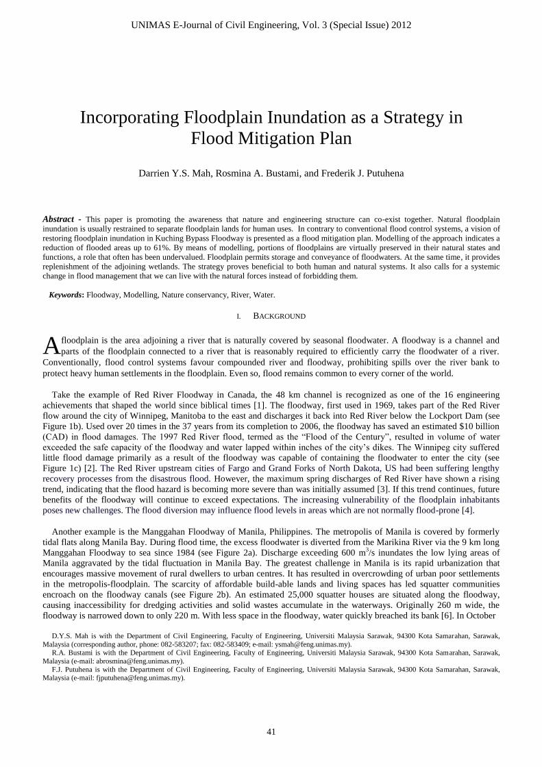
Take the example of Red River Floodway in Canada, the 48 km channel is recognized as one of the 16 engineering
achievements that shaped the world since biblical times [1]. The floodway, first used in 1969, takes part of the Red River
flow around the city of Winnipeg, Manitoba to the east and discharges it back into Red River below the Lockport Dam (see
Figure 1b). Used over 20 times in the 37 years from its completion to 2006, the floodway has saved an estimated $10 billion
(CAD) in flood damages. The 1997 Red River flood, termed as the “Flood of the Century”, resulted in volume of water
exceeded the safe capacity of the floodway and water lapped within inches of the city’s dikes. The Winnipeg city suffered
little flood damage primarily as a result of the floodway was capable of containing the floodwater to enter the city (see
Figure 1c) [2]. The Red River upstream cities of Fargo and Grand Forks of North Dakota, US had been suffering lengthy
recovery processes from the disastrous flood. However, the maximum spring discharges of Red River have shown a rising
trend, indicating that the flood hazard is becoming more severe than was initially assumed [3]. If this trend continues, future
benefits of the floodway will continue to exceed expectations. The increasing vulnerability of the floodplain inhabitants
poses new challenges. The flood diversion may influence flood levels in areas which are not normally flood-prone [4].
Another example is the Manggahan Floodway of Manila, Philippines. The metropolis of Manila is covered by formerly
tidal flats along Manila Bay. During flood time, the excess floodwater is diverted from the Marikina River via the 9 km long
Manggahan Floodway to sea since 1984 (see Figure 2a). Discharge exceeding 600 m3/s inundates the low lying areas of
Manila aggravated by the tidal fluctuation in Manila Bay. The greatest challenge in Manila is its rapid urbanization that
encourages massive movement of rural dwellers to urban centres. It has resulted in overcrowding of urban poor settlements
in the metropolis-floodplain. The scarcity of affordable build-able lands and living spaces has led squatter communities
encroach on the floodway canals (see Figure 2b). An estimated 25,000 squatter houses are situated along the floodway,
causing inaccessibility for dredging activities and solid wastes accumulate in the waterways. Originally 260 m wide, the
floodway is narrowed down to only 220 m. With less space in the floodway, water quickly breached its bank [6]. In October
D.Y.S. Mah is with the Department of Civil Engineering, Faculty of Engineering, Universiti Malaysia Sarawak, 94300 Kota Samarahan, Sarawak,
Malaysia (corresponding author, phone: 082-583207; fax: 082-583409; e-mail: [email protected]). R.A. Bustami is with the Department of Civil Engineering, Faculty of Engineering, Universiti Malaysia Sarawak, 94300 Kota Samarahan, Sarawak,
Malaysia (e-mail: [email protected]).
F.J. Putuhena is with the Department of Civil Engineering, Faculty of Engineering, Universiti Malaysia Sarawak, 94300 Kota Samarahan, Sarawak, Malaysia (e-mail: [email protected]).
Incorporating Floodplain Inundation as a Strategy in
Flood Mitigation Plan
Darrien Y.S. Mah, Rosmina A. Bustami, and Frederik J. Putuhena
A
UNIMAS E-Journal of Civil Engineering, Vol. 3 (Special Issue) 2012
42
2009, the onset of Ondoy Typhoon had the city suffered the most devastating flood the metropolis had ever seen. Many
believe the floodway would not have overflowed had there been no informal settlers.
b) Locality of Floodway c) Imagery of 1997 Flood Extent
Figure 1 Red River Floodway, Canada [5]
It is clear that standard engineering design intends to isolate the floodplain from the river channel to make space for
human activities. Manmade structures like dikes are erected to protect floodplain communities. Therefore once overflow
happens, it would cause damages and losses to many as illustrated in the examples.
II. MOTIVATION
Recent guidelines [7], however, has encouraged portion of floodplains to be reclaimed to bring back flooding during wet
seasons. This allows the natural function of the floodplain to reoccur as the communities realize that we can live with natural
forces instead of forbidding them. This paper explores a nature-sensitive approach on the Kuching bypass floodway to
incorporate floodplain inundation as part of the local flood mitigation plan. Having valuable floodplain lands for seasonal
flooding is a luxury endeavour and usually not an option for the decision makers, take the Manggahan Floodway for an
instance. In order to counter changing climates, they tend to build bigger and deeper floodway, or adding higher dikes to
existing floodway, which are costly and unsustainable in long term well-being. Alternatively, allowing natural flooding to
take place could avoid these choices.
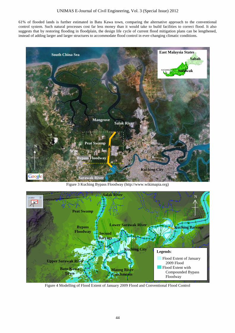
In the case of Kuching city of Malaysia, the 8 km manmade floodway would be built across a broad plain of deep peat
swamp, diverting floodwater from the Sarawak River to the Salak River (see Figure 3). The former is a freshwater system,
while the latter a coastal river lined with mangroves. The structure is expected to be in full operation by 2015. Technically,
the floodway is capable of alleviating the flooding of Kuching city centre [8]. The lowland peat swamp is found unsuitable
for agriculture and physical infrastructure development. Management of peat swamp in its natural condition and
conservation of its biodiversity is the best land use choice from a long term perspective [9]. We argue here, floodplain
inundation would be a major process to replenish the wetland ecosystems [10]. On the other hand, incorporating floodplain
inundation in the Kuching bypass floodway would cease the pressure in floodwater flushing and reduce the flooding
vulnerability in the urban floodplain along the Sarawak River.
a) Components of Floodway
Winnipeg

UNIMAS E-Journal of Civil Engineering, Vol. 3 (Special Issue) 2012
43
a) Manggahan Floodway and Metro Manila
b) Close Up on Manggahan Floodway
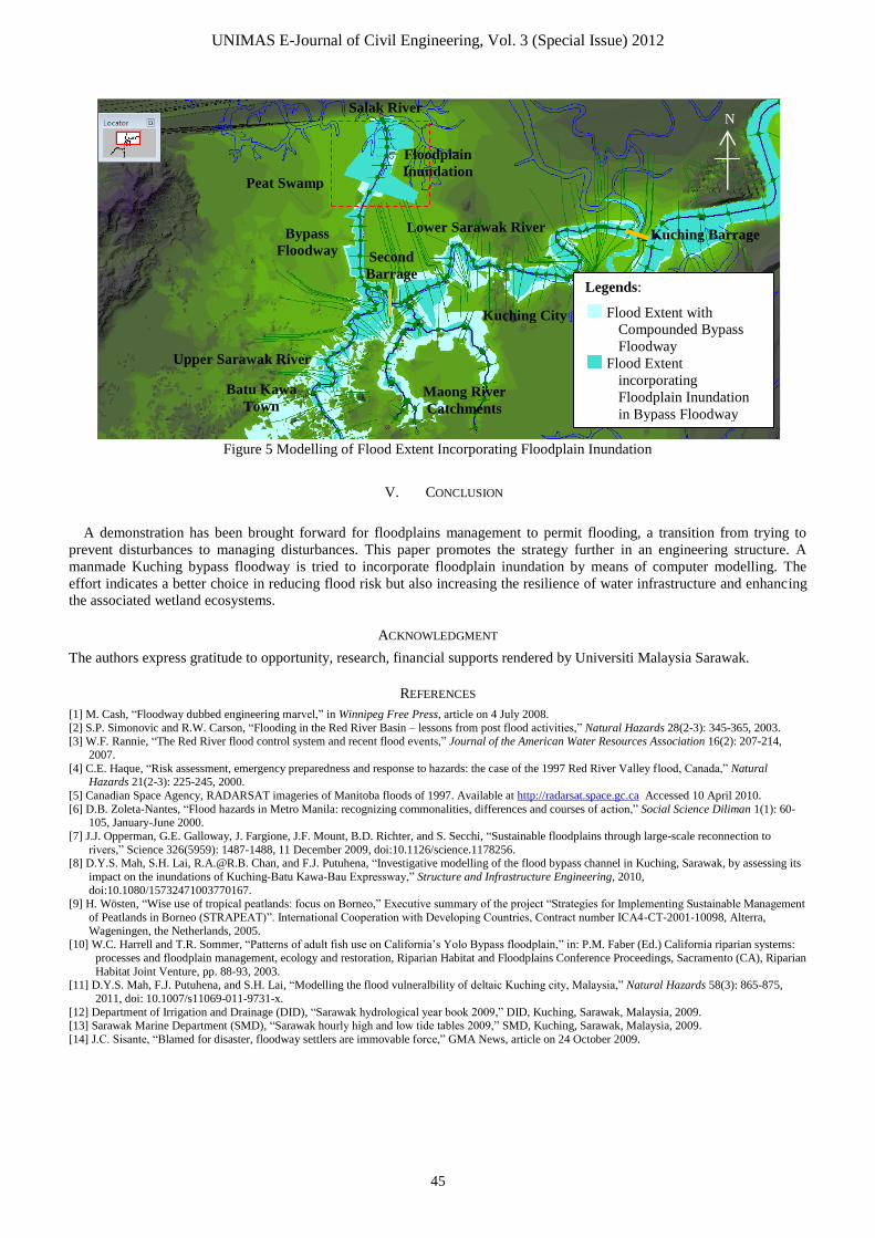
An alternative approach is depicted in Figure 5. By disallowing floodplain inundation, the floodway acts as a bottleneck
during high flow events, causing a jam of floodwaters upstream and subsequently flooding in the upstream stretches. It
should be noted that the Second Barrage would block any floodwaters flowing downstream to Kuching city in such cases.
The bunds in the downstream bypass floodway are virtually removed from the computer model to permit connection of
waterway and its floodplain. Floodplain lands and adjacent water form a dynamic physical and biological wetland system.
The connection increases the area available to store and convey floodwaters and can reduce flood risk for nearby areas. From
the technical point of view, a compounded bypass floodway has capacity limit. By allowing floodplain inundation, the
bottleneck mentioned above is lessened and thus ceases the pressure of floodwater flushing. An encouraging reduction of
Figure 2 Manggahan Floodway, the Philippines [14]
III. METHOD
A 1-D hydrodynamic model – InfoWorks River
Simulation (RS) is utilized for modelling the hydraulics
of Sarawak River systems. Examples of such modelling
are reported by Mah et al. [11]. What river modelling
means in practical terms is that software incorporates
the fundamental laws of moving water bodies along an
open channel (in this case, St. Venant Equations) into a
simulated environment where flows and water levels
change over time. Researchers then feed in time series
of river flows and water levels about the real world into
the model and see how accurately the computer-
generated results resemble what actually happens.
Hydrological monitoring stations are distributed
along the Sarawak River which provide the necessary
flow data for the upstream boundaries [12]. With that, a
base model representing the existing conditions has
been calibrated and validated to at least 80% of
confidence. The base model, carefully calibrated
against river flows for one event, can be utilised to
predict flows for the second event, and including the
flood bypass channel and associated floodplain
inundation for investigation. The bypass is modelled as
an extended river channel from the oxbow of Sarawak
River to the outlet of the bypass, excluding the Salak
River. No gauges are available at the tidally Salak
River at the moment. However, a tide table is
accessible from the marine department [13] to represent
the flows at the outlet of the bypass.
IV. RESULTS AND DISCUSSION
The most recent flood that hit the Kuching flat
happened in January 2009. This devastating 100-year
return period flood has prompted the Sarawak State
Government on the determination to construct a bypass
before the city centre. Computer modelling of the
extreme event has its flood extent drawn to a
background map in Figure 4. Consequently, a
modelling scenario of including a conventional bypass
floodway design is superimposed in the same figure for
comparison. The bypass is lined with earthen bunds on
its both sides. The computed flood extent as a result of
the control system against the repeating January 2009
flood indicates a reduction of 53% of flooded lands.
Flooding is expected to persist in Lower Sarawak River
due to high astronomical tides experienced in the
Kuching Bay. Low lying areas like Batu Kawa town in
Upper Sarawak River remain to be effected by flood
risk.
UNIMAS E-Journal of Civil Engineering, Vol. 3 (Special Issue) 2012
44
61% of flooded lands is further estimated in Batu Kawa town, comparing the alternative approach to the conventional
control system. Such natural processes cost far less money than it would take to build facilities to correct flood. It also
suggests that by restoring flooding in floodplain, the design life cycle of current flood mitigation plans can be lengthened,
instead of adding larger and larger structures to accommodate flood control in ever-changing climatic conditions.
Figure 3 Kuching Bypass Floodway (http://www.wikimapia.org)
Figure 4 Modelling of Flood Extent of January 2009 Flood and Conventional Flood Control
Kuching City
Peat Swamp
Bypass Floodway
Sarawak River
Salak River Mangrove
South China Sea
N
East Malaysia States
Sarawak
Sabah
Legends:
Flood Extent of January
2009 Flood
Flood Extent with
Compounded Bypass
Floodway
Kuching City
Lower Sarawak River
Salak River
Maong River
Catchments
Batu Kawa
Town
Bypass
Floodway
Peat Swamp
Upper Sarawak River
Kuching Barrage
N
Second
Barrage
UNIMAS E-Journal of Civil Engineering, Vol. 3 (Special Issue) 2012
45
Figure 5 Modelling of Flood Extent Incorporating Floodplain Inundation
V. CONCLUSION
A demonstration has been brought forward for floodplains management to permit flooding, a transition from trying to
prevent disturbances to managing disturbances. This paper promotes the strategy further in an engineering structure. A
manmade Kuching bypass floodway is tried to incorporate floodplain inundation by means of computer modelling. The
effort indicates a better choice in reducing flood risk but also increasing the resilience of water infrastructure and enhancing
the associated wetland ecosystems.
ACKNOWLEDGMENT
The authors express gratitude to opportunity, research, financial supports rendered by Universiti Malaysia Sarawak.
REFERENCES
[1] M. Cash, “Floodway dubbed engineering marvel,” in Winnipeg Free Press, article on 4 July 2008.
[2] S.P. Simonovic and R.W. Carson, “Flooding in the Red River Basin – lessons from post flood activities,” Natural Hazards 28(2-3): 345-365, 2003. [3] W.F. Rannie, “The Red River flood control system and recent flood events,” Journal of the American Water Resources Association 16(2): 207-214,
2007.
[4] C.E. Haque, “Risk assessment, emergency preparedness and response to hazards: the case of the 1997 Red River Valley flood, Canada,” Natural Hazards 21(2-3): 225-245, 2000.
[5] Canadian Space Agency, RADARSAT imageries of Manitoba floods of 1997. Available at http://radarsat.space.gc.ca Accessed 10 April 2010.
[6] D.B. Zoleta-Nantes, “Flood hazards in Metro Manila: recognizing commonalities, differences and courses of action,” Social Science Diliman 1(1): 60-105, January-June 2000.
[7] J.J. Opperman, G.E. Galloway, J. Fargione, J.F. Mount, B.D. Richter, and S. Secchi, “Sustainable floodplains through large-scale reconnection to
rivers,” Science 326(5959): 1487-1488, 11 December 2009, doi:10.1126/science.1178256. [8] D.Y.S. Mah, S.H. Lai, [email protected]. Chan, and F.J. Putuhena, “Investigative modelling of the flood bypass channel in Kuching, Sarawak, by assessing its
impact on the inundations of Kuching-Batu Kawa-Bau Expressway,” Structure and Infrastructure Engineering, 2010,
doi:10.1080/15732471003770167. [9] H. Wösten, “Wise use of tropical peatlands: focus on Borneo,” Executive summary of the project “Strategies for Implementing Sustainable Management
of Peatlands in Borneo (STRAPEAT)”. International Cooperation with Developing Countries, Contract number ICA4-CT-2001-10098, Alterra,
Wageningen, the Netherlands, 2005. [10] W.C. Harrell and T.R. Sommer, “Patterns of adult fish use on California’s Yolo Bypass floodplain,” in: P.M. Faber (Ed.) California riparian systems:
processes and floodplain management, ecology and restoration, Riparian Habitat and Floodplains Conference Proceedings, Sacramento (CA), Riparian
Habitat Joint Venture, pp. 88-93, 2003. [11] D.Y.S. Mah, F.J. Putuhena, and S.H. Lai, “Modelling the flood vulneralbility of deltaic Kuching city, Malaysia,” Natural Hazards 58(3): 865-875,
2011, doi: 10.1007/s11069-011-9731-x.
[12] Department of Irrigation and Drainage (DID), “Sarawak hydrological year book 2009,” DID, Kuching, Sarawak, Malaysia, 2009.
[13] Sarawak Marine Department (SMD), “Sarawak hourly high and low tide tables 2009,” SMD, Kuching, Sarawak, Malaysia, 2009.
[14] J.C. Sisante, “Blamed for disaster, floodway settlers are immovable force,” GMA News, article on 24 October 2009.
Kuching City
Lower Sarawak River
Salak River
Maong River
Catchments
Batu Kawa
Town
Bypass
Floodway
Peat Swamp
Upper Sarawak River
Kuching Barrage
N
Floodplain
Inundation
Second
Barrage Legends:
Flood Extent with
Compounded Bypass
Floodway
Flood Extent
incorporating
Floodplain Inundation
in Bypass Floodway