Embed Size (px)
Citation preview
International Journal of Scientific & Engineering Research, Volume 6, Issue 10, October-2015 19 ISSN 2229-5518
IJSER © 2015 http://www.ijser.org
The geological and geotechnical properties of earth materials of Plateau State University, Nigeria
in relation to its suitability for facility layout Ryeshak, Antipas Gabriel1, Wazoh, Hannatu Nanman2, Daku, Sunday Sani Daku2
Plataeu State Water Board Nigeria1, Department of Geology University of Jos Nigeria2
Abstract— This study aims at establishing the sub-soil types and profile to ascertain the geotechnical characteristics of the underlying soils in Plateau State University, Nigeria and recommend appropriate foundation design and construction of projects in the area. Ten (10) trial pits were dugged from where representation samples were taken and subjected to laboratory tests. They are predominantly fines (silt and clay), an indication of its great influence on the engineering properties of the soil as a whole. From the plasticity values, the soils exhibits low to medium swelling potential of 11 – 23.6. The bearing capacity of the soil at 1.5m as compared with the standard values of net bearing capacity of North central zone which is between 250-500 KN/m2 is within the recommended standard for engineering works as by calculation stands at an average of 1131. 6kN/m2. Considering the moderate compressibility of the soils, any proposed foundation in the area should be supported on raft foundations founded. However, where the project precludes the use of raft foundation pile foundation should be employed to transmit the load to the underlying soil stratum.
Index Terms— Bearing capacity, construction, earth materials, facility layout, foundation, geotechnical, soils.
—————————— ——————————
1 INTRODUCTION ppropriate civil engineering studies before any civil works not only save lives, reduce cost but control the direction of economic and social development in the
country (Bolaji, 2003)[1]. It also remove fear stigma from in-vestors and international donors, thereby enhancing people’s confidence in civil engineering sector.
Several cases of collapsed buildings and other civil engi-neering structures since pre-independence in Nigeria (Pollit,1950[2];Jegede,1989[3]) are to likely to start with one or all of the deformational failures such as cracking, subsidence, corrugation, collapsing and or sliding/formational failure etc of the sub-surface soils formations on which structures are built.
Occasionally, some of these civil engineering structures such as buildings, dams, roads etc do not stand the taste of time possibly as a result of lack of due consideration of the importance of the study of the sub-surface layers of the soils there by causing collapse. For instance, recent collapse of buildings in Lagos and even Plateau State that led to loss of lives and properties worth millions of naira is a matter of con-cern.
As a result of these, the problem of bad construction of civil works in Nigeria has become an embarrassing stigma. In many parts of the country, most of the civil works are done by unqualified personnel who are not civil engineers and even when they are, some do not give priority to any consideration of the fact that these heavy structures transmit their weight into the ground and the effect of the weight increase with time. In an attempt to minimize this, many agencies were es-tablished by the Federal Government so as to tackle the prob-lems. Prominent amongst them were the Directorate of food, Road and Rural Infrastructure (DFRRI) established in 1986. During the years of Petroleum Trust Fund (PTF), which was responsible for maintaining Federal roads and other civil con-structions works. These previous arrangements did not ade-
quately tackle the problems of structural maintenance in the country; therefore, a Presidential Policy Advisory Committee (PPAC) was set up in 1999 to look into the state of the Nation-al infrastructure. Thus, in the current democratic dispensation, the Federal Government has established Federal Road Maintenance Agency (FERMA), and other civil engineering works which is saddled with the responsibility of maintaining the application/abiding by the rules/specification of construc-tion works.
The seeming intractable problem of civil construction fail-ures points to the fact that not many of the repairs/ construc-tion works put in place during the aforementioned interven-tions was mainly addressing the collapsed building, dams and roads without getting to know the actual cause(s) of these fail-ures. It is almost never reasoned out that structural facilities, like other civil engineering structures, are founded on rocks/soils, and that civil engineering failures could be direct-ly related to the inadequate information on engineering prop-erties of those sub-grade geological materials unlike the blame is seemingly to the design and material used. This perhaps explain the reason why Nigerian civil engineers give little or no attention to the inevitable necessity of carrying out pre-construction geological/geophysical and geotechnical site investigations and even when these investigations are carried out, they could or are not factored in to the engineering design schemes before implementation. The objective of this research work cannot be overemphasized hence the need for appropri-ate geological, geophysical and geotechnical studies as a pre-requisite especially in the case of the study area (Plateau State University Bokkos) where heavy structures are to be built that will carter for thousands of people considering the future /additional load especially during various school activities. However this paper focuses only on the geologi-cal/geotechnical aspect of site investigations.
A IJSER
International Journal of Scientific & Engineering Research, Volume 6, Issue 10, October-2015 20 ISSN 2229-5518
IJSER © 2015 http://www.ijser.org
2 Background of the study area 2.1 Geographical conditions
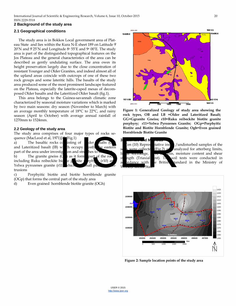
The study area is in Bokkos Local government area of Plat-eau State and lies within the Kura N-E sheet 189 on Latitude 9̊ 20’N and 9̊ 25’N and Longitude 8o 55’E and 9o 00’E. The study area is part of the distinguished topographical features on the Jos Plateau and the general characteristics of the area can be described as gently undulating surface. The area owes its height preservation largely due to the close concentration of resistant Younger and Older Granites, and indeed almost all of the upland areas coincide with outcrops of one of these two rock groups and some lateritic hills. The basalts of the study area produced some of the most prominent landscape featured on the Plateau, especially the laterite-caped mesas of decom-posed Older basalts and the Lateritized Older basalt (fig.1).
This area belongs to the Guinea-savannah climatic zone characterized by seasonal moisture variations which is marked by two main seasons: dry season (November to March) with an average monthly temperature of 18°C to 22°C, and rainy season (April to October) with average annual rainfall of 1270mm to 1524mm. 2.2 Geology of the study area The study area comprises of four major types of rocks se-quence (MacLeod et al, 1971)[4] (Fig.1) a) The basaltic rocks consisting of Older basalts (OB) and Lateritized basalt (lB) which occupy mostly the eastern part of the area under investigation and stretches to the west. b) The granite gneiss (GG) as it forms part of the rocks including Ruku reibeckite biotite granite porphyry (r10) and Yelwa pyrozenes granite (r11) which are small patches of in-trusions c) Porphyitic biotite and biotite hornblende granite (OGp) that forms the central part of the study area d) Even grained hornblende biotite granite (OGh)
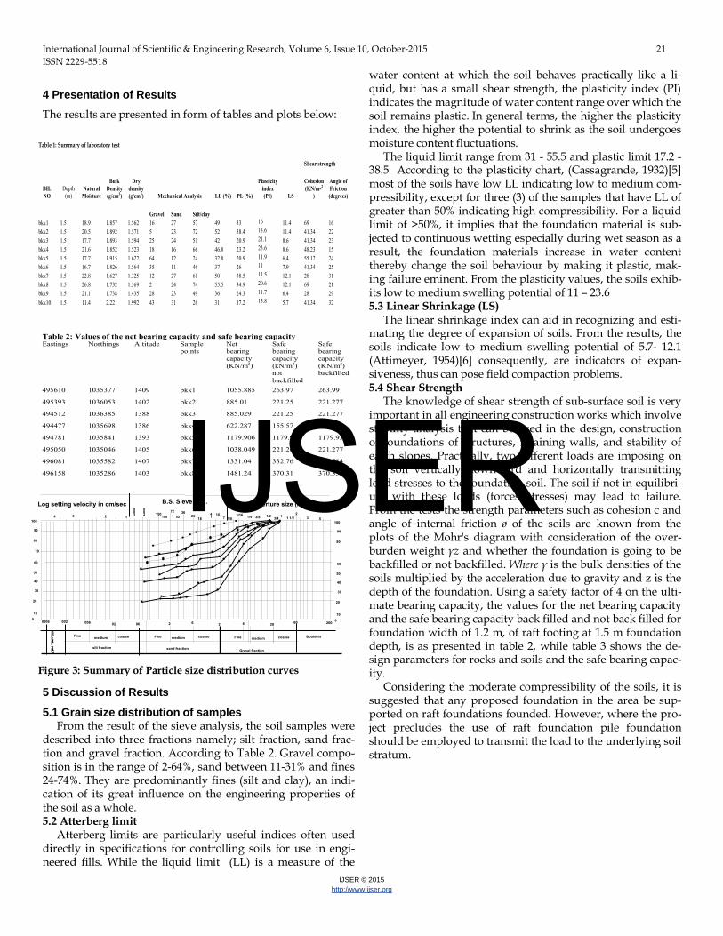
3 Materials and Methods Ten (10) Representative insitu /undisturbed samples of the
soils were collected (Fig.2) and analyzed for atterberg limits, linear shrinkage, sieve analysis, moisture content and shear strength (Triaxial test). The soil tests were conducted in accordance with the British standard in the Ministry of Works,Plateau State.
Figure 1: Generalized Geology of study area showing the rock types, OB and LB =Older and Lateritized Basalt; GG=Ggranite Gneiss; r10=Ruku reibeckite biotite granite porphyry; r11=Yelwa Pyrozenes Granite; OGp=Porphyitic Biotite and Biotite Hornblende Granite; Ogh=Even grained Hornblende Biotite Granite
494000 494500 495000 495500 496000 496500 497000
1035000
1035500
1036000
1036500
1355
1360
1365
1370
1375
1380
1385
1390
1395
1400
1405
1410
1415
1420
1425
bkk5
bkk6
bkk1
bkk7
bkk8
bkk9
bkk2
bkk3
bkk4
bkk10
494000 494500 495000 495500 496000 496500 497000
1035000
1035500
1036000
1036500
diary Dam
to Jos
to Bokkos
0 500 1000 1500 2000Km
Figure 2: Sample location points of the study area
IJSER
International Journal of Scientific & Engineering Research, Volume 6, Issue 10, October-2015 21 ISSN 2229-5518
IJSER © 2015 http://www.ijser.org
4 Presentation of Results The results are presented in form of tables and plots below:
5 Discussion of Results
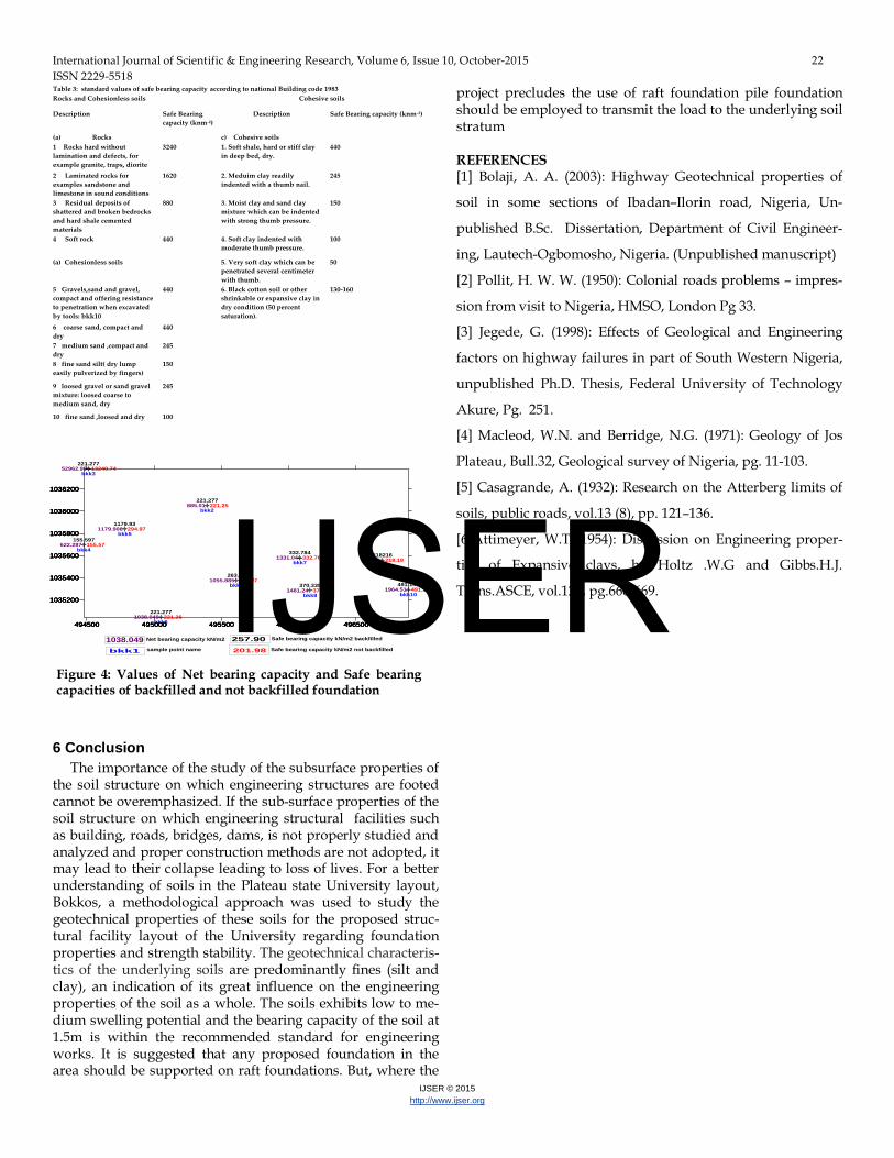
5.1 Grain size distribution of samples From the result of the sieve analysis, the soil samples were
described into three fractions namely; silt fraction, sand frac-tion and gravel fraction. According to Table 2. Gravel compo-sition is in the range of 2-64%, sand between 11-31% and fines 24-74%. They are predominantly fines (silt and clay), an indi-cation of its great influence on the engineering properties of the soil as a whole. 5.2 Atterberg limit
Atterberg limits are particularly useful indices often used directly in specifications for controlling soils for use in engi-neered fills. While the liquid limit (LL) is a measure of the
water content at which the soil behaves practically like a li-quid, but has a small shear strength, the plasticity index (PI) indicates the magnitude of water content range over which the soil remains plastic. In general terms, the higher the plasticity index, the higher the potential to shrink as the soil undergoes moisture content fluctuations.
The liquid limit range from 31 - 55.5 and plastic limit 17.2 - 38.5 According to the plasticity chart, (Cassagrande, 1932)[5] most of the soils have low LL indicating low to medium com-pressibility, except for three (3) of the samples that have LL of greater than 50% indicating high compressibility. For a liquid limit of >50%, it implies that the foundation material is sub-jected to continuous wetting especially during wet season as a result, the foundation materials increase in water content thereby change the soil behaviour by making it plastic, mak-ing failure eminent. From the plasticity values, the soils exhib-its low to medium swelling potential of 11 – 23.6 5.3 Linear Shrinkage (LS)
The linear shrinkage index can aid in recognizing and esti-mating the degree of expansion of soils. From the results, the soils indicate low to medium swelling potential of 5.7- 12.1 (Attimeyer, 1954)[6] consequently, are indicators of expan-siveness, thus can pose field compaction problems. 5.4 Shear Strength
The knowledge of shear strength of sub-surface soil is very important in all engineering construction works which involve stability analysis that can be used in the design, construction of foundations of structures, retaining walls, and stability of earth slopes. Practically, two different loads are imposing on the soil vertically downward and horizontally transmitting load stresses to the foundation soil. The soil if not in equilibri-um with these loads (forces/stresses) may lead to failure. From the tests the strength parameters such as cohesion c and angle of internal friction ø of the soils are known from the plots of the Mohr's diagram with consideration of the over-burden weight γz and whether the foundation is going to be backfilled or not backfilled. Where γ is the bulk densities of the soils multiplied by the acceleration due to gravity and z is the depth of the foundation. Using a safety factor of 4 on the ulti-mate bearing capacity, the values for the net bearing capacity and the safe bearing capacity back filled and not back filled for foundation width of 1.2 m, of raft footing at 1.5 m foundation depth, is as presented in table 2, while table 3 shows the de-sign parameters for rocks and soils and the safe bearing capac-ity.
Considering the moderate compressibility of the soils, it is suggested that any proposed foundation in the area be sup-ported on raft foundations founded. However, where the pro-ject precludes the use of raft foundation pile foundation should be employed to transmit the load to the underlying soil stratum.
Figure 3: Summary of Particle size distribution curves
IJSER
International Journal of Scientific & Engineering Research, Volume 6, Issue 10, October-2015 22 ISSN 2229-5518
IJSER © 2015 http://www.ijser.org
6 Conclusion The importance of the study of the subsurface properties of
the soil structure on which engineering structures are footed cannot be overemphasized. If the sub-surface properties of the soil structure on which engineering structural facilities such as building, roads, bridges, dams, is not properly studied and analyzed and proper construction methods are not adopted, it may lead to their collapse leading to loss of lives. For a better understanding of soils in the Plateau state University layout, Bokkos, a methodological approach was used to study the geotechnical properties of these soils for the proposed struc-tural facility layout of the University regarding foundation properties and strength stability. The geotechnical characteris-tics of the underlying soils are predominantly fines (silt and clay), an indication of its great influence on the engineering properties of the soil as a whole. The soils exhibits low to me-dium swelling potential and the bearing capacity of the soil at 1.5m is within the recommended standard for engineering works. It is suggested that any proposed foundation in the area should be supported on raft foundations. But, where the
project precludes the use of raft foundation pile foundation should be employed to transmit the load to the underlying soil stratum
REFERENCES [1] Bolaji, A. A. (2003): Highway Geotechnical properties of
soil in some sections of Ibadan–Ilorin road, Nigeria, Un-
published B.Sc. Dissertation, Department of Civil Engineer-
ing, Lautech-Ogbomosho, Nigeria. (Unpublished manuscript)
[2] Pollit, H. W. W. (1950): Colonial roads problems – impres-
sion from visit to Nigeria, HMSO, London Pg 33.
[3] Jegede, G. (1998): Effects of Geological and Engineering
factors on highway failures in part of South Western Nigeria,
unpublished Ph.D. Thesis, Federal University of Technology
Akure, Pg. 251.
[4] Macleod, W.N. and Berridge, N.G. (1971): Geology of Jos
Plateau, Bull.32, Geological survey of Nigeria, pg. 11-103.
[5] Casagrande, A. (1932): Research on the Atterberg limits of
soils, public roads, vol.13 (8), pp. 121–136.
[6]Attimeyer, W.T (1954): Discussion on Engineering proper-
ties of Expansive clays, by Holtz .W.G and Gibbs.H.J.
Trans.ASCE, vol.121, pg.666-669.
263.99
221.277
221.277
155.597
1179.93
221.277
332.784
370.335
218216
491.159
494500 495000 495500 496000 496500
1035200
1035400
1035600
1035800
1036000
1036200
bkk1
bkk2
bkk3
bkk4
bkk5
bkk6
bkk7
bkk8
bkk9
bkk10
494500 495000 495500 496000 496500
1035200
1035400
1035600
1035800
1036000
1036200
263.97
221.25
13240.74
155.57
294.97
221.26
332.76
370.31
218.19
491.126
494500 495000 495500 496000 496500
1035200
1035400
1035600
1035800
1036000
1036200
494500 495000 495500 496000 496500
1035200
1035400
1035600
1035800
1036000
1036200
1055.885
885.01
52962.98
622.287
1179.906
1038.049
1331.04
1481.24
872.77
1964.51
494500 495000 495500 496000 496500
1035200
1035400
1035600
1035800
1036000
1036200
bkk1
1038.049201.98
257.90Net bearing capacity kN/m2
sample point name
Safe bearing capacity kN/m2 backfilled
Safe bearing capacity kN/m2 not backfilled
Figure 4: Values of Net bearing capacity and Safe bearing capacities of backfilled and not backfilled foundation
IJSER