Embed Size (px)
Citation preview
Government of Rajasthan Asian Development Bank Technical Assistance Project Number: 40031
India: Rajasthan Urban Sector Development Investment Program (RUSDIP) INITIAL ENVIRONMENTAL EXAMINATION (DRAFT) JAISALMER: WATER SUPPLY SUBPROJECT SEPTEMBER 2008

1
CONTENTS
I. INTRODUCTION ...................................................................................................... 3
A. Purpose of the report ............................................................................................................................ 3
B. Extent of IEE study ............................................................................................................................... 3
II. DESCRIPTION OF THE PROJECT ......................................................................... 5
A. Type, Category and Need ..................................................................................................................... 5
B. Location, Size and Implementation Schedule ...................................................................................... 5
C. Description of the Sub-project .............................................................................................................. 6
III. DESCRIPTION OF THE ENVIRONMENT .......................................................... 12
A. Physical Resources ............................................................................................................................ 12
B. Ecological Resources ......................................................................................................................... 14
C. Economic Development ...................................................................................................................... 15
D. Social and Cultural Resources ........................................................................................................... 17
IV. ENVIRONMENTAL IMPACTS AND MITIGATION: INFRASTRUCTURE CONSTRUCTION .......................................................................................................... 19
A. Screening out areas of no significant impact ...................................................................................... 19
B. Source and supply augmentation ....................................................................................................... 20
C. Network improvement ......................................................................................................................... 22 Appendix – IV -A: REIA checklist
V. ENVIRONMENTAL IMPACTS AND MITIGATION: OPERATION AND MAINTENANCE ............................................................................................................ 32
A. Screening out areas of no significant impact ...................................................................................... 32
B. Operation and maintenance of the improved water supply system .................................................... 32
C. Environmental impacts and benefits of the operating system ............................................................ 33
VI. ENVIRONMENTAL IMPACTS AND MITIGATION: LOCATION AND DESIGN 35

2
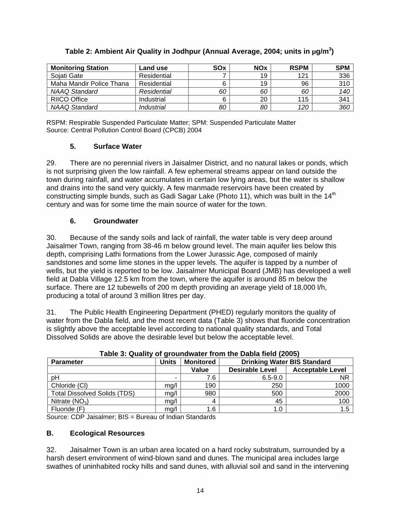
VII. INSTITUTIONAL REQUIREMENTS AND ENVIRONMENTAL MONITORING PLAN ……………………………………………………………………………………………35
A. Summary of environmental impacts and mitigation measures ........................................................... 35
B. Institutional arrangements for project implementation ........................................................................ 38
C. Environmental Monitoring Plan ........................................................................................................... 39
D. Environmental management and monitoring costs ............................................................................ 44
VIII. PUBLIC CONSULTATION AND INFORMATION DISCLOSURE ...................... 45
A. Project stakeholders ........................................................................................................................... 45
B. Consultation and disclosure to date.................................................................................................... 45
C. Future consultation and disclosure ..................................................................................................... 46
IX. FINDINGS AND RECOMMENDATIONS ............................................................ 46
A. Findings .............................................................................................................................................. 46
B. Recommendations .............................................................................................................................. 49
X. CONCLUSIONS ..................................................................................................... 49
APPENDIX 1: Summary of Consultation Meeting held in March 2007………………………..53
3
I. INTRODUCTION A. Purpose of the report 1. Rajasthan Urban Sector Development Investment Program (RUSDIP) is intended to optimize social and economic development in 15 selected towns in the State, particularly district headquarters and towns with significant tourism potential. This will be achieved through investments in urban infrastructure (water supply; sewerage and sanitation; solid waste management; urban drainage; urban transport and roads), urban community upgrading (community infrastructure; livelihood promotion) and civic infrastructure (art, culture, heritage and tourism; medical services and health; fire services; and other services). RUSDIP will also provide policy reforms to strengthen urban governance, management, and support for urban infrastructure and services. The assistance will be based on the State-level framework for urban reforms, and institutional and governance reforms recommended by the Government of India (GoI) through the Jawaharlal Nehru National Urban Renewal Mission (JNNURM) and Urban Infrastructure Development Scheme for Small and Medium Towns (UIDSSMT). 2. RUSDIP will be implemented over a five year period beginning in late 2007, and will be funded by a loan via the Multitranche Financing Facility (MFF) of the ADB. The Executing Agency (EA) is the Local Self-Government Department (LSGD) of the Government of Rajasthan (GoR); and the Implementing Agency (IA) is the Project Management Unit (PMU) of the Rajasthan Urban Infrastructure Development Project (RUIDP), which is currently in the construction stage. Alwar, Jaisalmer and Jhalawar/Jhalrapatan are the towns chosen to benefit from the first tranche of RUSDIP investment. 3. RUSDIP will improve infrastructure through the design and implementation of a series of subprojects, each providing improvements in a particular sector (water supply, sewerage, etc) in one town. RUSDIP has been classified by ADB as environmental assessment category B (some negative impacts but less significant than category A). The impacts of subprojects prepared for the first tranche of funding were assessed by 13 Initial Environmental Examination (IEE) Reports and 3 Environmental Reviews, prepared according to ADB Environment Policy (2002) and Environmental Assessment Guidelines (2003). This document is the IEE report for the Jaisalmer Water Supply Subproject. B. Extent of IEE study 4. Indian law and ADB policy require that the environmental impacts of development projects are identified and assessed as part of the planning and design process, and that action is taken to reduce those impacts to acceptable levels. This is done through the environmental assessment process, which has become an integral part of lending operations and project development and implementation worldwide. 1. ADB Policy 5. ADB’s Environment Policy requires the consideration of environmental issues in all aspects of the Bank’s operations, and the requirements for Environmental Assessment are described in Operations Manual (OM) 20: Environmental Considerations in ADB Operations. This states that ADB requires environmental assessment of all project loans, programme loans, sector loans, sector development programme loans, financial intermediation loans and private sector investment operations.

4
6. The nature of the assessment required for a project depends on the significance of its environmental impacts, which are related to the type and location of the project, the sensitivity, scale, nature and magnitude of its potential impacts, and the availability of cost-effective mitigation measures. Projects are screened for their expected environmental impacts and are assigned to one of the following categories:
Category A: Projects that could have significant environmental impacts. An Environmental Impact Assessment (EIA) is required.
Category B: Projects that could have some adverse environmental impacts, but of less
significance than those for category A. An Initial Environmental Examination (IEE) is required to determine whether significant impacts warranting an EIA are likely. If an EIA is not needed, the IEE is regarded as the final environmental assessment report.
Category C: Projects that are unlikely to have adverse environmental impacts. No EIA
or IEE is required, although environmental implications are reviewed.
Category FI: Projects that involve a credit line through a financial intermediary (FI) or an equity investment in a FI. The FI must apply an environmental management system, unless all subprojects will result in insignificant impacts.
7. The Bank has classed this program as Category B and following normal procedure for MFF loans has determined that one IEE will be conducted for each subproject, with a subproject being the infrastructure improvements in a particular sector (water supply, sewerage, etc) in one town. 2. National Law 8. The GoI EIA Notification of 2006 (replacing the EIA Notification of 1994), sets out the requirement for Environmental Assessment in India. This states that Environmental Clearance (EC) is required for specified activities/projects, and this must be obtained before any construction work or land preparation (except land acquisition) may commence. Projects are categorised as A or B depending on the scale of the project and the nature of its impacts. 9. Category A projects require EC from the national Ministry of Environment and Forests (MoEF). The proponent is required to provide preliminary details of the project in the form of a Notification, after which an Expert Appraisal Committee (EAC) of the MoEF prepares comprehensive Terms of Reference (ToR) for the EIA study, which are finalized within 60 days. On completion of the study and review of the report by the EAC, MoEF considers the recommendation of the EAC and provides the EC if appropriate. 10. Category B projects require environmental clearance from the State Environment Impact Assessment Authority (SEIAA). The State level EAC categorises the project as either B1 (requiring EIA study) or B2 (no EIA study), and prepares ToR for B1 projects within 60 days. On completion of the study and review of the report by the EAC, the SEIAA issues the EC based on the EAC recommendation. The Notification also provides that any project or activity classified as category B will be treated as category A if it is located in whole or in part within 10 km from the boundary of protected areas, notified areas or inter-state or international boundaries.

5
11. The only type of infrastructure provided by the RUSDIP that is specified in the EIA Notification is solid waste management, where EC is required for all Common Municipal Solid Waste Management Facilities (facilities that are shared by more than one town)1. EC is thus not required for the water supply sub-project that is the subject of this IEE. 3. Review and Approval Procedure 12. For Category B projects the Draft IEE report and its summary (SIEE) are reviewed by ADB’s Regional Department sector division and Environment and Social Safeguards Division, and by the Executing Agency, and additional comments may be sought from project affected people and other stakeholders. All comments are incorporated in preparing the final documents, which are reviewed by the Executing Agency and the national environmental protection agency (MoEF in this case). The EA then officially submits the IEE and SIEE reports to ADB for consideration by the Board of Directors. Completed reports are made available worldwide by ADB, via the depository library system and the ADB website. 4. Scope of Study 13. This is the IEE for the Jaisalmer Water Supply subproject. It discusses the environmental impacts and mitigation measures relating to the location, design, construction and operation of all physical works proposed under this subproject. It is one of 18 documents describing the environmental impacts and mitigation of all subprojects proposed in Tranche 1. These documents were prepared in January and February 2007 by one International and one Domestic Environmental Specialist via inputs of two and three months respectively.
II. DESCRIPTION OF THE PROJECT A. Type, Category and Need 14. This is a water supply sub-project, and as explained above it has been classified by ADB as Category B, because it is not expected to have major negative environmental impacts. Under ADB procedures such projects require an IEE to identify and mitigate the impacts, and to determine whether further study or a more detailed EIA may be required. The sub-project is needed because the present water supply infrastructure in Jaisalmer is inadequate for the needs of the growing population. The distribution system supplies 80% of the population, but water is available for only 1-2 hours per day, mainly because of system losses (estimated at 40%) and low and unequal network pressure. The provision is also unequal, with un-served areas being mainly the slums and newly-developed areas. This is one of a series of subprojects designed by the RUSDIP that are intended to raise the standards of the municipal infrastructure and services of Jaisalmer and the other urban centres to those expected of modern Asian towns. B. Location, Size and Implementation Schedule 15. The sub-project is located in Jaisalmer, the headquarters town of Jaisalmer District, in the west of Rajasthan in north-western India (Figure 1). Improvements in the distribution system will affect only certain parts of the town, such as slums and developing areas where a new network will be provided, and certain other locations where 3 overhead storage reservoirs will
1 According to the Rajasthan State Pollution Control Board, the MoEF intends to issue a clarification to the EIA Notification in due course, which will add all landfill facilities and Sewage Treatment Plants to the list of projects specified as requiring EC under the Notification. This has not yet been issued, so the text above indicates the correct legal position at the time of writing (February 2007)

6
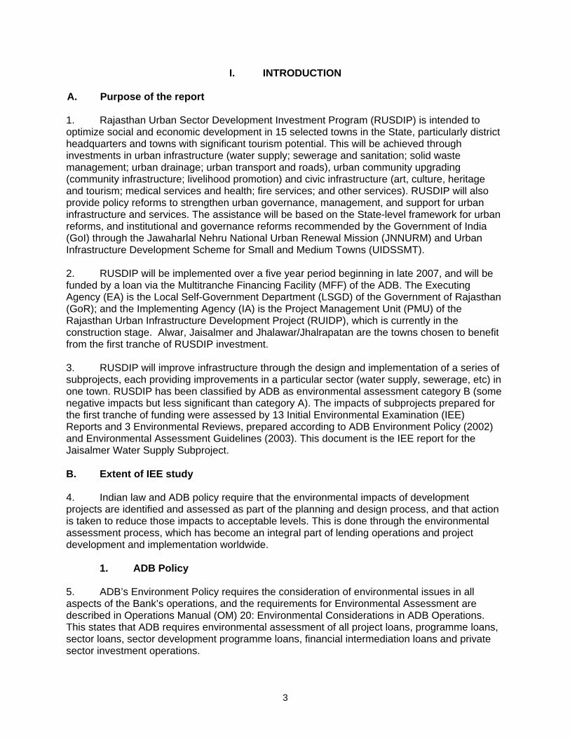
be built on small areas of government land (Figure 3). Larger-scale facilities, including a new pumping station and a 57 km transmission main will run alongside the road from Mohangarth to the existing Water Treatment Plant at Gajroop Sagar. Figure 2 shows Mohangarh model and Figure 4 shows layout of proposed pumping station. 16. Detailed design developed in the middle of 2007 and completed by the middle of year 2008, after which construction of pump house will take 12 months. The transmission main and network improvements will take up to 1½ years, so all work should be completed by the end of 2009. C. Description of the Sub-project 17. Table 1 shows the nature and size of the various components of the subproject. There are three main elements: augmentation of the water source and supply; expansion/improvement of the distribution network; and reduction of non-revenue water (NRW). The infrastructure has been designed in outline only, to determine overall feasibility and budget costs, so certain aspects (such as locations of overhead reservoirs, exact locations of distribution pipes, etc) have not yet been finalised. 18. Initially it is planned that augmentation of water supply for Jaisalmer (IG canal as source) consists construction of (i) an intake and a transfer canal from Mandhau minor canal, raw water reservoir, and transmission main. A similar project with IG canal as source is proposed for Barmer town, which also consists of construction of intake, transfer canal , and raw water reservoir. This project is implemented by PHED with GoR funds. Considering the techno-economic feasibility, the proposal is revised to draw water from the raw water reservoir to be constructed for Barmer, thus eliminating the construction of a separate intake, transfer canal and raw water reservoir for Jaisalmer. It will also eliminate laying of a separate dedicated power supply line for Jaisalmer. Only pumping station is considered under RUIDP project. 19 Thus augmentation of the water source will only involve construction of a pump house and a 58 km transmission main to transfer water to the existing Water Treatment Plant (WTP). There will also be minor rehabilitation of equipment and machinery at the WTP, principally replacement of damaged screens for the removal of debris. The transmission main will be of 700 mm diameter Ductile Iron (DI) pipe, and will stretch for 57 km alongside the main road from Mohangarth (Photo 3), where it will be buried in a trench (approximately 1.5 m deep) in the Right of Way (ROW) of the road. At points where the road bends significantly the pipeline may take a shorter route across small areas of barren land and some cultivated farmland, although most of the route is expected to be adjacent to the road. Rising main of 7.58 km considered for connecting OHSR. 20. Expansion and improvement of the distribution system will involve: the provision of piped water to slums and new areas of housing; construction of overhead storage reservoirs; and the provision of chlorination plants to improve the treatment and quality of the water supplied. 21. The network expansion will be provided from 62 km of 90-150 mm diameter MDPE/ UPVC, which will be located in trenches alongside neighbourhood streets and in unpaved lanes in slums. The storage reservoirs will be located on parcels of government-owned land at various locations in the town. All will be constructed from Reinforced Cement Concrete (RCC), and will measure approximately 15 x 10 m x 3 m deep.


11
Table 1: Improvements in water supply infrastructure proposed in Jaisalmer (as per revised scope)
Infrastructure Function Description Location 1. Source and Supply Augmentation Pumping station Improve water supply of the city Construction of new pump house –
mechanical and civil work The pumping station will be constructed on a government land at Mohangarh; a site of 29.87 ha (adjacent to RWR site) is identified for the purpose and same acquired
Transmission Main Rising main
Convey water from raw water reservoir to existing Water Treatment Plant (WTP) at Gajroop Sagar
57 km of 700 mm diameter Ductile Iron (DI) pipe Rising main of 7.58 km dia. 200-350 mm – connecting all OHSR
Buried in a trench, mainly in the Right of Way (ROW) alongside the main road to WTP site from Mohangarth PS. after collection from RWR of Barmer lift canal project from IGNP. Rising main connecting 3 reservoirs
Rehabilitation at WTP Improve water treatment Replacement of old screens and other machinery
Existing WTP at Gajroop Sagar
2. Expansion of Distribution Network Distribution mains Supply water to slums and developing areas 62 km of 90-150 mm diameter MDPE/UPVC
pipe Buried in unpaved lanes in slums and alongside neighbourhood streets
Overhead Reservoirs Provide increased water storage and a head of water required for gravity flow of water through the distribution system
Three sealed RCC tanks (ca 15 x 10 x 3 m), mounted 20 m above the ground on RCC supporting framework
On small parcels of government owned land, each < 35 m in diameter. At Jyanaryan Bagh colony (1250 KL), Babar Magra Union circle (1500 KL), Gaffar Bhatta (500 KL)
Chlorination Plants Water treatment Brick-built houses (ca 8 x 4 x 4 m) with small sump and chlorine injection cylinders
At reservoir sites
Pump replacement Improve water supply and pressure Replace 16 old and inefficient pumps At existing pump houses
3. Meters and House Connections Repair of house connections
Repair leaks and increase the amount and pressure of water reaching consumers
5000 small diameter MDPE/UPVC pipes Buried and above ground, connecting individual houses with the distribution main
Bulk flow meters Monitor water flow in the improved network 20 small meters and 2 ultrasonic flow meters located in brick-built houses
In brick houses at each OR and pumping station
Replacement of non-functional water meters
Monitor and regulate water usage by consumers and improve cost recovery
14,000 small meters Attached to the outside of houses

12
The three Overhead Reservoirs (OR) will be mounted on RCC supports approximately 20 m above the ground (Photo 4). Small brick houses (ca 8 x 4 x 4 m) will be built below or adjacent to the reservoirs, each housing a small sump and cylinders for chlorine injection for water treatment. A total of 16 new water pumps will also be provided, to replace old and inefficient units (Photo 5). 22. The NRW reduction programme will include replacement of leaking house connections and non-functioning consumer meters, and installation of bulk meters to measure flow in the network. A total of 5000 leaking house connections will be repaired or replaced with small-diameter MDPE/UPVC pipe, buried in shallow trenches leading from existing distribution mains to individual houses. Faulty consumer meters located outside houses will also be replaced (Photo 6). New bulk flow meters will be installed at each new reservoir and pumping station, comprising 20 units in total, plus two ultrasonic meters.
III. DESCRIPTION OF THE ENVIRONMENT A. Physical Resources 1. Location 23. Jaisalmer District is located in the extreme west of both Rajasthan and India, and shares western and northern borders with Pakistan. It lies between the longitudes of 69° 29’ to 72° 20’ East, and latitudes of 26° 01’ 20” to 28° 02’ North (Figure 1), is at an average altitude of 242 m above MSL, and forms the major part of the Great Indian Desert (Thar Desert). Jaisalmer Town is the district headquarters and lies roughly in the centre, 550 km west of the State capital Jaipur and 300 km northwest of Jodhpur. The municipal area covers 126.27 km2 in total, in which there is a population of only 57,537 according to the 2001 census. Most of the area consists of rocky hillsides and uninhabited areas of sand. 2. Topography, soil and geology 24. Although Jaisalmer Town is situated in the heart of the Thar Desert with its characteristic large and mobile sand dunes (Photo 9), the town and its environs present a different physiography. The town is located in an area of elevated rocky ridges extending from the Barmer District Hills in the south-west, and separated by undulating alluvial and sandy valleys. This area is around 15-20 km wide and stretches for over 60 km to the north of the town, and generally slopes from the north-west to the south-east. Soils are stony, sandy, and relatively infertile. 25. One of the most notable physical features of the town is Jaisalmer Fort (Photo 10), constructed in the 12th century, 75 m above ground level on a trikuta or triple-peaked hill. Two valleys run around the fort and meet in the south-east, and the surrounding land (on which the town subsequently developed) slopes towards the valleys, forming an overall bowl-like topography. There is little natural drainage and no permanent surface water, because of the very limited rainfall (see below). 26. According to the Vulnerability Atlas of India, most of Jaisalmer District, including Jaisalmer Town, is in an area of medium earthquake risk (Zone III). Although Rajasthan has not experienced a major earthquake in the recent past, there have been 37 events with a magnitude of 5-7 since 1720, with the most recent occurring in 2001. This measured 6.9 on the

13
Richter Scale, but because the epicentre was in neighbouring Gujarat, there was only limited damage Jaisalmer, although “Salim Singh ki Haveli” and “Hawa Pol” in the fort were affected. 3. Climate 27. The climate is typical of a desert region, being hot and arid, with large day-night temperature extremes and sporadic and erratic rainfall. Winter extends from November to March, and the coolest period occurs in January when daytime temperatures average below 20 °C and often fall to freezing at night. Temperatures begin to rise in March and peak in May-June, when daytime values sometimes reach 48 °C. Wind speeds may also increase at this time, and dust storms are common. The south-west monsoon arrives in July, causing a sudden drop in temperature, although the air remains dry as rain only falls on an average of six days per year. The long-term average rainfall is just 189 mm, and annual figures have been well below average on each of the past few years (Figure 4). The monsoon ends in mid-September and air temperatures rise, only to fall again a few weeks later with the onset of winter. Winds are generally light in winter and moderate to strong in the monsoon, and blow mainly from the north-west and south-west, and from the south and south west in the monsoon. Source: Agriculture Dept 2007
Figure 5: Average Annual Rainfall in Jaisalmer 2001-2005 4. Air Quality 28. There are no data on ambient air quality in Jaisalmer Town, which is not subject to monitoring by the Rajasthan State Pollution Control Board (RPCB) as there are no major industries. Located in the Thar Desert, particulate matter is likely to be high, particularly during summer dust storms driven by relatively strong north-west to south-west winds. Traffic is the only significant pollutant, so levels of oxides of sulphur and nitrogen are likely to be well within the National Ambient Air Quality Standards (NAAQS). This is illustrated by data from Jodhpur (Table 2), which is larger and has more industry than Jaisalmer, but is less exposed to particulate matter.
7
103.6
137.3
83.9
55.8
189
0
30
60
90
120
150
180
210
2001 2002 2003 2004 2005
Rai
nfal
l in m
m
Rainfall
Average Rainfall
14
Table 2: Ambient Air Quality in Jodhpur (Annual Average, 2004; units in µg/m3)
Monitoring Station Land use SOx NOx RSPM SPMSojati Gate Residential 7 19 121 336Maha Mandir Police Thana Residential 6 19 96 310NAAQ Standard Residential 60 60 60 140RIICO Office Industrial 6 20 115 341NAAQ Standard Industrial 80 80 120 360
RSPM: Respirable Suspended Particulate Matter; SPM: Suspended Particulate Matter Source: Central Pollution Control Board (CPCB) 2004 5. Surface Water 29. There are no perennial rivers in Jaisalmer District, and no natural lakes or ponds, which is not surprising given the low rainfall. A few ephemeral streams appear on land outside the town during rainfall, and water accumulates in certain low lying areas, but the water is shallow and drains into the sand very quickly. A few manmade reservoirs have been created by constructing simple bunds, such as Gadi Sagar Lake (Photo 11), which was built in the 14th century and was for some time the main source of water for the town. 6. Groundwater 30. Because of the sandy soils and lack of rainfall, the water table is very deep around Jaisalmer Town, ranging from 38-46 m below ground level. The main aquifer lies below this depth, comprising Lathi formations from the Lower Jurassic Age, composed of mainly sandstones and some lime stones in the upper levels. The aquifer is tapped by a number of wells, but the yield is reported to be low. Jaisalmer Municipal Board (JMB) has developed a well field at Dabla Village 12.5 km from the town, where the aquifer is around 85 m below the surface. There are 12 tubewells of 200 m depth providing an average yield of 18,000 l/h, producing a total of around 3 million litres per day. 31. The Public Health Engineering Department (PHED) regularly monitors the quality of water from the Dabla field, and the most recent data (Table 3) shows that fluoride concentration is slightly above the acceptable level according to national quality standards, and Total Dissolved Solids are above the desirable level but below the acceptable level.
Table 3: Quality of groundwater from the Dabla field (2005) Parameter Units Monitored Drinking Water BIS Standard Value Desirable Level Acceptable Level pH - 7.6 6.5-9.0 NRChloride (Cl) mg/l 190 250 1000Total Dissolved Solids (TDS) mg/l 980 500 2000Nitrate (NO3) mg/l 4 45 100Fluoride (F) mg/l 1.6 1.0 1.5
Source: CDP Jaisalmer; BIS = Bureau of Indian Standards B. Ecological Resources 32. Jaisalmer Town is an urban area located on a hard rocky substratum, surrounded by a harsh desert environment of wind-blown sand and dunes. The municipal area includes large swathes of uninhabited rocky hills and sand dunes, with alluvial soil and sand in the intervening

15
valleys, which are cultivated where there is enough rain. Natural vegetation is very limited, and consists of mainly sparse, scattered shrubs and grasses (Photo 12). The fauna of the town comprises mainly domesticated animals (camels, cows, goats, pigs and chickens), plus other species able to live close to man (urban birds, rodents and some insects). In the desert away from the inhabited area there is a more natural fauna, which includes hyaenas (Hyaena hyaena), desert fox (Vulpes pusilla), jackal (Conis aures) and chinkara gazelle (Gazella gazella pallas). 33. There are no forests in Jaisalmer District, mainly because of the climatic conditions. The nearest protected area is the Desert National Park 40 km away, which is designated as an excellent example of the Thar Desert ecosystem. This area includes a wide range of desert environments, including sand dunes, craggy rocks, salt lake bottoms, intermediate areas and fixed dunes, and the fauna is more diverse than found around Jaisalmer. It includes blackbuck, wolf, Indian fox, hare and desert cat, in addition to those species noted above. Small numbers of the great Indian Bustard are also found, which is an endangered bird species that is close to extinction. C. Economic Development 1. Land use 34. Located in the Thar Desert in the extreme north-west of India, Jaisalmer is an important urban centre for its vast desert hinterland, and is also of strategic importance because of its proximity to Pakistan. Traditionally a services and administrative town, it was not until the late 1970’s that trade and commerce began to increase, mainly through growth in the tourism sector. 35. Jaisalmer however offers little potential for further development, mainly because of the harsh and inhospitable landscape and the remoteness of the town. Only around 10 % (1,247 ha) of the total municipal area is developed, mainly because the remainder of the land is rocky and hilly and unsuitable for inhabitation, industry or infrastructure. Figure 5 shows the current land use in the developed area, from recently conducted surveys, which indicates that the major uses are for residential areas, roads/transportation and public and semi-public land. There is also a significant military presence, with a number of defence installations both inside and outside the town.
Source: Jaisalmer Urban Improvement Trust
Figure 6: Current land use in Jaisalmer (developed area)
36%
3%2%
4%6%
33%
16% Residential
Commercial
Industrial
Government
Recreation
Circulation
Public & semi-public
16
2. Industry and Agriculture 36. There is very little industrial development in Jaisalmer and the town is in fact classified as a “No Industries District” in State planning terms. Economic activities are growing steadily however, stimulated by development in the tourism sector, as increasing mobility and affluence means that people are able to visit more remote regions, to benefit from the dual attractions of beautiful scenery and a rich historical and cultural heritage. 37. Rajasthan Industrial Infrastructure Corporation (RIICO) has developed a small scale industrial area on 25 ha of land in the town, which currently houses 136 units, specialising mainly in light industry, such as manufacturing farm equipment, repairing automobiles and machinery, and furniture-making. There are also a number of stone polishing workshops, located here because of the vast amount of building material and decorative stone available from quarries in the surrounding hillsides. There are a number of small cottage industries in the town, manufacturing khadi, cotton and woollen garments and handicrafts, and this is one sector that has particularly benefited from the increase in tourism (Photo 13). There are also a number of hotels and restaurants, to serve the growing numbers of visitors. 38. Agriculture is restricted by both climate and physiography, as the limited rainfall and desert soils mean that there are very few areas that are suitable for agriculture, and yields are limited to a maximum of one crop per year. The main product is the fodder crop jowar, which is grown to feed the herds of camels, cattle, sheep and goats that are a feature of areas outside the town. Although the Indira Gandhi Nahar Project (IGNP) brings water for irrigation and domestic use into Rajasthan (including Jaisalmer District) from the Ravi and Bias rivers, this does not reach Jaisalmer Town where agriculture remains limited. 3. Infrastructure 39. PHED provides a piped municipal water supply in Jasailmer, which is sourced from the Dalba groundwater field (3 MLD) and from the Dewa Minor canal of the IGNP, 34 km away (5 MLD). The system supplies 80% of the population, but water is available for only 1-2 hours per day, mainly because of leakage losses (estimated at 40%) and low and unequal network pressure. The provision is also unequal, with un-served areas being mainly the slums and fringe or newly-developed areas. Profuse leaking from the network in the fort area is causing severe degradation of buildings and the fort walls and foundations. 40. There is a piped sewerage system only inside the fort, which serves 2% of the population. Developed in 1994, the system does not function well because of the undulating topography and blockages caused by solid waste, so leakages and overflows are very frequent. This contributes to the deterioration of the fort structures as well as detracting from the appearance of the fort (which is a major tourist attraction) and creating a public health hazard. There is no sewage treatment, and wastewater collected by the system accumulates in a low lying area near Gadisar Gate, which has become a major mosquito breeding ground. Most other households utilise pit latrines or septic tanks, and there are illegal connections through which sewage is deposited into open storm water drains. Because of the availability of large areas of vacant land, open disposal and open defecation are also prevalent. 41. There is also no proper system for storm water drainage in the town, and although this is not a major problem because of the limited rainfall, sudden storms (including one in 2006) can cause quite widespread flooding, damaging property and possessions. There are roadside

17
drains in certain areas, but these are poorly designed with inadequate gradients, and are frequently clogged with solid waste and polluted by sewage. 42. The solid waste management system is also ineffective, and refuse is mainly discarded in the streets and drains, and dumped on vacant plots of land. Jaisalmer generates an estimated 21 tons of solid waste per day and the Municipal Board (JMB) collects around 12 tons from its manual street sweeping operation (conducted inside the fort), and removes other waste from vacant plots irregularly. Collected waste is transported on open vehicles to the outskirts of the town and dumped on open ground. The Municipality has recently acquired a 76 ha plot of land with the intention of constructing a sanitary landfill, but at present waste is simply dumped on a part of this area. 43. Thermal power is the main source of energy in Rajasthan, contributing 89% of the electricity, compared to hydropower, which produces the remainder. State-level companies (Rajya Vidyut Utpadan Nigam Ltd, RVUN; and Rajya Vidyut Prasaran Nigam Ltd, RVPN) are responsible for power generation and transmission respectively, and distribution is provided by a regional company, the Jaipur Vidyut Vitran Nigyam Ltd (JVVNL). Power is supplied from the central grid by overhead cables carried on metal and concrete poles, mainly located in public areas alongside roads. The power supply is erratic and there are frequent outages in warmer months, and large fluctuations in voltage. 4. Transportation 44. The fort area and the walled old city are characterised by very narrow roads that are frequently congested with traffic and pedestrians. In contrast the remainder of the town has a relatively good road system, particularly in the outer areas, where streets are wide and not heavily used by traffic. The total road length in the town is 157 km, of which 70% are surfaced with bitumen/tar, 15% are stone paved and 15% are WBM (Water-borne Macadam). Most of the roads are maintained by JMB and around 15% by the Public Works Department (PWD), and the condition is generally poor, with many roads in need of repairs and resurfacing. This plus the absence of parking spaces and pedestrian walkways leads to slow traffic and congestion. 45. Transport in the city is mainly by personal vehicles (motorcycles and bicycles) and auto- and bicycle-rickshaws. The Rajasthan State Road Transport Corporation (RSRTC) runs public buses to neighbouring villages and towns and to larger towns farther afield, such as Jodhpur, Bikaner, Barmer and Jaipur, with which there are good road connections. Jaisalmer is also connected to Jodhpur, Jaipur and Delhi by the national railway. The nearest airport is 300 km away at Jodhpur, although there is a military air strip in Jaisalmer, which is also used for civilian purposes. D. Social and Cultural Resources 1. Demography 46. According to the national census the population of Jaisalmer was 38,735 in 1991 and 57,537 in 2001, which shows an annual increase of 4.9 % over the decade. Gross population density is very low (457 persons/km), but because so much of the municipal area is undeveloped there are locations of very high density, particularly in the fort and walled city. 47. Overall literacy is 74.9%, reported at 85.5% for males and 60.7% for females, which is considerably better than literacy in the state as a whole, which is 60.4% overall, and 75.7% for
18
males and 44.0% for females. The sex ratio is however significantly below the natural 1:1 ratio, being 764 females per 1000 males, lower than both the state and national averages (879 and 929 respectively). 48. According to the census, in 2001 only 32% of the population was in paid employment, significantly lower than both the state and national averages (42.1 and 39.1% respectively). This indicates that most of the townspeople are engaged in the informal sector, earning a living where they can, from small trading, casual labour, etc. Of those that are employed, almost all (96%) are involved in the service and industrial sectors, with the remainder being engaged in agricultural activities and household and cottage industries (around 2% each). 49. Around 75% of the people are Hindus, 20% are Muslim, and the remainder are mainly Sikhs and Janis. The majority of the inhabitants are Yadav Bhatti Rajputs, who take their name from a common ancestor named Bhatti. The main language is Marwari/Rajasthani, the principal dialect of the state. Most people speak the national language of Hindi and a few also speak English. Other languages spoken include Khariboli, Godvari and Urdu (because Rajasthan borders Pakistan). About 4% of the population are from Scheduled Tribes (ST), but these are part of the mainstream population, and around 10% of the population belong to scheduled castes (SC). 2. Health and educational facilities 50. There are good educational facilities in Jaisalmer, which serve both townspeople and inhabitants of surrounding villages and towns in the hinterland. There are 41 primary schools, 27 secondary schools and 7 higher secondary schools, plus two general degree colleges and an industrial training institute (ITI). 51. As the district headquarters town, Jaisalmer is the main centre for health facilities in the area and there is a district general hospital with 150 bed capacity, 4 dispensaries, a mother and child welfare centre and a government-run homeopathic hospital. There is also a private hospital of 25 bed capacity, and a number of private clinics. 3. History, culture and tourism 52. Founded with the construction of the fort in 1156, the Golden City of Jaisalmer originally became wealthy from trade because of its position on the camel-train routes between India and Central Asia, and the merchants and townspeople built magnificent houses and mansions, intricately carved from wood and sandstone. Variously occupied by Rajputs, Mughals and maharajas, the city rose again to prominence in the 17th century because of its links to Delhi, and this heralded another period of building, featuring many grand palaces and havelis (decorated residences). The city declined with the rise of shipping and the port of Bombay, but since partition and the conflicts with Pakistan, its strategic importance has once again become important, as well as more recently, its attraction to tourists. 53. Tourism has risen in importance in Jaisalmer over the past 20 years, and in 2005 there were 280,000 tourists, almost double the number that visited in 2001 (150,000). The most important features of the town in terms of both culture and tourism are:
• Jaisalmer Fort (Photo 10), built in 1156 by the Rajput ruler Jaisala, rises over the city and provides magnificent views over the surrounding desert. Carved from sandstone and featuring 99 bastions, hundreds of narrow streets, a palace and many beautiful

19
havelis and temples, this is the second oldest fort in Rajasthan. It is however suffering greatly from tourism pressure and damage from the leaking water system and ineffective drainage, and is on the World Monuments Watch list of100 endangered sites worldwide;
• Gadi Sagar south of the city walls was excavated in 1367 by Rawal Gadsi Singh. Once
the water supply for the city it is now a picturesque lake (Photo 11), with clusters of small temples, a museum, and flocks of visiting waterbirds, particularly during the winter months;
• Salem Singh, Patwon and Nathmal are the three most visited havelis and are excellent
examples of rich merchants’ houses from the grand architecture period of the 19th century (Photo 14);
• Temples abound both inside and outside the fort, and the most notable are the seven
interconnected yellow sandstone Jain temples dating from the 12th to 16th centuries and the Laxminath Hindu temple with its brightly decorated dome;.
IV. ENVIRONMENTAL IMPACTS AND MITIGATION: INFRASTRUCTURE CONSTRUCTION
A. Screening out areas of no significant impact 54. From the descriptions given in Section III.C it is clear that implementation of the project will affect quite long tracts of land both inside and outside the town where the transmission main and network extensions will be constructed, and also a specific locations for storage reservoir sites. 55. However it is not expected that the construction work will cause major negative impacts. This is mainly because:
• Pipelines will be mainly located on unused ground alongside existing roads and can be constructed without causing major disruption to road users and adjacent houses, shops and other businesses;
• New facilities within and outside the town (pump house, ORs, etc) will be located on government-owned land that is not occupied or used for any other purpose;
• Most pipeline construction will be conducted by small teams working on short lengths at a time so most impacts will be localised and short in duration;
• The overall construction programme will be relatively short for a project of this nature, and is expected to be completed in 1.5 years.
56. As a result there are several aspects of the environment that are not expected to be affected by the construction process and these can be screened out of the assessment at this stage as required by ADB procedure. These are shown in Table 4, with an explanation of the reasoning in each case.

20
Table 4: Fields in which construction is not expected to have significant impacts
Field Rationale Climate Short-term production of dust is the only effect on atmosphere Geology and seismology Excavation will not be large enough to affect these features Fisheries & aquatic biology No rivers or lakes will be affected by the construction work Wildlife and rare or endangered species
There is no wildlife or rare or endangered species in the town or on the government owned areas outside the town on which facilities will be built
Coastal resources Jaisalmer is not located in a coastal area Population and communities Construction will not affect population numbers, location or composition
57. These environmental factors have thus been screened out and will not be mentioned further in assessing the impacts of the construction process. B. Source and supply augmentation 1. Construction method 58. As explained above, augmentation of the water source and supply will involve construction of the following:
• A 57 km transmission main of 700 mm diameter DI between the RWR at Mohangarh (Barmer lift canal project) and the WTP for Jaisalmer;
• 7.58 km rising main for connecting reservoirs • Construction of new pump house in 29.87 ha government land • Replacement of screens and machinery at the WTP.
59. Construction of the 57 km transmission main is described in Section IV.C below, as the approach and environmental impacts are similar to those of the network improvements, and are somewhat different from those of the facilities considered here. 60. For construction of pump house excavation, civil construction, mechanical and electrical work is necessary. 61. The work at the WTP (such as replacement of screens for the removal of debris from the water) will be small in scale and conducted by hand. Replacement parts will be brought to site on a truck and offloaded and fitted by technicians. 2. Physical Resources 62. Although replacement of parts at the WTP should not have noticeable environmental effects, the remainder of this component involves some quite large-scale excavation, so physical impacts could be significant and will need to be mitigated. 63. Construction of pump house and will generate very small quantity of excess earth. There will therefore be small physical changes at the construction sites, and the quantity of waste could be used or even disposed without any physical impacts (on air quality, topography, soil quality, etc) at the point of disposal. The work will probably be conducted in the dry season, so there is also a lot of potential for the creation of dust.

21
64. Action will therefore be needed to reduce physical impacts at both the construction and disposal sites, by controlling dust and reducing the amount of material to be dumped. The Contractor should therefore be required to:
• Contact the town authorities to find beneficial uses for as much waste material as possible, in construction projects, to raise the level of land prior to construction of roads or buildings, or to fill previously excavated areas, such as brickworks;
• Prevent the generation of dust (which could affect surrounding agricultural land and crops) by removing waste material as soon as it is excavated (by loading directly onto trucks), and covering with tarpaulins to prevent dust during transportation.
65. Another physical impact that is often associated with large-scale excavation is the effect on drainage and the local water table if groundwater and surface water collect in the voids. However, this should not be a problem in this case, given the low rainfall and deep water table (>40 m) in this area, and the fact that the Contractor will almost certainly plan excavation work to avoid the monsoon season. 3. Ecological Resources 66. There are no protected areas or locations of any ecological interest at or near any of the sites affected by these works, so it is unlikely that the construction process will have any ecological impacts. The only concern would be if trees were removed unnecessarily, particularly at the intake where there are vegetated areas on either side of the main canal (Photo 15). To avoid this, the Contractor should be required to plant and maintain two new trees for every one that is removed. 4. Economic Development 67. The pump house is planned at government land so there should be no need to acquire land from private owners, which might affect the income and assets of owners and tenants. There should also be no effects on other features with economic implications (such as infrastructure, industry and commerce), as there are none of these facilities on these sites. 68. Pump house will be constructed within 29.87 ha govt. land, layout of which shown in Figure 4) in section II. 69. There could however be significant disruption of traffic, business and other activities, if trucks carrying waste material were allowed to enter Jaisalmer town or other built-up areas. The transportation of waste will be implemented by the Contractor in liaison with the town authorities, and the following additional precautions should thus be adopted to avoid these impacts:
• Planning transportation routes so that heavy vehicles do not enter Jaisalmer Town or other built-up areas and do not use narrow local roads, except near delivery sites;
• Scheduling the transportation of waste to avoid peak traffic periods.
5. Social and Cultural Resources 70. Rajasthan is an area with a rich and varied cultural heritage that includes many forts and palaces from the Rajput and Mughal periods, and large numbers of temples and other religious

22
sites, so there is a risk that any work involving ground disturbance could uncover and damage archaeological and historical remains. Given that the locations proposed for these facilities are uninhabited and show no obvious signs of having been used to any extent in the past, then it could be that there is a low risk of such impacts at these sites. Nevertheless this should be ascertained by consulting the appropriate authorities, and appropriate steps should be taken according to the nature of the risk. This should involve:
• Consulting historical and archaeological authorities at both national and state level to obtain an expert assessment of the archaeological potential of all proposed sites;
• Selecting alternative sites for any work proposed in areas of medium or high risk; • Including state and local archaeological, cultural and historical authorities and interest
groups in consultation forums as project stakeholders so that their expertise can be made available to the project;
• Developing a protocol for use by the Contractor in conducting any excavation work, to ensure that any chance finds are recognised and measures are taken to ensure they are protected and conserved. This should involve: o Having excavation observed by a person with archaeological field training; o Stopping work immediately to allow further investigation if any finds are
suspected; o Calling in the state archaeological authority if a find is suspected, and taking any
action they require to ensure its removal or protection in situ.
71. There are no modern-day social and cultural resources (such as schools and hospitals) on or near these sites, and no areas that are used for religious or other purposes, so there is no risk of other impacts on such community assets. 72. Finally, there could be some short-term socio-economic benefits from the construction work if local people are able to gain employment in the construction workforce. To ensure that such gains are directed towards communities most directly affected by this part of the scheme, the Contractor should be required to employ at least 50% of this labour force from communities within a radius of say 2 km from each site, if sufficient people are available. C. Network improvement 1. Construction method 73. Expansion of the distribution network will involve construction of:
• 62 km of distribution mains in slums and newly developed areas • 3 overhead reservoirs • Chlorination plants located beneath or alongside the storage reservoirs.
74. Reduction of non-revenue water will involve:
• Repair and replacement of 5,000 leaking house connections; • Replacement of 14,000 non-functional consumer meters; • Installation of bulk flow meters at each storage reservoir and pump station; • Replacement of old pumps at existing pump stations.

23
75. These all involve the same kinds of construction and will produce similar effects on the environment, so their impacts are considered together. As explained above, the impacts of the 57 km transmission main are also considered here, for the same reasons. 76. The transmission and distribution mains will be buried in trenches adjacent to roads, in the un-used area within the ROW, at the edge of the tarmac. The transmission main will run alongside the main Mohangarth road, where there is more than enough space for the pipeline. However the distribution mains will be located in roads and streets in the town, where in some places this area is occupied by drains or the edges of shops and houses etc (Photo 16), so to avoid damage to property some trenches may be dug into the edge of the road. 77. Excavated soil will be placed alongside, and the pipes (brought to site on trucks and stored on unused land nearby) will be placed in the trench by hand or using a small rig for the larger DI pipes (Photos 18 and 19). Pipes will be joined by hand, after which sand from local quarries will be shovelled into the trench beneath and around the pipe for support and protection. Soil will then be replaced manually on top of the pipe and compacted by a vibrating compressor. Where trenches are dug into an existing roadway, the bitumen or concrete surface will be broken by hand-held pneumatic drills (Photo 20), after which the trench will be excavated by backhoe, and the appropriate surface will be reapplied on completion. 78. Pipes are normally covered by 1.2 m of soil, and a clearance of 100 mm is left between the pipe and each side of the trench to allow backfilling. Trenches will therefore be quite large for the transmission main (2 m deep and 0.9 m wide) and smaller for the distribution main (minimum of 1.4 m deep and 0.3 m wide). 79. New pipes and connections to the distribution main will be provided to repair faulty house connections, and these will run to individual dwellings in small hand-dug trenches, or on the surface (Photo 21). New or replacement consumer meters will be located outside houses, attached to a wall or set onto the ground. In slum areas water will be provided via communal taps (Photo 22) from where people will collect their water. 80. The reservoirs will be built on small plots of government land (< 30 m radius) at various locations in the town. The foundations for the overhead reservoirs (OR) will be excavated by backhoe, with soil being loaded onto trucks for disposal. Aggregate and concrete will be tipped into each void to create the foundations and floor, after which metal reinforcing rods will be added to create the vertical supporting pillars of the OR. Sections of reinforcing will then be encased in wooden shuttering and concrete will be poured in, and this process will be repeated to gradually create each structure from RCC, including the tank of the OR. Surfaces will be smoothed and finished where necessary by hand. 81. Small brick rooms will be built alongside each ORs to house the chlorination plants. In each case foundations will be dug and aggregate and concrete poured in to create the floors, after which the brick walls and roof materials will be added by hand. Chlorine cylinders and other equipment (including flow-meters) will be brought in on trucks and offloaded and attached by hand. A small cavity for the chlorination sump and trenches for pipe-work will also be dug, and the sump will constructed from concrete and brick. 2. Physical Resources
24
82. This work is similar to the source augmentation component in that construction will involve quite extensive excavation, although in this case it will be spread over various locations, many of which are in the town, so the nature and significance of the impacts could be different. 83. If average trench dimensions are 2 x 0.9 m for the 65 km transmission and rising main and 1.5 x 0.4 m for the 62 km distribution main, then trench construction will excavate around 154,200 m3 of material. After construction, approximately 25% of the trench will be occupied by the pipe, 50% by backfilled sand, and 25% by excavated soil replaced on top of the pipe. This means that around 77,100 m3 of sand will be brought to site, 38,550 m3 of soil will be retained for replacement in the trench, and 115,650 m3 of waste material will be left over. Additional smaller quantities of waste will be produced by the other excavation work, that materials adds a further 20% (23,130 m3) to the total waste produced by this subproject, and in this case the impact of dust will be more significant because much of the work will be conducted in inhabited areas. It will thus be very important to limit physical impacts by finding beneficial uses for waste material as recommended above, and to apply additional precautions to limit the production and spread of dust. The Contractor should therefore be required to:
• Contact the town authorities to find beneficial uses for waste material, in construction projects, to raise the level of land prior to construction of roads or buildings, or to fill previously excavated areas, such as brickworks;
• Prevent the generation of dust by removing waste soil as soon as it is excavated; • Plan the work carefully so that sand is only brought to site when it is needed; • Cover or damp down sand and soil retained on site to reduce dust in windy weather; • Use tarpaulins to cover loose material during transportation to and from the site.
84. The other important physical impact associated with large-scale excavation (effects on surface and groundwater drainage) should again be negated by the low rainfall and very low water table in this area, and the fact that the Contractor will almost certainly conduct the excavation work in the dry season. 85. Physical impacts will also be reduced by the method of working, whereby the network will probably be constructed by small teams working on short lengths at a time, so that impacts will be mainly localised and short in duration. Physical impacts are also mainly temporary as trenches will be refilled and compacted after pipes are installed, and any disturbed road surfaces will be repaired. Because of these factors and the mitigation measures proposed above, impacts on the physical environment are not expected to be of major significance. 3. Ecological Resources 86. There are no significant ecological resources in the town (protected areas or rare or important species or habitats), so the network improvements should have no ecological impacts. Roadside trees should not be removed unnecessarily to build the trenches, and to mitigate any such losses the Contractor should be required to plant and maintain two new trees (of the same species) for each one that is removed. 4. Economic Development 87. Most of this work will be conducted on government owned land in the ROW of roads, where there is no need to acquire land from private owners. It may be necessary however to acquire small amounts of land in places along the transmission main route to avoid bends in the
25
road and allow the pipeline to follow a more direct path. If this is the case, the government will purchase land through the mechanism of the Land Acquisition Act (1894), where prices are established on the basis of recent transactions. ADB policy on Involuntary Resettlement requires that the owners and users of acquired land do not suffer economically as a result of the project, and a separate Resettlement Plan and Resettlement Framework have been prepared to examine these and related issues. This establishes that no more than 10% of the land of any owner or occupant should be acquired, and that in addition to the price of the land, farmers should be compensated for any standing crops or trees they lose. 88. Although most of the work will not require land acquisition it could still have economic impacts, if the presence of trenches, excavated material, workers and machinery discourage customers from visiting shops and businesses, which lose income as a result. These losses should be short in duration as most of the pipeline work should last for only a few days at any one site. Nevertheless the loss of income could still be significant for small traders and other businesses that exist on low profit margins. These impacts should therefore be mitigated by:
• Compensating shopkeepers and other affected businesses for lost income; • Leaving spaces for access between mounds of excavated soil, and providing
footbridges so that pedestrians can cross open trenches; • Increasing the workforce in these areas to ensure that work is completed quickly; • Consulting affected businesspeople and informing them in advance when work will
occur. 89. Excavation work could damage existing infrastructure located alongside roads, such as storm drains where present, and the sewer network inside the fort area. It will be particularly important to avoid damaging existing water pipes as these are mainly manufactured from Asbestos Cement (AC), which can be carcinogenic if inhaled, so there are serious health risks for both workers and citizens (see below). It will be important therefore to avoid these impacts by:
• Obtaining details from the Municipal Board of the nature and location of all infrastructure, and planning pipeline routes (in and outside the town) to avoid any conflict;
• Integrating construction of the various Jaisalmer subprojects (in particular water supply and sewerage) so that: o Different infrastructure is located on opposite sides of the road where feasible; o Roads and inhabitants are not subject to repeated disturbance by trenching in
the same area at different times for different purposes. 90. Transport is another type of infrastructure that will be affected by some of the work, particularly construction of pipelines in the narrower streets where there is not enough space for excavated soil to be piled off the road. The road itself may also be excavated in places where there is no available land to locate pipelines alongside. Traffic will therefore be disrupted, and in some very narrow streets the whole road may need to be closed for short periods. The Contractor should therefore plan this work in conjunction with the town authorities and the police force, so that work can be carried out during periods when traffic is known to be lighter, and alternative routes and diversions can be provided where necessary. The Contractor should also increase the workforce in areas such as this, so that the work is completed in the shortest possible time.
26
91. It is inevitable that there will be an increase in the number of heavy vehicles in the town (particularly trucks removing waste material for disposal), and this could disrupt traffic and other activities, as well as damage fragile buildings if vibration is excessive. These impacts will therefore need to be mitigated by:
• Careful planning of transportation routes with the municipal authorities to avoid sensitive areas as far as possible, including narrow streets, congested roads, important or fragile buildings and key sites of religious, cultural or tourism importance;
• Scheduling the transportation of waste to avoid peak traffic periods, the main tourism season, and other important times.
5. Social and Cultural Resources 92. As was the case for the source and supply augmentation works, there is a significant risk that the network improvements, which involve further extensive disturbance of the ground surface, could damage undiscovered remains, or even unknown sites. The risks are in fact very much higher in this case, as most of the work will be conducted in Jaisalmer town, which has been inhabited for a long period, and where there is therefore a greater risk of artefacts being discovered. The preventative measures described in Section IV.B.5 will thus need to be employed and strictly enforced. These are:
• Consulting national and state historical and archaeological authorities to assess the archaeological potential of all construction sites;
• Selecting alternative routes or sites to avoid any areas of medium or high risk; • Including state and local archaeological, cultural and historical authorities and interest
groups as project stakeholders to benefit from their expertise; • Developing a protocol for use in conducting all excavation, to recognise, protect and
conserve any chance finds (see Section IV.B.5 for details). 93. The network improvements will also disturb some more modern-day social and cultural resources, such as schools, hospitals, temples, and also sites that are of tourism importance (particularly inside the fort and walled city). Impacts could include noise, dust, interrupted access for pedestrians and vehicles, and if pneumatic drills are used to break the surface of roads, there could be a risk of damage from vibration. Given the historical importance of Jasailmer and particularly the fort and the walled city, any such damage or disruption could be highly significant, so very careful mitigation will be needed to protect these resources and to enable usage by local people and visitors to continue throughout the construction work. This will be achieved through several of the measures recommended above, including:
• Consulting the town authorities to identify any buildings at risk from vibration damage and avoiding any use of pneumatic drills or heavy vehicles in the vicinity;
• Limiting dust by removing waste soil quickly, bringing sand to site only when necessary, covering and watering stockpiles, and covering soil and sand when carried on trucks;
• Increasing the workforce in sensitive areas to complete the work quickly; • Providing wooden bridges for pedestrians and metal sheets for vehicles to allow
access across open trenches where required (including access to houses); • Using modern vehicles and machinery with standard adaptations to reduce noise and
exhaust emissions, and ensuring they are maintained to manufacturers’ specifications.

27
In addition the Executing Agency and Contractor should:
• Consult municipal authorities, custodians of important buildings, cultural and tourism authorities, and affected communities in advance of the work to identify and address key issues, and avoid working at sensitive times, such as religious and cultural festivals.
94. A different but no less significant impact is the effect on people and communities if water supplies are closed down for extended periods when work is conducted on the network. This would be inconvenient in the short term, and there could be health risks if the water supply was unavailable for several successive days or longer. It will therefore be important to take the necessary measures to avoid such a situation. This will require:
• Detailed planning of the construction program to keep the cessation of water supplies to the minimum possible (in both area and duration);
• Provision of alternative potable water to affected households and businesses for the duration of the shut-down;
• Liaison with affected persons to inform them of any cessation in advance, and to ensure that they are provided with an alternative supply.
95. There is invariably a safety risk when substantial construction such as this is conducted in an urban area, and precautions will thus be needed to ensure the safety of both workers and citizens. The Contractor will be required to produce and implement a site Health and Safety Plan, and this should include such measures as:
• Excluding the public from the site; • Ensuring that all workers are provided with and use appropriate Personal Protective
Equipment; • Health and Safety Training for all site personnel; • Documented procedures to be followed for all site activities; • Accident reports and records; • Etc.
96. An additional, particularly acute health risk presented by this work derives from the fact that, as mentioned above, the existing water supply system comprises mainly AC pipes, so there is a risk of contact with carcinogenic material if these pipes are uncovered in the course of the work. Precautions have already been introduced into the design of the project to avoid this, of which the most important are that:
• No work is proposed on those parts of the existing system that contains AC pipes (ring, carrier and distribution mains), and these will be left in situ undisturbed, so there will be no deliberate excavation of AC pipes;
• The locations of the new network will be planned to avoid all locations of existing AC pipes so AC pipes should also not be discovered accidentally.
97. Given the dangerous nature of this material for both workers and citizens, one additional measure should be taken to protect the health of all parties in the event (however unlikely) that AC pipes are encountered. This is that, during design of the water supply system, the design consultant should develop a protocol to be applied in any instance that AC pipes are found, to ensure that appropriate action is taken. This should be based on the approach recommended

28
by the United States Environmental Protection Agency (USEPA)2, and amongst other things, should involve:
• Training of all personnel (including manual labourers) to enable them to understand the dangers of AC pipes and to be able to recognise them in situ;
• Reporting procedures to inform management immediately if AC pipes are encountered; • Development and application of a detailed H&S procedure to protect both workers and
citizens. This should comply with national and international standards for dealing with asbestos, and should include: o Removal of all persons to a safe distance; o Usage of appropriate breathing apparatus and protective equipment by persons
delegated to deal with the AC material; o Procedures for the safe removal and long-term disposal of all asbestos-
containing material encountered. 98. There could again be some short-term socio-economic benefits from the construction work if local people gain employment in the workforce. To ensure that these benefits are directed to communities that are affected by the work, as suggested in Section IV.B.5, the Contractor should be required to employ at least 50% of his labour force from communities in the vicinity of construction sites. Creating a workforce from mainly local people will bring additional benefits by avoiding problems that can occur if workers are imported, including social difficulties in the host community and issues of health and sanitation in poorly serviced temporary camps. 2 In the USA, standards and approaches for handling asbestos are prescribed by the Occupational Health and Safety Administration (OHSA) and the Environmental Protection Agency (EPA) and can be found at http://www.osha.gov/SLTC/asbestos
29
APPENDIX IV-A
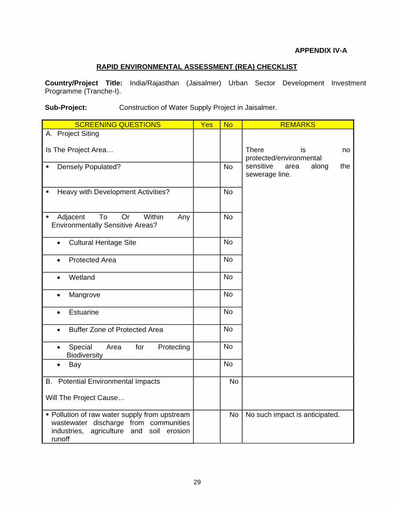
RAPID ENVIRONMENTAL ASSESSMENT (REA) CHECKLIST Country/Project Title: India/Rajasthan (Jaisalmer) Urban Sector Development Investment Programme (Tranche-I). Sub-Project: Construction of Water Supply Project in Jaisalmer.
SCREENING QUESTIONS Yes No REMARKS A. Project Siting Is The Project Area…
There is no protected/environmental sensitive area along the sewerage line.
Densely Populated?
No
Heavy with Development Activities?
No
Adjacent To Or Within Any Environmentally Sensitive Areas?
No
• Cultural Heritage Site
No
• Protected Area
No
• Wetland
No
• Mangrove
No
• Estuarine
No
• Buffer Zone of Protected Area
No
• Special Area for Protecting Biodiversity
No
• Bay
No
B. Potential Environmental Impacts Will The Project Cause…
No
Pollution of raw water supply from upstream wastewater discharge from communities industries, agriculture and soil erosion runoff
No No such impact is anticipated.

30
SCREENING QUESTIONS Yes No REMARKS Impairment of historical/cultural/monuments/areas and loss/damage to these sites.
No There is no historical/cultural/monuments/ area falls within the project area.
Hazards of land subsidence caused by excessive ground water pumping.
No Indra Ghandi Canal is the source of water for this project and location of intake point is Mohangarh in Jaisalmer.
Social conflicts arising from displacement of communities.
No No need of R& R for this project.
Conflicts in abstraction of raw water for water supply with other beneficial water uses for surface and ground waters?
No Not applicable as said above that source of water is Indira Ghandi canal.
Unsatisfactory raw water supply (e.g excessive pathogens or mineral constituents)
No There will be treatment of raw water before distribution and regular water monitoring will be carried out by the line department (PHED)
Dilivery of unsafe water to distribution system.
No Raw water will be treated before distribution and this will be ensured by line department (PHED).
Inadequate protection of intake works or wells, leading to pollution of water supply.
No As said above that source of water is Indira Ghandi canal.
Over pumping of ground water, leading to salinaization and ground subsidence.
No No use of ground water as said above that source of intake water is Indira Ghandi canal at Mohangarh.
Excessive alagae growth in storage reservoir.
No Water will be covered and treated to avoid any algal growth.
Increase in production of sewrage beyond capabilities of community facility.
No No such impact is anticipated as new sewerage system is proposed for this area based on projected waste water.
Inadequate disposal of sludge from water treatment plants
No There will be proper sludge disposal from water treatment plant.
Inadequate buffer zone around pumping and treatment plants to alleviate noise and other possible nuisances and protect facilities.
No The proposed treatment plant and pumping station is away from human settlement. Mitigation measures will be taken for whatever nuisance and noise will be there.
Impairment associated with transmission lines and access roads.
Yes Temporary impairment with access roads are anticipated. This will be mitigated through alternative arrangements.

31
SCREENING QUESTIONS Yes No REMARKS Health hazards arising from inadequate design of facilities for receiving storing and handling chlorine cylinders.
No Chlorine gas will be used which does not pose any health hazards
Health and safety hazards to workers from the management of chlorine used for disinfection and other contaminants
No Chlorine gas will be used which does not pose any health hazards since mitigation measures considered
Resettlement problems in areas requiring large plots of land.
No No resettlement is required for proposed project.
Noise and dust from construction activities.
Yes Little increase in noise levels and dust emission is anticipated from construction activities and shall be contained by taking proper mitigation measures as and when required.
Increased road traffic due to interference of construction activities.
Yes Proper traffic management and planning will be carried out during construction.
Continuing soil erosion/silt runoff from construction operations
No Trenches will be filled back and restored to its original conditions. However EMP will be implemented to ensure proper disposal of any surplus soil.
Delivery of unsafe water due to poor O&M treatment processes (especially mud accumulations in filters) and inadequate chlorination due to lack of adequate monitoring of chlorine residuals in distribution system.
No The line department will ensure safe water distribution. For this regular monitoring will be carried out by PHED.
Delivery of water to distribution system which is corrosive due to inadequate attention to feeding of corrective chemicals.
No The line department will ensure about non corrosive nature of water before distributing this water. For this regular monitoring will be carried out by PHED.
Accidental leakage of chlorine gas. No Not applicable as bleaching powder will be used instead of chlorine gas.
Excessive abstraction of water affecting downstream water users.
No Water from Indira Ghandi canal will be used to meet the requirement of this project.
Competing uses of water. No No such competition is envisaged as sufficient water is available in IG canal downstream.
Increase sewerage flow due to increased water supply.
No New sewerage system has been proposed based on increased water supply.

32
SCREENING QUESTIONS Yes No REMARKS Increased volume of slugage (wastewater from cooking and washing and sludge from wastewater treatment plant)
No New sewerage and drainage system has been proposed based on increased water supply and storm water.
V. ENVIRONMENTAL IMPACTS AND MITIGATION: OPERATION AND MAINTENANCE
A. Screening out areas of no significant impact 99. Because a water supply system should operate without the need for major repair and maintenance (see below), there are several environmental sectors which should be unaffected once the system begins to function. These are identified in Table 5 below, with an explanation of the reasoning in each case. These factors are thus screened out of the impact assessment and will not be mentioned further.
Table 5: Fields in which operation and maintenance of the completed water supply system is not expected to have significant impacts
Field Rationale
Climate Extraction and use of water from an irrigation canal will not affect climate Fisheries & aquatic biology Irrigation canals do not support a significant aquatic flora or fauna Wildlife, forests, rare species, protected areas
There are none of these features in or outside the town
Coastal resources Jaisalmer is not located in a coastal area Industries The water supplied by the new system will not be for industrial use
B. Operation and maintenance of the improved water supply system 100. The new source augmentation works mainly pump house and transmission line should operate with little maintenance beyond routine actions required to keep the pumps and other equipment in working. This will be straightforward, involving regular checking and recording of performance for signs of deterioration, servicing and replacement of parts, etc. A small number of men will be employed to operate and maintain the reservoir and pump house site. 101. The main requirement for maintenance of the new transmission main and distribution system will be for the detection and repair of leaks. The generally flat topography and the usage of good quality DI and MDPE/UPVC pipes should mean that pipeline breaks are very rare, and that leaks are mainly limited to joints between pipes. The repair of household connections and the provision of new connections to slums and developing areas to increase the number of people supplied should reduce the incidence of illegal connections, which are often a major source of leaks. 102. The bulk meters installed at storage reservoirs and pumping stations will allow amounts of water flowing through individual parts of the network to be monitored, which will pinpoint areas where there are leaks, and/or where water is being taken from the system illegally. A small Leak Detection Team will then visit these areas with audio devices to locate individual leaks, which will then be repaired in essentially the same way that the pipes were installed. Trenches will be dug to reveal the leaking area and the faulty connection will be re-fitted, or the

33
pipe will be removed and replaced if necessary. If illegal connections are found these will be removed and the pipe will be re-sealed, or a new connection with a meter will be provided for the household. 103. There will also be some small scale maintenance required at the new OR sites, which will involve the same sort of checking of pumps and other equipment, plus the regular replenishment of chlorination cylinders to maintain water treatment. Two or three men will be employed at each site for this purpose. C. Environmental impacts and benefits of the operating system 1. Physical Resources 104. If trenches are dug to locate and repair leaks or remove and replace lengths of pipe or illegal connections, the work will follow the same procedure as occurred when the infrastructure was improved. In this case soil and backfilled sand will be removed to expose the leaking junction or pipe, and if necessary a new pipe will be brought to site and replaced. The trench will then be refilled and re-compacted. This work should be very infrequent, and will affect individual small locations for short periods only (an average of a few hours for most repairs). Physical impacts will therefore be negligible. Work will not be conducted during rainfall so there will be no effect on drainage, and the removed material will be replaced in the trench so there will be no waste. There should also be no need to cover excavated material to prevent dust as it will have been wetted by the leaking water. 105. One of the main risks of improving a water supply system through increased abstraction is that the source will be used unsustainably, at a rate that is above the level of natural replenishment, and that the source becomes depleted as a result. That should not be an issue in this case as the water will be extracted from a relatively small irrigation canal, which is an artificial source rather than a natural water body. There is no downstream abstraction for domestic consumption and although some water is used by local farmers, this requires only a proportion of the volume available, and the Irrigation Department have granted approval for the abstraction for the municipal supply. It should also be noted that water conservation measures included in the subproject (in particular the replacement of leaking distribution mains and faulty house connections) should significantly reduce system losses, and thus limit the volume needed. 2. Ecological Resources 106. There are no significant ecological resources in or around the town, so any repairs or maintenance work can be conducted without ecological impacts. As there is no significant flora and fauna in or around Mandau Minor, there should also not be any ecological impacts from the increase in abstraction. 3. Economic Development 107. Although network repairs could result in shops losing some business if the work means that access is difficult for customers, any losses will be small and short-lived and will probably be at the level of normal business fluctuations. It should therefore not be necessary to compensate for such losses. Nevertheless simple steps should be taken to reduce the inconvenience of the works, including:
34
• Informing all residents and businesses about the nature and duration of any work well in advance so that they can make preparations if necessary;
• Requiring contractors employed to conduct these works to provide wooden walkways across trenches for pedestrians and metal sheets where vehicle access is required;
• Consulting the local police regarding any such work so that it can be planned to avoid traffic disruption as far as possible, and road diversions can be organised if necessary.
108. The provision of an improved and expanded water supply system is not expected to have direct economic benefits for business or industry, as connections will only be provided to domestic users. However businesses will almost certainly benefit from the expected improvement in the health and wellbeing of their workforce (see below) as this should result in fewer days lost through illness, and overall increased productivity. 4. Social and Cultural Resources 109. Although there is a high risk of excavation in the town discovering material of historical or archaeological importance, there will be no need to take precautions to protect such material when areas are excavated to repair leaks in the network, as all work will be conducted in trenches that have already been disturbed when the infrastructure was installed. 110. Repair work could cause some temporary disruption of activities at locations of social and cultural importance such as schools, hospitals, temples, tourist sites etc, so the same precautions as employed during the construction period should be adopted. These include:
• Consulting the town authorities to identify any buildings at risk from vibration damage and avoiding any use of pneumatic drills or heavy vehicles in the vicinity;
• Completing work in these areas quickly; • Providing wooden bridges for pedestrians and metal sheets for vehicles to allow
access across open trenches where required; • Consulting municipal authorities, custodians of important buildings, cultural and tourism
authorities and local communities in advance of the work to identify and address key issues, and avoid working at sensitive times, such as religious and cultural festivals.
111. The responsible authorities will employ local contractors to conduct network repairs, and contractors should be required to operate the same kinds of Health and Safety procedures as used in the construction phase (see Section IV.C.5) to protect workers and the public. This should include application of the asbestos protocol if any AC pipes are encountered, and prohibition of the use of AC pipes for any repair or maintenance work. 112. The use of local contractors will provide economic benefits to the companies and the workers they employ. There is however little prospect of directing these benefits to persons affected by any maintenance or repair works as contractors will utilise their existing workforce. To provide at least some economic benefits to affected communities, persons employed to maintain the ORs should be residents of the neighbouring areas. 113. The citizens of the town will be the major beneficiaries of the improved water supply, as they will be provided with a constant supply of better quality water, piped into their homes. This should improve the social capital of the city, and individual and community health and well-being. Diseases of poor sanitation, such as diarrhoea and dysentery, should be reduced, so people

35
should spend less on healthcare and lose fewer working days due to illness, so their economic status should also improve, as well as their overall health.
VI. ENVIRONMENTAL IMPACTS AND MITIGATION: LOCATION AND DESIGN 114. ADB Environmental Assessment Guidelines require that an IEE should evaluate impacts due to the location, design, construction and operation of the project. Construction and operation are the two activities in which the project interacts physically with the environment, so they are the two activities during which the environmental impacts occur. In assessing the effects of these processes therefore, all potential impacts of the project are identified, and mitigation is devised for any negative impacts. This has been done in Sections IV and V above and no other impacts are expected. 115. In many environmental assessments there are certain effects that, although they will occur during either the construction or operation stage, should be considered as impacts primarily of the location or design of the project, as they would not occur if an alternative location or design was chosen. For example, if a groundwater aquifer was depleted by excessive abstraction this would be an impact of both the location and design, because groundwater may not be depleted if the design had used surface water to augment the supply, and the specific aquifer would not have been depleted if the wellfield was located elsewhere. 116. However in the case of this subproject it is not considered that there are any impacts that can clearly be said to result from either the design or location. This is because:
• Most of the individual elements of the subproject are relatively small and involve straightforward construction and operation, so impacts will be mainly localised and not greatly significant;
• Most of the predicted impacts are associated with the construction process, and are produced because that process is invasive, involving trenching and other excavation. However the routine nature of the impacts means that most can be easily mitigated;
• In one of the major fields in which there could be significant impacts (archaeology), those impacts are clearly a result of the construction process rather than the project design or location, as they would not occur if this did not involve trenching or other ground disturbance.
VII. INSTITUTIONAL REQUIREMENTS AND ENVIRONMENTAL MONITORING PLAN A. Summary of environmental impacts and mitigation measures 117. Table 6 lists the potential adverse impacts of the Jaisalmer water supply subproject as identified and discussed in Sections IV, V and VI, and the mitigation proposed to reduce these impacts to acceptable levels. The table also shows how the mitigation will be implemented, who will be responsible, and where and when the mitigation activities will take place. The mitigation programme is shown as the quarter of each year in which each activity will occur, which relates to the project programme described in Section II.B. The final column assesses whether the proposed action will successfully mitigate the impact (shown as 0), and indicates that some of the measures will provide an additional benefit (shown as +).

36
Table 6: Environmental impacts and mitigation for the Jaisalmer Water Supply Subproject (Black = continuous activity; Grey = intermittent) Potential Negative Impacts Sig Dur Mitigation Activities and Method Respon
sibility Location 07 2008 2009
Construction: Pump house Network Improvements Trenching will produce additional amounts of waste soil M P As above: find beneficial uses in construction or infill Contractor All sites +Waste soil and imported sand may create dust M T As above: remove waste quickly, cover/spray stockpiles
Contractor Network sites
0Only bring sand (for backfill) to site when needed 0Cover soil and sand when transported on trucks 0
Trees may be removed along pipeline routes M P As above: avoid removing trees, plant 2 for every 1 cut Contractor Network 0Some farm land may need to be acquired where route of transmission main diverges from alongside main road
M P *Purchase land as described in Resettlement Framework LSGD Where
necessary
0*Avoid taking >10% of the land of any owner or tenant DSC 0* Compensate farmers in cash for loss of crops and trees LSGD 0
Shops may lose income if customers’ access is impeded M T *Compensate businesses for lost income LSGD
Network sites
0Leave spaces for access between mounds of soil Contractor 0Provide bridges to allow people & vehicles to cross trench Contractor 0Increase workforce in these areas to finish work quickly Contractor 0Inform shopkeepers of work in advance LSGD 0
Trenching could damage other infrastructure S P Confirm location of infrastructure and avoid these sites DSC Network sites
0Locate water and sewer pipes on opposite sides of roads DSC 0
Roads/people may be disturbed by repeated trenching M T Integrate subprojects to conduct trenching at same time DSC/LGD Network 0Traffic will be disrupted if lack of space means that dug soil is placed on road and/or water pipes have to be located in the road itself
M T Plan work with town authorities – work when traffic is light
Contractor Network sites
0Ensure police provide traffic diversions when necessary 0As above: increase workforce to finish this work quickly 0
Trucks removing waste could disrupt traffic and vibration could damage fragile buildings
M T Plan routes to avoid narrow streets, congested roads, important/fragile buildings, key religious & tourism sites Contractor Network
sites 0
Plan work to avoid peak traffic, main tourism season Contractor Network 0Major risk that ground disturbance in town could damage archaeological and historical remains
S P As above: ask authorities to assess potential of all sites DSC
All sites
0As above: alternative sites where risk is high/medium DSC 0As above: include state/local authorities as stakeholders LSGD 0As above: apply protocol to protect chance finds DSC/CC +
Sites of social/cultural importance (schools, hospitals, temples, tourism sites) may be disturbed by noise, dust, vibration and impeded access
M T Identify buildings at risk from vibration damage and avoid using pneumatic drills or heavy vehicles nearby
Contractor Network sites
0
As above: remove waste quickly, cover/spray stockpiles, import sand only when needed, cover soil/sand on trucks
0
As above: increase workforce to finish work quickly 0As above: use bridges to allow access (people/vehicles) 0Use modern vehicles/machinery & maintain as specified Contractor All sites 0

37
Consult relevant authorities, custodians of buildings, local people to address issues & avoid work at sensitive times Contractor Network
sites 0
People will be inconvenienced and their health may be at risk if water supply system is shut down for long period
M T Plan work programme to keep shutdown to minimum DSC Network
sites
0Provide alternative water to affected residents LSGD 0Inform communities of any shutdown in advance LSGD 0
Workers and the public are at risk from accidents on site M T Prepare and implement a site Health and Safety Plan that includes measures to:
Contractor All sites
0
- Exclude the public from all construction sites; 0- Ensure that workers use Personal Protective Equipment 0- Provide Health & Safety training for all personnel; 0- Follow documented procedures for all site activities; 0- keep accident reports and records 0
Existing water supply system uses AC pipes, a material that can be carcinogenic if inhaled as dust particles
S T Design infrastructure to avoid known locations of AC pipes DSC All sites 0
Train construction personnel in dangers of asbestos and how to recognise AC pipes in situ Contractor All sites 0
Develop & apply protocol to protect workers and public if AC pipes are encountered. This should include:
DSC and Contractor
Network sites
0
- immediate reporting of any occurrence to management Contractor 0- removal of all persons to a safe distance 0- use of appropriate breathing apparatus and protective suits by workers delegated to deal with AC material
0
- safe removal and long-term disposal of AC material +Economic benefits for people employed in workforce S T As above: 50% of workforce from affected communities Contractor All sites +Operation and Maintenance Shops may lose small amounts of income if customers’ access is impeded by network repair works
NS T As before: inform shopkeepers of work in advance GA Network
sites
0As before: provide walkways and bridges for vehicles OMC 0As before: request police to divert traffic if necessary OMC 0
Sites of social/cultural importance may be disturbed by noise, dust, vibration, impeded access for short time during network repairs
NS T As before: avoid using drills/trucks near fragile buildings OMC
Network sites
0As before: complete work quickly in sensitive areas OMC 0As before: provide walkways/bridges for people/vehicles OMC 0As before: consult authorities and communities, inform them of work in advance, avoid sensitive periods
GA 0
Health and safety of workers & the public could be at risk from repair work and AC pipes of old water supply system
S T Prepare and operate H&S Plan with same measures as used in construction phase
OMC All sites
0
Apply previously-developed protocol to protect all persons if AC pipes are encountered
0
Local people will benefit if employed by project S P Workers employed to maintain ORs should be residents of neighbouring communities GA All sites +
38
. Institutional arrangements for project implementation 118. The main agencies involved in managing and implementing the subproject are:
o LSGD is the Executing Agency (EA) responsible for management, coordination and execution of all activities funded under the loan.
o The Implementing Agency (IA) is the Project Management Unit of the ongoing RUIDP,
which will be expanded to include a broader range of skills and representation from the Urban Local Bodies (ULB, the local government in each town). Assigned as the RUSDIP Investment Program Management Unit (IPMU), this body will coordinate construction of subprojects across all towns, and ensure consistency of approach and performance.
o The IPMU will be assisted by Investment Program Management Consultants (IPMC)
who will manage the program and assure technical quality of design and construction; and Design and Supervision Consultants (DSC), who will design the infrastructure, manage tendering of Contractors and supervise the construction process.
o Investment Program Implementation Units (IPIU) will be established in seven zones
across the State to manage implementation of subprojects in their area. IPIUs will be staffed by professionals seconded from government departments (PHED, PWD), ULBs, and other agencies, and will be assisted by consultants from the IPMC and DSC as necessary.
o The IPMU will appoint Construction Contractors (CC) to build elements of the
infrastructure in a particular town. The CCs will be managed by the IPIU, and construction will be supervised by the DSC.
o LSGD will be assisted by an inter-ministerial Empowered Committee (EC), to provide
policy guidance and coordination across all towns and subprojects. The EC will be chaired by the Minister of Urban Development and LSG, and members will include Ministers, Directors and/or representatives of other relevant Government Ministries and Departments.
o City Level Committees (CLCs) have also been established in each town, chaired by the
District Collector, with members including officials of the ULB, local representatives of state government agencies, the IPIU, and local NGOs and CBOs. The CLCs will monitor project implementation in the town and provide recommendations to the IPIU where necessary.
119. Resettlement issues will be coordinated centrally by a Resettlement Specialist within the IPMU, who will ensure consistency of approach between towns. A local Resettlement Specialist will also be appointed to IPIUs of zones in which there are resettlement impacts and they will prepare and implement local Resettlement Plans following the framework established in Tranche 1. 120. Environmental issues will be coordinated by an Environmental Specialist within the IPMU, who will ensure that all subprojects comply with environmental safeguards. An Environmental Monitoring Specialist (EMS) who is part of the DSC team will implement the Environmental
39
Monitoring Plan from each IEE (see below), to ensure that mitigation measures are provided and protect the environment as intended. Domestic Environmental Consultants (DEC) will be appointed by each IPIU to update the existing IEEs in the detailed design stage, and to prepare IEEs or EIAs for new subprojects, where required to comply with national law and/or ADB procedure. C. Environmental Monitoring Plan 121. Table 6 shows that most mitigation activities are the responsibility of the Construction Contractors3 (CC) employed to build the infrastructure during the construction stage, or the O&M Contractors employed to conduct maintenance or repair work when the system is operating. Responsibility for the relevant measures will be assigned to the Contractors via the contracts through which they are appointed (prepared by the DSC during the detailed design stage), so they will be legally required to take the necessary action. There are also some actions that need to be taken by LSGD in their role as project proponent, and some actions related to the design that will be implemented by the DSC. 122. A program of monitoring will be conducted to ensure that all parties take the specified action to provide the required mitigation, to assess whether the action has adequately protected the environment, and to determine whether any additional measures may be necessary. This will be conducted by a qualified Environmental Monitoring Specialist (EMS) from the DSC. The EMS will be responsible for all monitoring activities and reporting the results and conclusions to the IPMU, and will recommend remedial action if measures are not being provided or are not protecting the environment effectively. The EMS may be assisted by environmental specialists in particular technical fields, and junior or medium-level engineers who can make many of the routine observations on site. Post-construction monitoring will be conducted by the relevant Government Agency (GA) to whom responsibility for the infrastructure will pass once it begins to operate4. 123. Table 6 shows that most of the mitigation measures are fairly standard methods of minimising disturbance from building in urban areas (maintaining access, planning work to avoid sensitive times, finding uses for waste material, etc), and experienced Contractors should be familiar with most of the requirements. Monitoring of such measures normally involves making observations in the course of site visits, although some require more formal checking of records and other aspects. There will also be some surveys of residents, as most of the measures are aimed at preventing impacts on people and the human environment. 124. Table 7 shows the proposed Environmental Monitoring Plan (EMP) for this subproject, which specifies the various monitoring activities to be conducted during all phases. Some of the measures shown in Table 6 have been consolidated to avoid repetition, and there has been some re-ordering to present together those measures that relate to the same activity or site. The EMP describes: (i) mitigation measures, (ii) location, (iii) measurement method, (iv) frequency of monitoring and (v) responsibility (for both mitigation and monitoring). It does not show specific parameters to be measured because as indicated above, most measures will be checked by simple observation, by checking of records, or by interviews with residents or workers. 3 During implementation the contractor will submit monthly progress reports, which includes a section on EMP implementation to the IPIU. The IPIU will submit reports to the IPMU for review. The IPMU will review progress reports to ensure that the all mitigation measures are properly implemented. The IPMU will consolidate monthly reports and submit quarterly reports to ADB for review. 4 In the operational period some infrastructure will be the responsibility of the Municipal Boards/Councils, whilst others will be the responsibility of the appropriate branch of the State government (such as PWD, PHED, etc)

40
125. Given the scale of the investment in providing the infrastructure, LSGD will also wish to conduct monitoring during the operational period to confirm the long-term benefits of the scheme. Table 7 shows that this will cover two elements, which will monitor:
• The chemical and bacteriological quality of water provided by the municipal system; • The health of the population and the prevalence of diseases of poor sanitation.
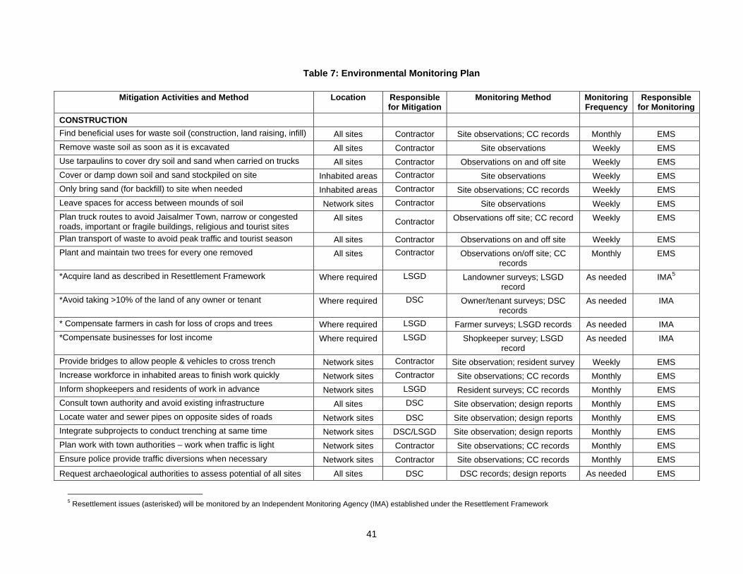
41
Table 7: Environmental Monitoring Plan
Mitigation Activities and Method Location Responsible for Mitigation
Monitoring Method Monitoring Frequency
Responsible for Monitoring
CONSTRUCTION Find beneficial uses for waste soil (construction, land raising, infill) All sites Contractor Site observations; CC records Monthly EMS Remove waste soil as soon as it is excavated All sites Contractor Site observations Weekly EMS Use tarpaulins to cover dry soil and sand when carried on trucks All sites Contractor Observations on and off site Weekly EMS Cover or damp down soil and sand stockpiled on site Inhabited areas Contractor Site observations Weekly EMS Only bring sand (for backfill) to site when needed Inhabited areas Contractor Site observations; CC records Weekly EMS Leave spaces for access between mounds of soil Network sites Contractor Site observations Weekly EMS Plan truck routes to avoid Jaisalmer Town, narrow or congested roads, important or fragile buildings, religious and tourist sites
All sites Contractor Observations off site; CC record Weekly EMS
Plan transport of waste to avoid peak traffic and tourist season All sites Contractor Observations on and off site Weekly EMS Plant and maintain two trees for every one removed All sites Contractor Observations on/off site; CC
records Monthly EMS
*Acquire land as described in Resettlement Framework Where required LSGD Landowner surveys; LSGD record
As needed IMA5
*Avoid taking >10% of the land of any owner or tenant Where required DSC Owner/tenant surveys; DSC records
As needed IMA
* Compensate farmers in cash for loss of crops and trees Where required LSGD Farmer surveys; LSGD records As needed IMA *Compensate businesses for lost income Where required LSGD Shopkeeper survey; LSGD
record As needed IMA
Provide bridges to allow people & vehicles to cross trench Network sites Contractor Site observation; resident survey Weekly EMS Increase workforce in inhabited areas to finish work quickly Network sites Contractor Site observations; CC records Monthly EMS Inform shopkeepers and residents of work in advance Network sites LSGD Resident surveys; CC records Monthly EMS Consult town authority and avoid existing infrastructure All sites DSC Site observation; design reports Monthly EMS Locate water and sewer pipes on opposite sides of roads Network sites DSC Site observation; design reports Monthly EMS Integrate subprojects to conduct trenching at same time Network sites DSC/LSGD Site observation; design reports Monthly EMS Plan work with town authorities – work when traffic is light Network sites Contractor Site observations; CC records Monthly EMS Ensure police provide traffic diversions when necessary Network sites Contractor Site observations; CC records Monthly EMS Request archaeological authorities to assess potential of all sites All sites DSC DSC records; design reports As needed EMS
5 Resettlement issues (asterisked) will be monitored by an Independent Monitoring Agency (IMA) established under the Resettlement Framework

42
Select alternatives if sites have medium or high potential All sites DSC DSC records; design reports As needed EMS Include state and town historical authorities as stakeholders All sites LSGD CC records; observations at
meetings As needed EMS
Develop and apply archaeological protocol to protect chance finds All sites DSC and CC DSC and CC records; site observations
Weekly EMS
Avoid using pneumatic drills near buildings at risk from vibration All sites Contractor Site observations; CC records Weekly EMS Use modern vehicles and machinery and maintain as specified All sites Contractor Site observations; CC records Monthly EMS Consult authorities, custodians of buildings, communities: address key issues, avoid working at sensitive times
Network sites Contractor Site observations; CC records; resident surveys
Monthly EMS
Plan work to minimise shutdown of water supply system All sites DSC Design reports; resident surveys Monthly EMS Provide alternative water to affected residents All sites LSGD Site observation; resident survey Weekly EMS Inform communities of any shutdown in advance All sites LSGD Site observation; resident survey Weekly EMS Prepare and implement a site H&S Plan (safety of workers/public) All sites Contractor Site observations; CC records Monthly EMS Exclude public from the site All sites Contractor Site observations; CC records Monthly EMS Ensure that workers wear Personal Protective Equipment All sites Contractor Site observations; CC records Monthly EMS Provide Health and Safety training for all personnel All sites Contractor CC records; worker interviews Monthly EMS Follow documented procedures for all site activities All sites Contractor Site observations; CC records Monthly EMS Keep accident reports and records All sites Contractor CC records Monthly EMS Design infrastructure to avoid known locations of AC pipes Network sites DSC DSC records; design reports As needed EMS Train all personnel in dangers and recognition of AC pipes All sites Contractor Site observations; CC records Monthly EMS Develop and apply protocol if AC pipes are encountered All sites DSC/CC DSC & CC records; site
observations Weekly EMS
If AC pipes are encountered, report to management immediately All sites Contractor Site observations; CC records Weekly EMS Remove all persons to safe distance All sites Contractor Site observations; CC records Weekly EMS Workers handling AC: wear breathing apparatus; protective suits All sites Contractor Site observations; CC records Weekly EMS All AC material must be removed and disposed of safely All sites Contractor Observations on and off site; CC
records As needed EMS
Employ at least 50% of workforce from communities near sites All sites Contractor CC records; worker interviews Monthly EMS OPERATION AND MAINTENANCE
Inform shopkeepers and residents of work in advance Network sites GA Resident surveys Monthly
Provide walkways and bridges for vehicles Network sites OM Contractor Site observation; resident survey Monthly
Request police to divert traffic if necessary Network sites OM Contractor Site observations Monthly
Avoid using drills or trucks near fragile buildings Network sites OM Contractor Site observations Monthly

43
Complete work quickly in sensitive areas Network sites OM Contractor Site observations; OMC records Monthly
Consult and inform authorities & people, avoid sensitive periods Network sites OM Contractor Site observation; resident survey Monthly
Prepare and operate H&S plan to protect workers and citizens All sites OM Contractor Site observations; OMC records Monthly
Apply AC protocol to protect all persons if AC pipes encountered All sites OM Contractor Site observations; OMC records Monthly
Employ people who live nearby to maintain OR All sites GA Employer record; worker survey Monthly
LONG-TERM SURVEYS Survey of chemical and bacteriological quality of municipal water Intake and
Domestic sites LSGD Water quality sampling and
analysis Annual for
5 years Consulting laboratory
Survey of public health and incidence of water borne disease Jaisalmer Town
LSGD Hospital records; resident surveys
Annual for 5 years
Social studies consultant

44
126. An accredited laboratory will be appointed to monitor the quality of water at the point of supply to consumers (in houses and slums), and a domestic social studies consultant will be appointed to monitor public health and the incidence of disease. These surveys will be conducted annually over the first five years of operation of the system, and require the initial collection of baseline data on pre-project conditions, during the construction period. D. Environmental management and monitoring costs 127. Most of the mitigation measures require the contractors to adopt good site practice, which should be part of their normal procedures already, so there are unlikely to be major costs associated with compliance. Regardless of this, any costs of mitigation by the contractors (those employed to construct the infrastructure or the local companies employed to conduct O&M when the system is operating) are included in the budgets for the civil works within the CTA and do not need to be estimated separately here. Mitigation that is the responsibility of LSGD will be provided as part of their management of the project, so this also does not need to be duplicated here. Costs of acquiring land and compensating shopkeepers and farmers for loss of income (Table 6) are calculated separately in the budgets for the Resettlement Framework and Resettlement Plans so are also excluded from this analysis. 128. The remaining actions in the Environmental Management Plan are:
• The environmental monitoring during construction, conducted by the EMS; and • The long-term post-construction surveys that will be commissioned by LSGD.
These have not been budgeted elsewhere, and their costs are shown in Table 8, with details of the calculations shown in footnotes beneath the table. The figures show that the total cost of environmental management and monitoring for the subproject as a whole (covering design, 1 ½ years of construction and the first five years of operation) is INR 1.8 million, ie US$ 40,000.
Table 8: Environmental management and monitoring costs (INR)
Item Quantity Unit Cost Total Cost Sub-total 1. Implementation of EMP (2 years) Domestic Environmental Monitoring Specialist 1 x 3 month 100,0006 300,000 Survey Expenses Sum 100,000 100,000 400,000 2. Survey of municipal water quality (6 years) Domestic Consultant 6 x ½ month 100,000 300,000 Sample Analysis 6 x 20 3,0007 360,000 Other Expenses Sum 200,000 200,000 860,000 3. Survey of public health (6 years) Domestic Consultant 6 x ½ month 100,000 300,000 Other Expenses Sum 200,000 200,000 500,000 TOTAL 1,760,000
6 Unit costs of domestic consultants include fee, travel, accommodation and subsistence 7 Cost of a standard suite of drinking water quality parameters (pH, turbidity, chlorinity, alkalinity, conductivity, TDS, DO, total and faecal coliforms, and selected metals) is $65 (INR 3,000) per sample

45
VIII. PUBLIC CONSULTATION AND INFORMATION DISCLOSURE A. Project stakeholders 129. Most of the main stakeholders have already been identified and consulted during preparation of this IEE, and any others that are identified during project implementation will be brought into the process in the future. Primary stakeholders are:
• Residents, shopkeepers and businesspeople who live and work alongside the roads in which network improvements will be provided and near sites where facilities will be built ;
• Owners and users of any land that is acquired along the transmission main route; • Custodians and users of socially and culturally important buildings in affected areas; • State and local authorities responsible for the protection and conservation of
archaeological relics, historical sites and artefacts; • State and local tourism authorities.
Secondary stakeholders are:
• LSGD as the Executing Agency; • Other government institutions whose remit includes areas or issues affected by the
project (state and local planning authorities, Department of Public Health Engineering, Local Government Dept, Ministry of Environment and Forests, Roads and Highways Division, etc);
• NGOs and CBOs working in the affected communities; • Other community representatives (prominent citizens, religious leaders, elders,
women’s groups); • The beneficiary community in general; and • The ADB.
B. Consultation and disclosure to date 130. Two forms of public consultation have been used during preparation of the IEE, to discuss the project and involve the community in planning the mitigation measures and develop the Environmental Monitoring Plan. These are:
• A public meeting was held in Jaisalmer Town in March 2007, to which representatives of primary and secondary stakeholders were invited. Attendees were informed about the aim of the various subprojects and the benefits they would bring, together with their likely impacts and the ways in which they would be mitigated. Participants were invited to discuss their views and concerns, which were then incorporated into the IEE. Appendix 1 contains a summary of the meeting;
• Ad hoc discussions were also held on site with people and communities who could be affected by the subprojects, so that views could be expressed in a less formal setting. These were also considered in preparing the IEE.
131. This IEE will be disclosed to the public by making it available on the ADB website, together with the IEEs prepared for the other subprojects and the summary IEE (SIEE) describing the impacts and mitigation of all subprojects.

46
C. Future consultation and disclosure 132. LSGD will extend and expand the consultation and disclosure process significantly during implementation of RUSDIP. They will appoint an experienced NGO to handle this key aspect of the programme, who will conduct a wide range of activities in relation to all subprojects in each town, to ensure that the needs and concerns of stakeholders are registered, and are addressed in project design, construction or operation where appropriate. The programme of activities will be developed during the detailed design stage, and is likely to include the following: Consultation during detailed design:
• Focus-group discussions with affected persons and other stakeholders (including women’s groups, NGOs and CBOs) to hear their views and concerns, so that these can be addressed in subproject design where necessary;
• Structured consultation meetings with the institutional stakeholders (government bodies and NGOs) to discuss and approve key aspects of the project.
Consultation during construction:
• Public meetings with affected communities to discuss and plan work programmes and allow issues to be raised and addressed once construction has started;
• Smaller-scale meetings to discuss and plan construction work with individual communities to reduce disturbance and other impacts, and provide a mechanism through which stakeholders can participate in subproject monitoring and evaluation;
Project disclosure:
• Public information campaigns (via newspaper, TV and radio) to explain the project to the wider city population and prepare them for disruption they may experience once the construction programme is underway;
• Public disclosure meetings at key project stages to inform the public of progress and future plans, and to provide copies of summary documents in Hindi;
• Formal disclosure of completed project reports by making copies available at convenient locations in the study towns, informing the public of their availability, and providing a mechanism through which comments can be made.
IX. FINDINGS AND RECOMMENDATIONS A. Findings 133. The process described in this document has assessed the environmental impacts of all elements of the infrastructure proposed under the Jaisalmer Water Supply Subproject. Potential negative impacts were identified in relation to both construction and operation of the improved infrastructure, but no impacts were identified as being due to either the project design or location. Mitigation measures have been developed to reduce all negative impacts to acceptable levels. These were discussed with specialists responsible for the engineering aspects, and as a
47
result some measures have already been included in the outline designs for the infrastructure. These include:
• Locating all pipelines within the ROW of existing roads, to avoid the need to acquire land or relocate people;
• Locating pipelines on unused land adjacent to roads wherever possible, to avoid damaging roads and disrupting traffic and other activities.
This means that the number of impacts and their significance has already been reduced by amending the design. 134. Changes have also been made to the location of elements of the project to further reduce impacts. These include:
• Locating all facilities on government-owned land to avoid the need for land acquisition and relocation of people;
• Locating the 57 km transmission main in the ROW alongside a main road, to reduce the acquisition of agricultural land and impacts on livelihoods of farmers and workers.
135. Regardless of these and various other actions taken during the IEE process and in developing the project, there will still be impacts on the environment when the infrastructure is built and when it is operating. This is mainly because of the invasive nature of trenching and other excavation; because the distribution network is located in an ancient town where there are densely populated areas and sites of historical and tourism interest; and because Rajasthan is an area with a rich history, so there is a high risk that ground disturbance may uncover important remains. Because of these factors the most significant impacts are on the physical environment, the human environment, tourism, and the cultural heritage. 136. During the construction phase, impacts mainly arise from the need to dispose of large quantities of waste soil and import a similar amount of sand to support the pipes in the trenches; and from the disturbance of residents, businesses, traffic and important buildings by the construction work. These are common impacts of construction in urban areas, and there are well developed methods for their mitigation. These include:
• Finding beneficial uses for waste material; • Covering soil and sand during transportation and when stored on site; • Planning work to minimise disruption of traffic and communities; • Providing temporary structures to maintain access across trenches where required.
137. There could also be a need to acquire small amounts of farm land along the route of the transmission main, where it is impracticable for the pipeline to follow bends in the road. Such impacts are also frequently encountered and are dealt with by a combination of the legal process and additional measures required by ADB policy on Involuntary Resettlement. Actions are discussed in a separate Resettlement Plan and Resettlement Framework, and include:
• Acquisition of land through the GOI Land Acquisition Act, through which the market value is paid, based on an analysis of recent transactions;
• Ensuring that no more than 10% of the land of a single owner or tenant is acquired; • Providing additional compensation for loss of standing crops and productive trees.
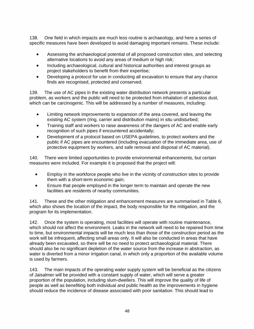
48
138. One field in which impacts are much less routine is archaeology, and here a series of specific measures have been developed to avoid damaging important remains. These include:
• Assessing the archaeological potential of all proposed construction sites, and selecting alternative locations to avoid any areas of medium or high risk;
• Including archaeological, cultural and historical authorities and interest groups as project stakeholders to benefit from their expertise;
• Developing a protocol for use in conducting all excavation to ensure that any chance finds are recognised, protected and conserved.
139. The use of AC pipes in the existing water distribution network presents a particular problem, as workers and the public will need to be protected from inhalation of asbestos dust, which can be carcinogenic. This will be addressed by a number of measures, including:
• Limiting network improvements to expansion of the area covered, and leaving the existing AC system (ring, carrier and distribution mains) in situ undisturbed;
• Training staff and workers to raise awareness of the dangers of AC and enable early recognition of such pipes if encountered accidentally;
• Development of a protocol based on USEPA guidelines, to protect workers and the public if AC pipes are encountered (including evacuation of the immediate area, use of protective equipment by workers, and safe removal and disposal of AC material).
140. There were limited opportunities to provide environmental enhancements, but certain measures were included. For example it is proposed that the project will:
• Employ in the workforce people who live in the vicinity of construction sites to provide them with a short-term economic gain;
• Ensure that people employed in the longer term to maintain and operate the new facilities are residents of nearby communities.
141. These and the other mitigation and enhancement measures are summarised in Table 6, which also shows the location of the impact, the body responsible for the mitigation, and the program for its implementation. 142. Once the system is operating, most facilities will operate with routine maintenance, which should not affect the environment. Leaks in the network will need to be repaired from time to time, but environmental impacts will be much less than those of the construction period as the work will be infrequent, affecting small areas only. It will also be conducted in areas that have already been excavated, so there will be no need to protect archaeological material. There should also be no significant depletion of the water source from the increase in abstraction, as water is diverted from a minor irrigation canal, in which only a proportion of the available volume is used by farmers. 143. The main impacts of the operating water supply system will be beneficial as the citizens of Jaisalmer will be provided with a constant supply of water, which will serve a greater proportion of the population, including slum-dwellers. This will improve the quality of life of people as well as benefiting both individual and public health as the improvements in hygiene should reduce the incidence of disease associated with poor sanitation. This should lead to

49
economic gains as people will be away from work less and will spend less on healthcare, so their incomes should increase. 144. Table 6 also assesses the effectiveness of each mitigation measure in reducing each impact to an acceptable level. This is shown as the level of significance of the residual impact (remaining after the mitigation is applied). This shows that all impacts will be rendered at least neutral (successfully mitigated), and that certain measures will produce a benefit (in addition to the major benefits provided by the operating schemes). 145. Mitigation will be assured by a programme of environmental monitoring conducted during both construction and operation to ensure that all measures are provided as intended, and to determine whether the environment is protected as envisaged. This will include observations on and off site, document checks, and interviews with workers and beneficiaries, and any requirements for remedial action will be reported to the IPMU. There will also be longer-term surveys to monitor the expected improvements in the quality of domestic water and the health of the population. 146. Finally, stakeholders were involved in developing the IEE through both face-to-face discussions on site and a large public meeting held in the town, after which views expressed were incorporated into the IEE and the planning and development of the project. The IEE will be made available at public locations in the town and will be disclosed to a wider audience via the ADB website. The consultation process will be continued and expanded during project implementation, when a nationally-recognised NGO will be appointed to handle this key element to ensure that stakeholders are fully engaged in the project and have the opportunity to participate in its development and implementation. B. Recommendations 147. There are two straightforward but essential recommendations that need to be followed to ensure that the environmental impacts of the project are successfully mitigated. These are that LSGD should ensure that:
• All mitigation, compensation and enhancement measures proposed in this IEE report (Table 6) and in the Resettlement Framework for the RUSDIP are implemented in full, as described in these two documents;
• The Environmental Monitoring Plan proposed in Section VI.C of this report and the internal and external monitoring proposed in the Resettlement Framework are also implemented in full.
X. CONCLUSIONS 148. The environmental impacts of the proposed improvements in water supply and distribution infrastructure in Jaisalmer Town have been assessed by the Initial Environmental Examination reported in this document, conducted according to ADB guidelines. Issues related to Involuntary Resettlement were assessed by a parallel process of resettlement planning and will be compensated by measures set out in detail in the Resettlement Framework for the subproject. These measures were integrated into the IEE and are summarised in this report.

50
149. The overall conclusion of both processes is that providing the mitigation, compensation and enhancement measures are implemented in full, there should be no significant negative environmental impacts as a result of location, design, construction or operation of the subproject. There should in fact be some small benefits from recommended mitigation and enhancement measures, and major improvements in quality of life and individual and public health once the scheme is in operation. 150. There are no uncertainties in the analysis, and no further studies are required to comply with ADB procedure or national law. There is thus no need for further study or Environmental Assessment.

48
Photo 1a: IGNP Main canal at Modangarh Photo 3: Water main alignment along road Photo 1b: Mandau distributory at Mohangarh Photo 4: Overhead Reservoir Photo 2: Site for raw water resevoirs Photo 5: Water supply pumping system
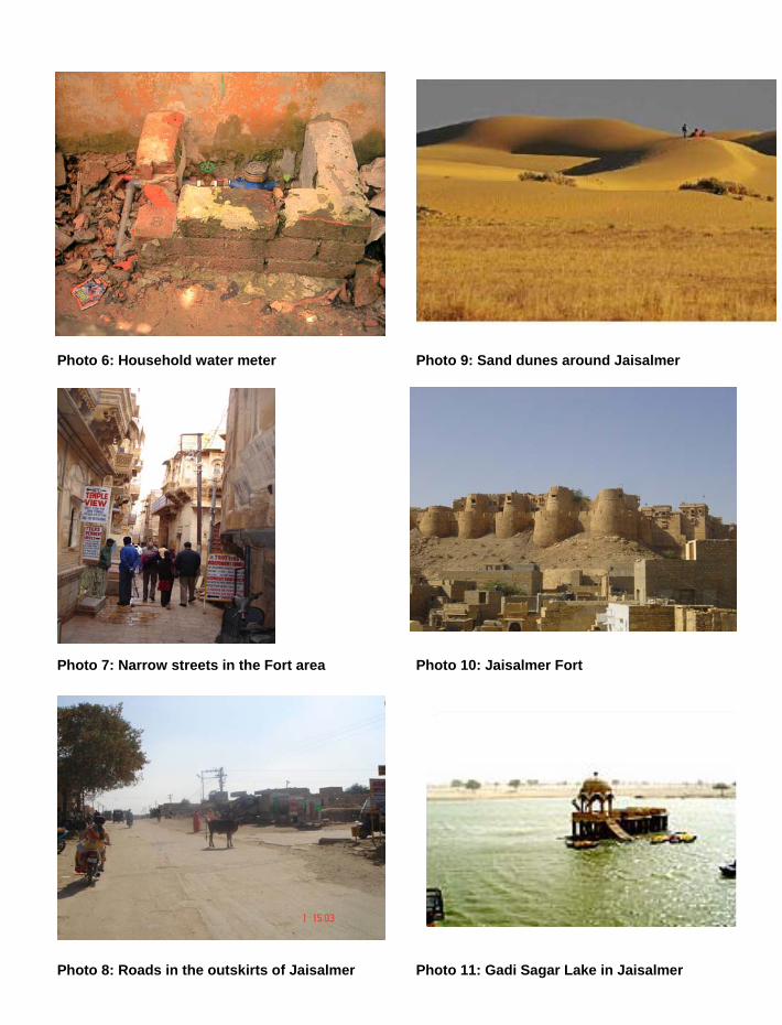
49
Photo 6: Household water meter Photo 9: Sand dunes around Jaisalmer Photo 7: Narrow streets in the Fort area Photo 10: Jaisalmer Fort Photo 8: Roads in the outskirts of Jaisalmer Photo 11: Gadi Sagar Lake in Jaisalmer

50
Photo 12: Natural vegetation around Jaisalmer Photo 15: Thick vegetation along the canal Photo 13: Jaisalmer handicrafts Photo 16: Encroachments on roadside drain Photo 14: A haveli in Jaisalmer Photo 17: Backhoe digger
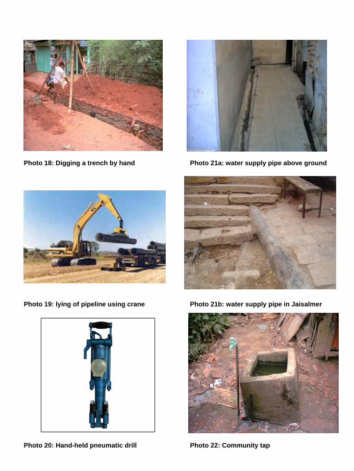
51
Photo 18: Digging a trench by hand Photo 21a: water supply pipe above ground Photo 19: lying of pipeline using crane Photo 21b: water supply pipe in Jaisalmer Photo 20: Hand-held pneumatic drill Photo 22: Community tap