Embed Size (px)
Citation preview
INDIAN CLAIMS COMMISSION
WALPOLE ISLAND FIRST NATION INQUIRY
BOBLO ISLAND CLAIM
PANEL
Commission Co-Chair Daniel J. BellegardeCommissioner Roger J. Augustine
COUNSEL
For the Walpole Island First NationRussel Raikes
For the Government of CanadaRobert Winogron
To the Indian Claims CommissionDavid E. Osborn, QC / Ralph Keesickquayash
May 2000
CONTENTS
EXECUTIVE SUMMARY v
PART I INTRODUCTION 1
BACKGROUND TO THE INQUIRY 1MANDATE OF THE COMMISSION 3
PART II HISTORICAL BACKGROUND 7
EARLY CONTACTS 7POLICY REGARDING ABORIGINAL LANDS 12THE ROYAL PROCLAMATION OF 1763 14LAND GRANTS TO SCHIEFFELIN AND THE INDIAN OFFICERS, 1783–84 19THE 1786 SURRENDER 27THE 1790 TREATY 35BOIS BLANC (BOBLO) ISLAND AFTER 1790 42
PART III ISSUES 51
PART IV ANALYSIS 53
ISSUE 1: Does the Surrender of May 15, 1786, Contravene the Provisions of the Royal Proclamation of 1763? 53Applicability of the Royal Proclamation 53Requirements of the Royal Proclamation 57
Instructions, Licence, or Permission to Obtain a Surrender 60General Meeting or Assembly with the Principal Chiefs 62Purchase of Lands 63Assembly in the Presence of High Officials 66
Comparison of the 1786 and 1790 Surrenders 66Intention of the Parties 67Extinguishment 75
ISSUE 2: (a) Were the Chiefs and Principal Men of the Walpole Island First Nation Signatories to the Alleged Surrender of May 15, 1786? 79(b) If They Were Not, Does This Make the Surrender Invalid with Respect to the Walpole Island First Nation? 81
ISSUE 3: Was There Consideration for the Transfer? 81ISSUE 4: If There Was Not, Does This Render the Surrender Invalid? 81ISSUE 5: (a) Did the Crown and/or Indians Regard the Surrender of 1786
as Invalid When They Entered into the Surrender of 1790? 81(b) If So, What Is the Effect of the 1790 Surrender on the Alleged Surrender of 1786? 83
ISSUE 6: Is the Crown Estopped from Relying upon the Surrender of 1786? 83ISSUE 7: Did the Crown Breach Its Fiduciary Obligations in Obtaining the
Surrender? 85
PART V CONCLUSIONS AND RECOMMENDATION 87
APPENDIX
A Walpole Island First Nation Boblo Island Inquiry 89
EXECUTIVE SUMMARY
BACKGROUND TO THE INQUIRY
In August 1992, the Walpole Island First Nation submitted a specific claim to the Department of
Indian and Northern Affairs in relation to the First Nation’s claim to Boblo (formerly known as Bois
Blanc) Island, an island in the Detroit River. The Walpole Island First Nation alleged, among other
things, that Surrender 116, dated May 15, 1786, had breached the terms of the Royal Proclamation
of 1763 and that the surrender was made without compensation to the Walpole Island First Nation.
On March 31, 1995, Canada rejected the claim.
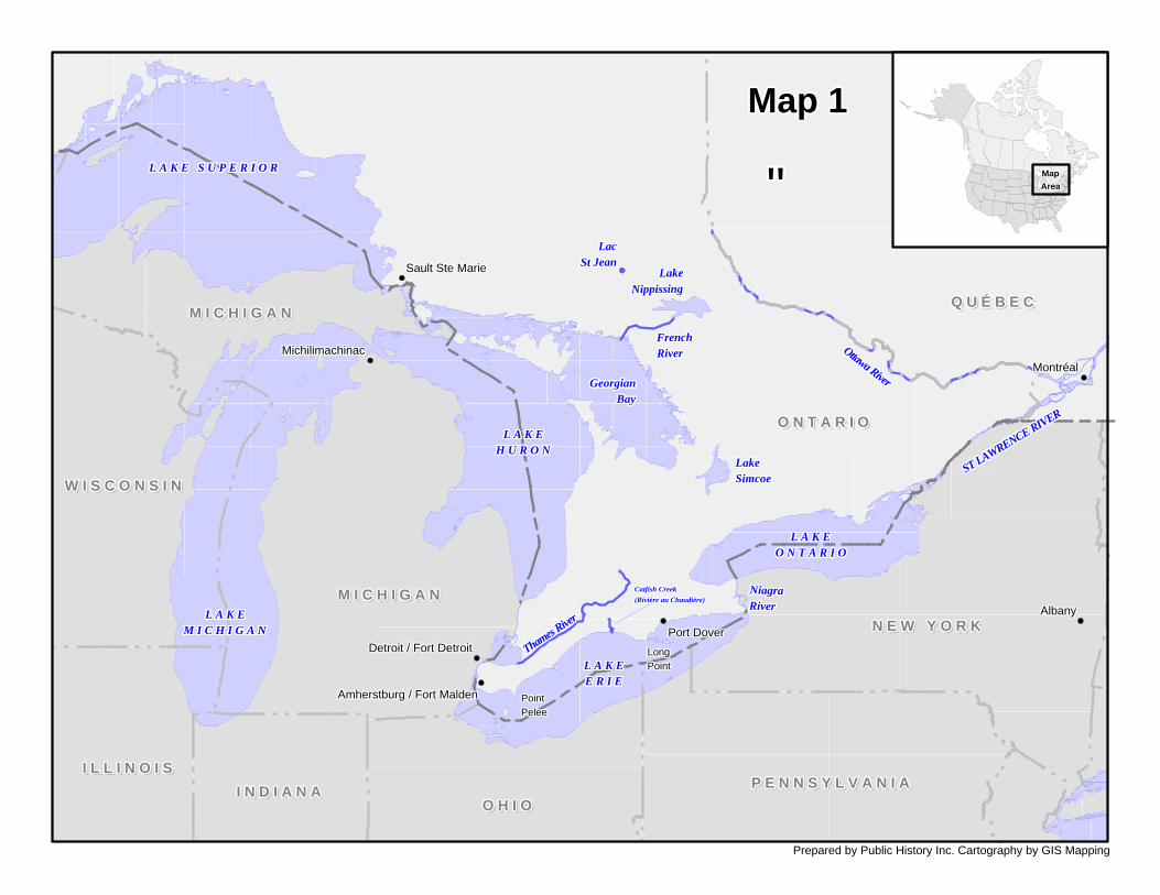
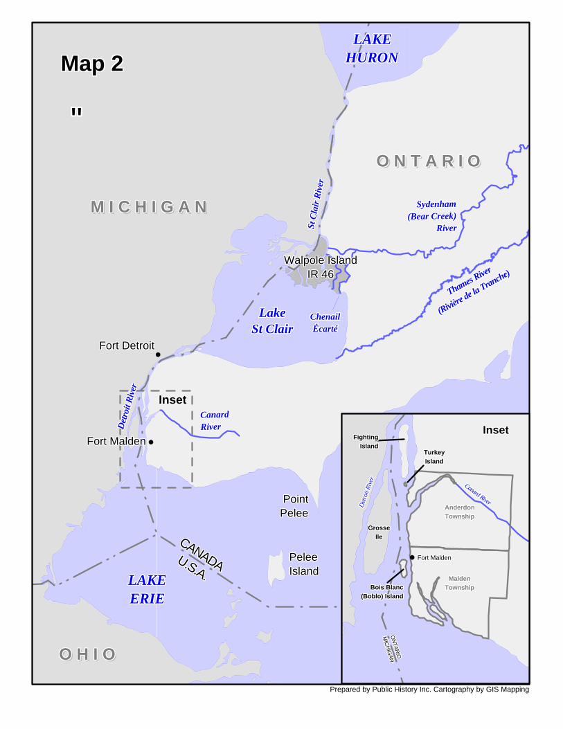
Both Walpole Island and Boblo Island are located in southwestern Ontario – Walpole at the
confluence of Lake St Clair and the St Clair River; Boblo in the Detroit River near the entrance to
Lake Erie.
Four Indian tribes in the region formed a Lake Confederacy – the Huron, Ottawa, Chippewa,
and Potawatomi. There is little information, however, as to which of these groups occupied Boblo
Island. In 1721, a Jesuit priest, Pierre-François-Xavier Charlevoix, described his trip to the area. He
noted that he “spent the night above a beautiful island called the Island of Bois Blanc,” but did not
mention meeting any Indians there. In 1742, the Jesuits removed most of the Huron from a mission
near Fort Detroit and settled them on Bois Blanc Island and the adjacent mainland on the east side
of the river. A 1747 manuscript lists 534 persons, plus an unknown number of children, in the
“Huron village of the Island of Bois Blancs.” The mission was abandoned in 1748 and moved across
the river from Fort Detroit.
POLICY REGARDING ABORIGINAL LANDS
On October 7, 1763, King George III issued the Royal Proclamation. The Detroit River/Lake St Clair
region is well within the vast area reserved by the Proclamation for Indian use. According to the
Proclamation, aboriginal peoples in the area possessed aboriginal title to their lands which could
only be extinguished by negotiation with the Crown.
When lands were required, and when an Indian group was willing to sell its land, Crown
representatives were to meet the concerned Indians in a public meeting to make the purchase for and
in the name of the Crown. This land purchase policy was stressed in instructions sent to Governor
vi Indian Claims Commission
James Murray in December 1763. However, in direct contravention of the Proclamation, private land
sales between British subjects and some of the Chiefs took place in the Detroit area. In 1771, General
Thomas Gage, Commander-in-Chief of the British forces at New York, wrote to the commander at
Detroit stating that all previous grants were to be voided, since the sales were made without the
King’s permission and authority.
LAND GRANTS TO SCHIEFFELIN AND THE INDIAN OFFICERS, 1783–84
Early in 1783, two officers, Captains William Caldwell and Matthew Elliott, along with Captain
Henry Bird and Deputy Indian Agent Alexander McKee, were negotiating with the local Huron for
a “deed” to a seven-mile block of land along the Detroit River across from Bois Blanc Island. Before
they could conclude that transaction, however, Lieutenant Jacob Schieffelin, Secretary of the Indian
Department at Detroit, obtained deeds for the land from some Ottawa, Chippewa, and Potawatomi
Chiefs. Only the deed to the Ottawa was registered and survives. According to the terms of this deed,
seven “Principal Village Chiefs and War Chiefs of the Ottawa Nation residing near Detroit” granted
Schieffelin a “tract or parcel of Land of seven miles in front and seven miles in depth on the south
side of the Detroit River, opposite the Isle au Bois blanc.” The grant was made “in consideration of
our affection and esteem” for Schieffelin and specified no payment in money or goods.
McKee and Bird wrote letters of complaint as soon as they heard rumours of the transaction.
Within a week, Chiefs of the local Ottawa, Chippewa, and Huron began a series of four councils
with McKee and others to accuse Schieffelin of deceit and to plead for the return of the deed.
Governor Frederick Haldimand wrote to Lieutenant Governor Jehu Hay of Detroit on April
26, 1784, denying Schieffelin’s claim and, at the same time, emphasizing the impropriety of all such
grants to individuals rather than the Crown. However, Haldimand did not rule out consideration of
the application made by Caldwell and the others to these same lands. On June 8, 1784, the Indian
officers received a grant to the seven-mile-square block, plus a larger area adjacent to it. The second
grant was made by Ottawa Chiefs and names the grantees as Alexander McKee, William Caldwell,
Matthew Elliott, and Thomas McKee.
Caldwell renewed the officers’ settlement application to Governor Haldimand, stating that
“the Indians are equally desirous with them for the speedy and effectual settling of the same as well
Walpole Island First Nation Boblo Island Inquiry vii
as from a political view as on account of the Regard they bear them, having so long served in the
field together.” Haldimand admitted that he could not confirm the “gift” until there was a proper
surrender, but gave his permission for the officers to settle on and improve their lots. He directed
McKee to explain to the Indians the steps required to effect a legal grant of land.
The lots for the officers and others were surveyed the following year by Deputy Surveyor
Philip Fry, who described them as granted by the “Indians to the Loyalists.” Fry had been ordered
by Hay to set out four lots of six acres each for Bird, McKee, Caldwell, and Elliott, but discovered
that they had by then occupied 10 acres each, “the whole space opposite to the Isle Bois Blanc.”
THE 1786 SURRENDER
Despite his superior’s clearly stated rules and his own admonition to Schieffelin that purchases from
Indians were to be taken from the proper Chiefs, in public, Deputy Indian Agent Alexander McKee
obtained a surrender in the name of the Crown on May 15, 1786, from Chippewa and Ottawa Chiefs
of both Bois Blanc Island and a seven-mile-square block across the channel, immediately north of
the Indian officers’ grant. Research conducted on behalf of both parties concluded that none of the
signatories to the 1786 surrender could be specifically linked to the Walpole Island First Nation.
Extensive research conducted over a number of years on behalf of both Canada and the First Nation
failed to produce the documents usually associated with a purchase of land from the Indians.
In 1788, District Land Boards were established to receive and report on applications for land
from settlers. McKee was a member of the Land Board of Hesse from its inception. In June 1789,
the Governor, Guy Carleton, Baron Dorchester, instructed the Board to immediately establish a
settlement, to be called George Town, at a location directly opposite Bois Blanc Island. On August
14, 1789, the Board reported that McKee had informed it that the particular location required for a
town site had never been surrendered by the Indians, except for the area covered by the 1784 grant
to the Indian officers.
On August 28, 1789, board members reported that it was impossible for them to comply with
the general instructions for locating settlers because, according to information given to them by
McKee, none of the lands in the District of Hesse has been surrendered to the Crown. The Governor
viii Indian Claims Commission
wrote to the Superintendent of Indian Affairs, Sir John Johnson, shortly after and clearly stated that
previous purchases or grants from the Indians by individuals were totally void.
At some point before the end of 1789, McKee submitted his deed to the lands included in the
1786 surrender and an accompanying memorial directly to Governor Dorchester, instead of to the
Land Board. On January 21, 1790, Dorchester’s secretary forwarded the deed and memorial to the
Land Board for its consideration, while at the same time stating the Governor’s opinion that the June
1784 deed presented the only equitable claim on lands in Hesse.
McKee’s memorial to Dorchester has not been found. It seems to have referred to McKee’s
desire to use the lands not for himself but for those Loyalists he deemed worthy. McKee relinquished
his interest in or claim to the land in a letter to Sir John Johnson on May 25, 1790, stating that the
surrender was made to him to ensure that the Huron were protected from encroachments by others.
In an undated memo (possibly written in the summer of 1790), Major Patrick Murray, the
Commanding Officer at Detroit, echoed McKee’s interpretation of the events surrounding the May
1786 agreement.
The Land Council at Quebec conducted an investigation in 1830 into Indian ownership of
lands along the Detroit River. The Council questioned the exclusion of the Huron and Potawatomi
who were occupying the area at the time from consent to the 1786 deed. As well, it noted that
McKee’s declaration that the lands were to be protected for the Huron was “not very easy to be
reconciled with the terms of the Deed, or with his own subsequent application to Lord Dorchester
and to the Land Board.”
THE 1790 TREATY
As soon as Governor Dorchester learned that settlement in the District of Hesse was impeded
because the Indians still owned the land, he began the process to purchase the area. On August 17,
1789, he instructed the Superintendent of Indian Affairs, Sir John Johnson, to direct McKee to take
a treaty with the Indians in the District of Hesse to obtain the tract needed for settlement. On
December 7, 1789, the Board recommended that McKee obtain a cession of a tract “bounded by the
waters of the River and Lake St. Clare [sic], Detroit [River] and Lake Erie.”
Walpole Island First Nation Boblo Island Inquiry ix
McKee obtained the surrender on May 19, 1790. Minutes of the council with the Indians for
that day, as well as journal entries, indicate that the negotiations towards the surrender took place
over a number of weeks. Attending for the government on the day of surrender were the
Commanding Officer of the fort, as well as Alexander McKee,14 named army and navy officers, and
an unknown number of officers of the militia, magistrates, and general citizens. The acting clerk
recorded the session. The Indians were represented by 35 Chiefs. Of those, three of the Chippewa
Chiefs and one of the Ottawa Chiefs had also signed the 1786 deed/surrender. Research conducted
for the parties concluded that the 1790 signatories represented Thames River, Pelee Island/Anderdon,
Walpole Island, St Clair River, and Bear Creek (Sydenham River) regional bands in what is now
southwestern Ontario, as well as bands in what is now southeastern Michigan.
Two areas in the ceded tract were reserved for the Indians – a small area near Sandwich and
a larger block in the same place at the River Canard described in McKee’s 1786 deed, which was
reserved for the Huron and other Indians. Bois Blanc Island was not included in the surrender. The
sale price of the tract was £1,200 Quebec currency, provided in “valuable wares and merchandise”
such as blankets, strouds, cloth, hats, knives, rifles, powder, shot, and other items.
McKee reported to the Land Board of Hesse on May 21, 1790, that he had successfully
obtained the cession of land except for two areas to be reserved for the Indians, one of which was
“a tract beginning at the Indian officers Land running up the Streight to the French settlement and
seven miles in depth.” Some members of the Board objected to the reservation of lands, which they
believed had been surrendered on May 15, 1786. When the subject was discussed by the Board on
May 28, 1790, two members, Major Patrick Murray and Alexander Grant, disagreed with this view
and expressed concern that the Board was giving opinions to the Governor on matters relating to
Indian affairs.
It is important to note that much of the same land purportedly surrendered in 1786 (the
mainland tract) was in fact reserved for the Huron and other Indians in 1790.
ISSUES
The parties agreed that the primary issue to resolve was whether the surrender of May 15, 1786,
contravened the provisions of the Royal Proclamation of 1763. Other issues, such as whether there
x Indian Claims Commission
was consideration for the surrender, were subsumed under this larger issue. These secondary issues
included whether the Walpole Island First Nation was a signatory to the May 15, 1786, surrender;
what the effect of the 1790 surrender was on the alleged surrender of 1786; whether the Crown is
estopped from relying on the surrender of 1786; and whether the Crown breached its fiduciary
obligations in obtaining the surrender.
The parties agreed that, if the surrender were found to be invalid, it would result in a finding
of unextinguished aboriginal title.
ANALYSIS
To determine the validity of the 1786 surrender requires, first, an assessment of whether the
provisions of the Royal Proclamation of 1763 were complied with. Although Canada has argued that
the Royal Proclamation does not apply to this area, there is ample authority to the contrary, including
the geographic terms of the Proclamation itself.
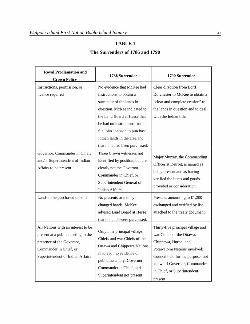
Table 1 sets out the requirements of the Proclamation and compares the 1786 surrender
(which is in question in these proceedings) with the 1790 surrender (which is considered valid by
the parties) in terms of whether these requirements were complied with in 1786.
McKee had no authority in 1786 to take a surrender; no consideration passed in the form of
gifts or other compensation; and the formalities of a surrender, in terms of a public meeting with
representatives present from every tribe with an interest in the land, were not complied with. The
provisions of the Royal Proclamation of 1763, then, were not complied with. However, to determine
whether this noncompliance is sufficient to invalidate the surrender requires further consideration
of what the parties intended.
The evidence as to what McKee intended is unclear. He had no authority to take a surrender.
However, his comments to the effect that the lands were to be reserved for the Huron in 1786 are
inconsistent with the terms of the surrender itself, which is unconditional. As well, his application
for the transfer of the lands into his own name four years later is troubling. For that reason alone, we
Walpole Island First Nation Boblo Island Inquiry xi
TABLE 1
The Surrenders of 1786 and 1790
Royal Proclamation and
Crown Policy 1786 Surrender 1790 Surrender
Instructions, permission, or
licence required
No evidence that McKee had
instructions to obtain a
surrender of the lands in
question. McKee indicated to
the Land Board at Hesse that
he had no instructions from
Sir John Johnson to purchase
Indian lands in the area and
that none had been purchased.
Clear direction from Lord
Dorchester to McKee to obtain a
“clear and complete cession” to
the lands in question and to deal
with the Indian title.
Governor, Commander in Chief,
and/or Superintendent of Indian
Affairs to be present
Three Crown witnesses not
identified by position, but are
clearly not the Governor,
Commander in Chief, or
Superintendent General of
Indian Affairs.
Major Murray, the Commanding
Officer at Detroit, is named as
being present and as having
verified the items and goods
provided as consideration.
Lands to be purchased or sold No presents or money
changed hands: McKee
advised Land Board at Hesse
that no lands were purchased.
Presents amounting to £1,200
exchanged and verified by list
attached to the treaty document.
All Nations with an interest to be
present at a public meeting in the
presence of the Governor,
Commander in Chief, or
Superintendent of Indian Affairs
Only nine principal village
Chiefs and war Chiefs of the
Ottawa and Chippewa Nations
involved; no evidence of
public assembly; Governor,
Commander in Chief, and
Superintendent not present
Thirty-five principal village and
war Chiefs of the Ottawa,
Chippewa, Huron, and
Potawatomi Nations involved;
Council held for the purpose; not
known if Governor, Commander
in Chief, or Superintendent
present.
xii Indian Claims Commission
rejected Canada’s alternative argument that the surrender reflected the Sovereign’s “clear and plain”
intention to extinguish any aboriginal interest in the lands.
It is apparent from the statements made by McKee and Murray that, whatever McKee’s
intention may have been, the aboriginal parties to the transaction in 1786 intended to reserve lands.
As such, the surrender not only fails to comply with the formalities of the Royal Proclamation, but
also fails to accord with the Crown’s policy that lands must be voluntarily ceded. The surrender is
therefore invalid.
As well, the 1790 surrender is necessarily inconsistent with the 1786 surrender and may be
interpreted as revoking it, in that it reserves the mainland lands which were supposedly surrendered
in 1786. There is no basis on which to draw a distinction between the mainland and the island in
terms of the 1786 “surrender,” since both were dealt with together. The 1790 surrender did not
include the island, so whatever aboriginal title was held to the island in 1786 continues to this day.
The question of whether the ancestors of the Walpole Island First Nation were signatories
to the 1786 surrender is somewhat academic, since the surrender is not valid with respect to anyone.
However, although evidence of who signed the surrender is not complete, it is sufficient to determine
that the ancestors of the Walpole Island First Nation probably did not sign it. By contrast, they were
present in 1790.
On the issue of whether the Crown is estopped from relying on the surrender, in light of the
representations of McKee that the surrender he obtained in 1786 was intended to reserve lands for
the use of the Huron, the Crown would be estopped from relying on the surrender document as
reflecting an intention to surrender lands.
In light of these findings, it was not necessary to deal with the other issues.
CONCLUSIONS AND RECOMMENDATION
The surrender of May 15, 1786, is invalid on two grounds: it did not comply with the provisions of
the Royal Proclamation of 1763; and contextual information indicates that the signatories to the
surrender understood it would reserve lands, not surrender them. If that conclusion is wrong, we
would find that a 1790 surrender, which reserved most of the same lands as those purportedly
Walpole Island First Nation Boblo Island Inquiry xiii
surrendered in 1786, is necessarily inconsistent with the provisions of the 1786 surrender and
therefore revoked it. As a result, the surrender is of no force or effect.
Given that Bois Blanc Island has not been the subject of any other surrenders and was not
surrendered in 1790, whatever aboriginal title may have existed to Bois Blanc Island in 1786
continues.
It is therefore recommended that the Walpole Island First Nation resubmit its claim to the
federal government under the Comprehensive Claims Policy.
1 Letter from Pamela Keating, Research Manager, Specific Claims East/Central, Department of Indianand Northern Affairs Canada, to Chief Joseph B. Gilbert, Walpole Island First Nation, March 31, 1995 (ICC PlanningConference Kit, July 12, 1996, tab 7).
2 Chief Joseph B. Gilbert, Walpole Island First Nation, to Pamela Keating, Research Manager, SpecificClaims East/Central, Department of Indian and Northern Affairs Canada, May 15, 1995 (ICC Planning Conference Kit,July 12, 1996, tab 8).
PART I
INTRODUCTION
BACKGROUND TO THE INQUIRY
In August 1992, the Walpole Island First Nation submitted a specific claim to the Department of
Indian Affairs and Northern Development (DIAND) in relation to the First Nation’s claim to Boblo
(formerly known as Bois Blanc) Island, an island in the Detroit River. The Walpole Island First
Nation alleged, among other things, that Surrender 116, dated May 15, 1786, had breached the terms
of the Royal Proclamation of 1763 and that the surrender was made without compensation to the
First Nation.
On March 31, 1995, Canada rejected the claim, advising that members from DIAND and the
Department of Justice would be pleased to meet with the First Nation to discuss Canada’s
preliminary position and further steps to be taken on the specific claims process.1
On May 15, 1995, in preparation for a proposed meeting with Canada’s representatives, the
Walpole Island First Nation made a number of additional allegations relating to Surrender 116.
These charges included an allegation that the surrender was fraudulent, in that it had been made
without monetary compensation; that the surrender was not valid, as it had not been signed by the
Crown and nothing was known about the Indian signatories; and that the island was not surrendered
to the Crown, but, rather, had been surrendered in trust for the First Nation.2
On November 24, 1995, Canada rejected these additional grounds for the claim, advising
that, in its view, “there is no outstanding lawful obligation on the part of the government of Canada
owed to the Walpole Island First Nation.” Pamela Keating, Research Manager, Specific Claims
East/Central, Indian and Northern Affairs Canada, added:
I should point out that the Walpole Island First Nation has the option to submit arejected claim to the Indian Specific Claims Commission and request that the
2 Indian Claims Commission
3 Letter from Pamela Keating, Research Manager, Specific Claims East/Central, Department of Indianand Northern Affairs Canada, to Chief Joseph B. Gilbert, Walpole Island First Nation, November 24, 1995 (ICCPlanning Conference Kit, July 12, 1996, tab 9).
4 Robert Winogron, DIAND, legal counsel, to Russel Raikes, counsel for the Walpole Island FirstNation, March 23, 1998 (ICC file 2105-09-03, vol. 2).
Commission hold an inquiry into the reasons for the rejection. Should the FirstNation prefer to proceed on that basis, without submitting additional evidence orlegal arguments, then this letter will serve as evidence, for the purposes of theCommission, that the Government of Canada could not accept this claim fornegotiation under the Specific Claims Policy.3
On April 9, 1996, the First Nation requested that the Indian Claims Commission (ICC)
conduct an inquiry into the rejection of its claim. On April 26, 1996, the Commission agreed to do
so. A planning conference was held on July 12, 1996, at which time the parties agreed to the issues
to be reviewed by the Commission. At that time, no challenge was made concerning the
Commission’s mandate, as the claim had been rejected under Canada’s Specific Claims Policy.
However, almost two years later, on March 23, 1998, Canada challenged the mandate of the
Commission to conduct an inquiry into some of the identified issues. Canada argued that, should it
be determined that the claimant was not a signatory to the 1786 surrender, the claim would be based
on unextinguished aboriginal title and would therefore fall outside the jurisdiction of the ICC.4
The Commission’s mandate is to inquire into “only those matters at issue when the dispute
was initially submitted to the Commission.” A jurisdictional objection of the type raised in 1998
should, in our opinion, have been introduced at the outset, and not two years into the review process.
However, we dismiss the objection for the following reasons. The claim, we note, was not rejected
by Canada on the basis that the evidence disclosed unextinguished aboriginal title, but, rather, on the
basis that the surrender of 1786 was valid. Having rejected the claim on the basis of a valid
surrender, Canada was unwilling to take a position on whether the Walpole Island First Nation was
or was not a signatory to the surrender. Instead, Canada argued that the ICC lacked jurisdiction to
conduct an inquiry should it find that the Walpole Island First Nation was not a signatory.
Further, so long as Canada asserts that the 1786 surrender is a defence to the Walpole Island
First Nation’s claim, the claim must necessarily continue within the Specific Claims process. If the
Walpole Island First Nation Boblo Island Inquiry 3
5 Commission issued September 1, 1992, pursuant to Order in Council PC 1992-1730, July 27, 1992,amending the Commission issued to Chief Commissioner Harry S. LaForme on August 12, 1991, pursuant to Order inCouncil PC 1991-1329, July 15, 1991.
Walpole Island First Nation is not a signatory to the surrender, Canada has raised other alternative
arguments relating to extinguishment which we must also address. In other words, Canada asserts
that, if we make a certain finding after reviewing the evidence, we will be precluded from conducting
an inquiry. We find this submission circuitous. Before we can determine the question of whether the
Walpole Island First Nation is a signatory or not, however, we must first review the evidence.
Canada’s position is really that we lack jurisdiction because, once we review the evidence
presented, we may find “unextinguished aboriginal title.” To reach that conclusion at this stage, we
would have to conclude that the Walpole Island First Nation was not a signatory to the document
before reviewing any evidence. This matter has been put in dispute by the parties’ own submissions.
We would also have to ignore Canada’s alternative arguments to the effect that aboriginal title was
extinguished, in any event, as a result of the surrender. We would prefer to conduct the inquiry
without fettering our discretion, and review all the evidence before reaching any conclusions.
We are charged with the responsibility to inquire into Canada’s rejection of the claim once
requested to do so by the claimant, on the basis of Canada’s Specific Claims Policy. Depending on
the outcome of our inquiry, we may or may not agree with Canada that the matter involves
unextinguished aboriginal title. If we do come to this conclusion, however, it will be a finding that
falls within – not outside – our mandate.
A summary of the written submissions, documentary evidence, transcripts, and the balance
of the record in this inquiry is set forth in Appendix A of this report.
MANDATE OF THE COMMISSION
The mandate of the Commission is set out in federal Orders in Council providing the Commissioners
with the authority to conduct public inquiries into specific claims and to issue reports on “whether
a claimant has a valid claim for negotiation under the [Specific Claims] Policy where the claim was
already rejected by the Minister.”5 The Commission is directed that it may consider “only those
matters at issue when the dispute was initially submitted to the Commission,” and that it should
4 Indian Claims Commission
6 Commission issued September 1, 1992, pursuant to Order in Council PC 1992-1730, July 27, 1992,amending the Commission issued to Chief Commissioner Harry S. LaForme on August 12, 1991, pursuant to Order inCouncil PC 1991-1329, July 15, 1991.
7 DIAND, Outstanding Business: A Native Claims Policy – Specific Claims (Ottawa: Minister of Supplyand Services, 1982) 20; reprinted in (1994) 1 ICCP 171–85 (hereafter Outstanding Business).
8 Outstanding Business, 20; reprinted in (1994) 1 ICCP 179.
9 Outstanding Business, 20; reprinted in (1994) 1 ICCP 180.
“inquire into and report on a) whether a claimant has a valid claim for negotiation under that policy
where the claim has already been rejected by the Minister; and b) which compensation criteria apply
in negotiation of a settlement.”6
This policy is outlined in the Department’s 1982 booklet entitled Outstanding Business: A
Native Claims Policy – Specific Claims and states that Canada will accept claims for negotiation
where they disclose an outstanding “lawful obligation” on the part of the federal government.7 The
term “lawful obligation” is defined in Outstanding Business as follows:
The government’s policy on specific claims is that it will recognize claims by Indianbands which disclose an outstanding “lawful obligation,” i.e. an obligation derivedfrom the law on the part of the federal government.
A lawful obligation may arise in any of the following circumstances:
i) The non-fulfillment of a treaty or agreement between Indians and the Crown.ii) A breach of an obligation arising out of the Indian Act or other
statutes pertaining to Indians and the regulations thereunder.iii) A breach of an obligation arising out of government administration
of Indian funds or other assets.iv) An illegal disposition of Indian land.8
Furthermore, Canada is prepared to consider claims based on the following circumstances:
i) Failure to provide compensation for reserve lands taken or damaged by thefederal government or any of its agencies under authority.
ii) Fraud in connection with the acquisition or disposition of Indian reserve landby employees or agents of the federal government, in cases where fraud canbe clearly demonstrated.9

Walpole Island First Nation Boblo Island Inquiry 5
The Commission has been asked to inquire into and report on whether the Walpole Island
First Nation has a valid claim for negotiation pursuant to the Specific Claims Policy.
This report contains our findings and recommendation on the merit of this claim.
I L L I N O I SI L L I N O I SI L L I N O I SI L L I N O I SI L L I N O I SI L L I N O I SI L L I N O I SI L L I N O I SI L L I N O I SI L L I N O I S
W I S C O N S I NW I S C O N S I NW I S C O N S I NW I S C O N S I NW I S C O N S I NW I S C O N S I NW I S C O N S I NW I S C O N S I NW I S C O N S I NW I S C O N S I N
L A K EL A K EL A K EL A K EL A K EL A K EL A K EL A K EL A K EL A K EL A K EL A K EL A K EL A K EL A K EL A K EL A K EL A K EL A K EL A K EL A K EL A K EL A K EL A K EL A K EL A K EL A K EL A K EL A K EL A K EL A K EL A K EL A K EL A K EL A K EL A K EL A K EL A K EL A K EL A K EL A K EL A K EL A K EL A K EL A K EL A K EL A K EL A K EL A K EM I C H I G A NM I C H I G A NM I C H I G A NM I C H I G A NM I C H I G A NM I C H I G A NM I C H I G A NM I C H I G A NM I C H I G A NM I C H I G A NM I C H I G A NM I C H I G A NM I C H I G A NM I C H I G A NM I C H I G A NM I C H I G A NM I C H I G A NM I C H I G A NM I C H I G A NM I C H I G A NM I C H I G A NM I C H I G A NM I C H I G A NM I C H I G A NM I C H I G A NM I C H I G A NM I C H I G A NM I C H I G A NM I C H I G A NM I C H I G A NM I C H I G A NM I C H I G A NM I C H I G A NM I C H I G A NM I C H I G A NM I C H I G A NM I C H I G A NM I C H I G A NM I C H I G A NM I C H I G A NM I C H I G A NM I C H I G A NM I C H I G A NM I C H I G A NM I C H I G A NM I C H I G A NM I C H I G A NM I C H I G A NM I C H I G A N
M I C H I G A NM I C H I G A NM I C H I G A NM I C H I G A NM I C H I G A NM I C H I G A NM I C H I G A NM I C H I G A NM I C H I G A NM I C H I G A N
L A K E S U P E R I O RL A K E S U P E R I O RL A K E S U P E R I O RL A K E S U P E R I O RL A K E S U P E R I O RL A K E S U P E R I O RL A K E S U P E R I O RL A K E S U P E R I O RL A K E S U P E R I O RL A K E S U P E R I O RL A K E S U P E R I O RL A K E S U P E R I O RL A K E S U P E R I O RL A K E S U P E R I O RL A K E S U P E R I O RL A K E S U P E R I O RL A K E S U P E R I O RL A K E S U P E R I O RL A K E S U P E R I O RL A K E S U P E R I O RL A K E S U P E R I O RL A K E S U P E R I O RL A K E S U P E R I O RL A K E S U P E R I O RL A K E S U P E R I O RL A K E S U P E R I O RL A K E S U P E R I O RL A K E S U P E R I O RL A K E S U P E R I O RL A K E S U P E R I O RL A K E S U P E R I O RL A K E S U P E R I O RL A K E S U P E R I O RL A K E S U P E R I O RL A K E S U P E R I O RL A K E S U P E R I O RL A K E S U P E R I O RL A K E S U P E R I O RL A K E S U P E R I O RL A K E S U P E R I O RL A K E S U P E R I O RL A K E S U P E R I O RL A K E S U P E R I O RL A K E S U P E R I O RL A K E S U P E R I O RL A K E S U P E R I O RL A K E S U P E R I O RL A K E S U P E R I O RL A K E S U P E R I O R
M I C H I G A NM I C H I G A NM I C H I G A NM I C H I G A NM I C H I G A NM I C H I G A NM I C H I G A NM I C H I G A NM I C H I G A NM I C H I G A N
L A K EL A K EL A K EL A K EL A K EL A K EL A K EL A K EL A K EL A K EL A K EL A K EL A K EL A K EL A K EL A K EL A K EL A K EL A K EL A K EL A K EL A K EL A K EL A K EL A K EL A K EL A K EL A K EL A K EL A K EL A K EL A K EL A K EL A K EL A K EL A K EL A K EL A K EL A K EL A K EL A K EL A K EL A K EL A K EL A K EL A K EL A K EL A K EL A K EH U R O NH U R O NH U R O NH U R O NH U R O NH U R O NH U R O NH U R O NH U R O NH U R O NH U R O NH U R O NH U R O NH U R O NH U R O NH U R O NH U R O NH U R O NH U R O NH U R O NH U R O NH U R O NH U R O NH U R O NH U R O NH U R O NH U R O NH U R O NH U R O NH U R O NH U R O NH U R O NH U R O NH U R O NH U R O NH U R O NH U R O NH U R O NH U R O NH U R O NH U R O NH U R O NH U R O NH U R O NH U R O NH U R O NH U R O NH U R O NH U R O N
LakeLakeLakeLakeLakeLakeLakeLakeLakeLakeLakeLakeLakeLakeLakeLakeLakeLakeLakeLakeLakeLakeLakeLakeLakeLakeLakeLakeLakeLakeLakeLakeLakeLakeLakeLakeLakeLakeLakeLakeLakeLakeLakeLakeLakeLakeLakeLakeLakeNippissingNippissingNippissingNippissingNippissingNippissingNippissingNippissingNippissingNippissingNippissingNippissingNippissingNippissingNippissingNippissingNippissingNippissingNippissingNippissingNippissingNippissingNippissingNippissingNippissingNippissingNippissingNippissingNippissingNippissingNippissingNippissingNippissingNippissingNippissingNippissingNippissingNippissingNippissingNippissingNippissingNippissingNippissingNippissingNippissingNippissingNippissingNippissingNippissing
LacLacLacLacLacLacLacLacLacLacLacLacLacLacLacLacLacLacLacLacLacLacLacLacLacLacLacLacLacLacLacLacLacLacLacLacLacLacLacLacLacLacLacLacLacLacLacLacLacSt JeanSt JeanSt JeanSt JeanSt JeanSt JeanSt JeanSt JeanSt JeanSt JeanSt JeanSt JeanSt JeanSt JeanSt JeanSt JeanSt JeanSt JeanSt JeanSt JeanSt JeanSt JeanSt JeanSt JeanSt JeanSt JeanSt JeanSt JeanSt JeanSt JeanSt JeanSt JeanSt JeanSt JeanSt JeanSt JeanSt JeanSt JeanSt JeanSt JeanSt JeanSt JeanSt JeanSt JeanSt JeanSt JeanSt JeanSt JeanSt Jean
PointPointPointPointPointPointPointPointPointPeleePeleePeleePeleePeleePeleePeleePeleePelee
Thames River
Thames River
Thames River
Thames River
Thames River
Thames River
Thames River
Thames River
Thames River
Thames River
Thames River
Thames River
Thames River
Thames River
Thames River
Thames River
Thames River
Thames River
Thames River
Thames River
Thames River
Thames River
Thames River
Thames River
Thames River
Thames River
Thames River
Thames River
Thames River
Thames River
Thames River
Thames River
Thames River
Thames River
Thames River
Thames River
Thames River
Thames River
Thames River
Thames River
Thames River
Thames River
Thames River
Thames River
Thames River
Thames River
Thames River
Thames River
Thames River
I N D I A N AI N D I A N AI N D I A N AI N D I A N AI N D I A N AI N D I A N AI N D I A N AI N D I A N AI N D I A N AI N D I A N AO H I OO H I OO H I OO H I OO H I OO H I OO H I OO H I OO H I OO H I O
P E N N S Y L V A N I AP E N N S Y L V A N I AP E N N S Y L V A N I AP E N N S Y L V A N I AP E N N S Y L V A N I AP E N N S Y L V A N I AP E N N S Y L V A N I AP E N N S Y L V A N I AP E N N S Y L V A N I AP E N N S Y L V A N I A
L A K EL A K EL A K EL A K EL A K EL A K EL A K EL A K EL A K EL A K EL A K EL A K EL A K EL A K EL A K EL A K EL A K EL A K EL A K EL A K EL A K EL A K EL A K EL A K EL A K EL A K EL A K EL A K EL A K EL A K EL A K EL A K EL A K EL A K EL A K EL A K EL A K EL A K EL A K EL A K EL A K EL A K EL A K EL A K EL A K EL A K EL A K EL A K EL A K EE R I EE R I EE R I EE R I EE R I EE R I EE R I EE R I EE R I EE R I EE R I EE R I EE R I EE R I EE R I EE R I EE R I EE R I EE R I EE R I EE R I EE R I EE R I EE R I EE R I EE R I EE R I EE R I EE R I EE R I EE R I EE R I EE R I EE R I EE R I EE R I EE R I EE R I EE R I EE R I EE R I EE R I EE R I EE R I EE R I EE R I EE R I EE R I EE R I E
LongLongLongLongLongLongLongLongLongPointPointPointPointPointPointPointPointPoint
Catfish CreekCatfish CreekCatfish CreekCatfish CreekCatfish CreekCatfish CreekCatfish CreekCatfish CreekCatfish CreekCatfish CreekCatfish CreekCatfish CreekCatfish CreekCatfish CreekCatfish CreekCatfish CreekCatfish CreekCatfish CreekCatfish CreekCatfish CreekCatfish CreekCatfish CreekCatfish CreekCatfish CreekCatfish CreekCatfish CreekCatfish CreekCatfish CreekCatfish CreekCatfish CreekCatfish CreekCatfish CreekCatfish CreekCatfish CreekCatfish CreekCatfish CreekCatfish CreekCatfish CreekCatfish CreekCatfish CreekCatfish CreekCatfish CreekCatfish CreekCatfish CreekCatfish CreekCatfish CreekCatfish CreekCatfish CreekCatfish Creek(Rivière au Chaudière)(Rivière au Chaudière)(Rivière au Chaudière)(Rivière au Chaudière)(Rivière au Chaudière)(Rivière au Chaudière)(Rivière au Chaudière)(Rivière au Chaudière)(Rivière au Chaudière)(Rivière au Chaudière)(Rivière au Chaudière)(Rivière au Chaudière)(Rivière au Chaudière)(Rivière au Chaudière)(Rivière au Chaudière)(Rivière au Chaudière)(Rivière au Chaudière)(Rivière au Chaudière)(Rivière au Chaudière)(Rivière au Chaudière)(Rivière au Chaudière)(Rivière au Chaudière)(Rivière au Chaudière)(Rivière au Chaudière)(Rivière au Chaudière)(Rivière au Chaudière)(Rivière au Chaudière)(Rivière au Chaudière)(Rivière au Chaudière)(Rivière au Chaudière)(Rivière au Chaudière)(Rivière au Chaudière)(Rivière au Chaudière)(Rivière au Chaudière)(Rivière au Chaudière)(Rivière au Chaudière)(Rivière au Chaudière)(Rivière au Chaudière)(Rivière au Chaudière)(Rivière au Chaudière)(Rivière au Chaudière)(Rivière au Chaudière)(Rivière au Chaudière)(Rivière au Chaudière)(Rivière au Chaudière)(Rivière au Chaudière)(Rivière au Chaudière)(Rivière au Chaudière)(Rivière au Chaudière)
GeorgianGeorgianGeorgianGeorgianGeorgianGeorgianGeorgianGeorgianGeorgianGeorgianGeorgianGeorgianGeorgianGeorgianGeorgianGeorgianGeorgianGeorgianGeorgianGeorgianGeorgianGeorgianGeorgianGeorgianGeorgianGeorgianGeorgianGeorgianGeorgianGeorgianGeorgianGeorgianGeorgianGeorgianGeorgianGeorgianGeorgianGeorgianGeorgianGeorgianGeorgianGeorgianGeorgianGeorgianGeorgianGeorgianGeorgianGeorgianGeorgianBayBayBayBayBayBayBayBayBayBayBayBayBayBayBayBayBayBayBayBayBayBayBayBayBayBayBayBayBayBayBayBayBayBayBayBayBayBayBayBayBayBayBayBayBayBayBayBayBay
FrenchFrenchFrenchFrenchFrenchFrenchFrenchFrenchFrenchFrenchFrenchFrenchFrenchFrenchFrenchFrenchFrenchFrenchFrenchFrenchFrenchFrenchFrenchFrenchFrenchFrenchFrenchFrenchFrenchFrenchFrenchFrenchFrenchFrenchFrenchFrenchFrenchFrenchFrenchFrenchFrenchFrenchFrenchFrenchFrenchFrenchFrenchFrenchFrenchRiverRiverRiverRiverRiverRiverRiverRiverRiverRiverRiverRiverRiverRiverRiverRiverRiverRiverRiverRiverRiverRiverRiverRiverRiverRiverRiverRiverRiverRiverRiverRiverRiverRiverRiverRiverRiverRiverRiverRiverRiverRiverRiverRiverRiverRiverRiverRiverRiver
O N T A R I OO N T A R I OO N T A R I OO N T A R I OO N T A R I OO N T A R I OO N T A R I OO N T A R I OO N T A R I OO N T A R I O
L A K EL A K EL A K EL A K EL A K EL A K EL A K EL A K EL A K EL A K EL A K EL A K EL A K EL A K EL A K EL A K EL A K EL A K EL A K EL A K EL A K EL A K EL A K EL A K EL A K EL A K EL A K EL A K EL A K EL A K EL A K EL A K EL A K EL A K EL A K EL A K EL A K EL A K EL A K EL A K EL A K EL A K EL A K EL A K EL A K EL A K EL A K EL A K EL A K EO N T A R I OO N T A R I OO N T A R I OO N T A R I OO N T A R I OO N T A R I OO N T A R I OO N T A R I OO N T A R I OO N T A R I OO N T A R I OO N T A R I OO N T A R I OO N T A R I OO N T A R I OO N T A R I OO N T A R I OO N T A R I OO N T A R I OO N T A R I OO N T A R I OO N T A R I OO N T A R I OO N T A R I OO N T A R I OO N T A R I OO N T A R I OO N T A R I OO N T A R I OO N T A R I OO N T A R I OO N T A R I OO N T A R I OO N T A R I OO N T A R I OO N T A R I OO N T A R I OO N T A R I OO N T A R I OO N T A R I OO N T A R I OO N T A R I OO N T A R I OO N T A R I OO N T A R I OO N T A R I OO N T A R I OO N T A R I OO N T A R I O
LakeLakeLakeLakeLakeLakeLakeLakeLakeLakeLakeLakeLakeLakeLakeLakeLakeLakeLakeLakeLakeLakeLakeLakeLakeLakeLakeLakeLakeLakeLakeLakeLakeLakeLakeLakeLakeLakeLakeLakeLakeLakeLakeLakeLakeLakeLakeLakeLakeSimcoeSimcoeSimcoeSimcoeSimcoeSimcoeSimcoeSimcoeSimcoeSimcoeSimcoeSimcoeSimcoeSimcoeSimcoeSimcoeSimcoeSimcoeSimcoeSimcoeSimcoeSimcoeSimcoeSimcoeSimcoeSimcoeSimcoeSimcoeSimcoeSimcoeSimcoeSimcoeSimcoeSimcoeSimcoeSimcoeSimcoeSimcoeSimcoeSimcoeSimcoeSimcoeSimcoeSimcoeSimcoeSimcoeSimcoeSimcoeSimcoe
NiagraNiagraNiagraNiagraNiagraNiagraNiagraNiagraNiagraNiagraNiagraNiagraNiagraNiagraNiagraNiagraNiagraNiagraNiagraNiagraNiagraNiagraNiagraNiagraNiagraNiagraNiagraNiagraNiagraNiagraNiagraNiagraNiagraNiagraNiagraNiagraNiagraNiagraNiagraNiagraNiagraNiagraNiagraNiagraNiagraNiagraNiagraNiagraNiagraRiverRiverRiverRiverRiverRiverRiverRiverRiverRiverRiverRiverRiverRiverRiverRiverRiverRiverRiverRiverRiverRiverRiverRiverRiverRiverRiverRiverRiverRiverRiverRiverRiverRiverRiverRiverRiverRiverRiverRiverRiverRiverRiverRiverRiverRiverRiverRiverRiver
Ottawa River
Ottawa River
Ottawa River
Ottawa River
Ottawa River
Ottawa River
Ottawa River
Ottawa River
Ottawa River
Ottawa River
Ottawa River
Ottawa River
Ottawa River
Ottawa River
Ottawa River
Ottawa River
Ottawa River
Ottawa River
Ottawa River
Ottawa River
Ottawa River
Ottawa River
Ottawa River
Ottawa River
Ottawa River
Ottawa River
Ottawa River
Ottawa River
Ottawa River
Ottawa River
Ottawa River
Ottawa River
Ottawa River
Ottawa River
Ottawa River
Ottawa River
Ottawa River
Ottawa River
Ottawa River
Ottawa River
Ottawa River
Ottawa River
Ottawa River
Ottawa River
Ottawa River
Ottawa River
Ottawa River
Ottawa River
Ottawa River
N E W Y O R KN E W Y O R KN E W Y O R KN E W Y O R KN E W Y O R KN E W Y O R KN E W Y O R KN E W Y O R KN E W Y O R KN E W Y O R K
ST LAWRENCE RIVER
ST LAWRENCE RIVER
ST LAWRENCE RIVER
ST LAWRENCE RIVER
ST LAWRENCE RIVER
ST LAWRENCE RIVER
ST LAWRENCE RIVER
ST LAWRENCE RIVER
ST LAWRENCE RIVER
ST LAWRENCE RIVER
ST LAWRENCE RIVER
ST LAWRENCE RIVER
ST LAWRENCE RIVER
ST LAWRENCE RIVER
ST LAWRENCE RIVER
ST LAWRENCE RIVER
ST LAWRENCE RIVER
ST LAWRENCE RIVER
ST LAWRENCE RIVER
ST LAWRENCE RIVER
ST LAWRENCE RIVER
ST LAWRENCE RIVER
ST LAWRENCE RIVER
ST LAWRENCE RIVER
ST LAWRENCE RIVER
ST LAWRENCE RIVER
ST LAWRENCE RIVER
ST LAWRENCE RIVER
ST LAWRENCE RIVER
ST LAWRENCE RIVER
ST LAWRENCE RIVER
ST LAWRENCE RIVER
ST LAWRENCE RIVER
ST LAWRENCE RIVER
ST LAWRENCE RIVER
ST LAWRENCE RIVER
ST LAWRENCE RIVER
ST LAWRENCE RIVER
ST LAWRENCE RIVER
ST LAWRENCE RIVER
ST LAWRENCE RIVER
ST LAWRENCE RIVER
ST LAWRENCE RIVER
ST LAWRENCE RIVER
ST LAWRENCE RIVER
ST LAWRENCE RIVER
ST LAWRENCE RIVER
ST LAWRENCE RIVER
ST LAWRENCE RIVER
Q U É B E CQ U É B E CQ U É B E CQ U É B E CQ U É B E CQ U É B E CQ U É B E CQ U É B E CQ U É B E CQ U É B E C
MontréalMontréalMontréalMontréalMontréalMontréalMontréalMontréalMontréal
AlbanyAlbanyAlbanyAlbanyAlbanyAlbanyAlbanyAlbanyAlbany
Amherstburg / Fort MaldenAmherstburg / Fort MaldenAmherstburg / Fort MaldenAmherstburg / Fort MaldenAmherstburg / Fort MaldenAmherstburg / Fort MaldenAmherstburg / Fort MaldenAmherstburg / Fort MaldenAmherstburg / Fort Malden
MichilimachinacMichilimachinacMichilimachinacMichilimachinacMichilimachinacMichilimachinacMichilimachinacMichilimachinacMichilimachinac
Detroit / Fort DetroitDetroit / Fort DetroitDetroit / Fort DetroitDetroit / Fort DetroitDetroit / Fort DetroitDetroit / Fort DetroitDetroit / Fort DetroitDetroit / Fort DetroitDetroit / Fort DetroitPort DoverPort DoverPort DoverPort DoverPort DoverPort DoverPort DoverPort DoverPort Dover
Sault Ste MarieSault Ste MarieSault Ste MarieSault Ste MarieSault Ste MarieSault Ste MarieSault Ste MarieSault Ste MarieSault Ste Marie
Map 1Map 1Map 1Map 1Map 1Map 1Map 1Map 1Map 1
MapMapMapMapMapMapMapMapMapAreaAreaAreaAreaAreaAreaAreaAreaArea
Prepared by Public History Inc. Cartography by GIS Mapping
#################################################
10 The Walpole Island First Nation has used both of the first two spellings, while the 1988/89 official roadmap for Ontario calls the island “Bois Blanc.”
11 The Iroquois Nation was a confederacy of Mohawk, Oneida, Onondaga, Cayuga, Seneca, and laterTuscarora.
12 Ernest J. Lajeunesse, The Windsor Border Region: Canada’s Southernmost Frontier (Toronto:Champlain Society, 1960), xxx.
13 Ernest J. Lajeunesse, The Windsor Border Region: Canada’s Southernmost Frontier (Toronto:Champlain Society, 1960), xxxii.
PART II
HISTORICAL BACKGROUND
EARLY CONTACTS
Both Walpole Island and Boblo Island are located in southwestern Ontario – Walpole at the
confluence of Lake St Clair and the St Clair River; Boblo about 40 miles away (by water), in the
Detroit River near the entrance to Lake Erie. Boblo is a small island, about two miles long and
slightly over 200 acres in area, off the Canadian mainland near the town of Amherstburg in Essex
County. Historically, the island was consistently referred to as “Bois Blanc” until about 1898. After
that time, it has variously been called “Bob Lo,” “Boblo,” and “Bois Blanc.”10
The first written record of European travel to the Lake Erie area is one of the Jesuit
missionaries Jean de Brébeuf and Joseph-Marie Chaumonot, who, in the winter of 1640–41,
travelled south of their mission to the Huron on Georgian Bay to preach to the Attiouandaron, or
Neutral, Nation. Chaumonot reported making a map, but, as it has not survived, it is not known
precisely where the priests encountered villages. Some historians assign to the Neutral the entire
north shore of Lake Erie between the Niagara and Detroit rivers (a buffer zone between the warring
Iroquois11 and Huron Nations); others argue that their villages were probably centred on both sides
of the Niagara River and in a small area at the western end of Lake Ontario.12 In 1649, the Iroquois
destroyed the Huron villages along the shore of Georgian Bay and continued south, eliminating most
of the Neutral Nation. The surviving Huron dispersed, some to Quebec, others to islands in Georgian
Bay or the northern shores of Lakes Huron and Michigan, and still others as far as Wisconsin. The
scattered remnants of the Neutral joined the Huron and ceased to exist as a separate nation. “By 1651
the whole of western Ontario ... was nothing but the unpopulated hunting ground of the Iroquois.”13
Fort DetroitFort DetroitFort DetroitFort DetroitFort DetroitFort DetroitFort DetroitFort DetroitFort Detroit
Det
roit
Riv
erD
etro
it R
iver
Det
roit
Riv
erD
etro
it R
iver
Det
roit
Riv
erD
etro
it R
iver
Det
roit
Riv
erD
etro
it R
iver
Det
roit
Riv
erD
etro
it R
iver
Det
roit
Riv
erD
etro
it R
iver
Det
roit
Riv
erD
etro
it R
iver
Det
roit
Riv
erD
etro
it R
iver
Det
roit
Riv
erD
etro
it R
iver
Det
roit
Riv
erD
etro
it R
iver
Det
roit
Riv
erD
etro
it R
iver
Det
roit
Riv
erD
etro
it R
iver
Det
roit
Riv
erD
etro
it R
iver
Det
roit
Riv
erD
etro
it R
iver
Det
roit
Riv
erD
etro
it R
iver
Det
roit
Riv
erD
etro
it R
iver
Det
roit
Riv
erD
etro
it R
iver
Det
roit
Riv
erD
etro
it R
iver
Det
roit
Riv
erD
etro
it R
iver
Det
roit
Riv
erD
etro
it R
iver
Det
roit
Riv
erD
etro
it R
iver
Det
roit
Riv
erD
etro
it R
iver
Det
roit
Riv
erD
etro
it R
iver
Det
roit
Riv
erD
etro
it R
iver
Det
roit
Riv
er
Fort MaldenFort MaldenFort MaldenFort MaldenFort MaldenFort MaldenFort MaldenFort MaldenFort Malden
LAKELAKELAKELAKELAKELAKELAKELAKELAKELAKELAKELAKELAKELAKELAKELAKELAKELAKELAKELAKELAKELAKELAKELAKELAKELAKELAKELAKELAKELAKELAKELAKELAKELAKELAKELAKELAKELAKELAKELAKELAKELAKELAKELAKELAKELAKELAKELAKELAKEERIEERIEERIEERIEERIEERIEERIEERIEERIEERIEERIEERIEERIEERIEERIEERIEERIEERIEERIEERIEERIEERIEERIEERIEERIEERIEERIEERIEERIEERIEERIEERIEERIEERIEERIEERIEERIEERIEERIEERIEERIEERIEERIEERIEERIEERIEERIEERIEERIE
CANADA
CANADA
CANADA
CANADA
CANADA
CANADA
CANADA
CANADA
CANADAU.S.A.U.S.A.U.S.A.U.S.A.U.S.A.U.S.A.U.S.A.U.S.A.U.S.A.
O H I OO H I OO H I OO H I OO H I OO H I OO H I OO H I OO H I OO H I O
M I C H I G A NM I C H I G A NM I C H I G A NM I C H I G A NM I C H I G A NM I C H I G A NM I C H I G A NM I C H I G A NM I C H I G A NM I C H I G A N
InsetInsetInsetInsetInsetInsetInsetInsetInsetCanardCanardCanardCanardCanardCanardCanardCanardCanardCanardCanardCanardCanardCanardCanardCanardCanardCanardCanardCanardCanardCanardCanardCanardCanardCanardCanardCanardCanardCanardCanardCanardCanardCanardCanardCanardCanardCanardCanardCanardCanardCanardCanardCanardCanardCanardCanardCanardCanardRiverRiverRiverRiverRiverRiverRiverRiverRiverRiverRiverRiverRiverRiverRiverRiverRiverRiverRiverRiverRiverRiverRiverRiverRiverRiverRiverRiverRiverRiverRiverRiverRiverRiverRiverRiverRiverRiverRiverRiverRiverRiverRiverRiverRiverRiverRiverRiverRiver
Walpole IslandWalpole IslandWalpole IslandWalpole IslandWalpole IslandWalpole IslandWalpole IslandWalpole IslandWalpole IslandIR 46IR 46IR 46IR 46IR 46IR 46IR 46IR 46IR 46
ChenailChenailChenailChenailChenailChenailChenailChenailChenailChenailChenailChenailChenailChenailChenailChenailChenailChenailChenailChenailChenailChenailChenailChenailChenailChenailChenailChenailChenailChenailChenailChenailChenailChenailChenailChenailChenailChenailChenailChenailChenailChenailChenailChenailChenailChenailChenailChenailChenailÉcartéÉcartéÉcartéÉcartéÉcartéÉcartéÉcartéÉcartéÉcartéÉcartéÉcartéÉcartéÉcartéÉcartéÉcartéÉcartéÉcartéÉcartéÉcartéÉcartéÉcartéÉcartéÉcartéÉcartéÉcartéÉcartéÉcartéÉcartéÉcartéÉcartéÉcartéÉcartéÉcartéÉcartéÉcartéÉcartéÉcartéÉcartéÉcartéÉcartéÉcartéÉcartéÉcartéÉcartéÉcartéÉcartéÉcartéÉcartéÉcarté
St C
lair
Riv
erSt
Cla
ir R
iver
St C
lair
Riv
erSt
Cla
ir R
iver
St C
lair
Riv
erSt
Cla
ir R
iver
St C
lair
Riv
erSt
Cla
ir R
iver
St C
lair
Riv
erSt
Cla
ir R
iver
St C
lair
Riv
erSt
Cla
ir R
iver
St C
lair
Riv
erSt
Cla
ir R
iver
St C
lair
Riv
erSt
Cla
ir R
iver
St C
lair
Riv
erSt
Cla
ir R
iver
St C
lair
Riv
erSt
Cla
ir R
iver
St C
lair
Riv
erSt
Cla
ir R
iver
St C
lair
Riv
erSt
Cla
ir R
iver
St C
lair
Riv
erSt
Cla
ir R
iver
St C
lair
Riv
erSt
Cla
ir R
iver
St C
lair
Riv
erSt
Cla
ir R
iver
St C
lair
Riv
erSt
Cla
ir R
iver
St C
lair
Riv
erSt
Cla
ir R
iver
St C
lair
Riv
erSt
Cla
ir R
iver
St C
lair
Riv
erSt
Cla
ir R
iver
St C
lair
Riv
erSt
Cla
ir R
iver
St C
lair
Riv
erSt
Cla
ir R
iver
St C
lair
Riv
erSt
Cla
ir R
iver
St C
lair
Riv
erSt
Cla
ir R
iver
St C
lair
Riv
erSt
Cla
ir R
iver
St C
lair
Riv
erLakeLakeLakeLakeLakeLakeLakeLakeLakeLakeLakeLakeLakeLakeLakeLakeLakeLakeLakeLakeLakeLakeLakeLakeLakeLakeLakeLakeLakeLakeLakeLakeLakeLakeLakeLakeLakeLakeLakeLakeLakeLakeLakeLakeLakeLakeLakeLakeLake
St ClairSt ClairSt ClairSt ClairSt ClairSt ClairSt ClairSt ClairSt ClairSt ClairSt ClairSt ClairSt ClairSt ClairSt ClairSt ClairSt ClairSt ClairSt ClairSt ClairSt ClairSt ClairSt ClairSt ClairSt ClairSt ClairSt ClairSt ClairSt ClairSt ClairSt ClairSt ClairSt ClairSt ClairSt ClairSt ClairSt ClairSt ClairSt ClairSt ClairSt ClairSt ClairSt ClairSt ClairSt ClairSt ClairSt ClairSt ClairSt Clair
PeleePeleePeleePeleePeleePeleePeleePeleePeleeIslandIslandIslandIslandIslandIslandIslandIslandIsland
PointPointPointPointPointPointPointPointPointPeleePeleePeleePeleePeleePeleePeleePeleePelee
LAKELAKELAKELAKELAKELAKELAKELAKELAKELAKELAKELAKELAKELAKELAKELAKELAKELAKELAKELAKELAKELAKELAKELAKELAKELAKELAKELAKELAKELAKELAKELAKELAKELAKELAKELAKELAKELAKELAKELAKELAKELAKELAKELAKELAKELAKELAKELAKELAKEHURONHURONHURONHURONHURONHURONHURONHURONHURONHURONHURONHURONHURONHURONHURONHURONHURONHURONHURONHURONHURONHURONHURONHURONHURONHURONHURONHURONHURONHURONHURONHURONHURONHURONHURONHURONHURONHURONHURONHURONHURONHURONHURONHURONHURONHURONHURONHURONHURON
O N T A R I OO N T A R I OO N T A R I OO N T A R I OO N T A R I OO N T A R I OO N T A R I OO N T A R I OO N T A R I OO N T A R I O
SydenhamSydenhamSydenhamSydenhamSydenhamSydenhamSydenhamSydenhamSydenhamSydenhamSydenhamSydenhamSydenhamSydenhamSydenhamSydenhamSydenhamSydenhamSydenhamSydenhamSydenhamSydenhamSydenhamSydenhamSydenhamSydenhamSydenhamSydenhamSydenhamSydenhamSydenhamSydenhamSydenhamSydenhamSydenhamSydenhamSydenhamSydenhamSydenhamSydenhamSydenhamSydenhamSydenhamSydenhamSydenhamSydenhamSydenhamSydenhamSydenham(Bear Creek)(Bear Creek)(Bear Creek)(Bear Creek)(Bear Creek)(Bear Creek)(Bear Creek)(Bear Creek)(Bear Creek)(Bear Creek)(Bear Creek)(Bear Creek)(Bear Creek)(Bear Creek)(Bear Creek)(Bear Creek)(Bear Creek)(Bear Creek)(Bear Creek)(Bear Creek)(Bear Creek)(Bear Creek)(Bear Creek)(Bear Creek)(Bear Creek)(Bear Creek)(Bear Creek)(Bear Creek)(Bear Creek)(Bear Creek)(Bear Creek)(Bear Creek)(Bear Creek)(Bear Creek)(Bear Creek)(Bear Creek)(Bear Creek)(Bear Creek)(Bear Creek)(Bear Creek)(Bear Creek)(Bear Creek)(Bear Creek)(Bear Creek)(Bear Creek)(Bear Creek)(Bear Creek)(Bear Creek)(Bear Creek)
RiverRiverRiverRiverRiverRiverRiverRiverRiverRiverRiverRiverRiverRiverRiverRiverRiverRiverRiverRiverRiverRiverRiverRiverRiverRiverRiverRiverRiverRiverRiverRiverRiverRiverRiverRiverRiverRiverRiverRiverRiverRiverRiverRiverRiverRiverRiverRiverRiver
Thames River
Thames River
Thames River
Thames River
Thames River
Thames River
Thames River
Thames River
Thames River
Thames River
Thames River
Thames River
Thames River
Thames River
Thames River
Thames River
Thames River
Thames River
Thames River
Thames River
Thames River
Thames River
Thames River
Thames River
Thames River
Thames River
Thames River
Thames River
Thames River
Thames River
Thames River
Thames River
Thames River
Thames River
Thames River
Thames River
Thames River
Thames River
Thames River
Thames River
Thames River
Thames River
Thames River
Thames River
Thames River
Thames River
Thames River
Thames River
Thames River
(Rivière d
e la Tranche)
(Rivière d
e la Tranche)
(Rivière d
e la Tranche)
(Rivière d
e la Tranche)
(Rivière d
e la Tranche)
(Rivière d
e la Tranche)
(Rivière d
e la Tranche)
(Rivière d
e la Tranche)
(Rivière d
e la Tranche)
(Rivière d
e la Tranche)
(Rivière d
e la Tranche)
(Rivière d
e la Tranche)
(Rivière d
e la Tranche)
(Rivière d
e la Tranche)
(Rivière d
e la Tranche)
(Rivière d
e la Tranche)
(Rivière d
e la Tranche)
(Rivière d
e la Tranche)
(Rivière d
e la Tranche)
(Rivière d
e la Tranche)
(Rivière d
e la Tranche)
(Rivière d
e la Tranche)
(Rivière d
e la Tranche)
(Rivière d
e la Tranche)
(Rivière d
e la Tranche)
(Rivière d
e la Tranche)
(Rivière d
e la Tranche)
(Rivière d
e la Tranche)
(Rivière d
e la Tranche)
(Rivière d
e la Tranche)
(Rivière d
e la Tranche)
(Rivière d
e la Tranche)
(Rivière d
e la Tranche)
(Rivière d
e la Tranche)
(Rivière d
e la Tranche)
(Rivière d
e la Tranche)
(Rivière d
e la Tranche)
(Rivière d
e la Tranche)
(Rivière d
e la Tranche)
(Rivière d
e la Tranche)
(Rivière d
e la Tranche)
(Rivière d
e la Tranche)
(Rivière d
e la Tranche)
(Rivière d
e la Tranche)
(Rivière d
e la Tranche)
(Rivière d
e la Tranche)
(Rivière d
e la Tranche)
(Rivière d
e la Tranche)
(Rivière d
e la Tranche)
Map 2Map 2Map 2Map 2Map 2Map 2Map 2Map 2Map 2
Prepared by Public History Inc. Cartography by GIS Mapping
ON
TAR
IOO
NTA
RIO
ON
TAR
IOO
NTA
RIO
ON
TAR
IOO
NTA
RIO
ON
TAR
IOO
NTA
RIO
ON
TAR
IO
MIC
HIG
AN
MIC
HIG
AN
MIC
HIG
AN
MIC
HIG
AN
MIC
HIG
AN
MIC
HIG
AN
MIC
HIG
AN
MIC
HIG
AN
MIC
HIG
AN
Bois BlancBois BlancBois BlancBois BlancBois BlancBois BlancBois BlancBois BlancBois Blanc(Boblo) Island(Boblo) Island(Boblo) Island(Boblo) Island(Boblo) Island(Boblo) Island(Boblo) Island(Boblo) Island(Boblo) Island
FightingFightingFightingFightingFightingFightingFightingFightingFightingIslandIslandIslandIslandIslandIslandIslandIslandIsland
Det
roit
Rive
r
Det
roit
Rive
r
Det
roit
Rive
r
Det
roit
Rive
r
Det
roit
Rive
r
Det
roit
Rive
r
Det
roit
Rive
r
Det
roit
Rive
r
Det
roit
Rive
r
Det
roit
Rive
r
Det
roit
Rive
r
Det
roit
Rive
r
Det
roit
Rive
r
Det
roit
Rive
r
Det
roit
Rive
r
Det
roit
Rive
r
Det
roit
Rive
r
Det
roit
Rive
r
Det
roit
Rive
r
Det
roit
Rive
r
Det
roit
Rive
r
Det
roit
Rive
r
Det
roit
Rive
r
Det
roit
Rive
r
Det
roit
Rive
r
Det
roit
Rive
r
Det
roit
Rive
r
Det
roit
Rive
r
Det
roit
Rive
r
Det
roit
Rive
r
Det
roit
Rive
r
Det
roit
Rive
r
Det
roit
Rive
r
Det
roit
Rive
r
Det
roit
Rive
r
Det
roit
Rive
r
Det
roit
Rive
r
Det
roit
Rive
r
Det
roit
Rive
r
Det
roit
Rive
r
Det
roit
Rive
r
Det
roit
Rive
r
Det
roit
Rive
r
Det
roit
Rive
r
Det
roit
Rive
r
Det
roit
Rive
r
Det
roit
Rive
r
Det
roit
Rive
r
Det
roit
Rive
r
GrosseGrosseGrosseGrosseGrosseGrosseGrosseGrosseGrosseIleIleIleIleIleIleIleIleIle
Fort MaldenFort MaldenFort MaldenFort MaldenFort MaldenFort MaldenFort MaldenFort MaldenFort Malden
MaldenMaldenMaldenMaldenMaldenMaldenMaldenMaldenMaldenTownshipTownshipTownshipTownshipTownshipTownshipTownshipTownshipTownship
Canard River
Canard River
Canard River
Canard River
Canard River
Canard River
Canard River
Canard River
Canard River
Canard River
Canard River
Canard River
Canard River
Canard River
Canard River
Canard River
Canard River
Canard River
Canard River
Canard River
Canard River
Canard River
Canard River
Canard River
Canard River
Canard River
Canard River
Canard River
Canard River
Canard River
Canard River
Canard River
Canard River
Canard River
Canard River
Canard River
Canard River
Canard River
Canard River
Canard River
Canard River
Canard River
Canard River
Canard River
Canard River
Canard River
Canard River
Canard River
Canard RiverAnderdonAnderdonAnderdonAnderdonAnderdonAnderdonAnderdonAnderdonAnderdonTownshipTownshipTownshipTownshipTownshipTownshipTownshipTownshipTownship
TurkeyTurkeyTurkeyTurkeyTurkeyTurkeyTurkeyTurkeyTurkeyIslandIslandIslandIslandIslandIslandIslandIslandIsland
InsetInsetInsetInsetInsetInsetInsetInsetInset
#################################################
Walpole Island First Nation Boblo Island Inquiry 9
14 Ernest J. Lajeunesse, The Windsor Border Region: Canada’s Southernmost Frontier (Toronto:Champlain Society, 1960), xxix, xxxii.
15 Ernest J. Lajeunesse, The Windsor Border Region: Canada’s Southernmost Frontier (Toronto:Champlain Society, 1960), Document A4, 8.
Few Europeans had been in the area at the time. The British and Dutch were not interested
in this area, and the French, who had allied themselves with the Huron and Ottawa (enemies of the
Iroquois), avoided the lower Great Lakes area. Early French explorers and missionaries took the
more circuitous route westward via the Ottawa River to Lake Nippissing and down the French River
to Georgian Bay because the more direct route along the St Lawrence River and Lake Ontario was
in Iroquois territory.
In 1666, a Carignan-Salières Regiment destroyed Iroquois strongholds, making it safe for the
French to use the more direct route. Four years later, two missionaries from the Seminary of
Montreal, François Dollier de Casson and René de Bréhant de Galinée, made their way to Lake Erie
and wintered on the north shore near Port Dover: on March 23, 1870, they claimed possession of all
the surrounding country (basically southwestern Ontario) in the name of the King of France.14 These
missionaries did not stay in their newly claimed lands, however.
In 1683, a French garrison was sent to Michilimackinac, on the strait between Lake Superior
and Lake Michigan, to establish a trading post. By the turn of the century, Antoine Laumet de
Lamothe Cadillac, who had been in charge at Michilimackinac from 1694 to 1697, recommended
that France should shift the post to Detroit, which not only had a milder climate but was better
situated to bar English access to the northwest and maintain French control of the upper Great Lakes.
Cadillac wanted the Detroit location to be an agricultural colony, as well as a trading and military
post. The King agreed, and Cadillac and his party arrived to begin construction early in 1701.15 In
August of the same year, four years of peace negotiations between the Iroquois and the French,
together with their Indian allies, were concluded at Montreal, allowing the French to trade from Fort
Detroit in relative safety.
The settlement at Fort Detroit grew slowly. By 1710, only 63 white men (non-soldiers) lived
at Detroit, and “for more than another decade Detroit remained little more than an isolated trading
10 Indian Claims Commission
16 Ernest J. Lajeunesse, The Windsor Border Region: Canada’s Southernmost Frontier (Toronto:Champlain Society, 1960), xlii–xliii.
17 Anonymous Memorandum of Indians at Detroit, 1718, in Ernest J. Lajeunesse, The Windsor BorderRegion: Canada’s Southernmost Frontier (Toronto: Champlain Society, 1960), Document B6, 24–26.
post on the fringes of civilization.”16 It was not until about 1730 that voyageurs began to make their
headquarters at Detroit, and settlers (both discharged soldiers and French immigrants from the east)
took up farm land near the fort.
Some native villages were also attached to the fort. When he established the post at Detroit
in 1701, Cadillac invited the Indian tribes of the lakes region (Ottawa and Potawatomi from Lake
Michigan, Huron from Michilimackinac, and Chippewa from Sault Ste Marie) to settle near the fort.
This proximity would assure a steady supply of furs for the traders. An anonymous memoir dated
1718 describes a Potawatomi village of about 180 men adjoining the fort, a Huron settlement of 100
men with substantial houses and well-kept fields of corn, peas, and beans “perhaps the eighth of a
league from the French fort,” and more than 100 Ottawa with bark cabins and fields in crop on the
opposite side of the river. The Chippewa were farther away:
Twelve leagues from Fort Detroit, always going up the river, you will find theMisisague [sic] Indians, who occupy a beautiful Island where they raise their crops.They are about 60 or 80 men.17
Three years later, the Governor of New France described the location of the various Indian
settlements, and, except for the Potawatomi, gave increased numbers:
To the south-west of the fort, inclining towards Lake Erie, are the Hurons and thePoutouatamis who occupy a league of the above stretch [of frontage]. To the southon the other side of the river, are the Outaouais who, together with the Hurons andPoutouatamis have made wastes containing about two leagues frontage by eightarpents deep. Above the Lake St. Clair, twelve leagues from the fort on the south sideis a village of Mississagues and Sauteurs whose waste lands contain about threequarters of a league frontage by fifteen arpents deep.
Walpole Island First Nation Boblo Island Inquiry 11
18 Extracts from the Answer of Mm. Vaudreuil and Bégin to Cadillac’s Petition, Quebec, November 4,1721, in Ernest J. Lajeunesse, The Windsor Border Region: Canada’s Southernmost Frontier (Toronto: ChamplainSociety, 1960), Document B7, 26 (ICC Exhibit 3).
19 Journal of Pierre-F.-X. Charlevoix, Fort Pontchartrain, June 8, 1721, in Ernest J. Lajeunesse, TheWindsor Border Region: Canada’s Southernmost Frontier (Toronto: Champlain Society, 1960), Document B8, 26–27(ICC Exhibit 3).
20 Extracts from the Account Book of the Huron Mission, in Ernest J. Lajeunesse, The Windsor BorderRegion: Canada’s Southernmost Frontier (Toronto: Champlain Society, 1960), Document B11, 30–32 (ICC Exhibit 3).
21 Extracts from the Potier Manuscript, in Ernest J. Lajeunesse, The Windsor Border Region: Canada’sSouthernmost Frontier (Toronto: Champlain Society, 1960), Document B12, 35 (ICC Exhibit 3).
The tribe of the Outaouais consists of 130 men; that of the Poutoutamis of150 men; that of the Hurons of 120; and that of the Mississagues and Sauteurs of100.18
In the same year, 1721, a Jesuit priest named Pierre-François-Xavier de Charlevoix described his trip
to the area. Although he gave details of Huron and Potawatomi he met closer to the fort, he noted
that he “spent the night above a beautiful island called the Island of Bois Blanc,” but did not mention
meeting any Indians there.19
In 1742, the Jesuits removed their mission from the land near the fort and settled most of the
Huron on Bois Blanc Island and the adjacent mainland on the east side of the river. The following
year, they contracted with Jean-Baptiste Goyau to take charge of the “farm of the Jesuit mission,”
which at one point in the account book was described as “this farm of the Island of Bois Blancs.”20
A 1747 manuscript lists the various families (534 persons plus an unknown number of children) in
the “Huron village of the Island of Bois Blancs,” which comprised 33 cabins or lodges in two
villages.21 Some of the mission, at least, was located on the island itself, for in 1749, a year after the
village was abandoned and moved to “La Pointe de Montreal,” across the river from Fort Detroit,
Joseph-Gaspard Chaussegros de Léry mentioned it in his record of his journey up the Detroit:
12 Indian Claims Commission
22 Journey of Joseph-Gaspard Chaussegros de Léry to Detroit in 1749, at July 25, in Ernest J. Lajeunesse,The Windsor Border Region: Canada’s Southernmost Frontier (Toronto: Champlain Society, 1960), Document C1, 43(ICC Exhibit 3).
23 Léry’s Report of His Journey to Detroit [Quebec, October 22, 1749], in Ernest J. Lajeunesse, TheWindsor Border Region: Canada’s Southernmost Frontier (Toronto: Champlain Society, 1960), Document C4, 46 (ICCExhibit 3).
3/4 of a league from the entrance of the Detroit River we came to the lower end ofl’Isle au Bois Blanc where was located the former village of the Hurons. L’Isle auxBois Blanc is ½ of a league long and shaped like a rectangle with rounded corners.22
In his subsequent report of October 22, 1749, de Léry recommended that they “begin by settling the
Bay of the Detroit River, that is the bay opposite Bois Blanc Island, where in 1748 was located the
village of the Hurons.”23 The war between the French and the British that would ultimately decide
sovereignty in North America prevented these plans from being realized.
POLICY REGARDING ABORIGINAL LANDS
Whereas the French had concentrated on forming military and trading alliances with the Indian
Nations and had not pursued any policy with regard to land ownership, the British recognized that,
to prevent future trouble, the purchase of Indian lands must be regulated. The strengthening position
of France in the new world and the increasing loss of Indian allies to the French caused
representatives of the British colonies to meet in a general council at Albany, New York, in 1754.
Among the problems in the colonies’ relations with the Indians was the purchase of lands by
individuals. The remedy cited was the restriction of such sales, except to the Crown:
That purchases of lands from the Indians by private persons for small triflingconsiderations, have been the cause of great uneasiness and discontents, and if theIndians are not in fact imposed on and injured, yet they are apt to think that they havebeen and indeed they appear not fit to be intrusted at large with the sale of their ownlands, and the Laws of some of the Colonies which make such sales void, unless theallowance of the Governt be first obtained, seem to be well founded.
...That all future purchase of lands from the Indians be void unless made by the
Governt where such lands lye, and from the Indians in a body in their public councils.That the patentees or possessors of large unsettled Territories be injoyned to causethem to be settled in a reasonable time on pain of forfeiture. That the complaints of
Walpole Island First Nation Boblo Island Inquiry 13
24 Report to Council, July 9, 1754, E.B. O’Callaghan, ed., Documents Relative to the Colonial Historyof the State of New-York ..., 15 vols. (Albany, NY: Weed, Parsons & Co., 1856–87), 6: 888 (ICC Documents, p. 8).
25 Articles of Capitulation for the Surrender of Canada, September 6, 1760, Articles 3 and 40, in E.B.O’Callaghan, ed., Documents Relative to the Colonial History of the State of New-York ..., 15 vols. (Albany, NY: Weed,Parsons & Co., 1856–87), 6: 1107–20 (ICC Documents, pp. 9–22), and Ernest J. Lajeunesse, The Windsor BorderRegion: Canada’s Southernmost Frontier (Toronto: Champlain Society, 1960), lxxvi.
26 Extract from George Croghan’s Journal, November 27, 1760, in Ernest J. Lajeunesse, The WindsorBorder Region: Canada’s Southernmost Frontier (Toronto: Champlain Society, 1960), Document E3, 93 (ICC Exhibit14, document 6).
the Indians, relative to any grants or possessions of their lands fraudulently obtainedbe enquired into and all injuries redressed.24
Soon after the Albany conference, France and Britain, each supported by its Indian allies,
waged war for the control of North America. What has become known as the Seven Years’ War
ended in North America in 1760, when the French surrendered to the British. By the Articles of
Capitulation signed in September of that year, the Indians were to be maintained in their lands, and
the western posts, including Detroit, came into British possession. Soon after, a British occupation
force of more than 200 soldiers arrived at Detroit.25 According to the journal of the Deputy
Superintendent General of Indian Affairs, George Croghan, who accompanied the troops, the British
were met at the mouth of the Detroit River by “the Chiefs of the Wyandotts, Ottaways and
Putawautamies who bid us wellcome to their Country.”26
On September 9, 1760, Sir William Johnson, the Superintendent General of Indian Affairs,
held a council at Detroit with the Indian nations of the “Wiandots, Saguenays, Ottawas,
Chipeweighs, Powtewatamas, Kickapoos, Twightwees, Delawares, Shawanese, Mochicoons,
Mohocks, Oneidas & Senecas,” many of whom had fought against the British during the war.
Johnson presented a wampum belt to renew the Covenant Chain of friendship and alliance, made
almost a century before, and assured those present that “it is not at present, neither hath it been his
Majestys intentions to deprive any Nation of Indians of their just property by taking possession of
any Lands to which they have a lawful claim, farther than for the better promoting of an extensive
14 Indian Claims Commission
27 Transcript of Proceedings at a Treaty held at Detroit, September 9, 1761, National Archives of Canada(hereafter NA), RG 10, vol. 6, pp. 100–6 (ICC Exhibit14, document 7).
28 Extract of a letter from George Groghan to Sir William Johnson, April 24, 1763, in NA, RG 10, vol.6, 406 (ICC Exhibit 14, document 10).
29 D.G.G. Kerr, ed., A Historical Atlas of Canada (Don Mills, Ont.: Nelson, 1966), 31.
30 Douglas Leighton, The Historical Development of the Walpole Island Community, Occasional PaperNo. 22, March 1986 (Wallaceburg: Walpole Island Research Centre, 1986), 15–16.
commerce, for the security and protection of which (and for the occupying of such posts as have been
surrendered to us by the Capitulation of Canada).”27
News that the Treaty of Paris between France and Britain was signed in February 1763
surprised and upset the Indian nations near Detroit, “as till now they always expected Canada would
be given back to the French on a Peace. They say the French had no Right to give up their Country
to the English.”28
THE ROYAL PROCLAMATION OF 1763
On October 7, 1763, King George III issued a Royal Proclamation to formalize all previous
instructions and policies and to establish some rules for the management of the territory. Although
the Crown claimed sovereignty over the entire territory, it also decreed that interior lands were to be
considered the possession of the Indian tribes who occupied them. The area covered by the
Proclamation included the 13 Colonies plus the new procurements of East and West Florida and
Quebec. Quebec’s western and northern boundaries were defined by a line drawn through Lac St-
Jean to Lake Nippissing, then southeast to the intersection of the St Lawrence and the 45th parallel
of north latitude.29 The Detroit River/Lake St Clair region lay well within this provincial boundary
to the southwest, placing it in the vast area reserved by the Royal Proclamation for Indian use.
Aboriginal peoples in the area possessed aboriginal title to their lands which could only be
extinguished by negotiation with the Crown.30
According to the Proclamation, non-aboriginals were not allowed to enter this Indian
Country for settlement purposes; any who had already done so were ordered to leave; and all private
persons were forbidden to buy the right of occupancy from any Indian band or tribe. When lands
Walpole Island First Nation Boblo Island Inquiry 15
31 Royal Proclamation, October 7, 1763 (ICC Documents, pp. 29–31).
were required, and when an Indian group was willing to sell its land, royal representatives were to
meet the concerned Indians in a public meeting to make the purchase for, and in the name of, the
Crown:
And whereas it is just and reasonable, and essential to Our Interest and the Securityof Our Colonies, that the several Nations or Tribes of Indians, with whom We areconnected, and who live under Our Protection, should not be molested or disturbedin the Possession of such Parts of Our Dominions and Territories as, not having beenceded to, or purchased by Us, are reserved to them or any of them, as their HuntingGrounds; ...
And We do further declare it to be Our Royal Will and Pleasure, for thepresent as aforesaid, to reserve under Our Sovereignty, Protection, and Dominion, forthe Use of the said Indians, all the Lands and Territories not included within theLimits of Our said Three New Governments, or within the Limits of the Territorygranted to the Hudson’s Bay Company, as also all the Lands and Territories lying tothe Westward of the Sources of the Rivers which fall into the Sea from the West andNorth West as aforesaid; and We do hereby strictly forbid, on Pain of OurDispleasure, all Our loving Subjects from making any Purchases or Settlementswhatever, or taking Possession of any of the Lands above reserved, without Ourespecial Leave and Licence for the Purpose first obtained.
... We do, with the Advice of Our Privy Council, strictly enjoin and require,that no private Person do presume to make any Purchase from the said Indians of anyLands reserved to the said Indians, within those Parts of Our Colonies where Wehave thought proper to allow Settlement; but that if, at any Time, any of the saidIndians should be inclined to dispose of the said Lands, the same shall be purchasedonly for Us, in Our Name, at some publick Meeting or Assembly of the said Indiansto be held for that Purpose by the Governor or Commander in Chief of our Colonies... .31
This land purchase policy was stressed in instructions sent to Governor James Murray in December
1763:
62. Whereas We have, by Our Proclamation dated the seventh day of October in theThird year of Our Reign, strictly forbid, of pain of Our Displeasure, all Our Subjectsfrom making any Purchases of Settlements whatever, or taking Possession of any ofthe Lands reserved to the several Nations on Indians, with whom We are connected,and who live under Our Protection, without Our especial Leave for that Purpose firstobtained; It is Our express Will and Pleasure, that you take the most effectual Care
16 Indian Claims Commission
32 Instructions to James Murray, December 7, 1763, in Third Report of the Bureau of Archives for theProvince of Ontario for 1905 (Toronto: King’s Printer, 1906), lx (ICC Exhibit 14, document 18).
33 Speech dated January 20, 1764, by Sir William Johnson to the Six Nations, in James Sullivan et al.,eds., The Papers of Sir William Johnson Papers, 14 vols. (Albany, NY, 1921–65), 11: 30–31 (ICC Exhibit 14, document20).
34 Journal of George Croghan, September 4, 1765, NA, MG 11, CO 323, vol. 23, p. 10 (ICC Exhibit 14,vol. 1, document 32).
that Our Royal Directions herein be punctually complied with, and that the Tradewith such of the said Indians as depend upon your Government be carried on in theManner and under the Regulations prescribed in Our said Proclamation.32
In January 1764, William Johnson informed the Six Nations of the Royal Proclamation land
provisions and promised copies for them and other nations:
You need be under no Apprehensions concerning your Lands or Possessions afterwhat I have lately informed you of his Majestys Royal Proclamation, commandingthat no Lands whatsoever should be taken from you, nor any Purchase attempted tobe made, but with your Consents in a publick Meeting of each Nation; and as I amgetting Copies of that Proclamation printed, so soon as they are ready, I shall sendone to your Nation (as well as to the rest) for your satisfaction on that head.33
By April 1765, the four Indian nations around Detroit appeared to know about the land
purchase provision, as at that time each complained to the Deputy Superintendent General about
lands that had been occupied by the French without compensation:
... April 2nd – The Chiefs of the Wyondatts or Huron, came to me & said they hadspake last summer to Sir Willm Johnson at Niagra about this land on which theFrench had settled near Detroit belonging to them, & desired I would mention againto him, they never had sold it to the French and expected their new Fathers theEnglish would do them Justice as the French were become one People with us.
4th – [Pondice] with several Chiefs of the Ottawas, Chippewas & Potowatamieslikewise complained that the French had settled part of their Country, which theynever had sold to them, & hoped their Father the English would take it intoconsideration & see that a proper satisfaction was made to them. That their Countrywas very large and they were willing to give up such part of it as was necessary fortheir Father the English to carry on Trade at, provided they were paid for it & asufficient part of the Country left to them to Hunt on.34
Walpole Island First Nation Boblo Island Inquiry 17
35 See Victor P. Lytwyn, “Historical Research Report on British Policy Regarding the Granting of Islandsin the Context of Bois Blanc (Boblo) Island in the Detroit River,” March 5, 1999, pp. 18–19 (ICC Exhibit 14).
It is not known what response or action this complaint elicited. However, in direct
contravention of the Proclamation, private land sales between British subjects and Chiefs, including
some witnessed by the Deputy Superintendent General, were transacted in the Detroit region,
beginning almost immediately after the 1765 Detroit peace treaty was concluded.35 The practice
continued through to 1771, for, in April of that year, General Thomas Gage, Commander-in-Chief
of the British forces at New York, commented on recent dispatches dealing with land grants at
Detroit. Gage’s letter to the Commander at Detroit clearly states that all previous grants, whether to
the French or the British, were to be voided, since the sales were made without the King’s
permission and authority:
Your letters of the 14th and 18th December are very full on the subject of Grants &Lands at the Detroit. I am to explain to you that the King has not invested any Personwhatever with the power of granting Lands in America, except to his Governors,within the limits of their respective Provinces & under certain forms and restrictions,and where any Purchase is made of the Indians tho’ within the limits of the Provincesthey are not valid, unless permission is given so to do & the purchase made inpresence of the Governor & His Majesty’s Superintendent of Indian Affairs. Fromhence you will know the power of granting Lands at Detroit remains solely in theKing & that no Purchase can be made of the Indians but with the King’s permission& authority.
It may be needless after the above explanation to inform you that all grantsmade by Lieut: Colonel Gladwin, Major Bruce or any other British Commander arenull & void & of no value.
As for the French grants in general unless approved of by the GovernorGeneral of Canada & registered accordingly they were not valid ...
...I am now to require of you, as soon as this is received annul & make void by
Public Act every concession made by Monsr. Belestre in the year 1760, every grantby every British Commander, without exception, and all Indian Purchases whateveror Indian Deeds not obtained by the King’s permission and authority – And that youdo not suffer any settlements to be made with the above Titles or any new settlementsto be begun on any pretense whatever, and that you pull down as fast as any Person
18 Indian Claims Commission
36 General Gage, New York, to Commander at Detroit, April 8, 1771, in Ernest J. Lajeunness, TheWindsor Border Region: Canada’s Southernmost Frontier (Toronto: Champlain Society, 1960), Document C17, pp.64–65 (Exhibit 12, pp. 2–3).
37 Diary [of Jehu Hay, Deputy Indian Agent, Detroit], June 13 and July 7, 1776, NA, MG 19, F35, series1, lot 687, pp. 53 and 64 (ICC Exhibit 14, document 48).
38 Diary [of Jehu Hay, Deputy Indian Agent, Detroit], July 8, 1776 , NA, MG 19, F35, series 1, lot 687,pp. 67–69 (ICC Exhibit 14, document 48).
39 Diary [of Jehu Hay, Deputy Indian Agent, Detroit], June 13 and July 7, 1776, NA, MG 19, F35, series1, lot 687, pp. 53–54 and 64 (ICC Exhibit 14, document 48).
shall presume to build up – And that you do seize and send down the Country allPersons who shall be endeavouring to settle among the Savages.36
In June and July 1776, Governor Henry Hamilton met with Ottawa, Huron, and Potawatomi
at Detroit to discuss various requests for non-natives to purchase land. According to notes kept in
a diary by the Deputy Indian Agent, Hamilton admitted that the different nations “were certainly the
proprietors & owners of their Lands as much as of the skins they hunted for, and could dispose of
them,” but, to prevent fraud, the King had imposed rules for land sales.37 Hamilton declared that “it
would be impossible for him to act contrary” to the stipulations in the 1763 Proclamation, and
consistently stated that he would listen to the various requests and report them to “the General” for
his answer.38
The Ottawa had a list of 18 lots that had been surveyed along the river, including the names
of the purchasers. The precise location of these lots was not identified, but, in a subsequent meeting,
the Huron Chiefs declared that they had no interest in “what the Ottawas have done above the
settlement ... but the land below on both sides of the River is our Property of which we have
proofs.”39
Governor Hamilton deferred any applications for land across the river from the settlement
and along the river because both the Huron and the Potawatomi disputed the other’s right to
negotiate. The Huron declared that they had been the first people to inhabit the territory and that the
Potawatomi came later, escaping from their enemies, “the Renards,” and were given refuge by the
Walpole Island First Nation Boblo Island Inquiry 19
40 Diary [of Jehu Hay, Deputy Indian Agent, Detroit], July 8, 1776, NA, MG 19, F35, series 1, lot 687,p. 66 (ICC Exhibit 14, document 48).
41 Diary [of Jehu Hay, Deputy Indian Agent, Detroit], July 10, 1776, NA, MG 19, F35, series 1, lot 687,p. 71 (ICC Exhibit 14, document 48).
42 Major Arent S. DePeyster, Detroit, to Brigadier-General Allan Maclean, Niagara, May 17, 1783,printed in Michigan Pioneer and Historical Society 20 (1892): 116 (ICC Exhibit 14, document 74).
43 King George III and United States of America, September 3, 1783, Treaty of Paris (ICC Documents,vol. 1, pp. 87–91).
Huron: “They have not nor ever had any property here but their village.”40 The Potawatomi, in
contrast, said that the “Commandt” at Fort Detroit had divided the land:
... the Ottawas on the South side of the River, the Puttawatamies below the Fort &the Chippawas higher up – The Hurons came after and settled where young Savoyardnow lives, from thence they went to the mouth of the River on the south side andsome to Sandusky – one of their Chiefs came back to Savoyard’s & little by littlethey all came up & settled at the point of Montreal & that side of the river was giventhem. They have one side & we the other.41
LAND GRANTS TO SCHIEFFELIN AND THE INDIAN OFFICERS, 1783–84
The American War of Independence, begun in April 1775, ended with the surrender of the British
forces in October 1781. Provisional articles of peace were signed in Paris on November 30, 1782.
Shortly after, British officers were ordered to begin reducing the number of men under their
command and, by the middle of May 1783, men stationed at Fort Detroit spoke “confidently” of the
boundaries agreed on by Britain and the United States and of their numbers “being reduced
altogether.”42 The Treaty of Paris, concluded on September 3, 1783, defined the boundary in part as
the middle of the “water communication” between Lake Erie and Lake Huron (situating Detroit in
American territory) and decreed that Britain would, “with all convenient speed,” withdraw its armies
and garrisons from the U.S. territory.43 (The British did not, in fact, withdraw from Detroit until
1796, but it is doubtful that such a protracted delay could have been envisaged at the time.)
Loyalist officers and employees at Fort Detroit made haste to try to secure land on what was
to be declared the British side of the Detroit River. One particular seven-mile-square area of land at
the mouth of that river caused much controversy. Early in 1783, two officers, Captains William
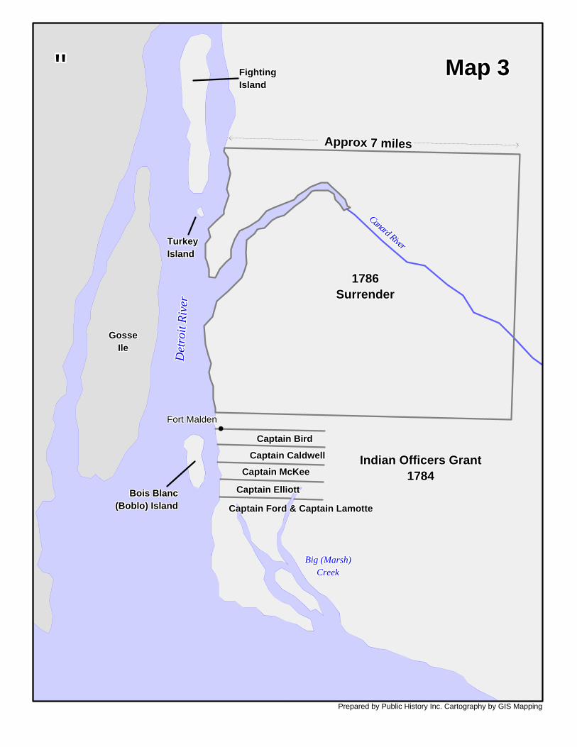
Det
roit
Riv
erD
etro
it R
iver
Det
roit
Riv
erD
etro
it R
iver
Det
roit
Riv
erD
etro
it R
iver
Det
roit
Riv
erD
etro
it R
iver
Det
roit
Riv
erD
etro
it R
iver
Det
roit
Riv
erD
etro
it R
iver
Det
roit
Riv
erD
etro
it R
iver
Det
roit
Riv
erD
etro
it R
iver
Det
roit
Riv
erD
etro
it R
iver
Det
roit
Riv
erD
etro
it R
iver
Det
roit
Riv
erD
etro
it R
iver
Det
roit
Riv
erD
etro
it R
iver
Det
roit
Riv
erD
etro
it R
iver
Det
roit
Riv
erD
etro
it R
iver
Det
roit
Riv
erD
etro
it R
iver
Det
roit
Riv
erD
etro
it R
iver
Det
roit
Riv
erD
etro
it R
iver
Det
roit
Riv
erD
etro
it R
iver
Det
roit
Riv
erD
etro
it R
iver
Det
roit
Riv
erD
etro
it R
iver
Det
roit
Riv
erD
etro
it R
iver
Det
roit
Riv
erD
etro
it R
iver
Det
roit
Riv
erD
etro
it R
iver
Det
roit
Riv
erD
etro
it R
iver
Det
roit
Riv
er
TurkeyTurkeyTurkeyTurkeyTurkeyTurkeyTurkeyTurkeyTurkeyIslandIslandIslandIslandIslandIslandIslandIslandIsland
GosseGosseGosseGosseGosseGosseGosseGosseGosseIleIleIleIleIleIleIleIleIle
Fort MaldenFort MaldenFort MaldenFort MaldenFort MaldenFort MaldenFort MaldenFort MaldenFort Malden
Bois BlancBois BlancBois BlancBois BlancBois BlancBois BlancBois BlancBois BlancBois Blanc(Boblo) Island(Boblo) Island(Boblo) Island(Boblo) Island(Boblo) Island(Boblo) Island(Boblo) Island(Boblo) Island(Boblo) Island
FightingFightingFightingFightingFightingFightingFightingFightingFightingIslandIslandIslandIslandIslandIslandIslandIslandIsland
Captain Ford & Captain LamotteCaptain Ford & Captain LamotteCaptain Ford & Captain LamotteCaptain Ford & Captain LamotteCaptain Ford & Captain LamotteCaptain Ford & Captain LamotteCaptain Ford & Captain LamotteCaptain Ford & Captain LamotteCaptain Ford & Captain Lamotte
Big (Marsh)Big (Marsh)Big (Marsh)Big (Marsh)Big (Marsh)Big (Marsh)Big (Marsh)Big (Marsh)Big (Marsh)Big (Marsh)Big (Marsh)Big (Marsh)Big (Marsh)Big (Marsh)Big (Marsh)Big (Marsh)Big (Marsh)Big (Marsh)Big (Marsh)Big (Marsh)Big (Marsh)Big (Marsh)Big (Marsh)Big (Marsh)Big (Marsh)Big (Marsh)Big (Marsh)Big (Marsh)Big (Marsh)Big (Marsh)Big (Marsh)Big (Marsh)Big (Marsh)Big (Marsh)Big (Marsh)Big (Marsh)Big (Marsh)Big (Marsh)Big (Marsh)Big (Marsh)Big (Marsh)Big (Marsh)Big (Marsh)Big (Marsh)Big (Marsh)Big (Marsh)Big (Marsh)Big (Marsh)Big (Marsh)CreekCreekCreekCreekCreekCreekCreekCreekCreekCreekCreekCreekCreekCreekCreekCreekCreekCreekCreekCreekCreekCreekCreekCreekCreekCreekCreekCreekCreekCreekCreekCreekCreekCreekCreekCreekCreekCreekCreekCreekCreekCreekCreekCreekCreekCreekCreekCreekCreek
Captain McKeeCaptain McKeeCaptain McKeeCaptain McKeeCaptain McKeeCaptain McKeeCaptain McKeeCaptain McKeeCaptain McKee
Captain CaldwellCaptain CaldwellCaptain CaldwellCaptain CaldwellCaptain CaldwellCaptain CaldwellCaptain CaldwellCaptain CaldwellCaptain Caldwell
Captain BirdCaptain BirdCaptain BirdCaptain BirdCaptain BirdCaptain BirdCaptain BirdCaptain BirdCaptain Bird
Captain ElliottCaptain ElliottCaptain ElliottCaptain ElliottCaptain ElliottCaptain ElliottCaptain ElliottCaptain ElliottCaptain Elliott
Indian Officers GrantIndian Officers GrantIndian Officers GrantIndian Officers GrantIndian Officers GrantIndian Officers GrantIndian Officers GrantIndian Officers GrantIndian Officers Grant178417841784178417841784178417841784
178617861786178617861786178617861786SurrenderSurrenderSurrenderSurrenderSurrenderSurrenderSurrenderSurrenderSurrender
Approx 7 milesApprox 7 milesApprox 7 milesApprox 7 milesApprox 7 milesApprox 7 milesApprox 7 milesApprox 7 milesApprox 7 miles
Canard River
Canard River
Canard River
Canard River
Canard River
Canard River
Canard River
Canard River
Canard River
Canard River
Canard River
Canard River
Canard River
Canard River
Canard River
Canard River
Canard River
Canard River
Canard River
Canard River
Canard River
Canard River
Canard River
Canard River
Canard River
Canard River
Canard River
Canard River
Canard River
Canard River
Canard River
Canard River
Canard River
Canard River
Canard River
Canard River
Canard River
Canard River
Canard River
Canard River
Canard River
Canard River
Canard River
Canard River
Canard River
Canard River
Canard River
Canard River
Canard River
Map 3Map 3Map 3Map 3Map 3Map 3Map 3Map 3Map 3
Prepared by Public History Inc. Cartography by GIS Mapping
#################################################
Walpole Island First Nation Boblo Island Inquiry 21
44 Alexander McKee, Detroit, to Sir John Johnson, October 11, 1783, and Captain Bird, Rivers Mouth,to Captain Matthews, October 15, 1783, both in Ernest J. Lajeunesse, The Windsor Border Region: Canada’sSouthernmost Frontier (Toronto: Champlain Society, 1960), Documents G2 and G3, 155–57 (ICC Exhibit 3).
45 List, “Present This Day the Undermentioned Chiefs at the Granting the Land to Mr. Schieffelin,”October 13, 1783, in NA, RG 1, L4, vol. 2, pp. 85–86 (ICC Exhibit 13, document 36).
46 List, “Present This Day the Undermentioned Chiefs at the Granting the Land to Mr. Schieffelin,”October 13, 1783, in NA, RG 1, L4, vol. 2, pp. 85–86 (ICC Exhibit 13, document 36).
47 Indian Deed to Jacob Schieffelin, October 13, 1783, NA, MG 21, Haldimand Papers, Add Mss 21783,ff. 275–76v (ICC Exhibit 13, document 35).
Caldwell and Matthew Elliott, appear to have squatted on particular sites within that block and,
along with Captain Henry Bird and Deputy Indian Agent Alexander McKee, were negotiating with
the local Huron for a “deed” to the block.44 Before they could conclude that transaction, however,
Lieutenant Jacob Schieffelin, Secretary of the Indian Department at Detroit, obtained deeds for the
land from some Ottawa, Chippewa, and Potawatomi Chiefs. Only the deed from the Ottawa was
registered and survives, but there is on record a list of “Chiefs at the granting the Land to Mr.
Schieffelin” which includes the names of six chiefs of the Chippewa Nation and two from the
Potawatomi Nation.45 The “deed” from the Ottawa dated October 13, 1783, was registered “in the
Register of Detroit No. 2 page 283 and 284 by T. Williams, Esq. Recorder and Justice of the
Peace.”46 According to the terms of this deed, seven “Principal Village Chiefs and War Chiefs of the
Ottawa Nation residing near Detroit” granted Schieffelin a “tract or parcel of Land of seven miles
in front and seven miles in depth on the south side [i.e., in British territory] of the Detroit River,
opposite the Isle au Bois blanc.” The grant was made “in consideration of our affection and esteem”
for Schieffelin, and specified no payment in money or goods.47
McKee and Bird wrote letters of complaint as soon as they heard rumours of the transaction,
and, within a week, Chiefs of the local Ottawa, Chippewa, and Huron began a series of four councils
with McKee and others (including the Commanding Officer at Detroit on two of the days) to accuse
Schieffelin of deceit and to plead for the return of the “deed.” The Chippewa were represented at all
the councils, but did not speak. Attending on behalf of the Ottawa at all four councils were some of
the men who had signed Schieffelin’s deed, as well as Egusheway, their principal Chief, who had
not signed the deed. The Huron attended only the last two days of the council: Chief Syndosan spoke
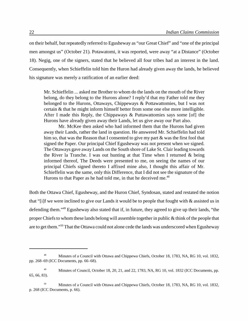
22 Indian Claims Commission
48 Minutes of a Council with Ottawa and Chippewa Chiefs, October 18, 1783, NA, RG 10, vol. 1832,pp. 268–69 (ICC Documents, pp. 66–68).
49 Minutes of Council, October 18, 20, 21, and 22, 1783, NA, RG 10, vol. 1832 (ICC Documents, pp.65, 66, 83).
50 Minutes of a Council with Ottawa and Chippewa Chiefs, October 18, 1783, NA, RG 10, vol. 1832,p. 268 (ICC Documents, p. 66).
on their behalf, but repeatedly referred to Egusheway as “our Great Chief” and “one of the principal
men amongst us” (October 21). Potawatomi, it was reported, were away “at a Distance” (October
18). Negig, one of the signers, stated that he believed all four tribes had an interest in the land.
Consequently, when Schieffelin told him the Huron had already given away the lands, he believed
his signature was merely a ratification of an earlier deed:
Mr. Schieffelin ... asked me Brother to whom do the lands on the mouth of the Riverbelong, do they belong to the Hurons alone? I reply’d that my Father told me theybelonged to the Hurons, Ottaways, Chippeways & Pottawattomies, but I was notcertain & that he might inform himself better from some one else more intelligible.After I made this Reply, the Chippaways & Puttawattomies says some [of] theHurons have already given away their Lands, let us give away our Part also.
Mr. McKee then asked who had informed them that the Hurons had givenaway their Lands, rather the land in question. He answered Mr. Schieffelin had toldhim so, that was the Reason that I consented to give my part & was the first fool thatsigned the Paper. Our principal Chief Egusheway was not present when we signed.The Ottaways gave away Lands on the South shore of Lake St. Clair leading towardsthe River la Tranche. I was out hunting at that Time when I returned & beinginformed thereof, The Deeds were presented to me, on seeing the names of ourprincipal Chiefs signed thereto I affixed mine also, I thought this affair of Mr.Schieffelin was the same, only this Difference, that I did not see the signature of theHurons to that Paper as he had told me, in that he deceived me.48
Both the Ottawa Chief, Egusheway, and the Huron Chief, Syndosan, stated and restated the notion
that “[i]f we were inclined to give our Lands it would be to people that fought with & assisted us in
defending them.”49 Egusheway also stated that if, in future, they agreed to give up their lands, “the
proper Chiefs to whom these lands belong will assemble together in public & think of the people that
are to get them.”50 That the Ottawa could not alone cede the lands was underscored when Egusheway
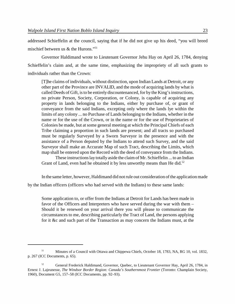
Walpole Island First Nation Boblo Island Inquiry 23
51 Minutes of a Council with Ottawa and Chippewa Chiefs, October 18, 1783, NA, RG 10, vol. 1832,p. 267 (ICC Documents, p. 65).
52 General Frederick Haldimand, Governor, Quebec, to Lieutenant Governor Hay, April 26, 1784, inErnest J. Lajeunesse, The Windsor Border Region: Canada’s Southernmost Frontier (Toronto: Champlain Society,1960), Document G5, 157–58 (ICC Documents, pp. 92–93).
addressed Schieffelin at the council, saying that if he did not give up his deed, “you will breed
mischief between us & the Hurons.”51
Governor Haldimand wrote to Lieutenant Governor Jehu Hay on April 26, 1784, denying
Schieffelin’s claim and, at the same time, emphasizing the impropriety of all such grants to
individuals rather than the Crown:
[T]he claims of individuals, without distinction, upon Indian Lands at Detroit, or anyother part of the Province are INVALID, and the mode of acquiring lands by what iscalled Deeds of Gift, is to be entirely discountenanced, for by the King’s instructions,no private Person, Society, Corporation, or Colony, is capable of acquiring anyproperty in lands belonging to the Indians, either by purchase of, or grant ofconveyance from the said Indians, excepting only where the lands lye within thelimits of any colony ... no Purchase of Lands belonging to the Indians, whether in thename or for the use of the Crown, or in the name or for the use of Proprietaries ofColonies be made, but at some general meeting at which the Principal Chiefs of eachTribe claiming a proportion in such lands are present; and all tracts so purchasedmust be regularly Surveyed by a Sworn Surveyor in the presence and with theassistance of a Person deputed by the Indians to attend such Survey, and the saidSurveyor shall make an Accurate Map of such Tract, describing the Limits, whichmap shall be entered upon the Record with the deed of conveyance from the Indians.
These instructions lay totally aside the claim of Mr. Schieffelin ... to an IndianGrant of Land, even had he obtained it by less unworthy means than He did.52
In the same letter, however, Haldimand did not rule out consideration of the application made
by the Indian officers (officers who had served with the Indians) to these same lands:
Some application to, or offer from the Indians at Detroit for Lands has been made infavor of the Officers and Interpreters who have served during the war with them –Should it be renewed on your arrival there you will please to communicate thecircumstances to me, describing particularly the Tract of Land, the persons applyingfor it &c and such part of the Transaction as may concern the Indians must, at the
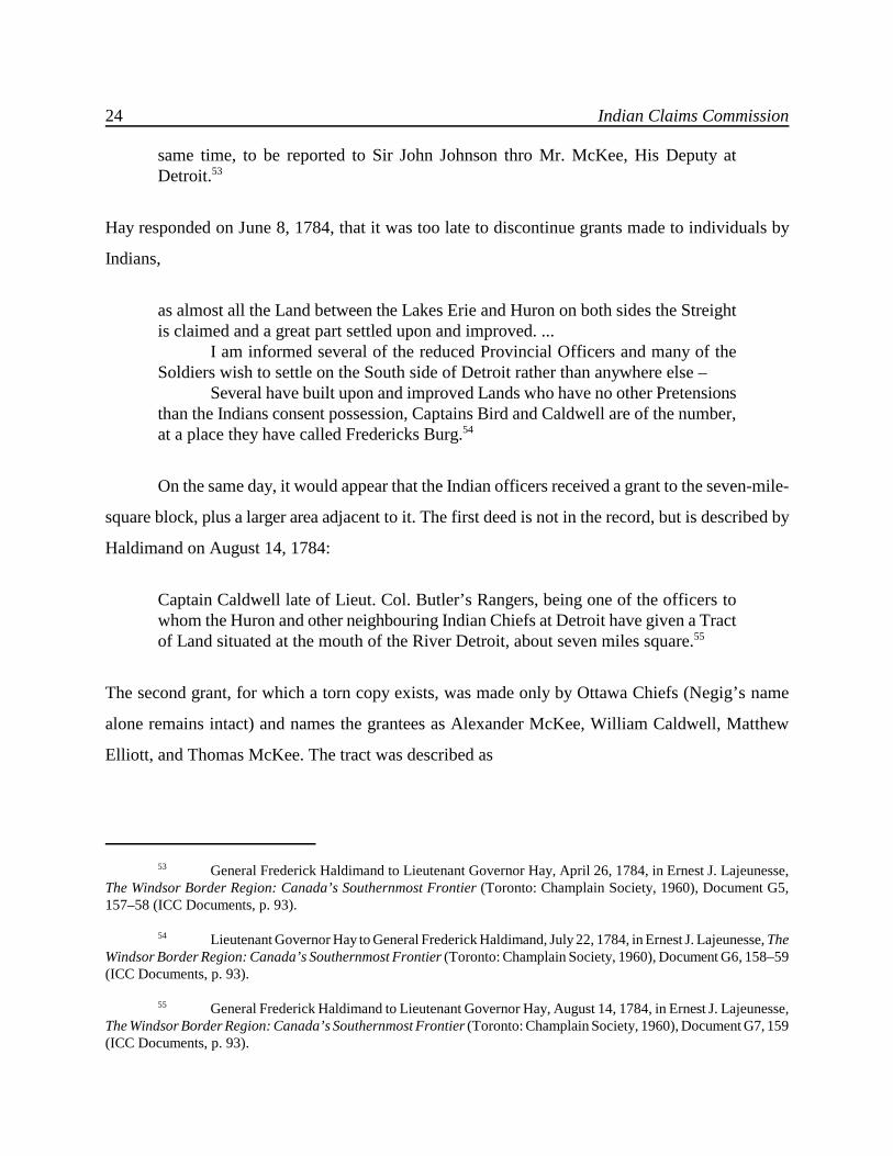
24 Indian Claims Commission
53 General Frederick Haldimand to Lieutenant Governor Hay, April 26, 1784, in Ernest J. Lajeunesse,The Windsor Border Region: Canada’s Southernmost Frontier (Toronto: Champlain Society, 1960), Document G5,157–58 (ICC Documents, p. 93).
54 Lieutenant Governor Hay to General Frederick Haldimand, July 22, 1784, in Ernest J. Lajeunesse, TheWindsor Border Region: Canada’s Southernmost Frontier (Toronto: Champlain Society, 1960), Document G6, 158–59(ICC Documents, p. 93).
55 General Frederick Haldimand to Lieutenant Governor Hay, August 14, 1784, in Ernest J. Lajeunesse,The Windsor Border Region: Canada’s Southernmost Frontier (Toronto: Champlain Society, 1960), Document G7, 159(ICC Documents, p. 93).
same time, to be reported to Sir John Johnson thro Mr. McKee, His Deputy atDetroit.53
Hay responded on June 8, 1784, that it was too late to discontinue grants made to individuals by
Indians,
as almost all the Land between the Lakes Erie and Huron on both sides the Streightis claimed and a great part settled upon and improved. ...
I am informed several of the reduced Provincial Officers and many of theSoldiers wish to settle on the South side of Detroit rather than anywhere else –
Several have built upon and improved Lands who have no other Pretensionsthan the Indians consent possession, Captains Bird and Caldwell are of the number,at a place they have called Fredericks Burg.54
On the same day, it would appear that the Indian officers received a grant to the seven-mile-
square block, plus a larger area adjacent to it. The first deed is not in the record, but is described by
Haldimand on August 14, 1784:
Captain Caldwell late of Lieut. Col. Butler’s Rangers, being one of the officers towhom the Huron and other neighbouring Indian Chiefs at Detroit have given a Tractof Land situated at the mouth of the River Detroit, about seven miles square.55
The second grant, for which a torn copy exists, was made only by Ottawa Chiefs (Negig’s name
alone remains intact) and names the grantees as Alexander McKee, William Caldwell, Matthew
Elliott, and Thomas McKee. The tract was described as
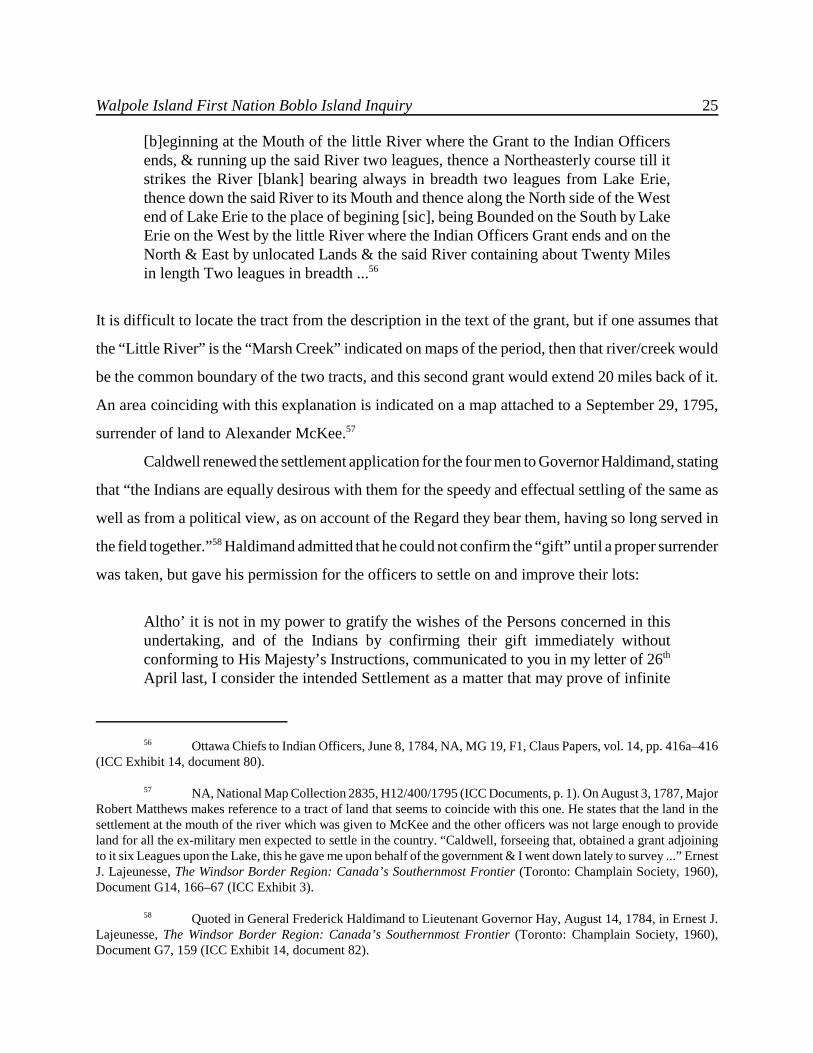
Walpole Island First Nation Boblo Island Inquiry 25
56 Ottawa Chiefs to Indian Officers, June 8, 1784, NA, MG 19, F1, Claus Papers, vol. 14, pp. 416a–416(ICC Exhibit 14, document 80).
57 NA, National Map Collection 2835, H12/400/1795 (ICC Documents, p. 1). On August 3, 1787, MajorRobert Matthews makes reference to a tract of land that seems to coincide with this one. He states that the land in thesettlement at the mouth of the river which was given to McKee and the other officers was not large enough to provideland for all the ex-military men expected to settle in the country. “Caldwell, forseeing that, obtained a grant adjoiningto it six Leagues upon the Lake, this he gave me upon behalf of the government & I went down lately to survey ...” ErnestJ. Lajeunesse, The Windsor Border Region: Canada’s Southernmost Frontier (Toronto: Champlain Society, 1960),Document G14, 166–67 (ICC Exhibit 3).
58 Quoted in General Frederick Haldimand to Lieutenant Governor Hay, August 14, 1784, in Ernest J.Lajeunesse, The Windsor Border Region: Canada’s Southernmost Frontier (Toronto: Champlain Society, 1960),Document G7, 159 (ICC Exhibit 14, document 82).
[b]eginning at the Mouth of the little River where the Grant to the Indian Officersends, & running up the said River two leagues, thence a Northeasterly course till itstrikes the River [blank] bearing always in breadth two leagues from Lake Erie,thence down the said River to its Mouth and thence along the North side of the Westend of Lake Erie to the place of begining [sic], being Bounded on the South by LakeErie on the West by the little River where the Indian Officers Grant ends and on theNorth & East by unlocated Lands & the said River containing about Twenty Milesin length Two leagues in breadth ...56
It is difficult to locate the tract from the description in the text of the grant, but if one assumes that
the “Little River” is the “Marsh Creek” indicated on maps of the period, then that river/creek would
be the common boundary of the two tracts, and this second grant would extend 20 miles back of it.
An area coinciding with this explanation is indicated on a map attached to a September 29, 1795,
surrender of land to Alexander McKee.57
Caldwell renewed the settlement application for the four men to Governor Haldimand, stating
that “the Indians are equally desirous with them for the speedy and effectual settling of the same as
well as from a political view, as on account of the Regard they bear them, having so long served in
the field together.”58 Haldimand admitted that he could not confirm the “gift” until a proper surrender
was taken, but gave his permission for the officers to settle on and improve their lots:
Altho’ it is not in my power to gratify the wishes of the Persons concerned in thisundertaking, and of the Indians by confirming their gift immediately withoutconforming to His Majesty’s Instructions, communicated to you in my letter of 26th
April last, I consider the intended Settlement as a matter that may prove of infinite
26 Indian Claims Commission
59 General Frederick Haldimand to Lieutenant Governor Hay, August 14, 1784, in Ernest J. Lajeunesse,The Windsor Border Region: Canada’s Southernmost Frontier (Toronto: Champlain Society, 1960), Document G7, 159(ICC Exhibit 14, document 82).
60 General Frederick Haldimand to Lieutenant Governor Hay, August 14, 1784, in Ernest J. Lajeunesse,The Windsor Border Region: Canada’s Southernmost Frontier (Toronto: Champlain Society, 1960), Document G7,159–60 (ICC Exhibit 14, document 82).
61 Certificate of Philip Fry, Deputy Surveyor, March 25, 1785, in Ernest J. Lajeunesse, The WindsorBorder Region: Canada’s Southernmost Frontier (Toronto: Champlain Society, 1960), Document G9, 161 (ICC Exhibit12, p. 28).
62 Certificate of Philip Fry, Deputy Surveyor, March 25, 1785, in Ernest J. Lajeunesse, The WindsorBorder Region: Canada’s Southernmost Frontier (Toronto: Champlain Society, 1960), Document G9, 161 (ICC Exhibit12, p. 28).
utility to the Strength and Interest of this Province, and wish to give it everyencouragement in my power ... In the mean time in order to make speedy provisionfor the maintenance of these His Majesty’s Loyal Subjects now dismissed from HisService, I have agreed they shall carry on their Improvements with every diligencein their Power until the Land can be laid out & granted agreeably to the King’sInstructions, and the mode in practice in the lower parts of the Province. You willplease therefore to communicate the same to them, and give such orders as arenecessary for that purpose.59
There is no evidence that the method and form of the Indian officers’ grant differed in any way from
Schieffelin’s, and Haldimand directed McKee to explain to the Indians the steps required to effect
a legal grant of land:
It will be expedient that Mr. McKee should explain to the Indians the nature andintention of the precautions the King has taken to prevent their being iniquitouslydeprived of their Lands, and that they formally, in council, make over to the King, bydeed, the tract in question, for the purpose they wish. Their deed must be transmittedto Sir John Johnson to be properly confirmed by the governor of the Province whenregular grants will be given to the persons who are the proprietors of the Land.60
The lots for the officers and others were surveyed the following year by Deputy Surveyor Philip Fry,
who described them as granted by the “Indians to the Loyalists.”61 As ordered, Fry set out four lots
of six acres each for Bird, Alexander McKee, Caldwell, and Elliott.62 However, in 1789 it was
Walpole Island First Nation Boblo Island Inquiry 27
63 Minutes of the Land Board of Hesse, August 14, 1789, in Third Report of the Bureau of Archives forthe Province of Ontario for 1905 (Toronto: King’s Printer, 1906), 3 (ICC Exhibit 14, document 94).
64 Jacob Schieffelin to Sir John Johnson, October 24, 1783, NA, MG 19, F35, series 1, lot 711, p. 22(ICC Exhibit 14, document 78).
reported that these four officers occupied lots totalling 40 acres in front, “being the Space ----- [sic]
fronting the whole length of the Island of Boisblanc [sic].”63
THE 1786 SURRENDER
Despite his superior’s clearly stated rules and his own admonition to Schieffelin that purchases from
Indians were to be taken only from the proper chiefs, and in public, Deputy Indian Agent Alexander
McKee obtained a surrender in May 1786 from Chippewa and Ottawa Chiefs of both Bois Blanc
Island and a seven-mile-square block across the channel, immediately north of the Indian officers’
grant. (In October 1783, Schieffelin had mentioned that “Mr. McKee has received a Gift from the
Ottawas alone, the Island Commonly called Isle au bois Blânc at the mouth of the River of Detroit,”64
but there is no deed or additional evidence to support that assertion.)
The deed, dated May 15, 1786, confirmed to His Majesty the King the surrender of the island
and the mainland tract, “for and in consideration of the good will, friendship and affection which we
have for Alexander McKee”:
[W]e, the principal village and War Chiefs of the Ottawa & Chipewa Nations ofDetroit, for and in consideration of the good will, friendship and affection which wehave for Alexander McKee, who has served with us against the Enemy during thelate War, have by, & with the consent of the whole of our said Nations ... confirmunto His Majesty George the The [sic] Third, King of Great Britain, France andIreland &c. &c. &c. a certain Tract or parcel of Land situated on the South Side ofDetroit River, beginning at the Line granted on the seventh Day of June, onethousand seven hundred and Eighty four, by the Ottawas & Hurons, to Indianofficers, & running an Easterly Course, along said Line, until it arrives at the End ofSeven English Miles, from thence a northerly course bearing always in breadth SevenEnglish Miles, from the said River Detroit till it strikes the most Northern Branch ofthe River Canard, thence down the said Branch and River Canard, to the mouththereof, & from thence down the River Detroit to the place of beginning. Also an
28 Indian Claims Commission
65 Ottawa and Chippewa Chiefs to the Crown, May 15, 1786, NA, RG 1, L2, vol. B, pp. 245–46 (ICCExhibit 13, document 38). The original of the surrender has not been located. This version is certified to be a true copyby D.W. Smith, Secretary to the Land Board of Hesse. Ernest J. Lajeunesse, The Windsor Border Region: Canada’sSouthernmost Frontier (Toronto: Champlain Society, 1960), Document G13, 165–66 (ICC Documents, Exhibit 3, tab3), also provides a transcript that is almost identical to the one cited above. This surrender appears in Canada’scompilation of Indian Treaties and Surrenders as No. 116, but contains many errors in transcriptions and omits a line.
66 James Morrison, “Identity of Signatories to Treaties No. 116 (1786) and No. 2 (1790),” October 1997,3 (ICC Exhibit 13). Morrison also concludes that the four Chippewa signatories to the 1786 surrender “belonged to theThames River and possibly the Pelee Island/Anderdon regional bands” (4). He submits, however, that although it isrelatively simple to identify the nation of each of the Chiefs, it is difficult to identify the Chief’s particular group or thesubdivisions of the nations involved at the time.
Island in the mouth of the said River Detroit, commonly known by the name of BoisBlanc.65
The deed was witnessed by Thomas Williams, John Clark, and Daniel Field and signed by four
Chippewa Chiefs (Shaboque, Tickcomegosson, Misquecawpowee, and Nayquoscon) and five Ottawa
Chiefs (Egusheway, Pondiac, Kinijiwanoe, Niquelon, and Assinowee). Research commissioned
during this inquiry and conducted jointly on behalf of both parties concluded that none of the
signatories to the 1786 Treaty could be specifically linked to the Walpole Island First Nation.66
Extensive research conducted over a number of years on behalf of both Canada and the First
Nation failed to produce the documents usually associated with a purchase of land from the Indians.
We have seen no instructions or letter of authorization to McKee from his superiors, no minutes of
any council with the Chiefs, nor any report on the proceedings by McKee or other persons attending
the transaction. No payment appears to have been offered or made, and no survey of the lands
contemplated. In fact, the deed is not mentioned in any correspondence for a number of years.
In 1788, Upper Canada was divided into four administrative districts, one of which – Hesse
– included land from Long Point on Lake Erie to Lake St Clair. Initially, judges and sheriffs were
appointed to administer justice in each district, and later District Land Boards were established to
receive and report on applications for land from settlers. McKee was a member of the Land Board
of Hesse from its inception, but it is evident that other members of the Board were, for some months,
ignorant of basic facts about the area entrusted to them. When McKee enlightened them, he
apparently withheld information about his 1786 deed. In June 1789, the Governor, Guy Carleton,
Baron Dorchester, instructed the Board to immediately establish a settlement, to be called George
Walpole Island First Nation Boblo Island Inquiry 29
67 Henry Motz, Secretary (to Lord Dorchester), to the Land Board of Hesse, June 15 (or 14), 1789,referred to in Minutes of the Land Board of August 14, 1789, in Third Report of the Bureau of Archives for the Provinceof Ontario for 1905 (Toronto: King’s Printer, 1906), 2–3 (ICC Exhibit 14, document 94), and in a letter from the LandBoard of Hesse to Dorchester, August 28, 1789, in Third Report of the Bureau of Archives for the Province of Ontariofor 1905 (Toronto: King’s Printer, 1906), 28–29 (ICC Exhibit 14, document 97).
68 Report of John Collins, Deputy Surveyor, District of Nassau, December 6, 1788, in Third Report ofthe Bureau of Archives for the Province of Ontario for 1905 (Toronto: King’s Printer, 1906), 358 (ICC Exhibit 14,document 149).
69 Minutes of the Land Board of Hesse, August 14, 1789, copy in Third Report of the Bureau of Archivesfor the Province of Ontario for 1905 (Toronto: King’s Printer, 1906), 2–3 (ICC Exhibit 14, document 94).
Town, at a location directly opposite Bois Blanc Island67 – a site that had been recommended by
Deputy Surveyor John Collins because its deep channel and safe anchorage would serve both
military and commercial purposes.68 On August 14, 1789, the Board reported that McKee had
informed it that the particular location required for a town site had “never” been surrendered by the
Indians, but was covered by the 1784 grant to the Indian officers:
The Board received and having under consideration the letter from Mr. SecretaryMotz of 15 June, respecting the immediate settlement of George Town have madethe necessary enquiries into the claims of Indians or others being obstacles to theimmediate execution of the plan, learn from Alexander McKee, Esquire, DeputySuperintendent of Indians that the land has never yet been bought from the Indiansfor the use of the crown and that he has no instructions from Sir John Johnson, theSuperintendent-General on that head, but that the Indians have actually divestedthemselves of that land by deed bearing date 7 June 1784 ... in favour of certainofficers and others who served with them during the war.69
The area covered by the May 15, 1786, transaction included land across from, or near to, Bois
Blanc Island, but McKee apparently did not provide his fellow board members with the deed itself
or information that it existed. On August 28, 1789, board members reported that it was impossible
for them to comply with the general instructions for locating settlers because, according to
information given to them by McKee, none of the lands in the District of Hesse had been surrendered
to the Crown:
Our progress on the general printed instructions, handed to us, is now altogetherobstructed by information from Alexander McKee, Esquire, Deputy Superintendentof Indian Affairs, that none of the lands within the limits of the district have been
30 Indian Claims Commission
70 Letter from Land Board of Hesse to Governor Dorchester, August 28, 1789, copy in Third Report ofthe Bureau of Archives for the Province of Ontario for 1905 (Toronto: King’s Printer, 1906), 28 (ICC Exhibit 14,document 97).
71 Copy of letter, Henry Motz, Secretary to Lord Dorchester, to Sir John Johnson, October 5, 1789, inThird Report of the Bureau of Archives for the Province of Ontario for 1905 (Toronto: King’s Printer, 1906), 34 (ICCExhibit 14, document 100).
purchased from the Indians for the Crown, altho they have been parcelled out in largegrants to individuals by the natives, so as to leave none unclaimed from Long pointon Lake Erie to Lake Huron.70
The Governor wrote to Superintendent Sir John Johnson shortly after and clearly stated that previous
purchases of land by or grants to individuals from the Indians were totally void:
[The Indians] should be reminded that all Bargains of Individuals with themrespecting lands are totally void, against the law and can never be acknowledged bythe Crown, that whatever lands are wanted for the settlement of the King’s subjects,the King has made it an invariable rule to apply to the Indians and to satisfy them, forthe cession thereof, afterwards to distribute such lands among his subjects accordingto justice and their deserts, that this law is for the comfort and security of the Indians,as well as for the maintenance of due order among the King’s Subjects, and can neverbe departed from.71
At some point before the end of 1789, McKee submitted his 1786 deed and an accompanying
memorial directly to Governor Dorchester, not to the Land Board. On January 21, 1790, Dorchester’s
secretary forwarded the deed and memorial to the Board for its consideration, while at the same time
stating the Governor’s opinion that the June 1784 deed presented the only equitable claim on lands
in Hesse:
Confined to the information hitherto obtained, His Lordship perceives no ground tosuppose that there is any pretence of equitable claims within any other Indianpurchases or cessions, than that of June 1784 and consequently, that you will findscope for your trust to operate in every other part of the district. You will, therefore,be very particular in your minutes, if you shall see cause in the exercise of yourdiscretion to give hopes to persons that indulge expectations under such IndianGrants, as were not made agreeable to the Royal Instructions, nor have yet had thecountenance or approbation of the government.
Walpole Island First Nation Boblo Island Inquiry 31
72 Copy of letter, Henry Motz, Quebec, to Land Board of Hesse, January 21, 1790, NA, RG 1, L4, vol.2, pp. 88–89 (ICC Documents, pp. 105–6).
73 Minutes of Land Board of Hesse, April 16, 1790, in Third Report of the Bureau of Archives for theProvince of Ontario for 1905 (Toronto: King’s Printer, 1906), 6–7 (ICC Exhibit 14, document 106).
74 Minutes of the Land Board of Hesse, April 21, 1790, copy in Third Report of the Bureau of Archivesfor the Province of Ontario for 1905 (Toronto: King’s Printer, 1906), 8 (ICC Exhibit 14, document 107).
75 Letter from Land Board of Hesse to Land Committee, Quebec, May 6, 1791, in Proceedings of theLand Committee at Quebec, June 3, 1791, NA, RG 1, L1, vol. 18, p. 346 (ICC Documents, p. 201). Emphasis added.
Mr. McKee’s memorial for a tract ceded by the Indians to the Crown on the15th of May 1786, with the deed left here in his behalf, is inclosed for theconsideration and proceedings of the Board, agreeable to their general instructions.72
On April 16, 1790, the Board noted that it had received McKee’s deed and memorial, but
made no comment on it.73 At its next meeting on April 21, it deferred reporting fully on those papers
until after a survey of proposed townships and Crown reserves, but gave conditional consent –
subject to the government’s future ratification of the May 1786 deed – for Surveyor Patrick McNiff
to settle on 200 acres of the land covered by that deed:
That on Consideration of the Petition of Alexander McKee, Esquire, Deputy agentfor Indian affairs, referred to the Board by Mr. Motz’ letter of 21st January – TheBoard is of opinion that ... they cannot report thereon until they have an actual Surveywith the distribution of Townships and reserves ascertained ... – and on Mr. McNiff’sPetition having duly considered the clause of reference and the suggestion frombelow that the whole District (supposing it acquired to the Crown) is open tolocations except the Grants of June 1784, the Board are of opinion that with anexpress knowledge given to the Petitioner of the nature of the intended reserves (hemay be located on the Tract ceded to the Crown by the Deed of 15th May 1786) andon his intimation of consent to the condition of future ratification by the Government,he may take 200 acres not immediately occupied by any other person.74
A copy of McKee’s memorial to Dorchester regarding the May 15, 1786, deed has not been
found and may have been removed from the Land Board’s records by McKee himself (the Board
subsequently reported that “it was withdrawn by Mr. McKee 14 May 1790 and has not been returned
since”).75 The only reference to its wording was made a year later by the Land Board of Hesse, which
32 Indian Claims Commission
76 Letter from Land Board of Hesse to Land Committee, Quebec, May 6, 1791, in Proceedings of theLand Committee at Quebec, June 3, 1791, NA, RG 1, L1, vol. 18, p. 346 (ICC Documents, p. 201).
77 Land Board of Hesse to Alexander McKee, May 14, 1790, in NA, MG 19, F1, Claus Papers, vol. 4,p. 177 (ICC Exhibit 14, document 108). The land covered by McKee’s 1786 grant is often referenced to the RiverCanard, which is some distance north of the 1784 officers’ grant.
78 Copy of a letter from Alexander McKee, Detroit, to Lord Dorchester, Archives of Ontario, CO 42, vol.68, pp. 215–16d (ICC Exhibit 14, document 86).
asserted that McKee had “claimed the Tract at the River Canard for his own use and that of his
friends, and had petitioned for a Grant of it under the Crown.”76
Aside from the question of whether McKee personally had any claim to the tract, the Board
apparently thought the deed was a valid surrender to the Crown. On May 14, 1790, the Board,
worried that McKee’s surrender negotiations were proceeding too slowly to allow for the various
preparations required to receive Loyalists who had already been promised locations, suggested an
immediate survey from Point Pelee to the officers’ grant, because “at present the King has no regular
Grant of any Land unappropriated but a square of seven miles on the River au Canard where they
can be fixed.”77
For his part, McKee indicated to Lord Dorchester as early as May 5, 1790, that he intended
to settle Indian Loyalists on the block covered in his 1786 deed and hoped that the Governor would
approve his application:
[T]here is an Indian Settlement on the River Canard that cannot be removed withoutcreating confusion and perhaps trouble nor will it be consistent with good policy orhumanity to force them to quit. It was my intention by Soliciting these lands (asIndians were already fixed there) to have accommodated several families Likewisewhich to my knowledge from their attachment to Government have been drove fromtheir antient [sic] settlements and who in case of emergency might be depended uponas well as any other Inhabitants, entertaining at the same time an Idea that all thisdescription would be encouraged to live within the protection of the BritishGovernment. My application I understand has been laid before the Land Board at thisplace, which I can only apprehend is no more than to comply with common form inresting with the Governor In Council to act as he may judge proper, it is from himtherefore I am to hope a completion of my desire during my journey among theIndians.78
Walpole Island First Nation Boblo Island Inquiry 33
79 Copy of letter from Alexander McKee to Sir John Johnson, May 25, 1790, NA, RG 1, L4, vol. 3, pp.306–9 (ICC Documents, p. 148).
80 Major Murray, Draught respecting the necessity of making a Reserve of Land at the Huron Church andRiver Canard for the Indians, NA, MG 19, F1, Claus Papers, vol. 4, p. 230 (ICC Exhibit 14, document 84). Note: Thereference to 1784 in this document is clearly an error, since the 1784 officers’ grant was not “in trust for the Crown,”nor was it issued in McKee’s name alone. Instead, it is evident that it refers to the 1786 surrender.
McKee relinquished his interest in or claim to the land in a letter to Sir John Johnson on May
25, 1790, stating that the surrender was made to him in the name of the Crown to ensure that the
Huron themselves were protected from encroachments by others:
That the intention and express purposes of the Deed of Cession to the Crown in 1784[sic] of this Tract, was in trust to me to secure the Indians from encroachments, beingconvinced they would be disturbed in their possessions, which eventually must haveproduced troubles between them and the white Inhabitants, and to evince the truth ofthis, I have no Objections to relinquish any Interest or Claim, to the said Tract, forthe public good.79
In an undated memo (possibly written in the summer of 1790), Major Patrick Murray, the
Commanding Officer at Detroit, echoed McKee’s interpretation of the events surrounding the May
1786 agreement, both as to the trust agreement and the relinquishment of any personal interest of
McKee:
6. That the Intention and Express Purpose of the Indians by their Deed of cession tothe Crown in 1784 [sic] of this tract, was [word crossed out] in trust for Alex McKeeEsq to whose regard for them, they were agreed to intrust their interests that thisDeed being in trust to the Crown for the above purpose only, it cannot be consideredas transferring the Property to the Crown for any other purpose – and accordingly theGovernor in Council only leaves it to the Land Board to Report whether a Grantought to be Given or not to Mr. McKee but certainly never considered the Crown aswilling to accept of or dispose of it for any other Purpose than that designed by theGrantors. [and crossed out?] The Grantee finding it for the public good to relinquishthe benefit intended him by the Deed, rather than applied to purposes contrary to theintention of the trust, and which must have been attended with serious and calamitousConsequences to this Community as a growing Settlement. By so doing leaves it tothe Grantors to dispose of it agreeable to their pleasure.80
As a final word on this matter, the Land Council at Quebec conducted an investigation in
1830 into Indian ownership of lands along the Detroit River, during which the members examined
34 Indian Claims Commission
81 Minutes of the Council at Quebec, March 12, 1830, NA, RG 1, E1, p. 322 (ICC Documents, p. 299).This Council was asked to report to His Excellency, Sir John Colborne, the Lieutenant Governor of Upper Canada, asto how to approach the issue of obtaining the lands reserved in 1790 (the “Huron Reserve”) for their use in settlement.
82 Report of the Council to Lieutenant Governor of Upper Canada John Colborne, regarding the HuronReserve above the Town of Amherstburg, March 12, 1830, NA, RG 1, E1, pp. 323–27 (ICC Documents, pp. 300–4).Emphasis in original. This report included the 1786 surrender as well as correspondence and minutes from the LandBoard at Hesse for the period 1790–91. The Council noted that the evidence indicated that the Huron now had the bestclaim to the lands once belonging to the “Lake Confederacy,” but expressed concern that the Potawatomi and the Huron
the “Papers remaining among the Archives of the Council Office, which are all that they have been
able to find having any important bearing on this case.”81 The Council questioned the Huron and
Potawatomi’s exclusion and McKee’s version of events:
On the 15th May 1786 the Ottawa and Chippewa Nations made a Cession of thisTract to His Majesty. It is remarkable that neither the Pottawatomies nor Hurons areparties to this Cession and that no Notice is taken of their Interest, or of the fact thatthe Huron were occupying a part of the Tract. It is stated in this Deed that the Cessionto His Majesty was made in consideration of the friendship of the Nations forAlexander McKee. The use afterwards attempted to be made of the Deed of Cessionby Captain McKee naturally leads to the conjecture that he was desirous ofextinguishing the claims of the two Nations making it, and that he relied upon beingable to gain the separate assent (or perhaps had gained the assent) of the Hurons, whoas they resided in the District were always accessible. Why the Pottawatimies [sic]were not required to concur does not appear. They perhaps had not any Interest in theLands Ceded.
Having obtained the Deed of Cession made to His Majesty but expressed tobe made upon consideration applys [sic] personally to himself, Captain McKeeaddressed a Memorial to Lord Dorchester applying for the Land thus Cededtransmitting (as it seems) the Deed, and a Sketch of the Tract, which Memorial andPapers were transmitted by His Lordship to the Land Board of Hesse in order thatthey might Report on the same in respect to the legality of Mr. McKee’s claim.
These papers were before the Land Board of Hesse on 16th April 1790, but nodecision was made on this application, which, it is stated in subsequent proceedingsof the Board was withdrawn by Captain McKee.
...Captain McKee states in his Letter [of May 25, 1790, to Sir John Johnson]
“that the intention and express purpose of the Deed of Cession to the Crown in 1784(per 1786) of this Tract, was in Trust to him to Secure the Indians fromencroachments, being convinced they would be disturbed in their possessions, whichmust have produced trouble between them and the White Inhabitants.” – Adeclaration not very easy to be reconciled with the terms of the Deed, or with his ownsubsequent application to Lord Dorchester and to the Land Board. 82
Walpole Island First Nation Boblo Island Inquiry 35
had not been part of the surrender.
83 Lord Dorchester to Sir John Johnson, August 17, 1789, Third Report of the Bureau of Archives forthe Province of Ontario for 1905 (Toronto: King’s Printer, 1906), 32–33 (ICC Exhibit 14, document 110).
THE 1790 TREATY
When Governor Dorchester learned that settlement in the District of Hesse was impeded because the
Indians still owned the land, he immediately began the process to purchase the area. On August 17,
1789, he instructed Superintendent Johnson to direct McKee to take a treaty with the Indians in the
District of Hesse; McKee was to consult with the Land Board to determine the depth (from the river)
of the tract needed for settlement, but McKee was to have authority to use his judgment in the
negotiations to ensure that the Indians were satisfied with the deal:
... and as it shall be found proper to treat for with the Indians consistently with theircomforts, in the judgement of Mr. McKee, whom the board will be directed to settleupon the subject, and it is my desire that they be fully satisfied for what they maycede, and transfer to the Crown in the usual manner.83
Sir John Johnson’s instructions to McKee were not included in the record.
Dorchester also instructed members of the Land Board of Hesse on September 2, 1789, to
work with McKee to determine the depth of the tract, making sure they included within it all lands
currently claimed by settlers:
You will take care that all lands possessed or claimed by individuals under pretenceof private purchases, or grants from Indians, on the side opposite to the port ofDetroit, be comprehended within the limits of this general tract.
But before any part thereof can be granted to individuals, the whole must beceded to the Crown by the Indians. You will therefore call Mr. McKee, the Officerof the Indian Department, to your assistance in deliberating upon this subject, thatyou may have the advantage of His Knowledge of the temper and disposition of theIndians in ascertaining what extent of country may be proper to treat for with them,for the present, consistently with their comfort.
As soon as you have determined upon this point, Mr. McKee, who is toreceive instructions for that purpose from the Superintendent General of Indian
36 Indian Claims Commission
84 Lord Dorchester to the Land Board of Hesse, September 2, 1789, in Third Report of the Bureau ofArchives for the Province of Ontario for1905 (Toronto: King’s Printer, 1906), 30 (ICC Exhibit 14, document 98).
85 Minute of Land Board of Hesse, December 7, 1789, in Third Report of the Bureau of Archives for theProvince of Ontario for1905 (Toronto: King’s Printer, 1906), 6 (ICC Exhibit 14, document 113).
86 See Victor P. Lytwyn, “Historical Research Report on British Policy Regarding the Granting of Islandsin the Context of Bois Blanc (Boblo) Island in the Detroit River,” March 5, 1999, note 137 (ICC Exhibit 14).
87 Alexander McKee, Detroit, to Lord Dorchester, May 5, 1790, PRO, CO 42, vol. 68, pp. 215–16d (ICCExhibit 14, document 86).
88 Minutes of the Land Board of Hesse, May 14, 1790, in Third Report of the Bureau of Archives for theProvince of Ontario for 1905 (Toronto: King’s Printer, 1906), 8 (ICC Exhibit 14, document 109).
affairs, will take the necessary steps to obtain from the Indians their claim andcomplete cession to the Crown.84
On December 7, 1789, the Board recommended that McKee obtain a cession of a tract “bounded by
the waters of the River and Lake St. Clare [sic], Detroit [River] and Lake Erie.”85 No islands within
these bodies of water were mentioned.
The surrender was signed on May 19, 1790, and minutes exist of the council with the Indians
for that day. However, it is evident that the negotiations took place over a number of weeks.86 On
May 5, 1790, for example, McKee reported that he had already had positive discussions about the
purchase with some Indians living at a distance from Detroit and was expecting to meet with the
local Indians as soon as they returned from their winter camps:
I am but a few days returned from a tour into the Indian Country, where I went sometime ago to sound and collect the Indians on the South side of the Lake, concernedin the purchase to be made from them of Land, all those, I have hitherto met with Ifind inclined to comply with the wish of Government. Since my return havedispatched messages to assemble those in the vicinity of this place as soon as arrivedfrom the wintering Grounds which I now expect will be in the course of a few days.87
On May 14, McKee reported to the Board that the purchase would “probably be completed
within a few days”88 and, on May 18, he noted in his journal that some Huron Chiefs had just arrived
Walpole Island First Nation Boblo Island Inquiry 37
89 Extract from the journal of Indian transactions at Detroit kept by Alex McKee, Deputy Agent, May18, 1790, NA, RG 10, vol. 45, p. 23881 (ICC Documents, p. 143).
90 Extract from the journal of Indian transactions at Detroit kept by Alex McKee, Deputy Agent, May19, 1790, NA, RG 10, vol. 45, p. 23881 (ICC Documents, p. 143).
91 James Morrison, “Identity of Signatories to Treaties No. 116 (1786) and No. 2 (1790),” October 1997,3–4 (ICC Exhibit 13).
92 James Morrison, “Identity of Signatories to Treaties No. 116 (1786) and No. 2 (1790),” October 1997,3–4 (ICC Exhibit 13). Morrison notes in his Summary of Findings that, “While it is easy to identify each chief’s Nation(such as Chippewa or Odawa), it is no simple task to identify his particular group or subdivision” (3).
at Detroit to consult with the Lake Indians “respecting the purchase of land.”89 In the same journal,
he wrote that he met with the different nations on May 19 to settle some matters, after which they
held their public meeting and signed the surrender:
19th – Finding that the Nations had not universally agreed in their Opinionsrespecting the Cessions, I had a meeting with them, and settled matters so that theygave their unanimous consent, and desired to have a public meeting in the CouncilChambers that they may then declare their sentiments and Execute the Deed whichwas accordingly done.90
The public meeting was held at Detroit later that day. Attending for the government were
Patrick Murray (the Commanding Officer of the fort), Alexander McKee, 14 named army and navy
officers, as well as an unknown number of officers of the militia, magistrates, and general citizens.
T. Smith, acting clerk, recorded the session. The Indians were represented by 35 Chiefs: eight
Chippewa, eight Ottawa, six Potawatomi, and 13 Huron. Of those, three of the Chippewa Chiefs and
one of the Ottawa Chiefs had also signed the 1786 deed/surrender (no Huron or Potawatomi Chiefs
signed that deed).91 Research conducted for the parties during the course of our inquiry concluded
that the 1790 signatories represented Thames River, Pelee Island/Anderdon, Walpole Island, St Clair
River, and Bear Creek (Sydenham River) regional bands “in what is now southwestern Ontario, as
well as bands in what is now southeastern Michigan.”92
At the council, Egusheway, the principal Chief of the Ottawa, spoke for all the nations and
confirmed that they all agreed to the cession “according to the limits settled between us and you, and
38 Indian Claims Commission
93 Minutes of Council held at Detroit with the Ottawa, Chippewa, Potawatomi, and Huron Nations, May19, 1790, NA, RG 10, vol. 1832, p. 292 (ICC Documents, p. 120).
94 Treaty at Detroit, May 19, 1791, Canada, Indian Treaties and Surrenders (1891; reprint, Toronto:Coles Publishing Co., 1971), vol. 1, no. 2, 3–4 (ICC Documents, pp. 141–42).
95 Minutes of Council held at Detroit with the Ottawa, Chippewa, Potawatomi, and Huron Nations, May19, 1790, NA, RG 10, vol. 1832, pp. 292–93 (ICC Documents, pp. 120–21).
which we are all acquainted with.”93 Within the text of the treaty, the boundaries are described as
follows:
[A] certain Tract of land beginning at the mouth of Catfish Creek, commonly calledRivière au Chaudière on the North Side of Lake Erie being the Western extremity ofa Tract purchased by His said Majesty from the Messesagey Indians in the year OneThousand Seven Hundred and Eighty Four and from thence running Westward alongthe border of Lake Erie and up the Streight [sic] to the mouth of a river known by thename of Channail Ecarté and up the main branch of the said Channail Ecarté to thefirst fork on the south side, then a due east line until it intersects the Rivière à laTranche and up the said Rivière la Tranche to the North-West corner of the saidcession granted to His Majesty in the year One Thousand Seven Hundred and EightyFour, then following the Western boundary of said tract being a due South directionuntil it strikes the mouth of said Catfish Creek, or otherwise Rivière au Chaudièrebeing the first offset.94
There is nothing in the text of the treaty to indicate that the boundary extended into the water or
included any of the islands in Lake Erie, the Detroit River, or Lake St Clair.
Two areas in the ceded tract were reserved for the Indians – a small area near Sandwich and
a larger block in the same place at the River Canard as described in McKee’s 1786 deed. At the May
19, 1790, council, Egusheway directed his explanation of these reserves to the Huron:
Altho we have granted the Land on the other side of the River [from Detroit] to ourFather, we have not forgotten you. We always remembered Brothers, what ourancestors had granted you, that is to say Brothers, from the Church to the RiverJarvais, as well as a piece of Land commencing at the entry of the River Canardextending upwards to the line of the Inhabitants, and which reaches downwardsbeyond the River au Canard to the line of the Inhabitants. Father you have heard whatI have said. I request you Father not to suffer our Brothers the Hurons to be molested.And you Brothers, the Hurons, that you will not molest our Brothers the Inhabitants.95
Walpole Island First Nation Boblo Island Inquiry 39
96 Minutes of Council held at Detroit with the Ottawa, Chippewa, Potawatomi, and Huron Nations, May19, 1790, NA, RG 10, vol. 1832, p. 295 (ICC Documents, p. 123).
97 Treaty at Detroit, May 19, 1791, Canada, Indian Treaties and Surrenders (1891; reprint, Toronto:Coles Publishing Co., 1971), vol. 1, no. 2, 3–4 (ICC Documents, pp. 141–42).
98 Treaty at Detroit, May 19, 1791, Canada, Indian Treaties and Surrenders (1891; reprint, Toronto:Coles Publishing Co., 1971), vol. 1, no. 2, 3–4 (ICC Documents, pp. 141–42).
Major Murray thanked the Indian Nations for the cessions and agreed to the reservation for
the Huron:
The great King and those in office under him, in providing for the advantage of thewhite Inhabitants, seek not to disturb the repose of any of his Indian children; suchparts therefore of the Territory which your ancestors granted the Hurons yourBretheran as you have found requisite for the general Good that they should retainis reserved for their occupation, that they may in common with the other Nationspresent remain under the care of a Father who is equally desirous of promoting theirhappiness and able to protect them from oppression.96
In the text of the surrender, the River Canard location is described as
[r]eserving a Tract beginning at the Indian Officers Land at a small run near the headof the Island of Bois Blanc, and running upwards along the border of the Streight[sic] to the beginning of the French settlement above the head of the Petite Isle auD’Inde, then a due East line, Seven miles and then South so many miles as willintersect another East line run from the mouth of said Run or Gully near the head ofsaid Island of Bois Blanc.97
Bois Blanc and Little Turkey islands were used as reference points to identify the larger of the two
areas reserved from the surrender, but otherwise there is no other mention in the treaty of these or
any other island.
The sale price of the tract was £1,200 Quebec currency, in goods. A list attached to the
surrender shows that the “valuable wares and merchandise” included blankets, strouds, cloth, hats,
knives, rifles, powder, shot, and other items.98 According to McKee’s journal, the Indians received
these items the day after the surrender.
40 Indian Claims Commission
99 Extract from the journal of Indian transactions at Detroit kept by Alexander McKee, Deputy Agent,May 18–22, 1790, NA, RG 10, vol. 45, pp. 13881–82 (ICC Documents, pp. 143–44).
100 Alexander McKee, Detroit, to Land Board of Hesse, May 21, 1790, in Minutes of the Land Board ofHesse for May 21, 1790, in Third Report of the Bureau of Archives for the Province of Ontario for 1905 (Toronto:King’s Printer, 1906), 9.
101 Alexander McKee, Detroit, to Sir John Johnson, May 25, 1790, NA, RG 1, L4, vol. 3, pp. 306–9 (ICCDocuments, pp. 146–49), and Report of Council between Major Murray, Alexander McKee, and Huron Chiefs, May 26,1790, NA, RG 10, vol. 10028 (ICC Documents, pp. 159–60).
May 20th – The Indians being again assembled, they received the Compensation tothe Amount of Twelve hundred pounds Halifax Currency, in the presence of theCommanding Officer & the Officers of the GarrisonMay 21st – The Indians were employed in distributing amongst them the clothing theyreceived yesterdayMay 22nd – I delivered them a Bullock and some Rum to make a Feast as Customaryon such Occasions.99
Alexander McKee reported to the Land Board of Hesse on May 21, 1790, that he had
successfully obtained the cession of land from the Indians according to the limits set in their
resolution of December 7, 1789, except for two areas to be reserved for the Indians, one of which
was “a tract beginning at the Indian officers Land running up the Streight [sic] to the French
settlement and seven miles in depth.”100 McKee insisted that there would have been no surrender if
he had not granted the reserve, and the minutes of a council held with the Huron on May 26, 1790,
seem to bear that out.101 The Board, however, strongly objected to the reserves, especially the larger
one adjacent to the officers’ grant. It was on this particular tract that the board members expected
to establish George Town, as directed, and they relied primarily on McKee’s May 15, 1786, deed to
bolster their arguments:
Had the Board been consulted upon the subject, more especially of the Reserve at theRiver au Canard, Its opinion would have been decidedly against the Derelict of whatwas already vested in the Crown by a Deed from the Indians of 15th May 1786 whichwas before the Board, on a reference from your Lordship of Mr. McKee’s Petitionfor that Tract: not only the respectful caution which the Board would observe in notexceeding the Instructions of your Lordship would have prevented its Consent tosuch Reserves ... first from the Evil precedent to the Indians for counteracting theirown Deeds. ...
Walpole Island First Nation Boblo Island Inquiry 41
102 Land Board of Hesse to Lord Dorchester, Governor, June 1, 1790, NA, RG 1, L4, vol. 2, pp. 310–13(ICC Documents, pp. 156–61).
103 Minutes of the Land Board of Hesse, May 28, 1790, in Third Report of the Bureau of Archives for theProvince of Ontario for 1905 (Toronto: King’s Printer, 1906), 11–12.
104 Minutes of the Land Board of Hesse, May 28, 1790, in Third Report of the Bureau of Archives for theProvince of Ontario for 1905 (Toronto: King’s Printer, 1906), 11–12, and handwritten notes of Major Murray’sdissension (ICC Exhibit 12, pp. 84–85).
... [We] earnestly entreat your Lordship to procure from the Indians an unreservedCession of the Tract at the Riviere au Canard, if that of 1786 shall not be deemedsufficient.102
When this subject was discussed by the Board on May 28, 1790, two members expressed
some concern. Alexander Grant thought “that all information or opinions relative to Indian affairs
should proceed from the Deputy Agent.”103 Major Murray added a written dissent to the minutes,
stressing that the transaction “could not have been accomplished by any means so effectual as those
adopted by the agent for Indian affairs in the late Purchase.”104 Despite his objections, Murray gave
his consent for the Board to forward the entire minutes to Dorchester.
Five months later, in October 1790, board member William Robertson repeated the
sentiments of the majority of the Board to a Land Committee at Quebec, established to consider the
“Causes of the difficulties and impediments which appear to have hitherto obstructed the progress
of Settlement in that important frontier.” The Committee reported Mr Robertson’s testimony:
[H]e considers the portion supposed to be reserved for the use of the Indians lyingwithin the bounds of the tract ceded by the above mentioned Deed of the 19th of Maylast to have been vested in the Crown by a former Deed granted the 15th May 1786.He further says, he by no means conceives the reserve mentioned to be necessary forthe Comfort of the Indians now, more that it was at the time it was ceded in May1786, when the Indians themselves, whose property it then was voluntarily pressedit upon the Indian Agent Mr. McKee, as appears by his Memorial transmitted to theLand Board of Hesse & of which he accepted a Grant in the name & for behalf of theCrown
Mr. Robertson observes that if the Tract (already the Crown’s) were to begiven back to the Indians, it would greatly impede the Settlement of that important
42 Indian Claims Commission
105 Transcript of the Proceedings of the Land Committee at Quebec, October 22, 1790, NA, RG 1, L1,vol. 18, p. 322 (ICC Documents, p. 165).
106 Report of the Land Committee at Quebec, November 29, 1791, in Report of the Department of PublicRecords and Archives of Ontario, 1928 (Toronto: King’s Printer, 1928), p. 176. (A partial copy of this report is in ICCDocuments, pp. 164–213, but the conclusion of the report is not included in that material.)
107 Major Patrick Murray, undated memo, NA, MG 19, F1, Claus Papers, vol. 4, p. 229 (ICC Exhibit 14,document 84).
108 Memorial from Ottawa, Chippewa, and Potawatomi Indians to the Lieutenant Governor of UpperCanada, September 1829, in G.M. Matheson, “Pottawatomies of Walpole Island,” p. 39, NA, RG 10, vol. 121 (ICCExhibit 9).
Frontier by taking away the means of establishing a Fort & Garrisons at the fittestplace ...105
The Land Committee concluded “that although with the Land Board of Hesse, they consider
the tract ceded by the Indians in May, 1786, to be vested in the Crown,” they understood that McKee
thought it necessary to agree to the reserves in order to finalize the cession in May 1790. The
Committee suggested that the Deputy Agent at Detroit be instructed to try to persuade the Huron to
relinquish the land near Amherstburg, in exchange for an equal area “on the northeast shore of the
entrance of Lake St. Claire.”106 The immediate problem with regard to the land for George Town
seems to have been resolved by a clarification of the location of the southern boundary of the Huron
Tract. In an undated memo, Major Murray cited the reasons for the reserves for the Huron and stated:
4. That the tract reserved does not cover the whole land granted front on the Streightbut leaves near a mile between it and the Officers Grant the very spot indicated bythe Engineer as a fit place for a Fort ...107
None of the correspondence relating to this controversy over the Huron Reserve included Bois Blanc
Island, except as a reference point to fix the location of the reserve.
BOIS BLANC (BOBLO) ISLAND AFTER 1790
At various times in the years after the May 19, 1790, surrender there were numerous claims to Bois
Blanc Island by both natives and non-natives. In the early years, Indians coming to collect “presents”
from the Indian Department used Bois Blanc Island as a place to camp and hold their councils.108 In
July 1796, Captain Matthew Elliott was named Superintendent of Indian Affairs at Amherstburg, and
Walpole Island First Nation Boblo Island Inquiry 43
109 Captain Hector McLean, Amherstburg, to Captain James Green, Military Secretary, Headquarters,Quebec, October 28, 1797, in Ernest J. Lajeunesse, The Windsor Border Region: Canada’s Southernmost Frontier(Toronto: Champlain Society, 1960), Document H38, 221 (ICC Exhibit 3).
110 Ernest J. Lajeunesse, The Windsor Border Region: Canada’s Southernmost Frontier (Toronto:Champlain Society, 1960), cxxiv–cxxvi (ICC Exhibit 3).
111 Captain Thomas McKee, Petite Cote, to Lieutenant-Colonel V. Smith, May 3, 1802, and GeorgeIronside, [Amherstburg] to Captain Thomas McKee, Sandwich, April 27, 1802, both in Michigan Pioneer and HistoricalCollections 23 (1895): 11–12 (ICC Exhibit 14, documents 88 and 89).
112 Lieutenant-Colonel V. Smith, Amherstburg, to Major James Green, Military Secretary, Quebec, May19, 1802, in Michigan Pioneer and Historical Collections 23 (1895): 12–13 (ICC Exhibit 14, document 90).
the goods to be distributed to the visiting Indians were stored and distributed from his residence in
the officers’ grant, almost directly across from Bois Blanc Island. Later that year, when the garrison
was moved from Detroit to its new location at Fort Malden (Amherstburg), the Commanding Officer
complained that this arrangement was unsatisfactory. According to him, large numbers of Indians
waited for a number of weeks to receive their presents, and, while waiting, were supplied with rum
by the merchants who had established themselves near the garrison.109 In 1798, Elliott was
summarily dismissed as superintendent and the stores transferred to a room in the garrison.110
This move did not solve the problem. In 1802, the Commanding Officer at the garrison again
reported that the proximity of the visiting Indians’ camp ground on Bois Blanc Island to the rum
merchants in the town of Malden was a problem. He suggested that the Indians should camp on the
mainland in the area of reserved land north of the garrison. Thomas McKee, son of Alexander
McKee, told the officer that his request must be delayed because the island was a camping place
reserved for all the Indians who visited the post:
I am much concerned to delay for a moment the execution of your wishes [to removethe Indians camped on Bois Blanc Island], But knowing that this Island is Indianproperty, and that it was never ceded to the Crown, I think it my duty to apprise youthereof before any attempt is Made to remove them, and to inform you that when theymade the last Session of Lands to the Crown they stated in their speech that thisIsland is expressly reserved for the encampment of their Indian Brethren.111
The Commanding Officer questioned the Indians’ claim to the island, referring to a 1796 plan by
Gother Mann which showed the island as a reservation for the Crown.112 There is nothing on file to
indicate how this problem was resolved.
44 Indian Claims Commission
113 Extract of letter from A.J. Baker, Washington, to Monroe, July 12, 1815, NA, RG 8, vol. 688, p. 176(ICC Documents, p. 269).
114 Extract of letter from Colonel A. Butler, Detroit, to Secretary of War, May 8, 1815, in NA, RG 8, vol.688 (ICC Documents, pp. 249–51).
115 Extract of letter from Mr Monroe, Washington, to Mr Baker, July 10, 1815, in NA, RG 8, vol. 688(ICC Documents, p. 263).
116 Decision of the Commissioners under the Sixth Article of the Treaty of Ghent, June 8, 1822, in Reportof the International Waterways Commission (Ottawa, 1916) (ICC Documents, pp. 284–88). The Treaty of Ghent wassigned on December 24, 1814 (ICC Documents, pp. 242–48).
117 Memorial of Chippewa, Ottawa, and Potawatomi Indians to Lieutenant Governor of Upper Canada,September 1829, in G.M. Matheson, “Pottawatomies of Walpole Island,” NA, RG 10, vol. 121, pp. 46–47 (ICC Exhibit9).
At some time during this period, however, the military built a block house and sergeant’s
command on the island. There are no references to this installation until 1815, when the United
States attempted to claim Bois Blanc Island as its own. With the retreat of General Henry Proctor
in 1812, the United States had taken possession of the island.113 When the War of 1812 ended, the
local U.S. military claimed Bois Blanc Island on the grounds that the U.S. border established in 1783
ran between that island and the mainland. The Americans discounted Major Isaac Brock’s Canadian
claim to the island, based on “his Government having erected a Block House and kept a Sergeant’s
command on the Island some years since,”114 perhaps “before the surrender of Detroit to the United
States under the Treaty of 1783.”115 In 1822, this dispute was resolved in Canada’s favour when the
commissioners appointed according to the 1814 Treaty of Ghent established the U.S. border west
of Bois Blanc Island.116
In 1829, Ottawa, Chippewa, and Potawatomi Chiefs at Amherstburg sent a memorial to the
Lieutenant Governor of Upper Canada, responding to some previous claims the Huron had made to
sole ownership of the Huron Reserve and other areas associated with the surrender of May 19, 1790.
In this memorial, the Chiefs stated that although they had been in the United States since the
surrender, they did not “divest” themselves “of the right & possession of the disputed tract,” which
they claimed to have used as a camping ground on their visits. The Chiefs declared that they were
about to leave the United States and wanted to “exchange” their “shares on this Indian Reserve [the
Huron Reserve] & Fighting Island, for wild lands on Lake Huron.”117 Bois Blanc Island was not
mentioned specifically in this memorial.
Walpole Island First Nation Boblo Island Inquiry 45
118 Canadian Emigrant, January 5, 1836, quoted in David P. Botsford, “The History of Bois BlancIsland,” Ontario History 47 (summer 1955): 137 (ICC Exhibit 5).
119 Dennis Carter-Edwards, “Fort Malden: A Structural Narrative History, 1796–1776,” Parks CanadaManuscript Report No. 401, 1980, p. 273 (ICC Exhibit 4).
120 Petition of James Hackett to Bond Head, June 12, 1837, and Order of the Executive Council, July 20,1837, NA, RG 1, L 13, vol. 239, pp. 150–50B (ICC Documents, pp. 322–26).
121 David P. Botsford, “The History of Bois Blanc Island,” Ontario History 47 (summer 1955): 138 (ICCExhibit 5).
122 Dennis Carter-Edwards, “Fort Malden: A Structural Narrative History, 1796–1776,” Parks CanadaManuscript Report No. 401, 1980, pp. 273–74 (ICC Exhibit 4).
123 An Act respecting the Ordnance and Admiralty Lands transferred to the Province, June 19, 1856, 22Vict., c. 24, pp. 293 and 297 (ICC Documents, pp. 349 and 353).
124 Foley & Daley Associates, “Walpole Island First Nation Claim to the Island of Bois Blanc (Bob Lo),”revised September 1993, p. 56 (ICC Exhibit 6), and David P. Botsford, “The History of Bois Blanc Island,” OntarioHistory 47 (summer 1955): 138 (ICC Exhibit 5).
In 1836, the government constructed a lighthouse and a cottage on the south end of Bois
Blanc Island and installed James Hackett as its keeper.118 Hackett originally had a residence,
outbuildings, and about 20 acres as part of the lighthouse establishment,119 to which was added about
15 acres in July 1837.120 He and his family were forced to leave for a short period during the 1837
Rebellion, when Patriot forces from Detroit occupied the island.121
The military buildings on the island were manned until the regular forces were withdrawn
from Fort Malden in 1851. Some of the enrolled pensioners who acted as a reserve force at the fort
also took up leases on the island (among them James Cousins, with 20 acres on the northeast corner
of the island; John Bonnett, occupying the blockhouse on the western side; and Thomas Yennan,
with 25 acres under cultivation at another location).122 In June 1856, An Act respecting the Ordnance
and Admiralty Lands transferred to the Province included the 212 acres of Bois Blanc Island as
Class B lands – military properties to be retained by the provincial government for the defence of
the province.123 Various people held leases on the island until December 1866, when it was
purchased by the local Member of Parliament, Arthur Rankin. Property on the island changed hands
a number of times before it was eventually purchased by an American company in 1900 for the
establishment of a dance pavilion and amusement park.124
46 Indian Claims Commission
125 Petition Relative to the Islands and Lands claimed by the Walpole Island Indians in the WesternDistrict, August 22, 1856, NA, RG 10, vol. 398 (ICC Documents, p. 356).
126 Petition Relative to the Islands and Lands claimed by the Walpole Island Indians in the WesternDistrict, August 22, 1856, NA, RG 10, vol. 398 (ICC Documents, pp. 356–60).
Throughout this period, various Indian groups in the area also made claims to Bois Blanc
Island. In August 1856, a Chippewa Chief, Peto-e-kee-shick, was one of the delegates from Walpole
Island who travelled to England and presented a petition to Queen Victoria. Among the grievances
set out in their petition was a claim for Bois Blanc Island:
The Island near Amherstburg was not sold, it belongs to the Indians, the ObjibewayIndians, of whom Peto-e-kee-shick is a chief. The soldiers of the White Governmentare now on this Island, some of them have built homes there. The Chief wishes to sellthis Island now, as the people have cut so many trees down.125
Witnesses to this petition declared that they had made inquiries into the various claims, including
that “the Small Island on Detroit River called Bois blanc Island, Wee-gov-bee-min-ishang, has been
occupied by the military without any settlement being made for it with the Indians who are the
owners,” and were “unable to ascertain any facts inconsistent with the above statement of Peto-e-
kee-shick.”126 There was no response to the above petition.
In that same time period, the Chippewa of Point Pelee also claimed Bois Blanc Island. In
their 1858 report regarding the claims of the Huron to the reserve in Anderdon, Fighting Island, and
Turkey Island, Commissioners Pennefather, Talfourd, and Worthington reported that the island had
never been surrendered:
Bois Blanc Island opposite the Town of Amherstburg is not claimed by this Tribe[Hurons], has never been surrendered to the Crown but is designated as Ordnanceland, the Chippewas of Point Pelee have however asserted their right to it. A searchin the old Records of the Indian Office has shown us that this Island was formerlyconsidered as Indian property held in common by the Wyandots, Chippewas, Ottawasand Pottawatomies, as a Camping Ground and place of Council. The Ordnancevesting Act having placed it in the same category as Fighting Island, it will be forYour Excellency to decide what compensation may be due to the Tribes remaining
Walpole Island First Nation Boblo Island Inquiry 47
127 Extract from report of Commissioners Pennefather, Talfourd, and Worthington, 1858, in G.M.Matheson, “Pottawatomies of Walpole Island,” NA, RG 10, vol. 121, p. 148 (ICC Exhibit 9).
128 Memorial of Chippewa, Ottawa, and Potawatomi Nations of Walpole Island, August 4,1867, NA, RG10, vol. 325, pp. 21796–71 (ICC Documents, pp. 448–50).
129 Memorial of Chippewa, Ottawa ,and Potawatomi Nations of Walpole Island, August 4,1867, NA, RG10, vol. 325, pp. 217969–70 (ICC Documents, pp. 448–49).
on the English side of the River, if it taken possession of by the Government underthis Title.127
Again, there is no correspondence in response to this statement.
On August 5, 1867, the Ottawa, Chippewa, and Potawatomi of Walpole Island petitioned the
Governor General with claims to the Huron Reserve in Anderdon, Fighting Island, and Bois Blanc
Island. They declared themselves to be descendants of the Ottawa, Chippewa, and Potawatomi “who
formerly displayed loyalty to the British Government ... [who were] the rightful proprietors of the
Peninsula between Lakes Huron, St. Clair and Erie.”128 According to them, the Chippewa had moved
to other tracts of land along the St Clair River, while the Ottawa and Potawatomi had gone back to
the United States, where they had wandered and hunted throughout the unsettled territory and the
state of Michigan. They had done so without “any intention of forever abandoning the Land and the
Islands reserve by them [along the Detroit River],” but, since about 1837, they had all returned and
settled at Walpole Island.129 The petitioners recounted that they had periodically consulted the local
Indian agent (who told them that no action could be taken because of the length of time intervening),
and that they had held two councils with the Huron, where they unsuccessfully tried to negotiate
shared ownership. According to the petition, the islands, including Bois Blanc, belonged to the
Ottawa, Chippewa, and Potawatomi alone and they wanted them to be disposed of for their benefit:
9. That the Islands respectively called Fighting and Bois Blanc both in the RiverDetroit and vicinity of the said Huron Reservation – but not wholly in front of thatReserve were owned and held in common at an earlier date by the said Chippeway,Potawatomy and Ottawa Nations only and in consequence were not included in theTerritory so ceded.
[No.10 protests Huron surrender of Fighting Island.]
48 Indian Claims Commission
130 Memorial of Chippewa, Ottawa, and Potawatomi Nations of Walpole Island, August 4,1867, NA, RG10, vol. 325, pp. 217972 (ICC Documents, p. 451).
131 William L. Fisher to Superintendent General of Indian Affairs, November 14, 1867, NA, RG 10, vol.325, p. 217965 (ICC Documents, p. 457).
132 Notation on file cover, author not identified, no date (c. November 16, 1867), NA, RG 10, vol. 325,C446, No. 221, p. 217968 (ICC Documents, pp. 446–47).
11. That the Bois Blanc Island which was for many years used for landing andcamping purposes and place of Council have never been surrendered and as it titlebelongs to your Memorialists they now come to offer to surrender it to be disposedof for their own benefit.130
William Fisher, a Walpole Island band member and interpreter, forwarded the petition on
November 14, 1867, adding: “My people have repeatedly told me that the Bois Blanc Island had
never been surrendered and thus cannot be sold without the proprietors are first consulted.”131 A
notation on the file cover for the above correspondence indicates that research had found the May
15, 1786, deed and, according to the unnamed author, this document extinguished rights to the island
for the Ottawa and Chippewa, but not the Potawatomi or Huron:
Bois Blanc Island in the Detroit River is not embraced by the Surrender made by theIndians in the year 1793 [sic] of the Territory bordering on Lake Erie and the DetroitRiver & it would seem that in consequence of a Block House having been at one timeerected upon it included in the Schedule of lands attached to the Ordnance VestingAct and it is stated in the Special Commrs Report of 1858 that it never wassurrendered to the Crown. I find however upon examining an old Surrender dated 15May 1786 it was included therein but no Payments in consideration therefore weredescribed. The only parties to the surrender made in 1786 with the Ottawas &Chippewas & having accordingly the claims of the Pottawatomies & Hurons theretounextinguished and as valid now as at any former time. This claim or right extendsalso to the Reserve Seven miles Square set apart and preserved to the Indians by theTreaty of May 1790 which returned Reserve now constitutes the Township ofAnderdon.132
In 1870, the Walpole Island Indians again petitioned the government regarding these lands.
This time, Senator Walter McCrea forwarded their petition with his strong endorsement as to its
validity:
Walpole Island First Nation Boblo Island Inquiry 49
133 Copy of letter from W. McCrea to Joseph Howe, Secretary of State for the Provinces andSuperintendent of Indian Affairs, March 3, 1870, in NA, RG 10, vol. 10028 (ICC Documents, pp. 487–90). Thememorial (the wording of which is almost identical to the one submitted in 1867) is dated February 8, 1870, and is inNA, RG 10, vol. 398, pp. 256–61 (ICC Documents, pp. 470–86).
134 Copy of Letterbook entry, Joseph Howe to Hon. Walter McCrea, Senator, April 4, 1870, in G.M.Matheson, “Pottawatomies of Walpole Island,” NA, RG 10, vol. 121, pp. 158–64 (ICC Documents, pp. 491–97).
135 Abstract from report of Deputy Superintendent General’s Report, March 9, 1869, in G.M. Matheson,“Pottawatomies of Walpole Island,” NA, RG 10, vol. 121, p. 159 (ICC Documents, p. 492).
Then as to Bois Blanc Island, there is no doubt it never was ceded by the Indians andeven if the Government sold it to Mr. Rankin as Ordnance Lands, no longer usefulfor such purposes I presume, they should first have extinguished the Indian claimsto it. I should say rather that when the Government found it no longer required forOrdnance purposes, they should have surrendered it to the Indians and then treatedwith them for the purchase thereof.
...
... I believe they have a just and fair claim to a reasonable compensation forthe surrender of their claims to the four Islands mentioned in the Memorial, and asthe Government has chosen to grant these Islands, it is to the Government they havea right to look for that compensation and not to the grantees, who may, or may not,be responsible parties at all.133
Joseph Howe, the Secretary of State for the Provinces and head of the Indian Department,
responded by sending the Senator abstracts from various reports on the Walpole Island claims, “from
the concluding portions of which you will observe that the matter was disposed of by my predecessor
and that it was to be regarded as finally settled.”134 Among the abstracts in Howe’s letter was one
from a March 1869 report by the Deputy Superintendent General of Indian Affairs which concluded
that the islands in the Detroit River were not included in the May 19, 1790, cession, but “[u]nder date
of 15 May 1786, Bois Blanc Island in the River Detroit together with a tract on the Mainland seven
miles square was surrendered to the Crown by the Chippewas & Ottawas.”135
In an interview with departmental officials late in 1895, Chief Robert Caldwell claimed Bois
Blanc Island, among others. He was told that it was surrendered by the Ottawa and Chippewa on
50 Indian Claims Commission
136 Memo [Hayter Reed, Deputy Superintendent General of Indian Affairs], January 3, 1896, NA, RG 10,vol. 2043, file 8996, pt 3 (ICC Documents, pp. 574–83).
137 Copy of Memorial of Chippewa, Ottawa, and Potawatomi Indians of Walpole Island, May 30, 1899,NA, RG 10, vol. 787, pp. 12–20 (ICC Documents, pp. 619–30).
May 15, 1786.136 Then in May 1899 a nearly identical version of the1870 petition mentioned above
was sent to the Governor General, to which there was no response.137

PART III
ISSUES
At a pre-hearing conference held on January 28, 1999, the parties agreed to seven main issues.
Before outlining them, we note that the disposition of the first issue addresses some of the questions
raised in the other issues. We have attempted to deal with the various points raised by counsel for
each party where appropriate in our analysis. As such, we did not find it necessary to deal with every
issue raised.
The issues agreed to by the claimant and Canada were as follows:
1 Does the Surrender of May 15, 1786, contravene the provisions of the Royal Proclamation of 1763?
2 (a) Were the Chiefs and principal men of the Walpole Island First Nation signatoriesto the alleged surrender of May 15, 1786?
(b) If they were not, does this make the surrender invalid with respect to the WalpoleIsland First Nation?
3 Was there consideration for the transfer?
4 If there was not, does this render the surrender invalid?
5 (a) Did the Crown and/or Indians regard the surrender of 1786 as invalid when theyentered into the surrender of 1790?
(b) If so, what is the effect of the 1790 surrender on the alleged surrender of 1786?
6 Is the Crown estopped from relying upon the surrender of 1786?
7 Did the Crown breach its fiduciary obligations in obtaining the surrender?
We will address these issues in the following section of the report.

138 Submission on Behalf of the Walpole Island First Nation, March 12, 1999, paragraph 4.
PART IV
ANALYSIS
On May 15, 1786, Alexander McKee, the Deputy Superintendent of Indian Affairs, proceeded to get
a surrender of lands from certain chiefs of the Ottawa and Chippewa Nations. These lands extended
for seven miles, including the mouth of the Detroit River as well as Bois Blanc Island. Much of our
analysis turns on the question of whether this surrender was legally valid.
The question to determine first is whether the 1786 surrender conformed to the protocol of
the Royal Proclamation of 1763. If it did, the surrender is valid. If it did not, we must determine
whether this unconformity renders it invalid.
ISSUE 1 Does the Surrender of May 15, 1786, Contravene the Provisions of the Royal
Proclamation of 1763?
The Walpole Island First Nation argues that the 1786 Surrender was invalid for three main reasons:
1 The surrender was contrary to the Royal Proclamation of 1763 because the lands were not“purchased.”
2 The true intent of those First Nations who signed the 1786 Surrender was to reserve orpreserve those lands for the use and benefit of First Nations.
3 The 1790 Surrender was intended to supersede and replace the 1786 Surrender.138
Before we can address the first of the claimants’ submissions, we must address a preliminary
argument raised by Canada to the effect that the Royal Proclamation of 1763 does not apply within
the territory at issue.
Applicability of the Royal Proclamation
The Walpole Island First Nation argues that as early as July 9, 1754, the private purchases of Indian
lands for “small and trifling considerations” were discussed by the British Crown, and that, to avoid
54 Indian Claims Commission
139 Submission on Behalf of the Walpole Island First Nation, March 12, 1999, paragraph 13.
140 Submission on Behalf of the Walpole Island First Nation, March 12, 1999, paragraph 15.
141 Submission on Behalf of the Government of Canada, March 22, 1999, paragraphs 3 and 4.
142 Submission on Behalf of the Government of Canada, March 22, 1999, paragraph 33. Emphasis added.
143 See Ontario (A.G.) v. Bear Island Foundation, [1989] 2 CNLR 73 at 77–78.
144 Royal Proclamation, October 7, 1763 (ICC Documents, pp. 25–32).
145 The Royal Charter incorporating the Hudson’s Bay Company, A.D. 1670, in Bernard W. Funston andEugene Meehan, eds., Canadian Constitutional Documents Consolidated (Scarborough, Ont.: Carswell Publishing,1994).
uneasiness, it was recommended that all such purchases in future should be void.139 The First Nation
points to the Royal Proclamation of 1763, which required that the disposition or purchase of Indian
lands take place at a public or general meeting.140
Canada’s position, by contrast, is that the Royal Proclamation did not apply in the
circumstances, or, alternatively, that it did not apply geographically to Boblo Island.141 This argument
is reflected in the following submission:
It is Canada’s submission that the Royal Prerogative [sic] does not apply to BobloIsland because it was not within those lands where it was thought proper to allowsettlement. The claimant provides no evidence that the Royal Proclamation appliesto Boblo Island. In Bear Island Foundation v. A.G. Ontario et al (1989) 58 DLR (4th)117 (Ont. C.A.), the Court held at 133 that:
It is at least questionable whether these provisions affected theTemagami lands since they may not have been “within those parts ofour Colony where We have thought proper to allow settlement.”142
In essence, Canada, relying on the case of Ontario (A.G.) v. Bear Island Foundation,143 argues that,
as Boblo Island was not intended for settlement, the Royal Proclamation did not apply.
In our view, Canada’s submission interprets the Bear Island decision somewhat out of
context. The Royal Proclamation excluded the Hudson’s Bay Company territory,144 which was
bounded by the “height of land” as its northern extremity.145 One of the issues in Bear Island at trial
was whether the Royal Proclamation applied to the geographical area north of the height of land
Walpole Island First Nation Boblo Island Inquiry 55
146 Ontario (A.G.) v. Bear Island Foundation, [1989] 2 CNLR 73 at 77–78.
147 Royal Proclamation, October 7, 1763 (ICC Documents, pp. 25–32).
148 As held most recently in the Chippewas of Sarnia Band v. Canada (Attorney General), [1999] OJ No.1406 at 188 (Gen. Div.).
149 Douglas Leighton, The Historical Development of the Walpole Island Community, Occasional PaperNo. 22 (Wallaceburg: Walpole Island Research Guide, 1986), 15–16.
where the territory at issue in that case was located, an issue the Ontario Court of Appeal found
unnecessary to address in light of its overall findings. It is noteworthy, however, that the trial judge,
whose findings were not interfered with in this respect, found as a fact that the Royal Proclamation
applied to the lands south of the height of land.146 The passage cited by Canada from the Ontario
Court of Appeal in Bear Island, then, is obiter, and was, in any event, made in the context of
considering the territorial applicability of the Royal Proclamation in northern, not southern, Ontario.
However, the suggestion that Canada asks us to accept is that surrenders would be required
under the terms of the Proclamation only in lands where settlement was to occur. We do not agree.
The Proclamation applied to the Indian Territory, a territory which was defined geographically
within the Proclamation in terms that clearly included southern Ontario.147 Lands in southwestern
Ontario have been held to be subject to the Royal Proclamation.148 The Proclamation applied
wherever Indian lands were to be obtained by the Crown. The Detroit River/Lake St Clair region,
where this claim arises, unquestionably fell within the vast area reserved by the Royal Proclamation
for Indian use.149
As noted in Part II, even before 1763, the British had recognized that the purchase of Indian
lands had to be regulated to prevent the increasing loss of Indian allies to the French. Representatives
of the British Colonies met in a general council at Albany, New York, in 1754 to discuss these and
other problems that had developed with the Indians. One of the causes was identified to be the
purchase of lands from Indians by individuals for “trifling consideration”:
That purchases of lands from the Indians by private persons for small triflingconsiderations, have been the cause of great uneasiness and discontents, and if theIndians are not in fact imposed on and injured, yet they are apt to think that they havebeen and indeed they appear not fit to be intrusted at large with the sale of their own
56 Indian Claims Commission
150 Report to Council, July 9, 1754, in E.B. O’Callaghan, ed., Documents Relative to the Colonial Historyof the State of New-York, 15 vols. (Albany, NY: Weed, Parsons & Co., 1856–87), 6: 888 (ICC Documents, p. 8).Emphasis added.
151 Submission on Behalf of the Walpole Island First Nation, March 12, 1999, paragraph 16, citing VictorP. Lytwyn, “Historical Research Report on British Policy Regarding the Granting of Islands in the Context of Bois Blanc(Boblo) Island in the Detroit River,” pp. 4, 13, 15.
lands, and the Laws of some of the Colonies which make such sales void, unless theallowance of the Governt be first obtained, seem to be well founded. ...
That all future purchase of lands from the Indians be void unless made by theGovernt where such lands lye, and from the Indians in a body in their publiccouncils.150
On October 7, 1763, King George III issued the Royal Proclamation to formalize all previous
instructions and policies and to establish some rules for the management of the Indian territory. The
Walpole First Nation submits that the requirements of the Royal Proclamation were conveyed
specifically to the ancestors of the First Nation in September 1765 at a meeting at the “crooked
place” (Niagara) between Sir William Johnson, the Superintendent General of Indian Affairs, and
these ancestors, as set out in a report prepared by Dr Victor Lytwyn.151
We do not find that the Lytwyn report provides sufficient information to reach the conclusion
that the provisions of the Royal Proclamation were communicated to the ancestors of the First
Nation. However, for applicability of the Royal Proclamation, it is not necessary to find that actual
notice of its contents was provided. As we will discuss further in our report, the policy was binding
on the Crown’s representatives, and the valid surrender of lands required compliance with its
provisions. As the trial judge held in the Chippewas of Sarnia Band v. Canada:
This private sale of unsurrendered Indian land was the very thing prohibited then andnow by the common law of Indian title, confirmed by the Royal Proclamation of1763 and by recent judgments of the Supreme Court of Canada. The overwhelmingweight of judicial authority including the Court of Appeal judgments in Shawanagaand Kettle and Stony Point establishes that the common law surrender requirementsreflected in the Royal Proclamation were fully in force at all material times. Sale ofIndian land was strictly prohibited unless purchased by the Crown, in the name of theCrown, at some public meeting of the Indians assembled for that purpose by theGovernor or his equivalent ... Quite apart from the Royal Proclamation these
Walpole Island First Nation Boblo Island Inquiry 57
152 Chippewas of Sarnia Band v. Canada (Attorney General), [1999] OJ No. 1406 at 188 (Gen. Div.).
153 Royal Proclamation, October 7, 1763 (ICC Documents, pp. 29–31). Emphasis added.
elements of Indian title at common law were reflected in the invariable Crownpractice of the times by the actions and statements and legal opinions of IndianDepartment officials and governors and law officers of the Crown including theAttorney General ...152
We therefore reject the Crown’s submission that the Royal Proclamation of 1763 did not apply in
the circumstances.
Requirements of the Royal Proclamation
According to the Royal Proclamation, when lands were required by the Crown, certain preconditions
had to be met. As the Proclamation itself stated:
We do hereby strictly forbid, on Pain of Our Displeasure, all Our loving Subjectsfrom making any Purchases or Settlements whatever, or taking Possession of any ofthe Lands above reserved, without Our especial Leave and Licence for the Purposefirst obtained.
We do, with the Advice of Our Privy Council, strictly enjoin and require, thatno private Person do presume to make any Purchase from the said Indians of anyLands reserved to the said Indians, within those Parts of Our Colonies where Wehave thought proper to allow Settlement; but that if, at any Time, any of the saidIndians should be inclined to dispose of the said Lands, the same shall be purchasedonly for Us, in Our Name, at some public Meeting or Assembly of the said Indiansto be held for that Purpose by the Governor or Commander in Chief of our Colonies...153
Instructions sent to Governor James Murray in December 1763 confirmed that
Whereas We have, by Our Proclamation dated the seventh day of October in theThird year of Our Reign, strictly forbid, on pain of Our Displeasure, all Our Subjectsfrom making any Purchases of Settlements whatever, or taking Possession of any ofthe Lands reserved to the several Nations of Indians, with whom We are connected,and who live under Our Protection, without Our especial Leave for that Purpose firstobtained; It is Our express Will and Pleasure, that you take the most effectual Care
58 Indian Claims Commission
154 Instructions to James Murray, December 7, 1763, in Third Report of the Bureau of Archives for theProvince of Ontario for1905 (Toronto: King’s Printer, 1906), lx (ICC Exhibit 14, document 18). Emphasis added.
155 Speech dated January 20, 1764, by Sir William Johnson to the Six Nations, in James Sullivan et al.,eds., The Papers of Sir William Johnson Papers, 14 vols. (Albany, NY, 1921–65), 11: 30–31 (ICC Exhibit 14, document20). Emphasis added.
156 General Gage, New York, to Commander at Detroit, April 8, 1771, in Ernest J. Lajeunesse, TheWindsor Border Region: Canada’s Southernmost Frontier (Toronto: Champlain Society, 1960), Document C17, 64–65(ICC Exhibit 12, pp. 2–3). Emphasis added.
that Our Royal Directions herein be punctually complied with, and that the Tradewith such of the said Indians as depend upon your Government be carried on in theManner and under the Regulations prescribed in Our said Proclamation.154
In January 1764, William Johnson informed the Six Nations of the land provisions of the
Royal Proclamation:
You need be under no Apprehensions concerning your Lands or Possessions afterwhat I have lately informed you of his Majestys Royal Proclamation, commandingthat no Lands whatsoever should be taken from you, nor any Purchase attempted tobe made, but with your Consents in a public Meeting of each Nation; and as I amgetting Copies of that Proclamation printed, so soon as they are ready, I shall sendone to your Nation (as well as to the rest) for your satisfaction on that head.155
The binding nature of the Proclamation is apparent from the historical correspondence placed
before us. In April 1771, General Thomas Gage, Commander-in-Chief of the British forces at New
York, wrote a letter to the Commander at Detroit stating that all previous grants, whether to the
French or the British, were to be voided where they had been made without the King’s permission
and authority:
... I am to explain to you that the King has not invested any Person whatever with thepower of granting Lands in America, except to his Governors, within the limits oftheir respective Provinces & under certain forms and restrictions, and where anyPurchase is made of the Indians tho’ within the limits of the Provinces they are notvalid, unless permission is given so to do & the purchase made in presence of theGovernor & His Majesty’s Superintendent of Indian Affairs. From hence you willknow the power of granting Lands at Detroit remains solely in the King & that noPurchase can be made of the Indians but with the King’s permission & authority.156
Walpole Island First Nation Boblo Island Inquiry 59
157 Diary [of Jehu Hay, Deputy Indian Agent, Detroit], June 13, 1776, and July 7, 1776, NA, MG 19, F35,series 1, lot 687, pp. 53 and 64–65 (ICC Exhibit 14, document 48).
158 General Frederick Haldimand to Lieutenant Governor Hay, April 26, 1784, in Ernest J. Lajeunesse,The Windsor Border Region: Canada’s Southernmost Frontier (Toronto: Champlain Society, 1960), G5, 157–58 (ICCDocuments, pp. 92–93). Emphasis added.
159 Instructions of James Murray, December 7, 1763, paragraph 62, in Third Report of the Bureau ofArchives for the Province of Ontario for 1905 (Toronto: King’s Printer, 1906), lx (ICC Exhibit 14, document 18).
160 Royal Proclamation, October 7, 1763 (ICC Documents, p. 30).
In 1776, Governor Henry Hamilton declared that “it would be impossible for him to act
contrary” to the stipulations in the 1763 Proclamation.”157 Governor Haldimand wrote to Lieutenant
Governor Hay in 1784 confirming again that
... the claims of individuals, without distinction, upon Indian Lands at Detroit, or anyother part of the Province are INVALID, and the mode of acquiring lands by what iscalled Deeds of Gift, is to be entirely discountenanced, for by the King’s instructions,no private Person, Society, Corporation, or Colony, is capable of acquiring anyproperty in lands belonging to the Indians, either by purchase of, or grant ofconveyance from the said Indians, excepting only where the lands lye within thelimits of any colony ... no Purchase of Lands belonging to the Indians, whether in thename or for the use of the Crown, or in the name or for the use of Proprietaries ofColonies be made, but at some general meeting at which the Principal Chiefs of eachTribe claiming a proportion in such lands are present; and all tracts so purchasedmust be regularly Surveyed by a Sworn Surveyor in the presence and with theassistance of a Person deputed by the Indians to attend such Survey, and the saidSurveyor shall make an Accurate Map of such Tract, describing the Limits, whichmap shall be entered upon the Record with the deed of conveyance from theIndians.158
The provisions of the Royal Proclamation, then, formed the policy that governed surrenders
of land by aboriginal peoples to the Crown at the time. Any failure to comply with its provisions
rendered surrenders invalid. Specifically, while it does not appear that His Majesty’s permission, or
leave159 and licence,160 to achieve surrenders meant that permission had to be obtained directly from
the King, it does seem that such instructions were required to be obtained at least from the Governor
or the Superintendent of Indian Affairs. Once instructions to obtain a surrender were received, it was
60 Indian Claims Commission
161 Speech dated January 20, 1764, by Sir William Johnson to the Six Nations, in James Sullivan et al.,eds., The Papers of Sir William Johnson, 14 vols. (Albany, NY, 1921–65), 11: 30–31 (ICC Exhibit 14, document 20).
162 General Frederick Haldimand to Lieutenant Governor Hay, April 26, 1784, in Ernest J. Lajeunesse,The Windsor Border Region: Canada’s Southernmost Frontier (Toronto: Champlain Society, 1960), Document G5, pp.157–58 (ICC Documents, pp. 92–93).
163 General Gage to the Commander at Detroit, April 8, 1771, in Ernest J. Lajeunesse, The WindsorBorder Region: Canada’s Southernmost Frontier (Toronto: Champlain Society, 1960), Document C17, pp. 64–65(Exhibit 12, 2–3).
164 Lord Dorchester, Quebec, to Major Close, May 13, 1789, quoted in Proceedings of the LandCommittee at Quebec, December 3, 1790, NA, RG 1, L1, vol. 18 , p. 323 (ICC Documents, p. 166).
165 Minutes of the Land Board of Hesse, August 14, 1789, Third Report of the Bureau of Archives for theProvince of Ontario for 1905 (Toronto: King’s Printer, 1906), 3 (ICC Exhibit 14, document 94). Emphasis added.
necessary to hold a general assembly or “publick meeting”161 of the principal chiefs of each tribe
claiming an interest in the subject lands,162 at which time lands could be purchased. The Governor,
the Superintendent of Indian Affairs,163 or the Commander in Chief were required to be present at
the assembly.
Applying these requirements to the 1786 surrender, we have reached the following
conclusions.
Instructions, Licence, or Permission to Obtain a Surrender
The historical record does not disclose any instructions to Alexander McKee from any of his
superiors to obtain the May 15, 1786, surrender. Nor does it appear that he sought permission, leave,
or licence to do so.
On May 13, 1789, Lord Dorchester had ordered that a township be laid out opposite the Isle
of Bois Blanc, to be called George Town, following the satisfaction of any claims on the part of the
Indians.164 On August 14, 1789, the Land Board of Hesse noted that it was informed by McKee that
the land “has never yet been bought from the Indians for the use of the crown and that he has no
instructions from Sir John Johnson, the Superintendent-General, on that head, but that the Indians
have actually divested themselves of that land by deed bearing date 7 June 1784 ... in favour of
certain officers and others who served with them during the war.”165
The failure to obtain instructions had not prevented McKee from taking a grant of lands,
along with other Indian officers, in 1784 for his own purposes, a grant that clearly violated
Walpole Island First Nation Boblo Island Inquiry 61
166 (1859) 22 Vic 131 Queen’s Bench, Easter Term at 133 and 136 (ICC Exhibit 12, pp. 133 and 136).
167 Lord Dorchester to Sir John Johnson, August 17, 1789, Third Report of the Bureau of Archives forthe Province of Ontario for 1905 (Toronto: King’s Printer, 1906), 32–33 (ICC Exhibit 14, document 110).
168 Lord Dorchester, Quebec, to Land Board for the District of Hesse, September 2, 1789, NA, RG 1, L4,vol. 2, p. 237 (ICC Documents, p. 101).
Proclamation protocol. As well, a 1859 case filed with us, that of R. v. McCormick, indicates that
McKee may have taken possession of another island, Point au Pelee Island, without a proper
surrender. In that case, the court was asked to determine the ownership of the island, which had
passed from Alexander McKee to his son, Thomas, and from there to third parties. As stated therein
by Robinson J:
This case brings up an important question, and one which cannot, I think, be quitesatisfactorily disposed of without our knowing whether the Crown had ever in anymanner exercised any act of ownership over Point au Pele Island and whether it hadbeen acquired by purchase from the aboriginal Indian tribe to which it had belonged....
For anything that appears, this island may have been regarded and treated bythe Crown as Indian land, in which the right of the natives had not been extinguished,though it is by law part of the township of Mersea.166
In contrast to the 1786 surrender, McKee had clear instructions to enter into the 1790
surrender. As soon as Lord Dorchestor learned that settlement in the District of Hesse was impeded
because the Indians still owned the land, he immediately began the process to purchase it. On August
17, 1789, he instructed Superintendent Sir John Johnson to direct McKee to enter into a treaty with
the Indians in the District of Hesse. McKee was to consult with the Land Board to determine the
depth from the river of the land needed; however, he was to use his judgment in the negotiations to
ensure that the Indians were “fully satisfied for what they may cede, and transfer to the Crown in the
usual manner.”167 On September 2, 1789, Lord Dorchester instructed the Land Board at Hesse to
ensure that a proper site was chosen on the east side of the Straight of Detroit for a county town,
preferably opposite the Island of Bois Blanc. Before McKee could act, however, Dorchester advised
him to take the necessary steps to obtain a cession to the Crown from the Indians.168 Specifically,
McKee was to use his:
62 Indian Claims Commission
169 Lord Dorchester, Quebec, to Land Board for the District of Hesse, September 2, 1789, NA, RG 1, L4,vol. 2, p. 237 (ICC Documents, p. 101).
170 Surrender No. 116, May 15, 1786, in Canada, Indian Treaties and Surrenders (1891; reprint, Toronto:Coles Publishing Co., 1971 ), vol. 1, no. 116, 272 (ICC Documents, p. 94).
... knowledge of the temper and disposition of the Indians, in ascertaining what extentof Country it may be proper to treat for with them for the present, consistently withtheir comfort.
As soon as You have determined upon this point, Mr. McKee, who is toreceive Instructions for that purpose from the Superintendent General of IndianAffairs, will take the necessary steps to obtain from the Indians their clear andcomplete cession to the Crown.169
The validity of the 1790 cession has not been challenged by either Canada or the Walpole
Island First Nation.
General Meeting or Assembly with the Principal Chiefs
The May 15, 1786, surrender was issued by the “principal village and war Chiefs of the Ottawa and
Chippewa Nations of Detroit” to the Crown “for and in consideration of the goodwill, friendship and
affection which we have for Alexander McKee.”170 In 1830, the Executive Council of Upper Canada,
in the course of its investigation into which First Nations were required to surrender the Huron
Reserve above Amerherstburg, reviewed the 1790 minutes of the Land Board of Hesse. These
minutes included a description of the 1786 surrender. The Executive Council noted with some
concern that neither the Potawatomi nor the Huron had been present during the 1786 cession, even
though the Huron were occupying part of the tract:
On the 15th May 1786 the Ottawa and Chippewa Nations made a Cession of thisTract to His Majesty – It is remarkable that neither the Pottawatomies nor Huronsare parties to this Cession and that no Notice is taken of their Interest, or of the factthat the Huron were occupying a part of the Tract – It is stated in this Deed that theCession to His Majesty was made in consideration of the friendship of the Nationsfor Alexander McKee. The use afterwards attempted to be made of this Deed ofCession by Captain McKee. Naturally leads to the conjecture that he was desirousof extinguishing the claims of the two Nations making it, and that he relied uponbeing able to gain the separate assent (or perhaps had gained the assent) of theHurons, who as they resided in the District were always accessible. Why the
Walpole Island First Nation Boblo Island Inquiry 63
171 John B. Robinson, Executive Council, to Lieutenant Governor of Upper Canada, March 12, 1830, NA,RG 1, E1, 321–33 (ICC Documents, pp. 300–1). Emphasis added.
172 Submission on Behalf of the Walpole Island First Nation, March 12, 1999, paragraph 96.
173 Submission on Behalf of the Walpole Island First Nation, March 12, 1999, paragraphs 93–94.
174 Submission on Behalf of the Government of Canada, March 22, 1999, paragraph 38.
Pottawatimies were not required to concur does not appear – They perhaps had notany Interest in the Lands Ceded ...171
If McKee relied on getting the separate assent of the Huron later to a surrender of Bois Blanc
Island, he did not, in fact, do so, and the 1790 surrender, which included representatives of the Huron
and Potawatomi Nations, does not include Bois Blanc Island. We are not therefore satisfied that each
tribe with an interest in the lands in question was represented at the 1786 surrender meeting by its
principal Chiefs. Later in our analysis, we will address the question of whether the 1786 surrender
might nonetheless evidence the “clear and plain intention of the sovereign” to extinguish the rights
of those tribes not present at the surrender.
Purchase of Lands
The 1786 surrender did not involve the payment of money, instead being based on the “friendship
and affection” for McKee held by the principal village and war Chiefs. The Walpole Island First
Nation submits that goodwill, friendship, and affection do not constitute adequate consideration for
a surrender of Indian lands, given the fiduciary relationship between the Crown and the Indian
Nations, and in light of the Royal Proclamation itself.172 Similarly, the First Nation argues that the
1786 surrender was invalid, in that the Royal Proclamation was intended to prevent exploitative
bargains (“past frauds and abuses”) and that the 1786 deed is, on its face, both unconscionable and
exploitative.173
If the Royal Proclamation applies, which Canada denies, Canada argues in the alternative
that there was no contravention of the Proclamation at all.174 Canada argues that the word “purchase”
in the Proclamation does not require monetary consideration: to support this argument, Canada relies
64 Indian Claims Commission
175 Submission on Behalf of the Government of Canada, March 22, 1999, paragraph 38.
176 Submission on Behalf of the Government of Canada, March 22, 1999, paragraph 4.
177 Submission on Behalf of the Government of Canada, March 22, 1999, paragraphs 56–63.
178 Journal of George Croghan, September 4, 1765, NA, MG 11, CO 323, vol. 23, p. 10 (ICC Exhibit 14,document 32).
179 Minutes of the Land Board of Hesse, August 14, 1789, Third Report of the Bureau of Archives forthe Province of Ontario for 1905 (Toronto: King’s Printer, 1906), 3 (ICC Exhibit 14, document 94).
180 Land Board of Hesse to Governor Dorchester, August 28, 1789, in Third Report of the Bureau ofArchives for the Province of Ontario for1905 (Toronto: King’s Printer, 1906), 28 (ICC Exhibit 14, document 97).
on a definition in the 1874 New Law Dictionary175 and on the contention that the Crown provided
adequate consideration in the circumstances176 in the form of good will.177
As we have already noted, one of the reasons for the Crown policy was the need on the part
of the Crown to avoid situations in which Indians were deprived of their lands on the basis of
“trifling consideration.” The historical record indicates that a surrender of lands required genuine
consideration, and that, in most instances, this practice required an actual purchase of lands. For
example, in April 1765, the four Indian nations around Detroit complained that they had not sold
their lands: the Huron stated that they had not sold lands near Detroit to the French, and the Chiefs
of the Ottawa, Chippewa, and Potawatomi asserted that they had not sold them either but that they
were willing to give up the land “provided they were paid for it.”178 The expectation, then, seems
clear that, if lands were to be surrendered, the Chiefs expected something in return.
By way of further example, the Land Board at Hesse was concerned to learn from McKee that
none of the lands in Hesse had been purchased from the Indians for the Crown, but that the Indian
officers in fact occupied the entire space opposite to the Isle Bois Blanc by special promise from the
Indians.179 A letter from the Board dated August 28, 1789, indicated that McKee had informed it
earlier that “none of the lands within the limits of the district have been purchased from the Indians
for the Crown, although they have been parcelled out in large grants to individuals by the natives,
so as to leave none unclaimed from Long Point on Lake Erie to Lake Huron.” “[P]resuming on the
constant practice of the Crown, to purchase the right of soil,” the Land Board postponed the
settlement of the lands until the “right of soil” could be determined. 180
Walpole Island First Nation Boblo Island Inquiry 65
181 Submission on Behalf of the Government of Canada, March 22, 1999, paragraph 4.
182 See R. v. Ireland, [1990] 1 OR (3d) 577 (Gen. Div.). See also R. v. Jones and Nadjiwon, [1993] 14OR (2d) 421 (Prov. Div.).
183 Surrender No. 2, May 19, 1790, in Canada, Indian Treaties and Surrenders (1891; reprint, Toronto:Coles Publishing Co., 1971), vol. 1, no. 2, 1 (ICC Documents, p. 140).
184 Surrender No. 2, May 19, 1790, in Canada, Indian Treaties and Surrenders (1891; reprint, Toronto:Coles Publishing Co., 1971), vol. 1, no.2, 3–4 (ICC Documents, pp. 141–42).
In light of the overall evidence, we do not accept Canada’s argument that the 1786 surrender
could be valid on the basis of the Indians’ friendship and affection for McKee alone, particularly
given the prohibition against surrenders to individuals. We note that the 1784 grant to the Indian
officers was clearly considered invalid by the Land Board at Hesse primarily on the basis that no
“purchase” had occurred, despite the obvious friendship and affection held by the aboriginal
signatories to that grant for the Indian officers. One possible explanation for the failure of
consideration is that McKee had no authority to enter into the transaction, and could not therefore
commit his superiors to the provision of supplies or monetary consideration.
Canada argues that monetary consideration was not required under the terms of the Royal
Proclamation. Canada also argues that, in any event, adequate consideration had been provided.181
We agree that monetary consideration is not necessary for a surrender to be valid. A promise
of protection for hunting and fishing activities by the Crown, for example,182 may be adequate
consideration for a land cession; the provision of presents is certainly enough. However, we find that
there must be actual consideration, and, in light of the other serious questions raised as a result of
McKee obtaining the surrender without instructions, we find that something more than the mere
expression of friendship and affection is required in this particular case.
We note that, when McKee finally obtained a valid surrender of the mainland tract in 1790,
consideration in the form of actual goods was provided to the Indian nations who participated. This
consideration was identified in the treaty text itself as “the Sum of Twelve Hundred Pounds
Currency of the Province of Quebec ... for valuable Wares and Merchandise,”183 and was outlined
on an attached list described as including blankets, strouds, cloth, hats, knives, rifles, powder, shot,
and other items valued at £1,200.184 As McKee reported in 1790:
66 Indian Claims Commission
185 Extract from the journal of Indian transactions at Detroit kept by Alexander McKee, Deputy Agent,May 18–22, 1790, NA, RG 10, vol. 45, pp. 23881–2 (ICC Documents, vol. 1, pp. 143–44).
186 Extract from the Journal of Indian transactions at Detroit kept by Alexander McKee, Deputy Agent,May 18–22, 1790, NA, RG 10, vol. 45, p. 23881 (ICC Documents, vol. 1, p. 143).
187 Surrender No. 2, May 19, 1790, in Canada, Indian Treaties and Surrenders (1891; reprint, Toronto:Coles Publishing Co., 1971), vol. 1, no. 2, 1 (ICC Documents, p. 141).
May 20th – The Indians being again assembled, they received the Compensation tothe Amount of Twelve hundred pounds Halifax Currency, in the presence of theCommanding Officer & the Officers of the Garrison.
May 21st – The Indians were employed in distributing amongst them the Clothingthey received yesterday.
May 23rd – I delivered them a Bullock and some Rum to make a Feast, as Customaryon such Occasions ...185
Assembly in the Presence of High Officials
There is no evidence before us one way or the other to indicate whether a public assembly or meeting
of the type contemplated in the Royal Proclamation was held in 1786. Nine Chiefs signed the
document. The three Crown witnesses to the surrender are not identified by rank or position. From
their names, however, it is apparent that the Governor, Commander in Chief, and/or Superintendent
of Indian Affairs were not among them.
By contrast, McKee stated that on May 19, 1790, he had a meeting with all parties and had
settled matters so that they gave their unanimous consent and desired to have a public meeting in the
Council Chambers to declare their sentiments.186 The 1790 treaty involved 35 Chiefs identified as
representing all four Indian nations claiming an interest in the lands, as well as nearly 20 witnesses
and Crown representatives, including Major Murray, the Commanding Officer at Detroit.187
Comparison of the 1786 and 1790 Surrenders
Comparisons and disparities between the two surrenders, in light of the provisions of the Royal
Proclamation of 1763, are outlined in Table 1:
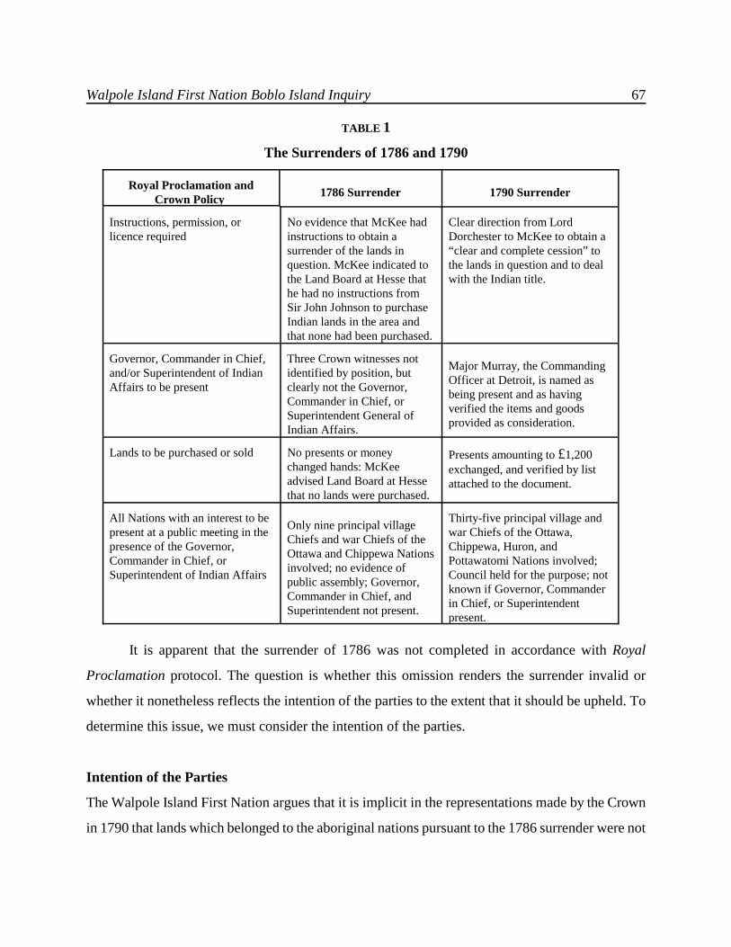
Walpole Island First Nation Boblo Island Inquiry 67
TABLE 1
The Surrenders of 1786 and 1790
Royal Proclamation andCrown Policy
1786 Surrender 1790 Surrender
Instructions, permission, orlicence required
No evidence that McKee hadinstructions to obtain asurrender of the lands inquestion. McKee indicated tothe Land Board at Hesse thathe had no instructions fromSir John Johnson to purchaseIndian lands in the area andthat none had been purchased.
Clear direction from LordDorchester to McKee to obtain a“clear and complete cession” tothe lands in question and to dealwith the Indian title.
Governor, Commander in Chief,and/or Superintendent of IndianAffairs to be present
Three Crown witnesses notidentified by position, butclearly not the Governor,Commander in Chief, orSuperintendent General ofIndian Affairs.
Major Murray, the CommandingOfficer at Detroit, is named asbeing present and as havingverified the items and goodsprovided as consideration.
Lands to be purchased or sold No presents or moneychanged hands: McKeeadvised Land Board at Hessethat no lands were purchased.
Presents amounting to £1,200exchanged, and verified by listattached to the document.
All Nations with an interest to bepresent at a public meeting in thepresence of the Governor,Commander in Chief, orSuperintendent of Indian Affairs
Only nine principal villageChiefs and war Chiefs of theOttawa and Chippewa Nationsinvolved; no evidence ofpublic assembly; Governor,Commander in Chief, andSuperintendent not present.
Thirty-five principal village andwar Chiefs of the Ottawa,Chippewa, Huron, andPottawatomi Nations involved;Council held for the purpose; notknown if Governor, Commanderin Chief, or Superintendentpresent.
It is apparent that the surrender of 1786 was not completed in accordance with Royal
Proclamation protocol. The question is whether this omission renders the surrender invalid or
whether it nonetheless reflects the intention of the parties to the extent that it should be upheld. To
determine this issue, we must consider the intention of the parties.
Intention of the Parties
The Walpole Island First Nation argues that it is implicit in the representations made by the Crown
in 1790 that lands which belonged to the aboriginal nations pursuant to the 1786 surrender were not
68 Indian Claims Commission
188 Submission on Behalf of the Walpole Island First Nation, March 12, 1999, paragraph 41.
189 Submission on Behalf of the Walpole Island First Nation, March 12, 1999, paragraph 42.
190 Submission on Behalf of the Walpole Island First Nation, March 12, 1999, paragraph 43.
191 Submission on Behalf of the Walpole Island First Nation, March 12, 1999, paragraph 52.
192 Submission on Behalf of the Walpole Island First Nation, March 12, 1999, paragraph 98.
193 Submission on Behalf of the Walpole Island First Nation, March 12, 1999, paragraph 76.
194 Submission on Behalf of the Walpole Island First Nation, March 12, 1999, paragraph 77.
195 Submission on Behalf of the Walpole Island First Nation, March 12, 1999, paragraph 80.
ceded and would be protected from encroachment by settlers.188 The First Nation further submits
that, with the exception of Bois Blanc Island, the 1790 surrender reserved the “precise area of land
for the use and benefit of the Indian Nations which had been surrendered to McKee in 1786.”189
According to the First Nation, the 1790 treaty therefore implicitly confirms the intentions of the
parties that the lands covered by the 1786 surrender were intended to be held for the use, benefit, and
protection of the aboriginal nations.190 The First Nation argues that if the 1786 deed was intended
for the Crown’s benefit, and not for the benefit of the Indian Nations, settlement under the Crown’s
authority could have easily proceeded. It did not.191
The Walpole Island First Nation further submits that if the intent of the Crown was to keep
the lands for itself, rather than for the future use and benefit of the Indian Nations, there was a
fraudulent misrepresentation to the Indian signatories which would vitiate consent.192 The First
Nation argues that, when determining the legal effect of dealings between aboriginal peoples and the
Crown, it is preferable to rely on the understanding and intention of the aboriginal nation, rather than
a technical approach.193 The First Nation refers to this approach as the “true purpose of dealings” or
“true intentions” test, citing St. Mary’s Indian Band v. City of Cranbrook and other cases in
support.194 Finally, the First Nation submits that the clear understanding and intention of the Indian
signatories to the 1786 treaty were to convey the lands set out in that treaty to Alexander McKee, and
for him to hold those lands in trust for the use and benefit of the Indian nations.195
Walpole Island First Nation Boblo Island Inquiry 69
196 Submission on Behalf of the Government of Canada, March 22, 1999, paragraph 7.
197 R. v. Sioui, [1990] 1 SCR 1025, 3 CNLR 127 at 133–34 (cited to CNLR).
198 R. v. Marshall, [1999] SCJ no. 55, file 26014 at 9.
By contrast, Canada argues that:
... the First Nation asserts that oral terms surrounding the 1786 surrender confined thefield of Canada’s discretion in the manner in which the lands were to be dealt with.Canada submits that any alleged oral terms did not affect the unconditional nature ofthe surrender and in any event there is no evidence to support the existence of suchoral terms in this case.196
If this argument is accepted, Canada argues, the document is clear and the intention of the parties
is reflected within its terms – namely, an unconditional surrender of lands to the Crown.
We agree with Canada’s submission that there is nothing on the face of the 1786 surrender
to indicate that the lands were to be transferred for any conditional purpose. However, the fact that
the surrender itself does not make reference to the statements attributed to McKee is not
determinative of the matter. In R. v. Sioui, the Supreme Court of Canada held that “the courts should
show flexibility in determining the legal nature of a document recording a transaction with the
Indians. In particular, they must take into account the historical context and perception each party
might have as to the nature of the undertaking contained in the document under consideration.”197
In R. v. Marshall,198 the Supreme Court of Canada held that
... extrinsic evidence is available to show that a written document does not includeall of the terms of an agreement. ...
Secondly, even in the context of a treaty document that purports to containall of the terms, this Court has made clear in recent cases that extrinsic evidence ofthe historical and cultural context of a treaty may be received even absent anyambiguity on the face of the treaty. MacKinnon A.C.J.O. laid down the principle inTaylor and Williams, supra, at p. 236:
... if there is evidence by conduct or otherwise as to how the partiesunderstood the terms of the treaty, then such understanding andpractice is of assistance in giving content to the term or terms.
70 Indian Claims Commission
199 Major Murray, draught respecting the necessity of making a Reserve of Land at the Huron Church andRiver Canard for the Indians, NA, MG 19, F1, Claus Papers, vol. 4, p. 230 (ICC Exhibit 14, document 84).
200 Report of the Land Committee at Quebec, December 24, 1791, NA, RG 1, L1, vol. 18, p. 318 (ICCDocuments, p. 213).
The evidence as to Alexander McKee’s intent in obtaining the 1786 surrender is unclear.
According to Major Patrick Murray, who was present at the 1790 negotiations, the Indian signatories
had surrendered the lands in trust to the Crown for use by the Huron and other Indians and for no
other purpose:
... [T]he Intention and Express Purpose of the Indians by their Deed of cession to theCrown in 1784 [sic] of this tract was in trust for Alex McKee Esq to whose regardfor them, they were agreed to intrust their interests that this Deed being in trust tothe Crown for the above purpose only, it cannot be considered as transferring theProperty to the Crown for any other purpose – and accordingly by the Governor inCouncil only leaves it to the Land Board to Report whether a Grant ought to be Givenor not to Mr. McKee but certainly never considered the Crown as willing to acceptof or dispose of it for any other Purpose than that designed by the Grantors.199
The report of the Land Committee indicated that “Mr. McKee states that the Hurons had ever
considered that Tract to be essential to their comfort – their [the Indians’] sole intention in ceding
it in 1786 was to have it put into Mr. McKee’s hands to prevent encroachments by the Settlers in the
Neighbourhood.”200
McKee later confirmed that, when he solicited the lands, the 1786 surrender was made for
the sole purpose of reserving lands in trust for use of the Huron. He explained in 1790:
... as there is an Indian Settlement on the River Canard that cannot be removedwithout creating confusion and perhaps trouble nor will it be consistent with goodpolicy or humanity to force them to quit it. It was my intention by Soliciting theselands (as Indians were already fixed there) to have accommodated several familiesLikewise which to my knowledge from their attachment to Government have beendrove from their antient [sic] settlements and who in case of emergency might bedepended upon as well as any other Inhabitants, entertaining at the same time an
Walpole Island First Nation Boblo Island Inquiry 71
201 Alexander McKee to Lord Dorchester, May 5, 1790, PRO, CO 42, vol. 68, 215–16d, NA, RG 1, L4,vol. 2, p. 89 (ICC Exhibit 14, document 86). Emphasis added.
202 Alexander McKee to Sir John Johnson, May 25, 1790, NA, RG 1, vol. 3, p. 308 (ICC Documents,148).
203 Henry Motz, Secretary to Lord Dorchester, to Land Board of Hesse, January 21, 1790, NA, RG 1, L4,vol. 2, p. 89 (ICC Documents, p. 106).
204 Patrick McNiff to Land Board of Hesse, April 14, 1790, Third Report of the Bureau of Archives forthe Province of Ontario for 1905 (Toronto: King’s Printer, 1906), 40, referred to in Ernest J. Lajeunesse, The WindsorBorder Region: Canada’s Southernmost Frontier (Toronto: Champlain Society, 1960), cv (ICC Exhibit 3).
Idea that all this description would be encouraged to live within the protection of theBritish Government ...201
On May 25, 1790, McKee wrote to Sir John Johnson describing the tract of land occupied by the
Huron and again providing information as to the intent of “the Indians” in ceding it in 1786:
... That the intention and express purposes of the Deed of Cession to the Crown in1784 [sic] of this Tract, was in trust to me to secure the Indians from encroachments,being convinced they would be disturbed in their possessions, which eventually musthave produced troubles between them and the white Inhabitants, and to evince thetruth of this, I have no Objections to relinquish any Interest or Claim, to the saidTract, for the public good ...202
In 1789, however, McKee had sought to have the 1786 grant formally ratified by the
Governor. He sent the 1786 “deed” and a petition directly to the Governor, who returned it to the
Board at Hesse advising it to “be very particular in your Minutes if you shall see cause in the exercise
of Your discretion to give hopes to persons that indulge expectations under such Indian Grants as
were not made agreeable to the Royal Instructions, nor have yet had the countenance or approbation
of the government.”203
One source indicates that the reasoning behind McKee’s request was “so that he might have
it in his power to place such loyal subjects upon it as he may conceive worthy of such an
indulgence.”204 McKee’s application annoyed Patrick McNiff, the District Surveyor, who complained
to the Board that he had applied for some of the same lands included within McKee’s application:
I have only to observe that should my petition appear to be the first that have gonethrough the regular Channel for that Land, I doubt not you will see the propriety of
72 Indian Claims Commission
205 Patrick McNiff to Land Board of Hesse, April 14, 1790, Third Report of the Bureau of Archives forthe Province of Ontario for1905 (Toronto, King’s Printer, 1906), 40, referred to in Ernest J. Lajeunesse, The WindsorBorder Region: Canada’s Southernmost Frontier (Toronto: Champlain Society, 1960), cv (ICC Exhibit 3).
206 Patrick McNiff to Land Board of Hesse, April 14, 1790, Third Report of the Bureau of Archives forthe Province of Ontario for 1905 (Toronto: King’s Printer, 1906), 40, referred to in Ernest J. Lajeunesse, The WindsorBorder Region: Canada’s Southernmost Frontier (Toronto: Champlain Society, 1960), cv (ICC Exhibit 3).
207 Proceedings of the Land Committee at Quebec, December 24, 1791, NA, RG 1, L1, vol. 18, pp.345–46 (ICC Documents, pp. 200–1), referring to a letter from the Land Board of Hesse to the Land Committee atQuebec, May 6, 1791. Emphasis added.
putting me in possession of a sufficient quantity of the front land, alluded to in mypetition, to make me a small Farm, which is all I at present require. Had I knownprior to my petitioning that Captain McKee had the most distant wish to have theselands, I had not asked for any part of them, I would even now give up my claim atthat place in his favour, were it not for a certain Clause, which I perceive to becontained in the body of his petition for 6 miles square, in which space iscomprehended the Land I have referred to. The Clause plainly expresses that he doesnot want that land for his own use but wishes to have it secured to him so that he mayhave it in his power to place such loyal subjects upon it as he may conceive worthyof such an Indulgence.205
McNiff further complained that if “loyalty” was to be the basis on which lands were granted, he
should be ranked among the first favourites, “but in that case I should conceive to be receiving the
land from his Majesty and not from Captain McKee ...”206
As noted by the Land Office of the Board of Hesse:
... before the 21st May 1790, the Crown had no lands in Hesse, except a square ofseven miles at the River Canard upon the Straight ceded to His Majesty by theOttawa and Chippawa Indians15th May 1786, by Deed: together with another Tractof seven miles ceded the 7th June 1784 by the Chippawas and Hurons at the mouthof the Streight which is claimed as being granted to and for the use of certain Officers& Soldiers who had served in the late War with the Indians, the Grantors of that tract... Alex McKee Esqr. claimed the Tract at the River Canard for his own use and thatof his friends, and had petitioned for a Grant of it under the Crown which petitionwas referred by His Excellency Lord Dorchester to the Board of Hesse the 21st
January 1790 – it was withdrawn by Mr. McKee 14th May 1790 and has not beenreturned since.207
Walpole Island First Nation Boblo Island Inquiry 73
208 Russell M. Raikes, Cohen Highley Vogel & Dawson, to Daniel J. Bellegarde, ICC, May 18, 1999, ICCfile 2105-9-3, vol. 3.
209 Report of the Legislative Council to the Lieutenant Governor of Upper Canada, March 12, 1930, NA,RG 1, E1, p. 327 (ICC Documents, p. 304).
As the minutes reflect, whether because of the complaints raised by McNiff, or for other reasons
unknown to us, McKee was willing to withdraw his own application to the lands included in the
1786 surrender to enable the “Grantors” (the Ottawa and Chippewa) to do as they wished with the
land.
Counsel for the Walpole Island First Nation submitted to the Commission, by letter dated
May 18, 1999, that no apparent direction had been given to McKee in 1786 to secure a surrender of
lands, including Boblo Island. Counsel argues that this lack of direction supports the claimant’s
position that the 1786 transaction was a private one between the Indian nations concerned and
McKee for the purpose of protecting those lands from encroachment by white settlers. Counsel
concludes:
McKee’s subsequent conduct in trying to get the lands on the mainland patented tohimself is consistent with the arrangement which he had with the Indian Nations.208
It is not clear to us that McKee’s attempt to have the lands in question transferred to him can
be described as consistent with the arrangements he later claimed to have entered into with the Indian
Nations to reserve the lands for the Huron. McKee’s actions and words are, to say the least,
inconsistent and conflicting, a point noted as far back as 1830 by a Land Committee reviewing the
materials relating to the 1786 surrender. The Committee found that McKee’s actions were “not very
easy to be reconciled with the terms of the Deed or with his own subsequent application to Lord
Dorchester and to the Land Board.”209
The fact that McKee made application for the lands for his own use is troubling and tends
to put in doubt his subsequent statement that the lands had been secured in trust to the Crown for the
protection of the Huron. As a result, this trust may or may not have been his intention at the time;
however, his statement, and that of Major Murray, reflect the aboriginal perspective on what they
understood to have been achieved through their negotiations. The Ottawa and Chippewa Chiefs
74 Indian Claims Commission
210 R. v. Marshall, [1999] SCJ no. 55, file 26014 at paragraph 10: “Rules of interpretation in contract laware in general more strict than those applicable to treaties ...”
211 See, for example, Gallie v. Lee and Another, [1971] AC 1004 (House of Lords).
212 Captain Thomas McKee, Petite Cote, to Lieutenant Colonel V. Smith, Amherstburg, May 3, 1802, inMichigan Pioneer and Historical Collections 23 (1895):11–12 (ICC Exhibit 14, document 89).
obviously wished to reserve lands for use of the Huron; the 1790 cession of lands in fact reserved
some of the same lands purportedly surrendered in May 1786 for the use of the Huron and other
Indians.
In the case of a surrender, while we must take into account the perspectives of each party, we
must be especially mindful of the intentions of the aboriginal parties, in light of the consequences
flowing from a surrender. If the aboriginal parties to a document do not intend it to operate as a
surrender, but, rather, that it “reserve” lands, we do not believe it can be construed as a surrender
simply because its written terms depict it as such. The surrender in this instance was written in
English. We have no evidence that it was interpreted to its aboriginal signatories. The only evidence
we have is to the effect that the intention of the signatories was to reserve, not surrender, lands. Even
in contracts, which are subject to much stricter interpretive rules than treaties,210 the doctrine of non
est factum applies to prevent those who are not capable of understanding a deed or other document
from being divested of their property.211
We find, then, that the intention of the aboriginal parties to the 1786 surrender was not to
cede the land for use by third parties, but to ensure that the Huron were protected by the Crown from
encroachments by others. This intention applied not only to the mainland tract but to Bois Blanc
Island. We are supported in this conclusion by comments made by McKee’s own son in 1802.
Thomas McKee wrote to Lieutenant Colonel Smith on May 3, 1802, to the effect that Boblo Island
was Indian property and was never ceded to the Crown, adding: “I think it my duty to ... inform you
that when they made the last Session of their Lands to the Crown they stated in their speech that this
Island is expressly reserved for the encampment of their Indian Brethren, which was transmitted to
the Head of the Indian Department.”212
We therefore conclude that the 1786 surrender should not be found to be a cession of lands,
as it does not reflect the intention of the aboriginal parties. As well, it is invalid, as it did not comply
Walpole Island First Nation Boblo Island Inquiry 75
213 Report to Council, July 9, 1754, E.B. O’Callaghan, ed., Documents Relative to the Colonial Historyof the State of New-York ..., 15 vols. (Albany, NY: Weed, Parsons & Co., 1856–87), 6: 888 (ICC Documents, p. 8).
214 Submission on Behalf of the Government of Canada, March 22, 1999, paragraph 43.
215 Submission on Behalf of the Government of Canada, March 22, 1999, paragraph 36. Emphasis inoriginal.
216 Submission on Behalf of the Government of Canada, March 22, 1999, paragraph 4.
with the provisions of the Royal Proclamation, an imperial policy clearly put in place to establish
a protocol that would avoid frauds and abuses and put a stop to the surrender of Indian lands for
“trifling considerations.”213 Alexander McKee took the surrender without instructions to do so, for
purposes that remain unclear. As a result, we do not find that it can be interpreted as a valid
surrender. We find that the surrender did not have the effect of alienating lands to the Crown, in light
of the intention of the aboriginal parties who signed it that it reserve lands, rather than cede them to
the Crown unconditionally for the use of third parties, as was argued by Canada.
Extinguishment
Canada argues that even if the surrender is invalid, the mere taking of the surrender itself evidences
the clear and plain intention of the Sovereign to extinguish aboriginal rights and title within the area
of Boblo Island, and points to the actions of the Sovereign in later years in support. Canada submits
that “[t]he Royal Proclamation was intended to interpose the Crown between Indian Nations and
third parties. It was not intended to affect the Crown’s Royal Prerogative to extinguish aboriginal
rights or title to land.”214 As stated in Canada’s submissions:
It is the Crown’s submission that the Royal Proclamation was a policy, the purposeof which was to regulate “purchases” of Indian lands by third parties. The RoyalProclamation did not affect the inherent right of the Crown to extinguish aboriginalrights.215
It is Canada’s position, then, that the fact that the 1786 surrender was entered into by the
Crown means the surrender had the effect of extinguishing any Indian title to Boblo Island.216 Canada
argues that this is so whether the Walpole Island First Nation was a signatory to the surrender or
76 Indian Claims Commission
217 Submission on Behalf of the Government of Canada, March 22, 1999, paragraph 43.
218 Submission on Behalf of the Government of Canada, March 22, 1999, paragraph 44–45.
219 Submission on Behalf of the Government of Canada, March 22, 1999, paragraph 5.
220 R. v. Marshall, [1999] SCJ no. 55, file 26014 at 10–12. See also R. v. Sioui, [1990] 1 SCR 1025, 3CNLR 127.
221 R. v. Sparrow, [1990] 1 SCR 1075 at 1098–99. See also Delgamuukw v. British Columbia, [1997] 3SCR 1010 at 1043.
222 Submission on Behalf of the Government of Canada, March 22, 1999, paragraph 3.
223 A.G. for Ontario v. Bear Island Foundation et al, [1985] 1 CNLR 1.
224 Submission on Behalf of the Government of Canada, March 22, 1999, paragraphs 46–54.
not.217 Canada argues in support of its position that aboriginal rights prior to 1982 could be
extinguished by unilateral action of the Crown and that the surrender is evidence of the Crown’s
clear and plain intention to extinguish any and all aboriginal rights in the surrendered area.218 Canada
argues that the 1786 surrender therefore has the effect of extinguishing all aboriginal rights in the
area covered by it.219
Unlike some other treaties, such as the peace and friendship treaties220 that do not involve
land, a surrender of land by treaty divests the First Nation affected of its title and extinguishes its
rights. The proof of extinguishment of an aboriginal right, including aboriginal title, lies on the
Crown, and the intention to extinguish aboriginal rights must be “clear and plain.”221 To the extent
to which the Crown relies on the 1786 surrender as evidence of extinguishment,222 it bears the very
high onus of proving extinguishment.
In order to establish extinguishment, it is incumbent on the Crown to prove that the
Sovereign had the clear intention in taking the 1786 surrender to extinguish aboriginal title to lands.
Moreover, a surrender is not a unilateral act, but an agreement between two or more parties. It must
therefore be the intention of both signatories to the agreement that lands be surrendered.
Canada argues in reliance on A.G. for Ontario v. Bear Island Foundation et al223 that a
surrender can extinguish the interests of First Nations that are not parties to it.224 The Walpole Island
First Nation, in contrast, argues that the 1786 surrender is not binding on it, in that its ancestors were
Walpole Island First Nation Boblo Island Inquiry 77
225 Submission on Behalf of the Walpole Island First Nation, March 12, 1999, paragraph 83.
226 Submission on Behalf of the Walpole Island First Nation, March 12, 1999, paragraph 84.
227 Submission on Behalf of the Walpole Island First Nation, March 12, 1999, paragraph 84.
228 Submission on Behalf of the Walpole Island First Nation, March 12, 1999, paragraph 85.
229 Ontario (A.G.) v. Bear Island Foundation, [1989] 2 CNLR 73 at 87.
230 Ontario (A.G.) v. Bear Island Foundation, [1989] 2 CNLR 73 at 86.
231 Ontario (A.G.) v. Bear Island Foundation, [1989] 2 CNLR 73 at 86.
not signatories to the surrender.225 The First Nation argues that the evidence, post 1786, shows that
the First Nation continued to use the island as it had previously until prevented from doing so by
Crown actions.226 As a result, the First Nation argues that there is no adhesion to the treaty as there
was in Bear Island,227 in that there is no compelling evidence that the ancestors of the Walpole Island
First Nation authorized the signatories to sign on their behalf or subsequently ratified the treaty
through separate deed or conduct.228
In Bear Island, the Ontario Court of Appeal held that the “sovereign may express the intent
to extinguish aboriginal rights through a treaty even though the treaty itself may be imperfect in the
sense that not all of the Indian bands or tribes whose lands are involved are signatories.”229 In the
facts before the Court, the Governor General in Council of the province of Canada had ratified the
1850 Robinson Huron Treaty and directed it to be registered in the office of the Registrar General.230
The Sovereign’s intent to take the lands, acting through the Governor in Council, according to the
Court of Appeal, was therefore clear.231
On the facts we have, there is sufficient uncertainty as to the purpose of McKee’s intentions
in obtaining the 1786 surrender, with the result that we are unable to find extinguishment proven
with the requisite degree of proof. McKee may have intended to take the lands, as is alleged by
Canada, for use by third parties or, indeed, for his own use. Alternatively, he may have intended to
reserve the lands for use by the Huron. The evidence is equivocal in this regard. However, the factual
underpinnings to Bear Island do not apply here. In Bear Island, those First Nations that signed the
treaty/surrender intended to surrender lands; the issue arose as to those who had not signed the treaty,
but who were found to have adhered to its provisions later. Regardless of the Crown’s intent in this
78 Indian Claims Commission
232 Submission on Behalf of the Government of Canada, March 22, 1999, paragraph 50.
claim, the aboriginal signatories to the 1786 surrender, according to McKee himself, did not intend
to surrender the lands in question. We do not see how the Crown can rely on this document to prove
the extinguishment of the interest of strangers to it, when, if valid as a treaty, it would not have
extinguished the interest of those First Nations that signed it, according to the principles of treaty
interpretation.
The decision in Bear Island is also distinguishable on its facts. In this instance, Walpole
Island, the taking of the surrender was not ratified by the Governor in Council, as it was in Bear
Island. Instead, the Crown felt the need to deal with the aboriginal title to the tract purportedly
surrendered in 1786 by obtaining a second “cession” of essentially the same lands (at least those on
the mainland) in 1790. Despite the fact that Bois Blanc Island was not dealt with in 1790, we cannot
draw a distinction between the island and the mainland tract. Whatever misgivings the Crown had
about the surrender applied to both locations. Obviously the Crown itself had doubts about the
validity of the surrender obtained in 1786, or it would not have obtained a second one. The fact that
the second surrender reserved the lands purportedly surrendered in 1786 (with the exception of the
island, which was not mentioned) again militates against a finding of “clear and plain” intent to
extinguish the aboriginal interest in the lands at question in 1786.
Canada argues, however, that the fact that the Crown subsequently acted as if it obtained title
to the island is sufficient to prove clear and plain intent. Canada points to the construction of two
blockhouses at each end of the island in 1796; a petition from James Hackett for land for a
lighthouse; the transfer of lands to the province in 1856; and the registration of Crown patents to the
lands in 1868 and 1874 as indicia in support of this intent.232
While, in certain circumstances, the subsequent actions of a party can shed light on its
intentions at an earlier time, we do not find that the subsequent actions of the Crown lead to any firm
conclusions about the Crown’s intention at the time of the purported surrender. That the Crown later
believed it had title to the island and behaved as if it did does not evidence the clear and plain
intention to extinguish title in 1786, but is equally consistent with a mistaken belief later on that a
valid surrender had been obtained in 1786. As was noted by the Supreme Court of Canada, and not
overturned, the British Columbia Court of Appeal in Delgamuukw held that
Walpole Island First Nation Boblo Island Inquiry 79
233 Delgamuukw v. British Columbia, [1997] SCR 1010 at 1043. See Delgamuukw v. British Columbia,[1993] 5 CNLR at 51–55.
234 Delgamuukw v. British Columbia, [1997] SCR 1010 at 1043. See Delgamuukw v. British Columbia,[1993] 5 CNLR at 182–205.
[i]ntention to extinguish must be clear and plain. Although express language is notstrictly necessary, the honour of the Crown requires its intentions to be either expressor manifested by unavoidable implication. Unavoidable implication should not beeasily found – it occurs only where the interpretation of the instrument permits noother result. This, in turn, depends on the nature of the aboriginal interest and of theimpugned grant.233
Similarly, Lambert JA of the British Columbia Court of Appeal (dissenting on other grounds) found
that,
[i]n considering implicit extinguishment ... it will only be held to occur where noother conclusion is possible from the particular instrument or conduct. It could nottake place through adverse dominion. In the case of an inconsistency between aCrown grant of land and aboriginal title, the title should not necessarily give way inthe absence of a clear and plain intention to extinguish. In any case, no grants or otherinterests were granted in the territory prior to 1871, and after that date, the BritishColumbia legislature had no power to legislate to extinguish, by adverse dominion,or otherwise.234
We do not find that the Crown has established a clear and plain intention on the part of the
Sovereign to extinguish the aboriginal interest in lands in 1786. The interpretation of the document
provides an alternative conclusion equally consistent with the evidence – namely, the intention at
the time that the aboriginal interest be protected and reserved for the use of the Huron. As noted
above, adverse dominion is insufficient to supply evidence of implied extinguishment.
ISSUE 2 (a) Were the Chiefs and Principal Men of the Walpole Island First Nation
Signatories to the Alleged Surrender of May 15, 1786?
In light of our findings, it is not necessary to discuss the remaining issues, except where they may
affect the ultimate disposition of this claim.
80 Indian Claims Commission
235 Submission on Behalf of the Government of Canada, March 22, 1999, paragraph 5.
236 James Morrison, “Identity of Signatories to Treaties No. 116 (1786) and No. 2 (1790),” October 1997,pp. 3–4 (ICC Exhibit 13).
237 James Morrison, “Identity of Signatories to Treaties No. 116 (1786) and No. 2 (1790),” October 1997,pp. 3–4 (ICC Exhibit 13).
238 James Morrison, “Identity of Signatories to Treaties No. 116 (1786) and No. 2 (1790),” October 1997,pp. 3–4 (ICC Exhibit 13).
239 Submission on Behalf of the Government of Canada, March 22, 1999, paragraph 42.
240 R. v. Sparrow, [1990] 1 SCR 1075 at 1098–99.
In terms of the second issue, Canada argues that the historical record and the joint research
conducted by James Morrison are inconclusive as to the relationship between the signatories to the
1786 surrender and the current claimant.235 According to the information available, none of the
signatories to the 1786 Treaty can be specifically linked to the Walpole Island First Nation.236 The
four Chippewa signatories to this surrender “belonged to the Thames River and possibly the Pelee
Island/Anderdon regional bands.”237 However, Morrison indicated that while it is relatively simple
to identify the nation of each of the Chiefs, it is difficult to identify particular groups or subdivisions
of the nations involved at the time.238
We address this issue simply because it raises questions as to which party bears the onus of
proof. Canada argues that the onus is on the claimant to prove that there is no connection between
the signatories to the treaty and the Walpole Island First Nation.239
We agree that, in most instances, the onus of proof rests with the claimant. However, where
it is the Crown that relies on a surrender as evidencing extinguishment of title, the onus of proving
extinguishment rests with the Crown.240 It is therefore incumbent on the Crown to prove that the
surrender was valid and that the Walpole Island First Nation was a party to it, or that section 35
rights have otherwise been extinguished. It is not incumbent on the First Nation, as the Crown
described it, to “prove a negative.”
We find on the balance of probabilities that the ancestors of the Walpole Island First Nation
were in all likelihood not signatories to the surrender. Although the evidence is not conclusive, it is
Walpole Island First Nation Boblo Island Inquiry 81
241 R. v. Simon, [1985] 2 SCR 387 at 407–8.
242 R. v. Marshall, [1999] SCJ no. 55, file 26014 at 16, paragraph 37.
sufficient. As stated in R. v. Simon, the burden of proof must not be so high as to be incapable of
proof.241 Furthermore, as noted in R. v. Marshall:
The law sees a finality of interpretation of historical events where finality, accordingto the professional historian, is not possible. The reality, of course, is that the courtsare handed disputes that require for their resolution the finding of certain historicalfacts. The litigating parties cannot await the possibility of a stable academicconsensus. The judicial process must do as best it can.242
ISSUE 2 (b) If They Were Not, Does This Make the Surrender Invalid with Respect to
the Walpole Island First Nation?
Since we have concluded that the 1786 surrender is invalid, the question of adhesion does not apply.
The surrender, in our view, is not valid with respect to anyone, including the Walpole Island First
Nation. As a result, the 1786 surrender does not extinguish whatever aboriginal rights or title may
have existed to Boblo Island in 1786, since the island was not included in the 1790 cession of lands.
We cannot therefore make any determination of this issue other than to recommend that the Walpole
Island First Nation resubmit its claim through the Comprehensive Claims Policy.
ISSUE 3 Was There Consideration for the Transfer?
We have discussed this question under Issue 1.
ISSUE 4 If There Was Not, Does This Render the Surrender Invalid?
We have discussed this question under Issue 1.
ISSUE 5 (a) Did the Crown and/or Indians Regard the Surrender of 1786 as Invalid
When They Entered into the Surrender of 1790?
We have no information as to what the Indians thought of the surrender of 1786 when they entered
into the surrender of 1790.
82 Indian Claims Commission
243 Minutes of the Land Board of Hesse, May 28, 1790, in Third Report of the Bureau of Archives for theProvince of Ontario for 1905 (Toronto: King’s Printer, 1906), 11–12, and handwritten notes of Major Murray’sdissension (ICC Exhibit 12, pp. 84–5).
244 [Sir] John Johnson, Montreal to [Land Committee], January 27, 1791, quoted in Proceedings of theLand Committee at Quebec, February 4, 1791, NA, RG 1, L1, vol. 18, pp. 339–41 (ICC Documents, pp. 173, 194–96).
We have no conclusive information as to the view taken of the 1786 surrender by the Crown
at the time. Certain members of the Land Board of Hesse apparently considered the surrender to be
a valid cession; others, including Major Patrick Murray, who was the Chair of the Board,
disagreed.243 We know, however, that the Crown considered the grant to the Indian officers in 1784
to be invalid. As noted from the minutes of the Land Committee, Sir John Johnson had written in
January 1791 that the Board stopped giving permission to Loyalists to settle, as had been done by
Major Robert Matthews previously, because of its concern that the lands had not legally vested in
the Crown:
From the best information I was able to collect, when in the District of Hesse, of theCauses of the difficulties and impediments that had obstructed Settlement on the Eastside of the Streight of Detroit, I found the following to be the principle vizt The notcontinuing to give permission to Loyalists and Emigrants from the States to take upLands in the manner that had been authorized and practiced by Major Mathews andMajor Close on the Land, ceded to the Indian Officers &c by the Indians previous tothe establishment of the Land Boards, Surveys of which had been made under thedirection of one or both of those Gentlemen, but were not considered as valid by theLand Board, as they did not conceive the Land legally vested in the Crown, nor theSurveyor properly qualified to act, consequently no certificates for Land could begranted till the late [1790] purchase.244
It appears on all the information before us that there was sufficient uncertainty about the
validity of the 1786 surrender for McKee to be instructed three years later to obtain a cession of the
Indian title to lands that included the area purportedly surrendered in 1786. As discussed in Part II,
on August 17, 1789, Governor Dorchester instructed Superintendent Johnson to direct McKee to take
a treaty with the Indians in the District of Hesse, “who may lay claims to pretensions to a tract of
land; beginning at the Western boundary of the last purchase made by the Crown from the Indians
West of Niagara, and extending along the whole, or such part of the borders of Lake Erie, and the
Walpole Island First Nation Boblo Island Inquiry 83
245 Lord Dorchester to Sir John Johnson, August 17, 1789, Third Report of the Bureau of Archives forthe Province of Ontario for 1905 (Toronto: King’s Printer, 1906), 32–33 (ICC Exhibit 14, document 110).
246 See R. v. Sparrow, [1990] 1 SCR 1075 at 1107–8, 1114. See also R. v. Taylor (1981), 34 OR (2d) 360at 367 (Ont. CA).
Streight of Detroit, up to such distance towards Lake Huron, and to such depth from the shore as the
Land board for the District of Hesse shall see expedient to be set apart for the settlement.”245
ISSUE 5 (b) If So, What Is the Effect of the 1790 Surrender on the Alleged Surrender of
1786?
It is common ground between the parties that the 1790 surrender was valid and that it did not include
the surrender of any islands. The only area referred to in 1786 which was not covered by the 1790
surrender was Bois Blanc Island. The parties entered into a second surrender that effectively nullified
the written text of the first by expressly reserving in 1790 most of the lands that had been
“surrendered” in 1786. We find that the 1786 surrender was effectively revoked in 1790 because the
1790 surrender is necessarily inconsistent with its terms.
ISSUE 6 Is the Crown Estopped from Relying upon the Surrender of 1786?
Although we may be suspicious of Alexander McKee’s intent in securing the 1786 surrender, we
would nonetheless have found that the Crown was bound by the representations made in 1790 by
McKee to his superiors as to the intention of the aboriginal parties to reserve, rather than surrender,
lands in a transaction that took place only four years earlier. Since we have found the surrender of
1786 to be invalid, it cannot be relied on by the Crown to prove the extinguishment of aboriginal title
to Boblo Island.
In this regard, it must first be remembered that the honour of the Crown is always at stake
in its dealings with Indian people. Interpretations of treaties and statutory provisions that have an
impact on treaty or aboriginal rights must be approached in a manner that maintains the integrity of
the Crown. Second, it is always assumed that the Crown intends to fulfil its promises. No appearance
of “sharp dealing” will be sanctioned.246 In Sparrow, the Supreme Court cited with approval the
Ontario Court of Appeal decision in R. v. Taylor and Williams:
84 Indian Claims Commission
247 R. v. Taylor, [1981] 3 CNLR 114 at 123.
248 R. v. Badger, [1996] 1 SCR 771 at 794.
249 R. v. Marshall, [1999] SCJ no. 55, file 26014 at 9.
The principles to be applied to the interpretation of Indian treaties have been muchcanvassed over the years. In approaching the terms of a treaty, quite apart from theother considerations already noted, the honour of the Crown is always involved, andno appearance of “sharp dealing” should be sanctioned.247
This principle has most recently been repeated by the Supreme Court of Canada in R. v.
Badger, in which the Court held: “The honour of the Crown is always at stake in its dealings with
Indian people ... It is always assumed that the Crown intends to fulfill its promises. No appearance
of ‘sharp dealing’ will be sanctioned.”248
In R. v. Marshall, the Supreme Court of Canada held it would be unconscionable to permit
the Crown to ignore the oral terms of the agreement reached in 1786:
... where a treaty was concluded verbally and afterwards written up by representativesof the Crown, it would be unconscionable for the Crown to ignore the oral termswhile relying on the written terms, per Dickson, J. (as he then was) in Guerin v. TheQueen [1984] 2 S.C.R. 335. Dickson, J stated for the majority at p. 388:
Nonetheless the Crown in my view was not empowered by thesurrender document to ignore the oral terms which the Bandunderstood would be embodied in the lease. The oral representationsformed the backdrop against which the Crown’s conduct indischarging its fiduciary obligation must be measured. They informand confine the field of discretion in which the Crown was free to act.After the Crown’s agents had induced the Band to surrender its landon the understanding that the land would be leased on certain terms,it would be unconscionable to permit the Crown to simply ignorethose terms.249
We note our concern that Canada has attempted to rely on the surrender as a valid treaty and,
at the same time, to rely on the surrender as evidence of extinguishment in circumstances where the
evidence is at least equivocal and where the Crown’s own representative, Alexander McKee,
indicated it was the intention of the aboriginal signatories that the lands were to be protected for
Walpole Island First Nation Boblo Island Inquiry 85
aboriginal uses, not surrendered for general purposes. A reliance by the Crown on a surrender of Bois
Blanc Island in the circumstances outlined would, in our view, amount to “sharp dealing.” Were it
necessary do so, we would find Canada estopped from relying on the surrender of 1786 as
evidencing the extinguishment of aboriginal title to Boblo Island.
ISSUE 7 Did the Crown Breach Its Fiduciary Obligations in Obtaining the Surrender?
In light of our overall findings, it is not necessary to answer this question.

PART V
CONCLUSIONS AND RECOMMENDATION
We were asked to inquire into Canada’s rejection of the Walpole Island First Nation’s claim to
Boblo Island. The primary issue to resolve was whether a surrender of May 15, 1786, entered into
by Chiefs of the Ottawa and Chippewa Nations and negotiated by Alexander McKee contravened
the provisions of the Royal Proclamation of 1763. Other issues, such as whether there was
consideration for the surrender, were subsumed under this larger issue. These secondary issues
included whether the Walpole Island First Nation was a signatory to the May 15, 1786, surrender;
what the effect was of a later, 1790, surrender on the alleged surrender of 1786; whether the Crown
was estopped from relying on the surrender of 1786; and whether the Crown had breached its
fiduciary obligations in obtaining the surrender.
After carefully reviewing the evidence before us, we concluded that the surrender of May 15,
1786, was invalid on the basis not only that it did not comply with the provisions of the Royal
Proclamation of 1763, but that contextual information indicates that the signatories to the surrender
understood it would reserve lands, not surrender them. In reviewing the intention of the parties, we
concluded that McKee’s later comments to the effect that the lands were to be reserved for the Huron
in 1786 were inconsistent with the terms of the surrender itself. In light of these comments, we
concluded that the Crown would be estopped from relying on the terms of the 1786 surrender as
extinguishing the aboriginal interest in Boblo Island.
We also determined that a 1790 surrender, which reserved most of the same lands as those
purportedly surrendered in 1786, is necessarily inconsistent with the provisions of the 1786 surrender
and therefore revoked it. As a result, the 1786 surrender is of no force or effect.
Given that Bois Blanc Island has not been the subject of any other surrenders and was not
surrendered in 1790, whatever aboriginal title may have existed to Bois Blanc Island in 1786
continues to exist today.
88 Indian Claims Commission
We therefore recommend to the parties:
That the Walpole Island First Nation resubmit its claim to the federalgovernment under the Comprehensive Claims Policy.
FOR THE INDIAN CLAIMS COMMISSION
Daniel J. Bellegarde Roger J. AugustineCommission Co-Chair Commissioner
Dated this 1st day of May, 2000
APPENDIX A
WALPOLE ISLAND FIRST NATION BOBLO ISLAND INQUIRY
1 Planning conference July 12, 1996
2 Pre-hearing conference January 28, 1999
3 Legal argument April 7, 1999
4 Content of formal record
The formal record for Walpole Island First Nation Boblo Island Inquiry consists of thefollowing materials:
� the documentary record (3 volumes of documents)
� 14 exhibits tendered during the inquiry
� transcript of oral submissions (1 volume)
� written submissions of counsel for Canada and for Walpole Island First Nation,including authorities.
The report of the Commission and letters of transmittal to the parties will complete theformal record of this inquiry.