Embed Size (px)
Citation preview

INDIGENOUS NORTHERN MEXICO:THE CONQUEST, SETTLEMENT AND ASSIMILATION
OF NUEVA GALICIA AND NUEVA VIZCAYA
1
By John P. Schmal
September 2017
Copyright © 2017 by John P. Schmal.
All Rights Reserved.

• Speakers of Indigenous Languages: 6.7 Million (2010)
• Percent of People Speaking Indigenous Languages: 6.7% (2010)
• Persons Who Consider Themselves Indigenous: 15.7 Million
• Population of México in 2016: 129 Million
• Number of Ethnolinguistic Groups: 68
• Number of Language Families: 11
• Number of Language Variants: 364
Indigenous México Today
2

Copyright © 2013 by John P. Schmal.
All Rights Reserved.
Indigenous México Today
3

Nueva Galicia and Nueva Vizcaya were north of the area that made up the
Aztec Empire (which was conquered by the Spaniards in 1521). The Aztecs had no military influence in these northern areas before 1521, but they did have
trading relationships with some of the indigenous groups.
Source: University of California at Irvine:
https://eee.uci.edu/programs/humcore/images/Conquest/1-Aztec_Empire_Map.png
4Copyright © 2017 by John P. Schmal.
All Rights Reserved.
In this presentation, we will discuss the indigenous peoples wholived north of the Aztec Empire.
The Aztec Empire

Northern Uto-Aztecan
(13 Languages) – primarily U.S.-based (Hopi, Comanche
& Paiute)
Southern Uto-Aztecan -– of Mexico
(48 Languages)
1. Sonoran (19 Languages) of northeastern México (Mayo, Opata, Yaqui, Cora, Huichol, Tarahumara &
Tepehuán – groups in Sonora, Sinaloa, Nayarit, Chihuahua and
Durango)
2. Aztecan/Náhuatl
(29 Languages) – These languages are spread
through many states of México, in particular the
central and eastern sections.
Source: Lewis, M. Paul (ed.), “Ethnologue: Languages of the World” (16th Edition: SIL International, 2009).
The Uto-Aztecan Linguistic Group (61 Languages)
Many of the indigenous groups living in Northern Mexico and the Southwestern U.S. belonged to the Uto-Aztecan linguistic group.
5

The Uto-Aztecan Language Group: Map
Source: American Journal of Linguistics. 6

Established in 1548, the Spanish province of Nueva Galicia embraced 180,000 kilometers and included most of present-day Jalisco, Nayarit, Aguascalientes and Zacatecas. Across this broad range of territory, a wide array of indigenous groups lived during the Sixteenth Century.
Domingo Lázaro de Arregui, in his Descripción de la Nueva Galicia - published in 1621 - wrote that 72 languages were spoken in the Spanish colonial province of Nueva Galicia.
7
Source: Domingo Lázaro de Arregui, “Descripción de la Nueva Galicia” (Dec. 24, 1621).
Copyright © 2017 by John P. Schmal.
All Rights Reserved.
Nueva Galicia’s Indigenous People

1) The occupation and conquests of Nuño de Guzmán (1529-1531) left a trail of devastation and terror across Jalisco and Zacatecas.
2) The influence of epidemics played a significant role in reducing the indigenous populations (especially in western Jalisco).
3) The Mixtõn Rebellion (1540-1542). The aftermath of this bloody conflict led to widespread enslavement of the Caxcanes.
4) The Chichimeca War (1550-1590). This was forty-year conflict was waged by nearly all the natives of Zacatecas. Spanish settlements came under attack and most were evacuated and/or depopulated.
5) The gradual assimilation that resulted from the “peace by purchase” policy of the Marqués de Villamanrique who offered the Chichimecas incentives for peaceful settlement (conversion, food, clothing, lands and agricultural implements).
8Copyright © 2017 by John P. Schmal.
All Rights Reserved.
The Chichimecas: Conquest and Assimilation

“Chichimecas” was the collective name for a wide range of indigenous groups living throughout Zacatecas, Aguascalientes, Durango, parts of Jalisco and parts of Guanajuato. It is believed that most of these groups spoke languages that were related to Náhuatl (the language of the Aztecs and Mexica) and part of the Uto-Aztecan Stock.
at strategically located depots. . But the greatest contribution to the pacification process was the vast quantity of food, mostly maize and beef. The clothing shipped included coarse woolen cloth, coarse blankets, woven petticoats, shirts, hats and capes. The agricultural implements included plows, hoes, axes, hatchets, leather saddles, and slaughtering knives. But the greatest contribution to the pacification process was the vast quantity of food, mostly maize and beef.
The Chichimeca War ended shortly after 1590. Essentially the Spaniards had bribedthe Chichimecas to make peace by offering them a more luxurious existence withthe trappings of the so-called “civilized world.”
Copyright © 2017 by John P. Schmal.
All Rights Reserved.
Source: Philip Wayne Powell, “Soldiers, Indians and Silver: North America's First Frontier War" (Tempe, Arizona: Center for
Latin American Studies, Arizona State University, 1973).
The Chichimeca Road Block
9

10
Copyright © 2017 by John P. Schmal.
All Rights Reserved.
Source: Wikipedia, “Chichimeca War.”
The Chichimeca Nations in the Sixteenth Century
10

Christian Indians from the south (especially Tlaxcalans) settled among the Chichimecas to
help them adapt to their new existence. In the meantime, Catholic missionaries had began a vigorous campaign to win the hearts and souls of the native people of Zacatecas. By 1596, fourteen monasteries dotted the present-day area of Zacatecas. The peace offensive and missionary efforts of the Spaniards were so successful that within a few years, the Zacatecos and Guachichiles had settled down to peaceful living within the small settlements that now dotted the Zacatecas landscape.
Working in the fields and mines alongside the Aztec, Tlaxcalan, Otomian and Tarascan Indians who had also settled in Zacatecas, the Chichimeca Indians were very rapidly
assimilated and, as historian Phillip Wayne Powell writes, “The Sixteenth-century land of war thus became fully Mexican in its mixture."
Source: Philip Wayne Powell, “Soldiers, Indians and Silver: North America's First Frontier War" (Tempe, Arizona: Center for
Latin American Studies, Arizona State University, 1973).
The Chichimecas: Assimilation & Mestizaje
11

Zacatecos – Western Zacatecas Guachichiles – Eastern Zacatecas Caxcanes – Southwest Zacatecas Tepehuanes, Huicholes and Tecuexes inhabited some southwestern
areas near the borders of Durango, Jalisco and Nayarit.
12Copyright © 2017 by John P. Schmal.
All Rights Reserved.
The Native Groups of Zacatecas

The Guachichile Indians were the most populous Chichimeca nation, occupying about 100,000 square kilometers, from Lake Chapala in Jalisco to modern Saltillo in Coahuila. The Guachichiles inhabited all of eastern Zacatecas , portions of eastern Jalisco and some parts of western San Luis Potosí .
The name "Guachichil" was given to them by the Mexica, and meant “head colored red” (Quaítl = head; Chichitic = red). They had been given this label because they wore red feather headdresses, painted their bodies and their hair red, and wore head coverings (bonetillas) made of hides and painted red.
The Spanish frontiersmen and contemporary writers referred to the Guachichiles "as being the most ferocious, the most valiant, and the most elusive" of all their indigenous adversaries
It is believed that the Guachichile Indians were closely related to the Huichol Indians, who continue to live in Nayarit and the northern fringes of Zacatecas in the present day era… Consider the similarity of “Guachil” and “Huichol” – the theory states that the Huichol were a subgroup that moved to the west and developed their own culture and language. The Huicholes also took great efforts to move to isolated areas to avoid the onslaught of the Spaniards and their indigenous allies.
13
Sources: Stacy B. Schaefer and Peter T. Furst (eds.), "People of the Peyote: Huichol Indian History, Religion,
and Survival" (1996); Philip Wayne Powell, "Soldiers, Indians and Silver: North America's First Frontier War" (1973).
The Guachichiles

Presently, the Huichol live primarily in the States of Jalisco and Nayarit. At the time of the 2010 Mexican census, 44,788 people were known to speak this language, which belongs to the Pima-Cora family.
The actual number of Huichol is difficult to determine due to the inaccessibility of the mountainous territory in which they live (many peaks over 9,000 feet) and the natural suspicion the Huichol have of strangers. The Huichol have protected their traditional culture by removing themselves from areas where non-Huichol have come to live. Both men and women wear traditional clothing, with the men’s ceremonial clothing being some of the most traditional in Mexico.
14Copyright © 2017 by John P. Schmal.
All Rights Reserved.
The Huicholes

The nation of the Guamares, located in the Guanajuato Sierras, was centered around Penjamo and San Miguel. They extended as far north as San Felipe, and almost to Querétaro in the east. They also extended as far west as Aguascalientes and Lagos de Moreno.
The author Gonzalo de las Casas called the Guamares "the bravest, most warlike, treacherous, and destructive of all the Chichimecas, and the most astute (dispuesta)."
Some Guamares -- known as IXTLACHICHIMECAS (The Chichimecas Blancos) -- lived in the region between Jalostotitlán and Aguascalientes.This branch of the Guamares painted their heads white. However, much like the Guachichiles, many of the Guamares colored their long hair red and painted the body with various colors (in particular red).
15Copyright © 2017 by John P. Schmal.
All Rights Reserved.
The Guamares

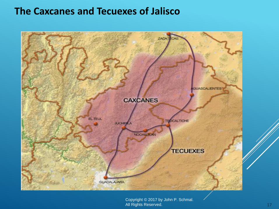
The Tecuexes and Cocas of Jalisco
16Copyright © 2017 by John P. Schmal.
All Rights Reserved.
Source: Carolyn Baus de Czitrom, “Tecuexes y Cocas: Dos Grupos de la Region Jalisco en el Siglo XVI” (1992).
The Tecuexes and Cocas represent the lifeblood of Jalisco and its culture.
17Copyright © 2017 by John P. Schmal.
All Rights Reserved.
The Caxcanes and Tecuexes of Jalisco

The Caxcanes Indians occupied portions of present day Aguascalientes, southern Zacatecas and northern Jalisco. They spoke an Uto-Aztecan language. Dr. Phil C. Weigand has theorized that the Caxcan Indians probably originated in the Chalchihuites area of northwestern Zacatecas. After the collapse of the Chalchihuites culture around 900 to 1000 A.D., Dr. Weigand believes that "the Caxcanes began a prolonged period of southern expansion" into parts of Jalisco.
Dr. Weigand has further noted that - at the time of the Spanish contact -the Cazcanes "were probably organized into small conquest states." He also states that the "overriding theme of their history seems to have been a steady expansion carried by warfare, to the south."
18Copyright © 2017 by John P. Schmal.
All Rights Reserved.
The Caxcanes

The Cora, or Na'ayarij, people inhabit the rugged mountains and deep canyons of the Sierra del Nayar, which is part of the extensive wide-ranging Sierra Madre Occidental.
Most of the 20,078 Coras in Mexico (according to the 2010 census) live in Nayarit state. The conquest of most of Nayarit did not really begin until 1592 when Captain Miguel Caldera entered the Sierra.
In 1612, the Cora, Tarahumaras and Tepehuanes all revolted against Spanish rule. But the Cora were not fully taken over until 1722.
19Copyright © 2017 by John P. Schmal.
All Rights Reserved.
Indigenous Nayarit

Copyright © 2017 by John P. Schmal.
All Rights Reserved.
Nueva Vizcaya
Nueva Vizcaya: Native Languages at Contact (Mid-Sixteenth Century)
Stock Family Languages
Uto-Aztecan
Aztecoidan Guachichil, Lagunero, Zacateco
Piman Pima Bajo, Tepehuán
Taracahitan
Acaxee-Xiximee, Concho (including Chiso, Jumano,
Suma?), Chínipa, Guazápar, Tarahumar, Témori, Toba
(Jova), Toboso, Tubar, Varohío (Guarojío)
Athapaskan* Jano (?)
Hokaltecan Coahuiltecan Borrado (Quinigua)Source: Peter Gerhard, “The North Frontier of New Spain” (Princeton University Press: 1982).The languages that are still spoken today are Pima Bajo, Tepehuán, Tarahumar and Varohío.* The Apache – who began moving into the area in 1700s – spoke an Athapaskan language, but were not in Nueva Vizcaya at the time of the original Spanish-Native contact.
From 1563 to 1565, Francisco de Ibarra traveled through the Nueva Vizcaya, constructing settlements of a permanent nature. It was Ibarra who gave this area its name, after his home province of Vizcaya in Spain. Ibarra founded Durango in 1563. By the 1570s, silver mines had been opened, cattle were introduced, and wheat was planted in thechain of settlements extending from Durango to San Bartolomé (founded in 1569, now known as Valle de Allende).
20

The Spaniards found both silver and indigenous people.
1550: The historical geographer Peter Gerhard (1920-2006) estimated a Nueva Vizcaya population of 344,500 in 1550. By 1700, the population would drop to under 100,000, mainly due to epidemics from “Old World diseases.”
1567: The discovery of silver in Conchos territory made Santa Barbara (Chihuahua) into a wealthy frontier town of slavers, ranchers, miners, adventurers, and priests.
1631: Silver was discovered in Hidalgo de Parral (southern Chihuahua). Peter Gerhard noted that :
The Parral bonanza of 1631 brought a horde of rowdy elements to a frontier until then little exploited, initiating a period of hostilities with the desert tribes of the north that was to continue, with few interruptions and frequent crescendos of violence, for two centuries and more.
Copyright © 2017 by John P. Schmal.
All Rights Reserved.
Source: Peter Gerhard, “The North Frontier of New Spain” (Princeton University Press: 1982), pp. 161-174.
As They Moved North…
21
In referencing the “ethnic complexity of the region,” William B. Griffen’s “Indian
Assimilation in the Franciscan Area of Nueva Vizcaya” provides 127 tribal names for indigenous bands and tribal groups in the area the Spaniards referred to as the “Greater Conchería.” However, because this list included “possible alternate
designations” of some groups, Griffen only offers detailed descriptions of 89 bands and tribal groups in all. However, Griffen also cautions that a large number of these groups “are not placeable, linguistically or geographically, except within rather broad limits.”
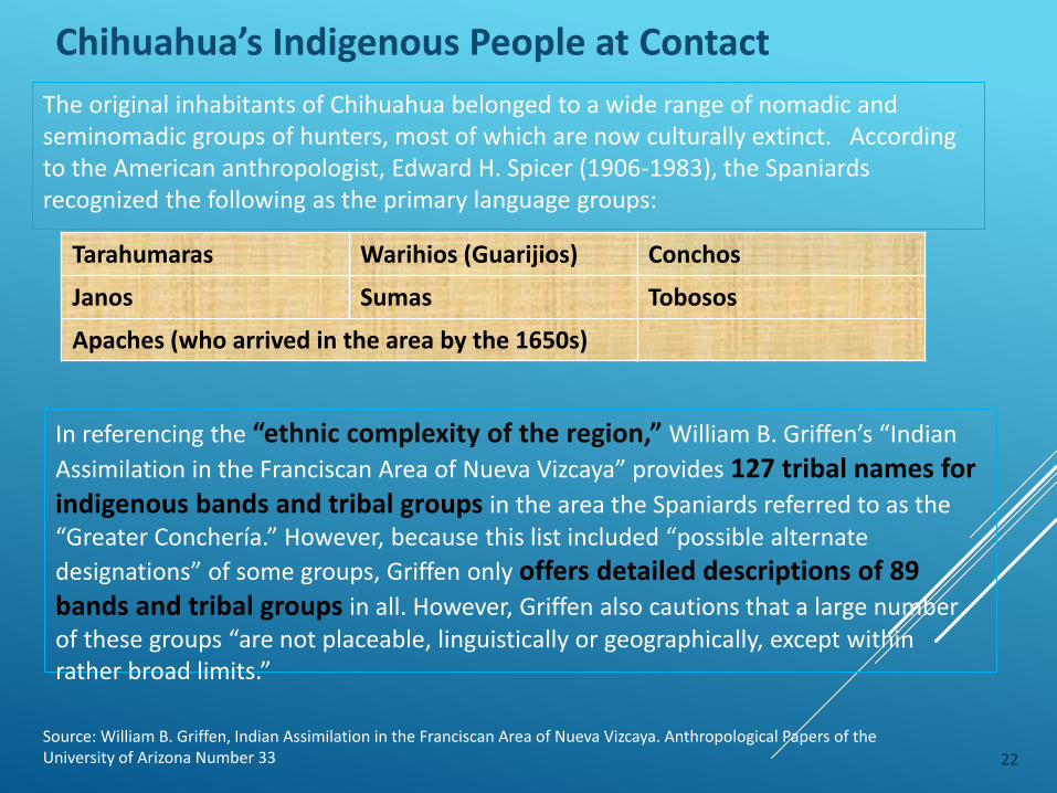
Chihuahua’s Indigenous People at Contact
Source: William B. Griffen, Indian Assimilation in the Franciscan Area of Nueva Vizcaya. Anthropological Papers of the University of Arizona Number 33 22
The original inhabitants of Chihuahua belonged to a wide range of nomadic and seminomadic groups of hunters, most of which are now culturally extinct. According to the American anthropologist, Edward H. Spicer (1906-1983), the Spaniards recognized the following as the primary language groups:
Tarahumaras Warihios (Guarijios) Conchos
Janos Sumas Tobosos
Apaches (who arrived in the area by the 1650s)

Indigenous Northern Chihuahua
Source: Wikipedia, “Conchos.” Online: https://es.wikipedia.org/wiki/Conchos 23

Indigenous Southern Chihuahua
Source: Wikipedia, “Conchos.” Online: https://es.wikipedia.org/wiki/Conchos 24

Copyright © 2017 by John P. Schmal.
All Rights Reserved.
Source: William B. Griffen, “Indian Assimilation in the Franciscan Area of Nueva Vizcaya:
Anthropological Papers of the University of Arizona Number 33” (Tucson: The University of Arizona Press, 1979).
The Conchos: Named for the Spanish word for “shells,” the Conchos
lived near the junction of the Rio Concho River and Rio Grande Rivers in northern Chihuahua (near present-day towns of Presidio (Texas) and Ojinaga (Chihuahua). The Chinarra and Chizos were subdivisions of the Conchos in the east. They were subdued in the 1600s.
The Tobosos: Regarded as a “predatory tribe living in the Seventeenth
Century in the Bolson de Mapimi and extending northward at least to the Río Grande.
The Tobosos lived south and west of the Conchos and their southern territory reached Gómez Palacios. They frequently raided Spanish settlements but died out in the 1700s – and were replaced by the Apaches.
The Indigenous Tribes of Chihuahua
25

Copyright © 2017 by John P. Schmal.
All Rights Reserved.
The Nueva Vizcaya Indigenous Revolts (1601-1689)
Date Tribe / Tribes Region Affected
1601 Acaxee RevoltNorthwestern Durango / East Central
Sinaloa
1610 Xiximes Revolt Northwestern and Western Durango
1616-20 Tepehuanes RevoltWestern & Northwestern Durango /
Southern Chihuahua
1621-1622 Tarahumara RevoltNortheastern Durango / Southern
Chihuahua
1655-1652Revolt of the Tobosos, Salineros &
Conchos
Eastern & Northwestern Durango /
Southern Chihuahua
1648-1652 Revolt of the Tarahumara Southern Chihuahua
1666-1680Revolt of the Salineros, Conchos,
Tobosos and Tarahumara
Northeastern Durango / Southern &
Western Chihuahua
1680-1689The Great Northern Revoltof the Salineros, Conchos, Tobosos,
Tarahumaras and the Pueblos
New Mexico / Northeastern Durango /
Southern and Western Chihuahua
26

The Tepehuanes – the people of the mountains – occupied an extensive area of the Sierra Madre Mountains from northern Jalisco, through present-day Durango, and northward to southern Chihuahua. The first Jesuits, bearing gifts of seeds, tools, clothing and livestock, went to work among the Tepehuanes in 1596. Between 1596 and 1616, eight Jesuit priests had converted the majority of the Tepehuanes.
However, epidemics struck the Tepehuanes population in 1594, 1601-02, 1606-07, and 1612-1615, The epidemics were among the catalysts that led to the Revolt of 1616-1619. The revolt was crushed by the Spaniards, but other revolts followed.
The Tepehuanes
Sources: Susan M. Deeds, "Indigenous Rebellions on the Northern Mexican MissionFrontier: From First-Generation to Later Colonial Responses” (1998); Historia Cultural, “Pueblos Los Tepehuanes.” Online: http://www.historiacultural.com/2015/02/pueblo-los-tepehuanes.html
27Copyright © 2017 by John P. Schmal.
All Rights Reserved.

The Tarahumara Indians of Chihuahua originally occupied more than 28,000 square miles of mountainous terrain, an area that is larger than West Virginia. Today, the Tarahumara are a people whose rich spiritual ideology and strong cultural identity have persevered despite the intrusion of foreign customs.
When the Spaniards encountered the Tarahumara in the late Sixteenth Century, they retreated to less accessible canyons and valleys in the Sierra Tarahumara. Occupying an extensive stretch of the Sierra Madre Mountains, the Tarahumara Indians were ranchería people who planted corn along the ridges of hills and in valleys. During the winters, they retreated to the lowlands or the deep gorges to seek shelter. Some of them lived in cave excavations along cliffs or in stone masonry houses.
The Tarahumara received their first visit from a Jesuit missionary in 1607. But the ranchería settlement pattern of both the Tepehuanes and Tarahumara represented a serious obstacle to the efforts of the missionaries who sought to concentrate the Amerindian settlements into compact communities close to the missions. The Tarahumara participated in several rebellions.
The Tarahumara
28
Copyright © 2017 by John P. Schmal.
All Rights Reserved.
Source: William B. Griffen, “Indian Assimilation in the Franciscan Area of Nueva Vizcaya:
Anthropological Papers of the University of Arizona Number 33” (Tucson: The University of Arizona Press, 1979).
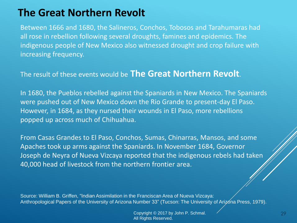
Between 1666 and 1680, the Salineros, Conchos, Tobosos and Tarahumaras had all rose in rebellion following several droughts, famines and epidemics. The indigenous people of New Mexico also witnessed drought and crop failure with increasing frequency.
The result of these events would be The Great Northern Revolt.
In 1680, the Pueblos rebelled against the Spaniards in New Mexico. The Spaniards were pushed out of New Mexico down the Rio Grande to present-day El Paso. However, in 1684, as they nursed their wounds in El Paso, more rebellions popped up across much of Chihuahua.
From Casas Grandes to El Paso, Conchos, Sumas, Chinarras, Mansos, and some Apaches took up arms against the Spaniards. In November 1684, Governor Joseph de Neyra of Nueva Vizcaya reported that the indigenous rebels had taken 40,000 head of livestock from the northern frontier area.
The Great Northern Revolt
29

Copyright © 2017 by John P. Schmal.
All Rights Reserved.
Source: William B. Griffen, “Indian Assimilation in the Franciscan Area of Nueva Vizcaya:
Anthropological Papers of the University of Arizona Number 33” (Tucson: The University of Arizona Press, 1979).
Major hostilities took place in Chihuahua during the latter half of the 1680s, and the Spaniards were able to triumph in most cases. Then, in 1690, the Tarahumaras revolted again in 1690 and they were not defeated until 1698.
Epidemics of measles and smallpox broke out among the Tarahumara in 1693 and 1695. During this time, a belief developed that the ringing of church bells spread measles and smallpox. This may have contributed to the continuing upheaval of the Tarahumaras. Units from several presidios had to be concentrated in bringing the rebellious Tarahumara under control one more time.
This revolt, lasting from 1680 into the 1690s was waged in New Mexico, Northeastern Durango, Southern and Western Chihuahua, and also affected parts of Sonora, Coahuila and Texas.
In 1692, the Spaniards returned to New Mexico.
The Great Northern Revolt
30

The Apache NationsHistorian Cynthia Radding referred to the Apaches as “diverse bands of hunter-gatherers related linguistically to the Athapaskan speakers of Alaska and western Canada.” The Apaches were composed of six regional groups:
1. The Western Apaches (Coyotero)of eastern Arizona
2. the Chiricahua of southwestern New Mexico, southeastern Arizona, Chihuahua and Sonora;
3. the Mescalero of southern New Mexico
4. the Jicarilla of Colorado, northern New Mexico and northwestern Texas
5. the Lipan Apache of New Mexico and Texas
6. the Kiowa Apache of Colorado, Oklahoma, and Texas
Cynthia Radding, "The Colonial Pact and Changing Ethnic Frontiers in Highland Sonora, 1740-1840," in Donna J. Guy and Thomas E. Sheridan (eds.), Contested Ground: Comparative Frontiers on the Northern and Southern Edges of the Spanish Empire,pp. 52-66. (Tucson: The University of Arizona Press, 1998) 31

The Apache Raiding Paths
The Apaches originated in Canada and arrived in the present-day American Southwest between A.D. 1000 and 1400. They migrated south along the eastern side of the Rocky Mountains into New Mexico and Arizona.
In time, the Apaches acquired horses from the Spaniards in New Mexico. However, the Apache expansion was intensified by the Pueblo Indian Revolt of 1680, when the Apaches lost their prime source of horses and shifted south to prey on Spanish settlements in Chihuahua and Coahuila, utilizing numerous existing paths.
Source: From the Texas State Historical Association (TSHA),from The University of Virginia; Images included in accordance with Title 17 U.S.C. Section 107.
32
The Apache Nations
By the 1750s, the Chiricahua had begun hunting and raiding along the mountainous
frontier regions of both Sonora and Chihuahua. The Spaniards and their indigenous
allies waged several campaigns against them during the next decade.
Between 1753 and 1760, the Apache raiders attacked the regions around Casas
Grandes and San Buenaventura and by the 1770s, bands of Apaches were striking at
struck numerous locations near Chihuahua City and Parral. On April 21, Bernardo de
Galvez, leading a force of 110 men, fought a battle with 250 Apaches, killing fifty-
eight of the enemy. But in the years to follow, the Apaches continued to engaged the
Spaniards in numerous locations.
It is important to note that during these times, the Apaches did not have a central
leadership.
33Copyright © 2017 by John P. Schmal.
All Rights Reserved.

A State of Constant Warfare
The pressure of constant warfare waged against the Apaches led the Spanish military to adopt a policy of maintaining armed garrisons of paid soldiers (presidios) in the problem areas.
By 1760, Spain boasted a total of twenty-three presidios in the frontier regions.
But the Apaches, responding to these garrisons, developed "important adaptations in their mode of subsistence, warfare, and social organization.” They became highly skilled horsemen whose mobility helped them elude presidio troops.
Sources: Robert Mario Salmon, ”Indian Revolts in Northern New Spain: A Synthesis of Resistance (1680-1786).” Lanham, Maryland: University Press of America, 1991; World Press, “La Apachería en el Siglo XVII” (World Press).
Online: https://apacheria.es/la-apacheria-en-el-siglo-xvii/.
34Copyright © 2017 by John P. Schmal.
All Rights Reserved.

A State of Constant WarfareProfessor Robert Salmon, the author of “Indian Revolts in Northern New Spain: A Synthesis of Resistance (1680-1786)” writes that the continuing Indian attacks eventually
"broke the chain of ineffective presidios established to control them." During this time, the Apaches represented a major threat to the continued Spanish occupation of Sonora and Chihuahua. And, as Professor Salmon concludes, "Indian warriors exacted high tolls in commerce, livestock, and lives.“
The intensity of the conflict was at its peak from 1771 to 1776 when 1,674 Spaniards and mestizos were killed and over 68,000 animals were stolen throughout Chihuahua and Coahuila. At various points, the Spaniards formed alliances with the Pimas and Opatas to oppose the Apaches.
In 1786, New Mexico made peace with the Comanches, and many of those warriors joined the Spaniards in military operations against the Apache. In 1786, the Spaniards launched their own peace initiative with the Apaches and, by 1790, most of the Apache bands had made peace with the Spanish. By 1793, almost 2,000 Apache were settled at a dozen presidios, including 400 at Janos and 800 at El Norte (El Paso, Texas). Relative peace between the Apaches and the Spaniards and the Mexicans would endure until 1831.
Sources: Robert Mario Salmon, ”Indian Revolts in Northern New Spain: A Synthesis of Resistance (1680-1786).” Lanham, Maryland: University Press of America, 1991.
35Copyright © 2017 by John P. Schmal.
All Rights Reserved.

Missions as a Place of Refuge
Over time, the Apache raids in Chihuahua, Coahuila, Texas and Nuevo León displaced many of the nomadic hunter-gatherer groups, including the Sumas, Mansos, Chinarras, Jócomes, Janos and the wide-ranging Coahuiltecans.
In addition, epidemic diseases depleted the indigenous populations, making them even more vulnerable to their highly-mobile Apache enemy.
Eventually, the numerous Spanish missions in the region would provide a refuge for the displaced and declining Indian populations. Usually the missions had a presidio located nearby, and this military garrison could provide protection for the refugees.
36Copyright © 2017 by John P. Schmal.
All Rights Reserved.

Benefits of the Mission Life
Each mission village usually became home to dozens of indigenous groups who came from the surrounding areas. The former hunter-gatherers were willing to become part of the mission system for a number of reasons:
1. The irrigation system promised a more stable supply of food than they normally enjoyed.
2. The presidio – frequently located close to a mission -- offered much greater protection from the Apaches.
3. The missionaries and their lay helpers instructed the natives in the Catholic faith and in the elements of Spanish peasant society. The Indians learned various trades, including carpentry, masonry, blacksmithing, and weaving; they also did a great deal of agricultural work.
In the mission system, local Indians mixed with displaced groups from Coahuila,
Chihuahua and Texas. This displacement created an unusual ethnic mix that led to the assimilation of many of the Northern Mexican Indians.
37Copyright © 2017 by John P. Schmal.
All Rights Reserved.

The Coahuiltecans
The Coahuiltecan tribes were made up of hundreds of small autonomous bands of hunter-gatherers who ranged over the eastern part of Coahuila, northern Tamaulipas, Nuevo León and southern Texas.
Collectively, it is believed that the Coahuiltecan tribes spoke at least seven dialects, the best known of which were the Comecrudo and Cotoname.
Estimates of the total Coahuiltecan population in 1690 vary. One historian compiled a list of 614 Coahuiltecan group names in northeastern Mexico and southern Texas. The average population per group was estimated at 140, giving us a population of 86,000.
Sources: Texas State Historical Association, “The Handbook of Texas: The Coahuiltecan Indians”; “Texas Beyond History: Native Peoples in a Spanish World (University of Texas at Austin).
38

The Major Coahuiltecans TribesThe 1955 Master’s Thesis by Frederick Henry Ruecking for the University of Texas, “The Coahuiltecan Indians of Southern Texas and Northeastern Mexico” provided the following map of the major tribal groups during the Eighteenth Century. His extensive study provides detail information on the Coahuiltecan culture and way of life.
Sources: Frederick Henry Ruecking, “The Coahuiltecan Indians of Southern Texas and Northeastern Mexico” (August 1955: Master’s Thesis: The University of Texas). 39

The Coahuiltecan Tribes
The Coahuiltecans drove the Spaniards out of Nuevo León in 1587, but they lacked the organization and political unity to mount an effective defense when a larger number of Spanish settlers returned in 1596.
Some conflicts between the Coahuiltecan peoples and the Spaniards continued throughout the 17th century. However, smallpox and measles epidemics were frequent and took their toll on the population.
In time, many of the Coahuiltecan natives were displaced from their traditional territories by Spaniards advancing from the south and Apaches advancing from the north.
The Spanish settlement in the lower Rio Grande began in 1748 (the Nuevo Santander Colony). Nine years later, fourteen different bands of Coahuiltecans were counted in the area. However, this last stronghold of the Coahuiltecans was eventually overwhelmed by the large number of Spanish settlers and they were assimilated and absorbed into Spanish society within a few decades. By 1825, most of them had disappeared.
Sources: Texas State Historical Association, “The Handbook of Texas: The Coahuiltecan Indians”; “Texas Beyond History: Native Peoples in a Spanish World (University of Texas at Austin).
40

Nuevo Santander is a region corresponding
generally to the modern Mexican state of Tamaulipas and southern Texas. Between 1747-1755, the Spanish created 23 towns and 15 missions straddled along the Rio Grande River. In all, 6,000 colonists took up residence in this region.
By 1800, Nuevo Santander had one city, 25 villas, 3 mining districts, 17 haciendas, 437 ranchos and eight missions – and consisted of about 30,000 people.
Many famous Tejano families – de la Guerra, de la Pena, Benavidez, Villarreal, Leal, Montemayor, Longoria, Trevino and Guerra – were part of the original settlement and later moved northward to other parts of Texas. They are the ancestors of many Texans living today.
Nuevo Santander
Source: San Benito History, “Nuevo Santander.” Online: http://www.sanbenitohistory.com/projects/Greatest_Colonizer/Map.html
41Copyright © 2017 by John P. Schmal.
All Rights Reserved.
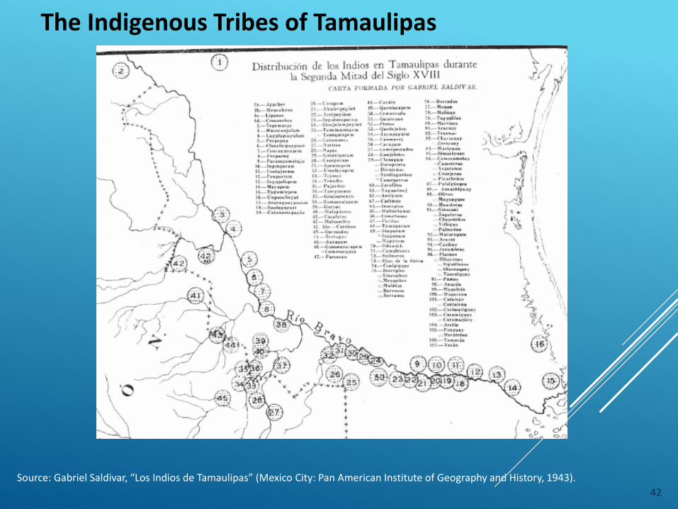
Source: Gabriel Saldivar, “Los Indios de Tamaulipas” (Mexico City: Pan American Institute of Geography and History, 1943).
The Indigenous Tribes of Tamaulipas
42

Indigenous Northwest Mexico at “Contact”
Copyright © 2017 by John P. Schmal.
All Rights Reserved. 43

In March 1531, Nuño de Guzmán's army reached the site of present-day Culiacán (now in Sinaloa), where his force engaged an army of 30,000 warriors in a pitched battle. The indigenous forces were decisively defeated and many were enslaved.
The native people occupying the Sinaloa and Sonora coastal region belonged to the Cáhita language group. Speaking eighteen closely related dialects, the Cáhita peoples of Sinaloa and Sonora numbered about 115,000 and were the most numerous of any single language group in northern Mexico.
The Spaniards called the Cahitan speakers "ranchería people." Their fixed points of settlements (rancherías) were usually scattered over an area of several miles and one dwelling may be separated from the next by up to half a mile.
The Sonora and Sinaloa Languages at Contact (1531)
Source: Edward H. Spicer, “Cycles of Conquest: The Impact of Spain, Mexico, and the United States on the Indians of the Southwest, 1533-1960.”Tucson, Arizona: University of Arizona Press, 1997.
44

Year (s) Event
1531 Guzman fights the Cáhita speakers (Sinaloa & Sonora).
1599-1600 Hurdaide’s Offensive in Sinaloa.
1609-1610 Spaniards make contact with Mayo and Yaquis.
1613-1620 The Mayos and Yaquis are converted to Christianity.
1740 The Yaqui, Pima and Mayo Indians revolt.
1751-52 The Pima of Sonora rebel against the Spaniards.
1751-54 Apaches attack both Sonora and Chihuahua.
1757-71 The Seris battle the Spaniards in Sonora.
1767 The Jesuits are banished from Mexico
1825-1833 The Yaqui, Mayo and Opata rebel in Sonora & Sinaloa against the newly independent Mexican Government.
1832-1833 The Yaqui leader Banderas forms an alliance with the Opatas and wageswar on the Mexican army. Banderas is captured in Dec 1832 and executed in 1833, along with other Yaquis, Mayo and Opata leaders.
Sinaloa and Sonora: A Chronicle of Indigenous Resistance
Source: John P. Schmal, “Watching the Yaquis from Los Angeles (1894-1937): Enduring Resistance in the Face of Extermination,” Latinola.com, Jan. 7, 2010.
45

Copyright © 2017 by John P. Schmal.
All Rights Reserved.
Year (s) Event
1838-1868 The Yaquis rebel against
1867 Governor Pesqueira of Sonora sends military expeditions under the command of Gen. Jesus Garcia Morales against the Yaquis. The Yaquis were pacified after a ruthless campaign.
1868-1875 Intermittent Yaqui resistance took place.
1876-1887 A Yaqui and a veteran of the Mexican army name Cajeme begins a new Yaqui resistance by demanding self-government for the Yaquis. The Mayos joined the rebellion in 1877.
1885-1901 Mexican President Porfirio Diaz and the Sonora Government wage continuous war against the Yaquis
1901 The Yaqui rebel leader Tetabiate is betrayed and murdered.
1902-1910 Some Yaquis are rounded up and deported to the Yucatan. Between 8 and 15,000 of the 30,000 Yaquis are allegedly deported during this period.
Sinaloa and Sonora: A Chronicle of Indigenous Resistance
Source: John P. Schmal, “Watching the Yaquis from Los Angeles (1894-1937): Enduring Resistance in the Face of Extermination,” Latinola.com, Jan. 7, 2010. Online: http://latinola.com/story.php?story=8208
46

Copyright © 2017 by John P. Schmal.
All Rights Reserved.
Year (s) Event
1905 A government study cited 270 instances of Yaqui and Mayo warfare between 1529 and 1902, excluding eighty-five years of relative peace between 1740 and 1825.
1927 The Yaquis fight their last major battle at Cerro del Gallo (Hill of the Rooster). Mexican Federal Troops captured 415 Yaquis, including 214 women and 175 children.
1936-37 Mexican President Cárdenas, proud of his Indian blood, serves notice that his government would provide extensive benefits for the Yaquis. In 1937, Cardenas signs a treaty that creates the Yaqui Zona Indígena, which included approximately half of the territory that the Yaquis had claimed as their traditional homeland.
Sinaloa and Sonora: A Chronicle of Indigenous Resistance
Source: John P. Schmal, “Watching the Yaquis from Los Angeles (1894-1937): Enduring Resistance in the Face of Extermination,” Latinola.com, Jan. 7, 2010. Online: http://latinola.com/story.php?story=8208
47

Copyright © 2017 by John P. Schmal.
All Rights Reserved.
Mayos: Southeast Sonora and northern Sinaloa
Yaquis: Southern Sonora
Seris: Central and Northwest Sonora
Pápagos: Northwest Sonora near the U.S. border
Pimas: living in Ures and Saharipa, San Ignacio
Guarijios: Southeast Sonora
Source: “Etnias de Sonora: Indígenas de
Sonora.”
Indigenous Sonora Today
48

The 1921 Mexican Census: The “Blanca” Factor
StateIndígena Pura
(% of Total State Population)
Indígena Mezclada con Blanca (% of State Population)
Blanca (% of State Population)
Extranjeros sin distinción de razas
(% of State Population)
Jalisco 16.76% 75.83% 7.31% 0.10%Aguascalientes 16.70% 66.10% 16.80% 0.40%Tamaulipas 13.80% 69.36% 13.54% 2.69%Sonora 13.78% 40.38% 41.85% 2.05%Chihuahua 12.76% 50.09% 36.33% 0.82%Coahuila 11.38% 77.88% 10.13% 0.615%Zacatecas 8.54% 86.10% 5.25% 0.10%Durango 9.90% 89.10% 0.01% 0.15%Baja California 7.72% 72.50% 0.35% 19.33%Nuevo León 5.14% 75.47% 19.23% 0.08%Sinaloa 0.93% 98.30% 0.19% 0.58%
Mexican Republic 29.16% 59.33% 9.80% 0.71%Classifications: Indígena Pura (Pure Indigenous Origins); Indígena Mezclada con Blanca (Indigenous Mixed with White); Blanca (White);Extranjeros sin distinction de razas (Foreigners without racial distinction) One percent of the population of the Republic of Mexico chose a fifth option: “Cualquiera otra o que se ignora la raza” (persons who chose to ignore the question or “other.”Source: Departamento de la Estadística Nacional, “Annuario de 1930” (Tacubaya, Distrito Federal, 1932).
The states of Sonora, Chihuahua, Nuevo León and Tamaulipas had a larger than average percent of “Blanca” residents in 1921. They also had much smaller populations of “pure indigenous” people.
49

The 2010 Mexican Census
StateNo. of
Indigenous Speakers
PercentIndigenous Speakers
Percent Persons
Considered Indigenous
Most Common
Indigenous Language
PercentSecond Most
Common Language
San Luis Potosi 248,196 10.7% 19.2% Náhuatl 55.5% HuastecoSonora 60,310 2.5% 11.9% Mayo 46.4% YaquiNayarit 49,963 5.1% 10.1% Huichol 47.7% CoraChihuahua 104,014 3.5% 8.4% Tarahumara 77.8% TepehuanesJalisco 51,702 0.8% 4.8% Huichol 33.1% NáhuatlZacatecas 4,924 0.4% 2.9% Huichol 19.1% NáhuatlSinaloa 23,426 0.9% 4.6% Mayo 47.2% NáhuatlAguascalientes 2,436 0.2% 4.2% Náhuatl 16.0% MazahuaDurango 30,894 2.1% 3.8% Tepehuanes 80.0% TepehuanesTamaulipas 23,296 0.8% 3.9% Náhuatl 42.9% HuastecoNuevo León 40,137 1.0% 1.9% Náhuatl 53.9% HuastecoCoahuila 6,105 0.2% 1.9% Náhuatl 15.2% KikapuThe Mexican Republic
6,695,228 6.7% 14.9% Náhuatl 23.1% Maya
Source: INEGI, Censo de Población y Vivienda (2010): Panorama sociodemográfico de México (March 2011).
50Copyright © 2017 by John P. Schmal.
All Rights Reserved.