Embed Size (px)
Citation preview

1
Indigenous peoples, the state and national parks: Governmentality rifts and indigenous responses in Mount Pulag
Joseph Porfirio L. Andaya, Angela L. Chamos &Gabriel Paul K. Pinas
Department of Social and Political Sciences, College of Human Sciences Saint Louis University, 2600 Baguio City
Contact information: [email protected]
Abstract:
The study explores the State’s policy framework in its treatment of Mount Pulag National Park with its dual-dialectic nature as a natural resource and as a local government constituency. Within the park, the state’s policy framework stands on three pillars: the management of the protected area, the promotion of constituent welfare, and the security of indigenous ancestral domains. With findings derived from a qualitative approach utilizing focus group discussions, in-depth interviews of key informants, content analysis of official documents, and a research validation and utilization forum, the study argues that the current pursuit of the three-fold construction which necessarily frames and defines how the State carries out its management plans results in serious discordances. These rifts maybe seen, symbolically, in the multiple yet contradictory economic engagements of a park resident as commercial vegetable grower, tourist guide, and forest ranger – ultimately resulting in the steady erosion of the goals of sustainability in development.
Key words: cultural politics, ecology, environmental management, governmentality, indigenous peoples
The clash between state and indigenous peoples (IP) in resource management had been a core subject in environmental studies since the sustainability debates of the late 1980s, with the indigenous
peoples seemingly having the advantage when it was theorized that in terms of long-term development, the indigenous way is the sustainable way. With the Rio Summit’s explicit recognition of the necessity of indigenous peoples’ participation in environmental conservation and –
2
NLR Journal, Volume 2 (2008)
locally – the passage of the Philippine Indigenous Peoples’ Rights Act (IPRA) in 1997, the literature bloomed with studies exploring state-IP relations in various aspects of environmental development. An increasing number of pioneering social scientists have laid a finger squarely on the subject of resource management and on culture as an important element in ecological politics.
However, culture has always been an elusive concept in environmental policy literature, perceived oftentimes on the fringe, and mostly figuring in a contributive-obstructive debate. In contrast, environmental sociologists posit culture at the very core of resource management (see for example Richards, 1997) as the cultural frame of environmental policy. This, if not adequately considered by state planners, can become extremely problematic. When states employ largely punitive strategies for either conserving resources or utilizing these for economic development, they foster the antagonism of indigenous peoples involved (Peluso, 1992). Conflict resulting from the delineation of zoning boundaries regardless of indigenous popular land uses has already been noted both in the Lao People’s Republic (Hirsch, Phanvilay, & Tubtim, 1999), in Indonesia (Fisher, Moeliono, and Wodicka 1999) and – much nearer to the concerns of this paper – in the Philippines (Gunawan, 2005). In these cases, violent confrontations between the state and ethnic minorities have been known to erupt, with the latter often losing both politically and territorially under the coercive infrastructure of the state. Furthermore, globalized political and economic orders have the effect of also internationalizing internal State-IP clashes and necessitate the involvement of the international community in dispute resolution processes (Buckles and Rusnak, 1999).
Philippine-located studies in these regards mainly focus on the indigenous community side of the debate and how mainstream and official thought has them grossly simplified, in terms of social differentiation (Guiang, Borlagdan, & Pulhin, 2001) or as “pristine sanctuaries of biodiversity or havens of traditional lifestyles” (Resurreccion & Sajor, 1998). The authors assert that the prevailing perception that ethnic communities are homogenous and traditional “romanticizes upland societies (thereby) unwittingly denying them their complex histories and contemporary desires” (ibid, 32). The often disastrous consequences of development policies based on these simplifications have been documented in the Philippines in general (Bautista, 1994) and in Palawan in particular (Brown, 1996).
3
J.P.L. Andaya, et al. / Indigenous peoples, the state, and national parks
Within the Cordillera Administrative Region (CAR), where the Mount Pulag National Park is located, studies on the effects of agricultural commercialization on sustainable development have been conducted (Cruz, Diaz, Follosco, Mendoza, Rood, & Tapang, n.d.) and various anthropological explorations have been made on indigenous property regimes and how these are impacted by state policies (Prill-Brett, 1988, 1993, 2000, 2003). Often within the political ecological paradigm, these studies stress the core importance of the indigenous in any state-led environmental policy and have often squarely taken the state into account for much of the negative collaterals of sustainable development in the Cordillera.
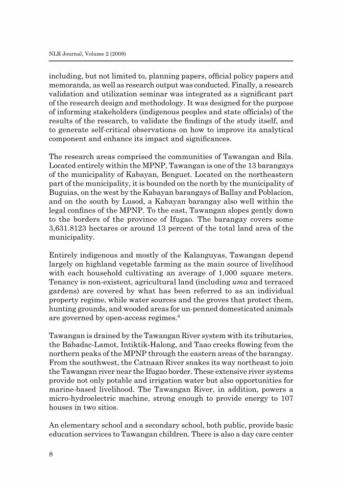
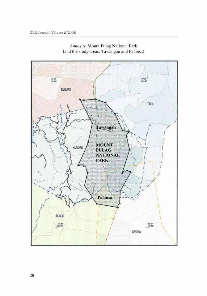
No studies, however, have as yet focused on the particularities of IP-state relations within the Philippine’s Mount Pulag. The highest mountain in Luzon and the second highest peak in th e country, it was declared a national park on February 20, 1987.1 Mount Pulag National Park (MPNP) has a total spread of around 11,560 hectares carved out of the municipalities of Bokod, Buguias and Kabayan in the province of Benguet, Tinok in Ifugao province, and Kayapa in Nueva Vizcaya (see Annex A for map of Mount Pulag and the study areas). Habitat to 528 documented plant species, 33 bird species, and several threatened mammals, the park is also ancestral home to the Kalanguya, Kankanaey, and Ibaloi ethnic groups who have long stood in ambivalent ground vis-à-vis the state on how and where their domains are located in the framework of national development. The resultant Mount Pulag social ecology, thus, may be regarded as a microcosm of state-society relations in the area of environmental management whose dynamics are ripe for research and analysis.
Indeed, within the park, IP-state tensions are frequent subtexts overlooked in environmental governance. Official records note, for instance that in 1983, the municipality of Buguias (which covers the park’s north and northwestern flanks) had around 20,165 hectares of forestlands but also that, 18 years later – and 14 years after the national park was established – forest cover in the municipality had decreased to 15,374 hectares, indicating an annual deforestation rate of 266 hectares per year (Buguias Municipal Planning and Development Office, 2001). Satellite images would show that the park itself had shrunk by 652 hectares in terms of forest cover in just ten years of its existence as a protected area with most of the deforestation concentrated in areas with

4
NLR Journal, Volume 2 (2008)
0-40% slopes some 1,700-2,200 meters above sea level and to its western and southern flanks (Turda et. al, 2004).
Yet, the state routinely points to the logging practices of mining corporations and the continuing practice of kaingin and uma, variants of slash and burn (or swidden) agriculture, by resident indigenous peoples as the major causes of deforestation (NIPAP, 2000). When logging was banned in 1987, the year the MPNP was established, this left the indigenous residents as convenient culprits. Indeed, the image is reinforced by the fact that, despite various strategies of reforestation and devolution policies to encourage people’s participation, local responses have fallen somewhere between ambivalence to outright refusal to be involved in forest conservation programs and the deliberate violation of environmental and forest conservation laws.2
The theoretical underpinnings of this research support the thesis that the state-society relations over forest resources rest on a dynamic interplay of culture, power, history, and human agency. In this vein, “the study of forest conservation becomes a cultural discourse that does not examine merely what is happening to the natural world but also meaningful actions and expressions of utterance, symbols, artifacts, texts of various kinds, and subjects that express themselves as well as others who interpret the expressions they produce and receive” (Gunawan, 2005). Such a discourse, thus, will consist not only of elucidations and expositions about forest conservation but also “to processes whereby understandings, interpretations, and meanings of the forest and how to manage it, are constituted and contested through oral and written communication and social practices” (ibid, p.5-6). For example, state environmental management policy could deviate from the official formulation (i.e., the policy statement or law) when it comes to policy implementation – or would never be implemented at all – resulting in policy gaps or issues that could be a venue for the “negotiation” of meaning and power among the parties involved.3
Such “negotiations” are often misperceived as failures in the implementation of environmental policies. They are conventionally reduced to a conflict of meanings over the use and access to resources which typically take the form of struggles between opposing interests that seek to assert their respective rights. A basic, although rather oversimplified, model of forest-related dispute is exemplified by the clash of definitions of forests either as a source of local livelihood or as
5
J.P.L. Andaya, et al. / Indigenous peoples, the state, and national parks
wilderness to be protected. This often springs from a binary opposition in which the protection of nature is held to preclude any productive use or vice versa (McCarthy, 2006). This zero-sum school of thought was what guided the establishment of the early American “natural parks.” It was also this type of an oversimplified conservation paradigm that characterized the establishment of MPNP in 1987, much to the consternation of several thousands of Kalanguya, Ibaloi, and Kankanaey families in the communities that fell within the newly demarcated territory.4
State-indigenous people clashes on the conservation issue are predicated on an uneven system of power relations. When indigenous groups debate with the State, they do so with a group of people with a culture of “State” but who possess the infrastructure to take their declared truths and apply them hegemonically. The resolution of indigenous and State claims over resources may be done through a dialogue based on the recognition that the state and an indigenous group constitute two cultures with contradictory philosophies. However, such intercultural dialogue pits a subaltern culture against a dominant hegemonic one. It, therefore, presupposes the workings of ideology and social control in the cultural politics of conservation. The ideology that seeks legitimation is the state’s conservationist environmental management policy. To ensure conformity to this ideology, a single-purpose bureaucracy is established and maintained, governed by “scientific forestry” and the “national interest” that entail the surveillance and policing of communities through a system of power relations that interacts, sometimes conflicts, with the beliefs and practices of the community. Conservation programs then may be seen as serving to sustain relations of power, usually at the expense of indigenous populations who have prior claims over the land. Often, the end result, as Ingold (1993) puts it, is to “legitimate the disempowerment of local people in the management of their environment.”
Foucault’s concept of governmentality is particularly instructive in the sociological treatment of the state as imbued with a culture of its own but one capable of imposing its ethos upon society and subsequently legitimating it as well.5 The modern state is singularly characterized by its attempt to make both the individual and the population objects of knowledge for government. In here, the goal is to achieve a strong state through the construction of knowledge rather than the imposition of law. Governing becomes the construction of certain truths and their circulation via normalizing and disciplining techniques, methods, discourses and
6
NLR Journal, Volume 2 (2008)
practices that extend beyond the state and stretch across the social body (Rutherford, 2007).
Specifically, then, governmentality is seen in the state’s “characteristic forms of visibility, ways of seeing and perceiving;” the production of regimes of truth which circumscribes how the world is apprehended; the ways in which particular technologies and experts are constructed and deployed; and the formation of particular kinds of bodies and subjects (Dean, 1999). It is through asking how these dimensions are iterated and reiterated that allows us to locate social, cultural, ecological and a host of other discourses and practices as power-infused relations rather than innocent politically-neutral endeavors. An analytical frame may even tackle five “dimensions to regimes of government” which one can read through programs of rule: particular epistemes or ways of thinking; the construction of some subjectivities and the disavowal of others; the picturing and apprehending of reality; strategic technologies of rule; and the values or ‘ethos’ of a particular government (Legg, 2005). Governmental management becomes dependent on the dissemination and internalization of these programs of rule among individual actors. The very process of governance ultimately creates a decentered network of self-regulating elements whose interests become integrated with those of the State.
In the ecological discourse, recent studies on governmentality generally focus on how state agencies, in combination with producers of expert knowledge, construct nature and the environment (see for example Rutherford, 2007; Agrawal, 2005; and Braun, 2000). This construction is viewed both in terms of the creation of an object of knowledge (i.e., the “environment”) and a sphere within which certain types of intervention and management are created and deployed to further the state’s larger aim of managing the lives of its constituents (i.e., “governance”). However, while state-IP engagements in governmentality and their various outcomes already form a significant part of the general environmental literature, the presumption appears to be that the state speaks with a single voice elucidating an environmental discourse that has evolved through time and employs a comprehensive system of technologies of governance that creates through the nomenclature of “empowerment,” subjects that regulate their own conduct towards the environment. The big question, however, is “Does it, really?”
7
J.P.L. Andaya, et al. / Indigenous peoples, the state, and national parks
This research shows how governmentality is constructed and actually played out at least in those parts of MPNP within the communities of Tawangan and Bila in the province of Benguet. It calls attention to an ontological divergence among state resource managers and at the same time outlines several mechanisms by which the affected indigenous populations negotiate the perceived rifts, not only on their terms as IPs but more importantly within the framework of rational choices bounded ultimately by the overwhelming pressures of market integration.
Research design and methods
The study on which this paper is based was programmed over the course of 12 months, from June 2007 to May 2008. Data was gathered according to the general principles of the Participatory Research Approach (PRAA) in social research (Chambers, 1992). Following the constructivist orientations of the study with its focus on the perceptions of the state and its various concerned instrumentalities toward forest resource use and management, a qualitative research design was employed with the following techniques of data gathering:
Focus group discussions (FGDs) were used as the primary method of data gathering with the household heads in the indigenous ilis (groups of houses) being the components of these discussions. The participants were purposively selected and the individuals and groups considered were those who directly experience the issue of concern and who the phenomenon being studied is likely to affect. Separate FGDs were also conducted with local leaders with council meetings transformed into such discussions upon prior arrangements.
Subsequently, in-depth interviews with purposively selected respondent families were conducted to gather specific data on indigenous practices, beliefs, values, and norms on forestry resource use still practiced within the study area. Through this method, narratives were produced which constituted the instrumental and instructive case studies for the whole research. The data gathered here not only served to strengthen findings gathered through the FGDs but also served to deepen and enrich the findings with specific account that served to facilitate understanding of the broader phenomenon being examined.
To complete the triangulation requirements of the qualitative methodology, an in-depth analysis of official periodic documentations
8
NLR Journal, Volume 2 (2008)
including, but not limited to, planning papers, official policy papers and memoranda, as well as research output was conducted. Finally, a research validation and utilization seminar was integrated as a significant part of the research design and methodology. It was designed for the purpose of informing stakeholders (indigenous peoples and state officials) of the results of the research, to validate the findings of the study itself, and to generate self-critical observations on how to improve its analytical component and enhance its impact and significances.
The research areas comprised the communities of Tawangan and Bila. Located entirely within the MPNP, Tawangan is one of the 13 barangays of the municipality of Kabayan, Benguet. Located on the northeastern part of the municipality, it is bounded on the north by the municipality of Buguias, on the west by the Kabayan barangays of Ballay and Poblacion, and on the south by Lusod, a Kabayan barangay also well within the legal confines of the MPNP. To the east, Tawangan slopes gently down to the borders of the province of Ifugao. The barangay covers some 3,631.8123 hectares or around 13 percent of the total land area of the municipality.
Entirely indigenous and mostly of the Kalanguyas, Tawangan depend largely on highland vegetable farming as the main source of livelihood with each household cultivating an average of 1,000 square meters. Tenancy is non-existent, agricultural land (including uma and terraced gardens) are covered by what has been referred to as an individual property regime, while water sources and the groves that protect them, hunting grounds, and wooded areas for un-penned domesticated animals are governed by open-access regimes.6
Tawangan is drained by the Tawangan River system with its tributaries, the Babadac-Lamot, Intiktik-Halong, and Taao creeks flowing from the northern peaks of the MPNP through the eastern areas of the barangay. From the southwest, the Catnaan River snakes its way northeast to join the Tawangan river near the Ifugao border. These extensive river systems provide not only potable and irrigation water but also opportunities for marine-based livelihood. The Tawangan River, in addition, powers a micro-hydroelectric machine, strong enough to provide energy to 107 houses in two sitios.
An elementary school and a secondary school, both public, provide basic education services to Tawangan children. There is also a day care center

9
J.P.L. Andaya, et al. / Indigenous peoples, the state, and national parks
for pre-school children. A barangay health station in Tawangan Proper sitio caters to the sick while the residents’ spiritual needs are answered by the Saint Paul Lutheran Church and the Union Spiritista which are both in Tawangan Proper. Communal concerns are addressed at meetings in the Tawangan Multi-purpose Hall.
Palansa, the second study area, is located at the northeastern corner of Bila, the northernmost barangay of the municipality of Bokod, Benguet. Of Bila, only the sitio of Palansa falls within the confines of MPNP.7
Palansa is barely a tenth of Tawangan, being approximately 290 hectares, of which barely a fourth is still forested. An elementary school and a Catholic chapel stand within the sitio. Some fifteen families, all migrants of two generations from Tinoc (Ifugao) and Buguias (Benguet), grow commercial vegetables and rice on terraces carved out of the slopes of the mountain. Popular as a hiking station for Mount Pulag climbers, it offers sparse but adequate rooming accommodations and a mini-grocery where food and water could be bought for the next trekking leg to the DENR forest ranger station at Babadak (already part of Kabayan), the last stop before the final push to the mountain peak. The agricultural terraces are also offered as tourism attractions with their quaint farmers’ sheds constructed in the traditional indigenous manner.
Findings and discussion
Within the above study areas, the state’s environmental policy framework for MPNP appears to stand on three pillars: the management of the protected area, agricultural development, and the security of indigenous ancestral domains. These governmental concerns are distributed among three main national institutions, namely: the Department of Environment and Natural Resources (DENR), the Department of Agrarian Reform (DAR), and the National Commission on Indigenous Peoples (NCIP), all supposedly as part of a comprehensive and integrated environmental management program that has evolved through the years and has moved from a purely Regalian-oriented approach to a community-based paradigm (Pulhin, 2002).
Yet, the study found that the current pursuit of the three-fold construction which necessarily frames and defines how the State carries out its environmental management plans results in serious discordances that create symbolic rifts that ultimately result in the steady erosion of the goals of sustainability in development. The findings of this research
10
NLR Journal, Volume 2 (2008)
show that three emergent divergences in governmentality operate within one territory, constructing that same territory in three different ways. Simultaneous with the others, each divergence seeks to present its own “regimes of truth” about land and resources and, through its own particular technologies of rule and management, endeavors to constitute its own type of self-governing subjects from among the same indigenous people. The findings strongly suggest that each of the three state instrumentalities involved operates along a divergent line of governmentality that differ with the others in all of Dean’s methodological dimensions. Consequently, these divergences present parallel yet conflictive alternatives to Tawangan and Palansa residents who respond by moving within the resultant opportunity structure in accordance with a rule of maximizing their chances for a better life.
DENR divergence
Despite recent legal developments framing the devolution of natural resource management from state centralism to indigenous populations (e.g. NIPAS law, IPRA) the DENR retains much of its overarching power to oversee the management of national parks, particularly MPNP. Indeed, respondents from both the Kabayan and Bokod municipal governments and the research communities themselves decry their lack of power to initiate and carry out developmental projects within the national park unless with permission from the Department. Tawangan and Palansa are part of “the Park” which is public domain and the DENR’s jurisdiction over it is well covered not only by Proclamation 75 but by other legal instrumentalities, including the NIPAS Act, the Revised Forestry Code, and the Mining Act of 1995.
Much of this residual power stems from the very nature of a national park-cum-protected area whose very proclamation reflects a particular approach to the environment – that of nature as under the protection and control of the state. Indeed, this very episteme of a park had been clearly demonstrated by the manner of its establishment. Proclamation 75 was issued without any consultation whatsoever with either the municipal governments whose jurisdictions were carved out for the park or the indigenous peoples who were rudely, although legally, reminded that their ancestral properties were owned by the state. It is also spelled out in the General Management Plan for the park (see Annex B for the MPNP-GMP areas), which details specific plans of conservation and protection but which limits community participation merely to the
11
J.P.L. Andaya, et al. / Indigenous peoples, the state, and national parks
validation of management schemas that are drafted beforehand. The core of the GMP is nestled in Program I of its prescriptive part: Ecosystem Management. It divides the whole park into management zones before the communities affected are consulted and then only for validation and explanation. Of Tawangan’s total land area, only around 174 hectares (4.79%) is mandated as agricultural zone while reserving around 2,959 hectares (81.48%) as protected forest under the NIPAS law. It then “ensure(s) that the LGUs and agencies concerned adopt the policies on the management zoning system” (NIPAP, 2000).
In this governmentality divergence, the park and all resources within it are owned by the State under the original Regalian worldview. The disposition and use of land and other resources are determined by the State and while the GMP outlines provisions to “ensure sustainable resource utilization based on indigenous systems of management,” such utilization is limited to species of wildlife and selected flora (NIPAP, 2000). The utilization of land is conspicuous only by its absence and the issue of ancestral domains, while mentioned in the descriptive part of the GMP, does not find light in the articles on prescription.
DAR divergence
The Department of Agrarian Reform’s mandate is to give land to the landless. This rather simplified expression already reflects a “characteristic form of visibility,” different from that of the DENR. The land and other resources may be owned by the state but these may be alienated through ways and means prescribed by the disposing instrumentality. For the DAR, Tawangan is an Agrarian Reform Community (ARC). Within it, as well as in other DAR ARCs8, resident-farmers are given the option to be “awarded” the lands they cultivate. Thus, for example, in 1996, four “mother” Certificates of Land Ownership Awards (CLOAs) covering an area of 1,020 hectares or slightly over half of the Tawangan ARC’s total land area of 2,020 hectares were given to 401 beneficiaries. A Memorandum of Agreement (MOA) between the DAR and the DENR in which the latter agreed to transfer land management authority supposedly ironed out jurisdictional inconsistencies. However, four years later, the MPNP-GMP was made. No mention was made of the fact that between the ARC and NIPAS delineations, some 25.86% (around 939 hectares) of Tawangan fell both within the Agricultural Reform Community and the NIPAS protected forest zone. The same MPNP-GMP delineated Palansa as a strict protection zone.
12
NLR Journal, Volume 2 (2008)
Indeed, the DAR governmentality operable within this zone overlap in Tawangan is based on the vision of “equitable land ownership with empowered ARBs” and supports an agricultural structure complete with a five-year development plan that spells out details for farm and non-farm projects; the building, strengthening, and sustainability of indigenous and sectoral organizations; provision of basic social services like health and education; and, in what would make the DENR shudder in its conservationist boots, support infrastructure including irrigation, storage facilities and loading platforms, power generation, and transportation facilities that improve “accessibility” – with budgetary outlays and timeframes for implementation. To date, the Department has extended considerable financial assistance to the beneficiaries through their cooperative and has facilitated numerous training programs on micro-industries and other livelihood projects while regarding Proclamation 75 merely as a “constraint” to expanded agricultural activities (Department of Agrarian Reform - CAR, 2000). To date also, however, the DENR has resisted attempts to implement the above plans by refusing to issue Environmental Compliance Certificates (ECCs) in their support, justifying this action by their mandate to protect the park especially from infrastructure projects like road-laying and improvement that could lead to the conversion of forests to agricultural areas.
NCIP divergence
The governmentality of the National Commission on Indigenous Peoples (NCIP) may well be the complete antinomy of those of the DENR and the DAR. Notwithstanding criticisms from militant sectors, the NCIP represents what has been called as “a paradigm shift” in state environmental management policy (Prill-Brett, 2003). That there is no such shift is underscored by the fact that the NCIP mandate runs parallel – and did not substitute for – those of the DENR and the DAR. Indeed, various formal tripartite engagements and memoranda have been entered into by the three governmental agencies to delineate and specify their respective responsibilities in these most recent projects, the institutionalization of ancestral lands and domains of the indigenous peoples of the Cordillera.
The Indigenous Peoples’ Rights Act (R.A. 8371) has been referred to as a “landmark” law and indeed, it had its promises (Molintas, 2004). With its provisions on the recognition of IP rights over their ancestral

13
J.P.L. Andaya, et al. / Indigenous peoples, the state, and national parks
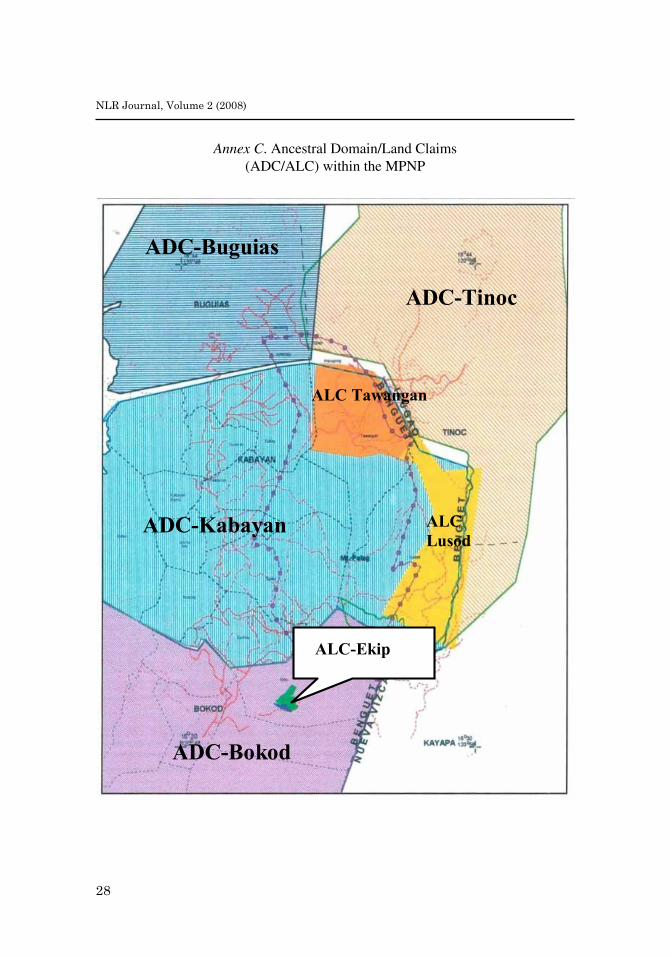
lands and domains, including those lands that have been inalienable under the Revised Forestry Code (P.D. 705), the IPRA is declaring ipso facto that such lands are owned not by the state but by the indigenous populations that have historical and customary rights over them. In this divergent governmentality, Tawangan for example comprises ancestral lands, where an indigenous people’s claim covering 22,039.07 hectares had been filed and a certificate ascertaining thereto has been issued as early as 1992. This ancestral land is part of the Kabayan ancestral domain, whose people’s claim over 27,252 hectares was certified in 1998. The Bokod ancestral domain application covers 42,946 hectares while that of Buguias is spread out over 18,185 hectares. (See Annex C for ancestral domain/land claims with the MPNP.) In contrast with DENR’s terra nullius governmentality divergence or DAR’s land-award divergence, the NCIP maintains that the very process of perfecting the community’s ancestral land title and Kabayan’s ancestral domain title is but a process of verification and formalization of the a priori possession and ownership by the people’s land and the resources within it.
Consequently, the recognition of the indigenousness of the land underscores what could be interpreted as the supreme confidence of the state in the capabilities of indigenous knowledge, systems, and practices in ecological conservation and the protection of biodiversity. Thus, eschewing the direct involvement of formal state institutions, IPs are mandated to organize themselves into formal organizations that, after due accreditation and recognition by the NCIP, are consequently empowered to draft Ancestral Domain Sustainable Development Protection Plans (ADSDPP) which shall serve as their primary instruments for carrying out their vision for their domains. These, the Kalanguya, Ibaloi and Kankanaey of the IPOs Onjon ni Kasikuran Shi Kabayan (ONKASKA) of Kabayan and the Shakilan I-kolos of Bokod, separately drafted for their respective domains in mid-2006.

14
NLR Journal, Volume 2 (2008)
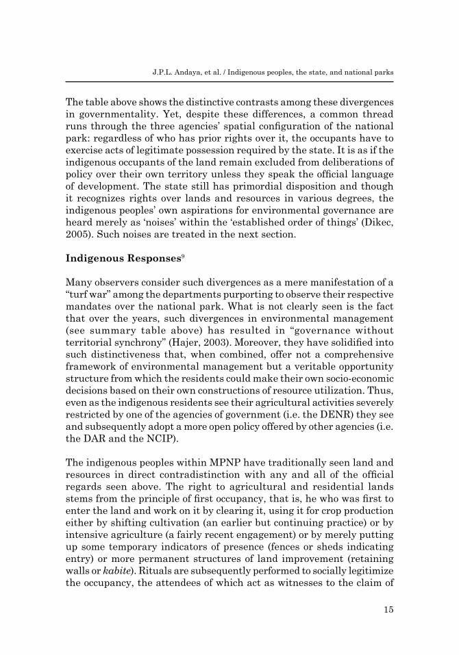
1. Characteristic forms of visibility
2. Regimes of truth
3. Employment of technologies and/or instruments
4. Formation of particular bodies and subjects
The National Integrated Protected Area Programme (NIPAP), the PASU, PASUS, park rangers, the PAMB
The Regalian Doctrine prevails. All national parks are inalienable protected areas and ecological sanctuaries subject to conservation and preservation. The MPNP is one such park.
E.O. No. 50, NIPAS Law, Revised Forestry Code, Mining Act of 1995
Mount Pulag National Park IP conservationists and protectors
DIMENSIONS OF GOVERN-MENTALITY
EMERGENT DIVERGENCES IN GOVERNMENTALITY
DENR DAR NCIPAgrarian Reform field workers
The ARC is alienable under the social justice provisions of the Philippine Constitution particularly on the right of the people to own the lands they till. The Tawangan ARC, in particular, even if located within a national park, is subject to alienation under the Comprehensive Agrarian Reform Law of 1988.
The Comprehensive Agrarian Reform Law of 1988.
Tawangan and Bila Agrarian Reform Communities (ARCs)
NCIP field coordinators
The area is the ancestral domain of the indigenous peoples of Kabayan and Bokod. Thus, it is not the state’s disposition to grant but only to recognize the existence of such domains as ancestral and award official titles thereto subject only to the fulfillment of procedural requirements.
The Indigenous Peoples’ Rights Act of 1997
Kabayan and Bokod IPs self-determinant in their respective ancestral domains
15
J.P.L. Andaya, et al. / Indigenous peoples, the state, and national parks
The table above shows the distinctive contrasts among these divergences in governmentality. Yet, despite these differences, a common thread runs through the three agencies’ spatial configuration of the national park: regardless of who has prior rights over it, the occupants have to exercise acts of legitimate possession required by the state. It is as if the indigenous occupants of the land remain excluded from deliberations of policy over their own territory unless they speak the official language of development. The state still has primordial disposition and though it recognizes rights over lands and resources in various degrees, the indigenous peoples’ own aspirations for environmental governance are heard merely as ‘noises’ within the ‘established order of things’ (Dikec, 2005). Such noises are treated in the next section.
Indigenous Responses9
Many observers consider such divergences as a mere manifestation of a “turf war” among the departments purporting to observe their respective mandates over the national park. What is not clearly seen is the fact that over the years, such divergences in environmental management (see summary table above) has resulted in “governance without territorial synchrony” (Hajer, 2003). Moreover, they have solidified into such distinctiveness that, when combined, offer not a comprehensive framework of environmental management but a veritable opportunity structure from which the residents could make their own socio-economic decisions based on their own constructions of resource utilization. Thus, even as the indigenous residents see their agricultural activities severely restricted by one of the agencies of government (i.e. the DENR) they see and subsequently adopt a more open policy offered by other agencies (i.e. the DAR and the NCIP).
The indigenous peoples within MPNP have traditionally seen land and resources in direct contradistinction with any and all of the official regards seen above. The right to agricultural and residential lands stems from the principle of first occupancy, that is, he who was first to enter the land and work on it by clearing it, using it for crop production either by shifting cultivation (an earlier but continuing practice) or by intensive agriculture (a fairly recent engagement) or by merely putting up some temporary indicators of presence (fences or sheds indicating entry) or more permanent structures of land improvement (retaining walls or kabite). Rituals are subsequently performed to socially legitimize the occupancy, the attendees of which act as witnesses to the claim of

16
NLR Journal, Volume 2 (2008)
ownership in cases of dispute and the kinaba (lands cleared for shifting cultivation) may now be subject to tawid or succession. Such non-legal but socially binding claims still persist in many areas of MPNP although, in keeping with state requirements, most of the residents have filed tax declarations over their properties or have applied for (and were granted) land patents for these.
Such lands are usually located at the lower elevations and rolling hills of the park. At higher elevations are the dayahan (characterized by grasslands, fruit trees, and a few scattered pine, where pigs are allowed to roam and feed), the duangan (literally hunting grounds, characterized by thicker growths of pine and other perennial wood where deer and bakawas could still be found), and the pi-yaw (sacred ground, located at the upper reaches of the mountains, considered as forest sanctuaries and which include the grasslands at the summit of Mount Pulag, itself, home of the ancestral spirits of the Ibaloi). The dayahan and the duangan are communal not in the sense of property rights but mainly of usufruct. Trees and bamboo may be cut for housing, fruit and honey gathered for the table, and ugsa and bakawas shot or trapped for meat. Improvements like footpaths and reforestation may be made either through gamal (cooperative work) or individual effort although the latter does not contribute to the ripening of an individual claim. But water sources may not be defiled, claimed, or its vicinity occupied or cultivated. The pi-yaw may never be touched, its resources only to be protected such that even the gathering of firewood is prohibited.
These use rules as well as the communal-personal property limits are maintained via oral tradition and transmitted from generation to generation through balakad or pammagbaga (advises). Conflicts over land uses and proprietary claims are amicably settled in the tongtongan presided over by elders, with resolutions and agreements sealed by ritual. Even now, informants say, dust gathers at the office of the Lupong Tagapamayapa where conflicts are supposed to be legally resolved.
Up to the middle of the 1990s, crops traditionally grown within the kinaba had been limited to rootcrops, vegetables, and rice mainly for household consumption. Quite a few families produced commercial vegetables but limited their output (and, thus, the area planted), constrained mainly by the relative isolation of the production areas (i.e., the vegetables have to be carried on foot to Tinoc where they were sold to traders) and only partially by the lack of financial capitalization. This changed when the

17
J.P.L. Andaya, et al. / Indigenous peoples, the state, and national parks
provincial trail from Kabayan to Tinoc, with Tawangan at mid-transit, was widened and improved sometime in 1997, in coincidence but most likely not in coordination with two important developments, one local and the other national in scope and significance: the establishment of the Tawangan ARC a year earlier and the enactment of the Indigenous People’s Rights Act in the very same year. It was at around this time that commercial vegetable production suddenly was given a tremendous boost. Migrants from Tinoc and Buguias started the trend but the kinaba started its transformation from a subsistence unit to a commercialized production area. Carrot, potato, cabbage, cauliflower, and garden pea competed with the traditional rice and camote crops, straining the limits of the traditional swidden plots and agricultural expansion began, first to the grasslands and later to the outer fringes of the woodlands. Spurred by the commercial successes of Buguias to the north and Atok to the west in vegetable production, Ballay (the Kabayan barangay at the western terminus of the Kabayan-Tinoc road) became a full-fledged commercial vegetable barangay by the onset of the new millennium and Tawangan was poised to follow suit.
The physical integration of the production areas to municipal and provincial arteries did not only transform the agricultural economic base but also the social infrastructure of production as well. Not only did government financial institutions become more accessible but the ARC also put up its own lending cooperative and “financier-suppliers” from Baguio and La Trinidad extended their networks to the area including packages for marketing and conveyance. Mount Pulag vegetables now reached not only Tinoc and Baguio but also the markets of Nueva Vizcaya and beyond to Manila. It was at this juncture, when the previously subsistence agricultural economies within the park were being inexorably but steadily made adjuncts of the national commercial agricultural economy that farmers began to find the mandate of the DENR over the park, laid down ten years before the commercial transformations were accelerated, increasingly repressive. By the year 2000, however, these indigenous farmers were already facing the opportunity structure presented by the divergences in environmental management governmentality and were rationally choosing the most beneficial arrangements they could derive from it. The research found the following response patterns practiced within the park alongside the continuing engagement in commercial agricultural activities. In these, they find support of varying degrees from their elected representatives in the local government.

18
NLR Journal, Volume 2 (2008)
Multiple opportunity engagements. Mount Pulag residents take advantage of all income generating opportunities. For example, during the summer, when tourism is at its peak, they offer their services as guides. Many farmers are members of tourist guide organizations accredited by the DENR and it is not a rare occasion that tourist guides are hired right off their own gardens as the tourists pass by.
Redefining of the sustainability discourse. Farmers argue that commercial farming is more environmentally sustainable than the kinaba system. The kinaba is characterized by shifting cultivation and covers an ever expanding area of land as farmers attempt to increase production. Clearing is often done by the burning of grasslands which sometimes result in forest fires. In contrast, commercial vegetable farming is intensive agriculture where existing kinaba areas are improved and made more productive through the employment of chemical inputs. No expansion is claimed as the existing kinaba are themselves improved for increased production.
Focusing on jurisdictional ambiguities. Farmers often redirect attention away from their farming activities to the inability of the government to clearly delineate the boundaries of the national park. Due to this, they claim innocent transgression and say that they will respect national restrictions when park limits are clearly specified and marked out.
Shifting culpabilities. Farmers squarely put the blame for encroachments on strictly protected zones to migrants or farmers from other municipalities (e.g. Buguias or Tinoc). Indeed, there are evidences to support this claim as authorities later found out.
The “turnover” argument. Aside from pointing out the entry of encroaching farmers from other municipalities, resident farmers also point out the failure of the national government to come out with a unified and comprehensive policy on resource use and utilization within the confines of the national park. They claim that such a rational and comprehensive policy that will benefit farmers and at the same time prevent ecological destruction can be formulated once the management of the park is turned over to the local government (i.e. Kabayan) which is more attuned to the needs and problems of the people but at the same time is also duly concerned with environmental protection and conservation.

19
J.P.L. Andaya, et al. / Indigenous peoples, the state, and national parks
Indigeneity as the ultimate paradigm of sustainability. Farmers inevitably turn to their Ancestral Domain Sustainable Development Protection Plan (ADSDPP) when asked what assurance they could give of ecological protection alongside their continued engagements in commercial vegetable agriculture. The ADSDPP becomes the ultimate argument for sustainability and indigeneity, thus, becomes the final requisite for ecological balance and environmentally sound resource management. This is so despite the fact that within the area, there has never been the concept of an “ancestral domain” and, thus, no recourse can be taken to culture and tradition as to how such domain could be delineated, the activities within controlled or otherwise regulated, and the administration thereof established and made operational.
Conclusions: Toward a framework for resource management in a national park
The challenge for policy-makers is to promote protection and conservation of biodiversity while providing alternate, sustainable livelihoods for local people. Yet, the results of the study strongly indicate that while the state continues to operate on divergent levels of governmentality, environmental management policy at least in the Mount Pulag National Park will remain bogged down in bureaucratic inertia.
What immediately suggests itself is a process of institutional integration whereby the three agencies would work out a singular approach to the management of a national park which, by historical and structural processes, does not fit conventional models. This approach would have to consider some inescapable realities: that there are communities within the park that have been there prior to its establishment; that these communities are agricultural; that the agricultural economies are caught up in a commercializing trend that is regional in scope and global in character; that agricultural expansion now threatens the forests and biodiversity in the park; and that Mount Pulag is not only a biome of biological diversity, some of whose species are endemic but also the watershed to a river system that benefits not only the southern part of the Cordillera but the vast croplands of Pangasinan. All governmentality divergences recognize these realities.
The needs can also be summarized, thus: that there is a need to stop agricultural expansion but not necessarily agricultural development; that there is a need to preserve, conserve, and develop what forest cover
20
NLR Journal, Volume 2 (2008)
remains but that forest conservation and development need not mean also the reduction of what is necessary to provide communities with the resources they need for self-development; and that the communities within the park need not only to be involved in any developmental scenario but also to be self-determining in their own capacities. These are also without contention among the agencies involved.
With these commonalities, the various stakeholders (DENR, DAR, NCIP, IP, and LGU) can come together and work out a single and shared way of perceiving and construing the nature of Mount Pulag National Park in accordance with the historical and structural necessities that created it. An existing land use map has to be drawn depicting faithfully and without prejudice the actual lines of use demarcation and a proposed land use map generated that will resolve overlapping representations and will guide future park and resource management through a single rationality. Then these have to be marked down clearly on the ground with signages and or monuments. Such a rational communicative action process is indispensable as it can now, after coding their geography, democratically agree on the parameters of activities allowable within the coded zones. Rewards revolving around developmental incentives, including funding for infrastructure, within agricultural areas could even be institutionalized for services rendered individually or collectively within strict protection areas.
One caveat needs to be pointed out, however. Among the multiple governmentalities, attempts to incorporate “local participation” as a necessary component of their divergent programs have been always predicated on “information dissemination campaigns” and various types of “training.” Behind the official statements, therefore, of integrating indigeneity into the various governmentalities, lies a presumption of state superiority, if not dominance, in power relations. It implies that the indigenous are to be included in ecological agenda designed and authorized by instrumentalities external to the indigenous, a pattern that may indicate a kind of an exclusion by bureaucratic inclusion. The role of the state is still privileged at the expense of genuine indigenous participation. At the base of it all is the tacit perception of the indigenous as ignorant and backward while maintaining the romantic myth of the “noble savage, living in harmony with nature and the universe.”
Assessments of the responses of the indigenous peoples within the study area indicate the trend that while confusion is articulated as a
21
J.P.L. Andaya, et al. / Indigenous peoples, the state, and national parks
consequence of programmed divergences, the communities – aided by an astute political leadership that straddles both the local government as well as the civil society sector – are rationally weighing alternative opportunities for individual as well as group advancement within an opportunity structure created precisely by the multiple governmentalities. Rational choice explains their ultimate responses as IPOs, communities, or individuals even as they continue to grapple with their day-to-day concerns which they know are tied in with provincial and national developments such as importation and the politics of the vegetable trade. Whether they (we) like it or not, the invisible hand of the market has grasped the life of the Mount Pulag farmer firmly and inexorably.
With all the bureaucratic entanglements the multiple governmentalities have spawned, however, opportunities for a genuine IP-based environmental program have arisen. The mechanics of devolution have been set in place and popular organizations have been continually pushing outwards the boundaries of the public sphere. A clamor has been raised for the crafting of a comprehensive legislation on people-based ecologies to codify what have hitherto been mere executive issuances on participatory forestry. Perhaps this might be an opportunity for the state to formulate a single governmentality on the Philippine human ecology with all agencies and communities around the table not as subalterns and subordinates but as equals.
Notes
This research project was conducted under the auspices of Saint Louis University (SLU) and the Vlaamse Interuniversitaire Raad – Philippines Institutional University Cooperation (VLIR-PIUC). A part of the findings, entitled “Divergent Programs, Programmed Divergence: Thematic Rifts in the State Management of a National Park,” has been presented by the main proponent, Joseph Porfirio L. Andaya, in the 1st International Conference on Cordillera Studies held at the University of the Philippines Baguio held on February 7-9, 2008.
1 Presidential Proclamation Numbered 75, series of 1987
2 In 2007, the Benguet Provincial Environment and Natural Resources Office (PENRO) declared as hot spots two areas within MPNP where an investigation showed deliberate bulldozing of trees. Three separate patches of land, with a total area of 7.65 hectares, had been cleared and terraced and the PENRO had confiscated 4,057 board feet of illegally cut pine trees (Carino, 2007). At least
22
NLR Journal, Volume 2 (2008)
100 hectares of mossy forest had disappeared in these areas since 1987, with some 20 hectares bulldozed shortly before the May 2007 elections. (Allad-iw, 2007). Potentially more politically conflagratory situations are not beyond contemplation. In 1998, in Lusod, Kabayan, locals attacked a park ranger of the National Integrated Protected Areas Programme (NIPAP), almost hacking him to death, when he tried to prevent residents from cutting a tree for housing. Earlier that year, NIPAP staff had planted trees in Kalanguya swidden farms without getting the communities’ approval. A barangay councilman reportedly said, “They trampled on our crops. In retaliation, the people uprooted thousands of seedlings planted by NIPAP” (Bengwayan, 2000).
3 Such negotiations, of course, could either be in formal dialogue or conducted on the ground, that is, in the reactive-assertive activities done both by the state and the indigenous population as a consequence of their respective interpretations of the policy formulation.
4 Included in the newly established park were eight barangays of Kabayan, two barangays of Bokod, and other barangays of Buguias, Kayapa, and Tinoc.
5 On the genealogy of governmentality, see Lemke, 2001, The Birth of Biopolitics: Michel Foucault’s lecture at the College de France on neo-liberal governmentality, Economy and Society 30(2), 190-207.
6 For the definitive discussion on indigenous property regimes in the Cordillera, see June Prill-Brett, “Resource tenure and ancestral domain considerations: Their importance to a CBNRM research agenda,” Paper prepared for the Community-Based Natural Resource Management Workshop, May 12-16th, 1997, at the Hue University of Agriculture and Forestry, Hue, Vietnam.
7 Ekip, at the northeastern portion of Bokod, is within the confines of the MPNP but was not chosen as one of the study areas due to logistic constraints. However, discussions with the respondents from Palansa and the municipal administration seem to indicate close parallels between Ekip and the study areas in terms of its politics of ecology.
8 Palansa, the other research area, is part of barangay Bila, which, together with barangays Daclan, Tikey, Ekip, and Karao, form the Bokod Agrarian Reform Community. Palansa and Ekip are located within the MPNP.
9 Except when specifically cited, direct quotes and all information contained in this section are from the Focus Group Discussions with indigenous peoples groups within the study areas.

23
J.P.L. Andaya, et al. / Indigenous peoples, the state, and national parks
References
Abaya, E. C. (1994). Cultural politics of disease control: State-community relations in the struggles against malaria in the Philippines.
Agrawal, A. (2005). Environmentality: Technologies of government and the making of subjects. Durham: Duke University Press.
Allad-iw, A. (2007, August 12). News. Retrieved November 12, 2007, from Bulatlat: http://www.bulatlat.com/2007/08
Bautista, G. (1994). Natural resources, economic development and the state: The Philippine experience. Singapore: Institute of Southeast Asian Studies.
Bengwayan, M. (2000, October 20). Archives. Retrieved December 28, 2007, from Forest Portection Portal: http://forests.org/archives/asia/phincomm.htm
Braun, B. (2000). Producing vertical territory: Geology and governmentality in late Victorian Canada. Ecumene, 7 (1).
Brown, E. (1996). Tribal displacement, deculturation and impoverishment. In J. Eder, & J. Fernandez, Palawan at the crossroads: Development and environment on a Philippine frontier (pp. 97-110). Quezon City: Ateneo de Manila University Press.
Buckles, D. a. (1999). Conflict and collaboration in natural resource management. In D. Buckles, Cultivating peace: Conflict and collaboration in natural resource management. IDRC/World Bank.
Buguias Municipal Planning and Development Office. (2001). Comprehensive Land Use Plan of the Municipality of Buguias, Benguet (2003-2011). Buguias, Benguet.
Carino, D. (2007, June 25). Rampant tree cutting threatens wildlife on Mount Pulag. Philippine Daily Inquirer, p. 12.
Chambers, R. (1992). Rural Appraisal: Rapid, relaxed and participatory. Sussex: Institute of Development Studies.
Cruz, G., Diaz, V., Follosco, A., Mendoza, L., Rood, S., & Tapang, B. J. (undated). Agricultural commercialization in the sustainable development of the Cordillera.
Dean, M. (1999). Governmentality: Power and rule in modern society. London: Sage.

24
NLR Journal, Volume 2 (2008)
Department of Agrarian Reform - CAR. (2000). The Tawangan Agrarian Reform Community Development Plan. La Trinidad: Department of Agrarian Reform - CAR.
Dikec, M. (2005). Space, politics and the political. Society and Space, 171-188.
Guiang, E., Borlagdan, S., & Pulhin, J. (2001). Community-based forest management in the Philippines: A preliminary assessment. Quezon City: Ateneo de Manila University.
Gunawan, R. (2005). Power, meaning, and forest conservation: The dynamics of state-society relations. In F. J. Aguilar, & M. A. Uson, Control and conflict in the uplands: Ethnic communities, resources, and the state in Indonesia, the Philippines, and Vietnam (pp. 23-59). Quezon City: Ateneo de Manila University Press.
Hajer, M. (2003). Policy without polity? Policy analysis and the institutional void. Policy Sciences , 36, 175-190.
Hirsch, P., Phanvilay, K., & Tubtim, K. (1999). Nam Ngum Lao PDR: Community-based natural resource management and conflicts over watershed resources. In D. Buckles, Cultivating peace: Conflict and collaboration in natural resource management (pp. 1-30). IDRC/World Bank.
Ingold, T. (1993). Globes and Spheres: The typology of environmentalism. In K. Milton, Environmentalism: The view from anthropology (pp. 31-42). London: Routledge.
Legg, S. (2005). Foucault’s population geographies: classifications, biopolitics and governmental spaces. Population, Space and Place, 11, 137-56.
Lemke, T. (2001). ‘The birth of biopolitics: Michel Foucault’s lecture at the College de France on neo-liberal governmentality. Economy and Society, 30 (2), 190-207.
Lynch, O., & Talbot, K. (1995). Balancing acts: community based forestry management in Asia and the Pacific. Washington D.C.: World Resources Institute.
McCarthy, J. (2006). Neoliberalism and the politics of alternatives: Community forestry in British Columbia and the United States. Annals of the Association of American Geographers, 96 (1), 84-104.
25
J.P.L. Andaya, et al. / Indigenous peoples, the state, and national parks
Molintas, J. M. (2004). The Philippine Indigenous Peoples’ Struggle for Land and Life: Challenging Legal Texts. Arizona Journal of International and Comparative Law, 21 (1), 269-306.
NIPAP. (2000). Mount Pulag General Management Plan. DENR: National Integrated Protected Areas Programme.
Peluso, N. L. (1992). Rich forests, poor people: Resource control and resistance in Java. Los Angeles: University of California Press.
Prill-Brett, J. (2003). Changes in indigenous common property regimes and development policies in Northern Philippines. RCSD International Conference on the Politics of the Commons. Chiang Mai, Thailand.
Pulhin, J. (2002). Trends in forest policy of the Philippines. Policy Trend Report, 29-41.
Resurreccion, B., & Sajor, E. (1998). Beyond dichotomies: Dissecting power in environmental issues. In K. Gaerlan, People, power, and resources in everyday life: Critical essays on the politics of environment in the Philippines (pp. 13-54). Quezon City: Institute for Popular Democracy.
Richards, M. (1997). Common property resource institutions and forest management in Latin America. Development and Change, 28 (1), 95-117.
Rutherford, S. (2007). Green governmentality: Insights and opportunities in the study of nature’s rule. Progress in Human Geography, 31 (3), 291-307.
Turda et. al, A. (2004). Analysis of spatial and temporal change of forest cover in the Mount Pulag National Park, Philippines. FOSS/GRASS Users’ Conference. Bangkok, Thailand.
26
NLR Journal, Volume 2 (2008)
Annex A: Mount Pulag National Park (and the study areas: Tawangan and Palansa)
Figure 1: Mount Pulag National Park (and the study areas: Tawangan and Palansa)
Tawangan
MOUNT PULAG NATIONAL PARK
Palansa

27
J.P.L. Andaya, et al. / Indigenous peoples, the state, and national parks
Annex B. The MPNP-GMP Areas
28
NLR Journal, Volume 2 (2008)
Figure 3. Ancestral Domain/Land Claims (ADC/ALC) within the MPNP
ALC Tawangan
ADC-Tinoc
ADC-Buguias
ALC Lusod
ALC-Ekip
ADC-Bokod
ADC-Kabayan
Annex C. Ancestral Domain/Land Claims(ADC/ALC) within the MPNP