Embed Size (px)
Citation preview

Summary---Little Missouri River above Long Creek near Albert Pike, Arkansas Page 1
Indirect Measurement Summary
Little Missouri River above Long Creek near Albert Pike, Arkansas Ouachita River Basin
Miscellaneous Site Q= 28,800 ft3/s
Flood of June 11, 2010
Type of measurement: Slope Area Location of site: A miscellaneous site above the inflow of Long Creek on the Little Missouri River. Lat N 34˚23’21”, Long W 93˚52’43” This site was selected because it was a straight converging reach upstream of Long Creek. This reach runs almost due south. A low water bridge crosses the river approximately 4300 feet downstream of the indirect measurement location. Long Creek comes into Little Missouri River on the right bank approximately 4860 ft downstream. A constriction occurs 800 ft downstream of the indirect measurement site as the valley walls narrow from a highly resistant layer of novaculite. Surveys were also conducted in the area of the constriction to check if critical depth computations for flow can be made in this constricted area. The site is Approximately 5.72 miles northwest of Langley, Arkansas, 12.08 miles southwest of Norman, Arkansas, 14.9 miles west of Caddo Gap, Arkansas, and 31.1 miles east of Cove, Arkansas. Survey of site: Site was selected on Tuesday June 15, 2010 by Robert Holmes during reconnaissance of the flood area. High water marks were flagged on the evening of June 15, 2010 by Robert Holmes. A survey commenced on the morning of June 16, 2010 by Ferrell Killian, Aaron Pugh, and Jonathon Gillip. The initial occupation point (OC-1)was a pin driven into the gravel bar at the upstream cross section. An arbitrary Northing/Easting of 5000/5000 was assumed with an elevation of 100. The azimuth was established with a compass bearing of magnetic north. After the point was vacated by the total station survey, a Trimble GPS unit was setup to occupy the point for several hours to establish the horizontal (NAD83) and vertical position (NAVD88) of each survey point. The survey was continued downstream of the indirect measurement site in order to capture additional high water marks along the river as well as the channel geometry of the constricted area. The Survey of the indirect measurement site was made using a Sokkia Set 3c 3-second total station, serial number 23110. The survey plots off from the DRG as the result of the original survey azimuth not starting at true north. XS-4 is the channel (and floodplain) cross section at the constriction.

Summary
Dischargmiscellan Drainag Unit Dis(Region
y---Little Miss
ge and Gageneous site.
e area: 18.2
charge: 18) is below,
souri River ab
e Height: 2
2 mi2 as det
,580 cfs/mi2
with this flo
bove Long Cr
Cross Se
8,800 cfs. N
termined by
. Crippen anood approxim
reek near Alb
ection Locat
No Gage Hei
Albert Rea o
nd Bue (197mately plotte
bert Pike, Ark
tions
ight was det
of the USGS
77) envelopeed.
kansas
termined as t
S using NHD
e curve for th
P
this is a
D Plus.
his region
Page 2

Summary
Nature ofell in a vthe USGthe rates few minu Field conthrough toverbankincluded subsectiocross sec See the freach. M4H01773M4H01776
M4H01799M4H01800M4H0180
y---Little Miss
of flood: Thvery short peS streamgagof rise from
utes. The Ou
nditions: Ththe reach. Ek which consthe two ban
on of the totaction, and XS
following vid
3.MP4---Little6.MP4---Little
XS9.MP4—Little0.MP4—Little1.MP4---Little
souri River ab
his flood waseriod of timege 10 miles d
m survivors inuachita mou
he indirect reEach of the thsists of the g
nk areas withal cross sectiS3 is the mo
deo clips to v
Missouri Rive Missouri Rive1 (most upstrea Missouri Rive Missouri Rive Missouri Rive
bove Long Cr
s a flash flooe starting jusdownstream n the Albert untains are a
each is fairlyhree cross segravel road bh the trees, anion. XS1 is st downstrea
view the cha
er above Long er above Long am XSECT) er above Long er above Long er above Long
reek near Alb
od of extremst before or awere as muPike Campgknown “floo
y straight witections was sbed and left vnd 3) the rigthe most ups
am cross sec
annel and flo
Creek at the InCreek at the in
Creek at the inCreek at indireCreek at Indire
bert Pike, Ark
me nature. Aat midnight ouch as 8 ft/hoground indicod hotspot”
th nearly unisubdivided invalley wall, tght overbankstream cross
ction.
oodplain con
ndirect reach. ndirect reach.
ndirect reach. ect reach. Maiect reach. Left
kansas
s much as 7 on June 10. our. Anecdoate as much in the United
iform boundnto 3 subsecthe 2) main
k, which is a s section, XS
nditions for t
This is right ovThis is right ov
Left overbank in channel at Xft overbank at X
P
inches of raRates of rise
otal accountsas 3 feet in
d States.
dary roughnections: 1) thchannel, whpanhandle
S2 is the mid
the indirect
verbank of XSverbank upstre
along road at XXS1 XS 3.
Page 3
ain e at s of a
ess e left
hich
ddle
3 eam of
XS1

Summary
The left othe gravewall that judgment
The mainedge andbased on
y---Little Miss
overbank wael road with is the left edt.
At XS1
n channel cod willows/bru engineering
Approxima
HWM flow
souri River ab
as estimated a small amodge of the le
1 looking do
onsists of graush on right g judgment a
ate
w line
bove Long Cr
to have an nunt of trees/
eft overbank.
ownstream th
avel/cobble bedge. N val
and weighted
A
is
reek near Alb
n value of 0./brush on the. The estima
hrough left o
bed in the malue assignedd composite
Rig
sub
tre
Approximate l
s just beyond
bert Pike, Ark
039. The lee right edge ate of n=0.03
overbank alo
ain channel d to main cha
n.
ght edge of le
bsection. Som
ees/brush.
location of XS
car
kansas
eft overbank and grass on39 is based o
ong gravel ro
with trees/bannel subsec
ft overbank
me influence
S 3
P
is made up on the left valon engineeri
oad.
rush on the lction was 0.0
of
Page 4
of lley ing
left 058

Summary
y---Little Misssouri River abbove Long Cr
XS1 look
XS1 loo
reek near Alb
king downst
oking upstre
bert Pike, Ark
tream
eam
kansas
PPage 5

Summary
At XS
Right oveengineeri
In right
y---Little Miss
S3 looking o
erbank is maing judgmen
overbank ar
souri River ab
on right bank
ade up of trent.
rea at XS3. H
bove Long Cr
k looking towresultin
ees. An n va
Hydrograph
reek near Alb
ward left banng from floo
alue of 0.08 w
er is holdingHWMs
bert Pike, Ark
nk. Hydrolood.
was assigned
g pole horizo
kansas
ogist pointing
d to this sub
ontal at appr
P
g out tree sc
section base
roximate leve
Page 6
ar
ed on
el of
Summary
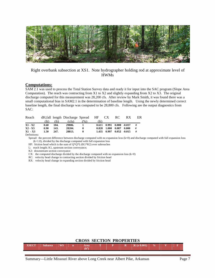
Right
ComputSAM 2.1 wComputatidischarge csmall compbaseline leSAC: Reach X1 - X2 X2 - X3 X1 - X3 Definitions:
Spread: th(k=1.0
HF: frictioL: reach lK2: downCX: the cRC: velocRX: velo
XSECT
y---Little Miss
t overbank su
ations: was used to proon). The reachcomputed for tputational biasngth, the final
dH,fall length (ft) (ft) 0.60 104. 0.90 143. 1.50 247.
he percent differen0), divided by the don head which is thlength; K1, upstrea
nstream section concomputed dischargcity head change icity head change i
Subarea W
souri River ab
ubsection at
ocess the Total h was contractithis measuremes in SAM2.1 indischarge was
h Discharge S (cfs) 29806. 28204. 28813.
nce between dischadischarge computehe sum of Q*Q*Lam section conveynveyance ge divided by the dn contracting sectiin expanding sectio
CRWS n
bove Long Cr
XS1. Note
Station Surveying from X1 toent was 28,200
n the determina computed to b
Spread HF (%) (ft 1 0.61 0 0.82 0 1.43
arge computed wited with full expans
L/(K1*K2) over subyance;
discharge computeion divided by fricon divided by frict
ROSS SECTArea (ft2)
T
reek near Alb
hydrographeHWMs
y data and reado X2 and slight0 cfs. After revation of baselinbe 28,800 cfs.
CX RC t) __________11 0.991 0.00028 1.000 0.08735 0.997 0.052
th no expansion losion loss breaches
d with no expansioction head tion head
TION PROT P
bert Pike, Ark
er holding ro
dy it for input itly expanding fview by Mark Sne length. Usin
Following are
RX ER____________0 -0.037 # 7 0.000 # 2 -0.015 #
ss (k=0) and disch
on loss (k=0)
OPERTIESR K (x 0
kansas
od at approx
into the SAC pfrom X2 to X3Smith, it was fng the newly de the output dia
R
harge computed wi
0.001) %
P
ximate level
program (Slope. The original
found there wadetermined corragnostics from
ith full expansion
V F
Page 7
of
e Area
s a rect
m
loss

Summary---Little Missouri River above Long Creek near Albert Pike, Arkansas Page 8
X1 LOB 113.1 0.039 80.5 21.6 23.3 3.45 7.025 2 6.9 0.63
X1 Main 113.1 0.058 1996.1 157.8 162.7 12.27 272.77 77 10.9 0.54
X1 ROB 113.1 0.08 1237.1 205.4 206.7 5.99 75.964 21 4.9 0.35
X1 Total 113.1 3314 385 393 8.44 355.759 100 8.5 0.51
X2 LOB 114 0.039 161.9 24.4 27.7 5.84 20.061 5 9.1 0.62
X2 Main 114 0.058 2008.1 146.2 151 13.3 289.558 75 10.5 0.5
X2 ROB 114 0.08 1254.5 210.4 211.5 5.93 76.556 20 4.5 0.32
X2 Total 114 3424 381 390 8.78 386.174 100 8.2 0.48
X3 LOB 114.6 0.039 182.4 24.7 28.3 6.44 24.124 6 9.5 0.62
X3 Main 114.6 0.058 2157.6 159.4 163.5 13.2 309.518 79 10.4 0.5
X3 ROB 114.6 0.08 995.2 180.1 180.6 5.51 57.832 15 4.2 0.31
X3 Total 114.6 3335 364 372 8.96 391.473 100 8.5 0.49
Sensitivity analysis was conducted on the n values for the main channel and both overbank subsections. The value of n was allowed to range from 0.042 to 0.070 in the main channel, from 0.032 to 0.060 in the left overbank (LOB) and from 0.060 to 0.100 in the right overbank (ROB).
Original Sensitivity Analysis Results of Holmes FALL N
LOB N Main
N ROB Q Q(1-2) Q(2-3) Q st. dev.
XS2 V LOB XS2 Vmain XS2 ROB
XS2 Froude
1.50 0.039 0.051 0.080 30,800 32,600 29,800 1,419 9.00 11.90 4.40 0.53
1.50 0.039 0.051 0.100 29,200 30,400 28,500 961 8.80 11.70 3.50 0.50
1.50 0.039 0.051 0.060 33,000 35,200 31,800 1,724 9.10 12.00 6.00 0.57
1.50 0.039 0.056 0.080 28,900 30,600 28,000 1,320 9.00 10.90 4.50 0.50
1.50 0.039 0.042 0.080 34,800 36,300 33,900 1,212 8.70 14.00 4.30 0.60
1.50 0.045 0.051 0.080 30,700 32,400 29,700 1,365 7.80 11.90 4.40 0.53
1.50 0.051 0.051 0.080 30,700 32,300 29,700 1,311 6.90 11.90 4.40 0.53
1.50 0.039 0.060 0.080 27,600 29,100 26,700 1,212 9.10 10.20 4.50 0.47
1.50 0.051 0.046 0.080 32,900 34,300 32,000 1,159 6.80 13.10 4.40 0.56
1.50 0.039 0.058 0.080 28,200 29,800 27,300 1,266 9.10 10.50 4.50 0.48
1.50 0.032 0.058 0.080 28,700 30,300 27,700 1,311 11.10 10.60 4.50 0.49
1.50 0.060 0.058 0.080 27,900 29,200 27,148 1,038 5.90 10.60 4.50 0.48
1.50 0.039 0.070 0.080 24,900 26,080 24,188 956 9.20 8.80 4.50 0.43
1.50 0.039 0.058 0.100 26,900 28,100 26,100 1,007 9.00 10.40 3.30 0.46
1.50 0.039 0.058 0.060 30,300 32,100 29,300 1,419 9.10 10.60 6.00 0.52
The sensitivity analysis reveals the following 1. A change in the LOB n value from the minimum (0.032) to the maximum (0.060)
resulted in a decrease of the discharge of 3% 2. A change in the main channel n value from the minimum (0.042) to the maximum
(0.070) resulted in a decrease of the discharge of 40% 3. A change in the ROB n value from the minimum (0.060) to the maximum (0.10) resulted
in a decrease in discharge of 13% Evaluation:

Summary---Little Missouri River above Long Creek near Albert Pike, Arkansas Page 9
Use 28,800 cfs and consider it good to fair reliability. The indirect is graded at good to fair (10 to 15%) based on the following:
1. The high water marks were flagged and surveyed within 4 days of the flood. A good wash line was evident on the left valley wall and a several good high water marks were found in the right overbank. However, there was some variability in the high water marks.
2.The reach was nearly uniform in cross sectional area (neither expanding or contracting), with total Area being 3314, 3424, and 3335 square feet in XS1, XS2, and XS3.
3.The diagnostics (Spread near 0, CX approaching 1, and small values of RX) all look very good.
4. The velocity head change from XS1 to XS3 is less than 5% of the friction head in this reach. The lower this ratio the more accurate the measurement per Kirby (1987).
5.There is little evidence that the reach cross section main channel has changed much during the flood. The channel is remarkably stable.
6.There is no evidence that this flood was a debris flow based on evidence left behind such as scouring and deposition.
7.During the field recon, it was thought that the constriction 427 ft downstream of XS3 might induce critical flow depth. As such a surveyed cross section and high water marks were collected at the constriction. Using HWMs at the constriction, the mean hydraulic depth (D=A/T) computes as 9.63 ft with a cross sectional area of 2,196 ft2. From critical flow
equation ( gDV ), the flow (assuming the computed depth was critical depth) was
38,600 cfs, which way overestimated the flow given from SAC. In addition, a new four section SAC run that included XS4 estimated the Froude number at the constriction to be 0.67, much less than the critical flow state. The critical flow computation was not helpful in determining the actual flow, but puts an definitive upper bound on the possible peak flow at this location.
Previous computations: None Remarks: After review by Mark Smith, peak streamflow was changed from 28,200 cfs to 28,800 cfs. Also measurement quality was slightly downgraded from good to good-fair based on recommendation from Smith. Computed By: Robert R. Holmes, Jr. PhD, P.E., D.WRE National Flood Specialist Date: July 29, 2010

Summary---Little Missouri River above Long Creek near Albert Pike, Arkansas Page 10
Checked By: Daniel M. Wagner Arkansas Water Science Center Date:October 6, 2010 Reviewed By: Mark Smith Regional Surface Water Specialist Date: December 10, 2010 Approval: Mark E. Smith Surface Water Specialist, Central Water Science Field Team Date: January 21, 2011
Summary---Little Missouri River above Long Creek near Albert Pike, Arkansas Page 11
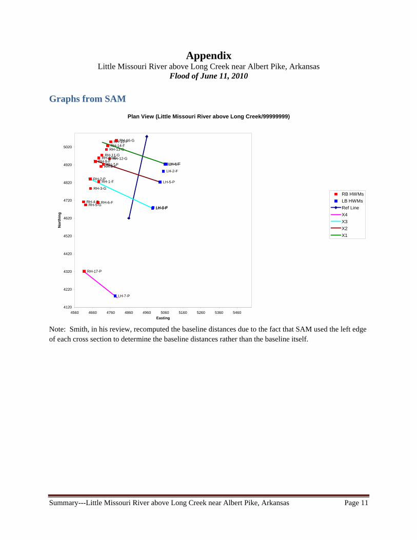
Appendix Little Missouri River above Long Creek near Albert Pike, Arkansas
Flood of June 11, 2010 Graphs from SAM
Note: Smith, in his review, recomputed the baseline distances due to the fact that SAM used the left edge of each cross section to determine the baseline distances rather than the baseline itself.
Plan View (Little Missouri River above Long Creek/99999999)
RH-9-FRH-8-FRH-7-F
RH-6-FRH-5-G
RH-4-F
RH-3-G
RH-2-PRH-1-F
RH-17-P
RH-16-GRH-15-FRH-14-F
RH-13-G
RH-12-GRH-11-G
RH-10-G
LH-7-P
LH-6-P
LH-5-P
LH-4-F
LH-3-P
LH-2-F
LH-1-F
4120
4220
4320
4420
4520
4620
4720
4820
4920
5020
4560 4660 4760 4860 4960 5060 5160 5260 5360 5460
Easting
No
rth
ing
RB HWMs
LB HWMs
Ref Line
X4
X3
X2
X1
Summary---Little Missouri River above Long Creek near Albert Pike, Arkansas Page 12
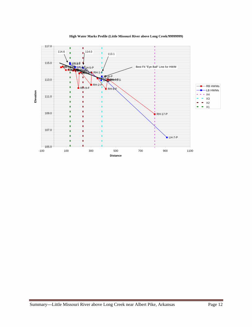
High Water Marks Profile (Little Missouri River above Long Creek/99999999)
RH-16-GRH-15-FRH-14-FRH-13-GRH-11-GRH-12-GRH-10-G
RH-9-F
RH-7-FRH-8-F
RH-2-P
RH-1-F
RH-3-G
RH-6-F
RH-4-FRH-5-G
RH-17-P
LH-1-FLH-4-FLH-2-FLH-5-P
LH-3-PLH-6-P
LH-7-P
105.0
107.0
109.0
111.0
113.0
115.0
117.0
-100 100 300 500 700 900 1100
Distance
Ele
vati
on
RB HWMs
LB HWMs
X4
X3
X2
X1
Best Fit "Eye Ball" Line for HWM
114.6113.1
114.0

Summary---Little Missouri River above Long Creek near Albert Pike, Arkansas Page 13
Cross Section X3
X3-40
X3-39
X3-38X3-37X3-36X3-35X3-33
X3-32X3-31
X3-29X3-30
X3-28X3-27X3-26
X3-25X3-24X3-23
X3-22
X3-21X3-20
X3-19
X3-18X3-17X3-16
X3-15X3-14X3-13
X3-12X3-11X3-10
X3-9
X3-8
X3-7
X3-6
X3-5X3-4
X3-1
90.0
95.0
100.0
105.0
110.0
115.0
120.0
0.0 50.0 100.0 150.0 200.0 250.0 300.0 350.0 400.0 450.0
Station
Ele
vati
on
n=0.058n=0.080
n=0.039
Cross Section X2
X2-35
X2-34X2-22X2-30
X2-29
X2-28X2-27
X2-26
X2-25X2-24
X2-23
X2-22
X2-21X2-20
X2-19
X2-18
X2-17-REW
X2-16X2-15X2-14X2-13
X2-12X2-11
X2-10-LEW
X2-9
X2-8X2-7
X2-6
X2-5X2-4X2-3
X2-1
90.0
95.0
100.0
105.0
110.0
115.0
120.0
0.0 50.0 100.0 150.0 200.0 250.0 300.0 350.0 400.0 450.0
Station
Ele
vati
on
n=0.058
n=0.039
n=0.080

Summary
RoughnMain CMain chacompositrock and width). The left sThe rightThe low Chow (19The Bed be represequations
DDDS RT
Followin
Meyer-P
90.0
95.0
100.0
105.0
110.0
115.0
120.0
0
Ele
vati
on
y---Little Miss
ness Estimhannel annel was este n value. Tgravel bed l
shore was est shore was ewater chann959), enginematerial siz
sentative of ts are as follo
D90= 0.15 meteD84=0.38 ft D50 = 0.15 ft; 0
(friction slopeR = 16 ft; 4.9 m
=148 ft, ng are compu
eter Muller(
X
X1-4X1-3
X1-2
X1-1
.0 50.0
n=0.039
souri River ab
mates
stimated by dThe main chalow water ch
stimated to bestimated to nel was estimeering judgete data came the size of grows: ers
0.048 m e)=0.0043
meters
utations:
1948) equat
XXX
X1-
X1-7X1-6
X1-5
0 100.0
n=0.058
bove Long Cr
doing a weigannel had brhannel (47 ft
be n= 0.090.be n = 0.080
mated to be 0tment, and sfrom the gra
ravel presen
ion for grave
Cro
X
X1-17
X1-16-
X1-15X1-14X1-13X1-12X1-11X1-10-LEWX1-9
-8
150.0
8
reek near Alb
ghted (by wirush and treet in width) an
0. 0.031. This weveral theoravel bar 170
nt at the indir
el bed stream
oss Section X1
X1X1-22
X1-21X1-20
X1-19
X1-18
-REW
200.0
Station
bert Pike, Ark
dth) estimates on the leftnd a treed/br
was based oretical equati00 feet belowrect location
ms
X1-
X1-24X1-251-232
250.0
n=0.080
kansas
te of the maint shore (70 ftrush right sh
n published ions based ow the reach bn. The data f
(metric uni
X1-28X1-27
-26
300.0
0
Pa
n channel ft in width), ahore (42 ft in
n values in on bed materbut was judgfor the theore
its) ---n = 0.0
X1-
X1-31
X1-30X1-29
350.0 4
age 14
a n
ial. ged to etical
028,
32
400.0

Summary
Jarretts (
Limerino
Froelich’units)----
Griffiths A weighte
Wi70474215
cn
For this in
judgmentBarnes (1sensitivit
y---Little Miss
1984) equati
os (1970) for
’s (1978) equ-- n = 0.024;
(1981) equa
ed value of n idth(W) n’ 0.4 0’ 09.9
15913.11c
ndirect, a n va
t, weighting 1967, http://pty analysis d
souri River ab
ion for moun
r gravel strea
uation for gr
ation for grav
for the main n W*n0.090 6.3 0.031 1.460.080 3.36
11.1
0698.09.
alue of 0.058
of n values pubs.usgs.go
data.
bove Long Cr
ntain stream
ams in Califo
ravel and cob
vel rivers
channel is 0.0n
69 6 13
was used for
from channeov/wsp/wsp_
reek near Alb
ms
fornia
bble streams
(
056.
the main cha
el width (abo_1849/pdf/w
bert Pike, Ark
(Engl
(E
s
(all SI units)
annel. This w
ove), examiwsp_1849.pd
kansas
ish units) ---
English units
) ---- n = 0.0
was based on eination of ph
df), and revie
Pa
- n = 0.038;
s) ---n =0.03
(English
31.
engineering hotos from ew of the
age 15
33;

Summary---Little Missouri River above Long Creek near Albert Pike, Arkansas Page 16
SAC INPUT DATA T1 SAC/WSPRO Input for Little Missouri River above Long Creek (99999999) T2 Shortened reach 3-2 by 10 feet (to 143 ft) - MES Q WS 112.9 XS X3 378 GR 0,115.1 7.7,108.6 24,109.2 35.2,107.4 42.4,103.1 50.5,98.4 51.4,97.2 GR 54.1,96.2 63.8,97.2 73.6,97.2 76.3,96.3 85.4,96 99.5,96.5 104.9,97.2 GR 112.3,97.4 116.3,98.2 122.7,99.9 140.1,100.8 155.7,101.6 165.5,103.6 GR 176.8,107.7 181.8,107.9 187.9,107.7 196.3,108.4 217.8,108.3 GR 235.3,107.4 251.1,105.9 257.3,105.8 276.5,105 303.3,105.6 GR 331.5,107.7 339.3,107.5 346.7,106.6 355.8,106.9 369.4,107.2 GR 380.8,110.7 394.4,115.8 N .039 .058 0.08 SA 24.0 181.8 HP 4 X3 113.1 XS X2 235 GR 0,117.9 12.1,105.9 28.3,106.2 39.9,105.3 49.9,101 62.6,99.7 70.4,100 GR 75.2,98.8 76.5,97.3 77.7,95.6 84.4,94.6 88.5,95.3 99.4,95.4 GR 114.3,95.2 116.5,95.9 124,97.4 126.2,98.9 133.2,100.5 146.7,101.9 GR 154.4,102.9 165.7,107.3 174.5,108.6 183.9,107.9 193.5,108.6 GR 218.6,107.2 236.1,105.5 254.6,105.7 289.4,107.6 319.1,109.5 GR 342.4,109.1 369.9,108.9 388.1,115.1 N .039 .058 .08 SA 28.3 174.5 HP 4 X2 114.0 XS X1 131 GR 0,117.4 7.4,111.4 14.9,104.9 28.2,105.1 49.2,103.1 71.4,100.5 GR 81.3,101.2 98.3,99.8 102.9,98.4 103.7,97.4 104.3,96.3 112.5,95.9 GR 120.8,96.2 132.1,96.3 140.9,96.1 143.6,97.3 145.6,100 159.2,102.9 GR 176.3,106.9 187.6,107.8 194.6,106.9 202.1,107.4 214.2,106.5 GR 240,106.1 247,106.4 266.2,107.8 291,109.6 307.9,110.6 336,111.5 GR 350,112.5 362.3,113.7 377.4,116.2 N 0.039 0.058 0.08 SA 28.2 187.6 HP 4 X1 114.6

Summary---Little Missouri River above Long Creek near Albert Pike, Arkansas Page 17
SAC OUTPUT DISCHARGE COMPUTATIONS Reach dH,fall length Discharge Spread HF CX RC RX ER (ft) (ft) (cfs) (%) (ft) X1 - X2 0.60 104. 29806. 1 0.611 0.991 0.000 -0.037 # X2 - X3 0.90 143. 28204. 0 0.828 1.000 0.087 0.000 # X1 - X3 1.50 247. 28813. 0 1.435 0.997 0.052 -0.015 # Definitions: Spread, the percent difference between discharge computed with no expansion loss (k=0) and discharge computed with full expansion loss (k=1.0), divided by the discharge computed with full expansion loss HF, friction head- HF = sum of Q*Q*L/(K1*K2) over subreaches; Q, discharge; L, reach length; K1, upstream section conveyance; K2, downstream section conveyance CX, the computed discharge divided by the discharge computed with no expansion loss (k=0) RC, velocity head change in contracting section divided by friction head RX, velocity head change in expanding section divided by friction head ER, warnings, *-fall <' 0.5ft, @-conveyance ratio exceeded, #-reach too short error, 1-negative or 0 fall ******, terms that can not be computed because' of strong expansion in reach

Summary
Append
y---Little Miss
dix1—Anc
souri River ab
cillary Com
bove Long Cr
mputation
reek near Alb
n of Q at C
bert Pike, Ark
Constrictio
kansas
on Downs
Pa
tream
age 18