Embed Size (px)
Citation preview

INDIVIDUAL PROJECT ORDER NUMBER 2 January 5, 2010
Describing a specific agreement between Kimley-Horn and Associates, Inc. (“KHA” or the “Consultant”), and The Village Center Community Development District (the “District”) in accordance with the terms of the Professional Services Agreement for The VCCDD Multi-Modal Path System North of CR 466 project (RFQ#09Q-029) dated May 14, 2009, which is incorporated herein by reference.
Identification of Project: Villages Transportation Trails (North of CR 466) – Construction Plans and Permitting
Project Understanding: 1. The VCCDD has been charged with reconstructing the main segments of the existing multi-modal
path system north of CR 466 in The Villages. The District would like the Consultant to provide preliminary design, final design, construction plans, and permitting services associated with the following specific modifications to the transportation trails (each area will be prepared as a separate set of construction plans):
A. Reconstruct the trail on Buena Vista Boulevard (VCCDD District 4). ♦ Replace existing concrete trail with 15.5’ asphalt trail bounded by 6” concrete ribbon curbs.
B. Reconstruct the trail on Buena Vista Boulevard (VCCDD District 3). ♦ Replace existing concrete trail with 15.5’ asphalt trail bounded by 6” concrete ribbon curbs.
C. Reconstruct the trail on El Camino Real (Buena Vista Boulevard to Morse Boulevard). ♦ Replace existing concrete trail with 15.5’ asphalt trail bounded by 6” concrete ribbon curbs. ♦ Relocate the trail crossing at Santo Domingo behind the gate.
D. Extend the off-street Morse Boulevard trail to the roundabout at El Camino Real. ♦ Replace existing district-maintained concrete trail with asphalt trail bounded by 6” concrete
ribbon curbs (width TBD). ♦ Construct a new transportation trail on the west side of Morse Boulevard from the existing
trail that ends near the Village of Homewood to the El Camino trail.
E. Reconstruct the Saddlebrook trail from the Buena Vista Boulevard tunnel to the CR 466 tunnel. ♦ Replace existing concrete trail with asphalt trail bounded by 6” concrete ribbon curbs (width
TBD).
F. Reconstruct the trail in the area of Paradise Park near the US 441 trail bridge. ♦ Construct a new trail outside of the existing parking lot area, and reconfigure parking lot area. ♦ Eliminate the current cart access location at the southern edge of the parking area and
demolish portions of the existing path. ♦ Construct new 15.5’ asphalt trail bounded by 6” ribbon curbs to connect the new trail at the
parking area to the eastern edge of the US 441 cart overpass. Construct divided 10’ trails to avoid tree impact at the existing trail section on eastern side of US441/27. Construct new asphalt trail on west side between the bridge and parking lot.
2. The design for this project will be prepared in accordance with the guidelines and standards established in the Programming Plan prepared by the Consultant in December 2009.

IPO #2 – The VCCDD Trails, January 5, 2010, Page 2
3. Permits will be required from the Southwest Florida Water Management District (SWFWMD) and the St. John’s River Water Management District (SJRWMD). In addition, input from Sumter County, Marion County and the Town of Lady Lake will need to be incorporated into the design. The exact permitting requirements are unknown at this time.
4. Since the project is within The Villages, the Consultant will coordinate and discuss modifications within the corridor with The Villages of Lake-Sumter, Inc.
5. KHA will coordinate with three sub-consultants on this Project: Farner Barley and Associates, Inc., Michael Pape and Associates, Inc., and Andreyev Engineering.
With the above in mind, our specific scope of services, schedule and fee are provided below.
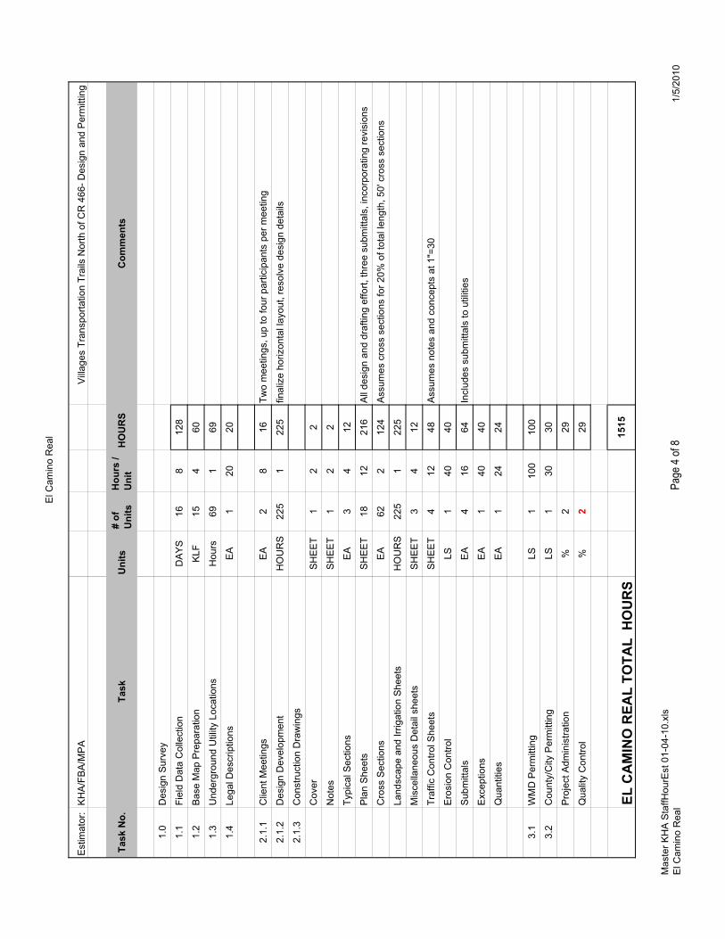
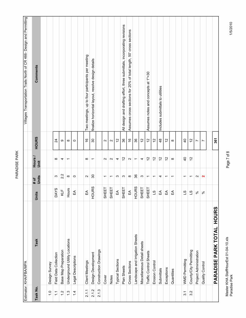
Specific Scope of Services: Task 1.0 – Design Survey (Provided by Farner Barley and Associates, Inc.) 1.1 Field Data Collection:
The Consultant will perform field surveys to acquire relevant and pertinent data such as ground shots, locations of landscaping (such as trees, shrub outlines, mulch beds), horizontal location of utilities, visible irrigation components, above ground utilities, fences, walls, and other locations deemed necessary by KHA. The horizontal limits of the field survey data will generally be from edge of roadway to either the right of way, CDD easement / lot line, or limiting physical feature such as a wall, tunnel, dense landscape buffer, etc.
The field surveys will generally conform with the phasing limits of the construction plans.
1.2 Underground Utility Locations: The Consultant will field locate existing utilities using typical accepted methods of location, including the services of locator companies (Sunshine One, etc.), ground penetrating radar, direct connection to utility tracer wires, existing record drawing maps maintained by the Villages, CH2MHill, the VCCDD, SECO, etc.
The magnitude of underground utility locations is expected to be great. The Consultant will endeavor to locate underground utilities to the best of our ability, but some amount of field discovery during construction should be expected.
1.3 Base Map Preparation: Using the data collected in Tasks 1.1 and 1.2, the Consultant will create an AutoCAD base survey file suitable for preparation of design plans. The base file will include right-of-way lines, existing structures and improvements, elevations, and landscaping. The Consultant will provide horizontal and vertical control consisting of permanent and temporary benchmarks and off-sets of horizontal control points.
1.4 Legal Descriptions: Prepare up to ten (10) miscellaneous legal descriptions for property transfers as may be needed.
Task 2.0 – Transportation Trail Construction Plans The Consultant will prepare for and attend general progress meetings as well as provide coordination with the District. This proposal assumes up to four (4) general progress meetings over the course of the project. Provide meeting minutes within one week after the progress meetings.

IPO #2 – The VCCDD Trails, January 5, 2010, Page 3
Transportation Trail Plans and Design Analysis
2.1.1 The Consultant will meet with District staff up to two times during the design of each set of construction drawings to discuss issues specific to each segment of the Project.
2.1.2 Using the design survey as a base, the design team will review factors affecting the proposed realignment of the multi-modal trail, considering all team disciplines. All factors such as existing trees, existing irrigation mainline, screening of homesites, grade issues, vertical and horizontal alignment, drainage issues, etc. will be considered to determine the expected alignment and exact location of the multi-modal trail.
The Consultant’s design team will prepare preliminary alignments for the proposed improvements and make field visits to observe expected impacts to landscaping and irrigation systems, constraints due to walls, tunnels, or other permanent improvements, and to generally confirm and refine the preliminary alignments.
2.1.3 The Consultant will prepare construction drawings suitable for permitting, bidding and construction. One set of construction plans will be prepared for each of the six sub-phases identified in the Project Understanding. Each set of construction plans will generally include the following sheets:
♦ Cover Sheet ♦ General Notes ♦ Typical Sections (Up to 3 Typical Sections) – Typical sections will be developed to
illustrate the recommended roadway improvements from the corridor study. ♦ Plan Sheets (Triple Panel at 1”=10’) – The plan sheets will detail geometric design
requirements, trail removal, trail replacement, ditch grading and re-alignment in areas of pavement widening, drainage structure modifications, striping/signage, and erosion control measures.
♦ Cross Sections (Up to 20% of the total length) – Vertical cross sections will be developed at 50-foot intervals in areas where pavement widening is proposed that requires specific additional detail to properly design the proposed improvements.
♦ Landscaping and Irrigation Plans (Triple Panel at 1”=10’) – The landscaping and irrigation plans will detail trees and vegetation to be removed within the affected areas, and irrigation design for new or modified landscape areas. The landscaping and irrigation plans will also specify trees and vegetation to remain and be protected, and provide typical installation details for the types of landscaping expected to be installed as part of this Project.
♦ Miscellaneous Construction Detail sheets ♦ Traffic Control Sheets Maintenance of Traffic requirements for the construction of this
project will be provided through the use of typical sections, general notes, reference to the appropriate FDOT Design Standards (600 Series), and where needed, conceptual illustrations.
♦ Erosion Control General Notes – Erosion control requirements will be provided in the form of general notes. Project specific erosion control measures will be shown on the Plan Sheets.
♦ Submittals – The Consultant will submit up to five (5) copies of the roadway plans at 60%, 90%, and Final completion stage to the District. In addition, the Consultant will submit two (2) copies of the roadway plans at 60% and Final completion stage to affected utility companies. The plan sheets will be submitted as 11”x17” plan sheets in the interim stages

IPO #2 – The VCCDD Trails, January 5, 2010, Page 4
and as 22”x34” plan sheets in the final signed and sealed submittal. An electronic copy will be provided at the Final plan submittal as well.
♦ Design Exceptions – The Consultant will review survey data and identify any areas in which minimum shoulder width or maximum front slope criteria cannot be met due to existing R/W or wetland conditions. The Consultant will also review existing above ground hazards (trees, power poles, walls, etc) within the clear zone and identify those existing features which must be removed or shielded. In areas where the removal of the hazard is not practical and the use of shielding is inappropriate the will prepare documentation for one (1) design exception which could support leaving the hazard in place if operational and safety characteristics are acceptable.
♦ Quantities – Develop quantities consistent with District preferences and prepare an Opinion of Probable Costs (OPC). The OPC will be submitted with the final plan submittal.
Note: The Consultant has no control over the cost of labor, materials, equipment, or over the Contractor’s methods of determining prices or over competitive bidding or market conditions. Opinions of probable costs provided in accordance with this Agreement are based on the information known to Consultant at the time the opinions of cost are developed and represent only the Consultant’s judgment as a design professional familiar with the construction industry. Actual costs for proposals, bids, or actual construction costs will be different.
Task 3.0 – Permitting 3.1 SWFWMD and SJRWMD Permitting:
The Consultant will schedule and attend a meeting with each water management district to discuss the Project. This meeting will provide the review staff with an understanding of the proposed improvements, and to help them determine the level of permitting required. It is anticipated that each water management district will require an Environmental Resource Permit (ERP) for each set of construction drawings.
The Consultant will prepare and submit a permit application package with supporting plans and data with the 60% plan submittal for each set of plans prepared. This proposal assumes that the project will not require new pond/water retention facilities. The Consultant will respond to requests for additional information as appropriate.
3.2 City and County Permitting: In addition to water management district permitting, each project will be submitted to the local government (either the Town of Lady Lake, Sumter County, or Marion County, based on the project). The Consultant will meet with County or City development review staff to discuss the project and determine the level of permitting that will be required. It is anticipated that the local governments will require review of the stormwater management calculations, but not require a full review of construction plan documents
The Consultant will prepare an application package to the agencies utilizing the 60% plans for each set of construction drawings. The Consultant will respond to reasonable requests for additional information.
Additional Services if required: Services requested that are not specifically included will be provided under a new and separate IPO agreement. These services may include:
♦ Additional Projects incorporating transportation trail modifications. ♦ Bidding and Construction Administration.

IPO #2 – The VCCDD Trails, January 5, 2010, Page 5
♦ Additional graphics. ♦ Public meetings. ♦ Design of new stormwater ponds or modifications to existing ponds. ♦ Utility Adjustment Plans.
Schedule The Consultant will provide our services as expeditiously as practicable to meet the project objectives. The Consultant will develop a schedule at project kick-off and maintain the schedule jointly with VCCDD staff.
Method of compensation: Services under this IPO will be provided in accordance with Item #10 of the Professional Services Agreement on a time and materials basis in accordance with the approved rate schedule (Exhibit “A” of the Professional Services Agreement). Payment of each invoice will be made by the District on a monthly basis and pursuant to the provisions of the Local Government Prompt Payment Act, F.S. 218.
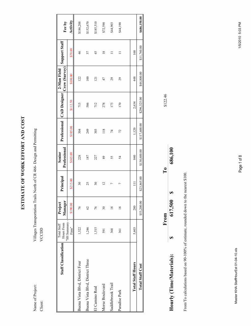
The anticipated budget to complete the IPO is between $617,500 and $686,100, exclusive of direct expenses. A breakdown by project is as follows:
Project Labor Fee Ranges Buena Vista Boulevard, District Four $160,900 - $186,300Buena Vista Boulevard, District Three $140,400 - $152,700El Camino Real $172,000 - $185,500Morse Boulevard $64,000 - $72,600Saddlebrook Trail $40,400 - $44,900Paradise Park $39,800 - $44,100Total: $617,500 - $686,100
The fee ranges above shall be considered “not to exceed” values. If additional hours are needed to complete the required task(s), written approval from VCCDD must be obtained before proceeding.
A work estimate of staff hours is included in Exhibit “B”.
ACCEPTED:
THE VILLAGE CENTER COMMUNITY KIMLEY-HORN AND ASSOCIATES, INC. DEVELOPMENT DISTRICT BY: BY: Jonathan D. Thigpen, PE TITLE: TITLE: Vice President DATE: DATE: January 5, 2010
G:\Marketing\Public Sector\VCCDD\2010\JDT\VCCDD IPO2 010510.doc
EST
IMA
TE
OF
WO
RK
EFF
OR
T A
ND
CO
ST
Nam
e of
Pro
ject
: V
illag
es T
rans
porta
tion
Trai
ls N
orth
of C
R 4
66- D
esig
n an
d Pe
rmitt
ing
Clie
nt:
VC
CD
D
Fee
by$1
90.0
0$2
15.0
0$1
65.0
0$1
05.0
0$1
12.5
0$1
00.0
0$7
0.00
Act
ivity
Bue
na V
ista
Blv
d, D
istri
ct F
our
1,52
276
3022
830
471
512
246
$186
,288
Bue
na V
ista
Blv
d, D
istri
ct T
hree
1,24
662
2518
724
958
610
037
$152
,670
El C
amin
o R
eal
1,51
576
3022
730
371
212
145
$185
,510
Mor
se B
oule
vard
591
3012
8911
827
847
18$7
2,59
0
Sadd
lebr
ook
Trai
l36
818
755
7417
329
11$4
4,90
3
Para
dise
Par
k36
118
754
7217
029
11$4
4,19
0
Tot
al S
taff
Hou
rs5,
603
280
111
840
1,12
02,
634
448
168
Tot
al S
taff
Cos
t$5
3,20
0.00
$23,
865.
00$1
38,6
00.0
0$1
17,6
00.0
0$2
96,3
25.0
0$4
4,80
0.00
$11,
760.
00$6
86,1
50.0
0
From
To
$122
.46
Hou
rly
(Tim
e/M
ater
ials
):61
7,50
0$
68
6,10
0$
From
/To
calc
ulat
ions
bas
ed o
n 90
-100
% o
f est
imat
e, ro
unde
d do
wn
to th
e ne
ares
t $10
0.
Staf
f Cla
ssifi
catio
n2-
Man
Fie
ld
Cre
w (S
urve
y)Su
ppor
t Sta
ffPr
ojec
t M
anag
erPr
inci
pal
Seni
or
Prof
essi
onal
Prof
essi
onal
CA
D D
esig
ner
Tota
l Sta
ff
Hou
rs F
rom
"S
H S
umm
ary
- Fi
rm"
Mas
ter K
HA
Sta
ffHou
rEst
01-
04-1
0.xl
s 1
of 1
1/5/
2010
5:0
3 P
MPa
ge 1
of 8

Bue
na V
ista
Dis
trict
Fou
r
Est
imat
or:
KH
A/F
BA
/MP
AV
illag
es T
rans
porta
tion
Trai
ls N
orth
of C
R 4
66- D
esig
n an
d P
erm
ittin
g
Task
No.
Task
Uni
ts#
of
Uni
tsH
ours
/ U
nit
HO
UR
SC
omm
ents
1.0
Des
ign
Sur
vey
1.1
Fiel
d D
ata
Col
lect
ion
DA
YS
158
120
1.2
Bas
e M
ap P
repa
ratio
nK
LF14
.048
456
1.3
Und
ergr
ound
Util
ity L
ocat
ions
Hou
rs62
162
1.4
Lega
l Des
crip
tions
EA
0
2.1.
1C
lient
Mee
tings
EA
28
16Tw
o m
eetin
gs, u
p to
four
par
ticip
ants
per
mee
ting
2.1.
2D
esig
n D
evel
opm
ent
HO
UR
S20
01
200
final
ize
horiz
onta
l lay
out,
reso
lve
desi
gn d
etai
ls/is
sues
2.1.
3C
onst
ruct
ion
Dra
win
gs
Cov
erS
HE
ET
12
2
Not
esS
HE
ET
12
2
Typi
cal S
ectio
nsE
A3
412
Pla
n S
heet
sS
HE
ET
1712
204
All
desi
gn a
nd d
rafti
ng e
ffort,
thre
e su
bmitt
als,
inco
rpor
atin
g re
visi
ons
Cro
ss S
ectio
nsE
A56
211
2A
ssum
es c
ross
sec
tions
for 2
0% o
f tot
al le
ngth
, 50'
cro
ss s
ectio
ns
Land
scap
e an
d Irr
igat
ion
She
ets
HO
UR
S19
61
196
on s
ame
shee
t
Mis
cella
neou
s D
etai
l she
ets
SH
EE
T3
412
Traf
fic C
ontro
l She
ets
SH
EE
T6
1272
Ass
umes
not
es a
nd c
once
pts
at 1
"=30
Ero
sion
Con
trol
LS1
4040
Sub
mitt
als
EA
416
64In
clud
es s
ubm
ittal
s to
util
ities
Exc
eptio
nsE
A1
4040
Qua
ntiti
esE
A1
2424
3.1
WM
D P
erm
ittin
gLS
120
020
0In
clud
es g
eote
chni
cal r
ecov
ery
anal
ysis
3.2
Cou
nty/
City
Per
mitt
ing
LS1
3030
Pro
ject
Adm
inis
tratio
n%
229
Qua
lity
Con
trol
%2
29
B
UEN
A V
ISTA
DIS
TRIC
T FO
UR
TO
TAL
HO
UR
S15
22
Mas
ter K
HA
Sta
ffHou
rEst
01-
04-1
0.xl
sB
uena
Vis
ta D
istri
ct F
our
Pag
e 1
of 1
1/5/
2010
Page
2 of
8

Bue
na V
ista
Dis
trict
Thr
ee
Est
imat
or:
KH
A/F
BA
/MP
AV
illag
es T
rans
porta
tion
Trai
ls N
orth
of C
R 4
66- D
esig
n an
d P
erm
ittin
g
Task
No.
Task
Uni
ts#
of U
nits
Hou
rs /
Uni
tH
OU
RS
Com
men
ts
1.0
Des
ign
Sur
vey
1.1
Fiel
d D
ata
Col
lect
ion
DA
YS
138
104
1.2
Bas
e M
ap P
repa
ratio
nK
LF11
.351
445
1.3
Und
ergr
ound
Util
ity L
ocat
ions
Hou
rs54
154
1.4
Lega
l Des
crip
tions
EA
0
2.1.
1C
lient
Mee
tings
EA
28
16Tw
o m
eetin
gs, u
p to
four
par
ticip
ants
per
mee
ting
2.1.
2D
esig
n D
evel
opm
ent
HO
UR
S16
51
165
final
ize
horiz
onta
l lay
out,
reso
lve
desi
gn d
etai
ls
2.1.
3C
onst
ruct
ion
Dra
win
gs
Cov
erS
HE
ET
12
2
Not
esS
HE
ET
12
2
Typi
cal S
ectio
nsE
A3
412
Pla
n S
heet
sS
HE
ET
1412
168
All
desi
gn a
nd d
rafti
ng e
ffort,
thre
e su
bmitt
als,
inco
rpor
atin
g re
visi
ons
Cro
ss S
ectio
nsE
A45
290
Ass
umes
cro
ss s
ectio
ns fo
r 20%
of t
otal
leng
th, 5
0' c
ross
sec
tions
Land
scap
e an
d Irr
igat
ion
She
ets
HO
UR
S19
01
190
Mis
cella
neou
s D
etai
l she
ets
SH
EE
T3
412
Traf
fic C
ontro
l She
ets
SH
EE
T4
1248
Ass
umes
not
es a
nd c
once
pts
at 1
"=30
Ero
sion
Con
trol
LS1
3232
Sub
mitt
als
EA
416
64In
clud
es s
ubm
ittal
s to
util
ities
Exc
eptio
nsE
A1
4040
Qua
ntiti
esE
A1
2424
3.1
WM
D P
erm
ittin
gLS
110
010
0
3.2
Cou
nty/
City
Per
mitt
ing
LS1
3030
Pro
ject
Adm
inis
tratio
n%
224
Qua
lity
Con
trol
%2
24
BU
ENA
VIS
TA D
ISTR
ICT
THR
EE T
OTA
L H
OU
RS
1246
Mas
ter K
HA
Sta
ffHou
rEst
01-
04-1
0.xl
sB
uena
Vis
ta D
istri
ct T
hree
Pag
e 1
of 1
1/5/
2010
Page
3 of
8
El C
amin
o R
eal
Est
imat
or:
KH
A/F
BA
/MP
AV
illag
es T
rans
porta
tion
Trai
ls N
orth
of C
R 4
66- D
esig
n an
d P
erm
ittin
g
Task
No.
Task
Uni
ts#
of
Uni
tsH
ours
/ U
nit
HO
UR
SC
omm
ents
1.0
Des
ign
Sur
vey
1.1
Fiel
d D
ata
Col
lect
ion
DA
YS
168
128
1.2
Bas
e M
ap P
repa
ratio
nK
LF15
460
1.3
Und
ergr
ound
Util
ity L
ocat
ions
Hou
rs69
169
1.4
Lega
l Des
crip
tions
EA
120
20
2.1.
1C
lient
Mee
tings
EA
28
16Tw
o m
eetin
gs, u
p to
four
par
ticip
ants
per
mee
ting
2.1.
2D
esig
n D
evel
opm
ent
HO
UR
S22
51
225
final
ize
horiz
onta
l lay
out,
reso
lve
desi
gn d
etai
ls
2.1.
3C
onst
ruct
ion
Dra
win
gs
Cov
erS
HE
ET
12
2
Not
esS
HE
ET
12
2
Typi
cal S
ectio
nsE
A3
412
Pla
n S
heet
sS
HE
ET
1812
216
All
desi
gn a
nd d
rafti
ng e
ffort,
thre
e su
bmitt
als,
inco
rpor
atin
g re
visi
ons
Cro
ss S
ectio
nsE
A62
212
4A
ssum
es c
ross
sec
tions
for 2
0% o
f tot
al le
ngth
, 50'
cro
ss s
ectio
ns
Land
scap
e an
d Irr
igat
ion
She
ets
HO
UR
S22
51
225
Mis
cella
neou
s D
etai
l she
ets
SH
EE
T3
412
Traf
fic C
ontro
l She
ets
SH
EE
T4
1248
Ass
umes
not
es a
nd c
once
pts
at 1
"=30
Ero
sion
Con
trol
LS1
4040
Sub
mitt
als
EA
416
64In
clud
es s
ubm
ittal
s to
util
ities
Exc
eptio
nsE
A1
4040
Qua
ntiti
esE
A1
2424
3.1
WM
D P
erm
ittin
gLS
110
010
0
3.2
Cou
nty/
City
Per
mitt
ing
LS1
3030
Pro
ject
Adm
inis
tratio
n%
229
Qua
lity
Con
trol
%2
29
EL C
AM
INO
REA
L TO
TAL
HO
UR
S15
15
Mas
ter K
HA
Sta
ffHou
rEst
01-
04-1
0.xl
sE
l Cam
ino
Rea
lP
age
1 of
11/
5/20
10Pa
ge 4
of 8

Mor
se B
lvd
Est
imat
or:K
HA
/FB
A/M
PA
Vill
ages
Tra
nspo
rtatio
n Tr
ails
Nor
th o
f CR
466
- Des
ign
and
Per
mitt
ing
Task
No.
Task
Uni
ts#
of
Uni
tsH
ours
/ U
nit
HO
UR
SC
omm
ents
1.0
Des
ign
Sur
vey
1.1
Fiel
d D
ata
Col
lect
ion
DA
YS
68
48
1.2
Bas
e M
ap P
repa
ratio
nK
LF5.
54
22
1.3
Und
ergr
ound
Util
ity L
ocat
ions
Hou
rs24
124
1.4
Lega
l Des
crip
tions
EA
124
24
2.1.
1C
lient
Mee
tings
EA
28
16Tw
o m
eetin
gs, u
p to
four
par
ticip
ants
per
mee
ting
2.1.
2D
esig
n D
evel
opm
ent
HO
UR
S36
136
final
ize
horiz
onta
l lay
out,
reso
lve
desi
gn d
etai
ls
2.1.
3C
onst
ruct
ion
Dra
win
gs
Cov
erS
HE
ET
12
2
Not
esS
HE
ET
12
2
Typi
cal S
ectio
nsE
A3
412
Pla
n S
heet
sS
HE
ET
712
84A
ll de
sign
and
dra
fting
effo
rt, th
ree
subm
ittal
s, in
corp
orat
ing
revi
sion
s
Cro
ss S
ectio
nsE
A40
280
Ass
umes
cro
ss s
ectio
ns fo
r new
trai
l len
gth
at 5
0' c
ross
sec
tions
Land
scap
e an
d Irr
igat
ion
She
ets
HO
UR
S45
145
Mis
cella
neou
s D
etai
l she
ets
SH
EE
T3
412
Traf
fic C
ontro
l She
ets
SH
EE
T1
1212
Ass
umes
not
es a
nd c
once
pts
at 1
"=30
Ero
sion
Con
trol
LS1
1212
Sub
mitt
als
EA
412
48In
clud
es s
ubm
ittal
s to
util
ities
Exc
eptio
nsE
A0
0
Qua
ntiti
esE
A1
88
3.1
WM
D P
erm
ittin
gLS
170
70
3.2
Cou
nty/
City
Per
mitt
ing
LS1
1212
Pro
ject
Adm
inis
tratio
n%
211
Qua
lity
Con
trol
%2
11
M
OR
SE B
OU
LEVA
RD
TO
TAL
HO
UR
S59
1
Mas
ter K
HA
Sta
ffHou
rEst
01-
04-1
0.xl
sM
orse
Blv
dP
age
6 of
81/
5/20
10Pa
ge 5
of 8

Sad
dleb
rook
Est
imat
or:K
HA
/FB
A/M
PA
Vill
ages
Tra
nspo
rtatio
n Tr
ails
Nor
th o
f CR
466
- Des
ign
and
Per
mitt
ing
Task
No.
Task
Uni
ts#
of
Uni
tsH
ours
/ U
nit
HO
UR
SC
omm
ents
1.0
Des
ign
Sur
vey
1.1
Fiel
d D
ata
Col
lect
ion
DA
YS
38
24
1.2
Bas
e M
ap P
repa
ratio
nK
LF2.
54
10
1.3
Und
ergr
ound
Util
ity L
ocat
ions
Hou
rs12
112
1.4
Lega
l Des
crip
tions
EA
00
2.1.
1C
lient
Mee
tings
EA
28
16Tw
o m
eetin
gs, u
p to
four
par
ticip
ants
per
mee
ting
2.1.
2D
esig
n D
evel
opm
ent
HO
UR
S30
130
final
ize
horiz
onta
l lay
out,
reso
lve
desi
gn d
etai
ls
2.1.
3C
onst
ruct
ion
Dra
win
gs
Cov
erS
HE
ET
12
2
Not
esS
HE
ET
12
2
Typi
cal S
ectio
nsE
A3
412
Pla
n S
heet
sS
HE
ET
312
36A
ll de
sign
and
dra
fting
effo
rt, th
ree
subm
ittal
s, in
corp
orat
ing
revi
sion
s
Cro
ss S
ectio
nsE
A10
220
Ass
umes
cro
ss s
ectio
ns fo
r 20%
of t
otal
leng
th, 5
0' c
ross
sec
tions
Land
scap
e an
d Irr
igat
ion
She
ets
HO
UR
S34
134
Mis
cella
neou
s D
etai
l she
ets
SH
EE
T3
412
Traf
fic C
ontro
l She
ets
SH
EE
T1
1212
Ass
umes
not
es a
nd c
once
pts
at 1
"=30
Ero
sion
Con
trol
LS1
1212
Sub
mitt
als
EA
412
48In
clud
es s
ubm
ittal
s to
util
ities
Exc
eptio
nsE
A1
1212
Qua
ntiti
esE
A1
88
3.1
WM
D P
erm
ittin
gLS
140
40
3.2
Cou
nty/
City
Per
mitt
ing
LS1
1212
Pro
ject
Adm
inis
tratio
n%
27
Qua
lity
Con
trol
%2
7
SA
DD
LEB
RO
OK
TR
AIL
TO
TAL
HO
UR
S36
8
Mas
ter K
HA
Sta
ffHou
rEst
01-
04-1
0.xl
sS
addl
ebro
okP
age
7 of
81/
5/20
10Pa
ge 6
of 8
PA
RA
DIS
E P
AR
K
Est
imat
or:K
HA
/FB
A/M
PA
Vill
ages
Tra
nspo
rtatio
n Tr
ails
Nor
th o
f CR
466
- Des
ign
and
Per
mitt
ing
Task
No.
Task
Uni
ts#
of
Uni
tsH
ours
/ U
nit
HO
UR
SC
omm
ents
1.0
Des
ign
Sur
vey
1.1
Fiel
d D
ata
Col
lect
ion
DA
YS
38
24
1.2
Bas
e M
ap P
repa
ratio
nK
LF2.
24
9
1.3
Und
ergr
ound
Util
ity L
ocat
ions
Hou
rs8
18
1.4
Lega
l Des
crip
tions
EA
00
2.1.
1C
lient
Mee
tings
EA
28
16Tw
o m
eetin
gs, u
p to
four
par
ticip
ants
per
mee
ting
2.1.
2D
esig
n D
evel
opm
ent
HO
UR
S30
130
final
ize
horiz
onta
l lay
out,
reso
lve
desi
gn d
etai
ls
2.1.
3C
onst
ruct
ion
Dra
win
gs
Cov
erS
HE
ET
12
2
Not
esS
HE
ET
12
2
Typi
cal S
ectio
nsE
A3
412
Pla
n S
heet
sS
HE
ET
312
36A
ll de
sign
and
dra
fting
effo
rt, th
ree
subm
ittal
s, in
corp
orat
ing
revi
sion
s
Cro
ss S
ectio
nsE
A8
216
Ass
umes
cro
ss s
ectio
ns fo
r 20%
of t
otal
leng
th, 5
0' c
ross
sec
tions
Land
scap
e an
d Irr
igat
ion
She
ets
HO
UR
S36
136
Mis
cella
neou
s D
etai
l she
ets
SH
EE
T3
412
Traf
fic C
ontro
l She
ets
SH
EE
T1
1212
Ass
umes
not
es a
nd c
once
pts
at 1
"=30
Ero
sion
Con
trol
LS1
1212
Sub
mitt
als
EA
412
48In
clud
es s
ubm
ittal
s to
util
ities
Exc
eptio
nsE
A1
1212
Qua
ntiti
esE
A1
88
3.1
WM
D P
erm
ittin
gLS
140
40
3.2
Cou
nty/
City
Per
mitt
ing
LS1
1212
Pro
ject
Adm
inis
tratio
n%
27
Qua
lity
Con
trol
%2
7
PA
RA
DIS
E PA
RK
TO
TAL
HO
UR
S36
1
Mas
ter K
HA
Sta
ffHou
rEst
01-
04-1
0.xl
sP
arad
ise
Par
kP
age
8 of
81/
5/20
10Pa
ge 7
of 8

Pro
ject
:V
illag
es T
rans
porta
tion
Trai
ls N
orth
of C
R 4
66- D
esig
n an
d P
erm
ittin
g
Clie
nt:
VC
CD
D Hou
rs
Pro
ject
Man
ager
Prin
cipa
lS
enio
r P
rofe
ssio
nal
Pro
fess
iona
lC
AD
Des
igne
r2-
Man
Fie
ld
Cre
w (S
urve
y)S
uppo
rt S
taff
Tota
l
Bue
na V
ista
Blv
d, D
istri
ct F
our
1522
5.0%
2.0%
15.0
%20
.0%
47.0
%8.
0%3.
0%10
0.00
%
Bue
na V
ista
Blv
d, D
istri
ct T
hree
1310
5.0%
2.0%
15.0
%20
.0%
47.0
%8.
0%3.
0%10
0.00
%
El C
amin
o R
eal
1554
5.0%
2.0%
15.0
%20
.0%
47.0
%8.
0%3.
0%10
0.00
%
Mor
se B
oule
vard
591
5.0%
2.0%
15.0
%20
.0%
47.0
%8.
0%3.
0%10
0.00
%
Sad
dleb
rook
Tra
il36
85.
0%2.
0%15
.0%
20.0
%47
.0%
8.0%
3.0%
100.
00%
Par
adis
e P
ark
361
5.0%
2.0%
15.0
%20
.0%
47.0
%8.
0%3.
0%10
0.00
%
ESTI
MA
TE O
F W
OR
K E
FFO
RT
FOR
TEC
HN
ICA
L PR
OPO
SALS
- G
RA
ND
TO
TAL
Staf
f Hou
r Dis
trib
utio
n Pe
rcen
tage
s - F
irm T
otal
Mas
ter K
HA
Sta
ffHou
rEst
01-
04-1
0.xl
s
Sta
ff H
our S
umm
ary
Pag
e 2
of 8
1/5/
2010
8:4
1 A
MPa
ge 8
of 8