Embed Size (px)
Citation preview

International Workshopon Evaluation and Sustainable Management of
S il C b S t ti i A i C t iSoil Carbon Sequestration in Asian Countries
INDONESIAN SOIL DATA BASE INDONESIAN SOIL DATA BASE AND PREDICTED STOCK OF SOIL AND PREDICTED STOCK OF SOIL AND PREDICTED STOCK OF SOIL AND PREDICTED STOCK OF SOIL
CARBONCARBON
R Shofiyati I Las & F AgusR. Shofiyati, I. Las, & F. Agus
Indonesian Center for Agricultural Land Resources Research & Development (ICALRD)
I d i A f A i lt l R h d D l tIndonesian Agency of Agricultural Research and DevelopmentMinistry of Agriculture
2010

International Workshopon Evaluation and Sustainable Management of
Soil Carbon Sequestration in Asian Countries
OutlineOutlineOutlineOutlineOutlineOutlineOutlineOutline
• IntroductionIntroduction• CARBON POOL In Agricultural Land
I d i S il D t b D l t• Indonesian Soil Database Development• Soil Database for estimating carbon stock• Indonesian Carbon Stock• ConclusionsConclusions

International Workshopon Evaluation and Sustainable Management of
Soil Carbon Sequestration in Asian Countries
Introduction
Identification & Evaluation of Soil/Land Resources
Introduction
Soil/Land Data Base & Mapping 106 years
Digital Soil Data Base Management S stem of ICALRD Digital Soil Data Base Management System of ICALRD(+ ISRI, IAHRI, IWRI, AERI) year 1980s
Indonesian soil data inventory Land Resources Map & Database Develop Soil Carbon Analysis p y

International Workshopon Evaluation and Sustainable Management of
Soil Carbon Sequestration in Asian Countries
Carbon Balance Carbon pool the characteristics of land use, soil type & land management.
Monitoring system dynamics / changes in carbon stocks in various landuse
Carbon database of various land use is needed as the basis for determining:basis for determining:C stock Historical & initialC gains (sequestration)C gains (sequestration) C losses (emission)

International Workshopon Evaluation and Sustainable Management of
Soil Carbon Sequestration in Asian Countries
General comparison of C mineral soil and peat soilpeat soil
CharacteristicsCharacteristics Mineral Peatsoil soil
Bulk density (t/mBulk density (t/m33)) 0 7 1 4 0 02 0 3Bulk density (t/mBulk density (t/m33)) 0.7-1.4 0.02-0.3
Carbon content (% weight)Carbon content (% weight) 0.5-7.0 30-60 Carbon content (kg/dmCarbon content (kg/dm33)) 0.01-0.04 0.03-0.07Tropical soil carbon stock Tropical soil carbon stock 2020--120120 250250--pp(t/ha)(t/ha) >54000>540001)1)
1)Depend on the thickness and maturity of the peatDepend on the thickness and maturity of the peatSource: Agus et al. (unpublished)

International Workshopon Evaluation and Sustainable Management of
Soil Carbon Sequestration in Asian Countries
How important is soil CHow important is soil Crelative to
C l t d C ?C plants and C necromass?

Mineral soilLanduse C stock
(t/ha)Mineral soil (t/ha)Above ground biomassbiomassForest 75-300Bush 10-75Bush 10 75Imperata 2-5Estate 10 70Estate 10-70Seasonal crop 2-5
F t 1 20Forest necromass 1-20C mineral soil 20-120
In mineral soil: soil C ≈ plant biomass CSource: Various literaures

Peat Soil Landuse C stock
(t/ha)Peat Soil (t/ha)Above ground bibiomass
Forest 75-200Bush 10-75Imperata 2-5pEstate 10-70Seasonal crop 2-5Seasonal crop 2 5
C necromass 1-20C il 250 5000C soil 250-5000
In peat soil: soil C is the most pimportant C poolSource: Various

International Workshopon Evaluation and Sustainable Management of
Soil Carbon Sequestration in Asian Countries
Indonesian Soil Database Indonesian Soil Database DevelopmentDevelopment

Development of ICALRD Soil / Land Mapping
AerialAerial
Pra Pra 19621962 19721972--19811981 19811981--19861986 19871987--19971997
AerialAerial AerialAerial AerialAerialAerial Aerial PhotographPhotograph
intensivelyintensivelyNot Not intensivelyintensively
IntensivelyIntensivelyFAOFAO
IntensivelyIntensivelyLREP 1 & 2LREP 1 & 2
Aerial Aerial PhotographPhotograph
Aerial Aerial PhotographPhotograph
Aerial Aerial PhotographPhotograph
regional regional capabilitycapability
intensivelyintensively FAOFAO
Landsat ERTSLandsat ERTS--11experimentexperimentSouth SulawesiSouth Sulawesi
LREP 1 & 2LREP 1 & 2
Landsat TM 5Landsat TM 5
South SulawesiSouth Sulawesi
Landsat TMLandsat TMExperimentExperiment
Radar STARRadar STAR--11
pp East BorneoEast Borneo
Soil MappingSoil Mapping Soil MappingSoil Mapping Soil & Landuse Soil & Landuse MappingMapping Soil & Landuse Soil & Landuse
MappingMappingAnalog Soil Analog Soil Data & MapData & Map
Analog Soil Analog Soil Data & MapData & Map Analog Soil Analog Soil
D t & MD t & M Soil Database &Soil Database &ata & apata & ap ata & Mapata & Map Data & MapData & Map Soil Database & Soil Database & Digital MapDigital Map
DATA BASE SDLP

20052005--20082008
Landsat ETM 7Landsat ETM 7
2008 2008 -- datedate
Landsat ETM 7Landsat ETM 7
19981998--20042004
Landsat ETM 7Landsat ETM 7
IntensiIntensivevelyly ::
A. Soil :A. Soil :R iR i
Landsat ETM 7Landsat ETM 7
IntensiIntensivevelyly ::ReconnaisanceReconnaisanceIntensively :Intensively :
MethodologyMethodology
Digital Satelit Digital Satelit DataData
ReconnaisanceReconnaisancepoor farmerpoor farmerAEZAEZPrimataniPrimatani
JERS, ASTERJERS, ASTERALOS AVNIRALOS AVNIR--22
Methodology Methodology developmentdevelopment
Landsat TM 7Landsat TM 7 ataataB. ClimateB. Climate ......
Experiment Experiment ::ReconnaisanceReconnaisanceJERSJERS
Land Resources Land Resources MMappingapping Land Resources Land Resources MMappingappingSoil & Climate DatabaseSoil & Climate DatabaseSoil & Climate DatabaseSoil & Climate Database
Soil & Landuse Soil & Landuse MappingMapping
S il D t b &S il D t b & Soil & Climate Database Soil & Climate Database & Digital Map& Digital Map
Soil & Climate Database Soil & Climate Database & Digital Map& Digital Map
Other land resources mappingOther land resources mappingDigital image processingDigital image processing
Soil Database & Soil Database & Digital MapDigital Map
Digital image processingDigital image processing
DATA BASE ICALRD

International Workshopon Evaluation and Sustainable Management of
Soil Carbon Sequestration in Asian Countries
Soil Database ManagementBBSDLP LREP I (1988)BBSDLP LREP I (1988)

International Workshopon Evaluation and Sustainable Management of
Soil Carbon Sequestration in Asian Countries
Soil Database Management LREP II to dateLREP II to date

Database Sistem of ICALRD

SOIL SURVEY
Field data inputSITE &
HORISONFIELD
OBSERVATION DATA
Determining data representative
DATAUPDATING
Laboratorydata input
LABORATORY ANALYSIS
SOIL SAMPLE ANALYSIS (SSA)
DATABASE
SOIL & Climate DATABASE
Deriving data
MODELING :• Land Suitability• Soil Carbon• etc
DATA/MAPPROCESSING
Tabular data linking & joining
GIS APLICATIONetc
LAND RESOURCES MAPS

International Workshopon Evaluation and Sustainable Management of
Soil Carbon Sequestration in Asian Countries
Indonesian Soil MapIndonesian Soil MapIndonesian Soil MapIndonesian Soil Mappppp
100%100%

Mapping Status of National Agric. Land Resources
Mapping level Scale Purposes Status (%)(%)
1. Exploration <1:500.000 Global / National 1002 Reconnaissance 1 : 250 000 Regional/ Province 722. Reconnaissance 1 : 250.000 Regional/ Province 72
1 : 100.000 District/ Special territory / Watershed
12
3. Semi Detail 1 : 25.000 –50.000
Special territory RTRW, district, WPP
21
4 Detail >1 : 25 000 Construction for paddy field 2 54. Detail >1 : 25.000 Construction for paddy field specific location, technology recommendation
2,5
5 Thematic (AEZ 1:250 000 - 10-505. Thematic (AEZ, commodity, fertilization etc.)
1:250.000 10.000 Varies
10 50

Status of Indonesian Soil Map(1:50.000 – 250.000)
Digital & AnalogDigital & Analog
72+%72+%

International Workshopon Evaluation and Sustainable Management of
Soil Carbon Sequestration in Asian CountriesAgriculture Land Resources Thematic Mapping Status
Type of Mapping Map scale %
1 A i lt l l d l i 1 1 il 500 000 69 1001. Agricultural land use planning 1:1 mil - 500.000 69 - 100
2. Commodity zoning (Interactive) 1 : 250.000 -50 000
15 - 7250.000
3. Spesific Land Suitability 1 : 100.000 -50.000
3 - 35
4. Nutrient Status of paddy field 1 : 250.000 -50.000
85
5 T pe of primar padd field 1 250 000 605.T ype of primary paddy field 1 : 250.000 -50.000
60
6. Critical & degradated land etc. 1:250.000 -50.000 5 - 25gAEZ Map (integration of soil-climate-socio economy) Commodity development
d ti SUT/US A b i
1:250.000 -10.000 (5 - 50)
recommendation, SUT/US, Agrobusiness & Technology

Mapping level /Scale
Status (%) Data Availability for Carbon Stock AnalysisSOC BD
Agricultural Land Database condition
/Scale SOC or OM
BD Texture Soil thickness
Other data
1. Exploration 100% No No No No • Parent <1:500.000 material
• Landform• Relief
2. Reconnais-sance
a. 1: 250.000
a. 72+%(includ.10% analog)b 12%
Available <10% available
available • Effective depth
• Soil
Other physical & chemical
b. 1:100.000b. 12%
horizon soil parameters
3. Semi detail 21% (includ. Idem no 23. Semi detail1:50.000
21% (includ. 15% analog)
Idem no 2
4. Detail>1 : 25 000
2.5% (most is analog)
Varies>1 : 25.000 analog)
5. Thematic • ZAE, • Climate, C diti
5 – 100% Varies
• Comodities• Soil fertility,• Crop Calender, etc

International Workshopon Evaluation and Sustainable Management of
Soil Carbon Sequestration in Asian Countries
Soil Database for Estimating Soil Database for Estimating Carbon StockCarbon StockCarbon StockCarbon Stock

International Workshopon Evaluation and Sustainable Management of
Soil Carbon Sequestration in Asian Countries
Importance of time series soil carbon database
Assessment of C stockAssessment of C stock Assessment of C gains (sequestration) Assessment of C losses (emission), andAssessment of C losses (emission), andAssessment of the relationship of C in soil and
Vegetation

Potential use of Soil Carbon Database
S il f tilit
INPUT PROCESS OUTPUT
Field & LabResearch
Model development for prediction of bio &
• Soil fertility • SOC• Soil Carbon Stock• Vegetation
Research geo chemistry process
D t b & GISCrop
Statistic data collection
Database & GIS contribution :
• Climate• Soil / Land
Vegetation
Agic. Land/Soil Modelling
pproduction
• Vegetation• Management
Modelling
• Emission CO2, CH4, N2O NO N2
RS & spatialdata
RS & GIS analysis :• Landuse• Land coverage
N2O, NO, N2, & NH3
data g• Land & vegetation
condition • N leaching• Fertilizer
requirement
International Workshopon Evaluation and Sustainable Management of
Soil Carbon Sequestration in Asian Countries
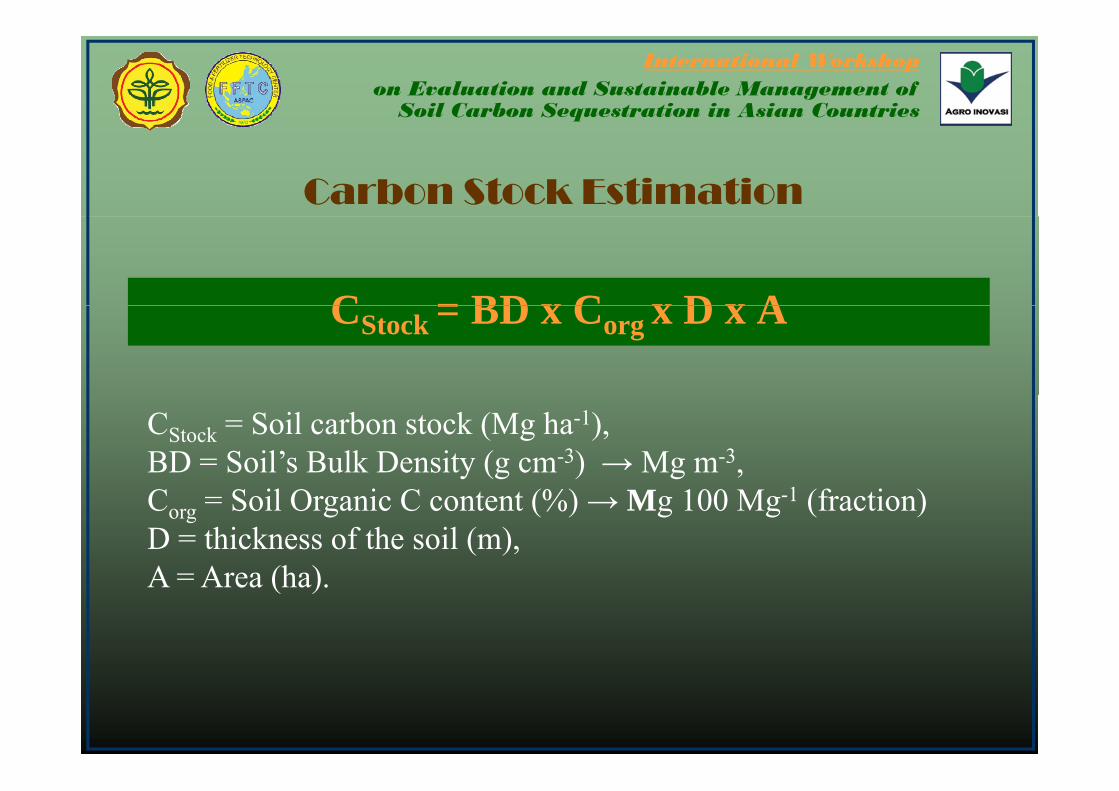
Carbon Stock Estimation
C = BD x C x D x ACStock = BD x Corg x D x A
CStock = Soil carbon stock (Mg ha-1),BD = Soil’s Bulk Density (g cm-3) → Mg m-3, Corg = Soil Organic C content (%) → Mg 100 Mg-1 (fraction) D = thickness of the soil (m),A = Area (ha)A = Area (ha).
International Workshopon Evaluation and Sustainable Management of
Soil Carbon Sequestration in Asian Countries
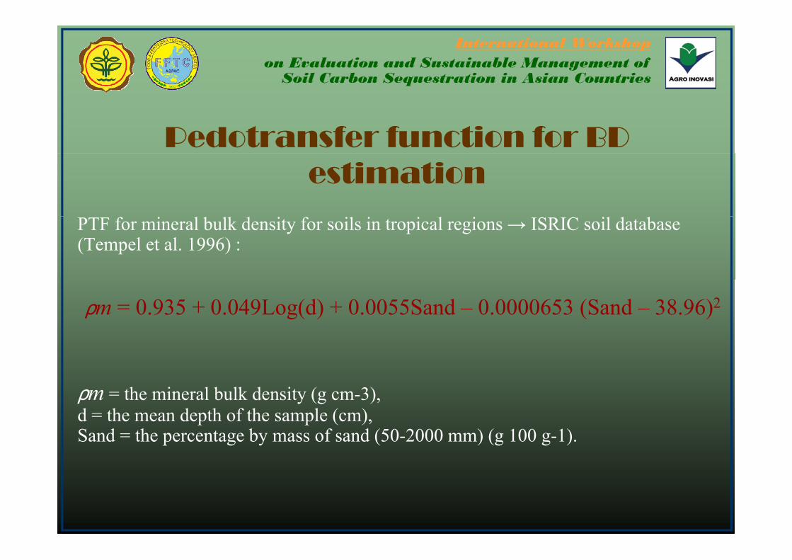
Pedotransfer function for BD estimation
PTF for mineral bulk density for soils in tropical regions → ISRIC soil database (Tempel et al. 1996) :
ρm = 0.935 + 0.049Log(d) + 0.0055Sand – 0.0000653 (Sand – 38.96)2
ρm = the mineral bulk density (g cm-3), d = the mean depth of the sample (cm), Sand = the percentage by mass of sand (50-2000 mm) (g 100 g-1).

International Workshopon Evaluation and Sustainable Management of
Soil Carbon Sequestration in Asian Countries
Pedotransfer function for BD
Bulk density (ρb) is then predicted from mineral bulk density adjusted for organic matter content (Adams, 1973):
OM% = organic matter mass percentage andOM% organic matter mass percentage, and ρOM = organic matter bulk density = 0.224 g cm-3.

International Workshopon Evaluation and Sustainable Management of
Soil Carbon Sequestration in Asian Countries
Estimate of Soil Carbon Estimate of Soil Carbon Stock in IndonesiaStock in Indonesia

Soil Carbon Stock (0-30 cm) & its parameter derived from Sumatra DatabaseSu at a atabase
Soil Order Bulk Density (Mg m-3) Soil Organic Carbon (% weight)
Soil Carbon Stock (Mg ha-1)
Average Range Average Range Average Used PDTAlfisols 1.23 + 0.08 1.07 – 1.31**) 1.43 + 0.73 0.35 - 2.69 42.31 + 20.13 37.02 + 5.89
E ti l 1 18 + 0 24 0 94 1 60**) 3 18 + 2 45 0 04 9 91 118 02 + 97 35 91 86 + 75 21Entisols 1.18 + 0.24 0.94 – 1.60**) 3.18 + 2.45 0.04 - 9.91 118.02 + 97.35 91.86 + 75.21
Histosols 0.44 + 0.04 0.1 – 0.8 *) 42.08 + 10.23 25.10 - 60.18 599.69 + 143.26 334.72 + 73.91
Inceptisols 1.16 + 0.16 0.91 - 1.36 2.34 + 1.57 0.09 - 9.84 70.42 + 47.74 67.41+ 50.55
Andisols 0.80 + 0.05 0.76 - 0.850.65 – 0.85*)
5.24 + 4.17 0.31 - 19.94 167.64 + 144.10 117.65 + 63.98
Mollisols 1.34 + 0.10 1.27 – 1.49**) 3.28 + 1.75 0.89 - 6.05 99.12 + 65.92 75.67 + 24.26
Oxisols 1.04 + 0.18 0.73 - 1.26 2.06 + 1.15 0.58 - 8.18 61.86 + 33.84 62.46 + 28.77
Spodosols 0.97 + 0.17 0.85 - 1.09 3.16 + 2.54 0.65 -10.39 84.78 + 85.87 60.35 + 32.03
Ultisols 1.16 + 0.11 1.00 – 1.31 1.86 + 1.38 0.15 - 9.87 61.30 + 44.77 54.56 + 29.25Ultisols 1.16 + 0.11 1.00 1.31 1.86 + 1.38 0.15 9.87 61.30 + 44.77 54.56 + 29.25
Sources : *) van Noordwijk et al. (1997), Wright and Hanlon (2009), FAO (2001); and **) Suprayogo et al. (2006), Seguel and Horn (2006)
International Workshopon Evaluation and Sustainable Management of
Soil Carbon Sequestration in Asian Countries
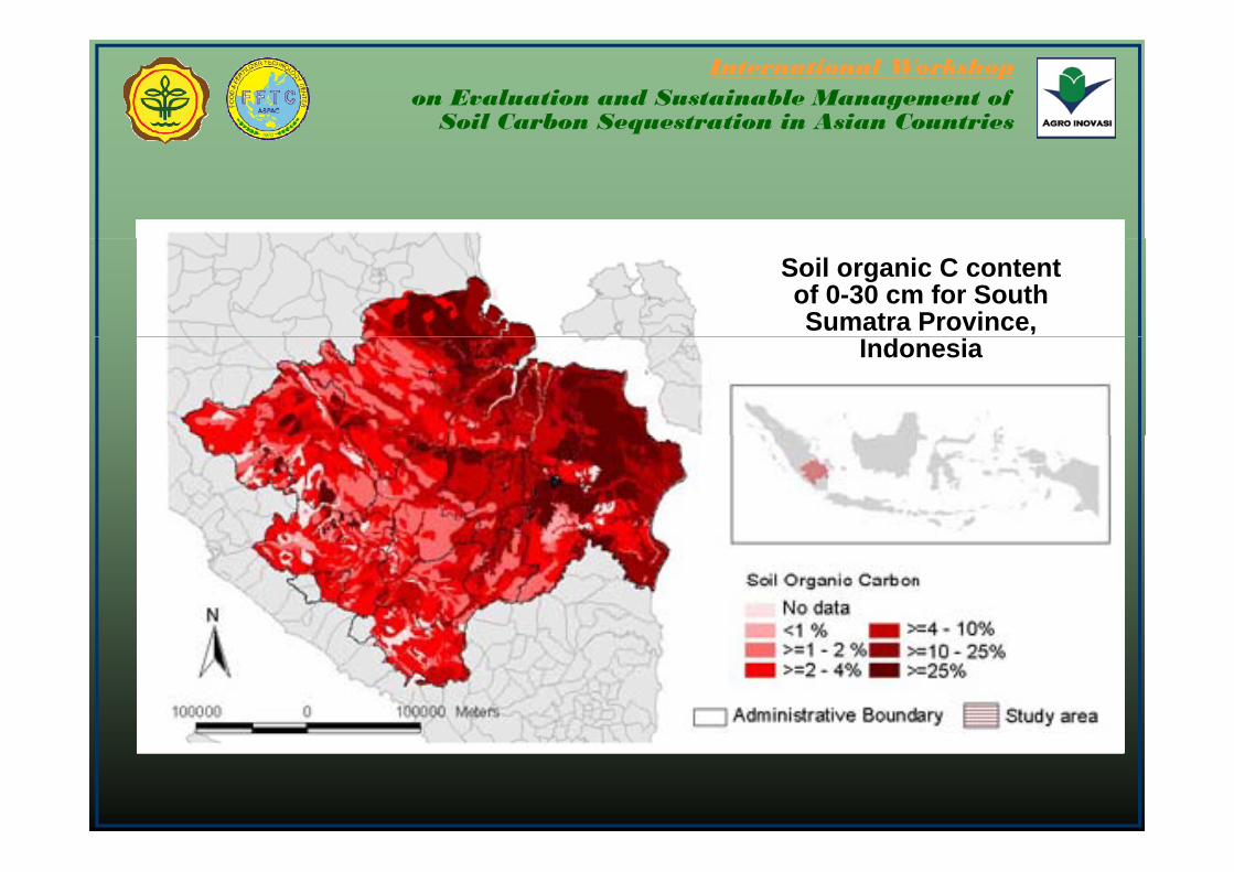
Soil organic C content of 0-30 cm for South Sumatra Province,
Indonesia

Soil Organic Carbon Stock of South SumateraSoil Organic Carbon Stock of South Sumatera
300350400450
0cm
050
100150200250
Mg/
ha/3
0
0
Alfi
sols
And
isol
s
Ent
isol
s
His
toso
ls
Ince
ptis
ols
Mol
lisol
s
Oxi
sols
Spo
doso
ls
Ulti
sols

International Workshopon Evaluation and Sustainable Management of
Soil Carbon Sequestration in Asian Countries
Soil organic C content of 0-30 cm, Indonesia

International Workshopon Evaluation and Sustainable Management of
Soil Carbon Sequestration in Asian Countries
Soil organic C stock of 0-30 cm, Indonesia

Land use and Carbon content relationship
Not enough information to separate different Land uses in current database room in current database room for future improvement
International Workshopon Evaluation and Sustainable Management of
Soil Carbon Sequestration in Asian Countries
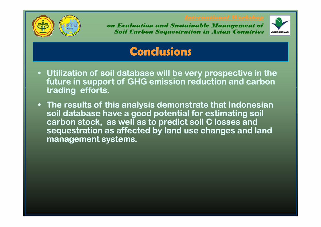
ConclusionsConclusions
•• Utilization of soil database will be very prospective in the Utilization of soil database will be very prospective in the future in support of GHG emission reduction and carbon future in support of GHG emission reduction and carbon t di ff t t di ff t trading efforts. trading efforts.
•• The results of this analysis demonstrate that Indonesian The results of this analysis demonstrate that Indonesian soil database have a good potential for estimating soil soil database have a good potential for estimating soil soil database have a good potential for estimating soil soil database have a good potential for estimating soil carbon stock, as well as to predict scarbon stock, as well as to predict soil C losses and oil C losses and sequestration as affected by land use changes and land sequestration as affected by land use changes and land management systemsmanagement systemsmanagement systems.management systems.

International Workshopon Evaluation and Sustainable Management of
Soil Carbon Sequestration in Asian Countries
ConclusionsConclusions
•• Limitation of ICALRD current land resources database :Limitation of ICALRD current land resources database :•• Bulk density measurement has not been consistently included in the Bulk density measurement has not been consistently included in the
current soil survey protocolcurrent soil survey protocolcurrent soil survey protocol.current soil survey protocol.•• The land use data contained in the current soil database has not been The land use data contained in the current soil database has not been
clearly identified and this limits our analysis in relating the change clearly identified and this limits our analysis in relating the change in land use and soil organic carbon content.in land use and soil organic carbon content.
•• Future soil surveys are strongly recommended to include bulk Future soil surveys are strongly recommended to include bulk density measurement and clear identification of land use landdensity measurement and clear identification of land use landdensity measurement and clear identification of land use land density measurement and clear identification of land use land management system of the point of observationmanagement system of the point of observation
•• Integration of soil database with other databases, such as climate is very Integration of soil database with other databases, such as climate is very useful for an improved analysis of soil carbon estimationuseful for an improved analysis of soil carbon estimationuseful for an improved analysis of soil carbon estimation.useful for an improved analysis of soil carbon estimation.
International Workshopon Evaluation and Sustainable Management of
Soil Carbon Sequestration in Asian Countries
AcknowledgmentAcknowledgment
OurOur gratitudegratitude goesgoes toto ::gg gg DrDr DD.. SubardjaSubardja ofof ICALRD,ICALRD, DrDr.. BudimanBudiman MinasnyMinasny ofof
UniversityUniversity ofof SydneySydney andand MrMr DavidDavid JacquierJacquier ofof CSIROCSIROUniversityUniversity ofof Sydney,Sydney, andand MrMr.. DavidDavid JacquierJacquier ofof CSIROCSIROCanberra,Canberra, AustraliaAustralia forfor adviceadvice && guidanceguidance forfor thisthis paperpaperwhichwhich werewere usefuluseful inin derivingderiving conclusionsconclusions..
MrMr.. SaefoelSaefoel BachriBachri andand MrMr.. AdiAdi PriyonoPriyono forfor preparingpreparing thethedatadata && analysisanalysis..yy
AllAll peoplepeople whowho havehave contributedcontributed toto thisthis paperpaper..

International Workshopon Evaluation and Sustainable Management of
Soil Carbon Sequestration in Asian Countries
Th k YThank You
ICALRDICALRD : : Jl. Ir. H. Juanda 98, Bogor 16123Jl. Ir. H. Juanda 98, Bogor 16123Telp +62 251 8323012Telp +62 251 8323012Telp. +62 251 8323012Telp. +62 251 8323012Fax. +62 251 8311256Fax. +62 251 8311256Email: [email protected]: [email protected]://bbsdlp.litbang.deptan.go.idhttp://bbsdlp.litbang.deptan.go.id