Embed Size (px)
Citation preview
W O R K I N G P A P E R
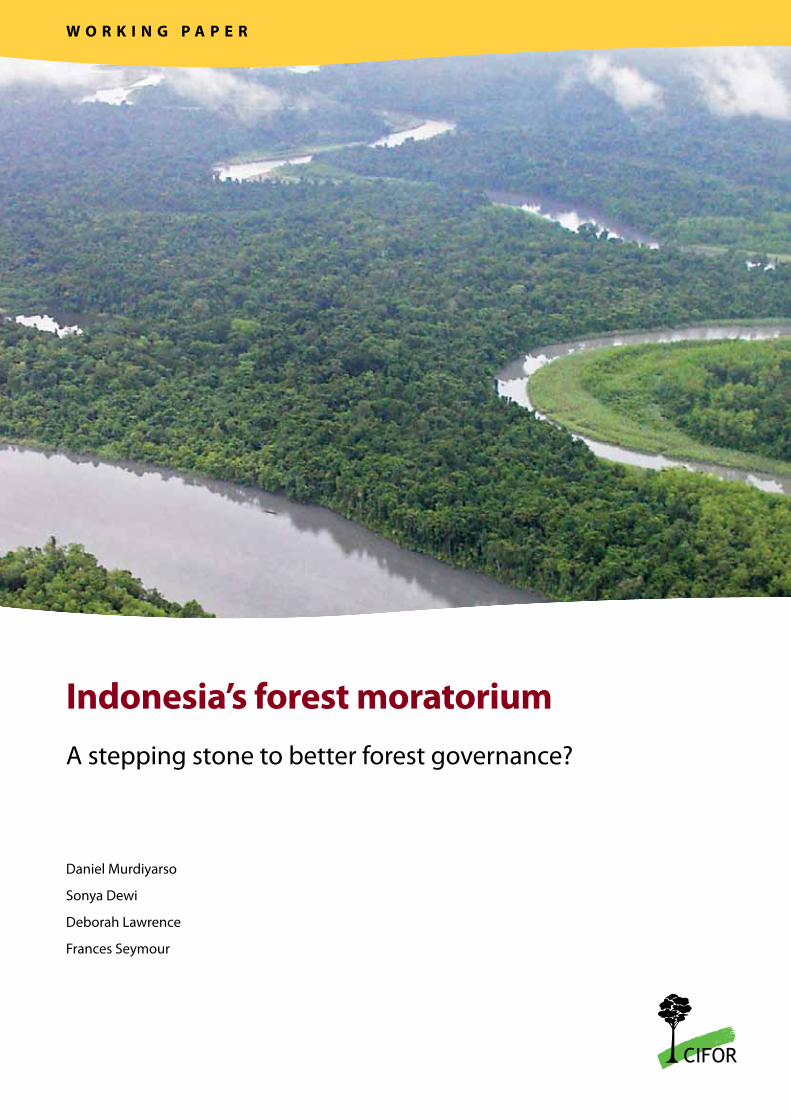
Indonesia’s forest moratoriumA stepping stone to better forest governance?
Daniel Murdiyarso
Sonya Dewi
Deborah Lawrence
Frances Seymour

Indonesia’s forest moratoriumA stepping stone to better forest governance?
Daniel MurdiyarsoCIFOR
Sonya DewiWorld Agroforestry Centre
Deborah LawrenceDepartment of Environmental Sciences, University of Virginia
Frances SeymourCIFOR
Working Paper 76
Working Paper 76
© 2011 Center for International Forestry Research All rights reserved
Murdiyarso, D., Dewi, S., Lawrence, D. and Seymour, F. 2011 Indonesia’s forest moratorium: a stepping stone to better forest governance? Working Paper 76. CIFOR, Bogor, Indonesia.
Cover photo by Daniel Murdiyarso
CIFORJl. CIFOR, Situ GedeBogor Barat 16115Indonesia
T +62 (251) 8622-622F +62 (251) 8622-100E [email protected]
www.cifor.org
Any views expressed in this publication are those of the authors. They do not necessarily represent the views of CIFOR, the authors’ institutions or the financial sponsors of this publication.
Table of contents
List of abbreviations ivPreface vAcknowledgements vi1 Background 12 What is the scope of the moratorium? 23 Why is the moratorium contested? 4 3.1 Confusing definitions 3.2 Inclusion of already-protected conservation and protection forest areas 3.3 Exceptions to the Inpres provisions4 What are the likely impacts of the moratorium? 7 4.1 Environmental impacts 4.2 Economic impacts5 The need for transparency and the way forward 96 Conclusions 127 References 13
List of figures, tables and boxes
Bappenas Badan Perencanaan dan Pembangunan Nasional (National Development Planning Agency)CA Conservation areaCO2 Carbon dioxideCOP Conference of the Parties (to the UNFCCC)EIA Environmental Impact AssessmentFAO Food and Agriculture Organization of the United NationsHCV High Conservation ValueIMM Indicative Moratorium MapInpres Presidential InstructionLoI Letter of Intent (between the governments of Indonesia and Norway)Mha Million hectaresMIFEE Merauke Integrated Food and Energy Estate (Papua)MRV Measurement, reporting and verificationREDD Reducing emissions from deforestation and forest degradationUKL Upaya Pengelolaan Lingkungan (Environmental Management Plan) UNFCCC United Nations Framework Convention on Climate ChangeUPL Upaya Pemantauan Lingkungan (Environmental Monitoring Plan)
List of abbreviations
Figures1. Venn diagram of primary forest, peatlands and areas classified as conservation and protection forests,
with the Indicative Moratorium Map superimposed 42a. Peat distribution by depth in Riau Province 82b. Peat distribution by depth with overlay of forest cover in Riau Province 82c. Peat distribution by depth in Central Kalimantan 82d. Peat distribution by depth with overlay of forest cover in Central Kalimantan 83. Low-hanging fruit: areas that offer opportunities to increase the gains from the moratorium,
in order of feasibility 11
Tables1. Area (Mha) of Indonesian islands uniquely protected under the moratorium, as shown by
a comparison of conservation area and Indicative Moratorium Map coverage 52. Distribution of peat by depth across 3 main islands of Indonesia (in thousands of hectares) 7
Boxes1. Recent changes in forest land status in Central Kalimantan 62. Using the moratorium to improve forest governance 12
On 20 May 2011, the government of Indonesia released Presidential Instruction (Inpres) No. 10/2011 on ‘The postponement of issuance of new licences and improving governance of primary natural forest and peatland’, as part of Indonesia’s cooperation with the government of the Kingdom of Norway, according to the Letter of Intent (LoI) signed by the two governments on 26 May 2010. The Inpres, which effectively imposes a 2-year moratorium on new forest concession licences, generated widespread public discourse and important policy implications.
This paper analyses the significance of the moratorium in the context of improving forest governance in Indonesia. It also aims to help interested observers interpret the concerns expressed by various stakeholder groups. We begin by examining the definitions and terms used in the Inpres and the LoI to highlight the complexity of the issues. Then, in response to the government’s call for feedback, we scrutinise the Indicative Moratorium Map (IMM) that accompanied the Inpres. Our analysis includes a particular focus on the challenges related to peatlands, a carbon-rich ecosystem for which governance is weak. We also attempt to draw a link between the moratorium and emission reductions because the moratorium has the potential to create enabling conditions for climate change mitigation, despite its limited scope and timeframe.
Finally, we hope that this analysis contributes to the process of revising the IMM which is now publicly available.
Daniel MurdiyarsoSonya DewiDeborah LawrenceFrances Seymour
Preface
Acknowledgements
This research would not have been possible without the generosity of the Directorate General of Planning (Ditjen Planologi), at the Ministry of Forestry, which upon our request provided access to digital forest cover maps. We would also like to express our gratitude for the significant contribution of colleagues at the Spatial Analysis Unit of the World Agroforestry Centre, Bogor, Indonesia.
Our thanks also go to Gary Paoli and Philip Wells of Daemeter Consulting, for their reviews of our work. Their critical comments and suggestions have improved the manuscript. We also thank Mubariq Achmad of the World Bank for his insightful feedback and input. Any errors remaining in this analysis are, of course, our responsibility.
We were also privileged to have had open discussions with several colleagues at the Ministry of Forestry, especially at the Forest Research and Development Agency (FORDA). We could achieve understanding and consensus on a number of issues, and we hope that this analysis will prove to be a point of departure for future collaborations.
This publication was made possible through the generous support of the Australian Agency for International Development, the Climate and Land Use Alliance, the Government of Norway and the World Agroforestry Centre.
1. BackgroundReducing emissions from deforestation and forest degradation (REDD) was adopted at the 13th Session of the Conference of the Parties (COP 13) to the United Nations Framework Convention on Climate Change (UNFCCC) as a global mechanism to mitigate climate change1. The mechanism, now called REDD+, encompasses a wider spectrum of activities, including forest conservation, sustainable management of forests and enhancement of carbon stocks through afforestation and reforestation2.
On 26 May 2010, the governments of the Republic of Indonesia and the Kingdom of Norway signed a Letter of Intent (LoI) on REDD+3. Under the LoI, Indonesia agreed to take several actions, including the following:
1 Decision 2/CP.13. Reducing emissions from deforestation in developing countries: approaches to stimulate action. FCCC/CP/2007/6/Add.1, pp. 8–11.2 Decision 2/CP.15. Copenhagen Accord. FCCC/CP/2009/11/Add, pp. 4–9.3 http://www.norway.or.id/PageFiles/404362/Letter_of_Intent_Norway_Indonesia_26_May_2010.pdf.
• develop a REDD+ National Strategy; • establish a dedicated agency to implement
the REDD+ strategy, including a system for measurement, reporting and verification (MRV) of emission reductions and financial instruments for disbursing funds; and
• develop and implement policy instruments and enforcement capability, including a 2-year suspension of all new concessions for conversion of peatland and natural forest areas to other uses.
These commitments were consistent with President Susilo Bambang Yudhoyono’s voluntary pledge announced the previous year to reduce Indonesia’s greenhouse gas emissions by 26% with domestic financial resources by 20204 or by 41% with international assistance. In return, the Norwegian government pledged up to US$1 billion to support Indonesia’s actions.
4 http://forestclimatecenter.org/files/2009-09-25%20Intervention%20by%20President%20SBY%20on%20Climate%20Change%20at%20the%20G-20%20Leaders%20Summit.pdf.
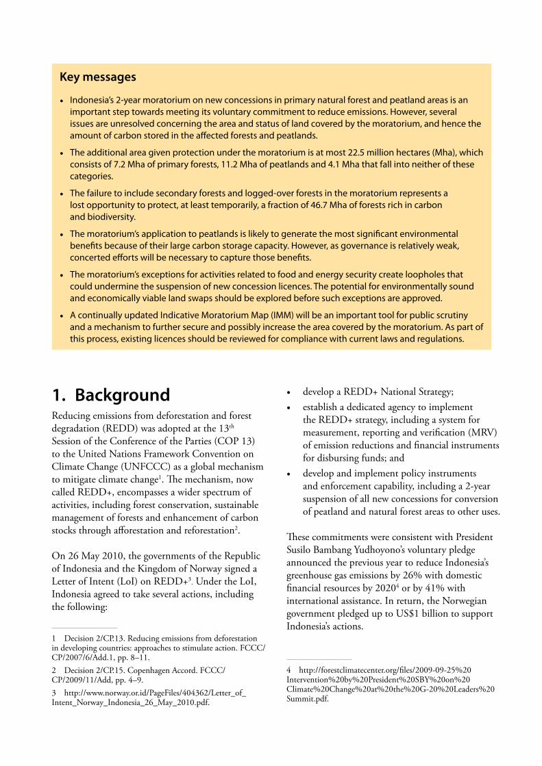
Key messages
• Indonesia’s 2-year moratorium on new concessions in primary natural forest and peatland areas is an important step towards meeting its voluntary commitment to reduce emissions. However, several issues are unresolved concerning the area and status of land covered by the moratorium, and hence the amount of carbon stored in the affected forests and peatlands.
• The additional area given protection under the moratorium is at most 22.5 million hectares (Mha), which consists of 7.2 Mha of primary forests, 11.2 Mha of peatlands and 4.1 Mha that fall into neither of these categories.
• The failure to include secondary forests and logged-over forests in the moratorium represents a lost opportunity to protect, at least temporarily, a fraction of 46.7 Mha of forests rich in carbon and biodiversity.
• The moratorium’s application to peatlands is likely to generate the most significant environmental benefits because of their large carbon storage capacity. However, as governance is relatively weak, concerted efforts will be necessary to capture those benefits.
• The moratorium’s exceptions for activities related to food and energy security create loopholes that could undermine the suspension of new concession licences. The potential for environmentally sound and economically viable land swaps should be explored before such exceptions are approved.
• A continually updated Indicative Moratorium Map (IMM) will be an important tool for public scrutiny and a mechanism to further secure and possibly increase the area covered by the moratorium. As part of this process, existing licences should be reviewed for compliance with current laws and regulations.
2 Daniel Murdiyarso, Sonya Dewi, Deborah Lawrence and Frances Seymour
Just one week before the first anniversary of the LoI, on 20 May 2011, a Presidential Instruction, known as Inpres No. 10/2011, was released, announcing a forest moratorium that would fulfil one of the LoI’s most closely watched agreed actions5. Inpres No. 10/2011 aims to suspend the granting of new concession licences for logging and conversion of forests and peatlands for two years from the date of enactment, with the suspension allowing for better planning for forest governance through the institution of necessary coordination processes, data collection and, potentially, new regulations.
Whilst CIFOR6 and others welcomed the moratorium as a step forward, two groups of stakeholders in particular greeted the announcement with dismay7.
First, elements of the business community (as well as some parliamentarians and bureaucrats) expressed fears that by imposing limitations on forest land-based development opportunities, the moratorium would curtail economic growth8. They asserted that the moratorium could jeopardise widely accepted pro-job and pro-poor development strategies.
Second, elements of the environmental community were disappointed by the narrow scope of the moratorium and its many exclusions and exceptions. They claimed that the moratorium would be ineffective in reducing carbon emissions and expressed concerns about the weakness of spatial/land use plans and forest governance, which are more broadly necessary to support the moratorium’s implementation9.
The purpose of this working paper is to help interested observers interpret the significance of the moratorium and the concerns expressed by various stakeholder groups. The analysis should be considered as a contribution to the Government of Indonesia’s efforts to make public and improve the Indicative
5 http://sipuu.setkab.go.id/PUUdoc/17176/INPRES0102011.pdf.6 CIFOR press release, 20 May 2011. Ban on new forest concessions in Indonesia is good news for climate change, but many challenges remain.7 The Jakarta Globe, 22 May 2011. Forest moratorium too harsh for some, too weak for others.8 Antara, 22 May 2011. GAPKI considers Inpres moratorium would trigger conflicts.9 Kompas, 26 May 2011. Inpres, political–economy compromises.
Moratorium Map (IMM) that accompanied the Inpres10.
2. What is the scope of the moratorium?An Inpres is a set of presidential instructions to concerned ministries and other government agencies. As a non-legislative document, there are no legal consequences if its instructions are not implemented. Inpres No. 10/2011 issues instructions to three ministers (Forestry, Home Affairs and Environment) and the heads of five agencies (Presidential Delivery Unit for Development Oversight, National Land Agency, National Coordination Agency for Spatial Planning, National Coordination Agency for Survey and Mapping and the proposed agency to manage REDD+), as well as governors and heads of district governments. The Inpres describes the tasks and the roles of each agency over a 2-year period.
Two important ministries closely related to deforestation and associated land-based emissions are not mentioned in the Inpres: the Ministries of Agriculture and Energy and Mineral Resources. Their exemption from the moratorium may be linked to their roles in securing the nation’s food and energy supply. The limited application of the moratorium to activity in these sectors could potentially weaken the government’s ability to fulfil the intention of the Inpres itself, as well as the President’s own commitment to reducing greenhouse gas emissions.
The Inpres applies to primary natural forests and peatlands. The newly introduced terminology of ‘primary natural forest’ – as opposed to ‘natural forests’, as used in the LoI – has been interpreted differently by different stakeholders. This new term reinforces the interpretation that the moratorium targets only untouched, unmanaged and undisturbed forests, whereas some had interpreted the LoI as encompassing a broader range of forests. The terminology adopted affects the scope of the moratorium because it excludes disturbed or secondary natural forests. The difference is substantial – as described further below, a broader definition of ‘natural’ would more than double the amount of
10 http://www.ukp.go.id/web/berita/10-umum/36-ajakan-kepada-masyarakat-untuk-memberikan-masukan-pembaharuan-peta-tutupan-hutan-dan-lahan-gambut.
Indonesia’s forest moratorium 3
forest area covered by the moratorium, depending on how much of that area is already under concessions11.
In contrast, the text on peatlands in the Inpres implies that the moratorium covers all peatlands regardless of their type, depth, location, jurisdiction or level of disturbance. Previously, only peatlands deeper than 3 m were protected from conversion to oil palm plantations under a Ministry of Agriculture regulation (No. 14/Permentan/FL.110/ 2/2009). Governors and district government heads, who issue the permits for oil palm development, may interpret the Inpres as superseding that ministerial regulation.
With regard to the total area of land covered by the moratorium, various government representatives have made statements that are not all mutually consistent. Soon after the Inpres was announced, the President’s Adviser on Climate Change told the public that the total land covered would be as much as 64 Mha12. The Secretary-General of the Ministry of Forestry later publicly stated that it could cover about 72 Mha, consisting of 55 Mha of primary forest and 17 Mha of peatlands – much less than an earlier announcement of 96 Mha13. The basis for these figures is not readily apparent (Wells and Paoli 2011). An independent digital version of the IMM that accompanied the announcement of the Inpres suggested that the moratorium covered no more than 46 Mha14. Analysis undertaken for this paper on the most recent version of the IMM – made available to the public on 5 August 2011 – suggests that the spatial extent of the Inpres is an estimated 66.4 Mha.
Environmental gains due to the moratorium are smaller than might have been expected, in terms of both the area of affected land not already protected
11 The total area of all forested land in Indonesia in 2009 was 91.9 Mha (at least 85.6 Mha of state forest land and 6.2 Mha of land for other uses, or ‘APL’). Of this area, primary forest accounted for 45.2 Mha. Much of this primary forest was already protected by existing law, which further reduces the additional area protected under the moratorium. If even half of the approximately 46.7 Mha of non-primary forest had been protected, the area covered by the moratorium would have been substantially increased.12 The Jakarta Globe, 20 May 2011. SBY signs decree on 2-year deforestation moratorium; The Jakarta Post, 20 May 2011. Moratorium issued to protect primary forests, peatland.13 The Jakarta Post, 5 July 2011. Govt reduces area of forests protected by moratorium.14 http://www.greenpeace.org/seasia/id/blog/pak-presiden-sby-kami-akan-memberitahu-siapa-/blog/35150p.
and the prospective emissions avoided. To obtain more precise estimates for both of these, we overlaid a digital map of primary forest constructed from land use/cover interpretation of Landsat images acquired in 2009 (Ministry of Forestry 2011) on a digital map of areas designated as conservation or protection forests as of 2009 (Ministry of Forestry 2009). The land use/cover maps were provided to CIFOR by the Ministry of Forestry upon request in 2011. We also overlaid digital peatland maps provided by Wetlands International (2003, 2004, 2006). We then superimposed the most recent version of the IMM.
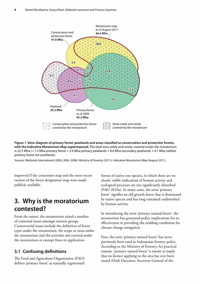
As shown in Figure 1, in 2009, primary forest and peatlands in Indonesia covered an area of 60.1 Mha. As much of this area is already legally protected, the moratorium provides additional coverage to 22.5 Mha (7.2 Mha of primary forests, 11.2 Mha of peatlands and an ‘additional’ 4.1 Mha15 that do not fall into either category).
The remaining 5.8 Mha of peatlands (29% of the country’s total peatlands) is not included in the IMM, presumably because of existing permits issued prior to the Inpres, or the expected exclusion of areas to be allocated for activities related to food and energy security. Also excluded from the IMM is 9.6 Mha of primary forest (21% of total remaining primary forest), of which 4.1 Mha is limited production forest, 3.4 Mha is production forest and 1.8 Mha is convertible forest. Similarly to the peatland case, these primary forest areas are most likely under concessions granted prior to the Inpres, even though in reality they have not yet been disturbed or allocated for activities related to food or energy security.
Exempt from the moratorium are existing concession licences and those that had been approved in principle before the Inpres was announced. As current concession maps are not publicly available, we cannot overlay them on available maps or include them in the analysis in the Venn diagram (Figure 1). It is possible that these licensed areas overlap with the IMM. The transparency of the IMM would be
15 This discrepancy occurs because, in conducting this analysis, we used a different version of the forest designation map (Ministry of Forestry 2009) from that used by the Ministry of Forestry to produce the IMM. The complete version of this latter map has not yet been made available to the public.
4 Daniel Murdiyarso, Sonya Dewi, Deborah Lawrence and Frances Seymour
improved if the concession map and the most recent version of the forest designation map were made publicly available.
3. Why is the moratorium contested?From the outset, the moratorium raised a number of contested issues amongst interest groups. Controversial issues include the definition of forest types under the moratorium, the scope or areas under the moratorium and the activities not covered under the moratorium or exempt from its application.
3.1 Confusing definitionsThe Food and Agriculture Organization (FAO) defines ‘primary forest’ as naturally regenerated
forests of native tree species, in which there are no clearly visible indications of human activity and ecological processes are not significantly disturbed (FAO 2010a). In many cases, the term ‘primary forest’ signifies an old growth forest that is dominated by native species and has long remained undisturbed by human activity.
In introducing the term ‘primary natural forest’, the moratorium has generated policy implications for its effectiveness in providing the enabling conditions for climate change mitigation.
First, the term ‘primary natural forest’ has never previously been used in Indonesian forestry policy. According to the Ministry of Forestry, for practical reasons, ‘primary natural forest’ is meant to imply that no licence applying to the area has ever been issued (Hadi Daryanto, Secretary-General of the
4.71.1
18.0
9.6
22.8
2.6
1.5 1.6
0.010.1
3.4
4.1
8.6
0.3
7.2
4.71.1
18.0
9.6
22.8
2.6
1.5 1.6
0.010.1
3.4
4.1
8.6
0.3
7.2
Primary forest as of 200945.2 Mha
Conservation and protection forest covered by the moratorium
Areas solely and newly covered by the moratorium
Peatland20.2 Mha
Moratorium map as of August 201166.4 MhaConservation and
protection forest47.8 Mha
Figure 1. Venn diagram of primary forest, peatlands and areas classified as conservation and protection forests, with the Indicative Moratorium Map superimposed. The total area solely and newly covered under the moratorium is 22.5 Mha (= 7.2 Mha primary forest + 2.6 Mha primary peatlands + 8.6 Mha secondary peatlands + 4.1 Mha neither primary forest nor peatlands).
Sources: Wetlands International (2003, 2004, 2006), Ministry of Forestry (2011), Indicative Moratorium Map (August 2011).
Indonesia’s forest moratorium 5
Ministry of Forestry, personal communication 2011). The ministry adopted the term ‘primary forest’, as defined by the FAO, for reporting purposes. Indonesia’s country report to the FAO interprets the term as applying to forests characterised by the absence of logging roads evident in remotely sensed imagery, regardless of whether the area is covered by a concession licence (FAO 2010b). As the moratorium is implemented and evaluated, use of the term ‘primary natural forest’ could create discrepancies with the term used in the LoI (‘natural forest’) in determining the scope of the moratorium.
Second, by design, the terminology used in the moratorium excludes secondary or logged-over forests, which might be best managed as forest rather than converted to other uses. According to the Ministry of Forestry (2009), as of 2009, Indonesia had a total of 45.2 Mha of primary forest, 41.4 Mha of secondary forest in state forest land and 5.3 Mha of forested areas outside state forest land, which are assumed to be predominantly secondary forest.
With secondary forest making up more than half of Indonesia’s forest area, most of the biomass and a large proportion of key species remain in the landscape. Secondary forests have higher carbon stocks than oil palm or fibre plantations (Murdiyarso et al. 2002). In most cases, they also have greater biodiversity (Danielsen et al. 2008, Koh and Wilcove 2008). Thus, the failure to include in the moratorium secondary forests and forests not under the Ministry of Forestry’s control represents a lost opportunity to protect, at least temporarily, an additional 46.7 Mha of forests rich in carbon and biodiversity.
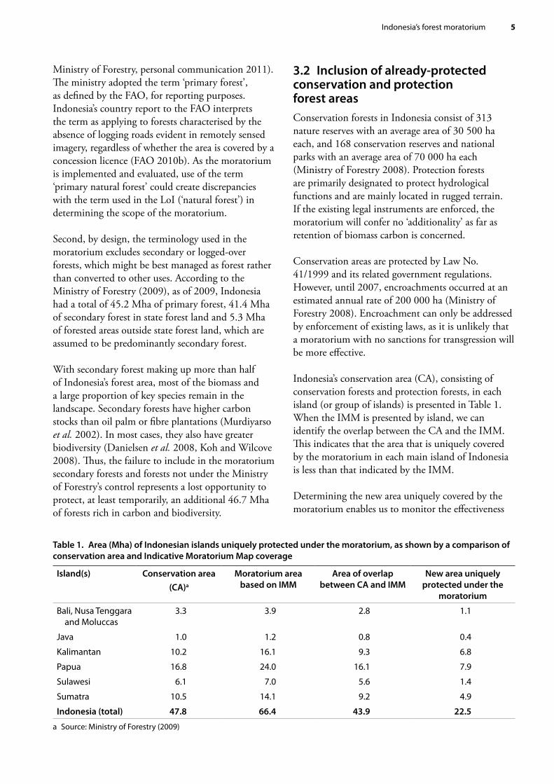
3.2 Inclusion of already-protected conservation and protection forest areasConservation forests in Indonesia consist of 313 nature reserves with an average area of 30 500 ha each, and 168 conservation reserves and national parks with an average area of 70 000 ha each (Ministry of Forestry 2008). Protection forests are primarily designated to protect hydrological functions and are mainly located in rugged terrain. If the existing legal instruments are enforced, the moratorium will confer no ‘additionality’ as far as retention of biomass carbon is concerned.
Conservation areas are protected by Law No. 41/1999 and its related government regulations. However, until 2007, encroachments occurred at an estimated annual rate of 200 000 ha (Ministry of Forestry 2008). Encroachment can only be addressed by enforcement of existing laws, as it is unlikely that a moratorium with no sanctions for transgression will be more effective.
Indonesia’s conservation area (CA), consisting of conservation forests and protection forests, in each island (or group of islands) is presented in Table 1. When the IMM is presented by island, we can identify the overlap between the CA and the IMM. This indicates that the area that is uniquely covered by the moratorium in each main island of Indonesia is less than that indicated by the IMM.
Determining the new area uniquely covered by the moratorium enables us to monitor the effectiveness
Table 1. Area (Mha) of Indonesian islands uniquely protected under the moratorium, as shown by a comparison of conservation area and Indicative Moratorium Map coverage
Island(s) Conservation area(CA)a
Moratorium area based on IMM
Area of overlap between CA and IMM
New area uniquely protected under the
moratorium
Bali, Nusa Tenggara and Moluccas
3.3 3.9 2.8 1.1
Java 1.0 1.2 0.8 0.4
Kalimantan 10.2 16.1 9.3 6.8
Papua 16.8 24.0 16.1 7.9
Sulawesi 6.1 7.0 5.6 1.4
Sumatra 10.5 14.1 9.2 4.9
Indonesia (total) 47.8 66.4 43.9 22.5
a Source: Ministry of Forestry (2009)
6 Daniel Murdiyarso, Sonya Dewi, Deborah Lawrence and Frances Seymour
of the moratorium and the subsequent emission reduction efforts in each island and other subnational domains. Furthermore, separating the area covered by the moratorium from areas already under conservation may make it possible to evaluate how the moratorium is implemented at subnational levels and to identify potential transgressions.
3.3 Exceptions to the Inpres provisionsArticle 2 of the Inpres sets out 4 exceptions. Of these, the first 3 are potentially counter-productive in terms of meeting emission reduction targets. Depending on how liberally the concession licences are granted, these exceptions could substantially weaken the effectiveness of the moratorium.
First, the Inpres exempts forests covered by applications for concession licences already ‘approved in principle’ by the Minister of Forestry, regardless of their richness in carbon, biodiversity or other ecosystem services.
Second, the Inpres exempts land needed for ‘vital’ national development projects (defined as geothermal, oil and natural gas, electricity, rice
and sugarcane), regardless of their proximity to conservation areas. Activities necessary to meet the demand for more electricity could be interpreted as including the expansion of coal mining. In Central Kalimantan Province, for example, exploration and exploitation of coal are often associated with licensed production forestry (see Box 1).
The exceptions also mean that the implementation of the moratorium must be made compatible and consistent with Inpres No. 5/2011 on food security, which instructs: 1. the Minister of Agriculture to expand the area of
food production;2. the Minister of Forestry to allow the use of forest
land for that purpose; and3. the Minister of Public Works to build
infrastructure to support rice production and transportation.
For example, in Papua, more than 1 Mha of land allocated for conversion to rice and sugarcane as part of the Merauke Integrated Food and Energy Estate (MIFEE) could be exempted from the moratorium.
Box 1. Recent changes in forest land status in Central Kalimantan
Government Regulation (PP 24/2010) permits logging concessions to be ‘borrowed and used’ (pinjam-pakai) for mining activities in up to 10% of production forests that have mineral/coal deposits. A prohibition applies only to conservation forests; underground mining is still permitted in protection forests.
The implications of this policy for greenhouse gas emissions are substantial. With logging, a fraction of aboveground biomass is removed and should recover as the forest regenerates, resulting in limited net emissions. With open-cut mining, however, all biomass, both above and below the ground, is removed, emitting more carbon dioxide per unit area. Furthermore, the rate of recovery in terms of carbon sequestration and biomass accumulation in mining-degraded lands is slow.
Since 2008, 39 borrowed-and-used licences have been issued for mining in Central Kalimantan. Most were issued in 2010 but seven were issued in 2011 before Inpres No. 10/2011 was enacted. Overall, the licences cover 161 502 ha, of which 8895 ha was allocated for mining in 2011.
The delay in signing the moratorium raised widespread public concern about the integrity of the Inpres because of the apparent rush of licences issued during the five months between the initial deadline for the Inpres and its eventual release (January–May 2011). The fact that the moratorium is not retroactive to 1 January 2011, its original target date, rewards those who took advantage of the opportunity to obtain licences during this period.
Eleven days after the moratorium took effect, a new Ministerial Decree (SK 292/Menhut II/2011) was issued, changing the status of almost 1.2 Mha of state forest land into land for other uses. The same decree allows for the reverse to occur, but only 30 000 ha of non-forest was re-categorised as forest land. All the changes occurred in Central Kalimantan, recently selected as the pilot province under the LoI.
Indonesia’s forest moratorium 7
Third, the Inpres excludes the extension of existing licences for forest exploitation and/or forest-area use as long as the licence for the business remains valid, regardless of the licence-holder’s performance under the existing licence or its environmental integrity.
In contrast, the fourth exception – for ecosystem restoration – is potentially quite positive, as it creates a new opportunity to enhance carbon stocks through afforestation/reforestation. Ecosystem restoration concessions would grant concessionaires rights to the land for 65 years with a possible 35-year extension. This kind of arrangement could help resolve permanence issues that must be addressed if land is to be developed for REDD+ financing.
4. What are the likely impacts of the moratorium?4.1 Environmental impacts Peatlands receive special attention in the moratorium because of their significant role in storing carbon and providing other environmental services, including water and biodiversity conservation. Indeed, the main positive environmental impacts of the moratorium stem from the additional protection that it extends to this ecosystem.
Indonesian peatlands cover around 20.2 Mha, distributed across Sumatra, Kalimantan and Papua with varying depth and bulk density. They are estimated to store more than 30 billion tonnes of carbon (Ministry of Forestry 2008). Papua harbours the largest area of peatlands, most of which are shallow. In contrast, Kalimantan has the smallest area, but with deep, very deep and extremely deep peat, as illustrated in Table 2.
Depending on the peat depth, the carbon density in forested peatlands can be as much as 5–10 times that of forested mineral soils per unit area. Therefore, protecting peatlands would represent a significant gain in terms of reduced emissions and other environmental benefits. However, only 4.2 Mha of the peat covered by the moratorium remains under primary forest cover. Depending on the control of fires and alteration of water regimes of disturbed peatlands, carbon dioxide (CO2) emissions will continue even if the moratorium limits further degradation of aboveground vegetation. Non-forested peatlands, which cover 9.5 Mha (6.2 Mha under the moratorium and 3.3 Mha not covered by the moratorium), are at the greatest risk of further degradation, followed by logged-over forest on peat, which covers 5.4 Mha (3.9 Mha under the moratorium and 1.5 Mha not covered by the moratorium).
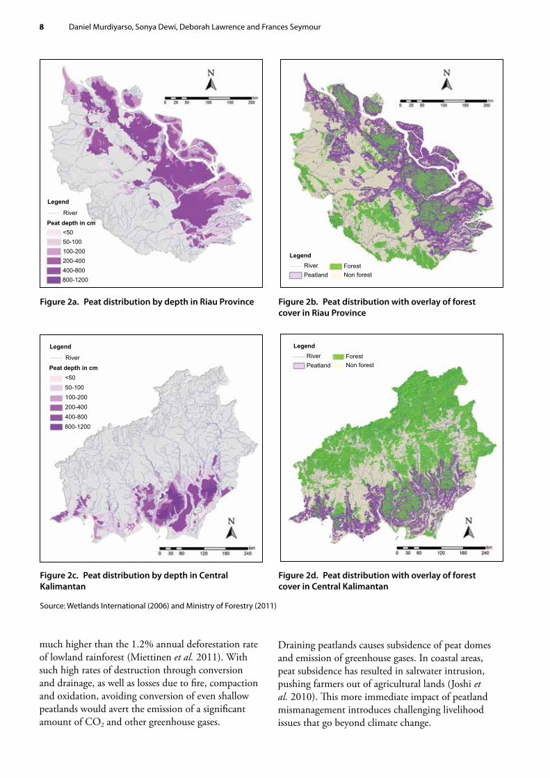
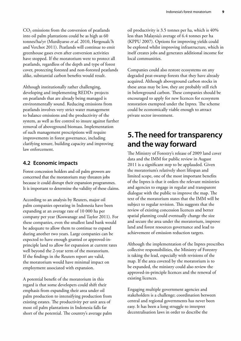
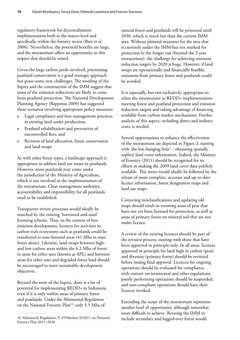
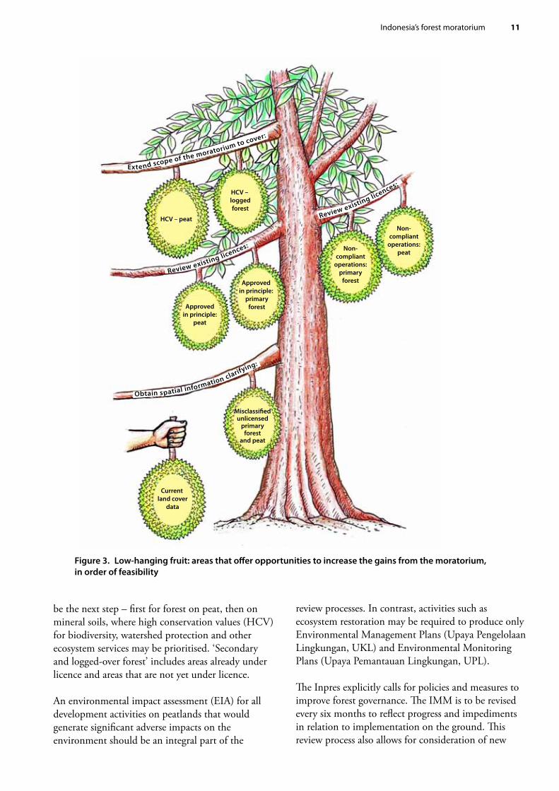
Most of the peat in Sumatra, including the deep peat, is located in Riau Province; in Kalimantan, deep peat is located in Central Kalimantan. These two provinces account for 19.4% and 14.9% of Indonesia’s total peatlands, respectively (Figures 2a, 2b, 2c and 2d). In addition, these provinces harbour a substantial amount of non-forested peatlands. Therefore, the implementation of the moratorium and revisions of the IMM should prioritise forest growing on peatlands and non-forested peatlands under the Ministry of Forestry’s jurisdiction, with special attention to these 2 provinces.
The deforestation rate for forested peatlands during 2000–2005 was around 100 000 ha per year. Most of the deforested and degraded deep peat is located in Riau Province, Sumatra (Ministry of Forestry 2008). A recent study shows that the rate of deforestation of peat-swamp forests of insular Southeast Asia (mainly Indonesia) during 2000–2010 was 2.2% per year,
Table 2. Distribution of peat by depth across 3 main islands of Indonesia (in thousands of hectares)
Island Very shallow(<50 cm)
Shallow(50–100 cm)
Moderate(100–200 cm)
Deep(200–400 cm)
Very deep(400–800 cm)
Extremely deep (>800 cm)
Total
Sumatra 675 1 236 2 253 1 234 1 698 – 7 097Kalimantan 183 1 727 1 387 1 105 1 061 279 5 743Papua 174 4 923 650 1 683 – – 7 431Total 1 032 7 887 4 291 4 021 2 759 279 20 270
Sources: Wetlands International (2003, 2004, 2006)
8 Daniel Murdiyarso, Sonya Dewi, Deborah Lawrence and Frances Seymour
much higher than the 1.2% annual deforestation rate of lowland rainforest (Miettinen et al. 2011). With such high rates of destruction through conversion and drainage, as well as losses due to fire, compaction and oxidation, avoiding conversion of even shallow peatlands would avert the emission of a significant amount of CO2 and other greenhouse gases.
Draining peatlands causes subsidence of peat domes and emission of greenhouse gases. In coastal areas, peat subsidence has resulted in saltwater intrusion, pushing farmers out of agricultural lands (Joshi et al. 2010). This more immediate impact of peatland mismanagement introduces challenging livelihood issues that go beyond climate change.
Figure 2a. Peat distribution by depth in Riau Province
Figure 2c. Peat distribution by depth in Central Kalimantan
Figure 2b. Peat distribution with overlay of forest cover in Riau Province
Figure 2d. Peat distribution with overlay of forest cover in Central Kalimantan
Source: Wetlands International (2006) and Ministry of Forestry (2011)
LegendRiverPeatland
ForestNon forest
Legend
Peat depth in cmRiver
<5050-100100-200200-400400-800800-1200
LegendRiverPeatland
ForestNon forest
Legend
Peat depth in cmRiver
<5050-100100-200200-400400-800800-1200
Indonesia’s forest moratorium 9
CO2 emissions from the conversion of peatlands into oil palm plantations could be as high as 60 tonnes/ha/yr (Murdiyarso et al. 2010, Hergoualc’h and Verchot 2011). Peatlands will continue to emit greenhouse gases even after conversion activities have stopped. If the moratorium were to protect all peatlands, regardless of the depth and type of forest cover, protecting forested and non-forested peatlands alike, substantial carbon benefits would result.
Although institutionally rather challenging, developing and implementing REDD+ projects on peatlands that are already being managed is environmentally sound. Reducing emissions from peatlands involves very strict water management to balance emissions and the productivity of the system, as well as fire control to insure against further removal of aboveground biomass. Implementation of such management prescriptions will require improvements in forest governance, including clarifying tenure, building capacity and improving law enforcement.
4.2 Economic impactsForest concession holders and oil palm growers are concerned that the moratorium may threaten jobs because it could disrupt their expansion programmes. It is important to determine the validity of these claims.
According to an analysis by Reuters, major oil palm companies operating in Indonesia have been expanding at an average rate of 10 000 ha per company per year (Koswanage and Taylor 2011). For these companies, even the smallest land bank would be adequate to allow them to continue to expand during another two years. Large companies can be expected to have enough granted or approved-in-principle land to allow for expansion at current rates well beyond the 2-year term of the moratorium. If the findings in the Reuters report are valid, the moratorium would have minimal impact on employment associated with expansion.
A potential benefit of the moratorium in this regard is that some developers could shift their emphasis from expanding their area under oil palm production to intensifying production from existing estates. The productivity per unit area of most oil palm plantations in Indonesia falls far short of the potential. The country’s average palm
oil productivity is 3.5 tonnes per ha, which is 40% less than Malaysia’s average of 6.4 tonnes per ha (KPPU 2007). Options for improving yields could be explored whilst improving infrastructure, which in itself creates jobs and generates additional income for local communities.
Companies could also restore ecosystems on any degraded peat-swamp forests that they have already acquired. Although aboveground carbon stocks in these areas may be low, they are probably still rich in belowground carbon. These companies should be encouraged to apply for new licences for ecosystem restoration exempted under the Inpres. The scheme could be economically viable enough to attract private sector investment.
5. The need for transparency and the way forwardThe Ministry of Forestry’s release of 2009 land cover data and the IMM for public review in August 2011 is a significant step to be applauded. Given the moratorium’s relatively short lifespan and limited scope, one of the most important benefits of the Inpres is that it orders the relevant ministries and agencies to engage in regular and transparent dialogue with the public to improve the map. The text of the moratorium states that the IMM will be subject to regular revision. This suggests that the review of existing concession licences and better spatial planning could eventually change the size and secure the area under the moratorium, improve land and forest resources governance and lead to achievement of emission reduction targets.
Although the implementation of the Inpres prescribes collective responsibilities, the Ministry of Forestry is taking the lead, especially with revisions of the map. If the area covered by the moratorium is to be expanded, the ministry could also review the approved-in-principle licences and the renewal of existing licences.
Engaging multiple government agencies and stakeholders is a challenge; coordination between central and regional governments has never been easy. It has been a long struggle to interpret decentralisation laws in order to describe the
10 Daniel Murdiyarso, Sonya Dewi, Deborah Lawrence and Frances Seymour
regulatory framework for decentralisation implementation both at the macro-level and specifically within the forestry sector (Barr et al. 2006). Nevertheless, the potential benefits are large, and the moratorium offers an opportunity in this respect that should be seized.
Given the large carbon pools involved, prioritising peatland conservation is a good strategic approach but poses some new challenges. The wording of the Inpres and the construction of the IMM suggest that most of the emission reductions are likely to come from peatland protection. The National Development Planning Agency (Bappenas 2009) has suggested three scenarios involving appropriate policy measures: • Legal compliance and best management practices
in existing land under production; • Peatland rehabilitation and prevention of
uncontrolled fires; and • Revision of land allocation, forest conservation
and land swaps.
As with other forest types, a landscape approach is appropriate to address land use issues in peatlands. However, most peatlands may come under the jurisdiction of the Ministry of Agriculture, which is not involved in the implementation of the moratorium. Clear management authority, accountability and responsibility for all peatlands need to be established.
Transparent review processes would ideally be matched by the existing ‘borrowed-and-used’ licensing scheme. Thus, in the context of low-emission development, licences for activities in carbon-rich ecosystems such as peatlands could be transferred to non-forested areas (41 Mha in state forest alone). Likewise, land swaps between high- and low-carbon areas within the 6.2 Mha of forest in areas for other uses (known as APL) and between areas for other uses and degraded forest land should be encouraged to meet sustainable development objectives.
Beyond the term of the Inpres, there is a lot of potential for implementing REDD+ in Indonesia, even if it is only within areas of primary forest and peatlands. Under the Ministerial Regulation on the National Forestry Plan16, only 5.5 Mha of
16 Ministerial Regulation, P. 49/Menhut II/2011 on National Forestry Plan 2011–2030.
natural forest and peatlands will be protected until 2030, which is much less than the current IMM area. Without planned measures for the area that is currently under the IMM but not marked for protection in the longer run (beyond the 2-year moratorium), the challenge for achieving emission reduction targets by 2020 is huge. However, if land swaps are operationally and financially feasible, emissions from primary forest and peatlands could be avoided.
It is especially, but not exclusively, appropriate to relate the moratorium to REDD+ implementation: meeting forest and peatland protection and emission reduction targets and taking advantage of financing available from carbon market mechanisms. Further analysis of this aspect, including direct and indirect costs, is needed.
Several opportunities to enhance the effectiveness of the moratorium are depicted in Figure 3, starting with ‘the low-hanging fruit’ – obtaining spatially explicit land cover information. Indeed, the Ministry of Forestry (2011) should be recognised for its efforts in making the 2009 land cover data publicly available. This move would ideally be followed by the release of more complete, accurate and up-to-date licence information, forest designation maps and land use maps.
Correcting misclassifications and updating old maps should result in rezoning areas of peat that have not yet been licensed for protection, as well as areas of primary forest on mineral soil that are not under licence.
A review of the existing licences should be part of the revision process, starting with those that have been approved in principle only. In all areas, licences approved in principle for land high in carbon (peat) and diversity (primary forest) should be revisited before issuing final approval. Licences for ongoing operations should be evaluated for compliance with current environmental and other regulations; poorly performing operations should be suspended, and non-compliant operations should have their licences revoked.
Extending the scope of the moratorium represents another level of opportunity, although somewhat more difficult to achieve. Revising the IMM to include secondary and logged-over forest would
Indonesia’s forest moratorium 11
be the next step – first for forest on peat, then on mineral soils, where high conservation values (HCV) for biodiversity, watershed protection and other ecosystem services may be prioritised. ‘Secondary and logged-over forest’ includes areas already under licence and areas that are not yet under licence.
An environmental impact assessment (EIA) for all development activities on peatlands that would generate significant adverse impacts on the environment should be an integral part of the
review processes. In contrast, activities such as ecosystem restoration may be required to produce only Environmental Management Plans (Upaya Pengelolaan Lingkungan, UKL) and Environmental Monitoring Plans (Upaya Pemantauan Lingkungan, UPL).
The Inpres explicitly calls for policies and measures to improve forest governance. The IMM is to be revised every six months to reflect progress and impediments in relation to implementation on the ground. This review process also allows for consideration of new
Extend scope of the moratorium to cover:
Review existing licences:
Obtain spatial information clarifying:
Review existing licences:
HCV – peat
Approvedin principle:
peat
Approved in principle:
primaryforest
Non-compliant
operations:peatNon-
compliantoperations:
primaryforest
HCV – loggedforest
Misclassi�edunlicensed
primaryforest
and peat
Current land cover
data
Figure 3. Low-hanging fruit: areas that offer opportunities to increase the gains from the moratorium, in order of feasibility
12 Daniel Murdiyarso, Sonya Dewi, Deborah Lawrence and Frances Seymour
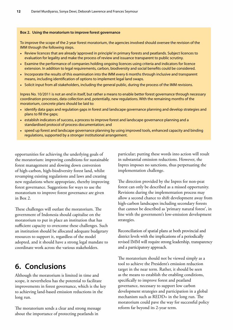
opportunities for achieving the underlying goals of the moratorium: improving conditions for sustainable forest management and slowing down conversion of high-carbon, high-biodiversity forest land, whilst revamping existing regulations and laws and creating new regulations where appropriate, thereby improving forest governance. Suggestions for ways to use the moratorium to improve forest governance are given in Box 2.
These challenges will outlast the moratorium. The government of Indonesia should capitalise on the moratorium to put in place an institution that has sufficient capacity to overcome these challenges. Such an institution should be allocated adequate budgetary resources to support it, regardless of the model adopted, and it should have a strong legal mandate to coordinate work across the various stakeholders.
6. ConclusionsAlthough the moratorium is limited in time and scope, it nevertheless has the potential to facilitate improvements in forest governance, which is the key to achieving land-based emission reductions in the long run.
The moratorium sends a clear and strong message about the importance of protecting peatlands in
particular; putting these words into action will result in substantial emission reductions. However, the Inpres imposes no sanctions, thus perpetuating the implementation challenge.
The direction provided by the Inpres for non-peat forest can only be described as a missed opportunity. Revisions during the implementation process may allow a second chance to shift development away from high-carbon landscapes including secondary forests that cannot be described as ‘primary natural forest’, in line with the government’s low-emission development strategies.
Reconciliation of spatial plans at both provincial and district levels with the implications of a periodically revised IMM will require strong leadership, transparency and a participatory approach.
The moratorium should not be viewed simply as a tool to achieve the President’s emission reduction target in the near term. Rather, it should be seen as the means to establish the enabling conditions, specifically to improve forest and peatland governance, necessary to support low carbon development strategies and participation in a global mechanism such as REDD+ in the long run. The moratorium could pave the way for successful policy reform far beyond its 2-year term.
Box 2. Using the moratorium to improve forest governance
To improve the scope of the 2-year forest moratorium, the agencies involved should oversee the revision of the IMM through the following steps. • Review licences that are already ‘approved in principle’ in primary forests and peatlands. Subject licences to
evaluation for legality and make the process of review and issuance transparent to public scrutiny. • Examine the performance of companies holding ongoing licences using criteria and indicators for licence
extension. In addition to legal requirements, carbon, biodiversity and social benefits could be considered. • Incorporate the results of this examination into the IMM every 6 months through inclusive and transparent
means, including identification of options to implement legal land swaps. • Solicit input from all stakeholders, including the general public, during the process of the IMM revisions.
Inpres No. 10/2011 is not an end in itself, but rather a means to enable better forest governance through necessary coordination processes, data collection and, potentially, new regulations. With the remaining months of the moratorium, concrete plans should be laid to: • identify data gaps and regulation gaps in forest and landscape governance planning and develop strategies and
plans to fill the gaps; • establish indicators of success, a process to improve forest and landscape governance planning and a
standardised protocol of process documentation; and • speed up forest and landscape governance planning by using improved tools, enhanced capacity and binding
regulations, supported by a stronger institutional arrangement.
Indonesia’s forest moratorium 13
7. ReferencesBarr, C., Resosudarmo, I.A.P., Dermawan, A.,
McCarthy, J.F., Moeliono, M. and Setiono, B. 2006 Decentralization of forest administration in Indonesia: implications for forest sustainability, economic development and community livelihoods. CIFOR, Bogor, Indonesia.
Commission for Business Competition Oversight (KPPU) 2007 Evaluation of national oil palm policy. KPPU, Jakarta, Indonesia.
Danielsen, F., Beukema, H., Burgess, N.D., Parish, F., Brühl, C., Donald, P.F., Murdiyarso, D., Phalan, B., Reijnders, L., Struebig, M and Fitzherbert, E.M. 2008 Biofuel plantations on forested lands: double jeopardy for biodiversity and climate. Conservation Biology 23: 348–358.
Food and Agriculture Organization (FAO) 2010a Global forest resources assessment. Main report. FAO Forest Paper No. 163. FAO, Rome.
Food and Agriculture Organization (FAO) 2010b Global forest resources, country report: Indonesia. FAO, Rome.
Hergoualc’h, K. and Verchot, L.V. 2011 Stocks and fluxes of carbon associated with land use change in Southeast Asian tropical peatlands: a review. Global Biogeochemical Cycles 25: GB2001. doi: 10.1029/2009GB003718.
Joshi, L., Janudianto, van Noordwijk, M. and Pradhan, U.P. 2010 Investment in carbon stocks in the eastern buffer zone of Lamandau River Wildlife Reserve, Central Kalimantan province, Indonesia: a REDD+ feasibility study. Project report. World Agroforestry Centre, Bogor, Indonesia. http://www.worldagroforestry.org/sea/publication?do=view_pub_detail&pub_no=RP0268-11 (10 October 2011).
Koh, L.P. and Wilcove, D.S. 2008 Is oil palm agriculture really destroying tropical biodiversity? Conservation Letters 1: 60–64. doi: 10.1111/ j.1755-263X.2008.00011.x.
Koswanage, N. and Taylor, M. 2011 Land banks buffer Indonesian palm oil from forest ban. Reuters, 25 May. http://www.reuters.com/article/ 2011/05/25/us-indonesia-palmoil-forests-idUST RE74O2LA20110525 [17 October 2011].
Miettinen, J, Shi, C.H. and Liew, S.C. 2011 Deforestation rates in insular Southeast Asia between 2000 and 2010. Global Change Biology 17: 2261–2270.
Ministry of Forestry 2008 Consolidation report. Reducing emissions from deforestation and forest degradation in Indonesia. Ministry of Forestry, Jakarta, Indonesia.
Ministry of Forestry 2009 Forest designation map. Ministry of Forestry, Jakarta, Indonesia.
Ministry of Forestry 2011 Digital forest cover map. Ministry of Forestry, Jakarta, Indonesia (unpublished).
Murdiyarso, D., van Noordwijk, M., Wasrin, U.R., Tomich, T.P. and Gillison, A. 2002 Environmental benefits and sustainable land-use in Jambi transect, Sumatra, Indonesia. Journal of Vegetation Science 13: 429–438.
Murdiyarso, D., Hergoualc’h, K. and Verchot, L.V. 2010 Opportunities for reducing greenhouse gas emissions in tropical peatlands. Proceedings of the National Academy of Sciences USA 107: 19655–19660.
National Development Planning Agency (Bappenas) 2009 Reducing carbon emissions from Indonesia’s peat lands. Interim report of a multidisciplinary study. Bappenas, Jakarta, Indonesia.
Wells, P. and Paoli, G. 2011 An analysis of Presidential Instruction No. 10, 2011: moratorium on granting of new licences and improvement of natural primary forest and peatland governance. Daemeter Consulting, Bogor, Indonesia.
Wetlands International 2003 Maps of peatland distribution and carbon content in Sumatra, 1990–2002. Wetlands International, Bogor, Indonesia.
Wetlands International 2004 Maps of peatland distribution and carbon content in Kalimantan, 2000–2002. Wetlands International, Bogor, Indonesia.
Wetlands International 2006 Maps of peatland distribution and carbon content in Papua, 2000–2002, Wetlands International, Bogor, Indonesia.


Center for International Forestry Research CIFOR advances human wellbeing, environmental conservation and equity by conducting research to inform policies and practices that affect forests in developing countries. CIFOR is one of 15 centres within the Consultative Group on International Agricultural Research (CGIAR). CIFOR’s headquarters are in Bogor, Indonesia. It also has offices in Asia, Africa and South America.
www.cifor.org www.ForestsClimateChange.org
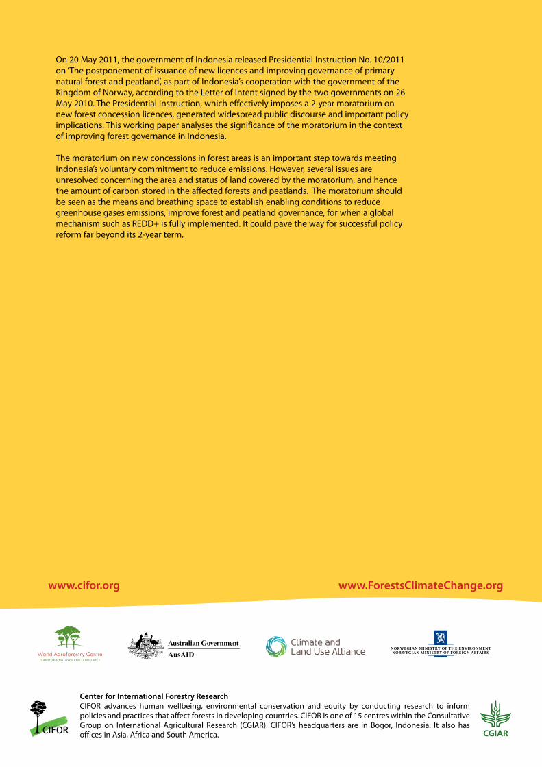
On 20 May 2011, the government of Indonesia released Presidential Instruction No. 10/2011 on ‘The postponement of issuance of new licences and improving governance of primary natural forest and peatland’, as part of Indonesia’s cooperation with the government of the Kingdom of Norway, according to the Letter of Intent signed by the two governments on 26 May 2010. The Presidential Instruction, which effectively imposes a 2-year moratorium on new forest concession licences, generated widespread public discourse and important policy implications. This working paper analyses the significance of the moratorium in the context of improving forest governance in Indonesia.
The moratorium on new concessions in forest areas is an important step towards meeting Indonesia’s voluntary commitment to reduce emissions. However, several issues are unresolved concerning the area and status of land covered by the moratorium, and hence the amount of carbon stored in the affected forests and peatlands. The moratorium should be seen as the means and breathing space to establish enabling conditions to reduce greenhouse gases emissions, improve forest and peatland governance, for when a global mechanism such as REDD+ is fully implemented. It could pave the way for successful policy reform far beyond its 2-year term.