Embed Size (px)
Citation preview
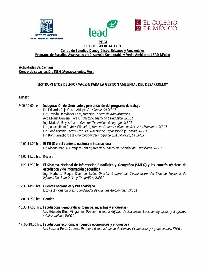
INEGI EL COLEGIO DE MEXICO
Centro de Estudios Demográficos, Urbanos y Ambientales Programa de Estudios Avanzados en Desarrollo Sustentable y Medio Ambiente, LEAD-México
Actividades 3a. Semana Centro de capacitación, INEGI Aguascalientes, Ags. "INSTRUMENTOS DE INFORMACION PARA LA GESTION AMBIENTAL DEL DESARROLLO" Lunes: 9:00-10:00 hrs. Inauguración del Seminario y presentación del programa de trabajo Dr. Eduardo Sojo Garza Aldape, Presidente del INEGI. Lic. Froylán Hernández Lara, Director General de Administración. Act. Miguel Cervera Flores, Director General de Estadística, INEGI. Ing. Mario A. Reyes Ibarra, Director General de Geografía, INEGI. Lic. Josué Hiram Suárez Villaseñor, Director General Adjunto de Recursos Humanos, INEGI. Lic. José Antonio Torres Vázquez, Director de Capacitación y Calidad, INEGI. Dr. Boris Graizbord Ed, Coordinador del Programa LEAD-México, COLMEX. 10:00-11:00 hrs. El INEGI en el contexto nacional e internacional Dr. Alberto Manuel Ortega y Venzor, Director General de Vinculación Estratégica, INEGI.
11:00-11:20 hrs. Receso
11:20-12:30 hrs. El Sistema Nacional de Información Estadística y Geográfica (SNIEG) y los comités técnicos de
estadística y de información geográfica Ing. Norberto Roque Díaz de León, Director General de Coordinación del Sistema Nacional de
Información Estadística y Geográfica, INEGI
12:30-14:00 hrs. Cuentas nacionales y PIB ecológico Lic. Raúl Figueroa Díaz, Coordinador de Cuentas Ambientales, INEGI 14:00-15:30 hrs. Comida 15:30-17:00 hrs. Estadísticas demográficas (censos, muestras y encuestas) Act. Edurado Ríos Mingramm, Director General Adjunto de Encuestas Sociodemográficas, y Registros
Administrativos, INEGI. 17: 00-18:00 hrs. Estadísticas económicas (censos económicos y encuestas) Act. Susana Pérez Cadena, Directora General Adjunta de Censos Económicos y Agropecuarios, INEGI.
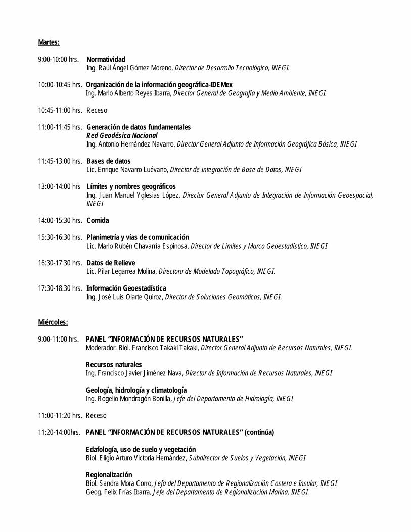
Martes: 9:00-10:00 hrs. Normatividad Ing. Raúl Ángel Gómez Moreno, Director de Desarrollo Tecnológico, INEGI. 10:00-10:45 hrs. Organización de la información geográfica-IDEMex Ing. Mario Alberto Reyes Ibarra, Director General de Geografía y Medio Ambiente, INEGI.
10:45-11:00 hrs. Receso 11:00-11:45 hrs. Generación de datos fundamentales Red Geodésica Nacional Ing. Antonio Hernández Navarro, Director General Adjunto de Información Geográfica Básica, INEGI
11:45-13:00 hrs. Bases de datos Lic. Enrique Navarro Luévano, Director de Integración de Base de Datos, INEGI
13:00-14:00 hrs Límites y nombres geográficos Ing. Juan Manuel Yglesias López, Director General Adjunto de Integración de Información Geoespacial,
INEGI 14:00-15:30 hrs. Comida 15:30-16:30 hrs. Planimetría y vías de comunicación Lic. Mario Rubén Chavarría Espinosa, Director de Límites y Marco Geoestadístico, INEGI 16:30-17:30 hrs. Datos de Relieve Lic. Pilar Legarrea Molina, Directora de Modelado Topográfico, INEGI. 17:30-18:30 hrs. Información Geoestadística Ing. José Luis Olarte Quiroz, Director de Soluciones Geomáticas, INEGI. Miércoles: 9:00-11:00 hrs. PANEL “INFORMACIÓN DE RECURSOS NATURALES” Moderador: Biol. Francisco Takaki Takaki, Director General Adjunto de Recursos Naturales, INEGI. Recursos naturales Ing. Francisco Javier Jiménez Nava, Director de Información de Recursos Naturales, INEGI Geología, hidrología y climatología Ing. Rogelio Mondragón Bonilla, Jefe del Departamento de Hidrología, INEGI 11:00-11:20 hrs. Receso 11:20-14:00hrs. PANEL “INFORMACIÓN DE RECURSOS NATURALES” (continúa) Edafología, uso de suelo y vegetación Biol. Eligio Arturo Victoria Hernández, Subdirector de Suelos y Vegetación, INEGI Regionalización Biol. Sandra Mora Corro, Jefa del Departamento de Regionalización Costera e Insular, INEGI Geog. Felix Frías Ibarra, Jefe del Departamento de Regionalización Marina, INEGI.
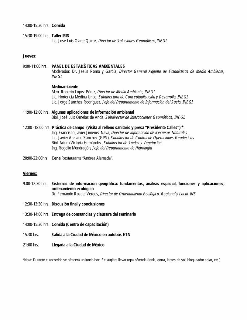
14:00-15:30 hrs. Comida 15:30-19:00 hrs. Taller IRIS Lic. José Luis Olarte Quiroz, Director de Soluciones Geomáticas,INEGI. Jueves: 9:00-11:00 hrs. PANEL DE ESTADÍSTICAS AMBIENTALES Moderador: Dr. Jesús Romo y García, Director General Adjunto de Estadísticas de Medio Ambiente,
INEGI. Medioambiente Mtro. Roberto López Pérez, Director de Medio Ambiente, INEGI Lic. Hortencia Medina Uribe, Subdirectora de Conceptualización y Desarrollo, INEGI. Lic. Jorge Sánchez Rodríguez, Jefe del Departamento de Información del Suelo, INEGI. 11:00-12:00 hrs. Algunas aplicaciones de información ambiental Biol. José Luis Ornelas de Anda, Subdirector de Interacciones Geomáticas, INEGI. 12:00 -18:00 hrs. Práctica de campo (Visita al relleno sanitario y presa “Presidente Calles”) * Ing. Francisco Javier Jiménez Nava, Director de Información de Recursos Naturales Lic. Javier Arellano Sánchez (GPS), Subdirector de Control de Operaciones Geodésicas Biól. Arturo Victoria Hernández, Subdirector de Suelos y Vegetación Ing. Rogelio Mondragón, Jefe del Departamento de Hidrología 20:00-22:00hrs. Cena Restaurante “Andrea Alameda”. Viernes: 9:00-12:30 hrs. Sistemas de información geográfica: fundamentos, análisis espacial, funciones y aplicaciones,
ordenamiento ecológico Dr. Fernando Rosete Verges, Director de Ordenamiento Ecológico, Regional y Local, INE 12:30-13:30 hrs. Discusión final y conclusiones 13:30-14:00 hrs. Entrega de constancias y clausura del seminario 14:00-15:30 hrs. Comida (Centro de capacitación) 15:30 hrs. Salida a la Ciudad de México en autobús ETN 21:00 hrs. Llegada a la Ciudad de México *Nota: Durante el recorrido se ofrecerá un lunch-box. Se sugiere llevar ropa cómoda (tenis, gorra, lentes de sol, bloqueador solar, etc.)
EL COLEGIO DE MEXICO, A. C. Centro de Estudios Demográficos, Urbanos y Ambientales
PROGRAMA DE ESTUDIOS AVANZADOS EN
DESARROLLO SUSTENTABLE Y MEDIO AMBIENTE LEAD-México
Bibliografía Tercera Semana
I n s p i r i n g l e a d e r s h i p f o r a s u s t a i n a b l e w o r l d 1
I N S T R U M E N T O S D E I N F O R M A C I Ó N P A R A L A G E S T I Ó N A M B I E N T A L D E L D E S A R R O L L O
Bibliografía básica Beveridge, Carrie, Gary Kocurek, Ryan C. Ewing, Nicholas Lancaster, P. Morthekai, Ashok K.
Singhvi and Shannon A. Mahan, 2006, “Development of Spatially Diverse and Complex Dune-Field Patterns: Gran Desierto Dune Field, Sonora, Mexico”, Sedimentology, 53, pp. 1391-1409, http://www.blackwell-synergy.com/doi/ref/10.1111/j.1365-3091.2006.00814.x?prevSearch=fulltextfield%3A%28climate+change+gis%29+and+%28allfield%3A%28mexico%29%29
Bhattarai, Rabin and Dushmata Dutta (2007) “Estimation of Soil Erosion and Sediment Yield Using
GIS at Catchment Scale”, Water Resour Manage 21, pp.1635–1647, http://www.springerlink.com/content/d5q7378114216u5p/fulltext.pdf
Bocco Verdinelli, Gerardo and Víctor M. Toledo, 1997, “Integrating Peasant Knowledge and
Geographic Information Systems: A Spatial Approach to Sustainable Agriculture”, in Indigenous Knowledge and Development Monitor, Vol. 5, Issue 2, August 1997, pp. 1013. (en formato digital).
Bocco Verdinelli, Gerardo y Mario Arturo Ortíz, 1994, “Definición de unidades espaciales para el
ordenamiento ecológico”, en Jaina, 5(1), pp. 8-9. (en formato digital). Bocco Verdinelli, Gerardo, Ángel Prieto y Helena Cloter, 2005, “La geografía física y el ordenamiento
ecológico del territorio: experiencias en México”, Gaceta Ecológica, julio-septiembre, No. 76, pp. 23-34, http://redalyc.uaemex.mx/redalyc/pdf/539/53907604.pdf
Bocco Verdinelli, Gerardo, José L. Palacio P. Y Carlos R. Valenzuela, 1991, “Integración de la
percepción remota y los sistemas de información geográfica”, en Ciencia y Desarrollo, Vol. XVII, No. 97, pp. 79-88. (en formato digital).
Bocco, G., M. Mendoza, A. Velázquez (2001) “Remote sensing and GIS-based regional
geomorphological mapping—a tool for land use planning in developing countries” Geomorphology 39, pp.211–219, (en formato digital).
Bocco, Gerardo, Manuel E. Mendoza, Ángel Priego y Ana Burgos (S/F) La cartografía de sistemas
naturales como base geográfica para la planificación territorial: una revisión de la bibliografía, (Artículo aceptado en la Revista Gaceta Ecológica, Nueva Época. Algunas partes del presente trabajo han sido modificadas de: M. Mendoza y G. Bocco. 1998. Instituto de Geografía, Univ. Nal. Autón. México. Serie Varia [17]: 25 – 55), 33 p, (en formato digital).
Bocco, Gerardo, Manuel Mendoza y Ornar R. Masera (2001) “La dinámica del cambio del uso del
suelo en Michoacán. Una propuesta metodológica para el estudio de los procesos de deforestación”, Investigaciones Geográficas, Boletín del Instituto de Geografía, Núm. 44., pp. 18-38, http://www.igeograf.unam.mx/instituto/publicaciones/boletin/bol44/b44art2.pdf
Bojórquez-Tapia, Luis A., Salomón Díaz-Mondragón and Exequiel Ezcurra, 2001, "GIS-based
Approach for Participatory Decision Making and Land Suitability Assessment”, International Journal of Geographical Information Science, Vol. 15, No. 2, pp. 129-151, (en formato digital).
EL COLEGIO DE MEXICO, A. C. Centro de Estudios Demográficos, Urbanos y Ambientales
PROGRAMA DE ESTUDIOS AVANZADOS EN
DESARROLLO SUSTENTABLE Y MEDIO AMBIENTE LEAD-México
Bibliografía Tercera Semana
I n s p i r i n g l e a d e r s h i p f o r a s u s t a i n a b l e w o r l d 2
Bosque Sendra, Joaquín y Rosa C. García, 2000, El uso de los sistemas de información geográfica en la planificación territorial, Anales de Geografía de la Universidad Complutense, 20, pp. 49-67, http://www.ucm.es/BUCM/revistas/ghi/02119803/articulos/AGUC0000110049A.PDF
Brown, Daniel G., Rick Riolo, Derek T. Robinson, Michael North and William Rand, 2005, “Spatial
Process and Data Models: Toward Integration of Agent-Based Models and GIS”, Journal Geographical Systems, 7, pp. 25-47, http://www.cscs.umich.edu/CSCS/research/projects/sluce/publications/Brown_et_al_2005.pdf
Buenrostro, Otoniel, Manuel Mendoza, Erna López Granados y Davide Geneletti (2008) "Analysis of
land suitability for the siting of inter-municipal landfills in the Cuitzeo Lake Basin, Mexico”, Waste Management 28, pp. 1137–1146, http://www.ciga.unam.mx/investigadores/zacatuche/PDF/611Articulos%20de%20investigacion%20en%20revistas%20arbitradas/6114Revistas%20Internacionales%20(indexadas%20en%20el%20science%20citation%20index)/6114-14.pdf
Cayuela, Luis, José María Rey Benayas, Ana Justel and Javier Salas-Rey, 2006, "Modelling Tree
Diversity in a Highly Fragmented Tropical Montane Landscape”, Global Ecology and Biogeography, Vol. 15, Issue 6, pp. 602–613, http://www.blackwell-synergy.com/doi/suppl/10.1111/j.1466-8238.2006.00255.x
Chakhar, Salem, 2003, “Enhancing Geographical Information Systems Capabilities with Multi-
Criteria Evaluation Functions”, Journal of Geographic Information and Decision Analysis, Vol. 7, No. 2, pp. 47 – 71, http://www.geodec.org/Chakhar.pdf
Chowdhury, Rinku Roy, 2006, “Driving Forces of Tropical Deforestation: The Role of Remote
Sensing and Spatial Models”, Singapore Journal of Tropical Geography, Vol. 27, Issue 1, March, pp. 82–101, http://www.blackwell-synergy.com/doi/ref/10.1111/j.1467-9493.2006.00241.x?prevSearch=fulltextfield%3A%28climate+change+gis%29+and+%28allfield%3A%28mexico%29%29
Elwood, Sarah, 2006, "Deconstructions, Reconstructions, and New Research Directions”,
Transactions in GIS, 10(5), pp. 693–708, http://www.blackwell-synergy.com/doi/pdf/10.1111/j.1467-9671.2006.01023.x-
Fernandes, J. P., N. Guiomar and A. P. Soares, 2006, "Geometries in Landscape Ecology”, Journal of Mediterranean Ecology, Vol. 7, No.1-2-3-4, pp. 3-13, http://www.jmecology.com/%5Cpdf%5C2006%5CFernandes3-13.pdf
Flores R., Ernesto J. y Alexander Parra U. (1997) “Los Sistemas de Información Geográfica en la
clasificación: evaluación de tierras”, Geoenseñanza 2-(1), pp. 129-141, (en formato digital). Geomorphology Editorial (2008) "GIS technology and models for assessing landslide hazard and
risk”, Geomorphology 94, pp. 257–260, (en format digital). Gold, Christopher M., 2006, “What is GIS and What is Not?”, Transactions in GIS, 10(4) pp. 505–
519, http://www.blackwell-synergy.com/doi/pdf/10.1111/j.1467-9671.2006.01009.x Goodchild, M. F., 2006, "GIScience Ten Years after Ground Truth”, Transactions in GIS, 10(5), pp.
687–692, http://www.blackwell-synergy.com
EL COLEGIO DE MEXICO, A. C. Centro de Estudios Demográficos, Urbanos y Ambientales
PROGRAMA DE ESTUDIOS AVANZADOS EN
DESARROLLO SUSTENTABLE Y MEDIO AMBIENTE LEAD-México
Bibliografía Tercera Semana
I n s p i r i n g l e a d e r s h i p f o r a s u s t a i n a b l e w o r l d 3
Goodchild, Michael F. and Robert P. Haining, 2004, “GIS and Spatial Data Analysis: Converging Perspectives”, Papers in regional Science, 83, pp. 363–385, http://www.blackwell-synergy.com/action/doi/pdf/10.1007/s10110-003-0190-y-
Harris Richard, Peter Hopkinson, Sarah McCaffrey and Lynn Huntsinger, 1997, “Comparison of a
Geographical Information System versus Manual Techniques for Land Cover Analysis in a Riparian Restoration Project”, in Journal Soil and Water Conservation, March-April 1997, pp. 112-117. (en formato digital).
Hea, Chansheng, Stephen B. Malcolmb, Kenneth A. Dahlbergc and Bojie Fud (2000) “A conceptual
framework for integrating hydrological and biological indicators into watershed management”, Landscape and Urban Planning 49, 25-34, (en format digital).
Ismail Jasmin and S. Ravichandran (2008) “RUSLE2 Model Application for Soil Erosion Assessment
Using Remote Sensing and GIS”, Water Resour Manage 22, pp.83-102, http://www.springerlink.com/content/uk3208r2718616n1/fulltext.pdf
Jankowski, Piotr and Timothy Nyerges, 2001, “GIS-Supported Collaborative Decision Making:
Results of a Experiment”, Annals of the Association of American Geographers, Vol. 91, No. 1, March, pp. 48-70, http://www.blackwell-synergy.com/links/doi/10.1111/0004-5608.00233/abs/
Jiang, Bin and Xiaobai Yao, 2006, “Location-Based Services and GIS in Perspective”, Computers,
Environment and Urban Systems, 30, pp. 712–725, http://www.hig.se/~bjg/LBS.pdf Johnson, Richard K., Mike T. Furse, Daniel Hering and Leonard Sandin, 2007, “Ecological
Relationships between Stream Communities and Spatial Scale: Implications for Designing Catchmentlevel Monitoring Programmes”, Freshwater Biology, pp. 1-20, http://www.blackwell-synergy.com
Kwan, Mei-Po, 2004, “GIS Methods in Time-Geographic Research: Geocomputation and
Geovisualization of Human Activity Patterns”, Geografiska Annaler, 86 B, 4, pp. 267-280, http://www.blackwell-synergy.com/doi/pdf/10.1111/j.0435-3684.2004.00167.x-
Lambin, Eric F., 1997, “Modelling and Monitoring Land-cover Change Processes in Tropical
Regions”, in Progress in Physical Geography, 21, 3 (1997), pp. 375-393. (en formato digital). Lambin, Eric F., 1999, “Monitoring Forest Degradation in Tropical Regions by Remote Sensing:
Some Methodological Issues”, Global Ecology and Biogeography, 8, pp. 191–198, http://www.blackwell-synergy.com/links/doi/10.1046/j.1365-2699.1999.00123.x
Lambin, Eric F., Helmut J. Geist, and Erika Lepers, 2003, “Dynamics of Land-Use and Land-Cover
Change in Tropical Regions”, Annual Review of Environment and Resources, 28, pp. 205-241, http://www.usf.uni-kassel.de/ftp/lehre/priess/Lambin-et-al-2003_dynamics-of-LUCC-in-tropical-regions.pdf
Liu, Suxia and Xuan Zhu, 2004, “An Integrated GIS Approach to Accessibility Analysis”,
Transactions in GIS, 8 (1), pp. 45-62, http://www.blackwell-synergy.com/doi/pdf/10.1111/j.1467-9671.2004.00167.x-
López Granados, Erna Martha, Gerardo Bocco y Manuel Eduardo Mendoza Cantú, 2001, “Predicción
del cambio de cobertura y uso del suelo: el caso de la ciudad de Morelia”, Boletín del Instituto
EL COLEGIO DE MEXICO, A. C. Centro de Estudios Demográficos, Urbanos y Ambientales
PROGRAMA DE ESTUDIOS AVANZADOS EN
DESARROLLO SUSTENTABLE Y MEDIO AMBIENTE LEAD-México
Bibliografía Tercera Semana
I n s p i r i n g l e a d e r s h i p f o r a s u s t a i n a b l e w o r l d 4
de Geografía UNAM, No. 45, pp 56-76, http://www.igeograf.unam.mx/instituto/publicaciones/boletin/bol45/b45art4.pdf
López, Erna, Gerardo Bocco, Manuel Mendoza and Emilio Duhaub (2001) "Predicting land-cover and
land-use change in the urban fringe A case in Morelia city, Mexico”, Landscape and Urban Planning 55, pp. 271-285, (en format digital).
Luna, Laura y Luis Chias (1999) “El uso de SIG en el análisis de la distribución de accidentes en
carreteras: el caso de Tamaulipas, México”, Investigaciones Geográficas, Boletín 40, pp. 148-162, http://www.igeograf.unam.mx/instituto/publicaciones/boletin/bol40/b40art10.pdf
Malczewski, Jacek (2004) “GIS-based land-use suitability analysis: a critical overview”, Progress in
Planning 62, pp. 3-65, http://eref.uqu.edu.sa/files/eref2/folder2/gis_based_land_use_suitability_analysis__72288.pdf
Mendoza, Manuel, G. Bocco, M. Bravo, Erna López and W. R. Osterkamp (2006) "Predicting Water-
Surface Fluctuation of Continental Lakes: A RS and GIS Based Approach in Central Mexico”, Water Resources Management 20, pp. 291–311, http://www.springerlink.com/content/t13473722l37m683/fulltext.pdf
México, Secretaría de Medio Ambiente y Recursos Naturales, Instituto Nacional de Ecología (2006)
Manual del Proceso de Ordenamiento Ecológico, México, SEMARNAT, 335 p, http://www.semarnat.gob.mx/queessemarnat/politica_ambiental/ordenamientoecologico/Documents/documentos%20ordenamiento/manual_poe.pdf
Morril, Richard and Jacqueline Dormitzer, 1979, The Spatial Order: An Introduction to Modern
Geography, USA, Duxbury Press, pp. 31-65. (en formato digital). Palacio-Prieto, J.L. et. al (2004) Indicadores para la caracterización y el ordenamiento territorial,
México, SEDESOL, SEMARNAT, INE, UNAM, 161 p, (en formato digital). Pebesma, Edzer J., 2006, "The Role of External Variables and GIS Databases in Geostatistical
Analysis”, Transactions in GIS, 10(4), pp. 615–632, http://www.blackwell-synergy.com/doi/pdf/10.1111/j.1467-9671.2006.01015.x
Schuschny, Andrés Ricardo y Gilberto Carlos Gallopín, 2004, La distribución espacial de la pobreza
en relación a los sistemas ambientales en América Latina, (Serie medio Ambiente y Desarrollo 87), Santiago de Chile, Naciones Unidas, 43 p., http://www.eclac.org/publicaciones/MedioAmbiente/7/LCL2157P/SERIE87.pdf
Sener, Basak, M. Lütfi Süzen and Vedat Doyuran (2006) “Landfill site selection by using geographic
information systems”, Environ Geol 49, pp. 376-388, http://www.springerlink.com/content/y921772rj7067187/fulltext.pdf
Sharifi, Ali, Marjan van Herwijnen and Willem van den Toorn (2004) Spatial Decision Support
Systems, (S/L), Lecture Notes, 234 p, (en format digital). Sharifi,M., W.Vandentoorn, A. Ricoand and M. Emmanuel (2002) “Application of GIS and
Multicriteria Evaluation in Locating Sustainable Boundary between theTunari National Park and Cochabamba City (Bolivia)”, Journal of Multi-Criteria Decision Analysis 11, pp. 151–164, (en format digital).
EL COLEGIO DE MEXICO, A. C. Centro de Estudios Demográficos, Urbanos y Ambientales
PROGRAMA DE ESTUDIOS AVANZADOS EN
DESARROLLO SUSTENTABLE Y MEDIO AMBIENTE LEAD-México
Bibliografía Tercera Semana
I n s p i r i n g l e a d e r s h i p f o r a s u s t a i n a b l e w o r l d 5
Sheng, Ted C., Robert E. Barrett and Thomas R. Mitchell, 1997, “Using Geographic Information Systems for Watershed Classification and Rating in Developing Countries”, in Journal of Soil and Water Conservation, March-April 1997, pp. 84-89. (en formato digital).
Uran, Oddrun, Piet Rietveld, Ron Janssen and Henk J. Scholten, 2003, “Spatial Decision Support
Systems: A user’s perspective”, Journal of Geographic Information and Decision Analysis, Vol. 7, No. 1, pp. 47 – 63, http://www.geodec.org/Uran.pdf
Van Herwijnen, Marjan (1999) Spatial Decision Support for Environmental Management, (S/L),
Elinkwijk bv, 275 p, (en format digital). Weiner, Daniel, Trevor M. Harris and William J. Craig, Community Participation and Geographic
Information Systems, 18 p., http://www.spatial.maine.edu/~onsrud/Spoleto/WeinerEtAl.pdf Wilson, John P., Helena Mitasova and Dawn J. Wright, 2000, “Water Resource Applications of
Geographic Information Systems”, URISA Journal, Vol. 12, No. 2, Spring, pp. 61-79, http://citeseer.ist.psu.edu/cache/papers/cs/23079/http:zSzzSzwww.urisa.orgzSzJournalzSzprotectzSzVol12No2zSzwilsonzSzwilson.pdf/wilson00water.pdf
Bibliografía Complementaria Batty, Michael, 1992, "The Fractal Nature of Geography", Geographical Magazine, May 1992, pp.
32-36. (en formato digital). Fisher, P.F. and Richard E. Lindenberg, 1990, "On Distinctions among Cartography, Remote Sensing,
and Geographic Information Systems", Photogrammetric Engineering and Remote Sensing, Vol. 55, No.103, October 1989, pp.1431-1434. (en formato digital).
Fisher, P.F., 1991, "Spatial Data Sources and Data Problems", in: Maguire, David J., Michael F.
Goodchid, and David W. Rhind (eds.), Geographical Information Systems. Principles and Applications. Volume I: Principles, Longman Scientific & Technical, copublished in the United States and Canada with John Wiley & Sons, Inc, New York, N.Y., pp. 175-189. (en formato digital).
Goodchild, Michael F., 1992, "Geographical Data Modeling", Computers & Geosciences, Vol. 18, No.
4, 1992 Pergamon Press Ltd., Great Britain, pp. 401-408. (en formato digital). Hannah, Lee, David Lohse, Charles Hutchinson, John Carr and Ali Lankerani, 1994, "A Preliminary
Inventory of Human Disturbance of World Ecosystems", AMBIO, Volume XXIII, Number 4-5, July 1994, The Royal Swedish Academy of Sciences, pp. 246-250. (en formato digital).
Healey, R.G., 1991, "Database Management Systems", in: Maguire, David J., Michael F. Goodchid,
and David W. Rhind (eds.), Geographical Information Systems. Principles and Applications. Volume I: Principles, Longman Scientific & Technical, copublished in the United States and Canada with John Wiley & Sons, Inc, New York, N.Y., pp. 251-267. (en formato digital).
Maguire, D.J., 1991, "An Overview and Definition of GIS", in: Maguire, David J., Michael F.
Goodchid, and David W. Rhind (eds.), Geographical Information Systems. Principles and Applications. Volume I: Principles, Longman Scientific & Technical, copublished in the United States and Canada with John Wiley & Sons, Inc, New York, N.Y., pp. 9-20. (en formato digital).
EL COLEGIO DE MEXICO, A. C. Centro de Estudios Demográficos, Urbanos y Ambientales
PROGRAMA DE ESTUDIOS AVANZADOS EN
DESARROLLO SUSTENTABLE Y MEDIO AMBIENTE LEAD-México
Bibliografía Tercera Semana
I n s p i r i n g l e a d e r s h i p f o r a s u s t a i n a b l e w o r l d 6
Martin, David, 1991, Geographic Information Systems and their Socioeconomic Applications,
Routledge, pp. 1-43, 161-166. (en formato digital). Ottens, Henk F.L., 1990, "The Application of Geographical Information Systems in Urban and
Regional Planning", in: Scholten, Henk J. and John C.H. Stillwell, (eds.), 1990, Geographical Information Systems for Urban and Regional Planning, Kluwer Academic Publishers, pp. 15-21. (en formato digital).
Bibliografía Complementaria digital Agarwal, P., 2005, “Ontological Considerations in GIScience”, International Journal of Geographical
Information Science, Vol. 19, No. 5, May 2005, pp. 501–536, http://taylorandfrancis.metapress.com/media/GPGPXNXXYKNA9ALWUP4U/Contributions/K/6/K/1/K6K186581U78726Q.pdf
Albertz, Jörg and Albert Wiedemann, Topographic and Thematic Mapping from Satellite Image Data,
10 p., http://www.al-wie.de/lit/IstMap.pdf Alföldi, T. T., 1996, Introduction to Digital Images and Digital Analysis Techniques: A Basic Course
for the Appreciation of Digital Analysis of Remotely Sensed Multispectral Data, (Technical Note 78-1), Ottawa, Canada Centre for Remote Sensing, Natural Resources Canada, 14 p., http://www.ccrs.nrcan.gc.ca/ccrs/learn/tutorials/digitech/intro_e.pdf
Arpinar, I. Budak, Amit Sheth, , Cartic Ramakrishnan, E. Lynn Usery, Molly Azami and Mei-Po
Kwan, 2004, “Geospatial Ontology Development and Semantic Analytics”, in Eds: Wilson, J. P. and A. S. Fotheringham (eds.), Handbook of Geographic Information Science, Blackwell Publishing, 21 p., http://www.ncgia.ucsb.edu/projects/nga/docs/ontology.pdf
Aubry Philippe and Domitien Debouzie, 2000, “Geostatistical Estimation Variance for the Spatial
Mean in Two-Dimensional Systematic Sampling”, Ecology, Vol. 81, No. 2, pp. 543-553, http://www.jstor.org/cgi-bin/jstor/printpage/00129658/ap010018/01a00210/0.pdf?backcontext=table-of-contents&dowhat=Acrobat&config=jstor&[email protected]/01cce440370050181dd5f&0.pdf
Baker, John C., Beth E. Lachman, David R. Frelinger, Kevin M. O’connell, Alexander C. Hou,
Michael S., Tseng, David Orletsky and Charles Yost, 2004, Mapping the Risks: Assessing the Homeland Security Implications of Publicly Available Geospatial Information, (Prepared for the National Geospatial-Intelligence Agency), USA, National Defense Research Institute, 237 p., http://www.rand.org/pubs/monographs/2004/RAND_MG142.pdf
Balley, Sandrine, Christine Parent and Stefano Spaccapietra, 2004, “Modelling Geographic Data with
Multiple Representations”, International Journal of Geographical Information Science, Vol. 18, No. 4, June 2004, pp. 327–352, http://taylorandfrancis.metapress.com/media/3AGPXGYRTNF5AC159DCG/Contributions/J/9/C/N/J9CN20ERX3LJD7BT.pdf
Bill, Ralf and Görres Grenzdörffer, 1993, “The Importance of digital Ortophotos for Sectoral Geo-
Information Systems”, in Fritsch, D. and D. Hobbie, (eds), Photogrammetric Week’93,
EL COLEGIO DE MEXICO, A. C. Centro de Estudios Demográficos, Urbanos y Ambientales
PROGRAMA DE ESTUDIOS AVANZADOS EN
DESARROLLO SUSTENTABLE Y MEDIO AMBIENTE LEAD-México
Bibliografía Tercera Semana
I n s p i r i n g l e a d e r s h i p f o r a s u s t a i n a b l e w o r l d 7
Wichmann, Karlsruhe, pp. 285-299, http://www.ifp.uni-stuttgart.de/publications/phowo93/Bill.pdf
Bowker, Geoffrey C., 2000, “Mapping biodiversity”, Int. J. Geographical Information Science, 2000,
vol. 14, no. 8, pp. 739-754, http://taylorandfrancis.metapress.com/media/EFGLTHQXWHA2AERGXLDV/Contributions/L/W/B/F/LWBFU5EFQE11GJ2P.pdf
Buttenfield, Barbara P., 2000, “Mapping Ecological Uncertainty”, in Hunsaker, C.T., Goodchild,
M.F., Friedl, M. A., and Case. T. J. (eds.), Spatial Uncertainty in Ecology, New York, Springer-Verlag, pp. 116- 132, http://www.colorado.edu/geography/babs/geog_5113_s04/bibliography/NCEAS%20reprint.pdf
Cairns, Michael A., Patricia K. Haggerty, Roman Alvarez, Ben H. J. De Jong and Ingrid Olmsted,
2000, “Tropical Mexico's Recent Land-Use Change: A Region's Contribution to the Global Carbon Cycle”, Ecological Applications, Vo. 10, No. 5, pp. 1426-1441, http://www.jstor.org/cgi-bin/jstor/printpage/10510761/di014629/01p0380d/0.pdf?backcontext=table-of-contents&dowhat=Acrobat&config=jstor&[email protected]/01cce440370050181dd5f&0.pdf
Chrisman, Nicholas, Readings in GIS and Public and Nonprofit Administration: Implementing a GIS,
(SOURCE: Nicholas Crisman, 1997, Exploring Geographic Information Systems, pp. 241-252), 10 p., http://images.main.uab.edu/psychology/gps/MPA674b.PDF
Chrysoulakis, N., M. Diamandakis and P. Prastacos, 2003, GIS Integration of Aster Stereo Imagery for
the support of Watershed Management, (8th International Conference on Environmental Science and Technology, Lemnos island, Greece, 8-10 September 2003), 8 p., http://www.iacm.forth.gr/regional/papers/111_118.pdf
Cohen, Marianne and Catherine Mering, 2004, Geographic Information System and spatial Effect
Applied to the study of the relationship between dynamics of ligneous cover and sheep breeders’ practices, CYBERGEO : European Journal of Geography, N.272, 25 June 2004, (12th international colloquium of theoretical and quantitative geography – Saint-Valery-en-Caux – 2001 sept.), 17 p., (REFERENCIA BIBLIOGRÄFICA), http://www.cybergeo.presse.fr/ectqg12/cohen/272.pdf
Deng, Yu, 2002, The Metadata Architecture for Data Management in Web-based Choropleth Maps,
27 p., http://www.cs.umd.edu/projects/hcil/census/JavaProto/metadata.pdf Diggle, P. J., J. A. Tawn and R. A. Moyeed, 1998, “Model-Based Geostatistics”, Applied Statistics,
Vol. 47, No. 3, pp. 299-350, http://www.jstor.org/cgi-bin/jstor/printpage/00359254/di993406/99p0127a/0.pdf?backcontext=table-of-contents&dowhat=Acrobat&config=jstor&[email protected]/01cce440370050181dd5f&0.pdf
Dobson, Jerome E. and Richard C. Durfee, ONRL and the Geographic Information Systems
Revolution, 25 p., http://www.ornl.gov/info/ornlreview/rev28-1/text/gis.htm Eiumnoh, Apisit, Integration of Geographic Information Systems (GIS) and Satellite Remote Sensing
(SRS) for Watershed Management, 11 p., www.fftc.agnet.org/library/data/tb/tb150/tb150.pdf
EL COLEGIO DE MEXICO, A. C. Centro de Estudios Demográficos, Urbanos y Ambientales
PROGRAMA DE ESTUDIOS AVANZADOS EN
DESARROLLO SUSTENTABLE Y MEDIO AMBIENTE LEAD-México
Bibliografía Tercera Semana
I n s p i r i n g l e a d e r s h i p f o r a s u s t a i n a b l e w o r l d 8
Evans, Tom P. and Emilio F. Moran, 2002, “Spatial Integration of Social and Biophysical Factors Related to Landcover Change”, Population and Development Review, Vol. 28, Supplement Population and Environment: Methods and Analysis, pp. 165-186, http://www.jstor.org/cgi-bin/jstor/printpage/00987921/sp030008/03x0171o/0.pdf?backcontext=table-of-contents&dowhat=Acrobat&config=jstor&[email protected]/01cce440370050181dd5f&0.pdf
Fonseca, F. and Egenhofer, M., 1999, “Knowledge Sharing in Geographic Information Systems”. in:
P. Scheuermann (ed.), The Third IEEE International Knowledge and Data Engineering Exchange Workshop, Chicago IL, pp. 85-90, http://www.spatial.maine.edu/~fred/fonseca_kdex99.pdf
Fonseca, Frederico T. and Max J. Egenhofer, 1999, Ontology-Driven Geographic Information
Systems, (7th ACM Symposium on Advances in Geographic Information Systems, Kansas City, MO, C. Bauzer Medeiros [ed.], November 1999), 7 p., http://www.spatial.maine.edu/~fred/fonseca_acmgis.pdf
Geist, Helmut J., and Eric F. Lambin, 2002, Proximate Causes and Underlying Driving Forces of
Tropical Deforestation, BioScience, Vol. 52, No. 2, February 2002, pp. 143-150, http://www.geo.ucl.ac.be/LUCC/pdf/02_February_Article_Geist_.pdf
Geographic Information System, Remote Sensing, and Telemetry Working Group, Glossary of GIS
and Remote Sensing Terms, 7 p., http://fwie.fw.vt.edu/tws-gis/glossary.htm Habib, Ayman F. and Rami I. Alruzouq, 2004, “Line-Based Modified Iterated Hough Transform for
Automatic Registration of Multi-Source Imagery”, The Photogrammetric Record, Vol. 19, No. 105, March 2004, pp. 5–21, http://www.blackwell-synergy.com/toc/phor/19/105
Haklay, Mordechai (Muki), 2004, “Map Calculus in GIS: A Proposal and Demonstration”,
International Journal of Geographical Information Science, Vol. 18, No. 2, March 2004, pp. 107–125, http://taylorandfrancis.metapress.com/media/2724FR9EFG7TTL597AR6/Contributions/J/6/N/6/J6N6RK65FLPGAFKP.pdf
Harvard Design School, Vector GIS Procedures -- A Tutorial, 7 p., (REFERENCIA
BIBLIOGRÁFICA), http://www.gsd.harvard.edu/geo/manual/vector/index.htm Harvard Desing School, Fundamental Raster GIS Procedures, 14 p., (REFERENCIA
BIBLIOGRÁFICA), http://www.gsd.harvard.edu/geo/manual/raster/index.htm Harvey, Francis, 2000, "The social construction of geographical information systems”, Int. J.
Geographical Information Science, 2000, vol. 14, no. 8, pp. 711-713, http://taylorandfrancis.metapress.com/media/M3T1FMWWRM0JXT3H9J5M/Contributions/A/W/7/V/AW7VWEHQ3GQXWM8L.pdf
Harvey, Francis, 2003, "Developing geographic information infrastructures for local government: the
role of trust”, The Canadian Geographer, Vol. 47, No. 1, Spring 2003, pp. 28-36, http://vnweb.hwwilsonweb.com/hww/shared/shared_main.jhtml;jsessionid=ZSYVVTWYQG1KDQA3DIKSFGOADUNGIIV0?_requestid=32394
Harvey, Francis, Werner Kuhn, Hardy Pundt, Yaser Bishr and Catharina Riedemann, 1999, “Semantic
interoperability: A central issue for sharing geographic information”, The Annals Regional
EL COLEGIO DE MEXICO, A. C. Centro de Estudios Demográficos, Urbanos y Ambientales
PROGRAMA DE ESTUDIOS AVANZADOS EN
DESARROLLO SUSTENTABLE Y MEDIO AMBIENTE LEAD-México
Bibliografía Tercera Semana
I n s p i r i n g l e a d e r s h i p f o r a s u s t a i n a b l e w o r l d 9
Science, (1999) 33, pp. 213-232, http://www.metapress.com/media/6EA5D3WUVM1TVMLPGW97/Contributions/T/3/X/G/T3XGWDPM1VQBF4XT.pdf
Heipke, Christian, 2002, "Requirements for Modern Geographic Information Systems”, IAPRS, Vol.
XXXIV, Part 2, Commission II, Xi’an, Aug.20-23, 2002, pp. 173-184, http://www.isprs.org/commission2/keynotes/comm2_keynote2_heipke.pdf
International Steering Committee for Global Mapping, 2000, Global Map, Version 1.1 Specifications,
(adopted at 7th ISCGM meeting Cape Town 16 March 2000), ISCGM, 33 p., http://www.iscgm.org/cgi-bin/fswiki/wiki.cgi?action=ATTACH&page=Documentation&file=gmspec%2D1%2E1%2Epdf
Karl, J. W., P. J. Heglund, E. O. Garton, J. M. Scott, N. M. Wright and R. L. Hutto, 2000, “Sensitivity
of Species Habitat-Relationship Model Performance to Factors of Scale”, Ecological Applications, Vol. 10, No. 6, pp. 1690-1705, http://www.jstor.org/cgi-bin/jstor/printpage/10510761/di014630/01p0012j/0.pdf?backcontext=table-of-contents&dowhat=Acrobat&config=jstor&[email protected]/01cce440370050181dd5f&0.pdf
Karssenberg, D. and K. De Jong, 2005, “Dynamic Environmental Modelling In GIS: 2. Modelling
Error Propagation”, International Journal of Geographical Information Science, Vol. 19, No. 6, July 2005, pp. 623–637, http://taylorandfrancis.metapress.com/media/159RJMXRXK5TWQGUNM13/Contributions/M/7/0/2/M702863291583V16.pdf
Karssenberg, D. and K. De Jong, 2005, “Dynamic Environmental Modelling in GIS: 1. Modelling in
Three Spatial Dimensions”, International Journal of Geographical Information Science, Vol. 19, No. 5, May 2005, pp. 559–579, http://taylorandfrancis.metapress.com/media/3846YNVUXQ0TAERGXLDV/Contributions/W/1/8/0/W180105KM72L11L3.pdf
Knox, J.W. and E.K. Weatherfield, 1999, The Application of GIS to Irrigation Water Resource
Management in England and Wales, The Geographical Journal, Vol. 165, No. 1, March 1999, pp. 90-98, http://www.jstor.org/cgi-bin/jstor/printpage/00167398/sp020016/02x0710h/0.pdf?backcontext=table-of-contents&dowhat=Acrobat&config=jstor&[email protected]/01cc99334100501a28f78&0.pdf
Kuhn, Werner, 2003, “Semantic Reference Systems”, International Journal of Geographical
Information Science, Vol. 17, No. 5, July-August 2003 , pp. 405-409, http://taylorandfrancis.metapress.com/media/EFGPXGYHTNPC0QGUNM13/Contributions/W/5/F/P/W5FP1145U5RG6F42.pdf
Kumsap, C., F. Borne and D. Moss, 2005, “The Technique of Distance Decayed Visibility for Forest
Landscape Visualization”, International Journal of Geographical Information Science, Vol. 19, No. 6, July 2005, pp. 723–744, http://taylorandfrancis.metapress.com/media/M37LVLXUQHDE7A768X2M/Contributions/L/2/W/7/L2W7386R68383031.pdf
Leung, Y., Y. Lee, K. C. Lam, K. Lin and F. T. Zeng, 2005, 2An Environmental Decision-Support
System for the Management of Water Pollution in a Tidal River Network”, International
EL COLEGIO DE MEXICO, A. C. Centro de Estudios Demográficos, Urbanos y Ambientales
PROGRAMA DE ESTUDIOS AVANZADOS EN
DESARROLLO SUSTENTABLE Y MEDIO AMBIENTE LEAD-México
Bibliografía Tercera Semana
I n s p i r i n g l e a d e r s h i p f o r a s u s t a i n a b l e w o r l d 10
Journal of Geographical Information Science, Vol. 19, No. 4, April 2005, pp. 483–500, http://taylorandfrancis.metapress.com/media/MFTA255AWK5QWGAA9J4K/Contributions/Y/W/A/Y/YWAYKD647CGVV2JQ.pdf
Lilburne, L. R., T. H. Webb and G. L. Benwell, 2004, “The Scale Matcher: A Procedure for Assessing
Scale Compatibility of Spatial Data and Models”, International Journal of Geographical Information Science, Vol. 18, No. 3, April–May 2004, pp. 257–279, http://taylorandfrancis.metapress.com/media/3768YNVWXN4Q0YLXJAR6/Contributions/G/R/P/9/GRP93GH5GGGE4UK4.pdf
Llobera, M., 2003, "Extending GIS-based Visual Analysis: the Concept of Visualscapes”,
International Journal of Geographical Information Science, Vol. 17, No. 1, January 2003 , pp. 25-48, http://taylorandfrancis.metapress.com/media/GMUAAMXRQM2WV2RLFRAY/Contributions/N/K/5/C/NK5CVEFVAA4CA5KT.pdf
MacEachren, Alan M., Frank Hardisty, Mark Gahegan, Michael Wheeler, Xiping Dai, Diansheng Guo
and Masa Takatsuka, Supporting Visual Integration and Analysis of Geospatially-referenced Data through Web-deployable, Cross-platform Tools, 8 p., http://www.geovista.psu.edu/publications/Dgla01/DG01_AMM_PSU.pdf
Machín, Jorge Ángel Luis, 2004, “Estudio del relieve para la gestión ambiental, con el uso de Sistemas
de Información Geográficos (SIG)”, 12 p., http://www.elagrimensor.com.ar/elearning/lecturas/ESTUDIO%20DEL%20RELIEVE.pdf
Manson, Steven M., 2004, Boundedly Rational Land-use Strategies and the Local Dimensions of
Human Vulnerability and Resilience in the Yucatán Peninsula, (Manson–LASA 2004 – Boundedly rational land-use strategies), (Prepared for delivery at the 2004 Meeting of the Latin American Studies Association, Las Vegas, Nevada, October 7-9, 2004), 18 p., http://www.tc.umn.edu/~manson/Manson_2004_LASA_BR_in_SYPR.pdf
Mchaffie, Patrick, 2000, “Surfaces: Tacit knowledge, Formal Language, and Metaphor at the Harvard
Lab for Computer Graphics and Spatial Analysis”, Int. J. Geographical Information Science, 2000, vol. 14, no. 8, pp. 755- 773, http://taylorandfrancis.metapress.com/media/7HXDAF810G4XUH480RE7/Contributions/U/T/W/3/UTW3X0VUXX4URCXP.pdf
Mercer, J. Bryan, 1995, “SAR Technologies for Topographic Mapping”, in Fritsch D. and D. Hobbie,
(eds), Photogrammetric Week 95, Wichmann Verlag, Heidelberg, pp. 117-126, http://www.ifp.uni-stuttgart.de/publications/phowo95/Mercer.pdf
México, Dirección General de Investigación de Ordenamiento Ecológico y Conservación de los
Ecosistemas–Instituto Nacional de Ecología, Dirección General de Política Ambiental e Integración Regional y Sectorial-SEMARNAT y Dirección General de Desarrollo Territorial-SEDESOL, 2005, Términos de referencia para la elaboración del Programa Municipal de Ordenamiento Ecológico y Territorial (PMOET), México, SEMARNAT, SEDESOL, 24 p., http://reliot.ine.gob.mx/ter_ref_pmoet.pdf
México, H. Congreso de la Unión, 1983, Ley de información Estadística y Geográfica, (Nueva Ley
publicada en el Diario Oficial de la Federación el 30 de diciembre de 1980), (última reforma aplicada 12/12/1983), México, Congreso de la Unión, 15 p., http://www.cddhcu.gob.mx/leyinfo/pdf/41.pdf
EL COLEGIO DE MEXICO, A. C. Centro de Estudios Demográficos, Urbanos y Ambientales
PROGRAMA DE ESTUDIOS AVANZADOS EN
DESARROLLO SUSTENTABLE Y MEDIO AMBIENTE LEAD-México
Bibliografía Tercera Semana
I n s p i r i n g l e a d e r s h i p f o r a s u s t a i n a b l e w o r l d 11
México, Instituto Nacional de Estadística Geografía e Informática, 2001, Utilidad de los Censos
Económicos 1999, México, INEGI, 20 p., http://www.inegi.gob.mx/prod_serv/contenidos/espanol/bvinegi/productos/censos/economicos/1999/general/utilidad.pdf
México, Instituto Nacional de Estadística Geografía e Informática, 2005, Anuario estadístico de los
Estados Unidos Mexicanos, edición 2004, México, INEGI, 100 p., http://www.inegi.gob.mx/prod_serv/contenidos/espanol/bvinegi/productos/integracion/pais/aeeum/2004/Aeeum2004%20Archivo%201.pdf
México, Instituto Nacional de Estadística Geografía e Informática, 2005, Anuario de Estadísticas por
Entidad Federativa, edición 2005, México, INEGI, 295 p., http://www.inegi.gob.mx/prod_serv/contenidos/espanol/bvinegi/productos/integracion/pais/aepef/2005/AEPEF%2005%20%28Archivo%201%29.pdf
México, Instituto Nacional de Estadística Geografía e Informática, 2004, Agenda Estadística de los
Estados Unidos Mexicanos, edición 2004, México, INEGI, 243 p., http://www.inegi.gob.mx/prod_serv/contenidos/espanol/bvinegi/productos/integracion/pais/agenda/2004/agenda2004.pdf
México, Instituto Nacional de Estadística Geografía e Informática, 2005, México en el mundo, edición
2005, México, INEGI, 300 p., http://www.inegi.gob.mx/prod_serv/contenidos/espanol/bvinegi/productos/integracion/especiales/mexmun/2005/Mex-mun05-archivo1.pdf
México, Instituto Nacional de Estadística Geografía e Informática, 2001, Actividades de producción
de bienes. Minería y extracción de petróleo; industrias manufactureras; industria eléctrica; captación, tratamiento y suministro de agua e industria de la construcción. Censos Económicos 1999, México, INEGI, 373 p., http://www.inegi.gob.mx/prod_serv/contenidos/espanol/bvinegi/productos/censos/economicos/1999/bienes/rina.pdf
México, Instituto Nacional de Estadística Geografía e Informática, 2001, Indicadores
Sociodemográficos de México (1930-2000), México, INEGI, 355 p., http://www.inegi.gob.mx/prod_serv/contenidos/espanol/bvinegi/productos/integracion/sociodemografico/indisociodem/2001/indi2001.pdf
México, Instituto Nacional de Estadística Geografía e Informática y OEA-CEPAL, 2001, Encuesta del
estado actual de la información ambiental en América Latina y el Caribe, 1996: resultados, diagnóstico y líneas de acción para el trabajo regional en estadísticas del medio ambiente, 104 p., http://www.inegi.gob.mx/prod_serv/contenidos/espanol/bvinegi/productos/integracion/especiales/medioambiente/eiaalc.pdf
México, Instituto Nacional de Estadística Geografía e Informática, 2005, Estadísticas del Medio
Ambiente del Distrito Federal y Zona Metropolitana 2002, México, INEGI, 18 p., http://www.inegi.gob.mx/prod_serv/contenidos/espanol/bvinegi/productos/integracion/sociodemografico/medioambdf/2002/archivo1.pdf
México, Instituto Nacional de Estadística Geografía e Informática, 2000, Estadísticas del medio
ambiente México, 1999, México, INEGI,
EL COLEGIO DE MEXICO, A. C. Centro de Estudios Demográficos, Urbanos y Ambientales
PROGRAMA DE ESTUDIOS AVANZADOS EN
DESARROLLO SUSTENTABLE Y MEDIO AMBIENTE LEAD-México
Bibliografía Tercera Semana
I n s p i r i n g l e a d e r s h i p f o r a s u s t a i n a b l e w o r l d 12
http://www.inegi.gob.mx/prod_serv/contenidos/espanol/bvinegi/productos/integracion/sociodemografico/medioambnal/1999/amb1999.html
México, Instituto Nacional de Estadística Geografía e Informática, 2000, Indicadores de desarrollo
sustentable en México, México, INEGI, 213 p. http://www.inegi.gob.mx/prod_serv/contenidos/espanol/bvinegi/productos/integracion/especiales/indesmex/2000/ifdm2000F.pdf
México, Instituto Nacional de Estadística Geografía e Informática, 2004, Indicadores
Sociodemográficos del Distrito Federal (1930-2002), México, INEGI, 242 p., http://www.inegi.gob.mx/prod_serv/contenidos/espanol/bvinegi/productos/integracion/sociodemografico/indisociodem/2002/Indi2002.pdf
México, Instituto Nacional de Estadística Geografía e Informática, 2002, Estados Unidos Mexicanos.
Perfil sociodemográfico. XII Censo General de Población y Vivienda 2000, México, INEGI, 209 p., http://www.inegi.gob.mx/prod_serv/contenidos/espanol/bvinegi/productos/censos/poblacion/2000/perfiles/perfiles-eum.pdf
México, Instituto Nacional de Estadística Geografía e Informática, 2000, Estados Unidos Mexicanos.
XII Censo General de Población y Vivienda 2000. Tabulados de la muestra censal. Cuestionario ampliado, México, INEGI, 341 p., http://www.inegi.gob.mx/prod_serv/contenidos/espanol/bvinegi/productos/censos/poblacion/2000/archivospdf/tabulado.pdf
México, Instituto Nacional de Estadística, Geografía, e Informática, 2000, Modelos digitales de
elevación escala 1:50 000: generalidades y especificaciones, México, INEGI, 9 p., http://mapserver.inegi.gob.mx/geografia/espanol/normatividad/mde/menu.cfm?c=198
Moizo Marrubio, Paul, 2004, “La percepción remota y la tecnología SIG: una aplicación en ecología
de paisaje”, GeoFocus (Artículos), nº 4, pp. 1-24, http://geofocus.rediris.es/docPDF/Articulo1_2004.pdf
Munroe, Darla K., Jane Southworth and Catherine M. Tucker, 2004, “Modeling Spatially and
Temporally Complex Land-Cover Change: The Case of Western Honduras”, Professional Geographer, Volume 56, Number 4, November 2004, pp. 544-559, http://geog-www.sbs.ohio-state.edu/faculty/dmunroe/PROG_05604008.PDF
Natural Resources Canada, Geomatics Training in Cross-Cultural Environments, Canada, NRC, 49 p.,
http://www.ccrs.nrcan.gc.ca/ccrs/learn/tutorials/geotraining/cultural_e.pdf Neun, Moritz and Stefan Steiniger, 2005, Modelling Cartographic Relations for Categorical Maps,
(XXII International Cartographic Conference (ICC2005) A Coruña, Spain, 11-16 July 2005), 11 p., http://www.geo.unizh.ch/publications/degen/icc2005_neun_steiniger.pdf
Nunes, C. and J.I. Augé (ed.), 1999, Land-Use and Land-Cover Change (LUCC) Implementation
Strategy, (IGBP Report 48 and IHDP Report 10), IGBP, 126 p., http://www.igbp.kva.se/uploads/report_48.pdf
Olson, Judy M. and Cynthia A. Brewer, 1997, “An Evaluation of Color Selections to Accommodate
Map Users with Color- Vision Impairments”, Annals of the Association of American Geographers, Vol. 87, No. 1, March 1997, pp. 103-134, http://www.jstor.org/cgi-
EL COLEGIO DE MEXICO, A. C. Centro de Estudios Demográficos, Urbanos y Ambientales
PROGRAMA DE ESTUDIOS AVANZADOS EN
DESARROLLO SUSTENTABLE Y MEDIO AMBIENTE LEAD-México
Bibliografía Tercera Semana
I n s p i r i n g l e a d e r s h i p f o r a s u s t a i n a b l e w o r l d 13
bin/jstor/printpage/00045608/di010522/01p0067x/0.pdf?backcontext=table-of-contents&dowhat=Acrobat&config=jstor&[email protected]/01cc99334100501a28f78&0.pdf
Palik; Brian J., P. Charles Goebel, L. Katherine Kirkman and Larry West, 2000 “Using Landscape
Hierarchies to Guide Restoration of Disturbed Ecosystems”, Ecological Applications, Vol. 10, No. 1, pp. 189-202, http://www.jstor.org/cgi-bin/jstor/printpage/10510761/di014627/01p0322l/0.pdf?backcontext=table-of-contents&dowhat=Acrobat&config=jstor&[email protected]/01cce440370050181dd5f&0.pdf
Parent, Christine, Stefano Spaccapietra, Esteban Zimanyi, Pier Donini, Corinne Plazanet and
Christelle Vangenot, Modeling Spatial Data in the MADS Conceptual Model, (Proc. of the International Symposium on Spatial Data Handling, SDH 98, Vancouver, Canada, July 11-15,1998), 12 p., http://lbdwww.epfl.ch/e/publications_new/articles.pdf/SDH98.pdf
Patil, G. P., Multiscale Advanced Raster Map Analysis for Sustainable Environment and Development,
35 p., http://www.stat.psu.edu/~gpp/pdfs/prospectus-1.pdf Patterson, Tom and Nathaniel Vaughn Kelso, 2004, “Hal Shelton Revisited: Designing and Producing
Natural-Color Maps with Satellite Land Cover Data”, Cartographic Perspectives, No. 47, Winter 2004, 42 p., http://www.shadedrelief.com/shelton/article/shelton.pdf
Phillips, Jonathan D., 1999, “Methodology, Scale, and the Field of Dreams”, Annals of the Association
of American Geographers, Vol. 89, No. 4, December 1999, pp. 754-760, http://www.jstor.org/cgi-bin/jstor/printpage/00045608/di010533/01p0015g/0.pdf?backcontext=table-of-contents&dowhat=Acrobat&config=jstor&[email protected]/01cce440355f09105c00fcec1&0.pdf
Pickles, John, 1997, “Tool or Science? GIS, Technoscience, and the Theoretical Turn”, Annals of the
Association of American Geographers, Vol. 87, No. 2, June 1997, pp. 363-372, http://www.jstor.org/cgi-bin/jstor/printpage/00045608/di010523/01p0075y/0.pdf?backcontext=table-of-contents&dowhat=Acrobat&config=jstor&[email protected]/01cc99334100501a28f78&0.pdf
Poore, Barbara S., 2003, "The Open Black Box: The Role of the End-User in GIS Integration”, The
Canadian Geographer, Vol. 47, No. 1, Spring 2003. pp. 62-74, http://vnweb.hwwilsonweb.com/hww/shared/shared_main.jhtml;jsessionid=ZSYVVTWYQG1KDQA3DIKSFGOADUNGIIV0?_requestid=32394
Rosete, Fernando y Gerardo Bocco, Los sistemas de información geográfica y la percepción remota:
herramientas integradas para los planes de manejo en comunidades forestales, 11 p., http://www.ine.gob.mx/ueajei/publicaciones/gacetas/399/rosete.html
S/A, Geographic Information Systems-An Introduction, (presentación en Power Point), 7 p.,
http://visc.sis.pitt.edu/tutorials/GIS_intro.pdf Santamaría Peña, Jacinto, 2001, Integración de ortofotografía digital en sistemas de información
geográfica y su aplicación a la revisión de la superficie catastral rústica, (Tesis de Doctorado: Escuela Técnica Superior de Ingenieros Agrónomos, Universidad Pública de Navarra, España),
EL COLEGIO DE MEXICO, A. C. Centro de Estudios Demográficos, Urbanos y Ambientales
PROGRAMA DE ESTUDIOS AVANZADOS EN
DESARROLLO SUSTENTABLE Y MEDIO AMBIENTE LEAD-México
Bibliografía Tercera Semana
I n s p i r i n g l e a d e r s h i p f o r a s u s t a i n a b l e w o r l d 14
327 p., http://descargas.cervantesvirtual.com/servlet/SirveObras/04706286466837395454480/013213.pdf
Sieber, R. E., 2000, “Conforming (to) the Opposition: the Social Construction of Geographical
Information Systems in Social Movements”, Int. J. Geographical Information Science, 2000, vol. 14, no. 8, pp. 775-793, http://taylorandfrancis.metapress.com/media/9F52YMQVRHDVACJ2CB9Q/Contributions/J/A/K/X/JAKXXCJAX3KBY0GG.pdf
Sismondo, Sergio and Nicholas Chrisman, 2000, “Deflationary Metaphysics and the Natures of
Maps”, Philosophy of Science, Vol. 68, No. 3, Supplement Proceeding of 2000 Biennial Meeting of the Philosophy of Science Association, Part I: Contributed papers 2001, pp. 38-49, http://www.jstor.org/cgi-bin/jstor/printpage/00318248/sp030004/03x0119o/0.pdf?backcontext=table-of-contents&dowhat=Acrobat&config=jstor&[email protected]/01cce440370050181dd5f&0.pdf
Stassopoulou, A., T. Caelli1 and R. Ramirez, 2000, "Automatic Extraction of Building Statistics from
Digital Orthophotos”, Int. J. Geographical Information Science, 2000, vol. 14, no. 8, pp. 795-814, http://taylorandfrancis.metapress.com/media/0883LE4NWG1YUND8NA9G/Contributions/4/W/V/D/4WVD4FQ9W2T710VU.pdf
Takagi, Masataka and Jong Hyeok Jeong, 2002, An Accuracy Adjustment of GIS Data by Using a
Data Fusion Method, 67 p., http://www.kochi-tech.ac.jp/library/ron/2001/g3/1045032.pdf Tatem, A. J., H. G. Lewis, P. M. Atkinson and M. S. Nixon, 2003, “Increasing the Spatial Resolution
of Agricultural Land Cover Maps Using a Hopfield Neural Network”, International Journal of Geographical Information Science, Vol. 17, No. 7, October-November 2003 , pp. 647-672, http://taylorandfrancis.metapress.com/media/DFDQ68WUVM6YTJM7NA9G/Contributions/U/5/D/2/U5D21PKFTQE9MM2A.pdf
Torrens,Paul M. and Itzhak Benenson, 2005, “Geographic Automata Systems”, International Journal
of Geographical Information Science, Vol. 19, No. 4, April 2005, pp. 385–412, http://taylorandfrancis.metapress.com/media/7851YNVUYJ5T2AG4RYE0/Contributions/W/T/C/T/WTCTP5KGWACQLR6W.pdf
Tryfona, Nectaria and Jayant Sharma, 1995, On Information Modeling To Support Interoperable
Spatial Databases, (National Center for Geographic Information and Analysis Technical Report 95-12), NCGIA, 15 p., http://www.ncgia.ucsb.edu/Publications/Tech_Reports/95/95-12.pdf
Urban, Dean L., 2000, “Using Model Analysis to Design Monitoring Programs for Landscape
Management and Impact Assessment”, Ecological Applications, Vol. 10 No. 6, 2000, pp. 1820-1832, http://www.jstor.org/cgi-bin/jstor/printpage/10510761/di014630/01p0021l/0.pdf?backcontext=table-of-contents&dowhat=Acrobat&config=jstor&[email protected]/01cce440370050181dd5f&0.pdf
Vatsavai, Ranga Raju, Thomas E. Burk, B. Tyler Wilson and Shashi Shekhar, A Web-based Browsing
and Spatial Analysis System for Regional Natural Resource Analysis and Mapping, http://www-users.cs.umn.edu/~vatsavai/papers/acmgis00-raju.pdf
EL COLEGIO DE MEXICO, A. C. Centro de Estudios Demográficos, Urbanos y Ambientales
PROGRAMA DE ESTUDIOS AVANZADOS EN
DESARROLLO SUSTENTABLE Y MEDIO AMBIENTE LEAD-México
Bibliografía Tercera Semana
I n s p i r i n g l e a d e r s h i p f o r a s u s t a i n a b l e w o r l d 15
Velázquez, Alejandro, Alejandro Torres y Gerardo Bocco, 2003, Las enseñanzas de San Juan.
Investigación participativa para el manejo integral de recursos naturales, México, INE-SEMARNAT, 603 p., http://www.ine.gob.mx/publicaciones/descarga.html?cv_pub=420&tipo_file=pdf&filename=420
Verburg, Peter H. and A. Veldkamp, 2005, “Introduction to the Special Issue on Spatial Modeling to
Explore Land Use Dynamics”, International Journal of Geographical Information Science, Vol. 19, No. 2, February 2005, pp. 99–102, http://taylorandfrancis.metapress.com/media/16UT607D4G7TVHD9AFTX/Contributions/W/A/F/R/WAFRQR6P0KUF31GY.pdf
Weir, I. S. and A. N. Pettitt, 2000, “Binary Probability Maps Using a Hidden Conditional
Autoregressive Gaussian Process with an Application to Finnish Common Toad Data”, Applied Statistics, Vol. 49, No. 4, pp. 473-484, http://www.jstor.org/cgi-bin/jstor/printpage/00359254/di020386/02p0087i/0.pdf?backcontext=table-of-contents&dowhat=Acrobat&config=jstor&[email protected]/01cce440370050181dd5f&0.pdf
Wilson, John P. and Peter A. Burrough, 1999, “Dynamic Modeling, Geostatistics, and Fuzzy
Classification: New Sneakers for a New Geography?”, Annals of the Association of American Geographers, Vol. 89, no. 4, pp. 736-746, http://www.jstor.org/cgi-bin/jstor/printpage/00045608/di010533/01p0013e/0.pdf?backcontext=table-of-contents&dowhat=Acrobat&config=jstor&[email protected]/01cc99334100501a28f5d&0.pdf
Wong, D. W. S. and A. S. Fotheringham, 1990, “Urban Systems as Examples of Bounded Chaos:
Exploring the Relationship between Fractal Dimension, Rank-Size, and Rural-to-Urban Migration”, Geografiska Annaler, Series B, Human Geography, Vol.72 No. 2/3, pp. 89-99, http://www.jstor.org/cgi-bin/jstor/printpage/04353684/ap020055/02a00040/0.pdf?backcontext=table-of-contents&dowhat=Acrobat&config=jstor&[email protected]/01cc99334100501a28f78&0.pdf
Wright, Dawn J., Michael F. Goodchild and James D. Proctor, 1997, “GIS: Tool or Science?
Demystifying the Persistent Ambiguity of GIS as ‘Tool’ Versus ‘Science’”, Annals of the Association of American Geographers, Vol. 87, No. 2, June 1997, pp. 346-362, http://www.jstor.org/cgi-bin/jstor/printpage/00045608/di010523/01p0074x/0.pdf?backcontext=table-of-contents&dowhat=Acrobat&config=jstor&[email protected]/01cc99334100501a28f78&0.pdf
Yuan, May, 2005, “Beyond Mapping in GIS Applications to Environmental Analysis”, Bulletin of the
American Meteorological Society, Vol. 86, No. 2, February 2005, pp. 169-70, http://vnweb.hwwilsonweb.com/hww/shared/shared_main.jhtml;jsessionid=ZSYVVTWYQG1KDQA3DIKSFGOADUNGIIV0?_requestid=32394
EL COLEGIO DE MEXICO, A. C. Centro de Estudios Demográficos, Urbanos y Ambientales
PROGRAMA DE ESTUDIOS AVANZADOS EN
DESARROLLO SUSTENTABLE Y MEDIO AMBIENTE LEAD-México
Bibliografía Tercera Semana
I n s p i r i n g l e a d e r s h i p f o r a s u s t a i n a b l e w o r l d 16
Cuentas Nacionales Berman, Meter, 1966, Cuentas Nacionales en Países en Desarrollo: Métodos Adecuados y
Aplicaciones Recientes, (A publicarse en Health Economics), 40 p., http://www.hsph.harvard.edu/ihsg/publications/pdf/No-36s.PDF
Boyd, James and Spencer Banzhaf, 2006, What Are Ecosystem Services?: The Need for Standardized
Environmental Accounting Units, (Discussion Paper RFF DP 06-02), Washington, DC, Resources for the Future, 29 p., http://papers.ssrn.com/sol3/papers.cfm?abstract_id=892425#PaperDownload
Calcagno, Alfredo, Sandra Manuelito y Gunilla Ryd, 2001, Proyecciones latinoamericanas 2000-
2001, (Serie Estudios Estadísticos y Prospectivos No. 5), Santiago de chile, CEPAL, 47 p., http://www.eclac.cl/publicaciones/Estadisticas/0/LCL1480P/lcl1480e.pdf
Carlos Muñoz Villarreal, 2005, Bienes y servicios ambientales en México: caracterización preliminar
y sinergias entre protección ambiental, desarrollo del mercado y estrategia comercial, (Serie Medio Ambiente y Desarrollo, No. 119), Santiago de Chile, Naciones Unidas, 129 p., http://www.cepal.org/publicaciones/xml/0/26130/L2463-P.pdf
Comisión Económica para América Latina y el Caribe, 2003, El avance en la implementación del
sistema de cuentas nacionales 1993 en América Latina y el Caribe, 2002-2003, (Documento preparado por Marcelo Ortúzar y Sandra Manuelito), (Segunda reunión de la Conferencia Estadística de las Américas de la Comisión Económica para América Latina y el Caribe, Santiago de Chile, 18 al 20 de junio de 2003), CEPAL, 26 p., http://www.eclac.cl/deype/ceacepal/documentos/morturzarcea2003.pdf
Comisión Económica para América Latina y el Caribe, 2003, Proyecciones de América Latina y el
Caribe 2003, (Serie Estudios Estadísticos y Prospectivos No. 19), Santiago de chile, CEPAL, 42 p., http://www.eclac.cl/publicaciones/Estadisticas/6/LCL1886PE/lcl1886e.pdf
Comisión Económica para América Latina y el Caribe, 2005, Estado de avance de la aplicación del
SCN 1993 en América Latina y el Caribe, (Tercera reunión de la Conferencia Estadística de las Américas de la Comisión Económica para América Latina y el Caribe, Santiago de Chile, 1º al 3 de junio del 2005), CEPAL, 6 p., http://www.eclac.cl/scaeclac/documentos/ddr1cea2005e.pdf
Hill, Meter, 2001, Manual de cuentas nacionales bajo condiciones de alta inflación, (Serie Manuales
No. 11), Santiago de Chile, CEPAL, OECD, 123 p., http://www.eclac.cl/publicaciones/DocumentosPublicaciones/9/lcl1489/lcl1489e.pdf
Magnoli1,Alessandro, 2001, Cuentas nacionales de salud en América Latina y el Caribe: Concepto,
resultados y política de empleo, BID/INDES, 52 p., http://idbdocs.org/wsdocs/getdocument.aspx?docnum=417747
Majluf, Farid Isa, 2003, Cuentas Ambientales en los países de América Latina y el Caribe: Estado de
Situación, (Segunda Reunión de REDESA Ambiental, Santiago Noviembre 26 al 28, 2003), CEPAL, REDESA, 21 p., http://www.eclac.cl/deype/noticias/noticias/3/13643/doc_ISA.pdf
Martner, Ricardo, 2005, Indicadores fiscales en América Latina y el Caribe, ILPES-CEPAL, 31 p.,
http://www.iadb.org/publications/search.cfm?language=Spanish&keywords=cuentas+nacionales&title=&author=&topics=&countries=&searchLang=&fromYear=2000&toYear=2005&x=17&y=1
EL COLEGIO DE MEXICO, A. C. Centro de Estudios Demográficos, Urbanos y Ambientales
PROGRAMA DE ESTUDIOS AVANZADOS EN
DESARROLLO SUSTENTABLE Y MEDIO AMBIENTE LEAD-México
Bibliografía Tercera Semana
I n s p i r i n g l e a d e r s h i p f o r a s u s t a i n a b l e w o r l d 17
México, Instituto Nacional de Estadística Geografía e Informática, 2005, Sistema de cuentas
económicas y ecológicas de México, 1998-2003, México, INEGI, 166, http://www.inegi.gob.mx/prod_serv/contenidos/espanol/bvinegi/productos/derivada/economicas/medio%20ambiente/2003/sceem98_03.pdf
México, Instituto Nacional de Estadística Geografía e Informática, 2000, ABC Sistema de Cuentas
Nacionales de México: cuentas por sectores institucionales, México, INEGI, 42 p., http://www.inegi.gob.mx/est/contenidos/espanol/metodologias/cuentas/anuales/abc_cuentas.pdf
México, Instituto Nacional de Estadística Geografía e Informática, 2004, El ingreso y el gasto público
en México, México, INEGI, 178 p., http://www.inegi.gob.mx/prod_serv/contenidos/espanol/bvinegi/productos/integracion/sociodemografico/igpm/2004/IGPM2004-archivo1.pdf
México, Instituto Nacional de Estadística Geografía e Informática, 2004, Finanzas públicas estatales y
municipales de México, 200-2003, México, INEGI, 523 p., http://www.inegi.gob.mx/prod_serv/contenidos/espanol/bvinegi/productos/continuas/economicas/finanzas/1999-2002/Pub_Finanzas_00-03.pdf
México, Instituto Nacional de Estadística Geografía e Informática, 2005, Sistema de Cuentas
Nacionales de México: indicadores macroeconómicos del sector público, 1998-2003, México, INEGI, 90 p., http://www.inegi.gob.mx/prod_serv/contenidos/espanol/bvinegi/productos/derivada/publico/indicadores/macroeconomicos/indimacro03.pdf
México, Instituto Nacional de Estadística Geografía e Informática, 2005, Sistema de Cuentas
Nacionales de México: Producto Interno Bruto por entidad federativa, 1998-2003, México, INEGI, 222p., http://www.inegi.gob.mx/prod_serv/contenidos/espanol/bvinegi/productos/derivada/cuentas/pib/PIBE%202003.pdf
México, Secretaría de Salud, Dirección General de Información en Salud, 2004, Manual del Sistema
de Cuentas Nacionales y Estatales de Salud en México SICUENTAS, México, Secretaría de Salud, 138 p., http://sinais.salud.gob.mx/publicaciones/ManualSICUENTAS.pdf
Moreno Arellano, Graciela, Paola Mendoza Sánchez y Sara Ávila Forcada, (comp.), 2002, Impuestos
ambientales. Lecciones en países OCDE y experiencia en México, México, INE-SEMARNAT, 92 p., http://www.ine.gob.mx/publicaciones/descarga.html?cv_pub=373&tipo_file=pdf&filename=373
Naciones Unidas, Comisión Económica para América Latina y el Caribe, 2005, Anuario estadístico de
América Latina y el Caribe, Santiago de Chile, ONU, 484 p., http://www.eclac.cl/cgi-bin/getProd.asp?xml=/publicaciones/xml/0/21230/P21230.xml&xsl=/deype/tpl/p9f.xsl&base=/tpl/top-bottom.xsl
Partnerships for Health Reform y Organización Panamericana de Salud, 1998, Cuentas Nacionales de
Salud: resúmenes de ocho estudios nacionales en América Latina y el Caribe, (Informe sobre Iniciativas Especiales No. 7), 44 p., http://www.phrplus.org/Pubs/Sir7s.pdf
EL COLEGIO DE MEXICO, A. C. Centro de Estudios Demográficos, Urbanos y Ambientales
PROGRAMA DE ESTUDIOS AVANZADOS EN
DESARROLLO SUSTENTABLE Y MEDIO AMBIENTE LEAD-México
Bibliografía Tercera Semana
I n s p i r i n g l e a d e r s h i p f o r a s u s t a i n a b l e w o r l d 18
Pedersen, Ole Gravgard and Mark de Haan, 2006, The System of Environmental and Economic Accounts–2003 and the Economic Relevance of Physical Flow Accounting, Journal of Industrial Ecology, Vol. 10, No. 1–2, pp. 19-42, http://www.mitpressjournals.org/doi/pdfplus/10.1162/108819806775545466?cookieSet=1
Programa de las Naciones Unidas para el Medio Ambiente, Oficina Regional para América Latina y el
Caribe, 2000, GEO América Latina y el Caribe - Perspectivas del Medio Ambiente 2000, Costa Rica, PNUMA, 114 p., http://www.eclac.cl/redesa/Aplicacion/VisualizaDocumento.asp
Programa de las Naciones Unidas para el Medio Ambiente, Oficina Regional para América Latina y el
Caribe, 2003, GEO América Latina y el Caribe - Perspectivas del Medio Ambiente 2003, Costa Rica, PNUMA, 281 p., http://www.eclac.cl/redesa/Aplicacion/VisualizaDocumento.asp
Quiroga Martínez, Rayén, 2003, Estadísticas del medio ambiente en América Latina y el Caribe,
(Segunda Reunión de REDESA Ambiental, Santiago Noviembre 26 al 28, 2003), CEPAL, REDESA, 105 p., http://www.eclac.cl/deype/noticias/noticias/3/13643/doc_QUIROGA.pdf
Rivera, Patricia y Guillermo Foladori, 2006, “Reflexiones sobre la contabilidad ambiental en México”,
Economía, Sociedad y Territorio, mayo-agosto, Año/Vol. VI, No. 21, pp. 177-217, http://redalyc.uaemex.mx/redalyc/pdf/111/11162108.pdf
Sachs, Jeffrey, Glenn-Marie Lange, Geoffrey Heal and Arthur Small, 2005, Global Initiative for
Environmental Accounting: A Proposal to Build a Comprehensive System of Environmental and Economic National Accounts. Concept Note, (ESA/STAT/AC.108, UNCEEA/Prelim/8i), (Preliminary Meeting of the UN Committee on Environmental-Economic Accounting, New York, 29-31 August 2005), New York, United Nations, 7 p., http://unstats.un.org/unsd/envAccounting/ceea/meetings/prelim8i.pdf
United Nations, 2000, Integrated Environmental and Economic Accounting: An Operational Manual,
(Studies in Methods Series F, No. 78, Handbook of National Accounting), New York, United Nations, 260 p., http://unstats.un.org/unsd/publication/SeriesF/SeriesF_78E.pdf
Encuesta Nacional de Ingresos ENIGH México, Instituto Nacional de Estadística Geografía e Informática, 2003, Encuesta Nacional de
Ingresos y Gastos de los Hogares ENIGH 2004: síntesis metodológica, México, INEGI, 296 p., http://www.inegi.gob.mx/est/contenidos/espanol/metodologias/encuestas/hogares/sm_enigh2004.pdf
Sistema de Información Estadístico Comisión Económica para América Latina y el Caribe, 2003, Gestión orientada a asegurar la calidad
de los datos en los institutos nacionales de estadística, (Segunda reunión de la Conferencia Estadística de las Américas de la Comisión Económica para América Latina y el Caribe, Santiago de Chile, 18 al 20 de junio de 2003), (LC/L.1889[CEA.2003/4]), (documento elaborado por Carmen Arribas, Julio Casado y Antonio Martínez), CEPAL, 16 p., http://www.eclac.cl/deype/ceacepal/documentos/lcl1889e.pdf
México, Instituto Nacional de Estadística, Geografía e Informática, 2005, Desarrollo de los sistemas
nacionales estadísticos y responsabilidades de los Institutos Nacionales de Estadística, (Tercera
EL COLEGIO DE MEXICO, A. C. Centro de Estudios Demográficos, Urbanos y Ambientales
PROGRAMA DE ESTUDIOS AVANZADOS EN
DESARROLLO SUSTENTABLE Y MEDIO AMBIENTE LEAD-México
Bibliografía Tercera Semana
I n s p i r i n g l e a d e r s h i p f o r a s u s t a i n a b l e w o r l d 19
Reunión de la Conferencia Estadística de las Américas), (presentación en Power Point), 49 p., http://www.eclac.cl/deype/ceacepal/documentos2/cea3ppt_Mexico_capacitacion.pdf