Embed Size (px)
Citation preview
Introduction
One of the main problems related to intensivegroundwater abstractions is the change in waterquality. The literature contains relatively frequentexamples in which heavy pressure on the ground-water resources are accompanied by a deteriorationin the physico-chemical quality of the water (Custo-
dio, 1993; Vengosh & Rosenthal, 1994; Kinniburgh,et al., 1994; Pulido-Bosch et al., 1996; Vrba, 2003).Intensive abstractions from aquifers can mobilizepoor quality water and generate mixing processes.This poorer quality water can come from a numberof different sources. Amongst the most commonare: waters deriving from the same area (Sopho-cleus, 2002), including drip feed induced from con-
Influence of Triassic deposits on water quality of somekarstic aquifers to the south of Alicante (Spain)Influencia de los materiales triásicos en la calidad del agua de algunosacuíferos kársticos del sur de Alicante (España)
J.M. Andreu1, E. García-Sánchez2, A. Pulido-Bosch3, S. Jorreto3, I. Francés3
ABSTRACT
Overexploitation of the aquifers of the Middle Vinalopó (SE Spain) has led to problems which, inmany cases, are associated with groundwater salinization. The increase in salinity is considered to bedue to the dissolution of mineral salts in the Triassic Keuper facies. Geophysical logging of various bore-holes in three aquifers in this region confirms the presence of more mineralized waters at depth. The evi-dence suggests that the phenomenon of salinization results from mixing of these deep waters with moreshallow ones. The fall in the ratio of freshwater to saltwater as overexploitation continues and the aquiferis emptied could explain the increased mineralization that has been observed at many boreholes thatpenetrate these aquifers.
Key words: groundwater, geophysical well- logging, overexploitation, salinization, Vinalopó.
RESUMEN
La fuerte presión sometida a los acuíferos del Medio Vinalopó (SE España) ha originado problemasde sobreexplotación, los cuales van asociados en un gran número de casos a la salinización del agua.El aumento de salinidad ha sido interpretado como debido a la disolución de sales provenientes de losmateriales triásicos del Keuper. La testificación geofísica de diversos sondeos de tres acuíferos de estaregión ha permitido constatar la presencia de aguas más mineralizadas en profundidad. Por tanto, todoindica que el fenómeno de la salinización se debe a la mezcla del agua más superficial con la profunda.La disminución de la relación agua dulce-agua salada, a medida que progresa la sobreexplotación y elvaciado del acuífero, podría explicar el aumento de la mineralización que han experimentadonumerosas captaciones de estos acuíferos.
Palabras clave: aguas subterráneas, testificación geofísica, sobreexplotación, salinización, Vinalopó.
1 Dpto. Ciencias de la Tierra y Medio Ambiente. University of Alicante. Apdo. Correos, 99, 03080 Alicante. Email: [email protected] Dpto. de Agroquímica y Medio Ambiente. University Miguel Hernández. Avda. Ferrocarril, s/n, E-03202 Elche (Alicante). Email: [email protected] Dpto. de Hidrogeología y Química Analítica. University of Almería. Edif. Central, E-04120 La Cañada (Almería). Email: [email protected]; [email protected]; [email protected]
Estudios Geológicos, 66(1)enero-junio 2010, 131-138
ISSN: 0367-0449doi:10.3989/egeol.40150.098
JY0-10 Andreu 9/6/10 14:32 Página 131
fined layers or even from congenital water held inthe rock matrix (Elliot et al., 1999), from the disso-lution of saline formations (Inoubli, 2005; Magri etal., 2009), from water transferred from adjacentaquifers containing polluted or highly-mineralizedwater (Marie & Vengosh, 2001), from the mobiliza-tion of deep flows (Gunn et al., 2006); in the caseof coastal aquifers, changes in groundwater qualitycan arise due to seawater intrusion associated withthe advance of the saline wedge or upconingprocesses (Zektser et al., 2005).
In the majority of cases, deterioration of waterquality usually progresses to the point where thewater is unusable for its destined purpose. Once thedeterioration reaches this stage, the aquifer abstrac-tions are typically abandoned, one by one. This newsituation means exploitation of the groundwaterresources diminishes until the aquifer is no longerover-exploited, a situation that is defined as theexhaustion of the water resources by Harou & Lund(2008) in considering how to overcome overex-ploitation. In the area of Vinalopó, in south-easternSpain, intensively-exploited aquifers can be foundexhibiting varying degrees of water quality deterio-ration.
The area of Vinalopó, and specifically the Mid-dle Vinalopó, is one of the areas in Spain mostseverely affected by overexploitation (Custodio,2002). The main reasons for this overexploitationare the limited extent of the aquifers (the majorityof which cover less than 50 km2 surface area), andthe location in a semiarid Mediterranean climaticregion. These features mean that these waterresources are strictly limited. During the secondhalf of the XX century a transformation occurredin this region from traditional crops to intensiveagriculture, and this quickly led to overexploita-tion of the aquifers, accompanied by generalizedsalinization.
The main objective of this study was to advancethe understanding of the salinization processes thatthese groundwaters have suffered over recentdecades. To achieve this, a compilation of historicalhydrogeochemical data was made covering theMiddle Vinalopó aquifers, which was then com-pared to the present-day situation. The aquifersselected for the study correspond to those wheregreatest knowledge was available. The study wascompleted by undertaking borehole logs for electri-cal conductivity and temperature. This paper pre-sents the initial conclusions drawn from reviewingall the information.
Regional hydrogeological context
The Middle Vinalopó belongs to the ExternalZones of the Betic Cordillera, and more precisely tothe sector in Alicante province where the Subbeticcontacts the Prebetic. Set in this geological context isa series of predominantly carbonate reliefs datingfrom the Jurassic to the Tertiary that behave asaquifers. The most recent hydrogeological auditidentified more than twenty aquifers in this district.The area is dissected by the river Vinalopó, whosevalley marks an axis of discontinuity of the geologi-cal strata between one side and the other. All alongthis river basin are outcrops of Triassic clayey-evap-oritic Keuper facies. This has led to the interpretationthat the course of the Vinalopó is a tectonic accidentthat affects the basement, causing a diapiric extrusionfrom the Triassic strata. (Leret et al., 1976). But inaddition, the Triassic terrains are highly significant inthis region since they form the substratum of the sec-ondary sedimentary cover that forms the presentrelief. Therefore, whether because acts as the basethat underlies other materials, or because of itsdiapiric nature, its presence determines the structuraldisposition of the aquifer deposits and takes on greatsignificance from a hydrogeological point of view.
Normally, the Triassic outcrops form clayeymasses accompanied by accumulations of gypsum,which can occasionally contain include carbonaterocks, mostly dolomites. In this area it is not possi-ble to observe the complete type sequence definedby Ortí (1974) for the Triassic in the Levante regionof Spain, in which there are two evaporite seriesintercalated by an intermediate detritic series. Nev-ertheless, the presence of saline materials corre-sponding to the upper evaporite series has been con-firmed by mining operations in the Pinoso diapir, aswell as in other diapirs such as Villena (in theVinalopó basin), and in the diapirs of Jumilla andLa Rosa in the province of Murcia (Mancheño &Rodríguez-Estrella, 1985).
In general, it is considered that the Triassic Keuperdeposits are impermeable, so that they act ashydraulic barriers that confine many of the differentaquifer systems. It can be considered as the imper-meable material par excellence for this region. Nev-ertheless, as shown in the Middle Vinalopó, the pres-ence of springs and resurgences in these depositslargely invalidates such a generalization. The hyper-saline nature of these springs confirms the presenceof salts at depth, even though these do not manifest atthe ground surface.
132 J.M. Andreu, E. García-Sánchez, A. Pulido-Bosch, et al.
Estudios Geol., 66(1), 131-138, enero-junio 2010. ISSN: 0367-0449. doi:10.3989/egeol.40150.098
JY0-10 Andreu 9/6/10 14:32 Página 132
Studied aquifers
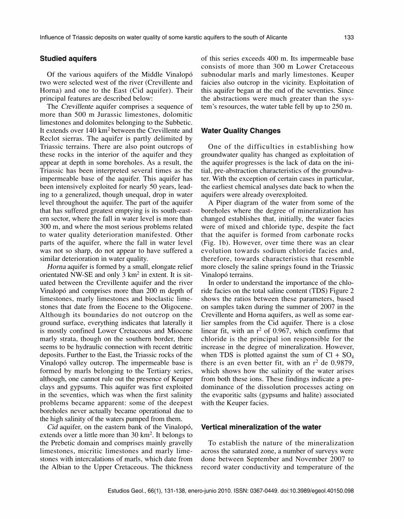
Of the various aquifers of the Middle Vinalopótwo were selected west of the river (Crevillente andHorna) and one to the East (Cid aquifer). Theirprincipal features are described below:
The Crevillente aquifer comprises a sequence ofmore than 500 m Jurassic limestones, dolomiticlimestones and dolomites belonging to the Subbetic.It extends over 140 km2 between the Crevillente andReclot sierras. The aquifer is partly delimited byTriassic terrains. There are also point outcrops ofthese rocks in the interior of the aquifer and theyappear at depth in some boreholes. As a result, theTriassic has been interpreted several times as theimpermeable base of the aquifer. This aquifer hasbeen intensively exploited for nearly 50 years, lead-ing to a generalized, though unequal, drop in waterlevel throughout the aquifer. The part of the aquiferthat has suffered greatest emptying is its south-east-ern sector, where the fall in water level is more than300 m, and where the most serious problems relatedto water quality deterioration manifested. Otherparts of the aquifer, where the fall in water levelwas not so sharp, do not appear to have suffered asimilar deterioration in water quality.
Horna aquifer is formed by a small, elongate relieforientated NW-SE and only 3 km2 in extent. It is sit-uated between the Crevillente aquifer and the riverVinalopó and comprises more than 200 m depth oflimestones, marly limestones and bioclastic lime-stones that date from the Eocene to the Oligocene.Although its boundaries do not outcrop on theground surface, everything indicates that laterally itis mostly confined Lower Cretaceous and Miocenemarly strata, though on the southern border, thereseems to be hydraulic connection with recent detriticdeposits. Further to the East, the Triassic rocks of theVinalopó valley outcrop. The impermeable base isformed by marls belonging to the Tertiary series,although, one cannot rule out the presence of Keuperclays and gypsums. This aquifer was first exploitedin the seventies, which was when the first salinityproblems became apparent: some of the deepestboreholes never actually became operational due tothe high salinity of the waters pumped from them.
Cid aquifer, on the eastern bank of the Vinalopó,extends over a little more than 30 km2. It belongs tothe Prebetic domain and comprises mainly gravellylimestones, micritic limestones and marly lime-stones with intercalations of marls, which date fromthe Albian to the Upper Cretaceous. The thickness
of this series exceeds 400 m. Its impermeable baseconsists of more than 300 m Lower Cretaceoussubnodular marls and marly limestones. Keuperfaicies also outcrop in the vicinity. Exploitation ofthis aquifer began at the end of the seventies. Sincethe abstractions were much greater than the sys-tem’s resources, the water table fell by up to 250 m.
Water Quality Changes
One of the difficulties in establishing howgroundwater quality has changed as exploitation ofthe aquifer progresses is the lack of data on the ini-tial, pre-abstraction characteristics of the groundwa-ter. With the exception of certain cases in particular,the earliest chemical analyses date back to when theaquifers were already overexploited.
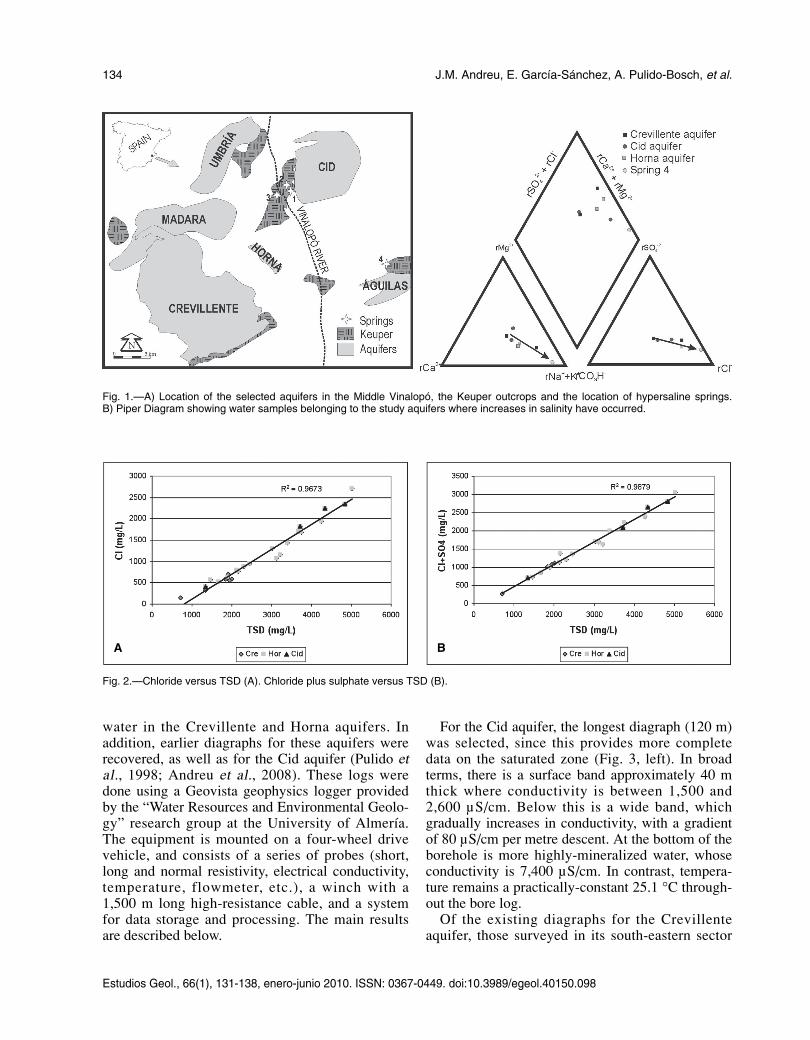
A Piper diagram of the water from some of theboreholes where the degree of mineralization haschanged establishes that, initially, the water facieswere of mixed and chloride type, despite the factthat the aquifer is formed from carbonate rocks(Fig. 1b). However, over time there was an clearevolution towards sodium chloride facies and,therefore, towards characteristics that resemblemore closely the saline springs found in the TriassicVinalopó terrains.
In order to understand the importance of the chlo-ride facies on the total saline content (TDS) Figure 2shows the ratios between these parameters, basedon samples taken during the summer of 2007 in theCrevillente and Horna aquifers, as well as some ear-lier samples from the Cid aquifer. There is a closelinear fit, with an r2 of 0.967, which confirms thatchloride is the principal ion responsible for theincrease in the degree of mineralization. However,when TDS is plotted against the sum of Cl + SO4there is an even better fit, with an r2 de 0.9879,which shows how the salinity of the water arisesfrom both these ions. These findings indicate a pre-dominance of the dissolution processes acting onthe evaporitic salts (gypsums and halite) associatedwith the Keuper facies.
Vertical mineralization of the water
To establish the nature of the mineralizationacross the saturated zone, a number of surveys weredone between September and November 2007 torecord water conductivity and temperature of the
Estudios Geol., 66(1), 131-138, enero-junio 2010. ISSN: 0367-0449. doi:10.3989/egeol.40150.098
Influence of Triassic deposits on water quality of some karstic aquifers to the south of Alicante 133
JY0-10 Andreu 9/6/10 14:32 Página 133
water in the Crevillente and Horna aquifers. Inaddition, earlier diagraphs for these aquifers wererecovered, as well as for the Cid aquifer (Pulido etal., 1998; Andreu et al., 2008). These logs weredone using a Geovista geophysics logger providedby the “Water Resources and Environmental Geolo-gy” research group at the University of Almería.The equipment is mounted on a four-wheel drivevehicle, and consists of a series of probes (short,long and normal resistivity, electrical conductivity,temperature, flowmeter, etc.), a winch with a1,500 m long high-resistance cable, and a systemfor data storage and processing. The main resultsare described below.
For the Cid aquifer, the longest diagraph (120 m)was selected, since this provides more completedata on the saturated zone (Fig. 3, left). In broadterms, there is a surface band approximately 40 mthick where conductivity is between 1,500 and2,600 µS/cm. Below this is a wide band, whichgradually increases in conductivity, with a gradientof 80 µS/cm per metre descent. At the bottom of theborehole is more highly-mineralized water, whoseconductivity is 7,400 µS/cm. In contrast, tempera-ture remains a practically-constant 25.1 °C through-out the bore log.
Of the existing diagraphs for the Crevillenteaquifer, those surveyed in its south-eastern sector
134 J.M. Andreu, E. García-Sánchez, A. Pulido-Bosch, et al.
Estudios Geol., 66(1), 131-138, enero-junio 2010. ISSN: 0367-0449. doi:10.3989/egeol.40150.098
Fig. 1.—A) Location of the selected aquifers in the Middle Vinalopó, the Keuper outcrops and the location of hypersaline springs.B) Piper Diagram showing water samples belonging to the study aquifers where increases in salinity have occurred.
Fig. 2.—Chloride versus TSD (A). Chloride plus sulphate versus TSD (B).
A B
JY0-10 Andreu 9/6/10 14:32 Página 134

were selected, since they were the only ones thatshow variation in the degree of mineralization ofthe water at depth. These logs also coincided withthe part of the aquifer that was most severely affect-ed by the deterioration in water quality, and wheremany boreholes were abandoned as a result. Bore-hole logs over the rest of the aquifer show stablewater quality throughout the water column. Electri-cal conductivity in the latter cases ranged between950 and 2,150 µS/cm depending on the aquiferpoint, values that coincide with the EC of the waterabstracted from the boreholes.
The water columns logged in the south-eastern sec-tor exceed 100 m in both cases (Fig. 3). In general,there is a slight increase in EC with depth. In boreholeT-6 (Fig. 3, right), one can differentiate the first 70 m,in which the water has an EC of between 2,354 and2,710 µS/cm. Below this is an approximately 10 mband where the sharpest rise in EC occurs, with amean gradient of close to 50 µS/cm/m. Lastly, the
water beneath has EC of more than 3,200 µS/cm.Temperature shows virtually no variation. In turn,borehole T-10 (Fig. 3 centre) shows alternating layersin which EC is constant in some bands and increasesin other. The least-mineralized water lies in the first14 m where mean EC is 3,300 µS/cm, whilst thedeepest part of the log records values close to4,200 µS/cm. Temperature, discounting the influenceof the ground surface, shows a slight increasing trend.
Three diagraphs are given for the Horna aquifer(Fig. 4), logged over 45 to 102 m. All show an upperband, 20 to 40 m thick, that corresponds to less-min-eralized water. Conductivity of this water is not thesame in all the boreholes, but varies between 1,600and 4,400 µS/cm. Whatever its value, EC is quitestable within this zone. Beneath, there is a consider-able and quite rapid increase in EC. Sometimes, thisrise in EC occurs in several jumps. Peak values arebetween 12,000 and 32,000 µS/cm depending on theaquifer point. This mineralized zone is also charac-
Estudios Geol., 66(1), 131-138, enero-junio 2010. ISSN: 0367-0449. doi:10.3989/egeol.40150.098
Influence of Triassic deposits on water quality of some karstic aquifers to the south of Alicante 135
Fig. 3.—Diagraphs of boreholes in the Cid (left) and Crevillente (T-10 centre and T-6 right) aquifers.
JY0-10 Andreu 9/6/10 14:32 Página 135
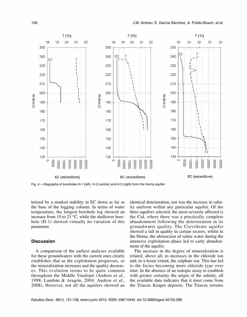
terized by a marked stability in EC down as far asthe base of the logging column. In terms of watertemperature, the longest borehole log showed anincrease from 19 to 21 °C, while the shallower bore-hole (H-1) showed virtually no variation of thisparameter.
Discussion
A comparison of the earliest analyses availablefor these groundwaters with the current ones clearlyestablishes that as the exploitation progresses, sothe mineralization increases and the quality decreas-es. This evolution seems to be quite commonthroughout the Middle Vinalopó (Andreu et al.,1998; Lambán & Aragón, 2004; Andreu et al.,2008). However, not all the aquifers showed an
identical deterioration, nor was the increase in salin-ity uniform within any particular aquifer. Of thethree aquifers selected, the most-severely affected isthe Cid, where there was a practically completeabandonment following the deterioration in itsgroundwater quality. The Crevillente aquifershowed a fall in quality in certain sectors, whilst inthe Horna, the abstraction of saline water during theintensive exploitation phase led to early abandon-ment of the aquifer.
The increase in the degree of mineralization isrelated, above all, to increases in the chloride ionand, to a lesser extent, the sulphate ion. This has ledto the facies becoming more chloride type overtime. In the absence of an isotopic assay to establishwith greater certainty the origin of the salinity, allthe available data indicates that it must come fromthe Triassic Keuper deposits. The Triassic terrains
136 J.M. Andreu, E. García-Sánchez, A. Pulido-Bosch, et al.
Estudios Geol., 66(1), 131-138, enero-junio 2010. ISSN: 0367-0449. doi:10.3989/egeol.40150.098
Fig. 4.—Diagraphs of boreholes H-1 (left), H-2 (centre) and H-3 (right) from the Horna aquifer.
JY0-10 Andreu 9/6/10 14:32 Página 136
are the only strata common to the three systemsand, despite the fact that they are all carbonateaquifers, their lithologies belong to different deposi-tional environments and different ages. Thus, theonly common link appears to be the Triassic Keuperdeposits.
The dissolution of halite appears to provide themain source of sodium and chloride in the ground-water of these aquifers, with water samples givingion ratios of close to unity in the majority of cases,similar to the case encountered in the saline spring4 (Fig. 1) and in other water related to the dissolu-tion of evaporite deposits in other geological con-texts (Grobe et al., 2002; Inoubli, 2005). Only inthe Horna aquifer is the ionic ratio slightly lower(0.7-1), and this could be explained by the inter-vention of other water-rock interactions (thisaquifer contain marl-rich sequences) that upset theion ratio.
Other aspect worth highlighting is that not all ofthe points show the same degree of deterioration, noteven within the sectors affected by the salinization.The diagraphs for some abstraction points show thatthe most-mineralized water is at the base of theboreholes, which suggests differentiation by gravityof water within the aquifer. This kind of hydrochem-ical disposition has been highlighted in many aquiferformations whose saline wedges are the result ofdissolution of evaporite deposits and mixing withbrines (Tellman, 1986; Hanor & Mcintosh, 2007).Of the three aquifers logged, the greatest variation inmineralization between the surface and bottomwater was in the Horna aquifer, where differences inEC of nearly 30,000 µS/cm were recorded.
The hydrochemical disposition could explainwhy the deepest boreholes would pump a watermixture with a higher proportion of basal water andtherefore more saline water, whilst shallower bore-holes nearby would basically pump water the moredilute surface water. Such a situation appears in theHorna aquifer, where the shallowest boreholesdeliver less mineralized water. In addition, thishydrochemical zoning implies that, as the aquiferbecomes desaturated as a consequence of overab-straction, the ratio of mixing between the fresh andthe saline moves in favour of the saline water sothat, over time, an increase is noted in the degree ofmineralization of the water extracted.
Hydrogeochemical zoning seems to be evident toa greater or lesser extent in each of the threeaquifers, and could explain part of the change inwater quality that occurs as overexploitation of the
aquifer progresses. However, there does not seem tobe a direct correlation between depth and theincrease in mineralization. In spite of the fact thatonly a small number of boreholes were logged andthe information obtained may still be biased as aresult, it is possible to confirm that each boreholehas a distinct mineralization profile. Even whenpoints from the same aquifer are compared, thejumps in mineralization occur at different levels, inspite of the geographical proximity of the points.This invalidates the idea of a static hydrochemicaldifferentiation, although it is conceivable that thekarstic character of these aquifers, whereby flows inthe saturated zone are determined by the greater orlesser transmissivity of the rock in different parts,could be the explanation for why a static differenti-ation would be modified or disturbed.
ACKNOWLEDGEMENTS
This study was financed from the research projectsCGL2004-03627/HID from the CYCIT and GV07/143 fromthe Generalitat Valenciana; it was undertaken in the frameworkof the UNESCO project IGCP-513. We are grateful to the per-sonnel of SAT 3412 from Aspe for allowing and assisting theborehole loggings in their installations.
References
Andreu, J.M.; Estévez, A.; Morell, I. & Pulido-Bosch, A.(1998). La contaminación de acuíferos kársticos ligadaa la sobreexplotación. In: La contaminación de lasaguas subterráneas: un problema pendiente (Samper,J.; Sahuquillo, A.; Capilla, J.E. & Gómez, J.J., eds.),ITGE, Madrid, 335-361.
Andreu. J.M.; García-Sánchez, E.; Jorreto, S.; Francés &Pulido-Bosch, A. (2008). Evaluación de la calidad delagua subterránea en la actual zona saturada delacuífero de Crevillente (Alicante). Geogaceta, 44: 151-154.
Custodio. E. (1993). Hydrogeological and hydrochemicalaspects of aquifer overexploitation. In: Aquifer overex-ploitation. Selected papers on Aquifer overexploitationfrom the 23rd International Congress of the Interna-tional Association of Hydrogeologists, Verlag HeinzHeise, Hanover, 3: 3-27.
Custodio, E. (2002). Aquifer overexploitation: what doesit mean? Hydrogeology Journal, 10: 254-277. doi:10.1007/s10040-002-0188-6
Elliot T.; Andrew, J.N. & Edmunds W.E. (1999). Hydro-chemical trends, paleorecharge and groundwater agesin the fissured Chalk aquifer of the London and Berk-shire basins, UK. Applied Geochemistry, 14: 333-363.doi:10.1016/S08832927(98)00060-2
Estudios Geol., 66(1), 131-138, enero-junio 2010. ISSN: 0367-0449. doi:10.3989/egeol.40150.098
Influence of Triassic deposits on water quality of some karstic aquifers to the south of Alicante 137
JY0-10 Andreu 9/6/10 14:32 Página 137
Grobe M. & Machel, H.G. (2002). Saline groundwater inthe Münsterland Cretaceous Basin, Germany: clues to itsorigin and evolution. Marine and Petroleum Geology,19: 307-302. doi:10.1016/S0264-8172(02)00019-3
Gunn, J.; Bottrell, S.H.; Lowe, D.J. & Worthington,S.R.H. (2006). Deep groundwater flow and geochemi-cal processes in limestone aquifers: evidence from ther-mal water in Derbyshire, England. UK. HydrogeoogyJournal, 14:868-881. doi:10.1007/s10040-006-0022-7
Hanor, J.S. & McInstosh, J.C. (2007). Diverse originsand timing of formation of basinal brines in the Gulf ofMexico sedimentary basin. Geofluids, 7: 227-237.doi:10.1111/j.14688123.2007.00177.x
Harou, J.J. & Lund (2008). Ending groundwater overdraftin hydrologic-economic systems. Hydrogeoogy Journal,16: 1039-1055. doi:10.1007/s10040-008-0300-7
Inoubli, N.; Bouri, S. Gouasmia, M. & Ben Dhia H.(2005). Geothermal waters in relation with TriassicEvaporitic Structures (Norh-Western, Tunisia). Pro-ceedings of the World Geothermal Congress, Antalya,Turkey: 1-5.
Kinniburgh, D.G.; Gale, I.N.; Smedley, P.L.; Darling,W.G.; West, J.M.; Kimbling, R.T.; Parker, A.; Rae,J.E.; Aldous, P.J. & O’Shea, M.J. (1994). The effectsof abstraction of groundwater fom the London Basinaquifers on groundwater quality. Applied Geochem-istry, 9: 175-195.
Lambán, L.J. & Aragón, R. (2004). Influence of inten-sive exploitation on groundwater salinity: the Quibashydrogeological unit (Murcia, SE Spain). In: Ground-water and saline intrusion. Selected papers from the18th Salt Water Intrusion Meeting, Cartagena, Spain(Araguás, L.; Custodio, E. & Manzano, M., eds.). Pub-licaciones del IGME, Serie Hidrogeología y aguas sub-terráneas, 15: 551-563.
Leret, G.; Núñez, A.; Colodrón, I. & Martínez del Olmo,W. (1976). Mapa y memoria explicativa de la hoja 981(Elda) del Mapa Geológico Nacional a escala1:50.000. Plan MAGNA, IGME, Madrid.
Magri, F.; Bayer U.; Rekdeger, A.; Otto, R. Thomsen, C.& Maiwald, U. (2009). Salty groundwater flow in theshallow and deep aquifer systems of the Schleswig-Holstein area (North German Basin). Tectonophysics,470: 183-194. doi:10.1016/j.tecto.2008.04.019
Mancheño, M.A. & Rodríguez-Estrella, T. (1985).Geología de los diapiros triásicos en el noreste de laprovincia de Murcia. Estudios Geológicos, 41: 189-200. doi:10.3989/egeol.85413-4701
Marie A & Vengosh A. (2001). Sources of salinity ingroundwater from Jericó area Jordan Valley. GroundWater, 39: 240-248. doi:10.1111/j.17456584.2001.tb02305.x
Ortí, F. (1974). El Keuper del Levante español. EstudiosGeológicos, 30: 7-46.
Pulido-Bosch, A.; Morell, I. & Andreu, J.M. (1996).Modifications hydrogéochimiques provoquées para lasurexploitation d’un aquifère karstique, Comptes Ren-dus de la Academie de Science de Paris, 323, ser II:313-318.
Pulido-Bosch, A.; Andreu, J.M.; Estévez, A. & Ayanz, J.(1998). Zonation hydrogéochimique verticale dansl’aquifère karstique du Cid (Alicante, Espagne).Comptes Rendus de la Academie de Science de Paris,326, ser II: 421-426.
Sophocleous, M. (2002). Interactions between ground-water and surface water: the state of the science.Hydrogeology Journal, 10: 52-67. doi:10.1007/s10040-001-0170-8
Tellman, J.H.; Lloyd, J.W. & Walters, M. (1986). Themorphology of a saline groundwater body: its investi-gation, description and possible explanation. Journalof Hydrology, 83:1-21.
Vengosh, A. & Rosenthal, E. (1994). Saline groundwaterin Israel: its bearing on the water crisis in the country.Journal of Hydrology, 156: 389-430. doi:10.1016/00221694(94)900876
Vrba, J. (2003). The impact of aquifer intensive use ongroundwater quality. In: Intensive use of groundwater:challenges and opportunities (Llamas, R. & Custodio,E., eds.) Balkema, Madrid: 113-132.
Zektser, S.; Loáiciga, H.A. & Wolf, J.T. (2005). Envi-ronmental impacts of groundwater overdraft: selectedcase studies in the southwestern United States. Hydro-geology Journal, 47: 396-404.
Recibido el 3 de diciembre de 2009Aceptado el 24 de febrero de 2010
Publicado online el 22 de abril de 2010
138 J.M. Andreu, E. García-Sánchez, A. Pulido-Bosch, et al.
Estudios Geol., 66(1), 131-138, enero-junio 2010. ISSN: 0367-0449. doi:10.3989/egeol.40150.098
JY0-10 Andreu 9/6/10 14:32 Página 138