Embed Size (px)
Citation preview

Information System as a Tool forMarine Spatial Planning
The SmartSea Vision and a Prototype
Ari Jolma
Marine Research Centre
Finnish Environment Institute
May 10, 2017
ISESS 2017, Zadar, Croatia

● Context and motivation● Marine Spatial Planning● Requirements● Information environment● Prototype
○ Database○ Dynamic map service
2
Contents of the talk
Ari Jolma, ISESS 2017

● Finland is investing in strategic research with an emphasis on strong societal impact
● Seas and oceans are recognized as drivers for European economy and having great potential for innovation and growth
● ”SmartSea” is a joint effort to take a multi-disciplinary look at the Gulf of Bothnia of the Baltic Sea
3
Context and motivation
Gulf of Bothnia is a shallow, relatively undevelopedsea area that hasan area of 117 000 km2
Ari Jolma, ISESS 2017

4
Maritime Spatial Planning (MSP)
Environmental sustainability● e. health, production, resiliency
Social needsEconomic development● Offshore wind energy● Seabed mining● Marine biotechnology● Aquaculture● Coastal turism● Transportation● ...
Climatechange
Security
Long-termperspective
Integratedassessment
Public,collaborativeprocess
Ari Jolma, ISESS 2017
Political process

● Access to existing spatial data● Understanding spatial interactions● Management of multiple objectives● Collaborative/participatory data collection● Site selection● Impact assessment● Understanding and assessing cumulative impacts● Environmental valuation● Conflict assessment● Collaborative conflict resolution● Embracing change, learning, and adapting● ...
=> no one tool satisfies all requirements5
Requirements for an information system supporting MSP
Ari Jolma, ISESS 2017

● A concept for user-centered analysis● Preferred tools● Organization policies● Standards for data access/transfer● Internet● Open access to data, Free and open source software
● MSP
– Communities: Planners, Researchers, Stakeholders, Public
– Platforms: Collaboration, Participatory Mapping, Decision Support
6
Information environment
Ari Jolma, ISESS 2017

● Dynamics● Multiple levels of planning● Planning is still unstructured● Sectoral ambitions are strong● Spatial focus can be on large areas or local● Temporal horizon can vary considerably
7
Characteristics of MSP
Ari Jolma, ISESS 2017

● Integrative database○ Datasets○ Planning (spatial modeling)○ Model for environmental impact
● Dataset development● Database design● Services
○ Modeling API○ WMTS
● Browser client● Desktop GIS client
8
Prototype
Ari Jolma, ISESS 2017

● The planning process: what is being done?● The input datasets: from where?, how they are produced?● Presentation styles● Spatial modeling: where are good locations for this? what is
this location good for?● Activities cause pressures on the environment, pressures
cause impacts on ecosystem components
● … work in progress:● Impact modeling, spatial impacts● Combination of pressures and impacts● Risk assessment
9
Integrative database
Ari Jolma, ISESS 2017

Database 1/3
● Two levels of planning:1. define types of uses and
layers 2. allocate areas for uses
● Use class = what uses are allowed / disallowed in a zone
● Layer class = ”Suitability”, ”Allocation”, ”Value”, ”Impact”, etc.
● Rule system = how the suitability/value/something else is computed and from what data

From resultsTo data

Database 2/3
● A specific use class implies specifc activities will take place
● A specific activity causes a specific pressure in a given range
● A specific pressure causes a specific impact on a given ecosystem component
● Impacts on ecosystem components can be combined


Database 3/3
● Impacts on ecosystem components should be combined spatially

● RDBMS (PostgreSQL) (SQLite for tests)○ > 30 tables, heavy use of foreign keys
● ORM (DBIx::Class)○ Classes for each table○ Objects represent rows in tables or selects on tables○ Automates references and relationships
● Wrapper class for a ”generic” web-page (HTML) oriented CRUD (create-read-update-delete) API○ Conceptual ”parent-child” relationship can take many
forms in the RDBMS and ORM is not (at least a full) a solution
○ A RESTful API may be what is needed a little further down the line
15
Database technology stack
Ari Jolma, ISESS 2017

● Service of map tiles of predefined content, extent, and resolution
● Limited set of resolutions○ One step finer resolution tile is ¼ of a tile of coarser
resolution
● Very good user experience in a browser● WMTS is commonly viewed as a service of predrawn tiles
○ In this work we implemented a plugin mechanism to modify or create the requested tiles
● Depending on the client library (QGIS: no, OpenLayers: yes) the ”predefined content” rule can be relaxed
16
Web Map Tile Service (WMTS)
Ari Jolma, ISESS 2017

Client HTTPserver
OWSserver
WM(T)Sserver
Tileserver
Tileproducer
GDAL
Nginx, Starman, Plack
WMTS class
OWS Service class
File-system
WMTS 1/2
● Serving a map tile can happen according to several standards but has a typical pipeline
● Typically tiles are stored as files in a file system
● With some additional code tiles can be generated on-the-fly by, e.g., clipping a single (or virtual) file

Client HTTPserver
OWSserver
WM(T)Sserver
Tileserver
Tileproducer
GDAL
Tileprocessor
Configurationgenerator
Nginx, Starman, Plack
SmartSea plugin class
WMTS class
OWS Service class
SmartSeaMSP tool
DB
File-system
WMTS 2/2
● Hooking a plugin into specific locations in the service, it can be turned into a dynamic service
● Even more dynamism can be added to the service by user identification (cookies, user authentication)
● OpenLayers WMTS client does not query capabilities, QGIS does => less flexibility with QGIS
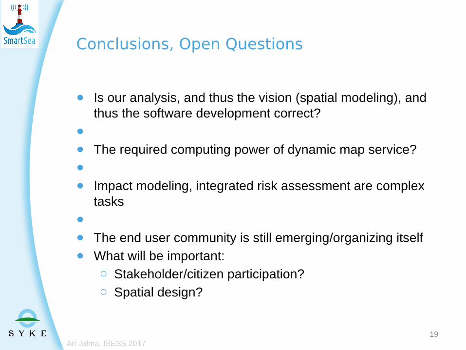
● Is our analysis, and thus the vision (spatial modeling), and thus the software development correct?
●
● The required computing power of dynamic map service?●
● Impact modeling, integrated risk assessment are complex tasks
●
● The end user community is still emerging/organizing itself● What will be important:
○ Stakeholder/citizen participation?○ Spatial design?
19
Conclusions, Open Questions
Ari Jolma, ISESS 2017