Embed Size (px)
Citation preview

1
FM Flood Risk Management District No. 1
Informational Meeting
www.fmdiversion.com/assessments

WELCOME
Meeting format:
• 5:30 – 6:00 Open House
• 6:00 – 6:45 Presentation
• 6:45 – 7:30 Open House
2

• The Cass County Joint Water Resource District (CCJWRD) is a member of the Diversion Authority.
• CCJWRD has the ability under the North Dakota Century Code to administer an assessment district throughout the benefitted area in North Dakota.
• CCJWRD formed the Diversion Project Assessment Committee (DPAC), which includes representatives from Fargo, West Fargo, Cass County, and the CCJWRD board.
• DPAC worked for over 2 years to establish a methodology to assign direct and indirect benefits across the benefiting area.
• All property owners receiving an assessment receive a vote
3
CCJWRD TO ADMINISTER ASSESSMENT DISTRICT

4
Information Topics to be Discussed:
• Flooding and the need for flood protection
• FM Area Diversion Project
• Need for financing
• Development of the assessment district
• Ballot and voting information packet
WHY ARE WE HERE?

FLOODING AND THE
NEED FOR THE PROJECT

ADD A PICTURE
6
FLOODING IS THE PROBLEM

January 31, 2014 7
ADD A PICTURE
7
FLOODING IS THE PROBLEM
Interstate 29 near Harwood Closed April 10. Reopened April 15, 2011.
Detour added = 22.8 miles
January 31, 2014 8
ADD A PICTURE
8
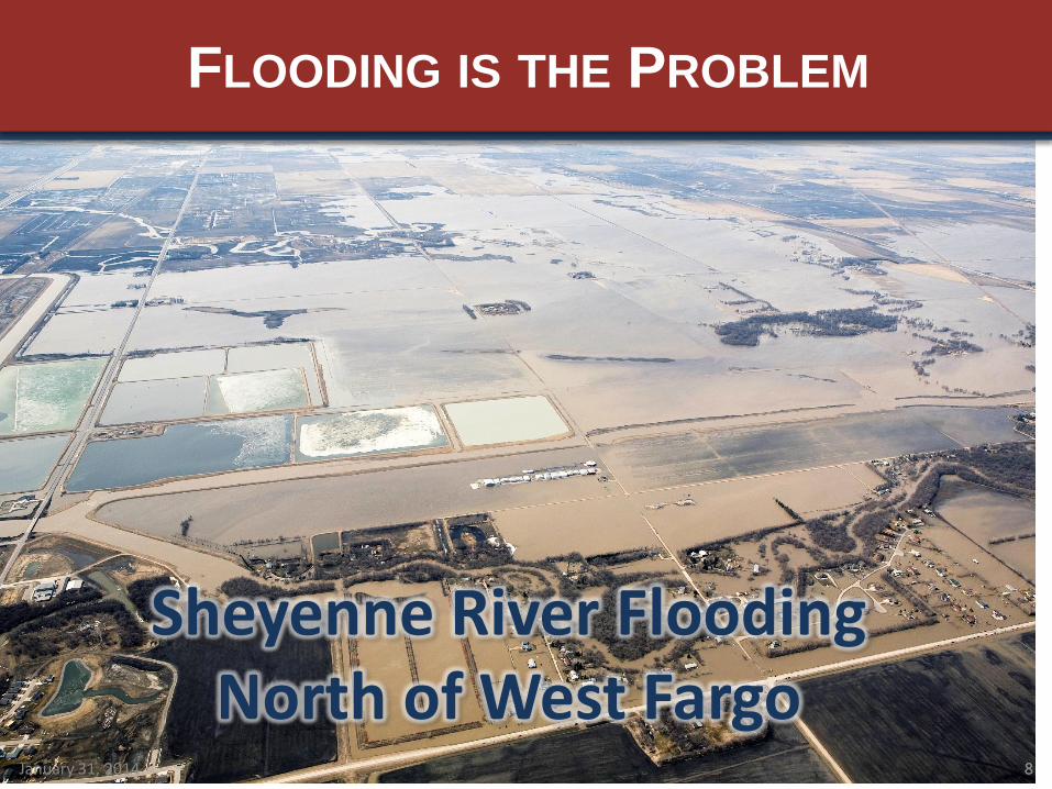
FLOODING IS THE PROBLEM
Sheyenne River Flooding North of West Fargo

9
• Red River Flood Stage = 18 feet on the Fargo gage
• Exceeded in 50 of the past 111 years
• Exceeded 20 of the last 21 years
• Catastrophic damages have been prevented by emergency
measures
• 8 of the 16 “major” floods on record have occurred since
2000
• 2009 was the flood of record
• Stage of 40.8 feet
• 2-percent chance (50 year) event
• Emergency measures cost approximately $70M
• Cost of losing would have been astronomical
RED RIVER FLOODING HISTORY

Pre-2015 FEMA Floodplain 38.5 Feet River Gage (29,300 cfs) 475 Impacted Structures 19,700 Acres Impacted
2015 FEMA Floodplain 39.4 Feet River Gage (29,300 cfs) Approx. 2,300 Impacted Structures 27,600 Acres Impacted
Future USACE Floodplain 41.1 River Gage (34,700 cfs) Approx. 19,400 Impacted Structures 36,430 Acres Impacted
EVER CHANGING FLOODPLAIN RISK

Project 1 Protection from Sheyenne River – greater
than 500-year Protection from Red River – between 100-
year and 500-year
Project 2 Protection from Sheyenne River – 100-year
Split flow design Relies on perched riverbanks and
emergency measures along Sheyenne River
Risk of ice jams in Sheyenne River Protection from Red River – between 100-
year and 500-year
SHEYENNE RIVER DIVERSION

Project 1 Protection from Red River – greater than
500-year Reduced flow in Sheyenne Diversion
Potential to lower maintenance costs
Project 2 Protection from Red and Sheyenne Rivers –
greater than 500-year Reduced flow in Sheyenne Diversion
Potential to lower maintenance costs
Lowers water surface elevation within Sheyenne River Reduces threat of ice jams Reduces reliance on perched river banks and
emergency measures along Sheyenne River
RED RIVER DIVERSION BENEFITS TO SHEYENNE RIVER DIVERSION

FM AREA
DIVERSION PROJECT

• Federally Authorized Project
• 1,600 ft wide Diversion Channel in ND with 150,000 acre-feet of Upstream Staging
• Selected after federal feasibility study of all alternatives
• Provides 1-percent (100-year) Risk Reduction
• Extreme Events are Flood-Fightable
FM AREA DIVERSION PROJECT

15
Federal Cost
Share Non-Federal
Cost Share
$175M
ND State (to date)
$725M
=
$450M
Local
+
$275M
ND State (remaining)
$100M MN
$800M
$1,000M
OVERALL FUNDING APPROACH

Local Funding
• Voters have approved two dedicated sales tax measures for flood protection
• Sales tax projections estimate collections to total $700 Million over the remainder of the taxes
– More than covers the local cost share
ND State Funding
• State legislature has appropriated $175M with legislative intent to give another $275M
16
FUNDING SOURCES TO DATE

17
STRONG HISTORY OF SALES TAX REVENUE

NEED FOR FINANCING

• Construction costs will outpace the sales tax revenues
• Financing will be required in order to construct the Diversion Project efficiently and in a timely manner
• Even with a strong historical record, sales tax financing would cost more than the special assessment alternative
19
NEED FOR FINANCING

20
CONSTRUCTION COSTS OUTPACE SALES TAX REVENUES

Financing Option Short-Term Long-Term
Pay-Go
Capital Financing Program – ND Public Finance Authority Program (Sales Tax Revenue Bond)
Bank of North Dakota Loan
General Obligation Bonds
Direct-Funded Loan (Bank Financing)
Special Assessment Backed Bonds
SHORT-TERM AND LONG-TERM FINANCING OPTIONS

22
• Assessment District will Provide Better Borrowing Terms
– Lower Interest Rate
– Lower Coverage Requirements
• Assessment District will Save Taxpayers Money
• Assessment District could Provide Operating Revenue for Maintenance
WHY SPECIAL ASSESSMENT DISTRICT FINANCING?

• Estimated Project Cost = $1,781.5M
• Less State of North Dakota Funding (to date) - $175.0M
• Less Estimated Federal Funding - $801.5M
• Less Estimated State of Minnesota Funding - $100.0M
Project Cost to Finance / Assess = $725.0M
(Project Cost Estimates are Based on Federal Environmental Impact Statement)
DIVERSION PROJECT COST TO ASSESS

DEVELOPMENT OF
THE ASSESSMENT DISTRICT

Direct Benefits Indirect Benefits Acquired Right of Way
Measured Benefits to Individual Parcels
Global Benefits Assigned to Jurisdictions
Voting Power to Impacted Parcels
Consider: • Flood Risk Reduction • Existing Protection Level • Property Value Protected •Area Protected
Consider: • Infrastructure •Community & Lifestyle •Business & Economy • Salient Benefits
Consider: • Fixed Voting Amount Based
on County Assessor’s Value of Lands Impacted
Vote by Property Owners (Vote is equal to dollars assessed) 49,208 Ballots
Vote by Jurisdiction Leaders (Vote is equal to dollars assessed) 20 Ballots
Vote by Property Owners (Vote is equal to assessor’s value of impacted property) Parcels receive no assessments 901 Ballots
25
WHO GETS A VOTE?

• Assessments to property are determined by benefit
region, property value (true & full), and total area of
the parcel
• Benefit regions incorporate:
– Existing floodplains – Project-specific floodplains – FEMA floodplain information – Elevation models – Local knowledge & professional expertise
• Utilized scientific flood risk reduction analysis to
group parcels & neighborhoods with similar benefits
into benefit regions
• The same benefit methodology was applied to all
parcels 26
DIRECT BENEFITS

27
• Property owners being asked to “Co-Sign” the loan
• Sales taxes will pay the “Mortgage Payment”
• Special assessments will not be certified to property as long as sales tax revenues are sufficient
• Assessments will still be a liability against the property
• Assessment liability will reduce over time
DIRECT ASSESSMENTS

• Assessments will not be certified to property as long as sales tax revenues are sufficient
• Uncertified special assessments do not appear on property tax bills
• Assessments will still be considered liabilities against the property in terms of real estate transactions
• Assessments will reduce over time as annual payments from sales tax revenues are made and as assessment liabilities are redistributed due to reinvestment in the community
28
CERTIFIED VS. UNCERTIFIED

29
PROPERTY LIABILITY OVER 30 YEARS

• Example “liability” for a home valued at $200,000:
– In South Fargo
• $5,909 Total Initial Liability, $363 Annually
– In West Fargo
• $788 Total Initial Liability, $48 Annually
• Liability will be reduced Annually through Sales Tax Payments and Continued Regional Growth
• Flood Insurance Policy in South Fargo Approximately $2,000-$4,000 Annually
30
PROPERTY ASSESSMENTS

Location Average
Home Value Total Assessment
Liability
West Fargo (N. of I94)
$166,525 $655
Horace & West Fargo (S. of I94)
$201,877 $1,200
North of West Fargo / Reiles Acres / West Harwood
$173,008 $7,448
Fargo (S. of I94) $199,357 $5,900 31
AVERAGE HOME ASSESSMENTS

BALLOT AND VOTING
PACK INFORMATION

• Three versions of the Cover Letter are below.
– Direct Benefit Ballot Cover Letter (sent to benefiting parcels)
– Indirect Benefit Ballot Cover Letter (sent to benefiting counties, townships, and cities)
– ROW Impacted Ballot Cover Letter (sent to impacted parcels)
• Sample Ballot
• Ballot Information and Instructions
• Notice of Hearing
• Benefit Region Map
• Resolution Determining Benefitted Property
• Preliminary Assessment List
• Engineer's Report
• Available at www.fmdiversion.com/assessments
33
BALLOT PACKET CONTENTS

34
SAMPLE BALLOT

• If ownership information has changed, please request a corrected ballot
– Call Cass County Joint Water Resources District (701) 298-2381
• All property owners listed on ballot should sign in order to get the full weight of the vote
• In case of multiple owners, ballot will only be sent to the address in the county database
35
VOTING INFORMATION AND INSTRUCTIONS

• Only original signatures on ballots will be accepted. Ballots emailed or faxed will not be accepted
• Ballots must be returned by 5:00pm April 30, 2015
– Return envelope is included
• Vote is successful if 50 percent or more of the weight of the returned ballots indicate a YES vote
36
VOTING INFORMATION AND INSTRUCTIONS

37
QUESTIONS?

Benefit Region Average
Assessment per Acre
Hypothetical Annualized Amount per Acre
Benefit Region 1 (25% Benefit) $68 ~ $4
Benefit Region 2 (100% Benefit) $271 ~ $16
38
AGRICULTURAL ASSESSMENTS
• Ag-Land makes up approximately 1.2% of the total assessment amount
• Ag-Land makes up over half the total area
• Benefit to Ag-land was determined by the benefit region, the county valuation (not market value), and by total acreage. The same formula as is applied to all property.