Embed Size (px)
Citation preview

CG Development Tentative Subdivision Map (TSM20-0001) 1
Butte County Department of Development Services March 2021
INITIAL STUDY AND ENVIRONMENTAL REVIEW CHECKLIST California Environmental Quality Act (CEQA)
PROJECT INFORMATION
1. Project Title: Tentative Subdivision Map (TSM20-0001)
2. Lead Agency Name and Address: Butte County – Department of Development Services
Planning Division
7 County Center Drive
Oroville, CA 95965
3. Contact Person and Phone Number: Mark Michelena, Senior Planner
530.552-3683; [email protected]
4. Project Location: The project parcel is approximately 18.9 acres and located on the
northeast side of Nord Avenue, approximately 1,750 feet southeast of
Bell Road, north and west of Chico. Section 99, Range; MDB&M. APN:
042-020-010. Latitude 39°45’15.084”N, Longitude 121°53’26.491”W
5. Project Sponsor’s Name and Address: CG Development (Chris Giampaoli)
901 Bruce Road, Suite 100
Chico, CA 95928
6. General Plan Designation: Very Low Density Residential (VLDR)
7. Zoning: VLDR-1.0 (Very Low Density Residential 1-acre minimum)
8. Description of Project: (Describe the whole action involved, including but not limited to later phases of the project,
and any secondary, support, or off-site features necessary for its implementation. Attach additional sheets if
necessary.)
The project is a Tentative Subdivision Map to divide an approximately 18.9-acre property into 18 lots (ranging in size
from 1.01 to 1.19 acres). The project is proposed as a phased map. Phase I proposes eight (8) lots and Phase II proposes
ten (10) lots. Access to the two phases will be served by a cul-de-sac, served off of Nord Avenue. The project’s internal
roads will be offered for dedication to the County and will be maintained as part of a Permanent Road Division (PRD).
Future residential uses would be served by individual septic systems and individual wells.
Pursuant to the requirements of Butte County Code §24-56.1 (Residential Setback from Orchards and Vineyards), the
Department of Development Services in conjunction with the Agricultural Commissioner’s Office is recommending
as far as practical a residential dwelling setback from adjacent active orchards.
Lot Distance Location
1, 2, 3 and 4 50 feet Northwesterly property line

CG Development Inc Tentative Subdivision Map (TSM20-0001) 2
Butte County Deaprtment of Development Services March 2021
9. Surrounding Land Uses and Setting: (Briefly describe the project’s surroundings)
Existing land uses adjacent to the subject parcel are orchards and residential to the northwest, row crops and
residential to the east and residential to west. The project area primarily consists of rural residential, scattered
agricultural uses and vacant parcels, on parcel sizes that range in size from 0.33 to 20 acres.
Direction General Plan
Designation Zoning Existing Land Use(s)
North Very Low
Density
Residential
(VLDR)
VLDR Rural Residential/Vacant/Orchard
South VLDR VLDR Rural Residential/Orchard
East VLDR VLDR Rural Residential/Row Crops
West VLDR VLDR Rural Residential/Orchard
The project site is located within unincorporated Butte County and within the Sphere of Influence for the City of
Chico. The project site and surrounding area is zoned VLDR (Very Low Density Residential. The purpose of the
VLDR-1.0 zone is to allow for single-family homes and related uses in the residential neighborhoods within the
county. Standards for the VLDR zone are intended to preserve and protect the character of existing
neighborhoods and to ensure that new residential neighborhoods provide an appropriate transition from rural
to more developed areas. Permitted residential uses in the VLDR zones include single-family homes, small
residential care homes, second units and accessory dwelling units, animal grazing, on-site agricultural product
sales, and private stables. The VLDR zone also conditionally permits non-residential uses compatible with a
residential setting, including public and quasi-public uses, golf courses, park and recreational facilities, personal
services, animal-keeping, large residential care homes, and medical offices and clinics.
The topography of the subject property is gentle and flat, with elevations ranging from 160 to 165 feet above sea
level. Vegetation on the subject property is primarily grasses. The site had an orchard, but it was removed to
allow for the project’s future development.. The most prominent human-made features in the project area are
the rural residences, accessory structures, roads, utility lines, as well as the urban and suburban landscapes
surrounding Chico.
10. Other public agencies whose approval is required: (e.g., permits, financing approval, or participation agreement)
Butte County Department Development Services: Building Permits (Future Construction)
Butte County Public Works Department: Road and Grading Improvement Plans
Butte County Environmental Health (Future wastewater systems)
11. Have California Native American tribes traditionally and culturally affiliated with the project area requested
consultation pursuant to Public Resources Code section 21080.3.1? If so, is there a plan for consultation that
includes, for example, the determination of significance of impacts to tribal cultural resources, procedures
regarding confidentiality, etc.?
See Discussion 1.18
CG Development Inc Tentative Subdivision Map (TSM20-0001) 3
Butte County Deaprtment of Development Services March 2021
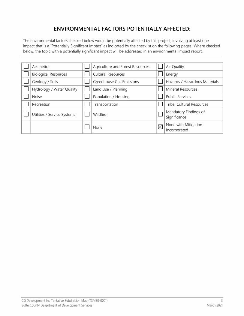
ENVIRONMENTAL FACTORS POTENTIALLY AFFECTED:
The environmental factors checked below would be potentially affected by this project, involving at least one
impact that is a “Potentially Significant Impact” as indicated by the checklist on the following pages. Where checked
below, the topic with a potentially significant impact will be addressed in an environmental impact report.
Aesthetics Agriculture and Forest Resources Air Quality
Biological Resources Cultural Resources Energy
Geology / Soils Greenhouse Gas Emissions Hazards / Hazardous Materials
Hydrology / Water Quality Land Use / Planning Mineral Resources
Noise Population / Housing Public Services
Recreation Transportation Tribal Cultural Resources
Utilities / Service Systems Wildfire Mandatory Findings of
Significance
None None with Mitigation
Incorporated

CG Development Inc Tentative Subdivision Map (TSM20-0001) 4
Butte County Deaprtment of Development Services March 2021
DETERMINATION (To be completed by the Lead Agency)
On the basis of this initial evaluation:
I find that the proposed project could not have a significant effect on the environment, and a
NEGATIVE DECLARATION will be prepared.
I find that although the proposed project COULD have a significant effect on the environment, there
WILL NOT be a significant effect in this case because revisions in the project have been made by or
agreed to by the project proponent. A MITIGATED NEGATIVE DECLARATION will be prepared.
I find that the proposed project MAY have a significant effect on the environment, and an
ENVIRONMENTAL IMPACT REPORT is required.
I find that the proposed project MAY have a “potentially significant impact” or “potentially significant
unless mitigated” impact on the environment, but at least one effect 1) has been adequately analyzed
in an earlier document pursuant to applicable legal standards, and 2) has been addressed by
mitigation measures based on the earlier analysis as described on attached sheets. An
ENVIRONMENTAL IMPACT REPORT is required, but it must analyze only the effects that remain to be
addressed.
I find that although the proposed project could have a significant effect on the environment, because
all potentially significant effects (a) have been analyzed adequately in an earlier EIR or NEGATIVE
DECLARATION pursuant to applicable standards, and (b) have been avoided or mitigated pursuant to
that earlier EIR or NEGATIVE DECLARATION, including revisions or mitigation measures that are
imposed upon the proposed project, nothing further is required.
Mark Michelena, Senior Planner Date
Dan Breedon, Interim Planning Manager Date
April 2, 2021
April 2, 2021

CG Development Inc Tentative Subdivision Map (TSM20-0001) 5
Butte County Deaprtment of Development Services March 2021
EVALUATION OF ENVIRONMENTAL IMPACTS
1. A brief explanation is required for all answers except “No Impact” answers that are adequately supported by
the information sources a lead agency cites in the parentheses following each question. A “No Impact”
answer is adequately supported if the referenced information sources show that the impact simply does not
apply to projects like the one involved (e.g., the project falls outside a fault rupture zone). A “No Impact”
answer should be explained where it is based on project-specific factors as well as general standards (e.g., the
project will not expose sensitive receptors to pollutants, based on a project-specific screening analysis).
2. All answers must take account of the whole action involved, including off-site as well as on-site, cumulative as
well as project-level, indirect as well as direct, and construction as well as operational impacts.
3. Once the lead agency has determined that a particular physical impact may occur, then the checklist answers
must indicate whether the impact is potentially significant, less than significant with mitigation, or less than
significant. “Potentially Significant Impact” is appropriate if there is substantial evidence that an effect may be
significant. If there are one or more “Potentially Significant Impact” entries when the determination is made,
an EIR is required.
4. “Negative Declaration: Less Than Significant With Mitigation Incorporated” applies where the incorporation of
mitigation measures has reduced an effect from “Potentially Significant Impact” to a “Less Than Significant
Impact.” The lead agency must describe the mitigation measures, and briefly explain how they reduce the
effect to a less than significant level (mitigation measures from “Earlier Analyses,” as described in (5) below,
may be cross-referenced).
5. Earlier analyses may be used where, pursuant to the tiering, program EIR, or other CEQA process, an effect
has been adequately analyzed in an earlier EIR or negative declaration. Section 15063(c)(3)(D). In this case, a
brief discussion should identify the following:
a) Earlier Analysis Used. Identify and state where they are available for review.
b) Impacts Adequately Addressed. Identify which effects from the above checklist were within the scope of
and adequately analyzed in an earlier document pursuant to applicable legal standards, and state whether
such effects were addressed by mitigation measures based on the earlier analysis.
c) Mitigation Measures. For effects that are “Less than Significant with Mitigation Measures Incorporated,”
describe the mitigation measures which were incorporated or refined from the earlier document and the
extent to which they address site-specific conditions for the project.
6. Lead agencies are encouraged to incorporate into the checklist references to information sources for
potential impacts (e.g., general plans, zoning ordinances). Reference to a previously prepared or outside
document should, where appropriate, include a reference to the page or pages where the statement is
substantiated.
7. Supporting Information Sources: A source list should be attached, and other sources used or individuals
contacted should be cited in the discussion.
8. This is only a suggested form, and lead agencies are free to use different formats; however, lead agencies
should normally address the questions from this checklist that are relevant to a project’s environmental
effects in whatever format is selected.
9. The explanation of each issue should identify:
a) the significance criteria or threshold, if any, used to evaluate each question; and
b) the mitigation measure identified, if any, to reduce the impact to less than significance.

CG Development Inc Tentative Subdivision Map (TSM20-0001) 6
Butte County Deaprtment of Development Services March 2021
Vicinity Map

CG Development Inc Tentative Subdivision Map (TSM20-0001) 7
Butte County Deaprtment of Development Services March 2021
Zoning Exhibit

CG Development Inc Tentative Subdivision Map (TSM20-0001) 8
Butte County Deaprtment of Development Services March 2021
Tentative Subdivision Map
CG Development Inc Tentative Subdivision Map (TSM20-0001) 9
Butte County Deaprtment of Development Services March 2021
1.1 AESTHETICS
ENVIRONMENTAL ISSUES
Potentially
Significant
Impact
Less Than
Significant with
Mitigation
Incorporated
Less Than
Significant
Impact
No
Impact
I. Aesthetics.
Except as provided in Public Resources Code section 21099 (where aesthetic impacts shall not be considered
significant for qualifying residential, mixed-use residential, and employment centers), would the project:
a) Have a substantial adverse effect on a scenic vista?
b) Substantially damage scenic resources, including, but
not limited to, trees, rock outcroppings, and historic
buildings within a state scenic highway?
c) In non-urbanized areas, substantially degrade the
existing visual character or quality of public views of
the site and its surroundings? (Public views are those
that are experienced from publicly accessible vantage
points.) If the project is in an urbanized area, would
the project conflict with applicable zoning and other
regulations governing scenic quality?
d) Create a new source of substantial light or glare
which would adversely affect day or nighttime views
in the area?
Setting
The project site area is characterized as Very Low Density Residential and agricultural lands situated in the rural valley
region of Butte County, approximately west of Chico, and approximately 0.4 miles northeast from State Highway 32.
Surrounding uses include rural residential and agriculture (orchards and row crops) on lots ranging from 0.33 to 20
acres.
The topography of the project area is gentle and flat, with elevations ranging from 160 to 165 feet above sea level.
Natural vegetation in the area consists of annual grasslands and orchards. The most prominent human-made features
are the rural residences, accessory structures, roads, utility lines, as well as the urban and suburban landscapes
surrounding Chico.
The Butte County General Plan depicts identified scenic resources in Butte County, including land-based and water-
based scenic resources (Figure COS-7), County scenic highways (Figure COS-8), and Scenic Highway Zones (Figure
COS-9). Based on the information provided in the General Plan, the project site is not located within, or in the v icinity
of, identified scenic resources.
Discussion
a) Have a substantial adverse effect on a scenic vista?
Less than significant impact. Future development of the proposed parcels includes single-family residential
units, which would be consistent with the established visual character and planned future use of the
surrounding area. Due to the low-density of the project, placement of additional residences will not significantly
interfere with the views of scenic vistas from adjacent residences and public right-of-ways. Therefore, the
project would not significantly affect a scenic vista nor have a demonstrable negative aesthetic effect.

CG Development Inc Tentative Subdivision Map (TSM20-0001) 10
Butte County Deaprtment of Development Services March 2021
b) Substantially damage scenic resources, including, but not limited to, trees, rock outcroppings, and historic buildings within a state scenic highway?
No impact. No improvements are proposed that could result in the damage or degradation of existing features
on or near the project site. Subsequent development of the resultant parcels is anticipated to be consistent
with the rural character of the project site and surrounding area. Additionally, the project site is not located
along a designated State or County scenic highway.
c) In non-urbanized areas, substantially degrade the existing visual character or quality of public views of the site and its surroundings? (Public views are those that are experienced from publicly accessible vantage points.) If the project is in an urbanized area, would the project conflict with applicable zoning and other regulations governing scenic quality?
Less than significant impact. Future development of the resultant parcels would consist of single-family
residences and accessory structures. The type of housing and the one-acre parcel sizes proposed would be
consistent with the rural character and quality of the project site and surrounding area.
d) Create a new source of substantial light or glare which would adversely affect day or nighttime views in the area?
Less than significant impact. Outdoor lighting for safety and security could potentially be added to existing
and future structures on the resultant parcels. However, the proposed very low-density development would
minimize ordinary nighttime lighting impacts to adjacent areas. Additionally, Article 14 of Butte County Code
requires that all outdoor lighting in residential areas be located, adequately shielded, and directed such that
no direct light falls outside the property perimeter, or into the public right-of-way. As a result, the proposed
project would not create new sources of substantial lighting or glare that would generate a significant impact.

CG Development Inc Tentative Subdivision Map (TSM20-0001) 11
Butte County Deaprtment of Development Services March 2021
1.2 AGRICULTURE AND FOREST RESOURCES
ENVIRONMENTAL ISSUES
Potentially
Significant
Impact
Less Than
Significant with
Mitigation
Incorporated
Less Than
Significant
Impact
No
Impact
II. Agriculture and Forest Resources.
In determining whether impacts to agricultural resources are significant environmental effects, lead agencies may
refer to the California Agricultural Land Evaluation and Site Assessment Model (1997, as updated) prepared by the
California Department of Conservation as an optional model to use in assessing impacts on agriculture and farmland.
In determining whether impacts to forest resources, including timberland, are significant environmental effects,
lead agencies may refer to information compiled by the California Department of Forestry and Fire Protection
regarding the state’s inventory of forest land, including the Forest and Range Assessment Project and the Forest
Legacy Assessment project; and forest carbon measurement methodology provided in Forest Protocols adopted
by the California Air Resources Board.
Would the project:
a) Convert Prime Farmland, Unique Farmland, or
Farmland of Statewide Importance (Farmland), as
shown on the maps prepared pursuant to the
Farmland Mapping and Monitoring Program of the
California Resources Agency, to non-agricultural use?
b) Conflict with existing zoning for agricultural use or a
Williamson Act contract?
c) Conflict with existing zoning for, or cause rezoning of,
forest land (as defined in Public Resources Code
section 12220(g)), timberland (as defined by Public
Resources Code section 4526), or timberland zoned
Timberland Production (as defined by Government
Code section 51104(g))?
d) Result in the loss of forest land or conversion of
forest land to non-forest use?
e) Involve other changes in the existing environment,
which, due to their location or nature, could result in
conversion of Farmland to non-agricultural use or
conversion of forest land to non-forest use?
Setting
The subject property is developed with a residential dwelling and accessory structures and is situated in the Very Low
Density Residential – one-acre minimum (VLDR – 1.0) zone district. The project site also includes an orchard. The Land
Use Element Map of the Butte County General Plan designates the project site as Very Low Density Residential (VLDR).
This land use designation is primarily for single-family homes with a minimum parcel size of 1 acre. The VLDR zone also
allows for limited agricultural uses including crop cultivation, animal grazing, private stables, animal services, as well as
roadside stands for the sale of agricultural products grown on the property as an interim use on parcels of one acre or
more in size, prior to subdivision and development with residential uses.

CG Development Inc Tentative Subdivision Map (TSM20-0001) 12
Butte County Deaprtment of Development Services March 2021
Regulatory Setting
Williamson Act/Land Conservation Act (LCA) Contracts
The California Land Conservation Act of 1965, commonly known as the Williamson Act, was established based on
numerous State legislative findings regarding the importance of agricultural lands in an urbanizing society. Policies
emanating from those findings include those that discourage premature and unnecessary conversion of agricultural
land to urban uses and discourage discontinuous urban development patterns, which unnecessarily increase the costs
of community services to community residents. The Williamson Act authorizes each County to establish an agricultural
preserve. Land that is within the agricultural preserve is eligible to be placed under a contract between the property
owner and County that would restrict the use of the land to agriculture in exchange for a tax assessment that is based
on the yearly production yield. The contracts have a 9-year term that is automatically renewed each year, unless the
property owner or county requests a non-renewal or the contract is cancelled.
Farmland Mapping and Monitoring Program
To characterize the environmental baseline for agricultural resources, Important Farmland Maps produced by the
California Department of Conservation’s Farmland Mapping and Monitoring Program (FMMP) were reviewed.
Important Farmland maps show categories of Prime Farmland, Farmland of Statewide Importance, Unique Farmland,
Farmland of Local Importance (if adopted by the county), Grazing Land, Urban and Built-up Land, Other Land, and
Water. Prime Farmland and Farmland of Statewide Importance map categories are based on qualifying soil types, as
determined by the U.S. Department of Agriculture (USDA), Natural Resources Conservation Service (NRCS), as well as
current land use. These map categories are defined by the Department of Conservation’s FMMP as follows:
Prime Farmland: Land which has the best combination of physical and chemical characteristics for the
production of crops. It has the soil quality, growing season, and moisture supply needed to produce sustained
high yields of crops when treated and managed, including water management, according to current farming
methods.
Farmland of Statewide Importance: Land that is similar to Prime Farmland but with minor shortcomings, such
as greater slopes or less ability to hold and store moisture.
Unique Farmland: Land of lesser quality soils used for the production of specific high economic value crops. It
has the special combination of soil quality, location, growing season, and moisture supply needed to produce
sustained high quality or high yields of a specific crop when treated and managed according to current farming
methods. It is usually irrigated, but may include non-irrigated orchards or vineyards as found in some climatic
zones in California. Examples of crops include oranges, olives, avocados, rice, grapes, and cut flowers.
Farmland of Local Importance: Land of importance to the local agricultural economy, as determined by each
county’s board of supervisors and local advisory committees. Examples include dairies, dryland farming,
aquaculture, and uncultivated areas with soils qualifying for Prime Farmland and Farmland of Statewide
Importance. Butte County has not adopted a definition of Farmland of Local Importance.
Grazing Land: Land on which the existing vegetation, whether grown naturally or through management, is
suitable for grazing or browsing of livestock.
Urban and Built-up Land: Land used for residential, industrial, commercial, construction, institutional, public
administrative purpose, railroad yards, cemeteries, airports, golf courses, sanitary landfills, sewage treatment
plants, water control structures, and other development purposes. Highways, railroads, and other
transportation facilities are also included in this category.
Other Land: Land not included in any other mapping category. Common examples include low density rural
developments; brush, timber, wetland, and riparian areas not suitable for livestock grazing; confined livestock,
poultry or aquaculture facilities; strip mines, borrow pits; and water bodies smaller than forty acres. Vacant and
nonagricultural land surrounded on all sides by urban development and greater than 40 acres is mapped as
Other Land.

CG Development Inc Tentative Subdivision Map (TSM20-0001) 13
Butte County Deaprtment of Development Services March 2021
Water: Water areas with an extent of at least 40 acres.
The project site is identified by the Department of Conservation as containing lands classified as Prime Farmland. Areas
surrounding the project site include Prime Farmland, Grazing Land, Urban and Built-up Land and Other Land. Just
further south and east is Urban and Built-up Land (City of Chico).
The Butte County General Plan 2030 Environmental Impact Report (GPEIR) considered the impacts resulting from the
build-out of the General Plan, including conversion of approximately 4,700 acres of Prime Farmland, Farmland of
Statewide Importance, and Unique Farmland to non-agricultural uses, including the Prime Farmland adjacent to the
subject property. The Butte County Board of Supervisors determined that goals, policies, actions, and regulations of
the General Plan would reduce and partially offset the conversion of farmland into non-agricultural uses, but found
that there are no feasible mitigation measures that the County could adopt to reduce the impact to be less than
significant. To the extent that this adverse impact will not be substantially lessened or eliminated, the County found
that specific economic, social, and other benefits identified in the Statement of Overriding Considerations supported
the approval of the General Plan.
Butte County Code (BCC) §24-56.1 - Residential Setback from Orchards and Vineyards
On January 12, 2016, the Butte County Board of Supervisors adopted amendments to the Butte County General Plan
and Zoning Ordinance to establish a setback requirement for new residential development adjacent to existing orchards
and vineyards located in residential zones. Butte County Code (BCC) §24-56.1 provides as follows:
24-56.1 Residential Setback from Orchards and Vineyards
A setback is established for residential development from existing orchards and vineyards that are located in
residential zones in order to reduce interference and conflict with preexisting agricultural operations, while
providing for the development potential allowed by residential zones. The residential setback from orchards and
vineyards is subject to the following requirements (Refer to Article 17. Agricultural Buffers, for agricultural buffer
setbacks required where a developing residentially zoned parcel is adjacent to a parcel zoned Agriculture):
A. A setback between a new residence and an existing active orchard or vineyard shall be established as far away
from the orchard or vineyard as practicable, taking into account adjacent agricultural uses and practices,
provided it does not limit the allowed residential density permitted by the residential zone, and in no case is
less than 25 feet.
B. Any proposed land division adjacent to an existing active orchard or vineyard use shall apply for a Residential
Setback Recommendation with the Development Services Department in accordance with this section. The
Residential Setback Recommendation shall be reviewed by the Agricultural Commissioner, in consultation with
Development Services to determine an appropriate setback width (pursuant to Subsection A.). The Residential
Setback Recommendation shall become part of the application and reviewed by the hearing body. Public
noticing shall include reference to the Residential Setback Recommendation and the residential setback’s
recommended width.
C. All building permits for residential development adjacent to existing orchards or vineyards shall be reviewed
for compliance with the required residential setback. If no residential setback is shown on an applicable
recorded parcel map or subdivision map, a review by the Zoning Administrator at a noticed public hearing
shall be conducted to determine the appropriate setback pursuant to Subsection A.
D. The residential setback shall be imposed from the property line (s) on the developing parcel and shown on the
recorded parcel map or subdivision map or building permit site plan.
E. The setback shall not apply to residential development adjacent to row crops or greenhouses and wholesale
nurseries primarily engaged in growing crops, plants, vines or trees and their seeds.
F. The setback shall not apply to backyard gardens and fruit and nut trees accessory to a residential use.
G. The setback shall not apply to accessory structures as defined under Section 24‐156 (Accessory Uses and
Structures) excepting guest houses, which must comply with the setback.

CG Development Inc Tentative Subdivision Map (TSM20-0001) 14
Butte County Deaprtment of Development Services March 2021
H. The setback shall not apply to orchard or vineyard uses that start operations after a building permit is approved
(this does not apply to an existing orchard or vineyard that is removed and replaced).
I. If the orchard or vineyard use is discontinued (i.e., the land is developed with residential uses) the setback shall
no longer be applicable.
The Department of Development Services in conjunction with the Agricultural Commissioner’s Office is recommending the
following residential dwelling setbacks from adjacent active orchard:
Lot Distance Location
1, 2, 3 and 4 50 feet Northwesterly property line
California Public Resources Code Section 4526
"Timberland" means land, other than land owned by the federal government and land designated by the board as
experimental forest land, which is available for, and capable of, growing a crop of trees of a commercial species used
to produce lumber and other forest products, including Christmas trees. Commercial species shall be determined by
the board on a district basis.
California Public Resources Code Section 12220(g)
"Forest land" is land that can support 10-percent native tree cover of any species, including hardwoods, under natural
conditions, and that allows for management of one or more forest resources, including timber, aesthetics, fish and
wildlife, biodiversity, water quality, recreation, and other public benefits.
Butte County Right to Farm Ordinance
Butte County has adopted a Right to Farm Ordinance (Butte County Code Chapter 35, Protection of Agricultural Land).
This ordinance protects properly conducted agricultural operations in the unincorporated County against nuisance
lawsuits, and requires annual disclosure to all property owners within the County of the right to farm. In addition, the
ordinance requires disclosure to buyers of real property and as part of development approvals. While the County Right-
to-Farm Ordinance specifically applies to commercial agricultural operations within the unincorporated area, all
commercial agricultural operations that comply with agricultural standards currently are protected from nuisance claims
under State law (Section 3482.5 of the California Civil Code), whether located within cities or unincorporated areas.
Discussion
Adoption of the Butte County General Plan and Land Use Map designated the site VLDR – 1.0, and adoption of the
Zoning Ordinance and Zoning Map zoned the site VLDR for residential development. These actions for the Bell Muir
area and throughout the County were evaluated in the Butte County General Plan Environmental Impact Report (GPEIR
- SCH# 2008092062). CEQA findings for the redesignation of the Bell Muir area to VLDR were made at the time the
General Plan and Zoning Ordinance were adopted, based on the policies contained in the GPEIR and the requirements
contained in the zoning. In other words, a programmatic evaluation was performed at that time, based on general
information available. Additional environmental review is required for subsequent mapping and development, like the
proposed TSM, to evaluate whether future projects comply with key policies and/or have other site-specific
characteristics which were not considered as part of the GPEIR override.
The project site fronts on Guynn Avenue, a public road, and is within the Bell-Muir area which contains both agricultural
and rural residential land uses. Land uses in the vicinity of the project are dominated by residences at rural densities,
undeveloped parcels, orchards and row crops. The subject property did have an orchard, but it was removed for
development of an existing residence, accessory structure and the proposed project. The final landcover type on the
site from the draft Butte Regional Conservation Plan is ‘Orchard/Vineyard’. The project site is not under a Williamson
Act contract to help preserve agricultural lands nor are any of the parcels surrounding the project site under a
Williamson Act contract.
CG Development Inc Tentative Subdivision Map (TSM20-0001) 15
Butte County Deaprtment of Development Services March 2021
Surrounding parcels are all designated and zoned VLDR. Land uses adjacent to the subject parcel are an orchard to the
northwest and southeast and row crops to the northeast. There is residential uses to the northwest, southwest and
southeast. Existing lots adjacent to the subject property range from 0.33 acre to 20 acres.
a) Convert Prime Farmland, Unique Farmland, or Farmland of Statewide Importance (Farmland), as shown on the maps prepared pursuant to the Farmland Mapping and Monitoring Program of the California Resources Agency, to non-agricultural use?
Less than significant impact. The California Farmland Mapping and Monitoring Program designates the project
parcel as “Prime Farmland”. While the project site is designated as Important Farmland in the Farmland Mapping
and Monitoring Program, the subject property and surrounding properties were re-designated to Very Low
Density Residential (VLDR) during the 2030 General Plan update process. The Butte County General Plan 2030
Environmental Impact Report (GPEIR) analyzed the potential impacts of development of important farmlands that
were designated for non-agricultural uses and adopted a Statement of Overriding Considerations for the
environmental impacts of the new land designations for the project site and 1,240 acres of farmland
surrounding Chico “ranging from Foothill Residential and Rural Residential to Medium High density residential
(890 acres)” which includes the project area (Page 4.2-9 of the GPEIR). The GPEIR acknowledged that these
actions would convert prime farmland to non-agricultural use and the Board of Supervisors adopted
environmental findings and the Statement of Overriding Considerations for this significant environmental
effect.
b) Conflict with existing zoning for agricultural use or a Williamson Act contract?
Less than significant impact. The project site is zoned primarily for residential uses. The VLDR zone also allows
for agricultural uses including crop cultivation, animal grazing, private stables, and other, limited, agricultural-
type uses. The proposed project would not result in a change to the current zoning designation of the property,
and the project site would continue to allow for limited agricultural uses. Neither the project site, nor
surrounding parcels, are restricted by a Williamson Act contract.
c) Conflict with existing zoning for, or cause rezoning of, forest land (as defined in Public Resources Code section 12220(g)), timberland (as defined by Public Resources Code section 4526), or timberland zoned Timberland Production (as defined by Government Code section 51104(g))?
No impact. The project site is not located in a timber resource zoning category such as Timber Mountain (TM),
Timber Production (TPZ), or Resource Conservation (RC). The project site is also not classified as forest land,
pursuant to California Public Resources Code Section 12220(g), because the project site cannot support 10
percent native tree cover. Therefore, the proposed project would not conflict with, or cause the rezoning of, a
timber resource zoning designation.
d) Result in the loss of forest land or conversion of forest land to non-forest use?
No impact. The project site is not considered forest land and therefore, the proposed project would not result
in loss or conversion of forest land to a non-forest use.
e) Involve other changes in the existing environment, which, due to their location or nature, could result in conversion of Farmland to non-agricultural use or conversion of forest land to non-forest use?
Less than significant impact. State-designated Important Farmlands are located on the subject property and
to the north, south, east and west of the project site. The GPEIR includes a programmatic analysis of agricultural
land being converted to non-agricultural uses (GPEIR, page 4.2-9), as described above. It also contains a
programmatic analysis of “other changes in the existing environment, which due to their location, or nature,
could result in the conversion of farmlands of concern under CEQA to non-agricultural use.” The GPEIR

CG Development Inc Tentative Subdivision Map (TSM20-0001) 16
Butte County Deaprtment of Development Services March 2021
recognizes that re-designation of land by the GP land use map (including the VLDR designation on the subject
parcel) “could result in incompatible land uses next to farm uses or ranches, creating circumstances that impair
the productivity of agricultural operation, and could eventually lead farmers to take their land out of production
(GPEIR, page 4.2-15).”
The project could create land use compatibility issues offsite which are governed by goals, policies and actions
in Butte County General Plan and the Zoning Ordinance.
Goal AG-5 - Reduce conflicts between urban and agricultural uses and between habitat mitigation
banking and agricultural uses.
Policy Ag-P5.3.3 - The Zoning Ordinance shall require a setback between a new residence and an
existing active orchard or vineyard that locates the residence as far away from the orchard or vineyard
as practicable, taking into account adjacent agricultural uses and practices, provided it does not limit
the density permitted by the residential zone, and in no case is less than 25 feet. This setback shall be
imposed on the parcel developing with residences and shall be reviewed by the Zoning Administrator
in consultation with the Agricultural Commissioner as to width. The subject shall be subject to a public
hearing.
Pursuant to the requirements of Butte County Code §24-56.1 (Residential Setback from Orchards and Vineyards),
the Department of Development Services in conjunction with the Agricultural Commissioner’s Office is
recommending a residential dwelling setback from adjacent active orchards of 50 feet along the northwesterly
property line of proposed parcels 1,2, 3 and 4.
Lot Distance Location
1, 2, 3 and 4 50 feet Northwesterly property line

CG Development Inc Tentative Subdivision Map (TSM20-0001) 17
Butte County Deaprtment of Development Services March 2021
1.3 AIR QUALITY
ENVIRONMENTAL ISSUES
Potentially
Significant
Impact
Less Than
Significant with
Mitigation
Incorporated
Less Than
Significant
Impact
No
Impact
III. Air Quality.
Where available, the significance criteria established by the applicable air quality management district or air
pollution control district may be relied on to make the following determinations.
Are significance criteria established by the applicable air
district available to rely on for significance
determinations?
Yes No
Would the project:
a) Conflict with or obstruct implementation of the
applicable air quality plan?
b) Result in a cumulatively considerable net increase of
any criteria pollutant for which the project region is
non-attainment under an applicable federal or state
ambient air quality standard?
c) Expose sensitive receptors to substantial pollutant
concentrations?
d) Result in other emissions (such as those leading to
odors) adversely affecting a substantial number of
people?
Environmental Setting
Butte County is located within the Sacramento Valley Air Basin (SVAB), comprising the northern half of California’s 400-
mile long Great Central Valley. The SVAB encompasses approximately 14,994 square miles with a largely flat valley floor
(excepting the Sutter Buttes) about 200 miles long and up to 150 miles wide, bordered on its east, north and west by
the Sierra Nevada, Cascade and Coast mountain ranges, respectively.
The SVAB, containing 11 counties and some two million people, is divided into two air quality planning areas based on
the amount of pollutant transport from one area to the other and the level of emissions within each. Butte County is
within the Northern Sacramento Valley Air Basin (NSVAB), which is composed of Butte, Colusa, Glenn, Shasta, Sutter,
Tehama, and Yuba Counties.
Emissions from the urbanized portion of the basin (Sacramento, Yolo, Solano, and Placer Counties) dominate the
emission inventory for the Sacramento Valley Air Basin, and on-road motor vehicles are the primary source of emissions
in the Sacramento metropolitan area. While pollutant concentrations have generally declined over the years, additional
emission reductions will be needed to attain the State and national ambient air quality standards in the SVAB.
Seasonal weather patterns have a significant effect upon regional and local air quality. The Sacramento Valley and Butte
County have a Mediterranean climate, characterized by hot, dry summers and cool, wet winters. Winter weather is
governed by cyclonic storms from the North Pacific, while summer weather is typically subject to a high-pressure cell
that deflects storms from the region.
In Butte County, winters are generally mild with daytime average temperatures in the low 50s°F and nighttime
temperatures in the upper 30s°F. Temperatures range from an average January low of approximately 36°F to an average
July high of approximately 96°F, although periodic lower and higher temperatures are common. Rainfall between

CG Development Inc Tentative Subdivision Map (TSM20-0001) 18
Butte County Deaprtment of Development Services March 2021
October and May averages about 26 inches but varies considerably year to year. Heavy snowfall often occurs in the
northeastern mountainous portion of the County. Periodic rainstorms contrast with occasional stagnant weather and
thick ground or “tule” fog in the moister, flatter parts of the valley. Winter winds generally come from the south,
although north winds also occur.
Diminished air quality within Butte County largely results from local air pollution sources, transport of pollutants into
the area from the south, the NSVAB topography, prevailing wind patterns, and certain inversion conditions that differ
with the season. During the summer, sinking air forms a “lid” over the region, confining pollution within a shallow layer
near the ground that leads to photochemical smog and visibility problems. During winter nights, air near the ground
cools while the air above remains relatively warm, resulting in little air movement and localized pollution “hot spots”
near emission sources. Carbon monoxide, nitrogen oxides, particulate matters and lead particulate concentrations tend
to elevate during winter inversion conditions when little air movement may persist for weeks.
As a result, high levels of particulate matter (primarily fine particulates or PM2.5) and ground-level ozone are the
pollutants of most concern to the NSVAB Districts. Ground-level ozone, the principal component of smog, forms when
reactive organic gases (ROG) and nitrogen oxides (NOx) – together known as ozone precursor pollutants – react in
strong sunlight. Ozone levels tend to be highest in Butte County during late spring through early fall, when sunlight is
strong and constant, and emissions of the precursor pollutants are highest (Butte County CEQA Air Quality Handbook
2014).
Air Quality Attainment Status
Local monitoring data from the BCAQMD is used to designate areas a nonattainment, maintenance, attainment, or
unclassified for the National Ambient Air Quality Standards (NAAQS) and California Ambient Air Quality Standards
(CAAQS). The four designations are further defined as follows:
Nonattainment – assigned to areas where monitored pollutant concentrations consistently violate the standard in
question.
Maintenance – assigned to areas where monitored pollutant concentrations exceeded the standard in question in the
past but are no longer in violation of that standard.
Attainment – assigned to areas where pollutant concentrations meet the standard in question over a designated period
of time.
Unclassified – assigned to areas were data are insufficient to determine whether a pollutant is violating the standard in
question.
Table 1.3-1. Federal and State Attainment Status of Butte County
POLLUTANT STATE DESIGNATION FEDERAL DESIGNATION
1-hour ozone Nonattainment -
8-hour ozone Nonattainment Nonattainment
Carbon monoxide Attainment Attainment
Nitrogen Dioxide Attainment Attainment
Sulfur Dioxide Attainment Attainment
24-Hour PM10 Nonattainment Attainment
24-Hour PM2.5 No Standard Attainment
Annual PM10 Attainment No Standard
Annual PM2.5 Nonattainment Attainment
Source: Butte County AQMD, 2018

CG Development Inc Tentative Subdivision Map (TSM20-0001) 19
Butte County Deaprtment of Development Services March 2021
Butte County Air Quality Management District
The Butte County Air Quality Management District (BCAQMD) is the local agency with primary responsibility for
compliance with both the federal and state standards and for ensuring that air quality conditions are maintained. They
do this through a comprehensive program of planning, regulation, enforcement, technical innovation, and promotion
of the understanding of air quality issues.
Activities of the BCAQMD include the preparation of plans for the attainment of ambient air quality standards, adoption
and enforcement of rules and regulations concerning sources of air pollution, issuance of permits for stationary sources
of air pollution, inspection of stationary sources of air pollution and response to citizen complaints, monitoring of
ambient air quality and meteorological conditions, and implementation of programs and regulations required by the
FCAA and CCAA.
According to the State CEQA Guidelines, the significance criteria established by the applicable air quality management
or air pollution control district may be relied on to make significance determinations for potential impacts on
environmental resources. BCAQMD is responsible for ensuring that state and federal ambient air quality standards are
not violated within Butte County. Analysis requirements for construction and operation-related pollutant emissions are
contained in BCAQMD’s CEQA Air Quality Handbook: Guidelines for Assessing Air Quality and Greenhouse Gas Impacts
for Projects Subject to CEQA Review. Established with these guidelines are screening criteria to determine whether or
not additional modeling for criteria air pollutants is necessary for a project. The CEQA Air Quality Handbook also
contains thresholds of significance for construction-related and operation-related emissions: ROG, NOx and PM10. The
screening criteria listed in Table 1.3-2 were created using CalEEMod version 2013.2.2 for the given land use types. To
determine if a proposed project meets the screening criteria, the size and metric for the land use type (units or square
footage) should be compared with that of the proposed project. If a project is less than the applicable screening criteria,
then further quantification of criteria air pollutants is not necessary, and it may be assumed that the project would have
a less than significant impact for criteria air pollutants. If a project exceeds the size provided by the screening criteria
for a given land use type then additional modeling and quantification of criteria air pollutants should be performed
(Butte County Air Quality Management District 2014).
Table 1.3-2. Screening Criteria for Criteria Air Pollutants
LAND USE TYPE MAXIMUM SCREENING LEVELS FOR PROJECTS
Single-Family Residential 30 Units Multi-Family (Low Rise) Residential 75 Units Commercial 15,000 square feet Educational 24,000 square feet Industrial 59,000 square feet Recreational 5,500 square feet Retail 11,000 square feet
Source: Butte County AQMD, CEQA Air Quality Handbook, 2014
Discussion
a) Conflict with or obstruct implementation of the applicable air quality plan?
Less than significant impact. The applicable air quality plan for the project area is the Northern Sacramento
Valley Planning Area 2015 Triennial Air Quality Attainment Plan. In adopting this plan, BCAQMD assumes that
growth within its jurisdiction will be in accordance with city and county general plans, for which air quality
effects associated with build-out have been analyzed.
A project is deemed inconsistent with an air quality plan if it would result in population or employment growth
that exceeds the growth estimates in the applicable air quality plan (i.e., generating emissions not accounted
for in the applicable air quality plan emissions budget). Therefore, proposed projects need to be evaluated to
determine whether they would generate population and employment growth and, if so, whether that growth
would exceed the growth rate included in the applicable air quality plan.

CG Development Inc Tentative Subdivision Map (TSM20-0001) 20
Butte County Deaprtment of Development Services March 2021
Table 4-1 (Screening Criteria for Critical Pollutants) lists the established thresholds based on land use, including
single-family unit residential. The threshold for a single-family residential project is for project greater than 30
units. This project has the potential for 18 new residential units, resulting in a “Level A” threshold of significance.
Best practices and mitigation measures to reduce project air quality and greenhouse gas emissions, and the
District’s rules and regulations that are potentially applicable to discretionary projects , are provided in
Appendix C of the CEQA Handbook. Due to the limited development potential of the proposed project, the
project will not conflict with or obstruct the air quality plan.
b) Result in a cumulatively considerable net increase of any criteria pollutant for which the project region is non-attainment under an applicable federal or state ambient air quality standard?
Less than significant impact with mitigation incorporated. Due to its limited construction and operational scope,
the project would not conflict with or obstruct implementation of the applicable air quality plan.
Negligible amounts of emissions would be generated by construction equipment during site development
activities, because of the limited amount of construction equipment and time needed to install the extension,
antennas, and equipment cabinets.
The limited scope of the project’s construction and operational phases will have no impact upon any criteria
pollutant for which the project region is non-attainment under an applicable federal or state ambient air quality
standard.
The project may create fugitive dust emissions during site development activities, such as grading, excavation
for trenching and utilities, and other soil work. The Butte County Air Quality Management District (BCAQMD)
recommends incorporating measures to control fugitive dust emission for all road and other construction
activities during project development, using such methods as site and driveway watering and/or use of other
acceptable soil palliatives. These measures as well as other common air pollution control measures are
recommended in Appendix C of BCAQMD’s CEQA Handbook (2014), and are to be implemented as Mitigation
Measure AIR-1, listed below.
c) Expose sensitive receptors to substantial pollutant concentrations?
Less than significant impact with mitigation incorporated. Homes are located within ¼ mile of the project site.
Construction activities would generate emissions of criteria pollutants, including suspended and inhalable
particulate matter and equipment exhaust emissions. These emissions could expose nearby sensitive receptors
to pollutants concentrations. Implementation of Mitigation Measure #1 would reduce impacts of construction-
related fugitive dust emissions. Because impacts related to equipment exhaust emissions would not exceed
the significance thresholds recommended by BCAQMD, and because construction activities for residential
development tend to be short in duration, impacts to sensitive receptors would be less than significant.
d) Result in other emissions (such as those leading to odors) adversely affecting a substantial number of people?
Less than significant impact. Future residential uses on the resultant parcels would not create objectionable
odors. However, future construction activities could include objectionable odors from tailpipe diesel emissions
and from solvents in adhesives, paints, caulking materials, and new asphalt. Since odor impacts would be
temporary and limited to the area adjacent to the construction operations, and because the project site is
located in a rural area of the county, odors would not impact a substantial number of people for an extended
period of time.

CG Development Inc Tentative Subdivision Map (TSM20-0001) 21
Butte County Deaprtment of Development Services March 2021
Mitigation Measures
Mitigation Measure AIR-1
The following best practice measures to reduce impacts to air quality shall be incorporated by the project applicant,
subject property owners, or third-party contractors during construction activities on the project site. These measures
are intended to reduce criteria air pollutants that may originate from the site during the course of land clearing and
other construction operations. Place a note on a separate document which is to be recorded concurrently with the map
or on an additional map sheet that states: “Dust generated by the development activities shall be kept to a minimum
and retained on-site. Follow the air quality control measures listed below:
Diesel PM Exhaust from Construction Equipment and Commercial On-Road Vehicles Greater than 10,000 Pounds
• All on- and off-road equipment shall not idle for more than five minutes. Signs shall be posted in the
designated queuing areas and/or job sites to remind drivers and operators of the five-minute idling limit.
• Idling, staging and queuing of diesel equipment within 1,000 feet of sensitive receptors is prohibited.
• All construction equipment shall be maintained in proper tune according to the manufacturer’s specifications .
Equipment must be checked by a certified mechanic and determined to be running in proper condition before
the start of work.
• Install diesel particulate filters or implement other CARB-verified diesel emission control strategies.
• Shall not operate a diesel-fueled auxiliary power system (APS) to power a heater, air conditioner, or any
ancillary equipment on that vehicle during sleeping or resting in a sleeper berth for greater than 5 minutes at
any location when within 100 feet of a restricted areas.
• To the extent feasible, truck trips shall be scheduled during non-peak hours to reduce perk hour emissions.
Operational TAC Emissions
• All mobile and stationary Toxic Air Contaminants (TACs) sources shall comply with applicable Airborne Toxic
Control Measures (ATCMs) promulgated by the CARB throughout the life of the project (see
http:www.arb.ca.gov/toxics/atcm/atcm.htm).
• Stationary sources shall comply with applicable District rules and regulations.
Fugitive Dust
Construction activities can generate fugitive dust that can be a nuisance to local residents and businesses near a
construction site. Dust complaints could result in a violation of the District’s “Nuisance” and “Fugitive Dust” Ru les 200
and 205, respectively. The following is a list of measures that may be required throughout the duration of the
construction activities:
• Reduce the amount of the disturbed area where possible.
• Use of water trucks or sprinkler systems in sufficient quantities to prevent airborne dust from leaving the site.
An adequate water supply source must be identified. Increased watering frequency would be required
whenever wind speeds exceed 15 mph. Reclaimed (non-potable) water should be used whenever possible.
• All dirt stockpile areas should be sprayed daily as needed, covered, or a District approved alternative method
will be used.
• Permanent dust control measures identified in the approved project revegetation and landscape plans should
be implemented as soon as possible following completion of any soil disturbing activities.
• Exposed ground areas that will be reworked at dates greater than one month after initial grading should be
sown with a fast-germinating non-invasive grass seed and watered until vegetation is established.
• All disturbed soil areas not subject to re-vegetation should be stabilized using approved chemical soil binders,
jute netting, or other methods approved in advance by the Butte County Air Quality Management District.

CG Development Inc Tentative Subdivision Map (TSM20-0001) 22
Butte County Deaprtment of Development Services March 2021
• All roadways, driveways, sidewalks, etc. to be paved should be completed as soon as possible. In addition,
building pads should be laid as soon as possible after grading unless seeding or soil binders are used.
• Vehicle speed for all construction vehicles shall not exceed 15 mph on any unpaved surface at the construction
site.
• All trucks hauling dirt, sand, soil, or other loose materials are to be covered or should maintain at least two
feet of freeboard (minimum vertical distance between top of load and top of trailer) in accordance with local
regulations.
• Install wheel washers where vehicles enter and exit unpaved roads onto streets, or wash off trucks and
equipment leaving the site.
• Sweep streets at the end of each day if visible soil material is carried onto adjacent paved roads. Water
sweepers with reclaimed water should be used where feasible.
• Post a sign in prominent location visible to the public with the telephone numbers of the contractor and the
Butte County Air Quality Management District - (530) 332-9400 for any questions or concerns about dust from
the project.”
All fugitive dust mitigation measures required should be shown on grading and building plans. In addition, the
contractor or builder should designate a person or persons to monitor the dust control program and to order increased
watering, as necessary, to prevent transport of dust offsite. Their duties shall include holidays and weekend period
when work may not be in progress. The name and telephone number of such persons shall be provided to the District
prior to land use clearance for map recordation and finished grading of the area.
Please note that violations of District Regulations are enforceable under the provisions of California Health and Safety
Code Section 42400, which provides for civil or criminal penalties of up to $25,000 per violation.
Plan Requirements: The note shall be placed on a separate document which is to be recorded concurrently with the
map or on an additional map sheet. This note shall also be placed on all building and site development plans.
Timing: Requirements of the condition shall be adhered to throughout all grading and construction periods.
Monitoring: The Butte County Department of Development Services and the Public Works Department shall ensure
that the note is placed on a separate document which is to be recorded concurrently with the map or on an additional
map sheet. Building inspectors shall spot check and shall ensure compliance on-site. Butte County Air Pollution Control
District inspectors shall respond to nuisance complaints.

CG Development Inc Tentative Subdivision Map (TSM20-0001) 23
Butte County Deaprtment of Development Services March 2021
1.4 BIOLOGICAL RESOURCES
ENVIRONMENTAL ISSUES
Potentially
Significant
Impact
Less Than
Significant with
Mitigation
Incorporated
Less Than
Significant
Impact
No
Impact
IV. Biological Resources.
Would the project:
a) Have a substantial adverse effect, either directly or
through habitat modifications, on any species
identified as a candidate, sensitive, or special-status
species in local or regional plans, policies, or
regulations, or by the California Department of Fish
and Wildlife or the U.S. Fish and Wildlife Service?
b) Have a substantial adverse effect on any riparian
habitat or other sensitive natural community
identified in local or regional plans, policies, or
regulations or by the California Department of Fish
and Wildlife or the U.S. Fish and Wildlife Service?
c) Have a substantial adverse effect on state or federally
protected wetlands (including, but not limited to,
marsh, vernal pool, coastal, etc.) through direct
removal, filling, hydrological interruption, or other
means?
d) Interfere substantially with the movement of any
native resident or migratory fish or wildlife species or
with established native resident or migratory wildlife
corridors, or impede the use of native wildlife nursery
sites?
e) Conflict with any local policies or ordinances
protecting biological resources, such as a tree
preservation policy or ordinance?
f) Conflict with the provisions of an adopted Habitat
Conservation Plan, Natural Community Conservation
Plan, or other approved local, regional, or state
habitat conservation plan?
Environmental Setting
The project site is situated in a valley area within an agricultural and rural residential area in the northern Sacramento
Valley, west of the City of Chico. Both the Butte County General Plan, and from land cover data provided by the Butte
County Association of Governments, in preparation of the upcoming Butte County Regional Conservation Plan identify
this property as Agriculture (Orchard/Vineyard). The orchard was removed on order to develop an existing residence,
accessory structures and for the future project development.
Agriculture
The agricultural natural community is comprised of several land cover types including orchards and vineyards, rice,
irrigated cropland, irrigated pasture, and non-native woodland. Agriculture occurs where the soils and topography are

CG Development Inc Tentative Subdivision Map (TSM20-0001) 24
Butte County Deaprtment of Development Services March 2021
most suitable for production, which are generally the flat and well-drained areas located in the valley region of the
County. Conversion of lands to an agricultural use has resulted in the removal of most of the historical native habitat.
Agriculture natural community areas generally do not support the wildlife compared with most native habitats;
however, these areas continue to support abundant wildlife and provide essential breeding, foraging and roosting
habitat for many resident and migrant wildlife species.
The project site includes an existing orchard.
Jurisdictional Waters of the United States, including Wetlands
Waters of the United States (U.S.), including wetlands, are broadly defined to include navigable waterways, and
tributaries of navigable waterways, and adjacent wetlands. Although definitions vary to some degree, wetlands are
generally considered to be areas that are periodically or permanently inundated by surface water or groundwater,
supporting vegetation adapted to life in saturated soil. Jurisdictional wetlands are vegetated areas that meet specific
vegetation, soil, and hydrologic criteria defined by the U.S. Army Corps of Engineers (USACE). The USACE holds sole
authority to determine the jurisdictional status of waters of the U.S., including wetlands. Jurisdictional wetlands and
Waters of the U.S. include, but are not limited to, perennial and intermittent creeks and drainages, lakes, seeps, and
springs; emergent marshes; riparian wetlands; and seasonal wetlands. Wetland and waters of the U.S. provide critical
habitat components, such as nest sites and reliable source of water for a wide variety of wildlife species.
No aquatic features on the project site were identified. No formal delineation of jurisdictional waters was performed
for the project site; and any potential aquatic features of the project site are not expected to meet USACE jurisdictional
criteria due to the limited inputs of water, and the project’s site distance from area waterways designated as Waters of
the United States.
Special-Status Species
Many species of plants and animals within the State of California have low populations, limited distributions, or both. Such
species may be considered “rare” and are vulnerable to extirpation as the state’s human population grows and the habitats
these species occupy are converted to agricultural and urban uses. A sizable number of native species and animals have
been formally designated as threatened or endangered under State and Federal endangered species legislation. Others
have been designated as “Candidates” for such listing and the California Department of Fish and Wildlife (CDFW) have
designated others as “Species of Special Concern”. The California Native Plant Society (CNPS) has developed its own lists
of native plants considered rare, threatened or endangered. Collectively, these plants and animals are referred to as “special
status species.”
Various direct and indirect impacts to biological resources may result from the small amount of development enabled by
the project, including the loss and/or alteration of existing undeveloped open space that may serve as habitat. Increased
vehicle trips to and from the project site can result in wildlife mortality and disruption of movement patterns within and
through the project vicinity. Disturbances such as predation by pets (e.g., cats and dogs) and human residents may also
occur at the human/open space interface, while conversion of land from lower to higher density residential use can lead to
a predominance of various urban-adapted wildlife species (e.g., coyotes, raccoons, ravens and blackbirds) that have been
observed to displace more sensitive species.
California Environmental Quality Act Guidelines Section 15065 requires a mandatory finding of significance for projects that
have the potential to substantially degrade or reduce the habitat of a threatened or endangered species, and to fully
disclose and mitigate impacts to special status resources. For the purposes of this Initial Study, the California Environmental
Quality Act (Sections 21083 and 21087, Public Resources Code) defines mitigation as measure(s) that:
Avoids the impact altogether by not taking a certain action or parts of an action.
Minimizes impacts by limiting the degree or magnitude of the action and its implementation.
Rectifies the impact by repairing, rehabilitating, or restoring the impacted environment.
Reduces or eliminates the impact over time by preservation and maintenance operations during the life of the
project.

CG Development Inc Tentative Subdivision Map (TSM20-0001) 25
Butte County Deaprtment of Development Services March 2021
Compensates for the impact by replacing or providing substitute resources or environments.
The California Natural Diversity Database (CNDDB) was reviewed to determine if any special-status species have the
potential to occur on the project site or in the vicinity. Table 4.4-1 lists the regulatory status and habitat requirements
for each special-status species identified within a two-mile radius of the project site.
Vegetation on site mostly includes an orchard. There are also ornamental shrubs and grasses. The project site is located
in an area that had been used for agricultural for many years. There are still small orchards in the surrounding area.
Over time, the area has developed into a mix of rural residential and smaller agriculture uses. The uses on the project
site and surrounding area have for the most part have altered the native vegetation.
The County as part of the General Plan update designated this and the surrounding parcels as Very Low Density
Residential.
Endangered, Threatened and Rare Plants
Adobe-lily (Fritillaria pluriflora)
Adobe-lily is not a federally or state listed species. It is ranked as a 1B.2 plant under the CNPS. It is a monocot and is a
perennial herb. It occurs in chaparral, valley grassland and foothill woodland habitats. Due to the existing orchard use
the project site does not contain the necessary habitat for the Adobe-lily. Current threats to this species include loss of
habitat due to development and fire suppression activities.
Endangered, Threatened and Special Status Wildlife
Valley elderberry longhorn beetle (Desmocerus californicus dimorphus)
Valley elderberry longhorn beetles are listed as federally threatened. They are located in habitat that includes blue
elderberry shrubs, generally found near riparian areas. Due to the existing orchard use and no riparian areas near the
project site, the site does not contain the habitat for the valley elderberry longhorn beetle.
Foothill yellow-legged frog (Rana boylii)
Foothill yellow-legged frogs are not federally or state listed, but they are identified a candidate threatened/species of
special concern by the state. The project site and surrounding area does not include the necessary habitat for the frog.
Steelhead - Central Valley DPS (Oncorhynchus mykiss irideus pop. 11)
Steelhead - Central Valley DPS are listed as federally threatened, but not state listed. The project site and surrounding
area does not include the necessary habitat for the steelhead.
North American porcupine (Erethizon dorsatum)
North American porcupines are not a federally or state listed species, but are identified as a species of special concern
by California Department of Fish and Wildlife. They can be found in coniferous and mixed forested areas, but have
adapted to shrub lands and tundra. Based on the site, and surrounding agricultural use (orchards) and a site
observation, no porcupines were observed.

CG Development Inc Tentative Subdivision Map (TSM20-0001) 26
Butte County Deaprtment of Development Services March 2021
a) Have a substantial adverse effect, either directly or through habitat modifications, on any species identified as a candidate, sensitive, or special-status species in local or regional plans, policies, or regulations, or by the California Department of Fish and Wildlife or the U.S. Fish and Wildlife Service?
Less than significant impact. The project site contains habitats that have the potential to support plant and
invertebrates, considered as candidate, sensitive or special status species by the California Department of Fish
and Wildlife and United States Fish and Wildlife Service. However, historic use of the project site as an orchard
has resulted in habitat fragmentation, degradation of natural hydrology, and the introduction of non-native
species, which have diminished the habitat value of the vegetative communities on the project site, and its
ability to support special-status species. As a result, the limited amount of development potential enabled by
the proposed project would not significantly degrade or reduce the existing habitat values on the project site that
would cause significant impacts to sensitive species.
b) Have a substantial adverse effect on any riparian habitat or other sensitive natural community identified in local or regional plans, policies, or regulations or by the California Department of Fish and Wildlife or the U.S. Fish and Wildlife Service?
Less than significant impact. No discernable drainages or other riparian features were identified on, or within
close proximately to, the project site. The project site was previously planted with an orchard, which has been
removed. The site is now developed with a residential dwelling and two accessory structures. Based on the
previous and current use, the project will not have significant impact on any riparian or other sensitive natural
community.
c) Have a substantial adverse effect on state or federally protected wetlands (including, but not limited to, marsh, vernal pool, coastal, etc.) through direct removal, filling, hydrological interruption, or other means?
No impact. The subject property was previously planted with an orchard. The subject property does not include
any federally protected wetlands as defined by Section 404 of the Clean Water Act exists, or within proximity
to the project site. The project site does not contain any discernible drainage courses, inundated areas, wetland
vegetation, or hydric soils and thus does not include United States Army Corps of Engineers jurisdictional
drainages or wetlands.
d) Interfere substantially with the movement of any native resident or migratory fish or wildlife species or with established native resident or migratory wildlife corridors, or impede the use of native wildlife nursery sites?
Less than significant impact. No major migratory routes have been designated through the project site. The
site may facilitate home range and dispersal movement of resident wildlife species, but does not serve as a
designated wildlife movement corridor. Subsequent development of the resultant parcels would not restrict
regional wildlife movement or wildlife migration patterns primarily due to the large size of the parcels and
minimal development potential.
e) Conflict with any local policies or ordinances protecting biological resources, such as a tree preservation policy or ordinance?
Less than significant impact. The project would not conflict with any local policies or ordinances protecting
biological resources and is consistent with goals and policies identified in Butte County General Plan 2030. The
project parcel is developed with a residential dwelling and accessory structures. The subject parcel was previously
use for agricultural use (orchard).

CG Development Inc Tentative Subdivision Map (TSM20-0001) 27
Butte County Deaprtment of Development Services March 2021
f) Conflict with the provisions of an adopted Habitat Conservation Plan, Natural Community Conservation Plan, or other approved local, regional, or state habitat conservation plan?
No impact. The Butte Regional Conservation Plan (BRCP) is a joint Habitat Conservation Plan (HCP)/National
Community Conservation Plan (NCCP) for the western half of the Butte County. The project site is located
within the proposed plan area of the BRCP. However, as the plan has not been adopted, the proposed project
will not conflict, nor interfere with, the attainment of the goals of the proposed plan. Regardless, the small
scale of this project would not be expected to have significant impacts upon sensitive biological resources that
would require mitigation under the future habitat conservation plan.

CG Development Inc Tentative Subdivision Map (TSM20-0001) 28
Butte County Deaprtment of Development Services March 2021
1.5 CULTURAL RESOURCES
ENVIRONMENTAL ISSUES
Potentially
Significant
Impact
Less Than
Significant with
Mitigation
Incorporated
Less Than
Significant
Impact
No
Impact
V. Cultural Resources.
Would the project:
a) Cause a substantial adverse change in the
significance of a historical resource pursuant to
Section 15064.5?
b) Cause a substantial adverse change in the
significance of an archaeological resource pursuant
to Section 15064.5?
c) Disturb any human remains, including those interred
outside of dedicated cemeteries?
Environmental Setting
Butte County contains a rich diversity of archaeological, prehistoric and historical resources. The General Plan 2030 EIR
observes that the “archaeological sensitivity of Butte County is generally considered high, particularly in areas near water
sources or on terraces along water courses” (Butte County General Plan EIR, 2010, p. 4.5-7).
A substantial adverse change upon a historically significant resource would be one wherein the resource is demolished or
materially altered so that it no longer conveys its historic or cultural significance in such a way that justifies its inclusion in
the California Register of Historical Resources or such a local register (CEQA Guidelines Section 15064.5, subd. (b)(2)).
Cultural resources include prehistoric and historic period archaeological sites; historical features, such as rock walls,
water ditches and flumes, and cemeteries; and architectural features. Cultural resources consist of any human-made
site, object (i.e., artifact), or feature that defines and illuminates our past. Often such sites are found in foothill areas,
areas with high bluffs, rock outcroppings, areas overlooking deer migratory corridors, or near bodies of water.
Discussion
a) Cause a substantial adverse change in the significance of a historical resource pursuant to Section 15064.5?
Less than significant impact with mitigation incorporated. Cultural resources include prehistoric and historic
period archaeological sites; historical features, such as rock walls, water ditches and flumes, and cemeteries;
and architectural features. Cultural resources consist of any human-made site, object (i.e., artifact), or feature
that defines and illuminates our past. According to Butte County constraints mapping, the project site is located
in an area considered to have a low archeological sensitivity. Prehistoric resources sites are found in foothill
areas, areas with high bluffs, rock outcroppings, areas overlooking deer migratory corridors, or above bodies
of water. The project site area is in the valley near Chico. There are no structures on the project parcel. Historic
use of the project site for agriculture, which has resulted in ground-disturbing activities that likely destroyed
any cultural resources that may have been located on the surface. Future grading and other soil disturbance
activities resulting from the development of the project site has the potential to uncover historic or prehistoric
cultural resources located below the surface. To avoid potential impacts to undiscovered prehistoric resources,
historic resources, and human remains that may be uncovered during development activities on the project
site, Mitigation Measure CUL-1, below, is recommended.

CG Development Inc Tentative Subdivision Map (TSM20-0001) 29
Butte County Deaprtment of Development Services March 2021
b) Cause a substantial adverse change in the significance of an archaeological resource pursuant to Section 15064.5?
Less than significant impact with mitigation incorporated. If any buried resources are encountered and
damaged during project implementation, the destruction of the archaeological resources would be a
potentially significant impact. Implementation of Mitigation Measure CUL-1 would reduce this impact to a less-
than-significant level.
c) Disturb any human remains, including those interred outside of formal cemeteries?
Less than significant impact with mitigation incorporated. Indications are that humans have occupied Butte
County for over 10,000 years and it is not always possible to predict where human remains may occur outside
of formal burials. Therefore, excavation and construction activities, regardless of depth, may yield human
remains that may not be interred in marked, formal burials.
Under CEQA, human remains are protected under the definition of archaeological materials as being “any
evidence of human activity.” Additionally, Public Resources Code section 5097.98 has specific stop-work and
notification procedures to follow in the event that human remains are inadvertently discovered during project
implementation.
The Butte County Conservation Element has established two policies that address the inadvertent discovery of
human remains. COS-P16.3 requires human remains discovered during construction to be treated with dignity
and respect and to fully comply with the federal Native American Graves Protection and Repatriation Act and
other appropriate laws. COS-P16.4 requires work to stop if human remains are found during construction until
the County Coroner has been contacted, and, if the human remains are determined to be of Native American
origin, the North American Heritage Commission and most likely descendant have been consulted.
Implementation of the Mitigation Measure CUL-1 would ensure that all construction activities that inadvertently
discover human remains implements state required consultation methods to determine the disposition and
historical significance of any discovered human remains. Mitigation Measure CUL-1 would reduce this impact
to a less than significant level.
Mitigation Measures
Mitigation Measure CUL-1
Place a note on a separate document which is to be recorded concurrently with the map or on an additional map sheet
that states: “If grading activities reveal the presence of prehistoric or historic cultural resources (i.e., artifact
concentrations, including arrowheads and other stone tools or chipping debris, cans glass, etc.; structural remains;
human skeletal remains) work within 50 feet of the find shall immediately cease until a qualified professional
archaeologist can be consulted to evaluate the find and implement appropriate mitigation procedures. If human
skeletal remains are encountered, State law requires immediate notification of the County Coroner (530.538.7404). If
the County Coroner determines that the remains are in an archaeological context, the Native American Heritage
Commission in Sacramento shall be notified immediately, pursuant to State Law, to arrange for Native American
participation in determining the disposition of such remains.” The provisions of this mitigation shall be followed during
construction of all subdivision improvements, including land clearing, road construction, utility installation, and building
site development.
Plan Requirements: This note shall be placed on a separate document which is to be recorded concurrently with the
map or on an additional map sheet and shall be shown on all site development and building plans.
Timing: This measure shall be implemented during all site preparation and construction activities.
Monitoring: The Department of Development Services and/or Public Works Department shall ensure the note is placed
on a separate document which is to be recorded concurrently with the map or on an additional map sheet. Should
cultural resources be discovered, the landowner shall notify the Planning Division and a professional archaeologist. The

CG Development Inc Tentative Subdivision Map (TSM20-0001) 30
Butte County Deaprtment of Development Services March 2021
Planning Division shall coordinate with the developer and appropriate authorities to avoid damage to cultural resources
and determine appropriate action. State law requires the reporting of any human remains.
1.6 Energy
ENVIRONMENTAL ISSUES
Potentially
Significant
Impact
Less Than
Significant with
Mitigation
Incorporated
Less Than
Significant
Impact
No
Impact
VI. Energy.
Would the project:
a) Result in potentially significant environmental impact
due to wasteful, inefficient, or unnecessary
consumption of energy resources, during project
construction or operation?
b) Conflict with or obstruct a state or local plan for
renewable energy or energy efficiency?
Discussion
a) Result in potentially significant environmental impact due to wasteful, inefficient, or unnecessary consumption of energy resources, during project construction or operation?
Less than significant impact. The proposed project would consume energy primarily in two ways: (1)
construction activities would consume energy through the operation of heavy off-road equipment, trucks, and
worker traffic, and (2) future residential uses would cause long-term energy consumption from electricity and
propane gas consumption, energy used for water conveyance, and vehicle operations to and from the project
site.
Construction energy consumption would largely occur from fuel consumption by heavy equipment during
grading activities associated with road and building site clearance; trucks transporting construction materials
to the site during parcel development; and, worker trips to and from the job site. Energy consumption during
construction related activities would vary substantially depending on the level of activities, length of the
construction period, specific construction operations, types of equipment, and the number of personnel.
Despite this variability in the construction activities, the overall scope of the anticipated construction at the
project site is relatively minor, and therefore, would not require a substantial amount of fuel to complete
construction. Additionally, increasingly stringent state and federal regulations on engine efficiency combined
with local, state, and federal regulations limiting engine idling times and recycling of construction debris, would
further reduce the amount of transportation fuel demand during project construction. Considering the minimal
amount of construction activities associated with the project, the proposed project would not result in the
wasteful and inefficient use of energy resources during construction and impacts would be less than significant.
State and federal regulatory requirements addressing fuel efficiency are expected to increase fuel efficiency
over time as older, less fuel-efficient vehicles are retired, and therefore would reduce vehicle fuel energy
consumption rates over time. Therefore, energy impacts related to fuel consumption/efficiency during project
operations would be less than significant.

CG Development Inc Tentative Subdivision Map (TSM20-0001) 31
Butte County Deaprtment of Development Services March 2021
b) Conflict with or obstruct a state or local plan for renewable energy or energy efficiency
Less than significant impact. Many of the state and federal regulations regarding energy efficiency are focused
on increasing building efficiency and renewable energy generation, as well as reducing water consumption
and vehicles miles traveled. Future residential development will be required to implement energy reduction
design features and comply with the most recent energy building standards and would not result in wasteful
or inefficient use of nonrenewable energy sources.
1.7 Geology and Soils
ENVIRONMENTAL ISSUES
Potentially
Significant
Impact
Less Than
Significant with
Mitigation
Incorporated
Less Than
Significant
Impact
No
Impact
VII. Geology and Soils.
Would the project:
a) Directly or indirectly cause potential substantial
adverse effects, including the risk of loss, injury, or
death involving:
i) Rupture of a known earthquake fault, as delineated
on the most recent Alquist-Priolo Earthquake Fault
Zoning Map issued by the State Geologist for the
area or based on other substantial evidence of a
known fault? (Refer to California Geological Survey
Special Publication 42.)
ii) Strong seismic ground shaking?
iii) Seismic-related ground failure, including
liquefaction?
iv) Landslides?
b) Result in substantial soil erosion or the loss of topsoil?
c) Be located on a geologic unit or soil that is unstable,
or that would become unstable as a result of the
project, and potentially result in on- or off-site
landslide, lateral spreading, subsidence, liquefaction,
or collapse?
d) Be located on expansive soil, as defined in Table 18-1-
B of the Uniform Building Code (1994, as updated),
creating substantial direct or indirect risks to life or
property?
e) Have soils incapable of adequately supporting the use
of septic tanks or alternative waste water disposal
systems where sewers are not available for the
disposal of waste water?
f) Directly or indirectly destroy a unique paleontological
resource or site or unique geologic feature?

CG Development Inc Tentative Subdivision Map (TSM20-0001) 32
Butte County Deaprtment of Development Services March 2021
Discussion
a) Directly or indirectly cause potential substantial adverse effects, including the risk of loss, injury, or death involving:
i) Rupture of a known earthquake fault, as delineated on the most recent Alquist-Priolo Earthquake Fault Zoning Map issued by the State Geologist for the area or based on other substantial evidence of a known fault? (Refer to California Geological Survey Special Publication 42.)
Less than significant impact. There are no known active faults underlying, or adjacent to, the project
site. The Cleveland Hill fault is the only active fault zone in Butte County identified in the most recent
Alquist-Priolo Earthquake Fault Zoning Map. The only known active fault in Butte County is the
Cleveland Hill fault zone, located approximately 29.2 miles to the southeast of the project site, where
activity on August 1, 1975, resulted in the Oroville earthquake. This earthquake had a Richter
magnitude of 5.7 and resulted in approximately 2.2 miles of ground rupture along the western flank
of Cleveland Hill. Because the nearest active fault is located a considerable distance from the project
site, the likelihood of a surface rupture at the project site is very low, and would not be a design
consideration for future development.
ii) Strong seismic ground shaking?
Less than significant impact. Like most of north central California, the site can be expected to be
subjected to strong seismic ground shaking at some future time. Accordingly, all buildings and other
improvements would be designed and installed in accordance with Uniform Building Code
requirements. As the project appears to be located such that the probability of significant ground
shaking is low, and because the project does not propose the addition of significant structures that
would be at risk to seismic activity, potential geologic impacts would be less than significant.
Furthermore, any structures that are built during the course of the project would be designed and
installed in accordance with Uniform Building Code standards for the appropriate Seismic Hazard
Zone.
iii) Seismic-related ground failure, including liquefaction?
Less than significant impact. According to Butte County General Plan 2030, areas that are at risk for
liquefaction can be found on the valley floor, especially near the Sacramento and Feather Rivers, and
their tributaries, which have a higher potential to contain sandy and silty soils. Liquefaction is a
phenomenon where loose, saturated, granular soils lose their inherent shear strength due to excess
water pressure that builds up during repeated movement from seismic activity. Factors that contribute
to the potential for liquefaction include a low relative density of granular materials, a shallow
groundwater table, and a long duration and high acceleration of seismic shaking. Liquefaction usually
results in horizontal and vertical movements from lateral spreading of liquefied materials and post-
earthquake settlement of liquefied materials. Liquefaction potential is greatest where the groundwater
level is shallow, and submerged loose, fine sands occur within a depth of approximately 50 feet or
less. The Butte County Health and Safety Element’s Liquefaction Potential Map indicates that the site
has a generally moderate potential for liquefaction. The California Building Code (CBC) regulates the
construction of structures, which may be constructed with approval of the proposed project.
Adherence to CBC standards at the time of development of the resultant parcels would ensure that
new structures are adequately sited and engineered to reduce impacts related to seismic ground
failure, including liquefaction, are less than significant.

CG Development Inc Tentative Subdivision Map (TSM20-0001) 33
Butte County Deaprtment of Development Services March 2021
iv) Landslides?
Less than significant impact. The project area is primarily level with 0-2% slopes. As a result, the
landslide potential for the project site and surrounding area is low. The Subsidence and Landslide
Potential Map of the Health and Safety Element of the Butte County General Plan (Figure HS-4 of the
General Plan) indicates that there is a low to no potential for landslides in this area. The potential for
landslides on the project site is considered remote due to the lack of slope on the project site and on
the surrounding parcels.
b) Result in substantial soil erosion or the loss of topsoil?
Less than significant impact. There is slight potential for soil erosion on the project site according to Figure HS-
5, Erosion Potential Map of the Health and Safety Element of the County General Plan. The site is generally
level, also reducing the likelihood of erosion.
c) Be located on a geologic unit or soil that is unstable, or that would become unstable as a result of the project, and potentially result in on- or off-site landslide, lateral spreading, subsidence, liquefaction, or collapse?
Less than significant impact. The project is not located on an unstable geologic unit or soil and will not cause
instability that would result in on- or off-site landslide, lateral spreading, subsidence, liquefaction or collapse.
d) Be located on expansive soil, as defined in Table 18-1-B of the Uniform Building Code (1994, as updated), creating substantial direct or indirect risks to life or property?
Less than significant impact. Figure HS-3 of the General Plan Health and Safety Element indicates that the
project site has a low expansive soil potential. The Butte County Building Division may require soil tests prior
to issuance of a building permit to determine if the soils on the site have an expansive potential.
e) Have soils incapable of adequately supporting the use of septic tanks or alternative wastewater disposal systems where sewers are not available for the disposal of wastewater?
Less than significant impact. The project proposes to use individual septic systems for wastewater disposal. The
applicant completed a pre-application review with Butte County Department of Environmental Health (PREAP19-
0126). Soil profiles were conducted by Certified Designer Jan Hill on 6/10/2019 with staff from this office present
during the site evaluation. Soils were evaluated in the areas proposed for leach field and replacement. The soil
profile holes indicated soil class to be loam, sandy loam and loamy sand with lots 1-15 being a O .8 gallons per day
(gpd) and lots 16-19 being O. 7 gpd application rate with standard gravity design septic systems. Using the
combination of soils classification along with the designer's suggestion, it is agreed with Rolls, Anderson ·&-Rolls
and Jan Hill’s Consulting’s findings that, per Butte County Code Chapter 19-10 C, the Minimal Usable Wastewater
Area (MUWA) of 9,000 and 12,000 square feet has been met for each proposed lot. Based on the pre-application
review, it was determined the use of individual septic systems would not have a signification impact.
f) Directly or indirectly destroy a unique paleontological resource or site or unique geologic feature?
Less than significant impact. The project is classified as a Pleistocene-age Riverbank Formation that overlies
the Red Bluff formation. The Riverbank Formation consists of weathered gravel, sand, and silt that were
deposited between 0.13 and 0.45 million years ago. The thickness of the Riverbank Formation ranges from less
than 1 foot to more than 200 feet. The Riverbank Formation is composed of a lower and upper terraces, which
were formed by stream carried eroded materials from the surrounding mountain ranges to the base of the
foothills, where they were deposited in wide alluvial fans and terrace deposits. The lower terrace consists of
red semi-consolidated gravel, sand and silt. The upper terrace consists of unconsolidated but compact, dark-
CG Development Inc Tentative Subdivision Map (TSM20-0001) 34
Butte County Deaprtment of Development Services March 2021
brown to red alluvium containing gravel, sand, silt, and with minor clay. Groundwater generally occurs under
unconfined conditions (Geology of the Northern California Sacramento Valley, 2014).
Sediments associated with the Riverbank Formation are typically devoid of significant vertebrate fossils, and
no previously recorded fossil sites has been identified on the project site or the surrounding area. Therefore,
it is not likely that unique paleontological resources would be found in local sediments. Further, the discovery
of fossils, and the subsequent opportunity for data collection and study, is a rare event that could occur from
construction grading activities associated with development. As a result, the probability of encountering fossils
on the project site is low, and would have a less than significant impact on previously unknown paleontological
resources.

CG Development Inc Tentative Subdivision Map (TSM20-0001) 35
Butte County Deaprtment of Development Services March 2021
1.8 GREENHOUSE GAS EMISSIONS
ENVIRONMENTAL ISSUES
Potentially
Significant
Impact
Less Than
Significant with
Mitigation
Incorporated
Less Than
Significant
Impact
No
Impact
VIII. Greenhouse Gas Emissions.
Would the project:
a) Generate greenhouse gas emissions, either directly or
indirectly, that may have a significant impact on the
environment?
b) Conflict with an applicable plan, policy or regulation
adopted for the purpose of reducing the emissions of
greenhouse gases?
Environmental Setting
The Butte County Climate Action Plan (CAP) was adopted on February 25, 2014. The Butte County CAP provides goals,
policies, and programs to reduce GHG emissions, address climate change adaptation, and improve quality of life in the
county. The Butte County CAP also supports statewide GHG emission-reduction goals identified in AB 32 and SB 375.
Programs and actions in the CAP are intended to help the County sustain its natural resources, grow efficiently, ensure
long-term resiliency to a changing environmental and economic climate, and improve transportation. The Butte County
CAP also serves as a Qualified GHG Reduction Strategy under CEQA, simplifying development review for new projects that
are consistent with the CAP.
A 2006 baseline GHG emission inventory was prepared for unincorporated Butte County. The inventory identified the
sources and the amount of GHG emissions produced in the county. The leading contributors of GHG emissions in Butte
County are agriculture (43%), transportation (29%), and residential energy (17%). The Climate Action Plan (CAP) adopted
by the County provides a framework for the County to reduce GHG emissions while simplifying the review process for new
development. Measures and actions identified in the CAP lay the groundwork to achieve the adopted General Plan goals
related to climate change, including reducing GHG emissions to 1990 levels by 2020.
New projects are evaluated to determine consistency with the CAP and to identify which GHG emission reduction measures
would be implemented with project approval. These measures may include expansion of renewable energy systems for
new residential development by prewiring future development for photovoltaic systems; reduction of construction
equipment idling time; and, installation of electric vehicle charging outlets in the garage or the exterior of the home.
Discussion
a) Generate greenhouse gas emissions, either directly or indirectly, that may have a significant impact on the environment?
Less than significant Impact with mitigation incorporated. The proposed project is a subdivision that would
contribute to the existing greenhouse gas inventory for Butte County through the creation of parcels for future
residential development. Residential development would generate direct emissions through the consumption
of electricity, natural gas, and propane, as well as from fuel usage for landscaping equipment. Development
would also generate additional vehicle trips to and from the residence. Additionally, construction activities of
future development would also create greenhouse gas emissions, primarily from the use of heavy equipment.
To reduce the anticipated increase in of GHG emissions that would ultimately be created by the proposed
project, GHG reduction measures from the Butte County Climate Action Plan were identified through CAP

CG Development Inc Tentative Subdivision Map (TSM20-0001) 36
Butte County Deaprtment of Development Services March 2021
development checklist review. Implementation of the following mitigation measure would ensure the project’s
consistency with the CAP and that impacts from GHG emissions are less than significant.
With incorporation of Mitigation Measure GHG-1 and the other construction practices identified in Mitigation
Measure AIR-1, above, impacts will be less than significant.
b) Conflict with an applicable plan, policy or regulation adopted for the purpose of reducing the emissions of greenhouse gases?
Less than significant impact. The Butte County General Plan and Butte County Climate Action Plan establish
numerous policies relative to greenhouse gases. The Butte County General Plan and Butte County Climate
Action Plan establish numerous policies relative to greenhouse gases. The proposed subdivision would not
generate greenhouse gas emissions; however, future development of the resultant parcels would increase GHG
emissions, although on a limited scale. Due to the limited development potential of the project site, the
anticipated increase in emissions would not conflict with the applicable with policies adopted for the purpose
of reducing GHG emissions.
Mitigation Measures
Mitigation Measure GHG-1
Place a note on a separate document which is to be recorded concurrently with the map or on an additional map sheet
that states: “To the extent feasible, the project proponent shall implement the following measures during construction-
related activities and at the time of development to offset the anticipated contribution of greenhouse gas emissions:
Support expansion of renewable energy systems
o Prewire all new residential development to support photovoltaic system installation.
Support efficiency in vehicles and landscaping equipment
o Install electrical vehicle outlets on external walls or in garages in all new residential development.
Improve fuel efficiency of equipment during construction-related activities
o Minimize idling time either by shutting equipment off when not in use or reducing the time of idling
to no more than 3 minutes.
o Use clean or alternative fuel equipment.”
Plan Requirements: The note shall be placed on a separate document which is to be recorded concurrently with the
map or on an additional map sheet. This note shall also be placed on all building and site development plans.
Timing: Shall be implemented prior to issuance of building permits for residential development. Construction-related
measures shall be adhered to throughout all grading and construction periods.
Monitoring: The Butte County Department of Development Services and the Public Works Department shall ensure
that the note is placed on a separate document which is to be recorded concurrently with the map or on an additional
map sheet. Planning Division will ensure that future residential development includes the applicable measures during
Building Permit review. Building inspectors shall spot check and shall ensure compliance on-site.

CG Development Inc Tentative Subdivision Map (TSM20-0001) 37
Butte County Deaprtment of Development Services March 2021
1.9 HAZARDS AND HAZARDOUS MATERIALS
ENVIRONMENTAL ISSUES
Potentially
Significant
Impact
Less Than
Significant with
Mitigation
Incorporated
Less Than
Significant
Impact
No
Impact
IX. Hazards and Hazardous Materials.
Would the project:
a) Create a significant hazard to the public or the
environment through the routine transport, use, or
disposal of hazardous materials?
b) Create a significant hazard to the public or the
environment through reasonably foreseeable upset
and/or accident conditions involving the release of
hazardous materials into the environment?
c) Emit hazardous emissions or handle hazardous or
acutely hazardous materials, substances, or waste
within one-quarter mile of an existing or proposed
school?
d) Be located on a site which is included on a list of
hazardous materials sites compiled pursuant to
Government Code Section 65962.5 and, as a result,
would it create a significant hazard to the public or
the environment?
e) For a project located within an airport land use plan
or, where such a plan has not been adopted, within
two miles of a public airport or public use airport,
would the project result in a safety hazard or
excessive noise for people residing or working in the
project area?
f) Impair implementation of or physically interfere with
an adopted emergency response plan or emergency
evacuation plan?
g) Expose people or structures, either directly or
indirectly, to a significant risk of loss, injury, or death
involving wildland fires?
Discussion
a) Create a significant hazard to the public or the environment through the routine transport, use, or disposal of hazardous materials?
Less than significant impact. Construction activities associated with the development of the proposed project
would involve the use of potentially hazardous materials, including paints, cleaning materials, vehicle fuels, oils,
and transmission fluids. However, all potentially hazardous materials would be contained, stored, and used in
accordance with manufacturers’ instructions and handled in compliance with applicable standards and
regulations. It is not anticipated that large quantities of hazardous materials would be permanently stored or
used within the project site. However, if large quantities are stored at the project site, the owner would be

CG Development Inc Tentative Subdivision Map (TSM20-0001) 38
Butte County Deaprtment of Development Services March 2021
required to obtain a Hazardous Materials Business Plan. It is more likely that only small quantities of publicly-
available hazardous materials (e.g., paint, maintenance supplies) may be routinely used within the project site
for residential maintenance and cleaning. However, these materials would not be used in sufficient strength or
quantity to create a substantial risk of fire or explosion, or otherwise pose a substantial risk to human or
environmental health.
b) Create a significant hazard to the public or the environment through reasonably foreseeable upset and/or accident conditions involving the release of hazardous materials into the environment?
Less than significant impact. Implementation of the proposed project would result in the development of up
to 18 dwelling units. It is not anticipated that large quantities of hazardous materials would be permanently
stored or used within the project site. Similarly, the project would not emit hazardous emissions or handle
hazardous materials. Small quantities of publicly-available hazardous materials (e.g., paint, maintenance
supplies) would be routinely used within the project site for residential maintenance and cleaning. However,
these materials would not be used in sufficient strength or quantity to create a substantial risk of fire or
explosion, or otherwise pose a substantial risk to human or environmental health. Therefore, implementation
of the proposed project would not create a permanent significant hazard to the public or environment through
the routine transport, use, or disposal of hazardous materials.
c) Emit hazardous emissions or handle hazardous or acutely hazardous materials, substances, or waste within one-quarter mile of an existing or proposed school?
No impact. No existing or proposed elementary schools have been identified within one-quarter mile of the
project site. The nearest school is Blue Oak Charter School, which is located on West East Avenue,
approximately 0.93 miles from the project site.
d) Be located on a site which is included on a list of hazardous materials sites compiled pursuant to Government Code §65962.5 and, as a result, would it create a significant hazard to the public or the environment?
No impact. A review of regulatory agency databases, which included lists of hazardous materials sites compiled
pursuant to California Government Code Section 65962.5, did not identify any sites at or adjacent to the project
site that have used, stored, disposed of, or released hazardous materials. The project does not involve the use
of hazardous materials and would not create any hazardous materials.
e) For a project located within an airport land use plan or, where such a plan has not been adopted, within two miles of a public airport or public use airport, would the project result in a safety hazard or excessive noise for people residing or working in the project area?
No impact. No public use airports have been identified to be located within two miles of the project site. The
closest airport is Ranchaero Airport, which is located approximately 2.3 miles to the south. The closest public use
airport, Chico Municipal Airport, is located approximately 3 miles to the northeast. The proposed project is located
outside the compatibility zones for the area airports, and therefore, would not result in noise impacts to people
residing on the project site.
f) Impair implementation of or physically interfere with an adopted emergency response plan or emergency evacuation plan?
No impact. The proposed project does not include any actions that physically interfere with any emergency
response or emergency evacuation plans. Development of the resultant parcels would add a small amount of

CG Development Inc Tentative Subdivision Map (TSM20-0001) 39
Butte County Deaprtment of Development Services March 2021
trips onto the area roadways; however, area roadways and intersections would continue to operate at an
acceptable level of service.
g) Expose people or structures, either directly or indirectly, to a significant risk of loss, injury, or death involving wildland fires?
Less than significant impact. The project site is not located in a Fire Hazard Severity Zone or in a State
Responsibility Area. It is in a Local Responsibility Area. As a result, subsequent development on the resultant
parcels would not expose structures or residents on the project site to a significant wildland fire risk. As an
added protection, Butte County Fire Department/CalFire requires construction of an all-weather access road
at the time of development. The road will be at least 10 feet wide with a vertical clearance of 15 feet to allow
for ingress and egress of a 40,000-pound fire apparatus to within 150 feet of all structures on the resultant
parcels.

CG Development Inc Tentative Subdivision Map (TSM20-0001) 40
Butte County Deaprtment of Development Services March 2021
1.10 HYDROLOGY AND WATER QUALITY
ENVIRONMENTAL ISSUES
Potentially
Significant
Impact
Less Than
Significant with
Mitigation
Incorporated
Less Than
Significant
Impact
No
Impact
X. Hydrology and Water Quality.
Would the project:
a) Violate any water quality standards or waste discharge
requirements or otherwise substantially degrade
surface or groundwater quality?
b) Substantially decrease groundwater supplies or
interfere substantially with groundwater recharge such
that the project may impede sustainable groundwater
management of the basin?
c) Substantially alter the existing drainage pattern of the
site or area, including through the alteration of the
course of a stream or river or through the addition of
impervious surfaces, in a manner which would:
i) Result in substantial on- or offsite erosion or
siltation;
ii) Substantially increase the rate or amount of
surface runoff in a manner which would result
in flooding on- or offsite;
iii) Create or contribute runoff water which would
exceed the capacity of existing or planned
stormwater drainage systems or provide
substantial additional sources of polluted
runoff; or
iv) Impede or redirect flood flows?
d) In flood hazard, tsunami, or seiche zones, risk release
of pollutants due to project inundation?
e) Conflict with or obstruct implementation of a water
quality control plan or sustainable groundwater
management plan?
Environmental Setting
Flooding
Flooding events can result in damage to structures, injury or loss of human and animal life, exposure of waterborne diseases,
and damage to infrastructure. In addition, standing floodwater can destroy agricultural crops, undermine infrastructure and
structural foundations, and contaminate groundwater. The Federal Emergency Management Agency (FEMA) is responsible
for mapping areas subject to flooding during a 100-year flood event (i.e., 1 percent chance of occurring in a given year).
According to floodplain mapping of the project area, the project site is located within the X zone. The X zone (Unshaded)
is defined by FEMA as areas of minimal flood hazard from the principal source of flood in the area and determined to be
outside of the 0.2 percent annual chance floodplain.

CG Development Inc Tentative Subdivision Map (TSM20-0001) 41
Butte County Deaprtment of Development Services March 2021
Discussion
a) Violate any water quality standards or waste discharge requirements or otherwise substantially degrade surface or groundwater quality?
Less than significant impact. The proposed development will result in residential parcels that utilize onsite
sewage disposal systems built in accordance with regulation found in the Butte County Local Agency
Management Program (LAMP). This regulation was established in accordance with the 2012 California Onsite
Wastewater Treatment System Policy and approved by the State Regional Water Quality Control Board in 2016
for, amongst other things, providing minimum standards for the protection of groundwater from contaminants
found in onsite wastewater. Several construction standards exist in the LAMP that are protective of
groundwater from Nitrate contamination. One is the minimum vertical separation distance of 36 inches
between the bottom of a standard leachtrench and the highest extent of seasonal groundwater. Another is
that a standard leachtrench cannot be constructed deeper than 36 inches into native soil. The proposed
development is conditioned on designer specifications that the leachfield trenches will be shallower than this
standard found in the LAMP, at a maximum depth of 24 inches. This shallow leachtrench design is considered
a further protective measure against groundwater contamination. In addition, this proposed development
conforms to onsite wastewater system standards prescribed in a building moratorium imposed by the State
Water Board in 1990 for the area south of this development known for high Nitrate groundwater
contamination. This 1990 State Prohibition Order, now associated with the Chico Urban Area Nitrate
Compliance Program (CUANCP), requires a minimum one-acre size for residential parcels that will be
developed with onsite wastewater systems. This one-acre standard was deemed protective by the State for
groundwater that was already burdened with high nitrate levels caused from past agricultural practices or
onsite wastewater system use.
Potential water pollutants may be generated during construction activities associated with build-out of the
resultant parcels, which may include sediment and petroleum-based fuels and lubricants. Construction
activities have the potential to temporarily increase the sediment load of stormwater runoff from construction
areas (i.e., disturbing soil at work area, the staging area, access road, etc.). Excess sediment in surface drainage
pathways can alter and degrade the aquatic habitat in nearby surface water channels. In addition, if
construction equipment or workers inadvertently release pollutants such as hydraulic fluid or petroleum to the
surface water, these materials could be entrained by stormwater and discharged into surface water features
causing water quality degradation.
As discussed in Section 4.6 – Geologic Processes, the physical characteristics of the soil at the project site
indicate that susceptibility to erosion is slight. During construction-related activities, specific erosion control
and surface water protection methods for each construction activity would be implemented on the project site.
The type and number of measures implemented would be based upon location-specific attributes (i.e., slope,
soil type, weather conditions). These control and protection measures, or BMPs, are standard in the
construction industry and are commonly used to minimize soil erosion and water quality degradation.
Additionally, future construction activities may be subject to the National Pollutant Discharge Elimination
System (NPDES) General Construction Activities Storm Water permit program if one acre or more of land is
disturbed. Construction activities that result in a land disturbance of less than one acre, but which are part of
a larger common plan of development, also require a permit. This program requires implementation of erosion
control measures during and immediately after construction that are designed to avoid significant erosion
during the construction period. Project operations that are under a NPDES permit would also be subject to
State Water Resources Control Board requirements for the preparation and implementation of a Storm Water
Pollution Prevention Plan (SWPPP) to control pollution in stormwater runoff from the project site.
CG Development Inc Tentative Subdivision Map (TSM20-0001) 42
Butte County Deaprtment of Development Services March 2021
b) Substantially decrease groundwater supplies or interfere substantially with groundwater recharge such that the project may impede sustainable groundwater management of the basin?
Less than significant impact. Domestic water to existing and planned uses on the resultant parcels would be
provided by groundwater extraction via individual wells. Section 12.0 of the Butte County Improvement
Standards outline the requirements of water supplies for proposed subdivisions and parcel maps. Proposed
subdivisions located outside an urban area and more than 1,000 feet from an existing public water system, or
subdivisions consisting of four new lots or less, a domestic water for the proposed lots supply may be supplied
by individual wells. The quantity and quality of the groundwater for the proposed development is reviewed by
the Butte County Environmental Health Division by either a test well, a review of existing wells in the area, or a
statement from a licensed well driller together with a report by an engineering geologist or hydrologist
verifying that minimum well production for domestic purposes are achieved.
General Plan 2030 and the associated Environmental Impact Report included several actions and policies to
address groundwater supplies and sustain groundwater resources. Butte County also has adopted the Butte
County Integrated Water Resources Plan and Butte County Groundwater Management Plan, and has
performed an analysis of long-term water usage and supplies with the 2001 Butte County Water Inventory and
Analysis. The findings contained in these reports, together with the application of these existing policies and
plans, led Butte County to conclude that the growth anticipated with General Plan 2030 would have a less than
significant impact to groundwater supplies.
The proposed project would have a minimal net increase in impervious surfaces added to the project site from
the development of new residences or other structures such as from concrete foundations. The projected
increase would not cause a minimal reduction in surface infiltration or a decrease in deep percolation to the
underlying aquifers because density of the development would continue to provide open areas to allow for
runoff infiltration.
c) Substantially alter the existing drainage pattern of the site or area, including through the alteration of the course of a stream or river or through the addition of impervious surfaces, in a manner which would:
i) Result in substantial on- or offsite erosion or siltation;
Less than significant impact. The project site is currently being used as an orchard. There is slight
potential for soil erosion on the project site according to Figure HS-5, Erosion Potential Map of the
Health and Safety Element of the County General Plan. The site is generally level, also reducing the
likelihood of erosion. During construction-related activities, specific erosion control and surface water
protection methods for each construction activity would be implemented on the project site by
construction personnel. The type and number of measures implemented would be based upon
location-specific attributes (i.e., slope, soil type, weather conditions). These control and protection
measures, or BMPs, are standard in the construction industry and are commonly used to minimize soil
erosion and water quality degradation. Application of BMPs administrated through the construction
process would minimize the potential increase of surface runoff from erosion.
ii) Substantially increase the rate or amount of surface runoff in a manner which would result in flooding on- or offsite;
Less than significant impact. The proposed project will result in a net increase in stormwater runoff
due the increase in impervious surfaces on the project site from the development of new residences
and access roads. A Condition of Approval (COA) is included by which the applicant is required to
submit an engineered plan for a permanent solution for stormwater drainage to the Department of
Public Works for approval prior to final map recordation. Currently, there is no natural or publicly
maintained drainage channel or facility nearby to which the stormwater runoff from project site could

CG Development Inc Tentative Subdivision Map (TSM20-0001) 43
Butte County Deaprtment of Development Services March 2021
be conveyed. The applicant will provide and submit a design to Public Works that meets or exceeds
county standards to attenuate any increase in peak flow runoff as a result of the site improvements.
iii) Create or contribute runoff water which would exceed the capacity of existing or planned stormwater drainage systems or provide substantial additional sources of polluted runoff; or
Less than significant impact. The proposed project will increase in runoff from the development of
residences and access roads. The project is required to be designed to not increase pre-project peak
storm runoff. The project proposes to use on-site stormwater leach trenches to address drainage.
Currently, there is no natural or publicly maintained drainage channel or facility nearby to which the
stormwater runoff from project site could be conveyed. The proposed on-site drainage system would
not allow runoff leaving the property and, therefore, no pollutant would be discharged to the waters
of the US.
iv) Impede or redirect flood flows?
Less than significant impact. The floodplain mapping of the project area identifies the project site
being located within the X (shaded) zone. The X (shaded) zone is defined by FEMA as areas between
the limits of the 100-year base flood and the 0.2-percent-annual-chance (or 500-year) flood. Future
site improvements would be reviewed by Butte County Public Works to ensure that surface flows
would be adequately directed to planned and existing stormwater drainage facilities.
d) In flood hazard, tsunami, or seiche zones, risk release of pollutants due to project inundation?
No impact. The floodplain mapping of the project area identifies the project site being located within the X
(shaded) zone. The X (shaded) zone is defined by FEMA as areas between the limits of the 100-year base flood
and the 0.2-percent-annual-chance (or 500-year) flood. The project site is not located in an area that would
be impacted by a seiche, tsunami, or mudflows.
e) Conflict with or obstruct implementation of a water quality control plan or sustainable groundwater management plan?
No impact. The project site is located within the Vina subbasin of the Sacramento Valley groundwater basin
bounded on the north at the Tehama County line, to the west by the Sacramento River, to the south at the
border of Western Canal Water District, and to the east by the edge of the alluvial basin as defined by Bulletin
118. The Groundwater Sustainability Agencies in the Vina subbasin include Butte County, the City of Chico,
Durham Irrigation District and Rock Creek Reclamation District. Butte County, the City of Chico and Durham
Irrigation District are in the process of entering into a Joint Powers Agreement in order to create a Groundwater
Sustainability Agency in order to implement the requirements of the Sustainable Groundwater Management
Act including adoption of a basin management plan. As a basin management plan has not been adopted for
the Vina subbasin, the proposed project will not conflict, nor interfere with, the attainment of the goals of the
proposed plan.

CG Development Inc Tentative Subdivision Map (TSM20-0001) 44
Butte County Deaprtment of Development Services March 2021
1.11 LAND USE AND PLANNING
ENVIRONMENTAL ISSUES
Potentially
Significant
Impact
Less Than
Significant with
Mitigation
Incorporated
Less Than
Significant
Impact
No
Impact
XI. Land Use and Planning.
Would the project:
a) Physically divide an established community?
b) Cause a significant environmental impact due to a
conflict with any land use plan, policy, or regulation
adopted for the purpose of avoiding or mitigating
an environmental effect?
Setting
Butte County General Plan
The General Plan represents the basic community values, ideals and aspirations with respect to land use, development,
transportation, public services, and conservation policy that will govern Butte County through 2030. The land use
element of the general plan designates the land use of areas within the county, and includes a description of the
characteristics and intensity of each land use category. The land use designation for the project site is Very Low Density
Residential. It is located in unincorporated Butte County, on the urban side of the Chico Area Greenline and within the
City of Chico Sphere of Influence.
Butte County Zoning Ordinance
The Zoning Ordinance implements the goals and policies of the Butte County General Plan by regulating the uses of
the land and structures within the County. The zoning designations of the project site and their intended use are as
follows:
Very Low Density Residential (VLDR)
The purpose of the VLDR zone is to allow for single-family homes and related uses in residential neighborhoods within
the county. Standards for the VLDR zone are intended to preserve and protect the character of existing neighborhoods
and to ensure that new residential neighborhoods provide an appropriate transition from rural to more developed
areas. Permitted residential uses in the VLDR zones include single-family homes, residential care homes, and second
units. The VLDR zone also conditionally permits non-residential uses compatible with a residential setting, including
public and quasi-public uses, golf courses, park and recreational facilities, personal services, animal-keeping, on-site
agricultural product sales, and medical offices and clinics. The minimum permitted parcel size in the VLDR zone is 1
acre. The VLDR zone implements the Very Low Density Residential land use designation in the General Plan.
City of Chico planned Sphere of Influence
The project site is currently located within unincorporated Butte County. The project is also located on the urban side
of the Chico Area Greenline and within the City of Chico Sphere of Influence. Inclusion in the sphere indicates the city’s
intention to annex the Bell Muir Area into city jurisdiction. Per discussions with the city, there are no immediate plans
to annex the Bell-Muir Area. The Bell-Muir area has been designated SPA-1, a special planning area in the Chico General
Plan. The City’s General Plan provides a conceptual land use plan which foresees Low Density Residential LDR (2.1 to 7
dwelling units per acre) for the area. See the following link for discussion of the Bell Muir Special Planning Area in the
Chico General Plan, Appendix C.
http://www.chico.ca.us/document_library/general_plan/documents/AppendixC_SpecialPlanningAreas.pdf
CG Development Inc Tentative Subdivision Map (TSM20-0001) 45
Butte County Deaprtment of Development Services March 2021
a) Physically divide an established community?
Less than significant impact. The project site is located in a rural area of Butte County that includes residential
uses, agriculture and undeveloped parcels of various sizes. As a result, the proposed project will not physically
divide an established community.
b) Cause a significant environmental impact due to a conflict with any land use plan, policy, or regulation adopted for the purpose of avoiding or mitigating an environmental effect?
Less than significant impact. Each parcel gross acreage meets the minimum lot size required by the VLDR
zoning designation of one acre in size. The proposed project does not include an amendment to the existing
land use designation, or a change to the existing residential land use occurring on the project site. The
proposed project would subdivide the property into eight lots for development of seven residential dwellings
and accessory structures (one lot would already be developed).
The project could create land use compatibility issues offsite which are governed by goals, policies and actions
in Butte County General Plan and the Zoning Ordinance.
Goal AG-5 - Reduce conflicts between urban and agricultural uses and between habitat mitigation banking
and agricultural uses.
Policy Ag-P5.3.3 - The Zoning Ordinance shall require a setback between a new residence and an existing
active orchard or vineyard that locates the residence as far away from the orchard or vineyard as practicable,
taking into account adjacent agricultural uses and practices, provided it does not limit the density permitted
by the residential zone, and in no case is less than 25 feet. This setback shall be imposed on the parcel
developing with residences and shall be reviewed by the Zoning Administrator in consultation with the
Agricultural Commissioner as to width. The setback shall be subject to a public hearing.1
As discussed above, Policy AG-P5.3.3 is implemented by BCC §24-56.1 - Residential Setback from Orchards
and Vineyards. The proposed project was reviewed by the Department of Development Services in conjunction
with the Agricultural Commissioner’s Office is recommending the following residential dwelling setbacks from
adjacent active orchards:
Lot Distance Location
1, 2, 3 and 4 50 feet Northwesterly property line
1. Agricultural Policy 5.3.3 was adopted by the Board of Supervisors on January 16, 2016 and became effective 30
days after the adoption.

CG Development Inc Tentative Subdivision Map (TSM20-0001) 46
Butte County Deaprtment of Development Services March 2021
1.12 MINERAL RESOURCES
ENVIRONMENTAL ISSUES
Potentially
Significant
Impact
Less Than
Significant with
Mitigation
Incorporated
Less Than
Significant
Impact
No
Impact
XII. Mineral Resources.
Would the project:
a) Result in the loss of availability of a known mineral
resource that would be of value to the region and
the residents of the state?
b) Result in the loss of availability of a locally important
mineral resource recovery site delineated on a local
general plan, specific plan, or other land use plan?
Discussion
a) Result in the loss of availability of a known mineral resource that would be of value to the region and the residents of the state?
No impact. There are no known economically viable sources of rock materials in the immediate vicinity of the
project site. No mining operations have occurred on the project site or surrounding area and the project would
not preclude future extraction of available mineral resources. Mineral resource extraction is not proposed with this
project. However, future development on the resultant parcels would use mineral resources in the construction of
structures and access roads. The amount of resources used for the anticipated development on the resultant
parcels is minor and would not result in the loss of its availability.
b) Result in the loss of availability of a locally important mineral resource recovery site delineated on a local general plan, specific plan, or other land use plan?
No impact. The project site is not within or near any designated locally important mineral resource recovery
site.

CG Development Inc Tentative Subdivision Map (TSM20-0001) 47
Butte County Deaprtment of Development Services March 2021
1.13 NOISE
ENVIRONMENTAL ISSUES
Potentially
Significant
Impact
Less Than
Significant with
Mitigation
Incorporated
Less Than
Significant
Impact
No
Impact
XIII. Noise.
Would the project result in:
a) Generation of a substantial temporary or permanent
increase in ambient noise levels in the vicinity of the
project in excess of standards established in the local
general plan or noise ordinance, or in other
applicable local, state, or federal standards?
b) Generation of excessive groundborne vibration or
groundborne noise levels?
c) For a project located within the vicinity of a private
airstrip or an airport land use plan or, where such a
plan has not been adopted, within two miles of a
public airport or public use airport, would the project
expose people residing or working in the project area
to excessive noise levels?
Environmental Setting
According to the Butte County General Plan 2030, noise is a concern throughout Butte County, but especially in rural
areas and in the vicinity of noise-sensitive uses such as residences, schools, and churches. Noise is discussed in the
Health and Safety Chapter of the Butte County General Plan 2030. Tables HS-2 and HS-3 in the County General Plan
(included as Tables 1.13-1 and 1.13-2 below) outline the maximum allowable noise levels at sensitive receptor land uses.
Table 1.13-1. Maximum Allowable Noise Exposure Transportation Noise Sources
LAND USE
Exterior Noise Level Standard for Outdoor Activity Areasa
Interior Noise Level Standard
Ldn/CNEL, dB Leq, dBAb Ldn/CNEL, dB Leq, dBAb
Residential 60c - 45 -
Transient Lodging 60c - 45 -
Hospitals, nursing homes 60c - 45 -
Theaters, auditoriums, music halls - - - 35
Churches, meeting halls 60c - - 40
Office Buildings - - - 45
Schools, libraries, museums - 70 - 45
Playgrounds, neighborhood parks - 70 - -
Source: Table HS-2, Butte County General Plan 2030 a Where the location of outdoor activity areas is unknown, the exterior noise-level standard shall be applied to the property line of the receiving land use. b As determined for a typical worst-case hour during periods of use.

CG Development Inc Tentative Subdivision Map (TSM20-0001) 48
Butte County Deaprtment of Development Services March 2021
c Where it is not possible to reduce noise in outdoor activity areas to 60 dB Ldn/CNEL or less using a practical application of the best-available noise reduction measures, an exterior noise level of up to 65 dB Ldn/CNEL may be allowed, provided that available exterior noise-level reduction measures have been implemented and interior noise levels are in compliance with this table.
Table 1.13-2. Maximum Allowable Noise Exposure Non-Transportation Noise Sources
NOISE LEVEL DESCRIPTION
Daytime 7 am - 7 pm Evening 7 pm - 10 pm Night 10 pm - 7 am
Urban Non-Urban Urban Non-Urban Urban Non-Urban
Hourly Leq (dB) 55 50 50 45 45 40
Maximum Level (dB) 70 60 60 55 55 50
Source: Table HS-3, Butte County General Plan 2030
Notes:
1. “Non-Urban designations” are Agriculture, Timber Mountain, Resource Conservation, Foothill Residential and Rural Residential. All other designations are considered “urban designations” for the purposes of regulating noise exposure.
2. Each of the noise levels specified above shall be lowered by 5 dB for simple tone noises, noises consisting primarily of speech or music, or for recurring impulsive noises. These noise level standards do not apply to residential units established in conjunction with industrial or commercial uses (e.g. caretaker dwellings).
3. The County can impose noise level standards which are up to 5 dB less than those specified above based upon determination of existing low ambient noise levels in the vicinity of the project site.
4. In urban areas, the exterior noise level standard shall be applied to the property line of the receiving property. In rural areas, the exterior noise level standard shall be applied at a point 100 feet away from the residence. The above standards shall be measured only on property containing a noise sensitive land use. This measurement standard may be amended to provide for measurement at the boundary of a recorded noise easement between all affected property owners and approved by the County.
Table 1.13.1, above, identifies the maximum allowable noise exposure to a variety of land uses from transportation
sources, including from roadways, rail and airports. Table 1.13-2 identifies the maximum allowable noise exposure from
non-transportation sources. In the case of transportation noise sources, exterior noise level standards for residential
outdoor activity areas are 60 dB (Ldn/CNEL). However, where it is not possible to reduce noise in an outdoor activity
area to 60 dB Ldn /CNEL or less using a practical application of the best-available noise-reduction measures, an exterior
noise level of up to 65 dB may be allowed, provided that available exterior noise-level reduction measures have been
implemented and interior noise levels are in compliance with applicable standards.
Butte County Noise Ordinance
Chapter 41A, Noise Control, of the Butte County Code of Ordinance applies to the regulation of noise. The purpose of
the noise ordinance is to protect the public welfare by limiting unnecessary, excessive, and unreasonable noise. Section
41A-7 specifies the exterior noise limits that apply to land use zones within the County, which are provided in Table
1.13-2.
The Butte County Noise Ordinance provides the County with a means of assessing complaints of alleged noise violations
and to address noise level violations from stationary sources. The ordinance includes a list of activities that are exempt
from the provisions of the ordinance; however, some noise-generating activities associated with future residential uses
would not be considered exempt from the Noise Ordinance. Relevant information related to the exterior and interior
noise limits set out by the Butte County Noise Ordinance are included below.
Chapter 41A-9 Exemptions
The following are exempted activities identified in Chapter 41A-9 that are applicable to the proposed project:

CG Development Inc Tentative Subdivision Map (TSM20-0001) 49
Butte County Deaprtment of Development Services March 2021
(f) Noise sources associated with construction, repair, remodeling, demolition, paving or grading of any real
property or public works project located within one thousand (1,000) feet of residential uses, provided said
activities do not take place between the following hours:
• Sunset to sunrise on weekdays and non-holidays;
• Friday commencing at 6:00 p.m. through and including 8:00 a.m. on Saturday, as well as not before 8:00
a.m. on holidays;
• Saturday commencing at 6:00 p.m. through and including 10:00 a.m. on Sunday; and,
• Sunday after the hour of 6:00 p.m.
Provided, however, when an unforeseen or unavoidable condition occurs during a construction project and
the nature of the project necessitates that work in process be continued until a specific phase is completed,
the contractor or owner shall be allowed to continue work into the hours delineated above and to operate
machinery and equipment necessary to complete the specific work in progress until that specific work can be
brought to conclusion under conditions which will not jeopardize inspection acceptance or create undue
financial hardships for the contractor or owner;
(g) Noise sources associated with agricultural and timber management operations in zones permitting agricultural
and timber management uses;
(h) All mechanical devices, apparatus or equipment which are utilized for the protection or salvage of agricultural
crops during periods of adverse weather conditions or when the use of mobile noise sources is necessary for
pest control;
(i) Noise sources associated with maintenance of residential area property, provided said activities take place
between 7:00 a.m. to sunset on any day except Saturday, Sunday, or a holiday, or between the hours of 9:00
a.m. and 5:00 p.m. on Saturday, Sunday, or a holiday; and, provided machinery is fitted with correctly
functioning sound suppression equipment;
Chapter 41A-8 Butte County Interior Noise Standards
Interior noise standards discussed in Chapter 41A apply to all noise sensitive interior area within Butte County . The
maximum allowable interior noise level standards for residential uses is 45 dB Ldn/CNEL, which is designed for sleep
and speech protection. The typical structural attenuation of a residence from an exterior noise is 15 dBA when windows
facing the noise source is open. When windows in good condition are closed, the noise attenuation factor is around 20
dBA for an older structure and 25 dBA for a newer dwelling.
Table 1.13-3. Maximum Allowable Interior Noise Standards
NOISE LEVEL DESCRIPTION
Daytime 7 am - 7 pm Evening 7 pm - 10 pm Nighttime 10 pm - 7 am
Hourly Leq (dB) 45 40 35
Maximum Level (dB) 60 55 50
Source: Butte County Code Chapter 41A-8, Interior Noise Standards

CG Development Inc Tentative Subdivision Map (TSM20-0001) 50
Butte County Deaprtment of Development Services March 2021
Discussion
a) Generation of a substantial temporary or permanent increase in ambient noise levels in the vicinity of the project in excess of standards established in the local general plan or noise ordinance, or in other applicable local, state, or federal standards?
Less than significant impact. No significant existing noise generating sources have been identified in the project
area. Noise levels contributed by the proposed project would include construction noise during future build-
out of the resultant parcels, occupancy of the single-family residences, and from agricultural-related activities
allowed in the zone. Construction noises associated with development of the resultant parcel would primarily
be from the use of heavy equipment, generators, employee vehicle trips and power tools. Construction-related
noises would be temporary and intermittent, and would not result in long-term noise impacts. Compliance
with Butte County Code provisions that exempt construction noise would ensure construction activities occur
during daytime hours, making potential impacts less than significant.
Typical noises contributed by residential and agricultural uses include landscaping equipment, automobile
traffic, power tools, domestic animals, farm machinery, heating and cooling systems. The noises generated by
these activities are not atypical or unusual for residential and agricultural-zoned properties in the project area.
These noises also would be intermittent and separated from noise sensitive receptors, and would unlikely
exceed County standards. In the event noise levels exceed applicable noise standards, the County will review
complaints in accordance with Butte County Code Chapter 41A.
b) Generation of excessive groundborne vibration or groundborne noise levels?
Less than significant impact. The proposed project may involve temporary sources of groundborne vibration
and groundborne noise from the operation of heavy equipment during build-out of the proposed project and
resultant parcels. The type of heavy equipment typically used during construction would only generate
localized groundborne vibration and groundborne noise that could be perceptible at residences or other
sensitive uses in the immediate vicinity of the construction site. However, since the duration of impact would
be infrequent and would occur during less sensitive daytime hours (i.e., between 7:00 a.m. and 7:00 p.m.), the
impact from construction-related groundborne vibration and groundborne noise would be less than
significant.
c) For a project located within the vicinity of a private airstrip or an airport land use plan or, where such a plan has not been adopted, within two miles of a public airport or public use airport, would the project expose people residing or working in the project area to excessive noise levels?
No impact. No public use airports or private airstrips have been identified to be located within the vicinity of
the project site. The closest airport is Ranchaero Airport, which is located approximately 2.4 miles to the south.
The closest public use airport, Chico Municipal Airport, is located approximately 3.2 miles to the east. The proposed
project is located outside the compatibility zones for the area airports, and therefore, would be outside the 60
dBA CNEL noise contour for the airport. The proposed project would not expose people residing or working
in the project area to excessive noise levels from a public use airport or private airstrip.

CG Development Inc Tentative Subdivision Map (TSM20-0001) 51
Butte County Deaprtment of Development Services March 2021
1.14 POPULATION AND HOUSING
ENVIRONMENTAL ISSUES
Potentially
Significant
Impact
Less Than
Significant with
Mitigation
Incorporated
Less Than
Significant
Impact
No
Impact
XIV. Population and Housing.
Would the project:
a) Induce substantial unplanned population growth in
an area, either directly (for example, by proposing
new homes and businesses) or indirectly (for
example, through extension of roads or other
infrastructure)?
b) Displace substantial numbers of existing people or
housing, necessitating the construction of
replacement housing elsewhere?
Discussion
a) Induce substantial unplanned population growth in an area, either directly (for example, by proposing new homes and businesses) or indirectly (for example, through extension of roads or other infrastructure)?
Less than significant impact. Subdividing of the project site could facilitate the potential addition of single-
family residential units, which would directly result in growth in available housing and, if occupied, to the local
population. However, housing and population growth with this project would not be significant due to the
limited amount, and would not indirectly induce growth by creating new opportunities for local industry or
commerce. Construction activities associated with development of the residential units would not result in any
direct or indirect growth-inducing impacts to the county because construction activities would be temporary,
and construction workers would likely be drawn from the local work force. Growth in the project area resulting
from the project is planned, and is consistent with the applicable planning policies and Zoning Ordinance.
b) Displace substantial numbers of existing people or housing, necessitating the construction of replacement housing elsewhere?
No impact. The project would not displace existing individuals or housing.

CG Development Inc Tentative Subdivision Map (TSM20-0001) 52
Butte County Deaprtment of Development Services March 2021
1.15 PUBLIC SERVICES
ENVIRONMENTAL ISSUES
Potentially
Significant
Impact
Less Than
Significant with
Mitigation
Incorporated
Less Than
Significant
Impact
No
Impact
XV. Public Services.
Would the project:
a) Result in substantial adverse physical impacts
associated with the provision of new or physically
altered governmental facilities, or the need for new
or physically altered governmental facilities, the
construction of which could cause significant
environmental impacts, in order to maintain
acceptable service ratios, response times, or other
performance objectives for any of the public services:
Fire protection?
Police protection?
Schools?
Parks?
Other public facilities?
Discussion
a) Result in substantial adverse physical impacts associated with the provision of new or physically altered governmental facilities, or the need for new or physically altered governmental facilities, the construction of which could cause significant environmental impacts, in order to maintain acceptable service ratios, response times, or other performance objectives for any of the public services:
Fire protection?
Less than significant impact. Fire protection services are provided by CalFire/Butte County Fire Department. Build-out
of the resultant parcels may incrementally increase the demand for fire protection services. However, the population
growth expected with this project is consistent with the planned growth documented in Butte County General Plan
2030. Additionally, Butte County Code requires the payment of fire protection impact fees to help offset the impacts
that new residential development has on the fire protection services. Such fees would be used to fund capital costs
associated with acquiring land for new fire stations, constructing new fire stations, purchasing fire equipment, and
providing for additional staff as needed. Fire protection impact fees would be paid at the time of building permit
issuance for a new dwelling unit. The applicant will also be required to provide pressurized water for fire suppression
purposes and a minimum of one fire hydrant to serve the proposed lots.
Police protection?
Less than significant impact. The Butte County Sheriff’s Office provides law enforcement service to the site.
Implementation of the proposed project could increase service calls if additional residential structures are built.
Increased development in rural areas impacts the ability of the Sheriff's Department to adequately provide services to
outlying areas. It is anticipated that project implementation would not require any new law enforcement facilities or the

CG Development Inc Tentative Subdivision Map (TSM20-0001) 53
Butte County Deaprtment of Development Services March 2021
alteration of existing facilities to maintain acceptable performance objectives. The project’s increase in demand for law
enforcement services would be partially offset through project-related impact fees
Schools?
Less than significant impact. The project site is located within the Chico Unified School District. Residential development
at the site would result in an incremental demand for school facilities in the area. A development impact fee for school
facilities will be assessed at the time of residential development on the resultant parcels. Impact fees would partially
offset any potential impact to area school facilities. While school districts maintain that these fees do not fully mitigate
the impacts of a project, the County is precluded from imposing additional fees or mitigation by State legislation.
Parks?
Less than significant impact. The project site is located within the Chico Recreation and Park District (CARD). Build-out
of the resultant parcels would result in an incremental increase in the use of existing local and regional park facilities.
Development impact fees will be assessed at the time of residential development which will offset potential impacts to
park facilities.
Other public facilities?
Less than significant impact. The project’s internal road will be offered for dedication to the county and will be
maintained as part of a Permanent Road Division (PRD). The project will connect to California Water Service for domestic
water. An existing water main, extended by the subdivision to the east, is located along Guynn Avenue. The project
would result in added need for County services, such as law enforcement, fire protection, libraries, and road
maintenance. Butte County collects various types of development impact fees to partially offset the cost and impacts
associated with new residential units. These fees vary depending on the dwelling type, and are collected at the time of
development.

CG Development Inc Tentative Subdivision Map (TSM20-0001) 54
Butte County Deaprtment of Development Services March 2021
1.16 RECREATION
ENVIRONMENTAL ISSUES
Potentially
Significant
Impact
Less Than
Significant with
Mitigation
Incorporated
Less Than
Significant
Impact
No
Impact
XVI. Recreation.
Would the project:
a) Increase the use of existing neighborhood and
regional parks or other recreational facilities such that
substantial physical deterioration of the facility would
occur or be accelerated?
b) Include recreational facilities or require the
construction or expansion of recreational facilities
that might have an adverse physical effect on the
environment?
Setting
The project site is located in the Chico Area Recreation and Park District (CARD). The CARD covers an area of approximately
208 square miles, and includes the City of Chico, as well as the unincorporated community of Nord. The district operates
and maintains approximately 214 acres of developed parkland and facilities to serve a population of approximately 104,367
residents. This translates into a level of service of 1.85 acres of parklands for every 1,000 residents. The total park facilities
operated by the district do not include Bidwell Park and parks operated by State and Federal agencies. No park facilities
are located in the vicinity of the project site; however, it’s anticipated that future residents of the project site would likely
use facilities located in the City of Chico, as well as nearby State-operated facilities, to meet their recreational needs. The
nearest community recreational facilities to the project site is DeGarmo Park, which is located approximately 3 miles north
on Esplanade. DeGarmo Park is owned and operated by the District, and includes picnic and barbeque areas, playground,
three baseball fields and large grass field. The nearest neighborhood park, Oak Way, is located approximately 1.6 miles
south of the project site. The City of Chico has a proposed park (Henshaw) approximately 0.9 miles to the southeast.
Discussion
a) Increase the use of existing neighborhood and regional parks or other recreational facilities such that substantial physical deterioration of the facility would occur or be accelerated?
Less than significant impact. Increase in the demand for recreational facilities is typically associated with substantial
increases in population. As discussed in Section 1.14 - Population and Housing, the proposed project may generate
growth in the local population, if residential units are constructed on the resultant parcels. This in turn may result
in increased use of existing parks and recreational facilities in the surrounding area and the parks and recreation
district servicing the area. However, because housing and population growth in the project area would be
minor (i.e., 44 new residents with project buildout), the project would not result in a substantial increase in
demand for recreational facilities or adversely affect Butte County or City of Chico park/population standards.
b) Include recreational facilities or require the construction or expansion of recreational facilities that might have an adverse physical effect on the environment?
No impact. The proposed project does not include plans for additional recreational facilities nor would it
require expansion of existing recreational facilities. Therefore, the proposed project would not result in any
adverse physical effects on the environment from construction or expansion of recreational facilities.
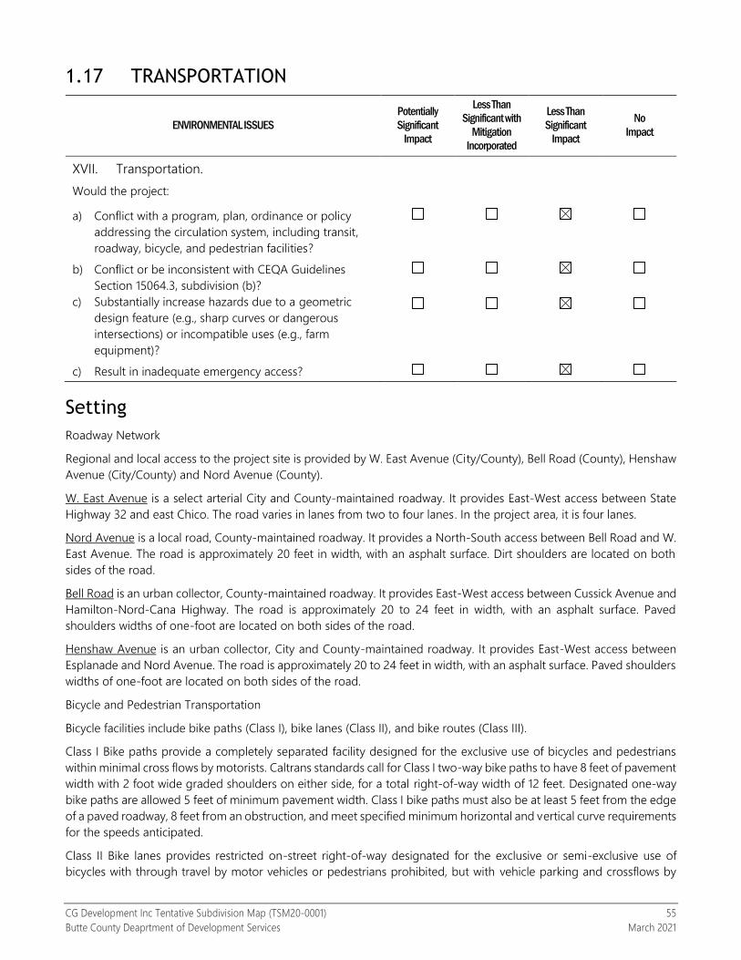
CG Development Inc Tentative Subdivision Map (TSM20-0001) 55
Butte County Deaprtment of Development Services March 2021
1.17 TRANSPORTATION
ENVIRONMENTAL ISSUES
Potentially
Significant
Impact
Less Than
Significant with
Mitigation
Incorporated
Less Than
Significant
Impact
No
Impact
XVII. Transportation.
Would the project:
a) Conflict with a program, plan, ordinance or policy
addressing the circulation system, including transit,
roadway, bicycle, and pedestrian facilities?
b) Conflict or be inconsistent with CEQA Guidelines
Section 15064.3, subdivision (b)?
c) Substantially increase hazards due to a geometric
design feature (e.g., sharp curves or dangerous
intersections) or incompatible uses (e.g., farm
equipment)?
c) Result in inadequate emergency access?
Setting
Roadway Network
Regional and local access to the project site is provided by W. East Avenue (City/County), Bell Road (County), Henshaw
Avenue (City/County) and Nord Avenue (County).
W. East Avenue is a select arterial City and County-maintained roadway. It provides East-West access between State
Highway 32 and east Chico. The road varies in lanes from two to four lanes. In the project area, it is four lanes.
Nord Avenue is a local road, County-maintained roadway. It provides a North-South access between Bell Road and W.
East Avenue. The road is approximately 20 feet in width, with an asphalt surface. Dirt shoulders are located on both
sides of the road.
Bell Road is an urban collector, County-maintained roadway. It provides East-West access between Cussick Avenue and
Hamilton-Nord-Cana Highway. The road is approximately 20 to 24 feet in width, with an asphalt surface. Paved
shoulders widths of one-foot are located on both sides of the road.
Henshaw Avenue is an urban collector, City and County-maintained roadway. It provides East-West access between
Esplanade and Nord Avenue. The road is approximately 20 to 24 feet in width, with an asphalt surface. Paved shoulders
widths of one-foot are located on both sides of the road.
Bicycle and Pedestrian Transportation
Bicycle facilities include bike paths (Class I), bike lanes (Class II), and bike routes (Class III).
Class I Bike paths provide a completely separated facility designed for the exclusive use of bicycles and pedestrians
within minimal cross flows by motorists. Caltrans standards call for Class I two-way bike paths to have 8 feet of pavement
width with 2 foot wide graded shoulders on either side, for a total right-of-way width of 12 feet. Designated one-way
bike paths are allowed 5 feet of minimum pavement width. Class I bike paths must also be at least 5 feet from the edge
of a paved roadway, 8 feet from an obstruction, and meet specified minimum horizontal and vertical curve requirements
for the speeds anticipated.
Class II Bike lanes provides restricted on-street right-of-way designated for the exclusive or semi-exclusive use of
bicycles with through travel by motor vehicles or pedestrians prohibited, but with vehicle parking and crossflows by

CG Development Inc Tentative Subdivision Map (TSM20-0001) 56
Butte County Deaprtment of Development Services March 2021
pedestrians and motorists permitted. Caltrans standards generally require a minimum 4-foot bike lane with 6-inch
white strip separating the roadway from the bike lane. Where raised curbs without permitted parking or designated
marked parking exists, a minimum 5-foot bike lane adjacent to the traffic lane is required. Where parking is permitted,
but unmarked, the 6-inch white stripe separating the traffic lane from the bike lane must be a minimum of 12 feet from
the raised curb.
Class III Bike routes provides a preferred shared route with motorists on the street, or to a more restricted extent, with
pedestrians on sidewalks where designated by signs or permanent markings. The main purpose of designated bike
routes is to provide continuity to the bikeway network by connecting discontinuous segments of Class I and II bikeways
and may also be used to direct bicyclists to a route of higher degree of service or use. Roadways designated as Class
III bike routes should have sufficient width to accommodate motorists, bicyclists, and pedestrians. Other than a street
sign, there are no special markings required for a Class III bike route.
Pedestrian facilities include sidewalks, crosswalks, pedestrian signals, and paved shoulders adjacent to rural roads. The
County of Butte’s Development Standards typically require proposed residential and commercial developments located
in the County’s urban areas to construct curb, gutter, and sidewalk improvements within the County roadways fronting
development. Residential developments located within the Chico Urban Area that have lot sizes greater than one acre
come under a separate rural standard that presently does not require curb, gutter, and sidewalks to be constructed.
Elsewhere sidewalks are presently constructed to County Public Works Standards with a four-foot wide sidewalk in
residential areas and a five-foot wide sidewalk within commercial areas (Butte County Bicycle Plan, 2011).
There are no designated pedestrian or bicycle transportation facilities located near the project site, nor are such facilities
proposed for the project area. Given the lack of existing facilities, pedestrian and bicycle traffic generally will use the
unpaved and paved roadway shoulders, or the paved travel lanes.
Discussion
a) Conflict with a program, plan, ordinance or policy addressing the circulation system, including transit, roadway, bicycle, and pedestrian facilities?
Less than significant impact. The project site is located in a very low-density residential area with no existing
transit, bicycle or pedestrian facilities located on, or in the vicinity of, the project site. The nearest transit line is
the Butte County Association of Governments B-Line Route 3, which runs on W. East Avenue with a stop on
the intersection of W. East Avenue and Nord Avenue and is approximately 0.8 milesfrom the project site. Future
development on the resultant parcels would have minor long-term impacts on alternative transportation
facilities due to the limited population growth to the project area. Construction activities associated with future
development may generate short-term disruption to area roadways from an anticipated increase in traffic
levels that may affect alternative transportation uses. However, construction activities associated with the
proposed project would be temporary, and would require traffic control implementation, if needed.
b) Conflict or be inconsistent with CEQA Guidelines Section 15064.3, subdivision (b)?
Less than significant impact. A vehicle miles travelled (VMT) impact analysis for was prepared for the CG
Development Tentative Subdivision Map project at Nord Avenue. The analysis and documentation have been
prepared consistent with Public Resources Code (PRC) 15064.3 and contains the following components.
Regulatory Setting
Environment Setting
Impact Analysis
Regulatory Setting
Regulations, laws, policies, and plans applicable to and/or considered for the VMT impact analysis for the
proposed project are described below.

CG Development Inc Tentative Subdivision Map (TSM20-0001) 57
Butte County Deaprtment of Development Services March 2021
Federal
No federal plans, policies, regulations, or laws related to transportation and circulation apply to the project.
State
The State of California has enacted several pieces of legislation that outline the state’s commitment to
encourage land use and transportation planning decisions and investments that reduce vehicle miles traveled
(VMT) and contribute to reductions in greenhouse gas (GHG) emissions in line with state climate goals.
Legislation that is potentially applicable to VMT impact analysis for the proposed project is listed below.
Assembly Bill (AB) 32 (2006)
Senate Bill (SB) 375 (2008)
SB 743 (2013)
Assembly Bill 32
AB 32 establishes regulatory, reporting, and market mechanisms to achieve quantifiable reductions in GHG
emissions and a cap on statewide GHG emissions. AB 32 requires that statewide GHG emissions be reduced
to 1990 levels by 2020. AB 32 also requires that “(a) the statewide GHG emissions limit shall remain in effect
unless otherwise amended or repealed; (b) it is the intent of the Legislature that the statewide GHG emissions
limit continues in existence and be used to maintain and continue reductions in emissions of GHGs beyond
2020; (c) the California Air Resources Board (ARB) shall make recommendations to the Governor and the
Legislature on how to continue reductions of GHG emissions beyond 2020.” AB 32 goals are the foundation
for the GHG and VMT reductions expected through subsequent legislation including SB 375 and SB 743.
Senate Bill 375
SB 375 requires metropolitan planning organizations (MPOs) to prepare a Sustainable Communities Strategy
(SCS) as part of their regional transportation plans (RTPs). The SCS demonstrates how the region will meet its
GHG reduction targets through integrated land use, housing and transportation planning. Specifically, the SCS
must identify a transportation network that is integrated with the forecasted development pattern for the plan
area and will reduce GHG emissions from automobiles and light trucks in accordance with targets set by the
ARB.
In 2017, the State Legislature passed SB 150, which requires ARB to prepare a report beginning in 2018 and
every four years thereafter analyzing the progress made by each MPO in meeting regional GHG emission
reduction targets.
Senate Bill 743
SB 743 created or encouraged several statewide changes to the evaluation of transportation and traffic impacts
under CEQA. First, it directed the Governor’s Office of Planning and Research (OPR) to amend the CEQA
Guidelines to establish new metrics for determining the significance of transportation impacts of projects within
transit priority areas (TPAs) and allowed OPR to extend use of the new metrics beyond TPAs. In the amended
CEQA Guidelines, OPR selected VMT as the preferred transportation impact metric and applied their discretion
to recommend its use statewide. The California Natural Resources Agency certified and adopted the amended
CEQA Guidelines in December 2018.
The amended CEQA Guidelines contain the following relevant expectations for VMT impact analysis.
“Generally, vehicle miles traveled is the most appropriate measure of transportation impacts.”
“…vehicle miles traveled refers to the amount and distance of automobile travel attributable to a
project.”
“Generally, projects within one-half mile of either an existing major transit stop or a stop along an
existing high quality transit corridor should be presumed to cause a less than significant transportation
impact.”
“Projects that decrease vehicle miles traveled in the project area compared to existing conditions
should be presumed to have a less than significant transportation impact.”

CG Development Inc Tentative Subdivision Map (TSM20-0001) 58
Butte County Deaprtment of Development Services March 2021
Second, SB 743 establishes that aesthetic and parking impacts of a residential, mixed-use residential, or
employment center projects on an infill site within a TPA shall not be considered significant impacts on the
environment.
Third, SB 743 added Section 21099 to the Public Resources Code, which states that automobile delay, as
described by level of service (LOS) or similar measures of vehicular capacity or traffic congestion, shall not be
considered a significant impact on the environment upon certification of the CEQA Guidelines by the California
Natural Resources Agency. Since the amended CEQA Guidelines were certified in December 2018, LOS or
similar measures of vehicular capacity or traffic congestion are not considered a significant impact on the
environment.
Lastly, SB 743 establishes a new CEQA exemption for a residential, mixed-use, and employment center project
a) within a TPA, b) consistent with a specific plan for which an EIR has been certified, and c) consistent with an
SCS. This exemption requires further review if the project or circumstances changes significantly.
To aid in SB 743 implementation, OPR released a Technical Advisory on Evaluating Transportation Impacts in
CEQA (Technical Advisory) in December 2018. The Technical Advisory provides advice and recommendations
to lead agencies on how to implement SB 743 changes. This includes technical recommendations regarding
the assessment of VMT, thresholds of significance, VMT mitigation measures, and screening thresholds for
certain land use projects. Lead agencies may consider and use these recommendations at their discretion.
Specific to residential projects and considering the land use context for Butte County and project area, the
Technical Advisory contains the following recommendations related to assessing VMT impacts.
Small projects—projects consistent with a SCS and local general plan that generate or attract fewer
than 110 vehicle trips per day may be presumed to have a less than significant impact.
Projects in low-VMT areas—residential projects that incorporate similar features (i.e., density, mix of
uses, transit accessibility) as existing development in areas with low VMT (i.e., already below the VMT
impact significance threshold) will tend to exhibit similarly low VMT and may be presumed to have a
less than significant impact.
The Technical Advisory also identifies recommended numeric VMT thresholds for residential projects in
unincorporated areas, as described below.
A proposed project generating residential VMT per capita higher than 15 percent below the existing
regional average may indicate a significant transportation impact.
Other relevant threshold information in the Technical Advisory are references to the 2017 Scoping Plan-
Identified VMT Reductions and Relationship to State Climate Goals, California Air Resources Board, January 2019.
This ARB analysis identifies the need to reduce average statewide per capita VMT but also provides evidence
that some VMT growth can occur without disrupting the state’s climate goals. ARB modeled a Cleaner
Technologies and Fuels (CTF) scenario that evaluated what level of additional deployment of cleaner vehicle
technologies and fuels combined with slower growth in VMT would be necessary to achieve a 40 percent
reduction in GHG emissions from 1990 levels by 2030 and 80 percent by 2050. This is the same scenario that
was used to support the OPR Technical Advisory threshold recommendation for a 15 percent reduction in
baseline VMT per capita. The scenario modeling showed that California has a VMT growth capacity of 6.5
percent by 2050 above a 2015-2018 baseline average. In other words, if VMT growth is limited to 6.5 percent
by 2050, the state can meet its climate goals. For Butte County, this equates to about 326,350 daily VMT in
2050.
California Department of Transportation
The California Department of Transportation (Caltrans) is responsible for planning, designing, constructing,
operating, and maintaining the State Highway System (SHS). With respect to VMT impact analysis, Caltrans has
published the Vehicle Miles Traveled-Focused Transportation Impact Study Guide (VMT-TISG), May 20, 2020.
This guide outlines how Caltrans will review land use projects with a focus on supporting state land use goals,
state planning priorities, and GHG emission reduction goals. The VMT-TISG emphasizes that VMT analysis is

CG Development Inc Tentative Subdivision Map (TSM20-0001) 59
Butte County Deaprtment of Development Services March 2021
Caltrans’ primary review focus, and references OPR’s Technical Advisory as a basis for the guidance in the TISG.
Notably, the VMT-TISG endorses the recommended thresholds in the Technical Advisory for land use projects.
Since Caltrans routinely comments on local land use projects and is also the owner and operator of the state
highway system, their endorsement of the OPR VMT thresholds creates a potential ‘state’ VMT threshold
especially when they function as a responsible agency in local development review and have direct authority
over a part of project approval such as an encroachment permit for access to the state highway system.
Regional and Local
BCAG RTP/SCS
The Butte County Association of Governments (BCAG) serves as the MPO for Butte County. As the MPO, the
most relevant responsibility of the agency related to VMT impact analysis for local land use projects is through
the development of the RTP/SCS. The RTP/SCS reflects the population and employment growth anticipated
by local governments and includes a financially constrained list of transportation improvement projects. As
noted above under the SB 375 discussion, the SCS has specific GHG reduction targets set by CARB. The RTP
also must demonstrate compliance with federal air quality conformity. Therefore, RTP/SCS performance is
influenced by VMT growth so new land use projects that are not consistent with the RTP/SCS may jeopardize
the air quality conformity for the county or the ability to achieve GHG reduction goals.
The most recent RTP/SCS was adopted on December 10, 2020 and complies with federal and state performance
requirements. The specific SCS performance is reported below.
Source: Page 4-2, Butte County 2020 Regional Transportation Plan/Sustainable Communities Strategy (2020-
2040), BCAG, December 10, 2020.
The RTP/SCS does not contain a specific VMT reduction goal but VMT per capita reductions did contribute to
the SCS performance. As documented in Table 4.9-1 of the 2020 RTP/SCS SEIR, total VMT generated in the
county was projected to increase from 4,705,417 under 2018 baseline conditions to 5,332,327 under 2040
conditions with the proposed plan. This represents a 13.3 percent increase although total VMT per capita was
projected to decline about 3.4 percent from 20.7 to 20.0 between 2018 baseline and 2040.1
Butte County General Plan 2030, October 26, 2010 (Amended November 6, 2012)
The general plan does not contain quantitative VMT reduction goals. However, multiple policies are supportive
of achieving VMT reduction through increasing vehicle occupancies, sharing rides, promoting transit and active
transportation, and supporting work-at-home programs.
CIR-P2.1 Carpooling shall be encouraged by providing additional carpool pickup and park-and-ride locations
near transit centers and at freeway interchanges.
CIR-P2.2 Trip reduction among County employees shall be encouraged. Specific measures to encourage trip
reduction could include providing subsidies, bicycle facilities, alternative work schedules, ridesharing,
telecommuting and work-at-home programs, employee education and preferential parking for
carpools/vanpools.
1 The VMT forecasts exclude trip lengths external to the county and total VMT includes commercial vehicles.

CG Development Inc Tentative Subdivision Map (TSM20-0001) 60
Butte County Deaprtment of Development Services March 2021
CIR-P2.3 Home occupations shall be encouraged through streamlined application processes that are
appropriate to the intensity and proposed uses of the home business.
CIR-P2.4 Employers shall be encouraged to provide transit subsidies, bicycle facilities, alternative work
schedules, ridesharing, telecommuting and work-at-home programs, employee education and preferential
parking for carpools/vanpools.
Despite the policy support, the daily VMT was projected to increase from 4,126,991 to 6,397,512 between 2006
and 2030 with the proposed plan. A 2012 general plan amendment increased the 2030 daily VMT by 1,511.
Butte County Climate Action Plan (CAP), Butte County, February 25, 2014
The Butte County CAP sets community GHG reduction targets for 2020 and 2040 compared to baseline 2006
levels but does not establish a specific VMT reduction goal. Under 2020 conditions, the CAP expected only
about 0.2 percent of GHG emissions reduction to come from transportation measures. Annual VMT was largely
expected to continue increasing from 464,302,660 in 2006 to 567,121,185 in 2020, and 677,283,969 in 2030
representing a total increase of 46 percent between 2006 and 2030.
Environmental Setting
This section discusses the environmental setting relevant to VMT impact analysis for the CG Development Nord
Avenue project. The project is located in an unincorporated area of Butte County close to the City of Chico
and proposes to construct 19 single-family residential units. To evaluate potential VMT impacts of the proposed
project, baseline VMT conditions were estimated based on a modified version of the BCAG RTP/SCS travel
demand model.
BCAG RTP/SCS Model The VMT impact analysis for the CG Development Nord Avenue project was prepared using modified version
1.1–3.17.21 of the BCAG RTP/SCS travel demand model. The model was recently updated as part of the 2020
BCAG RTP/SCS and continues to be refined through various on-going studies and project applications. The
BCAG model was developed for regional planning and analysis purposes associated with the RTP/SCS. The
model has a 2018 base year and forecast years of 2020 and 2040. The 2018 base year model represents pre-
Camp Fire conditions while the 2020 version represents post-Camp Fire conditions.
While the primary purpose of the model is to support the RTP/SCS analysis, the model was designed with
sufficient detail for local and project scale applications including VMT impact analysis. Prior to application for
this project, the model was reviewed and modified to improve its sensitivity for project-scale VMT analysis.
This included a review of the model’s VMT forecasts by traffic analysis zone (TAZ) and adjustments to account
for travel outside the model boundary.
More details about the model’s development and a user’s guide are available at the following BCAG website.
http://www.bcag.org/Planning/Transportation-Forecasting/index.html
Baseline VMT
For purposes of this VMT impact analysis, baseline conditions are represented by 2020 forecasts from the
modified BCAG RTP/SCS travel demand model. Baseline is normally defined as the analysis year when the
notice of preparation (NOP) is released or when environmental impact analysis is commenced. Therefore, the
year 2020 version of the model was the most reasonable choice for this study. It reflects conditions after the
Camp Fire and prior to COVID-19. As such, it represents, the best available data for estimating baseline VMT.
Figures 1 and 1A show the mapping of residential VMT generation for each TAZ in the County. Areas of
concentrated development such as those within incorporated cities and nearby, generate VMT at a lower rate
than the BCAG region average. This pattern can also be seen in more aggregate jurisdictional estimates of
VMT shown in Figure 2 below. In general, as separation between land uses increase so does VMT because
distances are longer between trip origins and destinations.

CG Development Inc Tentative Subdivision Map (TSM20-0001) 61
Butte County Deaprtment of Development Services March 2021
The green TAZs shown in Figures 1 and 1A generate residential VMT at rates below the OPR Technical Advisory
recommended threshold of 15 percent below the regional average. As such, these TAZs qualify as low VMT
areas under the OPR Technical Advisory. Per the Advisory discussion above, residential projects in these zones
may be presumed to have a less than significant VMT impact if they are expected to exhibit similarly low VMT
levels.

CG Development Inc Tentative Subdivision Map (TSM20-0001) 62
Butte County Deaprtment of Development Services March 2021

CG Development Inc Tentative Subdivision Map (TSM20-0001) 63
Butte County Deaprtment of Development Services March 2021

CG Development Inc Tentative Subdivision Map (TSM20-0001) 64
Butte County Deaprtment of Development Services March 2021
FIGURE 2: Home-based VMT per Resident by Jurisdiction
Source: Modified version 1.1-3.17.21 of the BCAG RTP/SCS model. Modifications to the model are still being refined so
these estimates and forecasts are expected to be updated including a new 2020 forecast year based on the results of the
Post Camp Fire Regional Population and Transportation Study (PCFS).
As shown in Figures 1 and 2, the specific VMT metric used in this study to evaluate VMT impacts is home-based
VMT per resident. This is a residential specific VMT metric and includes trips made by residents of the home
using passenger vehicles. The metric complies with methodology and metric recommendations contained in
the CEQA Guidelines and OPR Technical Advisory. This metric does not include commercial vehicle trips that
may be generated by the project’s residential units (i.e., internet shopping deliveries) and passenger vehicle
trips made by non-residents of the home (i.e., food deliveries). A visualization of the home-based VMT per
resident metric is provided below in Figure 3.
FIGURE 3: VMT Metric Definition and Visualization
Metric Definition Visualization
Home-based VMT
per resident
All automobile (i.e., passenger cars
and light-duty trucks) vehicle-trips
that start or end at the home are
traced, but non-home-based trips
made by residents elsewhere on
the network are excluded.

CG Development Inc Tentative Subdivision Map (TSM20-0001) 65
Butte County Deaprtment of Development Services March 2021
Butte County has not selected VMT impact significance thresholds for residential projects. The county is
participating in an SB 743 implementation study sponsored by BCAG to assess VMT impact analysis
methodology, thresholds, and mitigation options. This study is scheduled to be completed in June 2021. The
County intends to make final threshold decisions after completion of the BCAG study. Until that time, the CEQA
Guidelines and OPR Technical Advisory recommendations below are used to assess VMT impact significance
for this project. According to the OPR Technical Advisory, projects that meet either criterion below may be
presumed to have a less than significant VMT impact.
The proposed project would be presumed to have a less than significant VMT impact if generates less
than 110 vehicle trips per day.
The proposed project would be presumed to have a less than significant VMT impact if it generates home-
based VMT per resident at or less than 16.7, which is 15 percent below the BCAG region average home-based
VMT per resident in 2020.
Impact Analysis
The VMT impact analysis consisted of applying the screening thresholds above to the proposed project. The
first threshold required an estimate of the project’s total daily vehicle trips. Estimating vehicle trip generation
for the project depends on the specific trip generation methodology and rates. Two sources were consulted
for this evaluation including the Trip Generation Manual, 10th Edition, Institute of Transportation Engineers, 2017
and the BCAG RTP/SCS travel demand model. The ITE rates reflect data collected from around the U.S. and
are not calibrated and validated to Butte County. The BCAG RTP/SCS model relies on California household
travel survey (CHTS) data to estimate person trip rates that are converted to vehicle trips through the modeling
process. The data and model are calibrated and validated to local Butte County conditions.
The average ITE vehicle trip rate for single-family detached homes is 9.44 vehicle trips per unit while the BCAG
RTP/SCS model estimate for new single-family households in the specific project area is not projected to
exceed about 7.17 vehicle trips per unit. The BCAG RTP/SCS model estimate considers the local land use
context, mode choices available, distances to destinations along with household size (e.g., number of persons
per household) and income level. Nevertheless, using either vehicle trip rate would produce more than 110
daily vehicle trips, so the project is not considered a small project for VMT impact screening purposes.
To evaluate the second screening threshold, only the BCAG RTP/SCS model could be applied. The same
methodology used to establish the threshold (i.e., 15 percent below the BCAG region average home-based
VMT per resident in 2020), must be used for the project evaluation to ensure and apples-to-apples comparison.
Figure 1A showed the expected home-based VMT per resident for each TAZ in the Chico area compared to
the threshold above. The green TAZs all generate home-based VMT per resident below the threshold. As
shown below, the proposed project is entirely enclosed within one of the green TAZs. This information confirms
that the project qualifies for VMT impact screening because it is in a low VMT generating area and is similar to
existing land uses nearby.

CG Development Inc Tentative Subdivision Map (TSM20-0001) 66
Butte County Deaprtment of Development Services March 2021
A final impact factor that can be used to support the project’s screening is that the total home-based VMT of
the project is less than 250 per weekday. As noted in the setting, the VMT growth budget estimated for Butte
County based on ARB’s scoping plan analysis is about 326,350 per weekday in 2050. Therefore, the proposed
project does not jeopardize state plans for long-term VMT reduction.
The low VMT generation for the project area is largely due to the proximity to the City of Chico, which allows
for short trip lengths of about 2 miles to nearby shopping and less than 3 miles to major destinations like
California State University, Chico (see image below). B-Line Route 3 also runs nearby with stops at the
Nord/East intersection about 0.8 miles from the project site center with 30-minute headways during peak
periods. The combination of land use proximity and transportation evidence supports the presumption that
the project would have a less than significant VMT impact based on the impact analysis approach
recommended in the OPR Technical Advisory.
Project Location TAZ 221 = 12.2 home-based VMT per resident

CG Development Inc Tentative Subdivision Map (TSM20-0001) 67
Butte County Deaprtment of Development Services March 2021
Other Impact Analysis Evidence
When making a final VMT impact determination, other available evidence related to VMT trends should be
considered. This study identified the following two relevant studies.
2018 Progress Report, California’s Sustainable Communities and Climate Protection Act, California Air
Resources Board, November 2018 (referred to as the Progress Report in the remainder of this document).
California Air Resources Board Improved Program Measurement Would Help California Work More
Strategically to Meet Its Climate Change Goals, Auditor of the State of California, February 2021 (referred
to as the Audit Report in the remainder of this document).
The Progress Report measures the effect of SB 375 revealing that VMT and GHG per capita increased in
California between 2010 and 2016 and are trending upward (see Figure 4 below).

CG Development Inc Tentative Subdivision Map (TSM20-0001) 68
Butte County Deaprtment of Development Services March 2021
Figure 4: VMT/Capita Trends
The Audit Report is a more recent assessment of ARB’s GHG reduction programs, which also found that VMT
and its associated GHG emissions were trending upward through 2018. Per the audit, the state is not on
track to achieve 2030 GHG reduction goals, and emissions from transportation have not been declining.
The evidence from these two reports does not refute the project’s VMT impact finding but does suggest greater
action on the part of the state may be needed to achieve the state’s GHG reduction goals. The project
contributes to the basic objectives of SB 743 for local agencies such as adding development in a land use
efficient area where the short-trip lengths to destinations allows for more multi-modal choices and low VMT
generation. The monitoring of state performance indicates that the state may need to take further action to
discourage vehicle travel (i.e., increasing the cost of driving) while reducing the barriers or constraints that
prevent more efficient use of vehicles and greater use of transit, walking, and bicycling. If these types of actions
are taken, residents of the proposed project would have multiple travel options to further reduce their vehicle
use because of the proximity to existing destinations in Chico.
Analysis Limitations
This analysis was performed in March 2021 during the COVID-19 pandemic. The COVID-19 response has
dramatically changed human activities and associated travel patterns. Performing more activities from home
was already a trend due to the internet, but COVID-19 accelerated transitions to working and shopping from
home. In addition, other disruptive trends related to demographic changes, new travel choices such as Uber
and Lyft, and the potential for autonomous vehicle (AV) travel make predicting future travel demand and
outcomes less certain. Given these limitations of modeling and forecasting, the general consistency of the
project with the broader SB 743 objectives and the legislative intent of CEQA noted below may warrant greater
emphasis in the VMT impact assessment.
Public Resources Code 21001. ADDITIONAL LEGISLATIVE INTENT
The Legislature further finds and declares that it is the policy of the state to:
(d) Ensure that the long-term protection of the environment, consistent with the provision of a decent home and
suitable living environment for every Californian, shall be the guiding criterion in public decisions.

CG Development Inc Tentative Subdivision Map (TSM20-0001) 69
Butte County Deaprtment of Development Services March 2021
c) Substantially increase hazards due to a geometric design feature (e.g., sharp curves or dangerous intersections) or incompatible uses (e.g., farm equipment)?
Less than significant impact. The proposed project would not change the configuration (alignment) of area
roadways, and would not introduce types of vehicles that are not already traveling on area roads. The proposed
project includes a new roads (cul-de-sacs), one serving eight lots and one serving 10 lots. The project’s internal
roads (cul-de-sacs) will be offered for dedication to the County and will be maintained as part of a Permanent
Road Division (PRD). The project will also be required to improve the parcel frontage and part of Nord Avenue
along the parcel frontage. Future improvements would subject to review by Butte County Public Works. No
atypical road design features has been identified on the existing area roadways that would cause a safety
hazard.
d) Result in inadequate emergency access?
Less than significant impact. The proposed project will require improvements to Nord Avenue and two new cul-
de-sacs to City of Chico standards. Butte County Code 20-133 allows for a cul-de-sac length of 1,320 feet for parcels
zoned 1 to 5 acres. The cul-dac-sac lengths, as determined per BCC 20-133 are approximately 450 and 575 feet,
which are consistent with the cul-de-sac lengths. Future road and encroachment improvements would be reviewed
by the Butte County Public Works Department and Butte County Fire Protection Department/California
Department of Forestry and Fire Protection to ensure that any potential safety concerns are addressed.

CG Development Inc Tentative Subdivision Map (TSM20-0001) 70
Butte County Deaprtment of Development Services March 2021
1.18 TRIBAL CULTURAL RESOURCES
ENVIRONMENTAL ISSUES
Potentially
Significant
Impact
Less Than
Significant with
Mitigation
Incorporated
Less Than
Significant
Impact
No
Impact
XVIII. Tribal Cultural Resources.
Has a California Native American Tribe requested
consultation in accordance with Public Resources Code
section 21080.3.1(b)?
Yes No
Would the project cause a substantial adverse change in the significance of a tribal cultural resource, defined in
Public Resources Code section 21074 as either a site, feature, place, cultural landscape that is geographically
defined in terms of the size and scope of the landscape, sacred place, or object with cultural value to a California
Native American tribe, and that is:
a) Listed or eligible for listing in the California Register
of Historical Resources, or in a local register of
historical resources as defined in Public Resources
Code section 5020.1(k)?
b) A resource determined by the lead agency, in its
discretion and supported by substantial evidence, to
be significant pursuant to criteria set forth in
subdivision (c) of Public Resources Code Section
5024.1. In applying the criteria set forth in subdivision
(c) of Public Resource Code Section 5024.1, the lead
agency shall consider the significance of the
resource to a California Native American tribe?
Environmental Setting
Tribal Cultural Resources are defined as a site feature, place, cultural landscape, sacred place or object, which is of
cultural value to a Tribe and is either on or eligible for the California Historic Register, a local register, or a resource
that the lead agency, at its discretion, chooses to treat as such (Public Resources Code Section 21074 (a)(1)).
Butte County contains a rich diversity of archaeological, prehistoric and historical resources. The General Plan 2030 EIR
observes that the “archaeological sensitivity of Butte County is generally considered high, particularly in areas near
water sources or on terraces along water courses” (Butte County General Plan EIR, 2010, p. 4.5-7).
A substantial adverse change upon a historically significant resource would be one wherein the resource is demolished
or materially altered so that it no longer conveys its historic or cultural significance in such a way that justifies its
inclusion in the California Register of Historical Resources or such a local register (CEQA Guidelines Section 15064.5,
sub. (b)(2)). Cultural resources include prehistoric and historic period archaeological sites; historical features, such as
rock walls, water ditches and flumes, and cemeteries; and architectural features. Cultural resources consist of any
human-made site, object (i.e., artifact), or feature that defines and illuminates our past. Often such sites are found in
foothill areas, areas with high bluffs, rock outcroppings, areas overlooking deer migratory corridors, or near bodies of
water.
Per AB 52 Notification Request, Public Resources Code Section 21080.3(b), the County received two letters for
notification. One was from the Torres Martinez Cahuilla Indians, located in southern California near the Salton Sea, and
the other was from United Auburn Indian Community, located near the City of Auburn. It was determined through
discussion with the Torres Martinez Cahuilla Indians that they do not identify lands within Butte County within their

CG Development Inc Tentative Subdivision Map (TSM20-0001) 71
Butte County Deaprtment of Development Services March 2021
geographic area of traditional and cultural affiliation. The United Auburn Indian Community provided a map of their
area of traditional and cultural affiliation, which did not include the project site.
Discussion
Would the project cause a substantial adverse change in the significance of a tribal cultural resource, defined in Public Resources Code section 21074 as either a site, feature, place, cultural landscape that is geographically defined in terms of the size and scope of the landscape, sacred place, or object with cultural value to a California Native American tribe, and that is:
a) Listed or eligible for listing in the California Register of Historical Resources, or in a local register of historical resources as defined in Public Resources Code section 5020.1(k)?
Less than significant impact with mitigation incorporated. Per AB 52 Notification Request, Public Resources
Code Section 21080.3(b), the County received to letters for notification. One was from the Torres Martinez
Cahuilla Indians and the other was from United Auburn Indian Community (UAIC). It was determined that
discussion with the Torres Martinez Cahuilla Indians, they do not identify lands within Butte County within their
geographic area of traditional and cultural affiliation. The United Auburn Indian Community provided a map
of their area of traditional and cultural affiliation, which did not include the project site area.
b) A resource determined by the lead agency, in its discretion and supported by substantial evidence, to be significant pursuant to criteria set forth in subdivision (c) of Public Resources Code Section 5024.1. In applying the criteria set forth in subdivision (c) of Public Resource Code Section 5024.1, the lead agency shall consider the significance of the resource to a California Native American tribe?
Less than significant impact with mitigation incorporated. See discussion 4.17(a) – Tribal Cultural Resources.
Mitigation Measures
Refer to Mitigation Measure CUL-1

CG Development Inc Tentative Subdivision Map (TSM20-0001) 72
Butte County Deaprtment of Development Services March 2021
1.19 UTILITIES AND SERVICE SYSTEMS
ENVIRONMENTAL ISSUES
Potentially
Significant
Impact
Less Than
Significant with
Mitigation
Incorporated
Less Than
Significant
Impact
No
Impact
XIX. Utilities and Service Systems.
Would the project:
a) Require or result in the relocation or construction of
new or expanded water, wastewater treatment or
stormwater drainage, electric power, natural gas, or
telecommunication facilities, the construction or
relocation of which could cause significant
environmental effects?
b) Have sufficient water supplies available to serve the
project and reasonably foreseeable future
development during normal, dry and multiple dry
years?
c) Result in a determination by the wastewater
treatment provider that serves or may serve the
project that it has adequate capacity to serve the
project’s projected demand, in addition to the
provider’s existing commitments?
d) Generate solid waste in excess of State or local
standards, or in excess of the capacity of local
infrastructure, or otherwise impair the attainment of
solid waste reduction goals?
e) Comply with federal, state, and local management
and reduction statutes and regulations related to
solid waste?
Environmental Setting
Solid Waste
Most municipal wastes are hauled to the Neal Road Recycling and Waste Facility, which is owned by Butte County and
managed by the Butte County Department of Public Works. The Neal Road Facility is located at 1023 Neal Road, one
mile east from State Highway 99, and seven miles southeast of Chico, on 190 acres owned by Butte County. The Neal
Road Facility is permitted to accept municipal solid waste, inert industrial waste, demolition materials, special wastes
containing nonfriable asbestos, and septage. Hazardous wastes, including friable asbestos, are not accepted at the
Neal Road Facility or any other Butte County disposal facility, and must be transported to a Class I landfill permitted to
receive untreated hazardous waste. The Facility has a design capacity of 25,271,900 cubic yards, and is permitted to
accept 1,500 tons per day; however, the average daily disposal into the landfill is approximately 466 tons. As of
November 2017, the remaining capacity of the Neal Road Facility is approximately 15,449,172 cubic yards, which would
give the landfill a service life to the year 2048 (Neal Road Recycling & Waste Facility, 2017).

CG Development Inc Tentative Subdivision Map (TSM20-0001) 73
Butte County Deaprtment of Development Services March 2021
Discussion
a) Require or result in the relocation or construction of construction of new or expanded water, wastewater treatment or stormwater drainage, electric power, natural gas, or telecommunication facilities, the construction or relocation of which could cause significant environmental effects?
Less than significant impact.
The project development will be served by individual wells and wastewater systems. The Butte County
Environmental Health Division has performed a preliminary review of the proposed project, and has indicated
that future placement of an on-site septic system for the proposed parcel would be possible. At the time of
development, the proposed development would be evaluated for, and compliance with, wastewater disposal
standards would be insured. Therefore, the project would not have an impact on any wastewater treatment
facilities because septic systems would be utilized.
No existing on-site storm water drainage facilities are located on the project site. The applicant is proposing
to use underground stormwater leach trenches to retain stormwater runoff onsite. These retention facilities are
not anticipated to have any significant negative effects on the environment.
b) Have sufficient water supplies available to serve the project and reasonably foreseeable future development during normal, dry and multiple dry years?
Less than significant impact. Domestic water to existing and planned uses on the resultant parcels would be
provided by groundwater extraction via individual wells. Section 12.0 of the Butte County Improvement
Standards outline the requirements of water supplies for proposed subdivisions and parcel maps. Proposed
land divisions located outside an urban area and more than a 1,000 feet from an existing public water system,
may have its domestic water supplied by individual wells. The quantity and quality of the groundwater for the
proposed development is reviewed by the Butte County Environmental Health Division by either a test well, a
review of existing wells in the area, or a statement from a licensed well driller together with a report by an
engineering geologist or hydrologist verifying that minimum well production for domestic purposes are
achieved. Additionally, a well permit is required by the County to ensure well drilling standards are achieved
and health and safety standards are met. Well production from new wells would be tested to determine if
sufficient output it available for the anticipated uses to occur on the resultant parcels. Based on these reviews,
existing groundwater supplies are anticipated to be available to the serve the proposed project, and no
additional or expanded entitlements are required for groundwater extraction and use.
c) Result in a determination by the wastewater treatment provider that serves or may serve the project that it has adequate capacity to serve the project’s projected demand, in addition to the provider’s existing commitments?
No impact. Wastewater disposal for the proposed project would be provided by private, on-site septic systems.
The Butte County Environmental Health Division has performed a preliminary review of the proposed project,
and has indicated that future placement of an on-site septic system for the proposed parcel would be possible.
At the time of development, the proposed development would be evaluated, and compliance with wastewater
disposal standards would be insured. Therefore, the project would not have an impact on any wastewater
treatment facilities because septic systems would be utilized.
d) Generate solid waste in excess of State or local standards, or in excess of the capacity of local infrastructure, or otherwise impair the attainment of solid waste reduction goals?
Less than significant impact. Future development of the resultant parcels would result in a minor increase in
the stream of waste being deposited in the Neal Road Landfill. The California Integrated Waste Management

CG Development Inc Tentative Subdivision Map (TSM20-0001) 74
Butte County Deaprtment of Development Services March 2021
Board estimates that a typical residential household generate 10 to 12 pounds of waste per day (1.8 to 2.2 tons
per year). According to the Butte County Public Works Department, the Neal Road Landfill is expected to reach
maximum holding capacity by the year 2018, and is currently seeking a permit to expand the landfill so that it
can accommodate solid waste to the year 2034
e) Comply with federal, state, and local management and reduction statutes and regulations related to solid waste?
No impact. Based on the information discussed in 1.19 d) above, and because the proposed project would
comply with all applicable federal, state, and local statutes and regulations as they relate to solid waste,
adequate permitted landfill capacity exists to accommodate the proposed project.

CG Development Inc Tentative Subdivision Map (TSM20-0001) 75
Butte County Deaprtment of Development Services March 2021
1.20 WILDFIRE
ENVIRONMENTAL ISSUES
Potentially
Significant
Impact
Less Than
Significant with
Mitigation
Incorporated
Less Than
Significant
Impact
No
Impact
XX. Wildfire.
Is the project located in or near state responsibility areas
or lands classified as high fire hazard severity zones?
If located in or near state responsibility areas or lands
classified as very high fire hazard severity zones, would
the project:
Yes No
a) Substantially impair an adopted emergency response
plan or emergency evacuation plan?
b) Due to slope, prevailing winds, and other factors,
exacerbate wildfire risks, and thereby expose project
occupants to pollutant concentrations from a wildfire
or the uncontrolled spread of a wildfire?
c) Require the installation of associated infrastructure
(such as roads, fuel breaks, emergency water
sources, power lines or other utilities) that may
exacerbate fire risk or that may result in temporary
or ongoing impacts to the environment?
d) Expose people or structures to significant risks,
including downslope or downstream flooding or
landslides, as a result of runoff, post-fire slope
instability, or drainage changes?
Environmental Setting
The project site is within a Local Responsibility Area (LRA), which means that the Butte Fire/Cal Fire has responsibility
for preventing and suppressing fires. The project site is not near a State Responsibility Area (SRA) or areas designated
as a high fire hazard severity zone. The nearest Butte County fire station (Cal Fire/Butte County Fire #42) is located at
10 Frontier Circle, north of the project site, with an actual driving distance of approximately 3.8 miles. The nearest fire
station (City of Chico #6) is located approximately 1 mile to the south.
Discussion
a) Substantially impair an adopted emergency response plan or emergency evacuation plan?
No impact. There would be no lane closures involved in the proposed project that would constrict emergency
access or interfere with an emergency evacuation plan.
b) Due to slope, prevailing winds, and other factors, exacerbate wildfire risks, and thereby expose project occupants to pollutant concentrations from a wildfire or the uncontrolled spread of a wildfire?
No impact. The project site is not located in an area that is susceptible to wildland fires. No conditions or
factors have been identified in the project area that would exacerbate wildfire risks.

CG Development Inc Tentative Subdivision Map (TSM20-0001) 76
Butte County Deaprtment of Development Services March 2021
c) Require the installation of associated infrastructure (such as roads, fuel breaks, emergency water sources, power lines or other utilities) that may exacerbate fire risk or that may result in temporary or ongoing impacts to the environment?
Less than significant impact. The proposed project includes a new cul-de-sac that will serve the eight lots. The
new road will not create a fire risk or result in significant temporary or ongoing impacts to the environment.
d) Expose people or structures to significant risks, including downslope or downstream flooding or landslides, as a result of runoff, post-fire slope instability, or drainage changes?
No impact. The project site is located within a mix of residential and small agricultural uses (orchards) in the
valley region of the County that contain slopes between 0 and 2 percent. The project area does not exhibit
flooding potential (see discussion Section 1.10.d – Hydrology and Water Quality) or landslide potential (see
discussion Section 1.7.a – Geology Soils). Therefore, no impacts from post-fire instability or drainage changes
has been identified.
CG Development Inc Tentative Subdivision Map (TSM20-0001) 77
Butte County Deaprtment of Development Services March 2021
1.21 MANDATORY FINDINGS OF SIGNIFICANCE
ENVIRONMENTAL ISSUES
Potentially
Significant
Impact
Less Than
Significant with
Mitigation
Incorporated
Less Than
Significant
Impact
No
Impact
XX. Mandatory Findings of Significance.
a) Does the project have the potential to substantially
degrade the quality of the environment, substantially
reduce the habitat of a fish or wildlife species, cause
a fish or wildlife population to drop below self-
sustaining levels, threaten to eliminate a plant or
animal community, substantially reduce the number
or restrict the range of an endangered, rare, or
threatened species, or eliminate important examples
of the major periods of California history or
prehistory?
b) Does the project have impacts that are individually
limited, but cumulatively considerable?
(“Cumulatively considerable” means that the
incremental effects of a project are considerable
when viewed in connection with the effects of past
projects, the effects of other current projects, and
the effects of probable future projects.)
c) Does the project have environmental effects that will
cause substantial adverse effects on human beings,
either directly or indirectly?
Discussion
a) Does the project have the potential to substantially degrade the quality of the environment, substantially reduce the habitat of a fish or wildlife species, cause a fish or wildlife population to drop below self-sustaining levels, threaten to eliminate a plant or animal community, substantially reduce the number or restrict the range of an endangered, rare, or threatened species, or eliminate important examples of the major periods of California history or prehistory?
Less than significant impact. The proposed project’s impacts to biological resources and cultural resources
were analyzed in this Initial Study, and all direct, indirect, and cumulative impacts were determined to have no
impact, a less than significant impact, or reduced to a less than significant impact with implementation of
mitigation. No special status species were identified on the proposed development areas. Development of the
proposed project would not cause fish or wildlife populations to drop below self-sustaining levels or restrict
the movement/distribution of a rare or endangered species.
Development of the proposed project would not affect known historic, archaeological, or paleontological
resources. There are no known unique ethnic or cultural values associated with the project site, nor are known
religious or sacred uses associated with the project site. Mitigation Measure CUL-1 has been identified to
confirm the presence or absence of subsurface cultural resources on the project site. Additionally, the project
applicant is required to comply with California Code of Regulations (CCR) Section 15064.5(e), California Health
and Safety Code Section 7050.5, and Public Resources Code (PRC) Section 5097.98 as a matter of policy in the

CG Development Inc Tentative Subdivision Map (TSM20-0001) 78
Butte County Deaprtment of Development Services March 2021
event human remains are encountered at any time. Adherence to Mitigation Measures CUL-1, as well as
regulations governing human remains, would reduce potential impacts to cultural and paleontological
resources to less than significant with implementation of mitigation.
b) Does the project have impacts that are individually limited, but cumulatively considerable? (“Cumulatively considerable” means that the incremental effects of a project are considerable when viewed in connection with the effects of past projects, the effects of other current projects, and the effects of probable future projects.)
Less than significant impact with mitigation incorporated. The proposed project has either no impact, a less
than significant impact, or a less than significant impact with mitigation incorporated with respect to all
environmental issues pursuant to CEQA. Due to the limited scope of direct physical impacts to the environment
associated with the proposed project, the project’s impacts are primarily project-specific in nature.
This project has the potential to contribute impacts that are individually limited, but cumulatively considerable
with respect to Air Quality, Cultural Resources and Greenhouse Gas Emissions. Cumulative impacts to these
areas would be mitigated due to the inclusion of Mitigation Measure AIR-1, Mitigation Measure CUL-1 and
Mitigation Measure GHG-1.
Past, current, and probable future projects in the vicinity of the project site were reviewed to determine if any
additional cumulative impacts may occur with the approval of this project. A two-mile radius was used in
determining cumulative impacts. There are other land division projects in the Bell-Muir area that would add to
the cumulative impacts. Each project will be analyzed and include mitigations that will reduce their impacts to
a less than significant impact.
The cumulative effects resulting from build out of the Butte County General Plan 2030 were previously
identified in the General Plan EIR. The type, scale, and location of the proposed project is consistent with
County’s General Plan and zoning designation and is compatible with the pattern of development on adjacent
properties. Because of this consistency, the potential cumulative environmental effects of the proposed project
would fall within the impacts identified in the County’s General Plan EIR. Build-out of the resultant parcels is
subject to required “fair share” development impact fees, which will be paid at the time of development.
c) Does the project have environmental effects that will cause substantial adverse effects on human beings, either directly or indirectly?
Less than significant impact with mitigation incorporated. There have been no impacts discovered through the
review of this application demonstrating that there would be substantial adverse effects on human beings
either directly or indirectly. However, the proposed project has the potential to cause both temporary and
future impacts to the area by project-related impacts relating to air quality, cultural resources and greenhouse
gas emissions. With implementation of mitigation measures included in this Initial Study, these impacts would
be effectively mitigated to a less than significant level.
Authority for the Environmental Checklist: Public Resources Code Sections 21083, 21083.5.
Reference: Government Code Sections 65088.4.
Public Resources Code Sections 21080, 21083.5, 21095; Eureka Citizens for Responsible Govt. v. City of Eureka (2007)
147 Cal.App.4th 357; Protect the Historic Amador Waterways v. Amador Water Agency (2004) 116 Cal.App.4th at 1109;
San Franciscans Upholding the Downtown Plan v. City and County of San Francisco (2002) 102 Cal.App.4th 656.

CG Development Inc Tentative Subdivision Map (TSM20-0001) 79
Butte County Deaprtment of Development Services March 2021
Environmental Reference Materials
1. Butte County. Butte County Climate Action Plan. February 25, 2014. Available at http://www.buttecap.net/
2. Butte County. Butte County General Plan 2030 Final Environmental Impact Report. April 8, 2010. Available at
http://www.buttegeneralplan.net/products/2010-08-30_FEIR/default.asp.
3. Butte County. Butte County General Plan 2030. October 26, 2010. Available at
http://www.buttecounty.net/dds/Planning/GeneralPlan/Chapters.aspx
4. Butte County. Butte County General Plan 2030 and Zoning Ordinance Amendments – Draft Supplemental
Environmental Impact Report. June 17, 2015. Available at http://www.buttegeneralplan.net/products/2012-05-
31_GPA_ZO_SEIR/default.asp
5. Butte County. Butte County General Plan 2030 Setting and Trends Report Public Draft. August 2, 2007. Available at
http://www.buttegeneralplan.net/products/SettingandTrends/default.asp.
6. Butte County. Butte County Code of Ordinances, Chapters 19, 20, 24 & 41A. Available at
https://www.municode.com/library/ca/butte_county/codes/code_of_ordinances/
7. Butte County. Butte County Department of Development Services GIS Data. October 2020.
8. Butte County Air Quality Management District. CEQA Air Quality Handbook – Guidelines for Assessing Air Quality
and Greenhouse Gas Impacts for Projects Subject to CEQA Review. October 23, 2014. Available at
https://bcaqmd.org/planning/air-quality-planning-ceqa-and-climate-change/
9. Butte County Public Works Department, Division of Waste Management. Joint Technical Document-Neal Road
Recycling and Waste Facility, Butte County, California. November 2017.
10. California Department of Conservation. Fault-Rupture Hazard Zones in California. Altquist-Priolo Earthquake Fault
Zoning Act with Index to Earthquake Fault Zone Maps. Special Publication 42. Interim Revision. 2007.
11. California Department of Conservation, Division of Land Resource Protection. A Guide to the Farmland Mapping
and Monitoring Program. 2014.
12. California Natural Diversity Database RareFind 5. September 2020.
13. California Department of Toxic Substance Control. 2009. Envirostor Database. Accessed in October 2020.
http://www.envirostor.dtsc.ca.gov/public.
14. California Department of Finance. Population and Housing Estimates for Cities, Counties, and the State, 2011-2018.
March 5, 2019.
15. California Department of Water Resources, Northern Region Office. Geology of the Northern Sacramento Valley,
California. September 2014.
16. California Department of Finance. Population and Housing Estimates for Cities, Counties, and the State, 2011-2018.

Mitigation Measures and Monitoring Requirements
CG Development Inc Tentative Subdivision Map (TSM20-0001)
Mitigation Measure AIR-1
The following best practice measures to reduce impacts to air quality shall be incorporated by the project
applicant. subject property owners, or third-party contractors during construction activities on the project site.
These measures are intended to reduce criteria air pollutants that may originate from the site during the course
of land clearing and other construction operations. Place a note on a separate document which is to be
recorded concurrently with the map or on an additional map sheet that states: "Dust generated by the
development activities shall be kept to a minimum and retained on-site. Follow the air quality control measures
listed below:
Diesel PM Exhaust from Construction Equipment and Commercial On-Road Vehicles Greater than 10,000
Pounds • All on- and off-road equipment shall not idle for more than five minutes. Signs shall be posted in the
designated queuing areas and/or job sites to remind drivers and operators of the five-minute idling
limit.• Idling, staging and queuing of diesel equipment within 1,000 feet of sensitive receptors is prohibited.• All construction equipment shall be maintained in proper tune according to the manufacturer's
specifications. Equipment must be checked by a certified mechanic and determined to be running in
proper condition before the start of work.• Install diesel particulate filters or implement other (ARB-verified diesel emission control strategies.• Shall not operate a diesel-fueled auxiliary power system (APS) to power a heater, air conditioner, or
any ancillary equipment on that vehicle during sleeping or resting in a sleeper berth for greater than
5 minutes at any location when within 100 feet of a restricted areas.• To the extent feasible, truck trips shall be scheduled during non-peak hours to reduce perk hour
emissions.
Operational TAC Emissions • All mobile and stationary Toxic Air Contaminants (TACs) sources shall comply with applicable Airborne
Toxic Control Measures (ATCMs) promulgated by the CARB throughout the life of the project (see
http:www.arb.ca.gov/toxics/atcm/atcm.htm).
• Stationary sources shall comply with applicable District rules and regulations.
Fugitive Dust
Construction activities can generate fugitive dust that can be a nuisance to local residents and businesses near
a construction site. Dust complaints could result in a violation of the District's "Nuisance" and "Fugitive Dust"
Rules 200 and 205, respectively. The following is a list of measures that may be required throughout the
duration of the construction activities: • Reduce the amount of the disturbed area where possible.• Use of water trucks or sprinkler systems in sufficient quantities to prevent airborne dust from leaving
the site. An adequate water supply source must be identified. Increased watering frequency would be
required whenever wind speeds exceed 15 mph. Reclaimed (non-potable) water should be used
whenever possible.• All dirt stockpile areas should be sprayed daily as needed, covered, or a District approved alternative
method will be used.• Permanent dust control measures identified in the approved project revegetation and landscape plans
should be implemented as soon as possible following completion of any soil disturbing activities.
Butte County Department of Development Services - Planning Division 7 County Center Drive
Oroville, CA 95928
530.552.3700

Mitigation Measures and Monitoring Requirements
CG Development Inc Tentative Subdivision Map (TSM20-0001)
• Exposed ground areas that will be reworked at dates greater than one month after initial grading
should be sown with a fast-germinating non-invasive grass seed and watered until vegetation is
established.• All disturbed soil areas not subject to re-vegetation should be stabilized using approved chemical soil
binders, jute netting, or other methods approved in advance by the Butte County Air Quality
Management District.• All roadways, driveways, sidewalks, etc. to be paved should be completed as soon as possible. In
addition, building pads should be laid as soon as possible after grading unless seeding or soil binders
are used.• Vehicle speed for all construction vehicles shall not exceed 15 mph on any unpaved surface at the
construction site.• All trucks hauling dirt, sand, soil, or other loose materials are to be covered or should maintain at least
two feet of freeboard (minimum vertical distance between top of load and top of trailer) in accordance
with local regulations.• Install wheel washers where vehicles enter and exit unpaved roads onto streets, or wash off trucks and
equipment leaving the site.• Sweep streets at the end of each day if visible soil material is carried onto adjacent paved roads. Water
sweepers with reclaimed water should be used where feasible.• Post a sign in prominent location visible to the public with the telephone numbers of the contractor
and the Butte County Air Quality Management District - (530) 332-9400 for any questions or concerns
about dust from the project."
All fugitive dust mitigation measures required should be shown on grading and building plans. In addition, the
contractor or builder should designate a person or persons to monitor the dust control program and to order
increased watering, as necessary, to prevent transport of dust offsite. Their duties shall include holidays and
weekend period when work may not be in progress. The name and telephone number of such persons shall
be provided to the District prior to land use clearance for map recordation and finished grading of the area.
Please note that violations of District Regulations are enforceable under the provisions of California Health and
Safety Code Section 42400, which provides for civil or criminal penalties of up to $25,000 per violation.
Plan Requirements: The note shall be placed on a separate document which is to be recorded concurrently
with the map or on an additional map sheet. This note shall also be placed on all building and site development
plans.
Timing: Requirements of the condition shall be adhered to throughout all grading and construction periods.
Monitoring: The Butte County Department of Development Services and the Public Works Department shall
ensure that the note is placed on a separate document which is to be recorded concurrently with the map or
on an additional map sheet. Building inspectors shall spot check and shall ensure compliance on-site. Butte County Air Pollution Control District inspectors shall respond to nuisance complaints.
Butte County Department of Development Services - Planning Division
7 County Center Drive
Oroville, CA 95928
530.552.3700

Mitigation Measures and Monitoring Requirements
CG Development Inc Tentative Subdivision Map (TSM20-0001)
Mitigation Measure CUL-1
Place a note on a separate document which is to be recorded concurrently with the map or on an additional
map sheet that states: "If grading activities reveal the presence of prehistoric or historic cultural resources (i.e.,
artifact concentrations, including arrowheads and other stone tools or chipping debris, cans glass, etc.;
structural remains; human skeletal remains) work within 50 feet of the find shall immediately cease until a
qualified professional archaeologist can be consulted to evaluate the find and implement appropriate
mitigation procedures. If human skeletal remains are encountered, State law requires immediate notification
of the County Coroner (530.538.7404). If the County Coroner determines that the remains are in an
archaeological context, the Native American Heritage Commission in Sacramento shall be notified immediately,
pursuant to State Law, to arrange for Native American participation in determining the disposition of such
remains." The provisions of this mitigation shall be followed during construction of all subdivision
improvements, including land clearing, road construction, utility installation, and building site development.
Plan Requirements: This note shall be placed on a separate document which is to be recorded concurrently
with the map or on an additional map sheet and shall be shown on all site development and building plans.
Timing: This measure shall be implemented during all site preparation and construction activities.
Monitoring: The Department of Development Services and/or Public Works Department shall ensure the note
is placed on a separate document which is to be recorded concurrently with the map or on an additional map
sheet. Should cultural resources be discovered, the landowner shall notify the Planning Division and a
professional archaeologist. The Planning Division shall coordinate with the developer and appropriate
authorities to avoid damage to cultural resources and determine appropriate action. State law requires the
reporting of any human remains.
Mitigation Measure GHG-1
Place a note on a separate document which is to be recorded concurrently with the map or on an additional
map sheet that states: "To the extent feasible, the project proponent shall implement the following measures
during construction-related activities and at the time of development to offset the anticipated contribution of
greenhouse gas emissions:
• Support expansion of renewable energy systems
o Prewire all new residential development to support photovoltaic system installation.
• Support efficiency in vehicles and landscaping equipment
o Install electrical vehicle outlets on external walls or in garages in all new residential
development.
• Improve fuel efficiency of equipment during construction-related activities
o Minimize idling time either by shutting equipment off when not in use or reducing the time
of idling to no more than 3 minute.
o Use clean or alternative fuel equipment"
Plan Requirements: The note shall be placed on a separate document which is to be recorded concurrently
with the map or on an additional map sheet. This note shall also be placed on all building and site development
plans.
Timing: Shall be implemented prior to issuance of building permits for residential development. Construction
related measures shall be adhered to throughout all grading and construction periods.
Butte County Department of Development Services - Planning Division
7 County Center Drive
Oroville, CA 95928
530.552.3700

Mitigation Measures and Monitoring Requirements
CG Development Inc Tentative Subdivision Map (TSM20-0001)
Monitoring: The Butte County Department of Development Services and the Public Works Department shall
ensure that the note is placed on a separate document which is to be recorded concurrently with the map or
on an additional map sheet. Planning Division will ensure that future residential development includes the
applicable measures during Building Permit review. Building inspectors shall spot check and shall ensure
compliance on-site.
Project Sponsor(s) Incorporation of Mitigation into Proposed Project
I/We have reviewed the Initial Study for the CG Development Inc Tentative Subdivision Map (TSM20-0001)
application and particularly the mitigation measures identified herein. I/We hereby modify the applications on
file with the Butte County Planning Department to include and incorporate all mitigations set forth in this Initial
Study.
C c:: 116/v Date
->
Project Sponsor/Project Agent
Project Sponsor/Project Agent Date
Butte County Department of Development Services - Planning Division
7 County Center Drive
Oroville, CA 95928
530.552.3700