Embed Size (px)
Citation preview
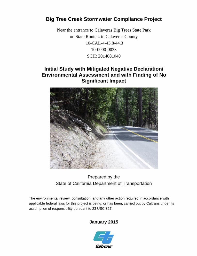
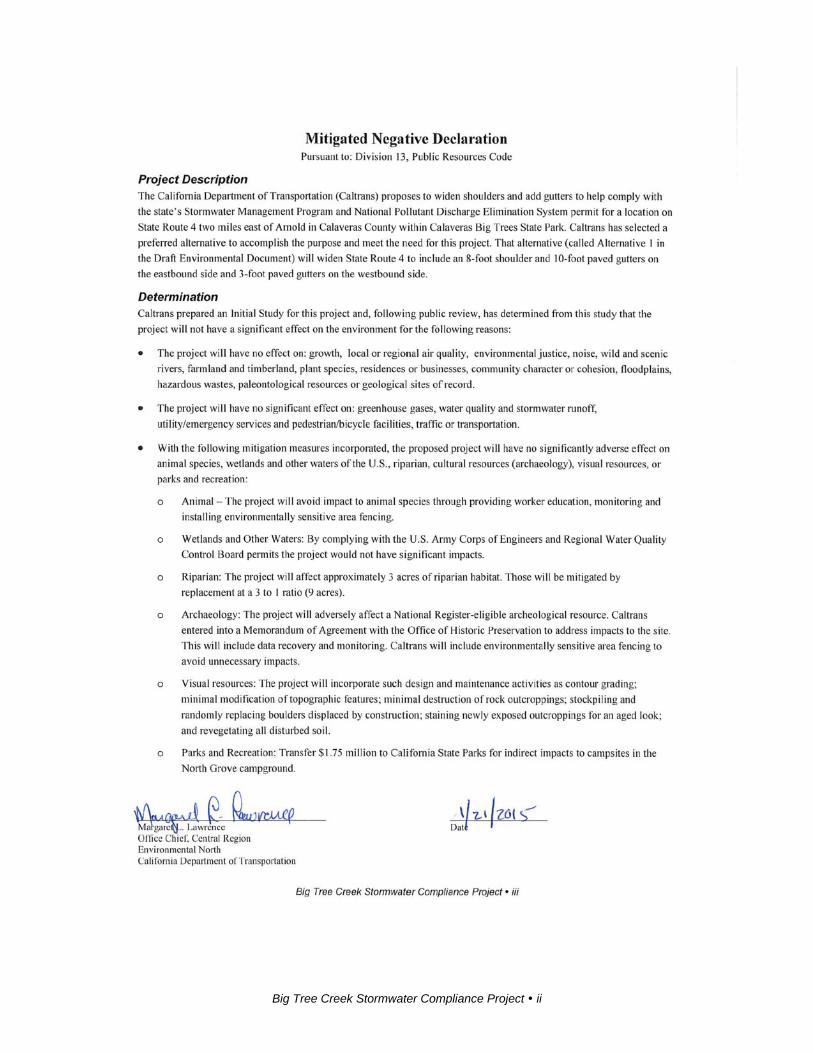
Big Tree Creek Stormwater Compliance Project
Near the entrance to Calaveras Big Trees State Park
on State Route 4 in Calaveras County
10-CAL-4-43.8/44.3
10-0000-0033
SCH: 2014081040
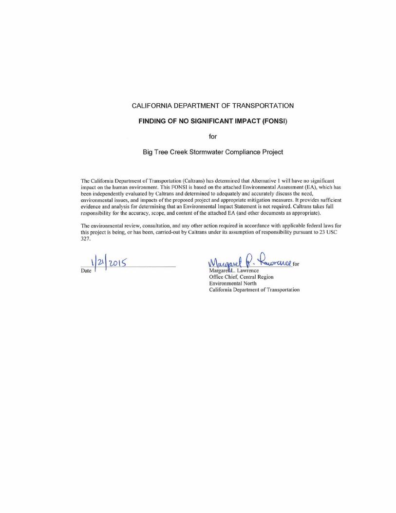
Initial Study with Mitigated Negative Declaration/
Environmental Assessment and with Finding of No Significant Impact
Prepared by the
State of California Department of Transportation
The environmental review, consultation, and any other action required in accordance with
applicable federal laws for this project is being, or has been, carried out by Caltrans under its
assumption of responsibility pursuant to 23 USC 327.
January 2015

General Information About This Document
What’s in this document: For individuals with sensory disabilities, this document can be made available in Braille, in large print,
on audiocassette, or on computer disk. To obtain a copy in one of these alternate formats, please call or
write to the Department of Transportation, Attn: Scott Smith, Central Region Environmental, 855 M
Street, Suite 200, Fresno, CA 93721; (559) 445-6172 (Voice), or use the California Relay Service
1 (800) 735-2929 (TTY), 1 (800) 735-2929 (Voice) or 711.

Big Tree Creek Stormwater Compliance Project i
Big Tree Creek Stormwater Compliance Project ii
Big Tree Creek Stormwater Compliance Project iv
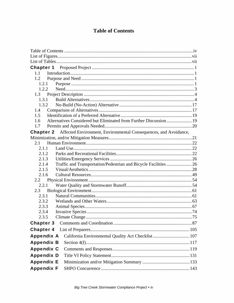
Table of Contents
Table of Contents ................................................................................................................ iv List of Figures ..................................................................................................................... vii List of Tables ...................................................................................................................... vii Chapter 1 Proposed Project ......................................................................................... 1
1.1 Introduction ............................................................................................................ 1 1.2 Purpose and Need .................................................................................................. 1
1.2.1 Purpose ........................................................................................................... 1 1.2.2 Need ................................................................................................................ 3
1.3 Project Description ................................................................................................ 4 1.3.1 Build Alternatives ........................................................................................... 4 1.3.2 No-Build (No-Action) Alternative ............................................................... 17
1.4 Comparison of Alternatives ................................................................................. 17 1.5 Identification of a Preferred Alternative .............................................................. 19 1.6 Alternatives Considered but Eliminated from Further Discussion ...................... 19 1.7 Permits and Approvals Needed ............................................................................ 20
Chapter 2 Affected Environment, Environmental Consequences, and Avoidance, Minimization, and/or Mitigation Measures ........................................................................ 21
2.1 Human Environment ............................................................................................ 22 2.1.1 Land Use ....................................................................................................... 22 2.1.2 Parks and Recreational Facilities .................................................................. 22 2.1.3 Utilities/Emergency Services ....................................................................... 26 2.1.4 Traffic and Transportation/Pedestrian and Bicycle Facilities ...................... 26 2.1.5 Visual/Aesthetics .......................................................................................... 28 2.1.6 Cultural Resources ........................................................................................ 49
2.2 Physical Environment .......................................................................................... 54 2.2.1 Water Quality and Stormwater Runoff ......................................................... 54
2.3 Biological Environment ....................................................................................... 61 2.3.1 Natural Communities .................................................................................... 61 2.3.2 Wetlands and Other Waters .......................................................................... 63 2.3.3 Animal Species ............................................................................................. 67 2.3.4 Invasive Species ........................................................................................... 74 2.3.5 Climate Change ............................................................................................ 75
Chapter 3 Comments and Coordination .................................................................... 87
Chapter 4 List of Preparers ...................................................................................... 105
Appendix A California Environmental Quality Act Checklist ................................ 107
Appendix B Section 4(f) .......................................................................................... 117
Appendix C Comments and Responses ................................................................... 119
Appendix D Title VI Policy Statement .................................................................... 131
Appendix E Minimization and/or Mitigation Summary ......................................... 133
Appendix F SHPO Concurrence ............................................................................. 143
Big Tree Creek Stormwater Compliance Project v
143 Appendix G Calaveras Big Trees State Park Letter on Section 6(f) Determination 147 List of Technical Studies (Bound Separately) .................................................................. 148

Big Tree Creek Stormwater Compliance Project vi
Big Tree Creek Stormwater Compliance Project vii
List of Figures
Figure 1-1 Project Vicinity Map ................................................................................... 2 Figure 1-2 Project Location Map .................................................................................. 3 Figure 1-3 Alternative 1 Map – West Side ................................................................... 7 Figure 1-4 Alternative 1 Map – East Side .................................................................... 9 Figure 1-5 Alternative 1 Typical Cross Section ......................................................... 11 Figure 1-6 Alternative 2 Map – West Side ................................................................. 13 Figure 1-7 Alternative 2 Map – East Side .................................................................. 15 Figure 1-8 Alternative 2 Typical Cross Section ......................................................... 17 Figure 2-1 Calaveras Big Trees State Park Map ......................................................... 23 Figure 2-2 North Grove Campground ......................................................................... 24 Figure 2-3 Typical Project Area View ........................................................................ 29 Figure 2-4 Big Tree Creek .......................................................................................... 30 Figure 2-5 Forest Vegetation ...................................................................................... 31 Figure 2-6 “Built Environment” Structure in Park ..................................................... 32 Figure 2-7 Landscape Unit – Mountain Forest ........................................................... 33 Figure 2-8 Landscape Sub-unit—Big Tree Creek (West View) ................................. 34 Figure 2-9 Landscape Sub-unit—Big Tree Creek (East View) .................................. 34 Figure 2-10 Observer Viewpoints ............................................................................... 35 Figure 2-11 Viewer Group—From the Road .............................................................. 39 Figure 2-12 Viewer Group—Of the Road (North Grove Campground) .................... 41 Figure 2-13 Observer Viewpoint 1: Exisiting ............................................................. 43 Figure 2-14 Observer Viewpoint 1: Alternative 1 ...................................................... 44 Figure 2-15 Observer Viewpoint 1: Alternative 2 ...................................................... 44 Figure 2-16 Observer Viewpoint 2: Existing/Post Construction Alternatives 1 and 2 46 Figure 2-17 Rough-finish Grading.............................................................................. 49 Figure 2-18 California Greenhouse Gas Forecast ....................................................... 80 Figure 2-19 Mobility Pyramid .................................................................................... 82 Figure 2-17 Rough-finish Grading............................................................................ 135
List of Tables
Table 1.1 Comparison of Alternatives ........................................................................ 18 Table 2.1 Comparison of Habitat Impacts by Alternative .......................................... 62 Table 2.2 Permanent and Direct Impacts to Other Waters of the United States ......... 66 Table 2.3 Climate Change/CO2 Reduction Strategies ................................................ 84

Big Tree Creek Stormwater Compliance Project 1
Chapter 1 Proposed Project
1.1 Introduction
The California Department of Transportation (Caltrans) is the lead agency under the
National Environmental Policy Act (NEPA). Caltrans is also the lead agency under
the California Environmental Quality Act (CEQA). The environmental review,
consultation, and any other action required in accordance with applicable federal laws
for this project is being, or has been, carried out by Caltrans under its assumption of
responsibility pursuant to 23 USC 327.
State Route 4 is a state highway that goes from Interstate 80 in the San Francisco Bay
Area to State Route 89 in the Sierra Nevada. It passes through Ebbetts Pass, which
contains the Ebbetts Pass Scenic Byway, a National Scenic Byway. It also passes
through the cities of Stockton and Arnold, and through Calaveras Big Trees State
Park.
Caltrans proposes to prevent non-stormwater pollution from State Route 4 from going
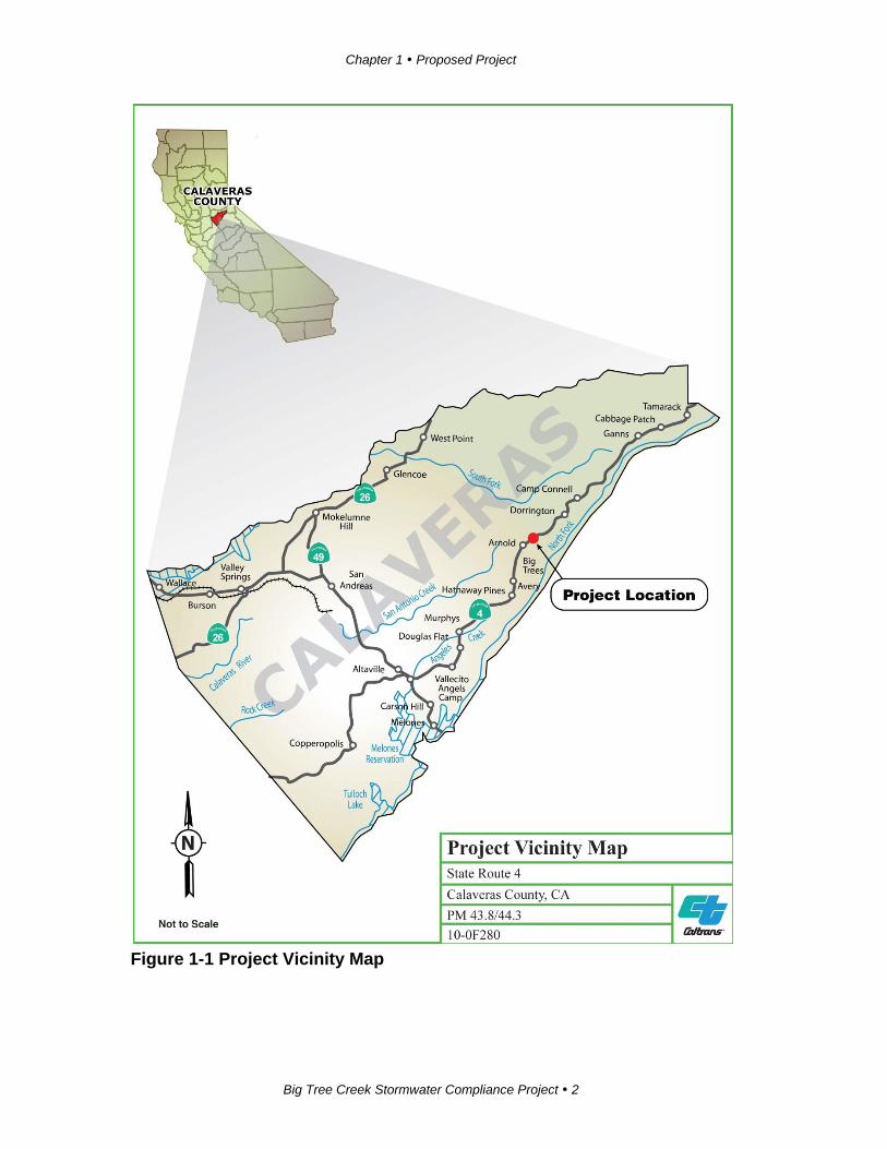
into Big Tree Creek within the Calaveras Big Trees State Park. See Figure 1-1 for the
Project Vicinity Map and Figure 1-2 for the Project Location Map.
Caltrans will widen State Route 4 to provide a storage area for plowed snow, so the
snow will not accumulate on the slope of the creek. Snow on the road accumulates
sands from de-icing work done by maintenance crews. Snow-clearing work blows the
snow and sand onto the slope of the creek; when the snow melts, that debris enters
Big Tree Creek.
The project is programmed in the 2012 State Highway Operations and Protection
Program under the 20.10.201.335 Stormwater Mitigation Program with programming
in the 2015/2016 fiscal year.
1.2 Purpose and Need
1.2.1 Purpose
The purpose of the project is to bring Caltrans into compliance with the National
Pollutant Discharge Elimination System and Caltrans Stormwater Management Plan.
Chapter 1 Proposed Project
Big Tree Creek Stormwater Compliance Project 2
Figure 1-1 Project Vicinity Map

Chapter 1 Proposed Project
Big Tree Creek Stormwater Compliance Project 3
Figure 1-2 Project Location Map
1.2.2 Need
This narrow two-lane highway with minimal shoulders goes through a densely
wooded area where little sunlight reaches the roadway. Because of the shady
conditions, great effort is required to control icy pavement and for snow removal
crews to keep the highway clear for the traveling public. Caltrans’ current ice control
method used during winter months spreads sand on the icy roadway surface to
improve vehicle traction. Because there isn’t enough room to plow and store the snow
just off the pavement, snow removal crews—using either a snow blower or plow,
depending on depth of the snow—blow the snow-mixed-with-traction-sand from the
pavement surface. The blown debris falls onto the slope banks along the creek. When
rain falls or when the snow melts, the sand drops into Big Tree Creek. This results in
a violation of the current National Pollutant Discharge Elimination System permit,
which requires Caltrans to prevent non-stormwater discharges from going into the
creek.
Tree removal alone, to allow sunlight to hit the roadway, is not sufficient to eliminate
the need for de-icing. Due to the angle of the sun, removal of the trees to allow
sunlight to reach the pavement is not practical; many trees would have to be removed,
Chapter 1 Proposed Project
Big Tree Creek Stormwater Compliance Project 4
and that would still not effectively solve the icy pavement conditions during the night
or early morning. Even after cutting away trees, traction sand would be needed.
1.3 Project Description
This project will bring Caltrans into compliance with the state’s Stormwater
Management Plan and the National Pollutant Discharge Elimination System permit.
The permit requires Caltrans to make best efforts to address and prevent non-
stormwater discharges into Big Tree Creek. Caltrans has developed two build
alternatives to address this violation.
There are two build alternatives and a No-Build Alternative under consideration.
1.3.1 Build Alternatives
Common Design Features of the Build Alternatives
Both build alternatives will do the following:
Create storage capacity for snowfall and prevent sand and other debris from
getting into Big Tree Creek by constructing gutters along the shoulders on
both sides of State Route 4.
Widen shoulders on the highway to 8 feet (shoulder widths currently range
from 0 to 1 foot).
Construct a 10-foot-wide paved gutter on the westbound side and a 3-foot-
wide paved gutter on the eastbound side.
Cut back the embankment to expose up to 10 feet of hillside.
Overlay existing pavement with asphalt concrete.
Modify five existing drainage facilities, and construct new drainage, which
will be built as traction sand traps. Traction sand traps are permanent
treatment devices that temporarily detain sediment-laden runoff.
Unique Features of the Build Alternatives
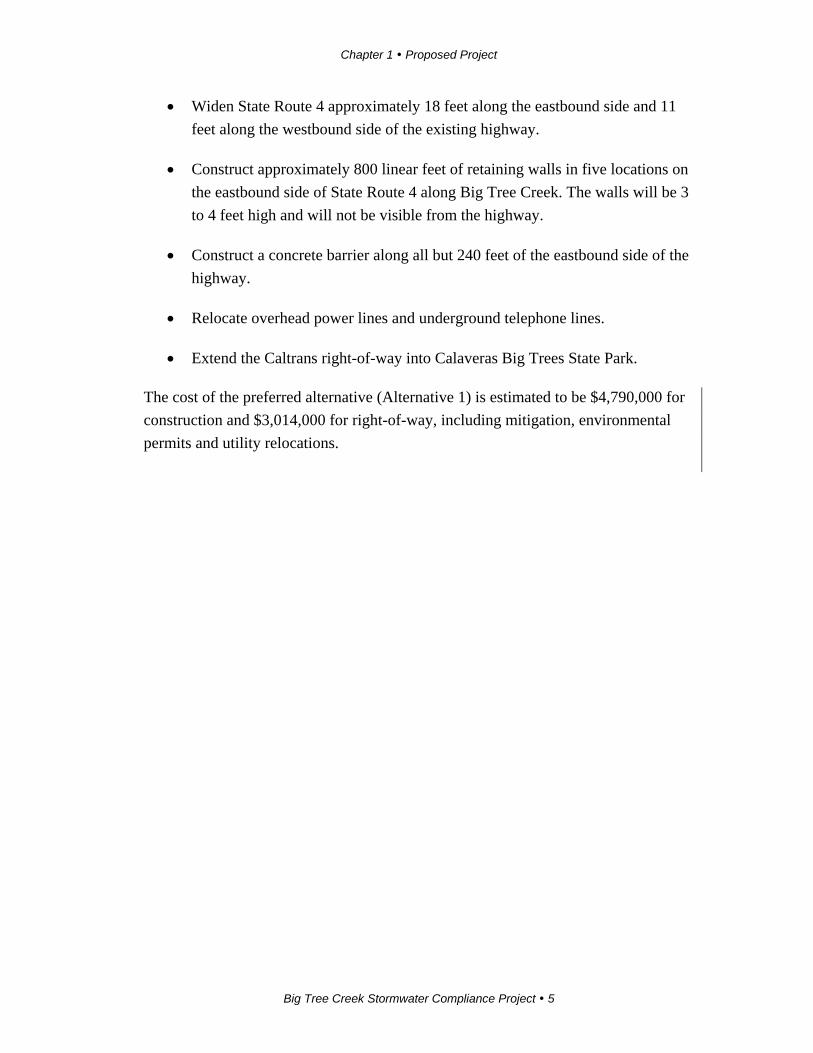
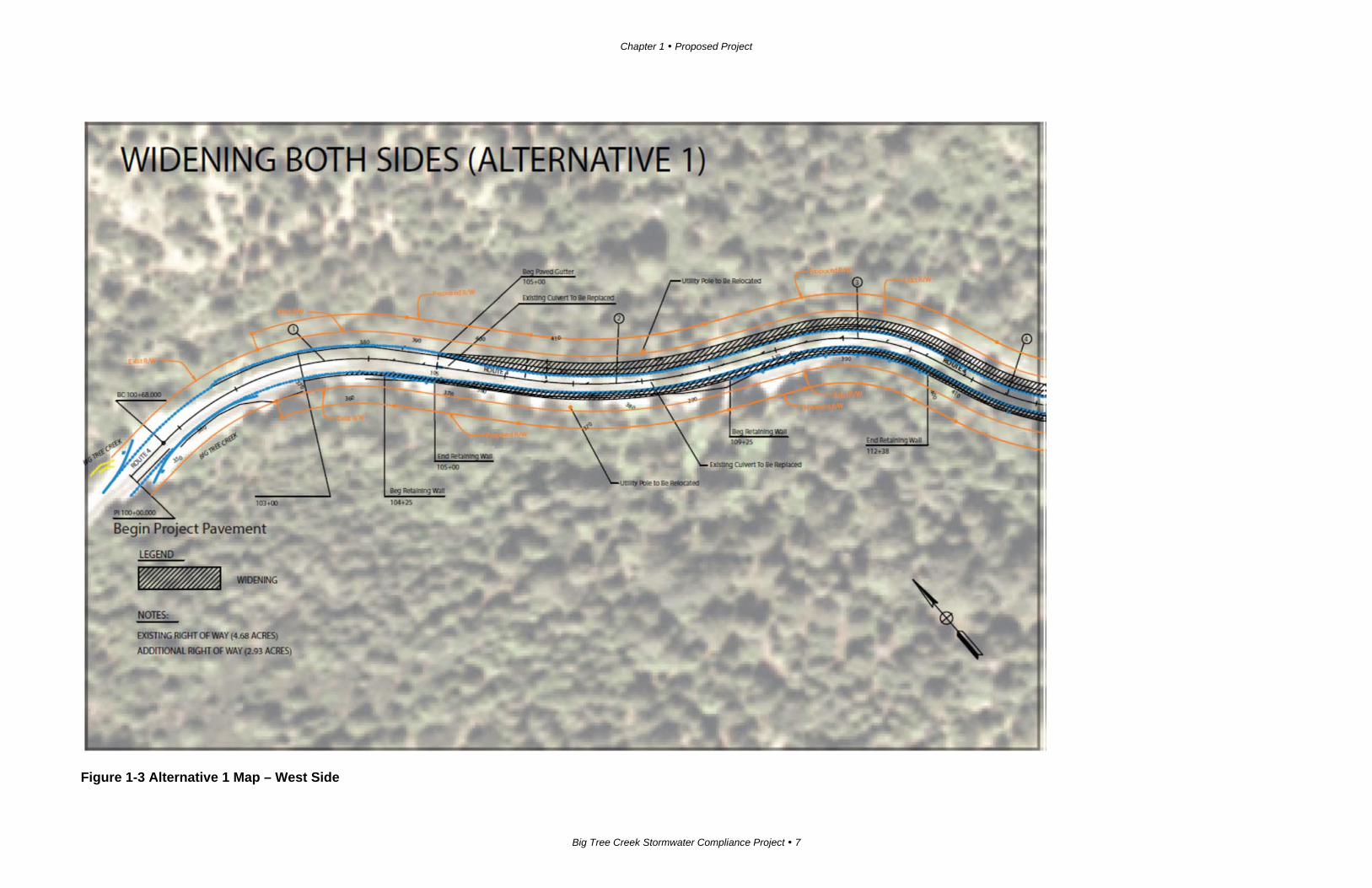
Alternative 1
Alternative 1 will do the following:
Chapter 1 Proposed Project
Big Tree Creek Stormwater Compliance Project 5
Widen State Route 4 approximately 18 feet along the eastbound side and 11
feet along the westbound side of the existing highway.
Construct approximately 800 linear feet of retaining walls in five locations on
the eastbound side of State Route 4 along Big Tree Creek. The walls will be 3
to 4 feet high and will not be visible from the highway.
Construct a concrete barrier along all but 240 feet of the eastbound side of the
highway.
Relocate overhead power lines and underground telephone lines.
Extend the Caltrans right-of-way into Calaveras Big Trees State Park.
The cost of the preferred alternative (Alternative 1) is estimated to be $4,790,000 for
construction and $3,014,000 for right-of-way, including mitigation, environmental
permits and utility relocations.

Chapter 1 Proposed Project
Big Tree Creek Stormwater Compliance Project 7
Figure 1-3 Alternative 1 Map – West Side

Chapter 1 Proposed Project
Big Tree Creek Stormwater Compliance Project 9
Figure 1-4 Alternative 1 Map – East Side

Chapter 1 Proposed Project
Big Tree Creek Stormwater Compliance Project 11
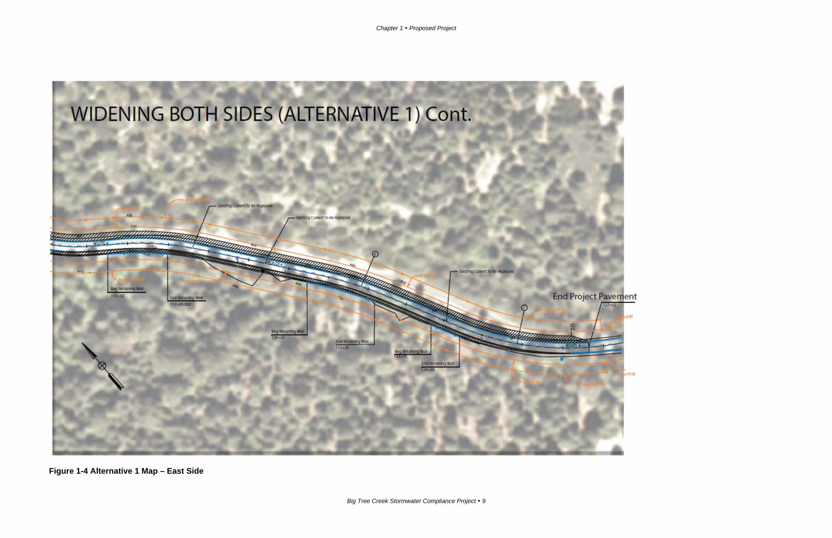
Figure 1-5 Alternative 1 Typical Cross Section
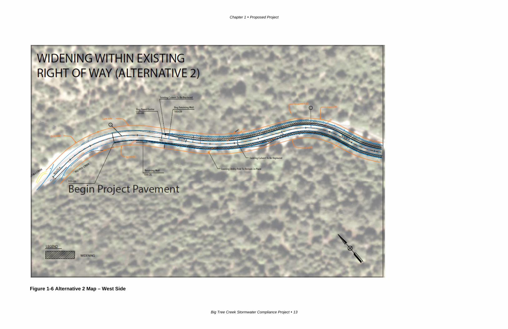
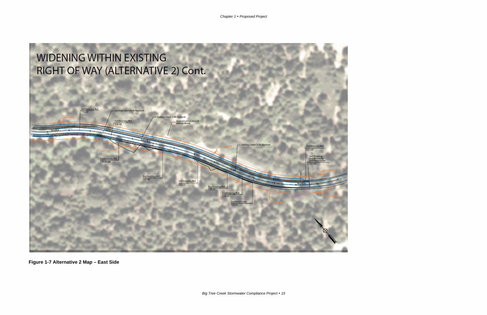
Alternative 2
Alternative 2 would do the following:
Widen State Route 4 within the state right-of-way.
Construct 1,665 linear feet of retaining wall on the eastbound side, 2 to 4 feet
high, below the highway, and a 2,060-foot-long retaining wall on the west
side of the highway. The westbound wall would be 6 to 16 feet high and
visible from the roadway, as it holds back the hillside above.
Construct a concrete barrier along all but 240 feet of the eastbound side of the
highway.
The cost of Alternative 2 is estimated to be $9,731,000 for construction and $594,978
for right-of-way, including mitigation, environmental permits and utility relocations.

Chapter 1 Proposed Project
Big Tree Creek Stormwater Compliance Project 13
Figure 1-6 Alternative 2 Map – West Side

Chapter 1 Proposed Project
Big Tree Creek Stormwater Compliance Project 15
Figure 1-7 Alternative 2 Map – East Side

Chapter 1 Proposed Project
Big Tree Creek Stormwater Compliance Project 17
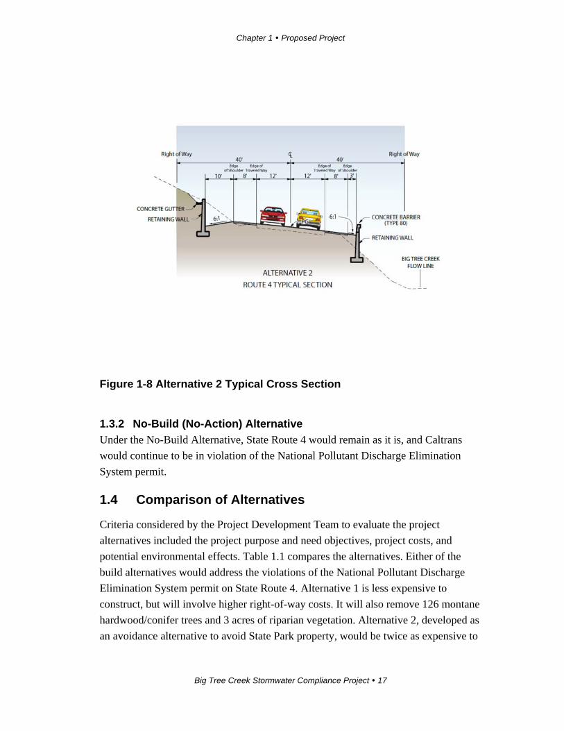
Figure 1-8 Alternative 2 Typical Cross Section
1.3.2 No-Build (No-Action) Alternative
Under the No-Build Alternative, State Route 4 would remain as it is, and Caltrans
would continue to be in violation of the National Pollutant Discharge Elimination
System permit.
1.4 Comparison of Alternatives
Criteria considered by the Project Development Team to evaluate the project
alternatives included the project purpose and need objectives, project costs, and
potential environmental effects. Table 1.1 compares the alternatives. Either of the
build alternatives would address the violations of the National Pollutant Discharge
Elimination System permit on State Route 4. Alternative 1 is less expensive to
construct, but will involve higher right-of-way costs. It will also remove 126 montane
hardwood/conifer trees and 3 acres of riparian vegetation. Alternative 2, developed as
an avoidance alternative to avoid State Park property, would be twice as expensive to
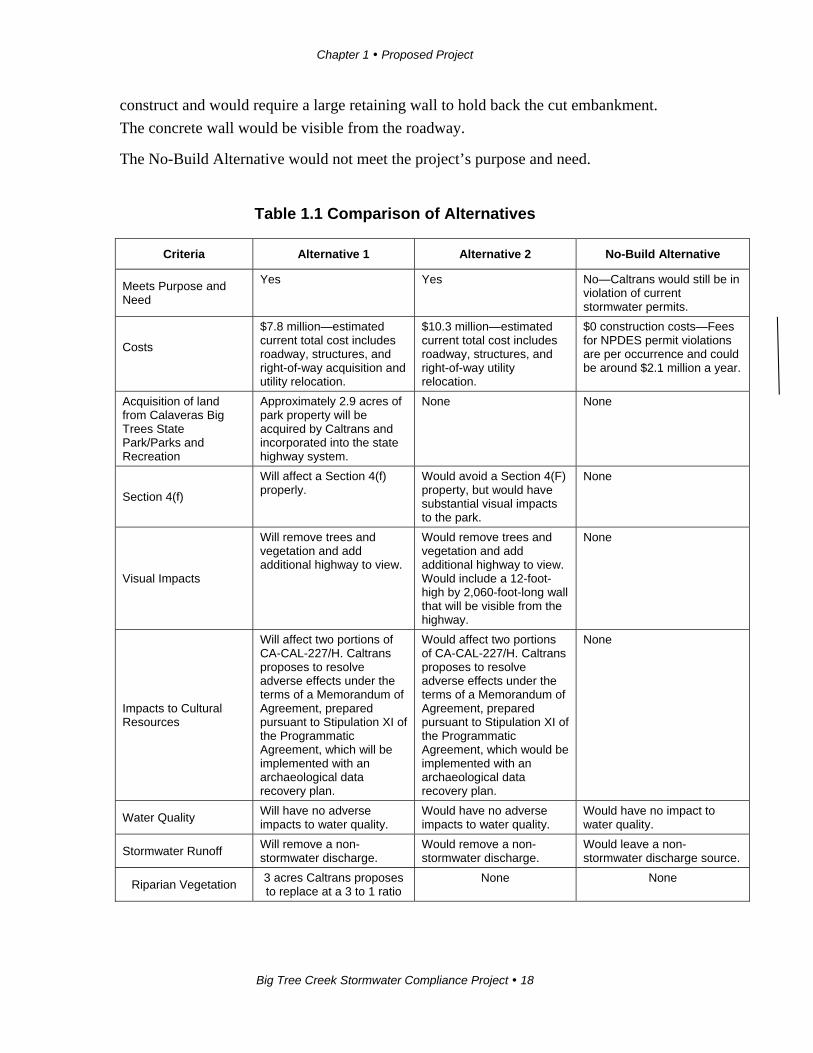
Chapter 1 Proposed Project
Big Tree Creek Stormwater Compliance Project 18
construct and would require a large retaining wall to hold back the cut embankment.
The concrete wall would be visible from the roadway.
The No-Build Alternative would not meet the project’s purpose and need.
Table 1.1 Comparison of Alternatives
Criteria Alternative 1 Alternative 2 No-Build Alternative
Meets Purpose and Need
Yes Yes No—Caltrans would still be in violation of current stormwater permits.
Costs
$7.8 million—estimated current total cost includes roadway, structures, and right-of-way acquisition and utility relocation.
$10.3 million—estimated current total cost includes roadway, structures, and right-of-way utility relocation.
$0 construction costs—Fees for NPDES permit violations are per occurrence and could be around $2.1 million a year.
Acquisition of land from Calaveras Big Trees State Park/Parks and Recreation
Approximately 2.9 acres of park property will be acquired by Caltrans and incorporated into the state highway system.
None None
Section 4(f)
Will affect a Section 4(f) properly.
Would avoid a Section 4(F) property, but would have substantial visual impacts to the park.
None
Visual Impacts
Will remove trees and vegetation and add additional highway to view.
Would remove trees and vegetation and add additional highway to view. Would include a 12-foot-high by 2,060-foot-long wall that will be visible from the highway.
None
Impacts to Cultural Resources
Will affect two portions of CA-CAL-227/H. Caltrans proposes to resolve adverse effects under the terms of a Memorandum of Agreement, prepared pursuant to Stipulation XI of the Programmatic Agreement, which will be implemented with an archaeological data recovery plan.
Would affect two portions of CA-CAL-227/H. Caltrans proposes to resolve adverse effects under the terms of a Memorandum of Agreement, prepared pursuant to Stipulation XI of the Programmatic Agreement, which would be implemented with an archaeological data recovery plan.
None
Water Quality Will have no adverse impacts to water quality.
Would have no adverse impacts to water quality.
Would have no impact to water quality.
Stormwater Runoff Will remove a non-stormwater discharge.
Would remove a non-stormwater discharge.
Would leave a non-stormwater discharge source.
Riparian Vegetation 3 acres Caltrans proposes to replace at a 3 to 1 ratio
None None
Chapter 1 Proposed Project
Big Tree Creek Stormwater Compliance Project 19
1.5 Identification of a Preferred Alternative
After the public circulation period, all comments were considered, and Caltrans
selected a preferred alternative and made the final determination of the project’s
effect on the environment. The project team selected Alternative 1 as the preferred
alternative for this project. While this alternative will acquire 6 acres of Section 4(f)
property, it will minimize visual impacts associated with Alternative 2. Alternative 2
will include a 16-foot wall visible from State Route 4. Alternative 2 is also opposed
by the Calaveras Big Trees State Park staff.
1.6 Alternatives Considered but Eliminated from Further Discussion
Widen to the North (formerly Alternative 3)
This alternative would have widened and moved the alignment of State Route 4 to
eliminate the retaining wall on the north bank of Big Tree Creek and the concrete
barrier on the eastbound side of State Route 4. This alternative was rejected because:
The design exceptions required for this alternative could not be justified for a
major reconstruction of State Route 4.
It would require removal of a greater amount of the vegetation, including
giant Sequoia and oak trees.
It would have a greater impact on known cultural resources.
Realignment of State Route 4 Away from Big Tree Creek (formerly Alternative
4)
This alternative would have realigned and bypassed the existing highway.
Constructed to current design standards, this alternative would have eliminated all
retaining walls and impacts to Big Tree Creek. This alternative is not viable and was
rejected because:
It would greatly increase the impacts to vegetation, including giant Sequoia
redwood and oak trees.
It would require the acquisition of 8.4 acres from state parklands for right-of-
way, increasing Section 4(f) impacts, because it would require constructing
new highway instead of just widening existing roadway.
Chapter 1 Proposed Project
Big Tree Creek Stormwater Compliance Project 20
It would increase the impact to known cultural resources.
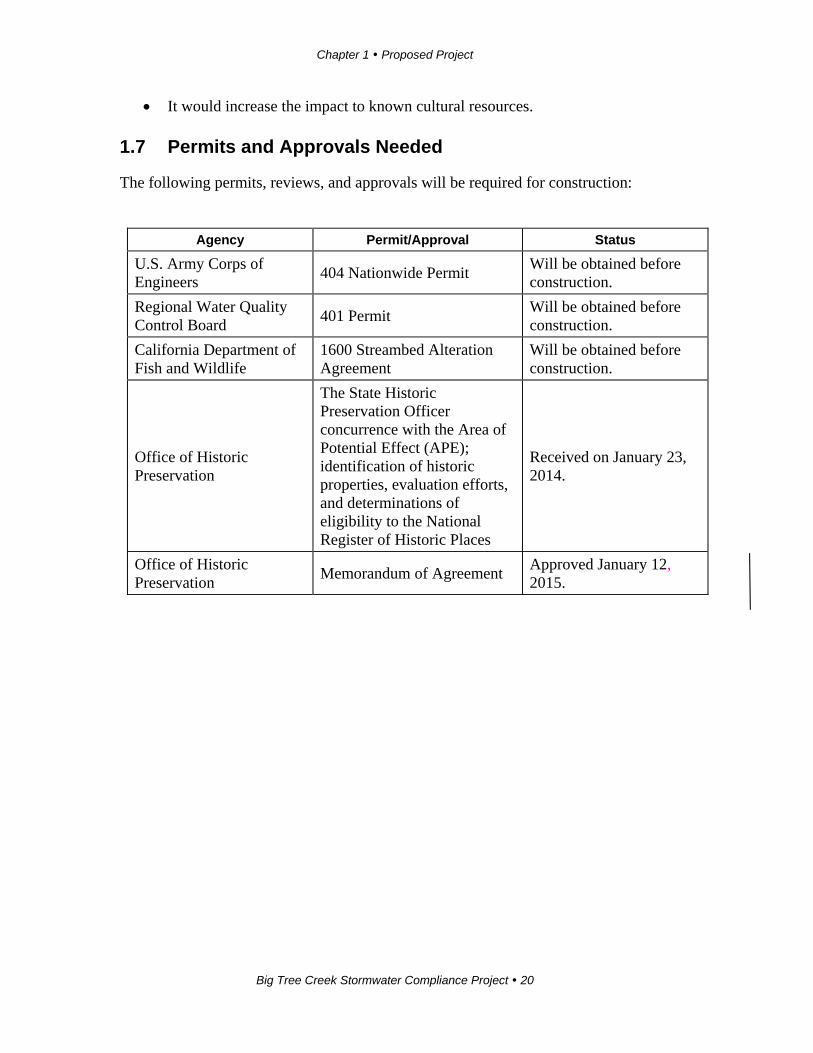
1.7 Permits and Approvals Needed
The following permits, reviews, and approvals will be required for construction:
Agency Permit/Approval Status
U.S. Army Corps of Engineers
404 Nationwide Permit Will be obtained before construction.
Regional Water Quality Control Board
401 Permit Will be obtained before construction.
California Department of Fish and Wildlife
1600 Streambed Alteration Agreement
Will be obtained before construction.
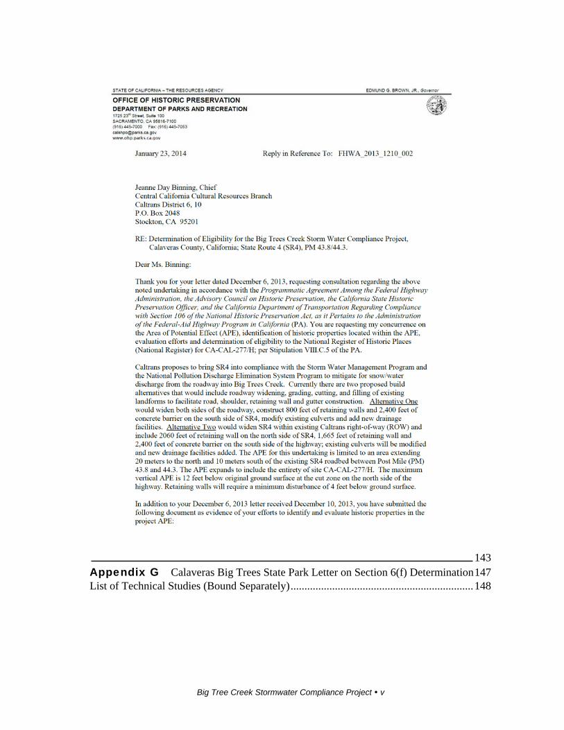
Office of Historic Preservation
The State Historic Preservation Officer concurrence with the Area of Potential Effect (APE); identification of historic properties, evaluation efforts, and determinations of eligibility to the National Register of Historic Places
Received on January 23, 2014.
Office of Historic Preservation
Memorandum of Agreement Approved January 12, 2015.
Big Tree Creek Stormwater Compliance Project 21
Chapter 2 Affected Environment, Environmental Consequences, and Avoidance, Minimization, and/or Mitigation Measures
As part of the scopin g and environmental analysis done for the project, the following
environmental issues were considered, but no adverse impacts were identified.
Consequently, there is no further discussion of these issues in this document.
Wild and Scenic Rivers—There are no wild and scenic rivers within the project
area. (National Wild and Scenic Rivers System website,
http://www.rivers.gov/california.php)
Growth—The project will not cause or remove barriers to growth.
Farmlands/Timberlands—There is no farmland within the project area. While
there are numerous trees in the project area, they are all within the state park
boundaries and therefore not available for harvest. As such, no timberland will be
affected.
Community Impacts—The project will not affect an existing community nor
community cohesion because it lies within a state park.
Relocations—The project will not require the relocation of businesses or
residences.
Environmental Justice—The project will not have a disproportionate and adverse
impact on a low-income or minority community.
Hydrology/Floodplain—The project lies outside the 500-year floodplain. There
will be no longitudinal encroachments within Big Tree Creek.
Geology/Soil/Seismic/Topography—No major geological features are in the
project area. No geologic or seismic features will alter the project design or affect
public health. (Draft Geotechnical Report, 2009)
Paleontology—The project is not expected to affect paleontological resources.
(Paleontology Identification Report, revised March 2014)
Hazardous Waste or Materials—The project is not expected to encounter
hazardous waste or materials. (Initial Site Assessment, December 2009)
Chapter 2 Affected Environment, Environmental Consequences, and Avoidance, Minimization, and/or Mitigation Measures
Big Tree Creek Stormwater Compliance Project 22
Air Quality—The project is exempt from air quality determination under the
category of “widening narrow pavements or reconstructing bridges (no additional
travel lanes) and is not expected to cause further violations of air quality
standards. (Air, Noise, Water Report, July 2013)
Noise—Projects subject to Caltrans’ Traffic Noise Analysis Protocol are projects
defined as Type I projects in Section 23 Code of Federal Regulations. A Type I
project is defined as: “A proposed federal or federal-aid highway project of the
construction of a highway on a new location, or the physical alteration of an
existing which significantly changes either the horizontal or vertical alignment or
increase the number of through-traffic lanes.” This project will neither increase
the existing traffic capacity nor alter the location of traffic lanes. (Air, Noise,
Water Report, July 2013)
Plant Species—The project is not expected to have an effect on plant species.
(Natural Environment Study, December 2013/Natural Environment Study
Addendum March 2014)
Threatened and Endangered Species—The project is not expected to have an
effect on threatened and endangered animal or plant species. (Natural
Environment Study, December 2013/Natural Environment Study Addendum
March 2014)
2.1 Human Environment
2.1.1 Land Use
2.1.2 Parks and Recreational Facilities
Regulatory Environment
The project will affect facilities that are protected by the California Public Park
Preservation Act (California Public Resources Code Sections 5400-5409). The act
prohibits local and state agencies from acquiring any property that is in use as a
public park at the time of acquisition unless the acquiring agency pays sufficient
compensation or land, or both, to enable the operator to replace the parkland and any
park facilities on that land.
Affected Environment
Calaveras Big Trees State Park, established in 1931, is a California state park
administered by the California Department of Parks and Recreation in Calaveras
County (see Figure 2-1).
Chapter 2 Affected Environment, Environmental Consequences, and Avoidance, Minimization, and/or Mitigation Measures
Big Tree Creek Stormwater Compliance Project 23
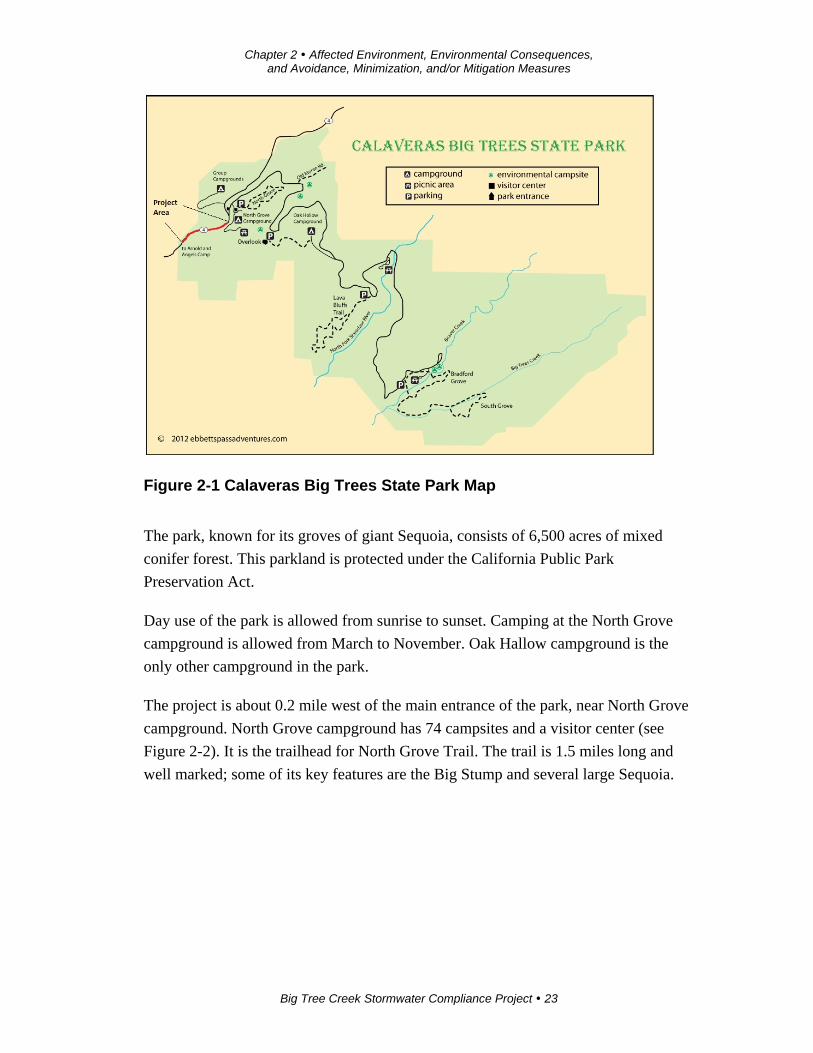
Figure 2-1 Calaveras Big Trees State Park Map
The park, known for its groves of giant Sequoia, consists of 6,500 acres of mixed
conifer forest. This parkland is protected under the California Public Park
Preservation Act.
Day use of the park is allowed from sunrise to sunset. Camping at the North Grove
campground is allowed from March to November. Oak Hallow campground is the
only other campground in the park.
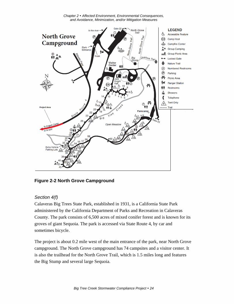
The project is about 0.2 mile west of the main entrance of the park, near North Grove
campground. North Grove campground has 74 campsites and a visitor center (see
Figure 2-2). It is the trailhead for North Grove Trail. The trail is 1.5 miles long and
well marked; some of its key features are the Big Stump and several large Sequoia.
Chapter 2 Affected Environment, Environmental Consequences, and Avoidance, Minimization, and/or Mitigation Measures
Big Tree Creek Stormwater Compliance Project 24
Figure 2-2 North Grove Campground
Section 4(f)
Calaveras Big Trees State Park, established in 1931, is a California State Park
administered by the California Department of Parks and Recreation in Calaveras
County. The park consists of 6,500 acres of mixed conifer forest and is known for its
groves of giant Sequoia. The park is accessed via State Route 4, by car and
sometimes bicycle.
The project is about 0.2 mile west of the main entrance of the park, near North Grove
campground. The North Grove campground has 74 campsites and a visitor center. It
is also the trailhead for the North Grove Trail, which is 1.5 miles long and features
the Big Stump and several large Sequoia.
Chapter 2 Affected Environment, Environmental Consequences, and Avoidance, Minimization, and/or Mitigation Measures
Big Tree Creek Stormwater Compliance Project 25
It was determined that this project will have a de minimis impact on Calaveras Big
Trees State Park. Calaveras Big Trees State Park officials concurred with this
determination on October 29, 2014.
Section 6(f)
On August 1, 2014, the Office of Grants and Local Services with the California
Department of Parks and Recreation sent a letter to Caltrans (see Appendix G). The
letter indicated that while the project is within land protected under the Land and
Water Conservation Fund (Section 6(f)), the use of the specified park property for this
project would not be not incompatible with recreation uses and will not change or
restrict access to the park, so the project would not constitute a conversion of Section
6(f) property.
Environmental Consequences
Direct Impacts to Calaveras Big Trees State Park
Alternative 1 will acquire 2.9 acres of parkland for conversion to state highway;
Alternative 2 would not acquire any park right-of-way.
Alternative 1will convert a very small percentage (approximately 0.04%) of the
parkland within Calaveras Big Trees State Park from park use to transportation use.
No recreational facilities will be directly affected with this conversion.
The Caltrans Division of Right of Way and Land Surveys will coordinate with the
Calaveras Big Trees State Park to provide compensation under the Park Preservation
Act.
Visual
Visual impacts are addressed in the Visual section. See Section 2.1.4.
Construction Noise
There will be some construction noise but, to avoid affecting overnight camping,
construction will occur during the daytime.
Avoidance, Minimization, and/or Mitigation Measures
Alternative 1 will convert 2.9 acres of park property. The acquired property will
become part of the highway right-of-way.
Caltrans will address the direct impacts to park property by transferring $1.75 million
to Calaveras Big Trees State Park to fund the relocation of five campsites in North
Grove campground. The newly created campsites will be away from State Route 4

Chapter 2 Affected Environment, Environmental Consequences, and Avoidance, Minimization, and/or Mitigation Measures
Big Tree Creek Stormwater Compliance Project 26
and include expanded utilities, new trails and upgrades to meet current Americans
with Disabilities Act standards.
2.1.3 Utilities/Emergency Services
Affected Environment
An underground telephone line and an overhead power line occur within the project
area.
First responders to emergencies within the project area include the California
Highway Patrol, California State Park ranger staff, California Department of Forestry
and Fire Protection, and private emergency medical transportation.
The closest California Highway Patrol office is at 749 Mountain Ranch Road in San
Andreas (zip code 95249-9801), about 18 miles from the project area.
Environmental Consequences
Construction will require relocation of the underground telephone fiber optic line and
overhead power line. This will include moving two power poles.
Emergency services could be affected during construction due to temporarily
increased response times for emergency medical and fire services. Emergency
vehicles will receive preference for passage through any lane closures.
Avoidance, Minimization, and/or Mitigation Measures
The telephone and power lines will be moved before construction, and there will be
no disruption to service.
The project will always leave one travel lane open, providing access for emergency
responders.
2.1.4 Traffic and Transportation/Pedestrian and Bicycle Facilities
Regulatory Setting
Caltrans, as assigned by the Federal Highway Administration, directs that full
consideration should be given to the safe accommodation of pedestrians and
bicyclists during the development of federal-aid highway projects (see 23 Code of
Federal Regulations 652). It further directs that the special needs of the elderly and
the disabled must be considered in all federal-aid projects that include pedestrian
facilities. When current or anticipated pedestrian and/or bicycle traffic presents a
Chapter 2 Affected Environment, Environmental Consequences, and Avoidance, Minimization, and/or Mitigation Measures
Big Tree Creek Stormwater Compliance Project 27
potential conflict with motor vehicle traffic, every effort must be made to minimize
the detrimental effects on all highway users who share the facility.
In July 1999, the U.S. Department of Transportation issued an Accessibility Policy
Statement pledging a fully accessible multimodal transportation system. Accessibility
in federally assisted programs is governed by U.S. Department of Transportation
regulations (49 Code of Federal Regulations Part 27) implementing Section 504 of
the Rehabilitation Act (29 U.S. Code 794). The Federal Highway Administration has
enacted regulations for the implementation of the 1990 Americans with Disabilities
Act (ADA), including a commitment to build transportation facilities that provide
equal access for all persons. These regulations require application of the 1990
Americans with Disabilities Act requirements to federal-aid projects, including
Transportation Enhancement Activities.
Affected Environment
State Route 4 is a two-lane highway within the project area. The Calaveras County
Bike Master Plan (2007) shows State Route 4 from Arnold to Dorrington, which
includes the project area, with a proposed Class III bike lane. A Class III bike lane is
designated only by the use of signs. The long-term goal for all Class III routes is to
have at least 4 feet of pavement outside the travel way. This is typically provided by
the shoulders.
Currently, because the highway shoulders range in width from 0 to 1 foot, both
bicyclists and pedestrians use the existing highway to travel through the project area.
There are no signs warning motorists to watch for pedestrians or bicyclists.
Environmental Consequences
The project will be compatible with current bicyclist and pedestrian uses. The project
will provide 8-foot-wide shoulders within the project area. This will meet the
structure requirements for the ultimate goal of a Class III bike lane. The widened
shoulders will improve non-motorized vehicle travel but, because this segment of
State Route 4 is limited in length, the benefit will be minimal.
Avoidance, Minimization, and/or Mitigation Measures
No mitigation is proposed. No signs will be added within this short distance because
the project covers only 0.5 mile within the 6-mile distance of State Route 4 between
Arnold and Dorrington.
Chapter 2 Affected Environment, Environmental Consequences, and Avoidance, Minimization, and/or Mitigation Measures
Big Tree Creek Stormwater Compliance Project 28
2.1.5 Visual/Aesthetics
Regulatory Setting
The National Environmental Policy Act of 1969 as amended establishes that the
federal government use all practicable means to ensure all Americans safe, healthful,
productive, and aesthetically (emphasis added) and culturally pleasing surroundings
(42 U.S. Code 4331[b][2]). To further emphasize this point, the Federal Highway
Administration in its implementation of the National Environmental Policy Act (23
U.S. Code 109[h]) directs that final decisions on projects are to be made in the best
overall public interest taking into account adverse environmental impacts, including
among others, the destruction or disruption of aesthetic values.
The California Environmental Quality Act establishes that it is the policy of the State
to take all action necessary to provide the people of the State “with…enjoyment of
aesthetic, natural, scenic and historic environmental qualities” (California Public
Resources Code Section 21001[b]).
Affected Environment
A Visual Impact Assessment for the project was completed in August 2013.
The existing roadway is a two-lane highway that winds through the densely wooded
forest of the Sierra Nevada Mountains. The project is on a State Scenic Highway and
a National Scenic Byway. A State Scenic Highway is a highway for which a local
agency has developed a corridor protection program. Caltrans attempts to protect
these corridors as much as possible.
Regional Landscape
Defining the regional landscape establishes a frame of reference for comparing the
visual effects of the project and determining the significance of these effects. A
regional landscape is made up of various landscape components that distinguish it
from the next. Components of the regional landscape are landforms and land cover,
including such features as water, vegetation, and human-made development. The
following describes the landscape components of the project area.
Landforms
Natural landforms in the region include mountains and valleys. The project lies in a
region that is part of the western face of the Sierra Nevada Mountains. State Route 4
runs on an east-west alignment, crossing a series of rolling hills and small valley
meadows as it climbs in elevation eastward toward the volcanic landscape and
Chapter 2 Affected Environment, Environmental Consequences, and Avoidance, Minimization, and/or Mitigation Measures
Big Tree Creek Stormwater Compliance Project 29
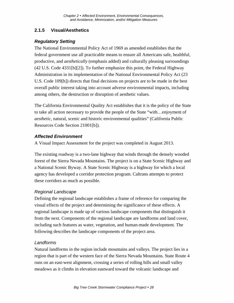
glacier-carved canyons near the crest of Ebbetts Pass summit. Tall trees line the
highway through the corridor (see Figure 2-3).
The project area has a north-slope orientation that is susceptible to snow drift
accumulation during winter months. Just south along the highway is Big Tree Creek,
where much of the winter snow is deposited.
Figure 2-3 Typical Project Area View
The Sierra Nevada Mountains have steep slopes and ravines that form a series of
ridgelines and deep and shallow valleys. Rocky outcrops exposed by roadway
excavation appear along portions of the highway. The contrast between the flat
topography of the Central Valley and the progressive incline to the Sierra foothills
and mountain region provides the viewer with a variety of visual experiences.
Within the project limits, the viewer has more limited views. Dense forest next to the
roadway restricts what motorists can see of the mountains and ridgelines, forcing the
viewer’s range to the immediate foreground and reducing middle-distance views to
just the roadway ahead. Long-distance views in project area are virtually nonexistent.
Land Cover
Physical material on the surface of the earth, such as rivers, rocks, human-made
objects including residences and commercial buildings, and trees and other
Chapter 2 Affected Environment, Environmental Consequences, and Avoidance, Minimization, and/or Mitigation Measures
Big Tree Creek Stormwater Compliance Project 30
vegetation, is referred to in this document as “land cover.” Throughout the State
Route 4 corridor is a variety of land cover characteristics that differ between the
valley, foothill and mountain landforms. These surface features visually define a
particular region or sub-region.
Water
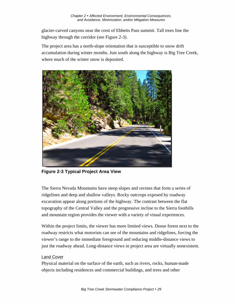
Surface water is an important visual element throughout much of the region, though
few water elements exist right next to or within the highway corridor. Big Tree Creek
is within the project area, but views of it from the highway are brief for westbound
travelers and only intermittent for eastbound travelers. From the eastbound lane in
particular, the riparian vegetation and forest understory, as well as the meandering
creek alignment, limit the motorist’s ability to see the creek (see Figure 2-4).
Figure 2-4 Big Tree Creek
Vegetation
Throughout the region, vegetation is a distinguishing component of the regional
landscape and visual character. Vegetation within the project area consists of a mixed
forest of densely planted confiners (evergreens), including redwoods, pines, and cedar
as well as some deciduous species, such as oak and dogwood trees (see Figures 2-3
and 2-5).

Chapter 2 Affected Environment, Environmental Consequences, and Avoidance, Minimization, and/or Mitigation Measures
Big Tree Creek Stormwater Compliance Project 31
The dense forest understory consists of both annual and perennial vegetation. This
diversity provides the forest floor with an array of plant forms and textures as well as
seasonal color. Riparian vegetation can be found lining the banks next to the slow-
moving Big Tree Creek, creating visually unique plant communities coexisting within
the forest environment (see Figure 2-4).
Figure 2-5 Forest Vegetation
Human-made Elements
Human-made elements, though not many, sit within the project area. Off-road
elements, such as building structures, park camping areas and overhead utility lines,
are found in the densely forested area. Coupled with sensitive placement or use of
natural earth-tone materials (wood, rock, etc.), the existing built environment goes
almost unnoticed by viewers (see Figure 2-6).
By contrast, the most noticeable human-made element is the State Route 4 roadway
surface itself and related elements (signs, guardrails, bridges, etc.). But the roadway,
while highly noticeable, becomes commonplace to the viewer because views of the
roadway are overshadowed by the natural surroundings (see Figures 2-3 and 2-5).
Chapter 2 Affected Environment, Environmental Consequences, and Avoidance, Minimization, and/or Mitigation Measures
Big Tree Creek Stormwater Compliance Project 32
Figure 2-6 “Built Environment” Structure in Park
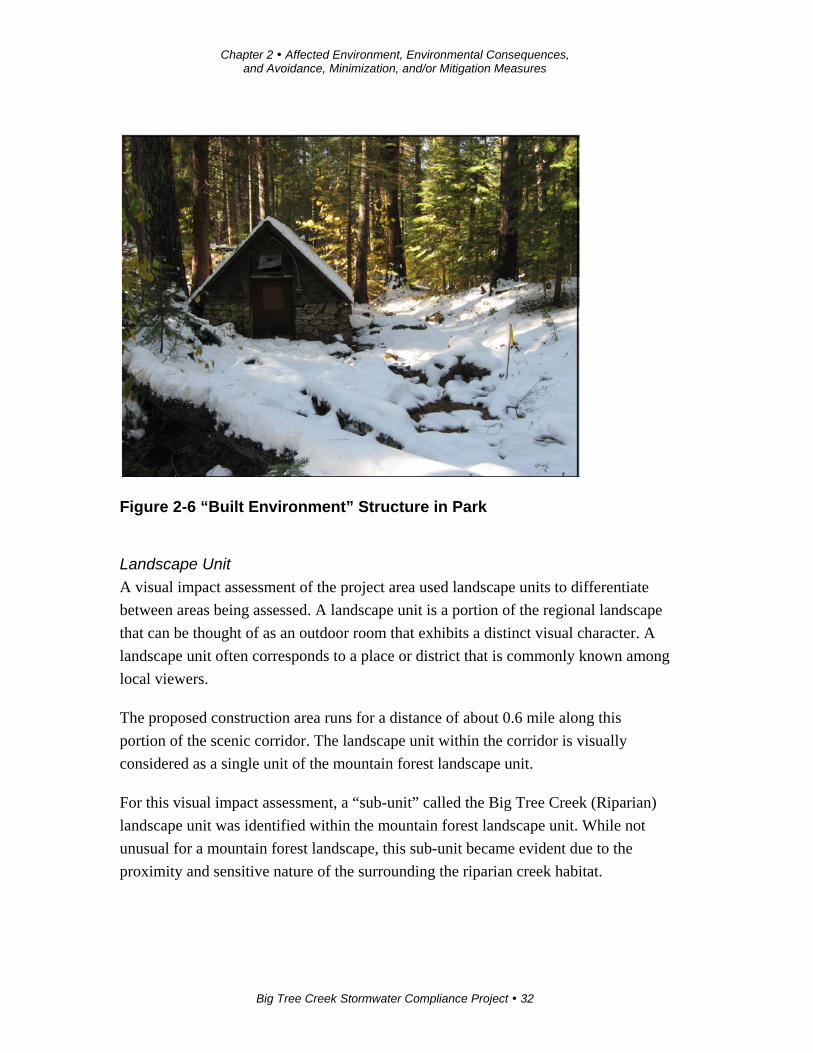
Landscape Unit
A visual impact assessment of the project area used landscape units to differentiate
between areas being assessed. A landscape unit is a portion of the regional landscape
that can be thought of as an outdoor room that exhibits a distinct visual character. A
landscape unit often corresponds to a place or district that is commonly known among
local viewers.
The proposed construction area runs for a distance of about 0.6 mile along this
portion of the scenic corridor. The landscape unit within the corridor is visually
considered as a single unit of the mountain forest landscape unit.
For this visual impact assessment, a “sub-unit” called the Big Tree Creek (Riparian)
landscape unit was identified within the mountain forest landscape unit. While not
unusual for a mountain forest landscape, this sub-unit became evident due to the
proximity and sensitive nature of the surrounding the riparian creek habitat.
Chapter 2 Affected Environment, Environmental Consequences, and Avoidance, Minimization, and/or Mitigation Measures
Big Tree Creek Stormwater Compliance Project 33
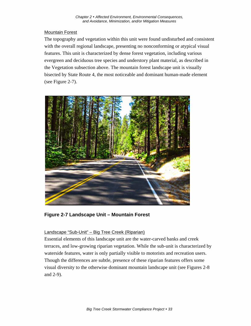
Mountain Forest
The topography and vegetation within this unit were found undisturbed and consistent
with the overall regional landscape, presenting no nonconforming or atypical visual
features. This unit is characterized by dense forest vegetation, including various
evergreen and deciduous tree species and understory plant material, as described in
the Vegetation subsection above. The mountain forest landscape unit is visually
bisected by State Route 4, the most noticeable and dominant human-made element
(see Figure 2-7).
Figure 2-7 Landscape Unit – Mountain Forest
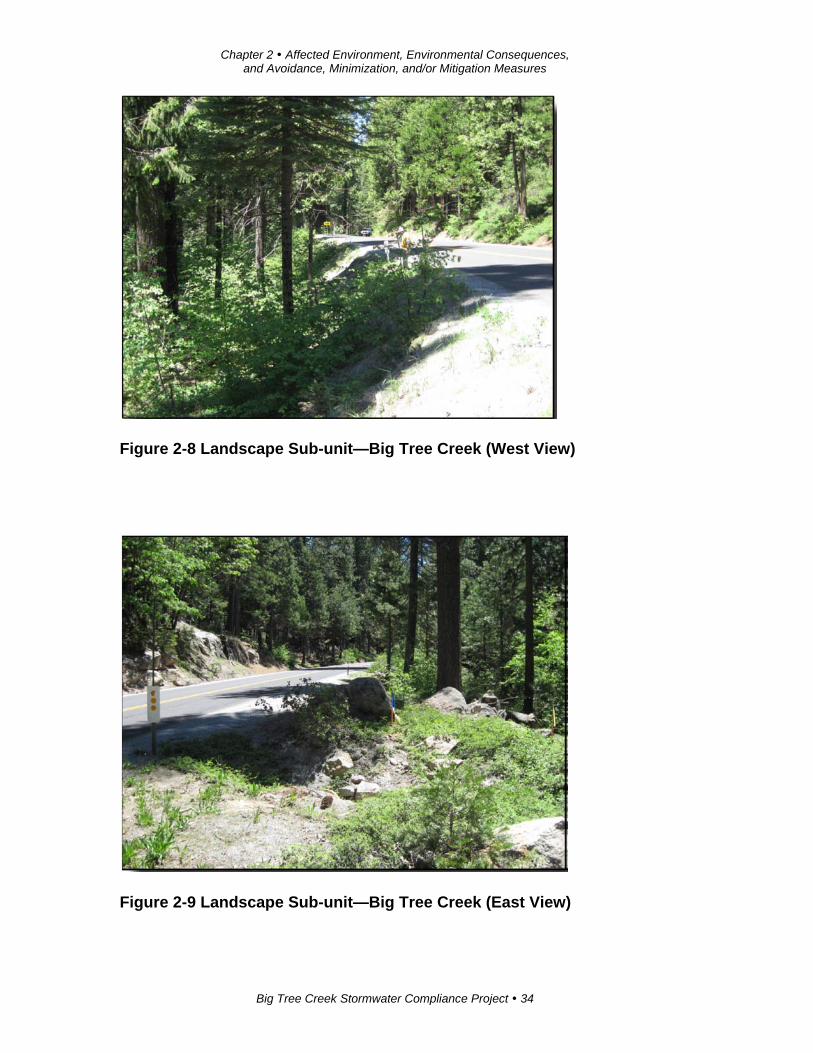
Landscape “Sub-Unit” – Big Tree Creek (Riparian)
Essential elements of this landscape unit are the water-carved banks and creek
terraces, and low-growing riparian vegetation. While the sub-unit is characterized by
waterside features, water is only partially visible to motorists and recreation users.
Though the differences are subtle, presence of these riparian features offers some
visual diversity to the otherwise dominant mountain landscape unit (see Figures 2-8
and 2-9).
Chapter 2 Affected Environment, Environmental Consequences, and Avoidance, Minimization, and/or Mitigation Measures
Big Tree Creek Stormwater Compliance Project 34
Figure 2-8 Landscape Sub-unit—Big Tree Creek (West View)
Figure 2-9 Landscape Sub-unit—Big Tree Creek (East View)
Chapter 2 Affected Environment, Environmental Consequences, and Avoidance, Minimization, and/or Mitigation Measures
Big Tree Creek Stormwater Compliance Project 35
Project Views
Views that represent a project area are a subset of each landscape unit and are
composed of all surface areas visible from an observer’s viewpoint. The limits of a
specific view include locations of views from the proposed project. The view also
includes the location of viewers likely to be affected by visual changes brought about
by the project features. Views for this project include the landscape that is visible
from State Route 4 and various vantage points outside the highway right-of-way and
within the project limits.
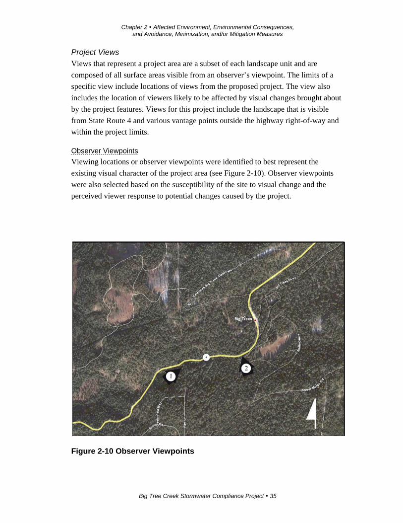
Observer Viewpoints
Viewing locations or observer viewpoints were identified to best represent the
existing visual character of the project area (see Figure 2-10). Observer viewpoints
were also selected based on the susceptibility of the site to visual change and the
perceived viewer response to potential changes caused by the project.
Figure 2-10 Observer Viewpoints
Chapter 2 Affected Environment, Environmental Consequences, and Avoidance, Minimization, and/or Mitigation Measures
Big Tree Creek Stormwater Compliance Project 36
Viewer Sensitivity and Response
A change in visual character cannot be described as having either good or bad
attributes until it is compared with the viewer response to that change. Public opinion
concerning established scenic values of a regional landscape and opinion on how
proposed built elements will affect these values are the basis for evaluating the
contrast in visual character.
Development Guidelines
State Route 4 has long been recognized for its rich scenic resources by many viewer
groups. Consequently, like-minded local groups and state and federal agencies have
organized to document shared community values and opinions in an effort to preserve
and maintain this natural visual heritage and resource. The following designations and
planning and guidance documents indicate the degree of sensitivity concerning the
aesthetic character of this highway corridor.
Guidance Documents
State Scenic Highway Designation – On November 9, 1971, State Route 4 was
designated an Official State Scenic Highway for its natural beauty and to preserve its
scenic assets for the region for posterity. The designation of Official State Scenic
Highway requires local jurisdictions to adopt adjacent land use regulations and
develop ordinances controlling the appearance of earthwork, landscaping, vegetation,
structures and equipment within the scenic corridor surrounding the highway. The
California Streets and Highway Code states that, concerning State Scenic Highways,
Caltrans “shall give special attention both to the impact of the highway and the
landscape and to the highway’s visual appearance.”
National Scenic Byway Designation – On September 22, 2005, State Route 4 was
officially designated the Ebbetts Pass National Scenic Byway by the U.S. Secretary of
Transportation. A mission of this national program is to enhance appreciation and
public knowledge of the scenic, cultural and historic resources along the byway and
throughout the nation. The National Scenic Byway program seeks to maintain these
resources through the development of a corridor management plan that specifically
includes scenic issues.
Corridor Management Plan for the Ebbetts Pass National Scenic Byway – In
August 2004, the Corridor Management Plan for the Ebbetts Pass National Scenic
Byway was completed and submitted as a prerequisite for the national designation.
The Ebbetts Pass plan is designed to provide guidance to federal, state, and local
Chapter 2 Affected Environment, Environmental Consequences, and Avoidance, Minimization, and/or Mitigation Measures
Big Tree Creek Stormwater Compliance Project 37
agencies, private landowners, and interested businesses to showcase the unique
scenery, historical significance and extensive recreational opportunities present along
this route. Some of the items addressed include existing land use, commerce, highway
conditions, management strategies, signage and advertising control, and the
jurisdictional boundaries of both Calaveras and Alpine counties.
The plan’s stated goal is “to protect and enhance the intrinsic qualities of the corridor
for the enjoyment of present and future generations.” The plan defines the intrinsic
qualities as “inherent, essential, unique, or irreplaceable features representative or
distinctly characteristic of an area.”
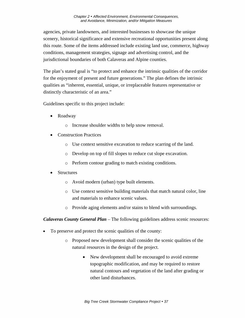
Guidelines specific to this project include:
Roadway
o Increase shoulder widths to help snow removal.
Construction Practices
o Use context sensitive excavation to reduce scarring of the land.
o Develop on top of fill slopes to reduce cut slope excavation.
o Perform contour grading to match existing conditions.
Structures
o Avoid modern (urban) type built elements.
o Use context sensitive building materials that match natural color, line
and materials to enhance scenic values.
o Provide aging elements and/or stains to blend with surroundings.
Calaveras County General Plan – The following guidelines address scenic resources:
To preserve and protect the scenic qualities of the county:
o Proposed new development shall consider the scenic qualities of the
natural resources in the design of the project.
New development shall be encouraged to avoid extreme
topographic modification, and may be required to restore
natural contours and vegetation of the land after grading or
other land disturbances.
Chapter 2 Affected Environment, Environmental Consequences, and Avoidance, Minimization, and/or Mitigation Measures
Big Tree Creek Stormwater Compliance Project 38
New development shall be encouraged to be designed in a
manner that is sensitive to available natural resources.
Calaveras Big Trees State Park General Plan – In February 1989, Calaveras Big
Trees State Park adopted its General Plan. Specific to this project, the plan addresses
concerns related to general vegetation management and preservation as well as
concerns on aesthetic resource preservation. The following are design guidelines that
specifically relate to the proposed project:
Perpetuate natural plant communities to be naturally managed toward normal
plant successional trends as found in the natural environment.
Restore vegetation where land has been modified to bring plant communities
back into their natural condition or habitat.
Devise and implement specific vegetation management programs as necessary
and appropriate to achieve these goals.
Design construction elements to preserve existing scenic qualities and not to
create incongruous intrusions or unnecessary interference with scenic features.
U.S. Department of Agriculture Forest Service – Stanislaus National Forest Service
manages most of the Ebbetts Pass Scenic Byway scenic resources. Service guidelines
were created to maintain and enhance State Route 4 as a forested scenic corridor. The
following are some of the pertinent design guidelines that specifically relate to the
proposed project:
Construction features should remain subordinate to the natural environment.
Natural colors of brown, beige or forest green should be considered.
Building materials such as wood and rock versus plastic or metal should be
used.
Boundary edges should be blended having a feathered or ragged edge to
mimic natural boundary patterns.
Chapter 2 Affected Environment, Environmental Consequences, and Avoidance, Minimization, and/or Mitigation Measures
Big Tree Creek Stormwater Compliance Project 39
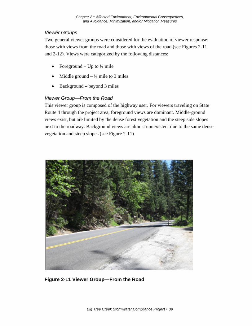
Viewer Groups
Two general viewer groups were considered for the evaluation of viewer response:
those with views from the road and those with views of the road (see Figures 2-11
and 2-12). Views were categorized by the following distances:
Foreground – Up to ¼ mile
Middle ground – ¼ mile to 3 miles
Background – beyond 3 miles
Viewer Group—From the Road
This viewer group is composed of the highway user. For viewers traveling on State
Route 4 through the project area, foreground views are dominant. Middle-ground
views exist, but are limited by the dense forest vegetation and the steep side slopes
next to the roadway. Background views are almost nonexistent due to the same dense
vegetation and steep slopes (see Figure 2-11).
Figure 2-11 Viewer Group—From the Road
Chapter 2 Affected Environment, Environmental Consequences, and Avoidance, Minimization, and/or Mitigation Measures
Big Tree Creek Stormwater Compliance Project 40
Viewers from State Route 4 are mostly motorists, including skiers, campers, hunters
and sightseers, as well as the local user, including business owners, employees, and
private property owners. Bicyclists also use this road.
Generally, awareness of visual resources by these highway users is expected to vary
with their specific activity. Tourists, which make up many viewers on State Route 4,
often have a high awareness of the visual resources around them, but are less
sensitive to specific changes in that environment. This is particularly true for first-
time visitors and those less familiar with a specific area.
Conversely, frequent visitors possess a higher degree of sensitivity to visual change
because of their familiarity with the location. In general, however, highway users
within the project location experience the area as a cumulative sequence of views and
may not focus on specific roadway features. The exception may be a bicyclist;
because of proximity and the slower rate of speed moving through the area, the
bicyclist may detect changes to an environment that do match the overall regional
landscape that go unnoticed to vehicular traffic.
Lastly, local residents—those who live and work in the area as well as people who
have vacation homes in the area—are the most sensitive to aesthetic differences
because they are familiar with the environmental surroundings.
Viewer Group—Of the Road
This viewer group is made up of people who can see the road project or any of its
components from offsite locations. People in this group are Calaveras Big Trees State
Park users, particularly users of the park facilities near the northwest park boundary.
This is a small group of viewers. But, from these vantage points, these viewers are
close to the project site, between the foreground and middle-ground ranges (see
Figure 2-12). These viewers include day users, campers and hikers, and park
personnel. These views are limited by the surrounding forest and riparian vegetation.
Chapter 2 Affected Environment, Environmental Consequences, and Avoidance, Minimization, and/or Mitigation Measures
Big Tree Creek Stormwater Compliance Project 41
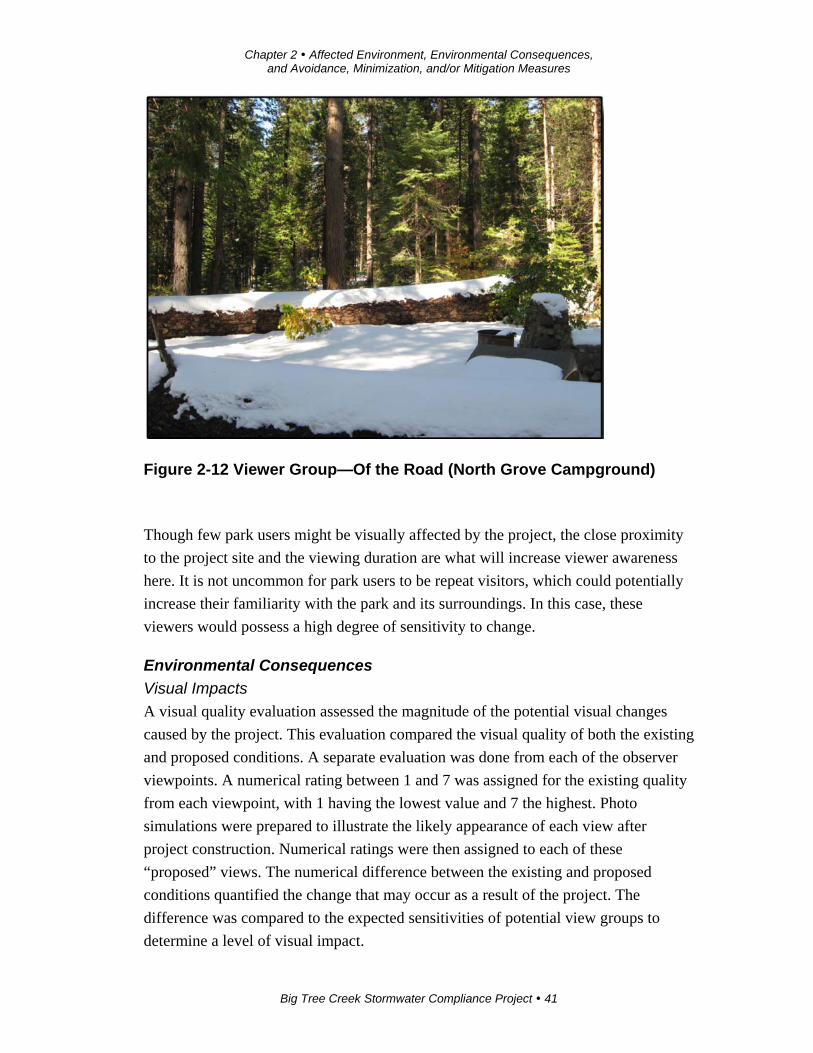
Figure 2-12 Viewer Group—Of the Road (North Grove Campground)
Though few park users might be visually affected by the project, the close proximity
to the project site and the viewing duration are what will increase viewer awareness
here. It is not uncommon for park users to be repeat visitors, which could potentially
increase their familiarity with the park and its surroundings. In this case, these
viewers would possess a high degree of sensitivity to change.
Environmental Consequences
Visual Impacts
A visual quality evaluation assessed the magnitude of the potential visual changes
caused by the project. This evaluation compared the visual quality of both the existing
and proposed conditions. A separate evaluation was done from each of the observer
viewpoints. A numerical rating between 1 and 7 was assigned for the existing quality
from each viewpoint, with 1 having the lowest value and 7 the highest. Photo
simulations were prepared to illustrate the likely appearance of each view after
project construction. Numerical ratings were then assigned to each of these
“proposed” views. The numerical difference between the existing and proposed
conditions quantified the change that may occur as a result of the project. The
difference was compared to the expected sensitivities of potential view groups to
determine a level of visual impact.

Chapter 2 Affected Environment, Environmental Consequences, and Avoidance, Minimization, and/or Mitigation Measures
Big Tree Creek Stormwater Compliance Project 42
The numerical ratings were based on three criteria: vividness, intactness, and unity,
defined as follows:
Vividness is the visual power or memorability of the landscape components as
they combine in distinctive visual patterns.
Intactness is the visual integrity of the landscape and its freedom from non-
typical encroaching elements. If all of the various elements of a landscape
seem to “belong” together, there will be a high level of intactness.
Unity is the visual harmony of the landscape considered as a whole. Unity
represents the degree to which the visual elements maintain a coherent visual
pattern.
Visual Quality Evaluation by Observer Viewpoints
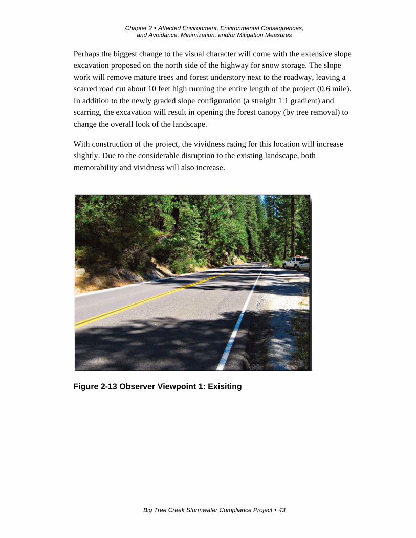
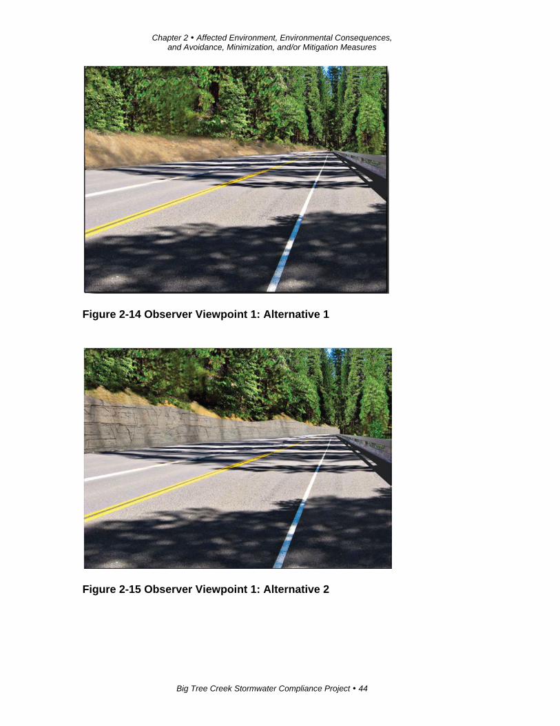
Observer Viewpoint 1 (OV-1)
Observer Viewpoint 1 shows a segment of State Route 4 that is typical within the
project area. This view represents the visual character of the landscape where existing
cut slopes are visible and partially vegetated next to the roadway and set against the
mountain forest backdrop (see Figures 2-13, 2-14 and 2-15).
Observer Viewpoint 1 is rated moderately high for existing visual quality. This view
earns its highest ratings for visual unity because of the harmonious aesthetic pattern
created by the dense forest vegetation overlaying the mountain topography. The
height of the existing cut slopes appears balanced with the existing mature trees,
scattered understory, and rock outcroppings.
Additional visual qualities are noted in the riparian vegetation of Big Tree Creek. The
intactness of this view is high, though somewhat reduced by the excavated side slopes
and existing roadway surface. The vividness of the view is average to moderately
high due to the presence of Big Tree Creek riparian habitat, which provides increased
memorability.
With implementation of the project, the visual quality rating from this viewpoint will
be reduced considerably. Both unity and intactness will be lowered due to the
introduction of hardscape elements such as retaining walls, the continuous traffic
barrier, and increased roadway paving and related elements.
Chapter 2 Affected Environment, Environmental Consequences, and Avoidance, Minimization, and/or Mitigation Measures
Big Tree Creek Stormwater Compliance Project 43
Perhaps the biggest change to the visual character will come with the extensive slope
excavation proposed on the north side of the highway for snow storage. The slope
work will remove mature trees and forest understory next to the roadway, leaving a
scarred road cut about 10 feet high running the entire length of the project (0.6 mile).
In addition to the newly graded slope configuration (a straight 1:1 gradient) and
scarring, the excavation will result in opening the forest canopy (by tree removal) to
change the overall look of the landscape.
With construction of the project, the vividness rating for this location will increase
slightly. Due to the considerable disruption to the existing landscape, both
memorability and vividness will also increase.
Figure 2-13 Observer Viewpoint 1: Exisiting
Chapter 2 Affected Environment, Environmental Consequences, and Avoidance, Minimization, and/or Mitigation Measures
Big Tree Creek Stormwater Compliance Project 44
Figure 2-14 Observer Viewpoint 1: Alternative 1
Figure 2-15 Observer Viewpoint 1: Alternative 2
Chapter 2 Affected Environment, Environmental Consequences, and Avoidance, Minimization, and/or Mitigation Measures
Big Tree Creek Stormwater Compliance Project 45
Observer Viewpoint 2 (OV-2)
Observer Viewpoint 2 overlooks the project from within the state park. This view
represents the typical scene from about five North Grove camping sites looking
toward the Big Tree Creek riparian area and beyond to the forested mountainside
across State Route 4. From this viewpoint, the highway blends well with the existing
natural surroundings and is virtually unseen. Except for the sounds of passing
vehicles, one will not even perceive that a highway was near.
The ratings indicate that this landscape unit has a moderately high visual quality. At
this location, the vividness rating is the lowest of the three rating criteria because the
landscape is fairly typical and not considered memorable to the viewer. The visual
continuity of the forest along the park edge and the freedom from encroaching
nonconforming elements result in a high intactness and unity rating for this
viewpoint.
With implementation of the project, the visual quality rating for this viewpoint will be
reduced considerably. Like Observer Viewpoint 1, both unity and intactness will be
lower because of the introduction of hardscape elements such as retaining walls, the
continuous traffic barrier, and increased roadway paving and related elements. From
this viewpoint (see note below) and because this viewer location faces the project site,
it is expected that viewers will be highly sensitive to the proposed construction, with
introduction of stark nonconforming project elements in the foreground and
engineered side slopes in the middle-ground beyond the retaining structures. As for
the structures, it is expected that only one of the five proposed retaining walls will be
visible to campers. The other four walls will be visible to only the hikers on new trails
on the southern side and upslope from Big Tree Creek.
Because of the campground proximity to the construction site and the extended
potential viewing duration by the park users, the vividness rating is expected to rise
based on the perceived visual memorability to the changes in landscape character.
Note: Currently, views of the highway from the adjacent campsites are substantially
restricted by several large fallen trees.
Chapter 2 Affected Environment, Environmental Consequences, and Avoidance, Minimization, and/or Mitigation Measures
Big Tree Creek Stormwater Compliance Project 46
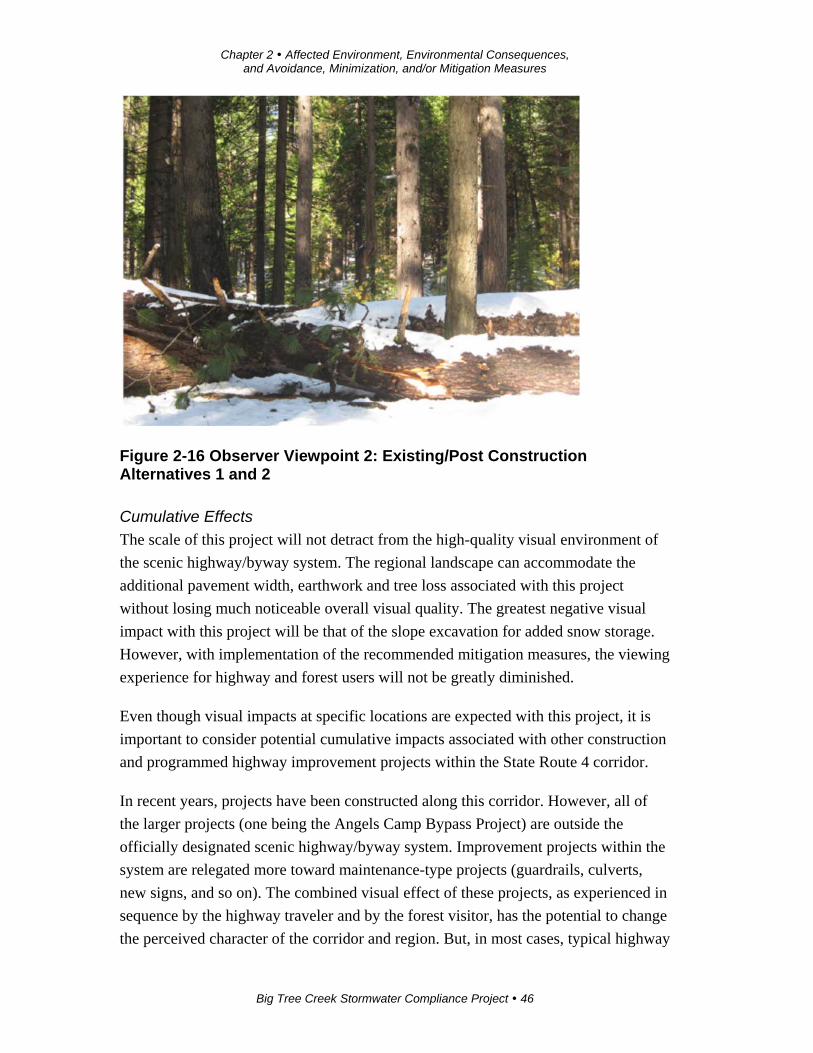
Figure 2-16 Observer Viewpoint 2: Existing/Post Construction Alternatives 1 and 2
Cumulative Effects
The scale of this project will not detract from the high-quality visual environment of
the scenic highway/byway system. The regional landscape can accommodate the
additional pavement width, earthwork and tree loss associated with this project
without losing much noticeable overall visual quality. The greatest negative visual
impact with this project will be that of the slope excavation for added snow storage.
However, with implementation of the recommended mitigation measures, the viewing
experience for highway and forest users will not be greatly diminished.
Even though visual impacts at specific locations are expected with this project, it is
important to consider potential cumulative impacts associated with other construction
and programmed highway improvement projects within the State Route 4 corridor.
In recent years, projects have been constructed along this corridor. However, all of
the larger projects (one being the Angels Camp Bypass Project) are outside the
officially designated scenic highway/byway system. Improvement projects within the
system are relegated more toward maintenance-type projects (guardrails, culverts,
new signs, and so on). The combined visual effect of these projects, as experienced in
sequence by the highway traveler and by the forest visitor, has the potential to change
the perceived character of the corridor and region. But, in most cases, typical highway

Chapter 2 Affected Environment, Environmental Consequences, and Avoidance, Minimization, and/or Mitigation Measures
Big Tree Creek Stormwater Compliance Project 47
elements (signs, guardrails, and other accessories) become commonplace and go
virtually unnoticed by the viewer.
Once the project is in place and its mitigation measures have been implemented and
have become established, only highway users most familiar with this section of the
highway will perceive that it has been changed. Frequent park users will share similar
sensitivity to visual change from within the park. But, the softening effect of the
proposed mitigation measures will act to absorb the visual impacts caused by
construction and help restore the visual character and quality of the area.
Overall, qualities that make this highway visually enjoyable will outweigh the
negative effects of the proposed changes. Retaining walls and cut slopes are expected
visual features within mountainous highway areas, and they already exist along this
highway in other locations. Cumulatively, the overall high quality of the visual
experience along the highway corridor will not be lessened.
The potential cumulative impacts along this scenic route should continue to be
assessed, and it is recommended that the effects of this project be considered as part
of the analysis of future projects.
Avoidance, Minimization, and/or Mitigation Measures
To maintain the elements of visual quality and decrease the amount of negative visual
impact caused by the project, the following design, construction and maintenance
actions are recommended. With implementation of these mitigation methods, the
visual impacts of this project can be reduced and will not result in significant changes
in overall visual quality.
1. Use contour grading to simulate the natural undulating slope forms found
within the regional landscape to reduce an engineered appearance. Slope
rounding should be implemented in all cases.
2. Where possible, avoid extreme modification of topographic features.
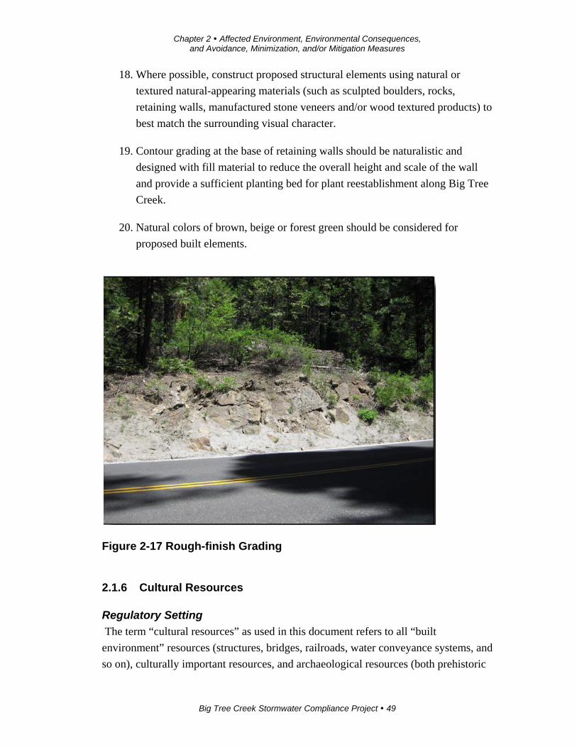
3. Overall, finish slope grading with a rough appearance to create a naturally
aged look (see Figure 2-17).
4. Where possible, retain existing (naturally occurring) rock outcroppings. When
safe, allow isolated boulders and partially excavated rock to remain and
protrude from the slope face.
Chapter 2 Affected Environment, Environmental Consequences, and Avoidance, Minimization, and/or Mitigation Measures
Big Tree Creek Stormwater Compliance Project 48
5. If possible, stockpile excavated boulders, and place them randomly back into
the landscape.
6. Treat rock outcroppings that are exposed during construction with stain
treatment to give a weathered appearance.
7. Where possible, flatten slopes in locations where trees do not exist. In no case
should excavation be performed in proximity to a tree where the end result
leaves exposed tree roots. If tree roots are exposed, the tree should be
completely removed.
8. As much as possible, excavate slopes to minimize tree removal.
9. Revegetate all disturbed soil areas after recontouring the landform.
10. Replace removed trees and understory where possible.
11. Replant with native species as much as possible. The Caltrans District
Biologist and Landscape Architect shall work with the Calaveras Big Trees
State Park biologist to determine appropriate revegetation species.
12. Undulate or feather the perimeter of tree groupings to increase the natural
appearance.
13. Vary plant spacing for a more natural appearance.
14. Where possible to implement, save appropriate number of felled trees and
boulders and naturally place them at random locations on disturbed areas to
create an aged appearance, as determined by the Caltrans Landscape
Architecture Department.
15. Collect, stockpile, and reapply duff to the excavated slopes to reduce the
newly constructed look and to promote natural revegetation.
16. Apply erosion control to all disturbed soil areas.
17. Erosion control seed species, origin and application strategy shall be
determined by Caltrans Landscape Architects in consultation with Caltrans
District Biologists, and Calaveras Big Trees State Park.
Chapter 2 Affected Environment, Environmental Consequences, and Avoidance, Minimization, and/or Mitigation Measures
Big Tree Creek Stormwater Compliance Project 49
18. Where possible, construct proposed structural elements using natural or
textured natural-appearing materials (such as sculpted boulders, rocks,
retaining walls, manufactured stone veneers and/or wood textured products) to
best match the surrounding visual character.
19. Contour grading at the base of retaining walls should be naturalistic and
designed with fill material to reduce the overall height and scale of the wall
and provide a sufficient planting bed for plant reestablishment along Big Tree
Creek.
20. Natural colors of brown, beige or forest green should be considered for
proposed built elements.
Figure 2-17 Rough-finish Grading
2.1.6 Cultural Resources
Regulatory Setting
The term “cultural resources” as used in this document refers to all “built
environment” resources (structures, bridges, railroads, water conveyance systems, and
so on), culturally important resources, and archaeological resources (both prehistoric
Chapter 2 Affected Environment, Environmental Consequences, and Avoidance, Minimization, and/or Mitigation Measures
Big Tree Creek Stormwater Compliance Project 50
and historic), regardless of significance. Laws and regulations dealing with cultural
resources include the following.
The National Historic Preservation Act of 1966, as amended sets forth national policy
and procedures regarding historic properties, defined as districts, sites, buildings,
structures, and objects included in or eligible for the National Register of Historic
Places. Section 106 of National Historic Preservation Act of 1966 requires federal
agencies to take into account the effects of their undertakings on such properties and
to allow the Advisory Council on Historic Preservation the opportunity to comment
on those undertakings, following regulations issued by the Advisory Council on
Historic Preservation (36 Code of Federal Regulations 800).
On January 1, 2004, a Section 106 Programmatic Agreement (PA) between the
Advisory Council, the Federal Highway Administration, State Historic Preservation
Officer, and Caltrans went into effect for Department projects, both state and local,
with Federal Highway Administration involvement. The Programmatic Agreement
implements the Advisory Council’s regulations, 36 Code of Federal Regulations 800,
streamlining the Section 106 process and delegating certain responsibilities to
Caltrans. The Federal Highway Administration’s responsibilities under the
Programmatic Agreement have been assigned to Caltrans as part of the Surface
Transportation Project Delivery Program (23 U.S. Code 327).
The Archaeological Resources Protection Act (ARPA) applies when a project may
involve archaeological resources located on federal or tribal land. This act requires
that a permit be obtained before excavation of an archaeological resource on such
land can take place.
Historic properties may also be covered under Section 4(f) of the U.S. Department of
Transportation Act, which regulates the “use” of land from historic properties. See
Appendix B for specific information on Section 4(f).
Historical resources are considered under the California Environmental Quality Act,
as well as California Public Resources Code Section 5024.1, which established the
California Register of Historical Resources. Public Resources Code Section 5024
requires state agencies to identify and protect state-owned resources that meet
National Register of Historic Places listing criteria. It further specifically requires
Caltrans to inventory state-owned structures in its rights-of-way. Sections 5024(f) and
5024.5 require state agencies to provide notice to and consult with the State Historic
Preservation Officer before altering, transferring, relocating, or demolishing state-
Chapter 2 Affected Environment, Environmental Consequences, and Avoidance, Minimization, and/or Mitigation Measures
Big Tree Creek Stormwater Compliance Project 51
owned historical resources that are listed on or are eligible for inclusion in the
National Register or are registered or eligible for registration as California Historical
Landmarks.
Affected Environment
A Historic Property Survey Report was completed for this project in December 2013.
Caltrans conducted a cultural resources inventory of historical and archaeological
resources in the project area. One archaeological resource and one historic-era
property were documented within the boundary of archaeological site CA-CAL-
277/H.
An extended Phase I archaeological study was done to determine: 1) the presence or
absence of subsurface archaeological materials, and 2) the archaeological site
boundaries within the area of potential effects, which includes the entirety of the
existing state right-of-way and an additional 30 feet beyond the current right-of-way.
The maximum vertical area of potential effects is 12 feet below original ground at the
cut-zone on the north side of State Route 4. The minimum vertical area of potential
effects is 4 feet for the retaining walls. The current area of potential effects includes
all known construction easements and staging areas. The area of potential effects
encompasses approximately 10 acres.
Later Phase II archaeological testing determined: 1) further subsurface
materials/boundaries, 2) integrity of deposits, and 3) analysis of materials recovered
to determine whether CA-CAL-277/H is eligible for listing in the National Register of
Historic Places. A Historic Property Survey Report was completed and submitted
with the Eligibility Report to the State Historic Preservation Officer for concurrence
of eligibility for CA-CAL-277/H.
The prehistoric component of CA-CAL-277/H was found eligible for inclusion in the
National Register of Historic Places under Criterion D because it has yielded, or is
likely to yield, information important in prehistory or history. This site is a large
prehistoric site with a historic-era property on the southeastern portion of the site
boundary. The site measures roughly 810 feet east-west paralleling and on either side
of State Route 4. The site has nine bedrock milling stations in three locations,
featuring a diverse assemblage of tools and debris. Included were obsidian and waste
material from tool making, which can be used for carbon dating.
Chapter 2 Affected Environment, Environmental Consequences, and Avoidance, Minimization, and/or Mitigation Measures
Big Tree Creek Stormwater Compliance Project 52
Identification of historic properties involved review and study of pertinent literature,
historic property listings, and appropriate inventories and databases, as well as
research at local, regional, and state archives, including California State Parks
archives. Additional cultural resources studies targeted the potential for proposed
retaining walls to result in direct or indirect effects to historic properties due to loss of
views or to construction-related, ground-borne vibration.
The historic component is a pump house built in about 1935 by the Civilian
Conservation Corps. The pump house has been identified, formally evaluated and
determined to be eligible for the National Register of Historic Places.
Caltrans concluded that the pump house and related well in accordance with Section
15064.5 (a)(2)-(3) of the California Environmental Quality Act Guidelines, using
criteria outlined in Section 5024.1 of the California Public Resources Code, were
historical resources for the purposes of the California Environmental Quality Act. The
State Historic Preservation Officer concurred with the eligibility determination on
January 23, 2014.
Environmental Consequences
Both build alternatives would directly affect archaeological site CA-CAL-277/H.
Construction activities would affect the contributing archaeological components of
each spot. The pump house is located within the boundaries of CA-CAL-227/H.
Construction activities such as cut-and-fill, grading, and tree removal would affect
both areas, as determined by the Phase II archaeological study. This study was done
to determine if the site was eligible for the National Register of Historic Places. The
project would adversely affect the two intact portions of CA-CAL-277/H. The pump
house, which is located within the area of potential effects but outside of the area of
direct impact, would not be affected by either build alternative.
CA-CAL-227/H is not a Section 4(f) resource, as it is the pre-historic component is
eligible under Criterion D (value for data). The pump house is eligible under criteria
C (architecture) but would not be affected by project. The park in which the site sits is
a Section 4(f) property.
The State Historic Preservation Officer concurred with the eligibility determination
on January 23, 2014.
Chapter 2 Affected Environment, Environmental Consequences, and Avoidance, Minimization, and/or Mitigation Measures
Big Tree Creek Stormwater Compliance Project 53
Avoidance, Minimization, and/or Mitigation Measures
Caltrans has incorporated two design exceptions to minimize impacts to the cultural
sites.
Caltrans completed the Memorandum of Agreement on January 12, 2014. The
following provisions were agreed to:
Implementation of the Historic Treatment Plan (September 20014) to preserve
and protect affect elements of the historic site.
Environmentally sensitive fencing will be placed around portions of the
archeology site that is not being affected directly by construction.
Archaeological monitoring by an archaeologist trained in human osteology
and a Native American monitor during ground-disturbing activities at the
following locations:
o The area within the proposed right-of-way between the western and
eastern boundaries of locus 2 of the archaeological site.
o The area within the proposed right-of-way between the western and
eastern boundaries of locus 1 of the archaeological site.
o The area within the proposed right-of-way between the western and
eastern boundaries of locus 3 of the archaeological site.
Cultural resource sensitivity training will be required for all personnel
working on the project during construction. Participating Native American
members shall deliver a cultural resources sensitivity training video for use
when an archaeologist and Native American monitor are not available to
deliver training.
An agreement between interested Native American Tribes and Caltrans for the
final treatment of the two bedrock milling station features of the
archaeological site will be developed for review, comment, and
implementation.
Caltrans will, with the coordination of the participating Tribes of Calaveras
Band of the Mi-Wuk, Washoe Tribe of Nevada and California, and Miwok,
Chapter 2 Affected Environment, Environmental Consequences, and Avoidance, Minimization, and/or Mitigation Measures
Big Tree Creek Stormwater Compliance Project 54
develop a monitoring agreement and treatment of the bedrock milling station
feature.
It is Caltrans’ policy to avoid cultural resources whenever possible. If buried cultural
materials are encountered during construction, it is Caltrans’ policy to stop work in
the area until a qualified archaeologist can evaluate the nature and significance of the
find.
If human remains are discovered, State Health and Safety Code Section 7050.5 states
that further disturbances and activities shall cease in any area or nearby area
suspected to overlie remains, and the County Coroner contacted. Pursuant to
California Public Resources Code Section 5097.98, if the remains are thought to be
Native American, the coroner will notify the Native American Heritage Commission,
which will then notify the Most Likely Descendent. At this time, the person who
discovered the remains would contact the Resident Engineer so that he or she could
work with the Most Likely Descendent on the respectful treatment and disposition of
the remains. Further provisions of Public Resources Code 5097.98 are to be followed
as applicable.
2.2 Physical Environment
2.2.1 Water Quality and Stormwater Runoff
Regulatory Setting
Federal Requirements: Clean Water Act
In 1972, Congress amended the Federal Water Pollution Control Act, making the
addition of pollutants to the waters of the United States from any point source
unlawful unless the discharge is in compliance with a National Pollutant Discharge
Elimination System (NPDES) permit. The act is known today as the Clean Water Act,
and Congress has amended it several times. In the 1987 amendments, Congress
directed dischargers of stormwater from municipal and industrial/construction point
sources to comply with the National Pollutant Discharge Elimination System permit
requirements.
Important Clean Water Act sections are the following:
Sections 303 and 304 require states to put forth water quality standards,
criteria, and guidelines.

Chapter 2 Affected Environment, Environmental Consequences, and Avoidance, Minimization, and/or Mitigation Measures
Big Tree Creek Stormwater Compliance Project 55
Section 401 requires an applicant for a federal license or permit to conduct
any activity that may result in a discharge to waters of the United States to
obtain certification from the state that the discharge will comply with other
provisions of the act. This is most frequently required in tandem with a
Section 404 permit request (see below).
Section 402 establishes the National Pollutant Discharge Elimination System,
a permitting system for the discharges (except for dredge or fill material) of
any pollutant into waters of the United States. Regional Water Quality Control
Boards (regional water boards) administer this permitting program in
California. Section 402(p) requires permits for discharges of stormwater from
industrial/construction and municipal separate storm sewer systems (known as
MS4s).
Section 404 establishes a permit program for the discharge of dredge or fill
material into waters of the United States. This permit program is administered
by the U.S. Army Corps of Engineers.
The objective of the Clean Water Act is to restore and maintain the chemical,
physical, and biological integrity of the nation’s waters.
The U.S. Army Corps of Engineers issues two types of 404 permits: general permits
and standard permits.
There are two types of general permits: regional permits and nationwide permits.
Regional permits are issued for a general category of activities when they are similar
in nature and cause minimal environmental effect. Nationwide permits are issued to
authorize a variety of minor project activities with no more than minimal effects.
There are two types of standard 404 permits: individual permits and letters of
permission. Ordinarily, projects that do not meet the criteria for a nationwide permit
may be permitted under one of U.S. Army Corps of Engineers’ standard permits. For
standard permits, the U.S. Army Corps of Engineers’ decision to approve is based on
compliance with the U.S. Environmental Protection Agency’s Section 404 (b)(1)
Guidelines (U.S. EPA Code of Federal Regulations 40 Part 230), and whether permit
approval is in the public interest.
The Section 404(b)(1) Guidelines were developed by the U.S. EPA in conjunction
with the U.S. Army Corps of Engineers. They allow the discharge of dredged or fill
Chapter 2 Affected Environment, Environmental Consequences, and Avoidance, Minimization, and/or Mitigation Measures
Big Tree Creek Stormwater Compliance Project 56
material into the aquatic system (waters of the United States) only if there is no
practicable alternative that will have less adverse effects. The guidelines state that the
U.S. Army Corps of Engineers may not issue a permit if there is a least
environmentally damaging practicable alternative (LEDPA) to the proposed discharge
that will have lesser effects on waters of the United States, and not have any other
significant adverse environmental consequences.
According to the guidelines, documentation is needed that a sequence of avoidance,
minimization, and compensation measures has been followed, in that order. The
guidelines also restrict permitting activities that violate water quality or toxic effluent
standards, jeopardize the continued existence of listed species, violate marine
sanctuary protections, or cause “significant degradation” to waters of the United
States. In addition, every permit from the U.S. Army Corps of Engineers, even if not
subject to the Section 404(b)(1) Guidelines, must meet general requirements. See 33
Code of Federal Regulations 320.4.
A discussion of the least environmentally damaging practicable alternative
determination is not required for this project because wetlands are not being affected.
State Requirements: Porter-Cologne Water Quality Control Act
California’s Porter-Cologne Act, enacted in 1969, provides the legal basis for water
quality regulation within California. This act requires a “Report of Waste Discharge”
for any discharge of waste (liquid, solid, or gaseous) to land or surface waters that
may impair beneficial uses for surface and/or groundwater of the state. It predates the
Clean Water Act and regulates discharges to waters of the state. Waters of the state
include more than just waters of the United States, like groundwater and surface
waters not considered waters of the United States. Also, the act prohibits discharges
of “waste” as defined; this definition is broader than the Clean Water Act definition
of “pollutant.” Discharges under the Porter-Cologne Act are permitted by waste
discharge requirements (WDRs) and may be required even when the discharge is
already permitted or exempt under the Clean Water Act.
The State Water Resources Control Board (the State Board) and regional water
boards are responsible for establishing the water quality standards (objectives and
beneficial uses) required by the Clean Water Act and regulating discharges to ensure
compliance with the water quality standards. Details on water quality standards in a
project area are contained in the applicable regional water board’s Basin Plan.

Chapter 2 Affected Environment, Environmental Consequences, and Avoidance, Minimization, and/or Mitigation Measures
Big Tree Creek Stormwater Compliance Project 57
In California, regional boards designate beneficial uses for all water body segments in
their jurisdictions and then set criteria necessary to protect these uses. Consequently,
the water quality standards developed for particular water segments are based on the
designated use and vary depending on such use. In addition, the State Board identifies
waters failing to meet standards for specific pollutants, which are then state-listed in
accordance with Clean Water Act Section 303(d).
If a state determines that waters are impaired for one or more constituents and the
standards cannot be met through point source or non-point source controls (National
Pollutant Discharge Elimination System permits or waste discharge requirements),
the act requires the establishment of total maximum daily loads (TMDLs), which
specify allowable pollutant loads from all sources (point, non-point, and natural) for a
given watershed.
State Water Resources Control Board and Regional Water Quality Control
Boards
The State Board administers water rights, sets water pollution control policy, issues
water board orders on matters of statewide application, and oversees water quality
functions throughout the state by approving basin plans, total maximum daily loads,
and National Pollutant Discharge Elimination System permits. Regional water boards
are responsible for protecting beneficial uses of water resources within their regional
jurisdiction using planning, permitting, and enforcement authorities to meet this
responsibility.
National Pollutant Discharge Elimination System (NPDES) Program
Municipal Separate Storm Sewer Systems (MS4)
Section 402(p) of the Clean Water Act requires the issuance of National Pollutant
Discharge Elimination System permits for five categories of stormwater discharges,
including Municipal Separate Storm Sewer Systems (known as MS4s). The U.S. EPA
defines an MS4 as “any conveyance or system of conveyances (roads with drainage
systems, municipal streets, catch basins, curbs, gutters, ditches, human-made
channels, and storm drains) owned or operated by a state, city, town, county, or other
public body having jurisdiction over stormwater, that are designed or used for
collecting or conveying stormwater.” The State Board has identified Caltrans as an
owner/operator of an MS4 pursuant to federal regulations. Caltrans’s MS4 permit
covers all Department rights-of-way, properties, facilities, and activities in the state.
Chapter 2 Affected Environment, Environmental Consequences, and Avoidance, Minimization, and/or Mitigation Measures
Big Tree Creek Stormwater Compliance Project 58
The State Board or the regional water boards issue National Pollutant Discharge
Elimination System permits for five years; permit requirements remain active until a
new permit has been adopted.
Caltrans’s MS4 permit, under revision at the time of this update, contains three basic
requirements:
1. Caltrans must comply with the requirements of the Construction General
Permit (see below).
2. Caltrans must implement a year-round program in all parts of the state to
effectively control stormwater and non-stormwater discharges.
3. Caltrans’ stormwater discharges must meet water quality standards
through implementation of permanent and temporary (construction) best
management practices (BMPs), to the maximum extent practicable, and
other measures as the State Board determines to be necessary to meet the
water quality standards.
To comply with the permit, Caltrans developed the Statewide Stormwater
Management Plan (SWMP) to address stormwater pollution controls related to
highway planning, design, construction, and maintenance activities throughout
California. The Statewide Stormwater Management Plan assigns responsibilities
within Caltrans for implementing stormwater management procedures and practices
as well as training, public education and participation, monitoring and research,
program evaluation, and reporting activities. The Statewide Stormwater Management
Plan describes the minimum procedures and practices Caltrans uses to reduce
pollutants in stormwater and non-stormwater discharges. It outlines procedures and
responsibilities for protecting water quality, including the selection and
implementation of best management practices. The proposed project will be
programmed to follow the guidelines and procedures outlined in the latest Statewide
Stormwater Management Plan to address stormwater runoff.
Construction General Permit
The Construction General Permit (Order No. 2009-009-DWQ, as amended by 2010-
0014-DWG), adopted on November 16, 2010, became effective on February 14,
2011. The permit regulates stormwater discharges from construction sites that result
in a disturbed soil area of 1 acre or greater, and/or are smaller sites that are part of a
larger common plan of development. By law, all stormwater discharges associated
Chapter 2 Affected Environment, Environmental Consequences, and Avoidance, Minimization, and/or Mitigation Measures
Big Tree Creek Stormwater Compliance Project 59
with construction activity where clearing, grading, and excavation results in soil
disturbance of at least 1 acre must comply with the provisions of the General
Construction Permit. Construction activity that results in soil disturbances of less than
1 acre is subject to this Construction General Permit if there is potential for
significant water quality impairment resulting from the activity as determined by the
regional water board. Operators of regulated construction sites are required to develop
stormwater pollution prevention plans; implement sediment, erosion, and pollution
prevention control measures; and obtain coverage under the Construction General
Permit.
The 2011 Construction General Permit separates projects into risk levels 1, 2, and 3.
Risk levels are determined during the planning and design phases. They are based on
potential erosion and transport to receiving waters. Requirements apply according to
the risk level determined. For example, a risk level 3 (highest risk) project will
require compulsory stormwater runoff pH and turbidity monitoring, plus before-
construction and after-construction aquatic biological assessments during specified
seasonal windows. For all projects subject to the permit, applicants are required to
develop and implement an effective Stormwater Pollution Prevention Plan (SWPPP).
In accordance with Caltrans’s standard specifications, a Water Pollution Control Plan
(WPCP) is necessary for projects with disturbed soil area less than 1 acre.
Section 401 Permitting
Under Section 401 of the Clean Water Act, any project requiring a federal license or
permit that may result in a discharge to a water of the United States must obtain a 401
Certification, which certifies that the project will be in compliance with state water
quality standards. The most common federal permits triggering 401 Certification are
Clean Water Act Section 404 permits issued by the U.S. Army Corps of Engineers.
The 401 permit certifications are obtained from the appropriate regional water boards,
depending on the project location, and are required before the U.S. Army Corps of
Engineers issues a 404 permit.
In some cases, the regional water boards may have specific concerns with discharges
associated with a project. As a result, the regional water boards may issue a set of
requirements known as waste discharge requirements (WDRs) under the State Water
Code (Porter-Cologne Act) that define activities, such as the inclusion of specific
features, effluent limitations, monitoring, and plan submittals that are to be
implemented for protecting or benefiting water quality. The waste discharge
Chapter 2 Affected Environment, Environmental Consequences, and Avoidance, Minimization, and/or Mitigation Measures
Big Tree Creek Stormwater Compliance Project 60
requirements can be issued to address both permanent and temporary discharges of a
project.
Affected Environment
An Air, Water, and Noise Report for the project was completed in July 2013.
The project area sits within the Upper Calaveras Hydrologic Unit 33.30. Big Tree
Creek is the main water body in the project area.
In this area, Caltrans uses sand to provide traction and de-icing to reduce snow and
ice. When Caltrans maintenance crews clear snow from State Route 4, their snow
blowers displace the sand along with the snow over the side of State Route 4 to the
bank above Big Tree Creek. When the snow melts, the sand drops into Big Tree
Creek.
Environmental Consequences
By following best management practices during construction, the proposed project
will not have adverse effects on surface water or groundwater.
The project will remove a non-standard pollution source and address a violation of
the National Pollutant Discharge Elimination System and Caltrans Stormwater
Management Plan. Once constructed, the project will reduce the amount of sand
getting into Big Tree Creek from snowmelt runoff.
Avoidance, Minimization, and/or Mitigation Measures
Best management practices will be required because a soil disturbance area greater
than 1 acre is anticipated. The following will be required:
A notice of intention will be submitted to the appropriate regional water
quality control board at least 30 days prior to start of construction.
A stormwater pollution prevention plan will be prepared and implemented
during construction to the satisfaction of resident engineer. The plan will be
approved by Caltrans prior to start of construction. Caltrans will then submit
the plan to the Regional Water Quality Board for approval.
A notice of termination shall be submitted to the regional water quality control
board on completion of construction and site stabilization. A project will be
considered complete when the criteria for final stabilization defined in the
construction general board permit are met.
Chapter 2 Affected Environment, Environmental Consequences, and Avoidance, Minimization, and/or Mitigation Measures
Big Tree Creek Stormwater Compliance Project 61
2.3 Biological Environment
2.3.1 Natural Communities
This section of the document discusses natural communities of concern. The focus of
this section is on biological communities, not individual plant or animal species.
Wildlife corridors are areas of habitat used by wildlife for seasonal or daily migration.
Habitat fragmentation involves the potential for dividing sensitive habitat and thereby
lessening its biological value.
Wetlands and other waters are discussed below in Section 2.3.2.
Affected Environment
A Natural Environment Study for the project was completed in December 2013.
Two natural communities in the study area would be affected by the project: riparian
habitat along Big Tree Creek and montane hardwood conifer. Neither of these is
considered a critical habitat under the Federal Endangered Species Act.
Riparian
Riparian habitat is the area surrounding bodies of fresh water, such as creeks, rivers
and streams. A narrow corridor of riparian habitat is present along Big Tree Creek,
both within the project area and elsewhere. The canopy within this riparian corridor
consists mostly of two species: Pacific dogwood and white alder. The understory
consists of plant species such as the common yellow monkeyflower, western bracken
fern, corn lily, and stream boykinia. Conifers are scattered within this riparian zone.
Montane Hardwood Conifer
Montane hardwood conifer habitat hosts and supports a variety of wildlife species.
Mature forests are valuable to cavity-nesting birds, with acorns and pine nuts an
important food source for many mammals as well as birds. Canopy cover and
understory vegetation vary, which makes the habitat suitable for many species.
Conifer seeds and needles, bark, acorns, and the leaves and berries of various
evergreen shrubs provide food for animals that are active during the winter such as
the western gray squirrel, deer mouse, American porcupine, mountain quail, mountain
chickadee, golden-crowned kinglet, brown creeper, and red-breasted nuthatch.
This habitat supports hardwoods such as black oak (Quercus kelloggii) and conifers
such as ponderosa pine, incense-cedar, sugar pine, and white fir. Shrubs within the
project area consist of greenleaf manzanita, mountain whitethorn, and deerbrush.
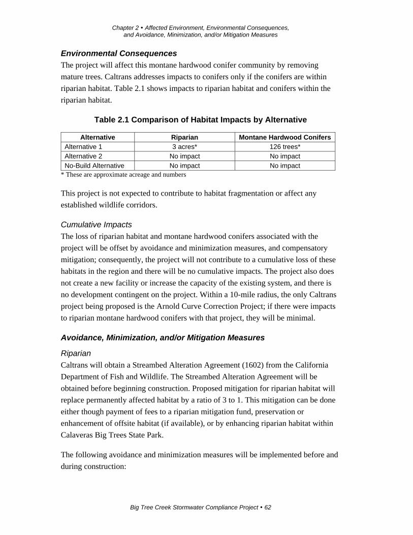
Chapter 2 Affected Environment, Environmental Consequences, and Avoidance, Minimization, and/or Mitigation Measures
Big Tree Creek Stormwater Compliance Project 62
Environmental Consequences
The project will affect this montane hardwood conifer community by removing
mature trees. Caltrans addresses impacts to conifers only if the conifers are within
riparian habitat. Table 2.1 shows impacts to riparian habitat and conifers within the
riparian habitat.
Table 2.1 Comparison of Habitat Impacts by Alternative
Alternative Riparian Montane Hardwood Conifers Alternative 1 3 acres* 126 trees*
Alternative 2 No impact No impact
No-Build Alternative No impact No impact * These are approximate acreage and numbers
This project is not expected to contribute to habitat fragmentation or affect any
established wildlife corridors.
Cumulative Impacts
The loss of riparian habitat and montane hardwood conifers associated with the
project will be offset by avoidance and minimization measures, and compensatory
mitigation; consequently, the project will not contribute to a cumulative loss of these
habitats in the region and there will be no cumulative impacts. The project also does
not create a new facility or increase the capacity of the existing system, and there is
no development contingent on the project. Within a 10-mile radius, the only Caltrans
project being proposed is the Arnold Curve Correction Project; if there were impacts
to riparian montane hardwood conifers with that project, they will be minimal.
Avoidance, Minimization, and/or Mitigation Measures
Riparian
Caltrans will obtain a Streambed Alteration Agreement (1602) from the California
Department of Fish and Wildlife. The Streambed Alteration Agreement will be
obtained before beginning construction. Proposed mitigation for riparian habitat will
replace permanently affected habitat by a ratio of 3 to 1. This mitigation can be done
either though payment of fees to a riparian mitigation fund, preservation or
enhancement of offsite habitat (if available), or by enhancing riparian habitat within
Calaveras Big Trees State Park.
The following avoidance and minimization measures will be implemented before and
during construction:

Chapter 2 Affected Environment, Environmental Consequences, and Avoidance, Minimization, and/or Mitigation Measures
Big Tree Creek Stormwater Compliance Project 63
Limit removal of riparian vegetation to the minimum amount necessary to
allow for efficient project construction.
Minimize the amount of riparian vegetation removed by installing
environmentally sensitive area fencing at the outer edge of the work area on
the south side of State Route 4 before any ground disturbance or other
construction-related activities. The fencing will be clearly delineated on the
final contract plans. Any encroachment beyond the fencing will be prohibited.
The project’s special provision package will provide clear language regarding
acceptable fencing material and prohibited construction-related activities,
vehicle operation, material and equipment storage, and other surface-
disturbance activities within sensitive areas.
Montane Hardwood Conifer
The following avoidance and minimization measures will be implemented before and
during construction:
Limit removal of conifer habitat to the minimum necessary to allow for efficient
project construction.
Install high-visibility fencing outside of the drip line of the vegetation adjacent to
the work areas within this habitat to make clear the environmentally sensitive
area. Any encroachment beyond the environmentally sensitive area fencing
during construction will be prohibited. The environmentally sensitive area
fencing will be clearly delineated on the final contract plans. The project’s
special provision package will provide clear language regarding acceptable
fencing material and prohibited construction-related activities, vehicle operation,
material and equipment storage, and other surface-disturbance activities within
sensitive areas.
2.3.2 Wetlands and Other Waters
Regulatory Setting
Wetlands and other waters are protected under a number of laws and regulations. At
the federal level, the Federal Water Pollution Control Act, more commonly referred
to as the Clean Water Act (33 U.S. Code 1344), is the main law regulating wetlands
and surface waters. One purpose of the Clean Water Act is to regulate the discharge
of dredged or fill material into waters of the United States, including wetlands.
Waters of the United States include navigable waters, interstate waters, territorial seas
Chapter 2 Affected Environment, Environmental Consequences, and Avoidance, Minimization, and/or Mitigation Measures
Big Tree Creek Stormwater Compliance Project 64
and other waters that may be used in interstate or foreign commerce. To classify
wetlands for the purposes of the Clean Water Act, a three-parameter approach is used
that includes the presence of: hydrophytic (water-loving) vegetation, wetland
hydrology, and hydric soils (soils formed during saturation/inundation). All three
parameters must be present, under normal circumstances, for an area to be designated
as a jurisdictional wetland under the Clean Water Act.
Section 404 of the Clean Water Act establishes a regulatory program that provides
that discharge of dredged or fill material cannot be permitted if a practicable
alternative exists that is less damaging to the aquatic environment or if the nation’s
waters will be significantly degraded. The Section 404 permit program is run by the
U.S. Army of Engineers with oversight by the U.S. Environmental Protection Agency
(U.S. EPA).
The U.S. Army Corps of Engineers issues two types of 404 permits: general permits
and standard permits. There are two types of general permits: regional permits and
nationwide permits. Regional permits are issued for a general category of activities
when they are similar in nature and cause minimal environmental effect. Nationwide
permits are issued to authorize a variety of minor project activities with no more than
minimal effects.
There are two types of standard permits: individual permits and letters of permission.
Ordinarily, projects that do not meet the criteria for a nationwide permit may be
permitted under one of the U.S. Army Corps of Engineers’ standard permits. For
standard permits, the U.S. Army Corps of Engineers’ decision to approve is based on
compliance with U.S. EPA’s Section 404(b)(1) Guidelines (U.S. EPA 40 Code of
Federal Regulations Part 230), and whether permit approval is in the public interest.
The Section 404 (b)(1) Guidelines were developed by the U.S. EPA in conjunction
with the U.S. Army Corps of Engineers, and allow the discharge of dredged or fill
material into the aquatic system (waters of the United States) only if there is no
practicable alternative which will have less adverse effects.
The guidelines state that the U.S. Army Corps of Engineers may not issue a permit if
there is a least environmentally damaging practicable alternative (LEDPA) to the
proposed discharge that will have lesser effects on waters of the United States, and
not have any other significant adverse environmental consequences.
The Executive Order for the Protection of Wetlands (Executive Order 11990) also
regulates the activities of federal agencies with regard to wetlands. Essentially, this
Chapter 2 Affected Environment, Environmental Consequences, and Avoidance, Minimization, and/or Mitigation Measures
Big Tree Creek Stormwater Compliance Project 65
order states that a federal agency, such as the Federal Highway Administration and/or
Caltrans, as assigned, cannot undertake or provide assistance for new construction
located in wetlands unless the head of the agency finds: 1) that there is no practicable
alternative to the construction and 2) the proposed project includes all practicable
measures to minimize harm.
At the state level, wetlands and waters are regulated primarily by the California
Department of Fish and Wildlife, the State Water Resources Control Board (state
board) and the Regional Water Quality Control Boards (regional water boards). In
certain circumstances, the Coastal Commission (or Bay Conservation and
Development Commission or Tahoe Regional Planning Agency) may also be
involved.
Sections 1600-1607 of the California Fish and Game Code require any agency that
proposes a project that will substantially divert or obstruct the natural flow of or
substantially change the bed or bank of a river, stream, or lake to notify the California
Department of Fish and Wildlife before beginning construction. If the California
Department of Fish and Wildlife determines that the project may substantially and
adversely affect fish or wildlife resources, a Lake or Streambed Alteration Agreement
will be required.
California Department of Fish and Wildlife jurisdictional limits are usually defined
by the tops of the stream or lake banks, or the outer edge of riparian vegetation,
whichever is wider. Wetlands under jurisdiction of the U.S. Army Corps of Engineers
may or may not be included in the area covered by a Streambed Alteration Agreement
obtained from the California Department of Fish and Wildlife.
The regional water boards were established under the Porter-Cologne Water Quality
Control Act to oversee water quality. The regional water boards also issue water
quality certifications for impacts to wetlands and waters in compliance with Section
401 of the Clean Water Act. See the Water Quality section for more details.
Affected Environment
A Natural Environment Study was done for the project in December 2013.
The biological study area, which covered the entire length of the project limits
extending out approximately 2,000 feet from the edge of the traveled way on both
sides of the road, was studied for wetlands and waters.
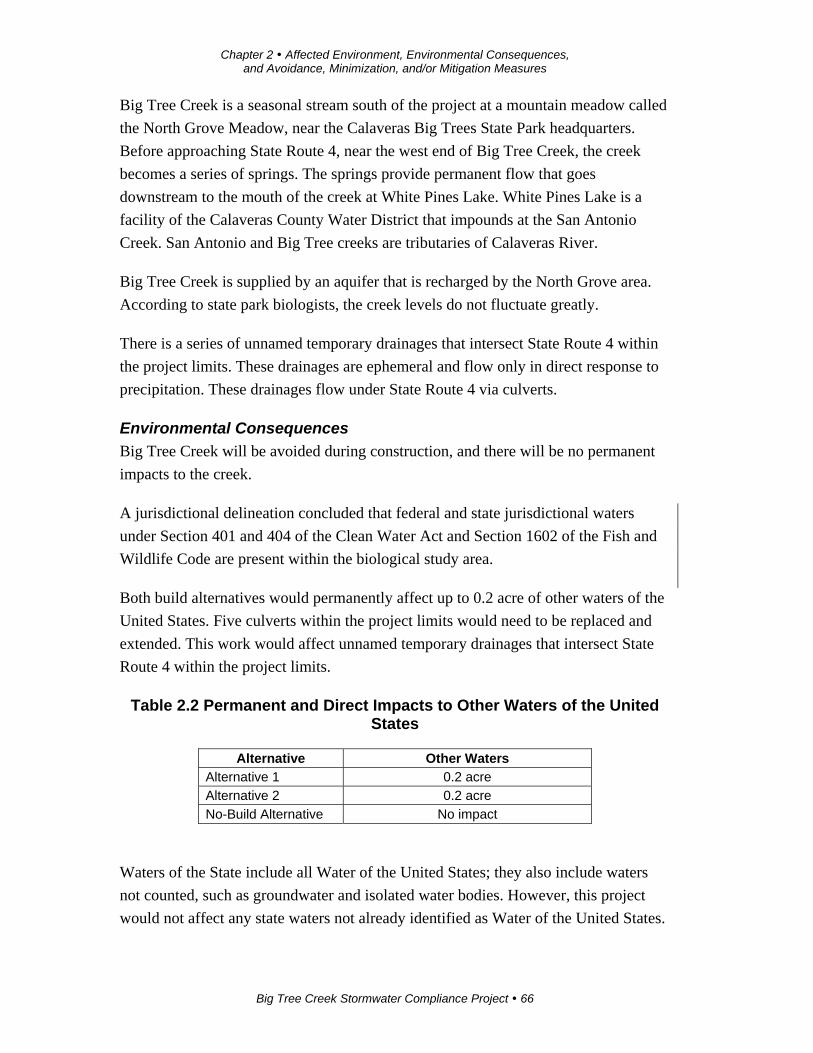
Chapter 2 Affected Environment, Environmental Consequences, and Avoidance, Minimization, and/or Mitigation Measures
Big Tree Creek Stormwater Compliance Project 66
Big Tree Creek is a seasonal stream south of the project at a mountain meadow called
the North Grove Meadow, near the Calaveras Big Trees State Park headquarters.
Before approaching State Route 4, near the west end of Big Tree Creek, the creek
becomes a series of springs. The springs provide permanent flow that goes
downstream to the mouth of the creek at White Pines Lake. White Pines Lake is a
facility of the Calaveras County Water District that impounds at the San Antonio
Creek. San Antonio and Big Tree creeks are tributaries of Calaveras River.
Big Tree Creek is supplied by an aquifer that is recharged by the North Grove area.
According to state park biologists, the creek levels do not fluctuate greatly.
There is a series of unnamed temporary drainages that intersect State Route 4 within
the project limits. These drainages are ephemeral and flow only in direct response to
precipitation. These drainages flow under State Route 4 via culverts.
Environmental Consequences
Big Tree Creek will be avoided during construction, and there will be no permanent
impacts to the creek.
A jurisdictional delineation concluded that federal and state jurisdictional waters
under Section 401 and 404 of the Clean Water Act and Section 1602 of the Fish and
Wildlife Code are present within the biological study area.
Both build alternatives would permanently affect up to 0.2 acre of other waters of the
United States. Five culverts within the project limits would need to be replaced and
extended. This work would affect unnamed temporary drainages that intersect State
Route 4 within the project limits.
Table 2.2 Permanent and Direct Impacts to Other Waters of the United States
Alternative Other Waters Alternative 1 0.2 acre
Alternative 2 0.2 acre
No-Build Alternative No impact
Waters of the State include all Water of the United States; they also include waters
not counted, such as groundwater and isolated water bodies. However, this project
would not affect any state waters not already identified as Water of the United States.
Chapter 2 Affected Environment, Environmental Consequences, and Avoidance, Minimization, and/or Mitigation Measures
Big Tree Creek Stormwater Compliance Project 67
All impacts to the drainage would be considered permanent for the sake of this
project, thus there are no temporary impacts to these drainages. Impacts would
require coordination between the U.S. Army Corps of Engineers, Regional Water
Quality Control Board, California Department of Fish and Wildlife, and Caltrans.
Avoidance, Minimization, and/or Mitigation Measures
Caltrans would follow all avoidance, minimization and mitigation measures required
by the U.S. Army Corps of Engineers, California Department of Fish and Wildlife
Streambed Alteration permit and Regional Water Quality Control Board permits.
Caltrans would also implement best management practices to minimize impacts to
waters.
2.3.3 Animal Species
Regulatory Setting
Many state and federal laws regulate impacts to wildlife. The U.S. Fish and Wildlife
Service, National Oceanic and Atmospheric Administration’s National Marine
Fisheries Service (NOAA Fisheries Service) and California Department of Fish and
Wildlife are responsible for implementing these laws. This section discusses potential
impacts and permit requirements associated with animals not listed or proposed for
listing under the federal or state Endangered Species Act. Species listed or proposed
for listing as threatened or endangered are not affected by this project. All other
special-status animal species are discussed here, including California Department of
Fish and Wildlife fully protected species and species of special concern, and U.S.
Fish and Wildlife Service or NOAA Fisheries Service candidate species.
Federal laws and regulations relevant to wildlife include the following:
National Environmental Policy Act
Migratory Bird Treaty Act
Fish and Wildlife Coordination Act
State laws and regulations relevant to wildlife include the following:
California Environmental Quality Act
Sections 1600–1603 of the California Fish and Game Code
Sections 4150 and 4152 of the California Fish and Game Code
Chapter 2 Affected Environment, Environmental Consequences, and Avoidance, Minimization, and/or Mitigation Measures
Big Tree Creek Stormwater Compliance Project 68
Affected Environment
California Spotted Owl
The California spotted owl is a California Species of Concern. These owls nest in
coniferous forests, usually at elevations above 3,500 feet. They use trees with large
amounts of dead or downed material.
Caltrans did protocol surveys between June 10 and August 9, 2010, using owl calls
and waiting for a response. Calls were responded to on three separate occasions. It is
unknown if the response was from an owl nesting in the area or on the edge of its
territory. Based on the survey and past spotted owl survey experience, the survey
results concluded that the three responses came from a single resident California
spotted owl close to the west side of the survey/project boundary.
Northern Goshawk
The northern goshawk is a California Species of Concern. It breeds in the north Coast
Ranges through the Sierra Nevada, Klamath, Cascade, and Warner mountains, in
Mount Pinos and San Jacinto, and in San Bernardino, and the White Mountains.
Northern goshawks remain year-round in breeding areas as an uncommon resident.
They prefer middle and higher elevations, and mature, dense conifer forests.
Surveys have not identified goshawks within the project area. The last nesting pair
was observed in the North Grove about 13 years ago.
Foothill Yellow-legged Frog
The foothill yellow-legged frog is a California and federal Species of Concern. It
occurs in the Coast Ranges of California from the Oregon border south to the
transverse mountains in Los Angeles County, in most of Northern California west of
the Cascade Crest, and along the western flank of the Sierra south to Kern County.
The historical elevation range of this species in California extends from sea level to
6,000 feet. However, 5,000 feet is generally considered the upper elevation limit of
this species in the Sierra Nevada.
Suitable breeding and upland habitat for the foothill yellow-legged frog was observed
at the three sites surveyed along Big Tree Creek, and the proposed project is within
the range of this frog, though at its higher elevation limit.
Chapter 2 Affected Environment, Environmental Consequences, and Avoidance, Minimization, and/or Mitigation Measures
Big Tree Creek Stormwater Compliance Project 69
Western Red Bat
The western red bat is a California Species of Concern. The distribution of this bat
extends from southern British Columbia through the western U.S., Mexico, Central
America, and South America.
Potential roosting and foraging habitat exists in the study area. Breeding habitat is
absent because breeding females are confined to low elevation, cottonwood/sycamore
and oak-dominated riparian habitat.
Migratory Birds
The Migratory Bird Treaty Act (16 U.S. Code 703) protects migratory birds, their
occupied nests, and their eggs. The project area contains trees and shrubs that may
provide potential nesting habitat for birds protected under the Migratory Bird Treaty
Act.
Environmental Consequences
Both build alternatives have the same potential for affecting these species as
described in the sections below.
California Spotted Owl
Potential roosting, foraging, and nesting habitats for the California spotted owl are
located within the biological study area. A direct and permanent impact would be the
removal of potential nesting habitat (trees). Indirect and temporary impacts would be
disruption of foraging, nesting, and reproduction activities due to construction-related
noise.
However, with the implementation of avoidance and minimization measures, impacts
to the California spotted owl are not anticipated.
Northern Goshawk
Potential roosting, foraging, and nesting habitats are located within the biological
study area. A direct and permanent impact will be the removal of potential nesting
habitat (trees). Indirect/temporary impacts will be disruption of foraging, nesting, and
reproduction activities due to construction-related noise.
However, with the implementation of avoidance and minimization measures, impacts
to the northern goshawk are not anticipated.
Chapter 2 Affected Environment, Environmental Consequences, and Avoidance, Minimization, and/or Mitigation Measures
Big Tree Creek Stormwater Compliance Project 70
Foothill Yellow-legged Frog
Because suitable breeding habitat exists within the study area, the foothill yellow-
legged frog could be present within the project area.
No direct or permanent impacts are anticipated because Big Tree Creek and adjacent
habitat would be avoided during construction.
Indirect or temporary impacts from project construction would include a disruption of
foraging and breeding activities due to construction- related noise and a decrease in
water quality of Big Tree Creek due to erosion caused by the removal of vegetation
for initial clearing, grubbing, and grading activities.
However, with implementation of avoidance and minimization measures, impacts to
the foothill yellow-legged frog are not anticipated.
Western Red Bat
Potential roosting and foraging habitat for the western red bat is located within the
biological study area. A direct and permanent impact would be the removal of
potential roosting habitat (shrubs/trees). Indirect/temporary impacts would be
disruption of foraging and roosting activities due to construction-related noise.
Breeding habitat is absent because breeding females are confined to low elevation,
cottonwood/sycamore and oak dominated riparian habitat.
With implementation of avoidance and minimization measures, impacts to the
western red bat are not anticipated.
Migratory Birds
Removal of trees, shrubs, and other vegetation, operation of the roadway, and
construction-related activities (noise, disturbance, and ground vibrations) may affect
migratory birds due to the loss of possible nest sites, nests and any associated eggs
and/or nestlings. Vegetation removal would be a direct/permanent impact;
indirect/temporary impacts include the disruption of foraging, nesting, and
reproduction activities due to construction-related noise.
However, with implementation of avoidance and minimization measures, impacts to
migratory birds are not anticipated.
Chapter 2 Affected Environment, Environmental Consequences, and Avoidance, Minimization, and/or Mitigation Measures
Big Tree Creek Stormwater Compliance Project 71
Avoidance, Minimization, and/or Mitigation Measures
California Spotted Owl
The following avoidance and minimization measures would be implemented:
1. Conduct a second protocol-level survey within the spring and summer prior to
construction. If active nest sites are observed, data collected from this survey
will aid in minimizing and avoiding impacts to nesting owls during project
construction, which will be done in coordination with the California
Department of Fish and Wildlife.
2. Retain a qualified biologist prior to construction and any ground disturbance
activities to conduct an education program that includes a description of the
California spotted owl and general protection measures to be implemented to
protect the species.
3. Assign a qualified biologist to conduct a pre-construction survey at least 14
days prior to any ground disturbance or other construction-related activities. If
nests are identified, a Caltrans biologist, in coordination with the California
Department of Fish and Wildlife, will determine how to proceed.
4. Establish a no-disturbance buffer of 500 feet around active nests identified
during pre-construction surveys to avoid disturbance or destruction of the nest
until after the breeding season, or until a biological monitor determines that
the young have fledged.
5. Provide a qualified biologist to monitor the project during construction
activities that may affect the species to ensure that the California spotted owl
is not affected by the proposed project.
Northern Goshawk
The following avoidance and minimization measures will be implemented:
1. Conduct a second protocol-level survey within the spring and summer prior to
construction. If active nest sites are observed, data collected from this survey
will aid in minimizing and avoiding impacts to nesting northern goshawks
during project construction.
2. Retain a qualified biologist prior to construction and any ground disturbance
activities to conduct an education program that includes a description of the
Chapter 2 Affected Environment, Environmental Consequences, and Avoidance, Minimization, and/or Mitigation Measures
Big Tree Creek Stormwater Compliance Project 72
northern goshawk and general protection measures to be implemented to
protect the species.
3. Assign a qualified biologist to conduct a pre-construction survey at least 14
days prior to any ground disturbance or other construction-related activities.
4. Establish a no-disturbance buffer of 500 feet around active nests identified
during pre-construction surveys to avoid disturbance or destruction of the nest
until after the breeding season, or until a biological monitor determines that
the young have fledged.
5. Provide a qualified biologist to monitor the project during construction
activities that may affect the species to ensure that the northern goshawk is not
affected by the project.
Foothill Yellow-legged Frog
The following avoidance and minimization measures will be implemented prior to
and during construction:
1. Implement erosion control and slope stabilization best management practices,
as defined in the project’s stormwater pollution prevention plan.
2. Minimize the amount of vegetation removed.
3. Assign a qualified biologist to conduct an education program before
construction and any ground disturbance activities. This education/training
program shall include a description of the foothill yellow-legged frog and
general protection measures to be implemented to protect the species.
4. Provide a qualified biologist to conduct a pre-construction survey at least 14
days prior to any ground disturbance or other construction-related activities.
5. Install environmentally sensitive area fencing at the outer edge of the work
area on the south side of State Route 4 prior to any ground disturbance or
other construction-related activities to protect foothill yellow-legged frog
habitat. This is designed to ensure construction staff stays outside the sensitive
areas. Any encroachment beyond the fencing during construction will be
prohibited. The fencing will be clearly delineated on the final contract plans.
The project’s special provision package will provide clear language regarding
acceptable fencing material and prohibited construction-related activities,
Chapter 2 Affected Environment, Environmental Consequences, and Avoidance, Minimization, and/or Mitigation Measures
Big Tree Creek Stormwater Compliance Project 73
vehicle operation, material and equipment storage, and other surface-
disturbance activities within sensitive areas.
6. Install silt fencing at the outer edge of the work area on the south side of State
Route 4 to prevent any amphibians from entering the work area. The fence
shall be installed prior to any ground disturbance or other construction-related
activities and shall remain in place until construction is completed. This is to
prevent the species from getting into the construction site. Any encroachment
beyond the silt fencing during construction will be prohibited. The silt fencing
will be clearly delineated on the final contract plans.
7. Assign a qualified biologist to monitor the project during construction
activities that may affect the species and be responsible for ensuring that the
environmentally sensitive area fencing and silt fencing are not compromised
and to otherwise ensure that the foothill yellow-legged frog is not affected by
the project.
Western Red Bat
The following avoidance and minimization measures will be implemented prior to
and during construction:
1. Minimize the amount of vegetation removed.
2. Assign a qualified biologist to conduct an education program before
construction and any ground disturbance activities. This education/training
program shall include a description of the western red bat and general
protection measures to be implemented to protect the bat.
3. Assign a qualified biologist to conduct a pre-construction survey at least 14
days prior to any ground disturbance or other construction-related activities.
4. Install environmentally sensitive area fencing at the outer edge of the work
area on the south side of State Route 4 prior to any ground disturbance or
other construction-related activities to protect western red bat habitat. Any
encroachment beyond the fencing during construction will be prohibited. The
fencing will be clearly delineated on the final contract plans. The project’s
special provision package will provide clear language regarding acceptable
fencing material and prohibited construction-related activities, vehicle
Chapter 2 Affected Environment, Environmental Consequences, and Avoidance, Minimization, and/or Mitigation Measures
Big Tree Creek Stormwater Compliance Project 74
operation, material and equipment storage, and other surface-disturbance
activities within sensitive areas.
5. Provide a qualified biologist to monitor the project during construction
activities that may affect the species to ensure that the western red bat is not
affected by the project.
Migratory Birds
If vegetation removal is scheduled to occur during the nesting season (February 15 to
September 1), a qualified biologist shall conduct pre-construction surveys within
suitable nesting habitat in the biological area. The nesting bird surveys shall be
conducted within 14 days prior to ground disturbance. If no active nests are detected
during surveys, construction may proceed. If active nests are detected, then a no-
disturbance buffer shall be established around the nests identified during the pre-
construction survey. If common, that is, non-special-status birds are identified nesting
on or adjacent to the project, a protective 100-foot buffer shall be established for non-
raptors, and a 300-foot buffer for raptors. No construction-related activities will be
allowed to occur within this buffer area until a qualified biologist confirms that the
nest is no longer active.
2.3.4 Invasive Species
Regulatory Setting
On February 3, 1999, President Bill Clinton signed Executive Order 13112 requiring
federal agencies to combat the introduction or spread of invasive species in the
United States. The order defines invasive species as “any species, including its seeds,
eggs, spores, or other biological material capable of propagating that species, that is
not native to that ecosystem whose introduction does or is likely to cause economic or
environmental harm or harm to human health.” The Federal Highway Administration
guidance issued August 10, 1999 directs the use of the State’s invasive species list
maintained by the California Invasive Species Council to define the invasive species
that must be considered as part of the National Environmental Policy Act analysis for
a proposed project.
Affected Environment
A Natural Environment Study for the project was completed in December 2013.
Invasive species can be spread by construction equipment that is used and brought in
from other sites.
Chapter 2 Affected Environment, Environmental Consequences, and Avoidance, Minimization, and/or Mitigation Measures
Big Tree Creek Stormwater Compliance Project 75
Environmental Consequences
With implementation of the measures below, the project will not increase or facilitate
the spread of invasive species.
Avoidance, Minimization, and/or Mitigation Measures
To minimize the risk of introducing additional non-native species into the area, the
project will use weed-free erosion control applications. No dry-farmed straw will be
used, and certified weed-free straw will be required where erosion control straw is to
be used.
In addition, hydro-seed mulch or any other erosion control application must also be
certified weed-free. If a revegetation seed mix is to be used, the mix must also be
certified weed-free and contain native species appropriate for the project area.
All off-road equipment will be cleaned of potential noxious weed sources (mud,
vegetation) before entry into the project area to help ensure noxious weeds are not
introduced into the project area. The contractor will use whatever cleaning methods
(typically with the use of a high-pressure water hose) are necessary to ensure that
equipment is free of noxious weeds. Equipment will be considered free of soil, seeds,
and other such debris when a visual inspection does not disclose such material.
Disassembly of equipment components or specialized inspection tools is not required.
2.3.5 Climate Change
Climate change refers to long-term changes in temperature, precipitation, wind
patterns, and other elements of the earth’s climate system. An ever-increasing body of
scientific research attributes these climatological changes to greenhouse gas
emissions, particularly those generated from the production and use of fossil fuels.
While climate change has been a concern for several decades, the establishment of the
Intergovernmental Panel on Climate Change by the United Nations and World
Meteorological Organization in 1988 has led to increased efforts devoted to
greenhouse gas emissions reduction and climate change research and policy. These
efforts are primarily concerned with the emissions of greenhouse gases generated by
human activity including carbon dioxide (CO2), methane (CH4), nitrous oxide (N2O),
tetrafluoromethane, hexafluoroethane, sulfur hexafluoride (SF6), HFC-23
(fluoroform), HFC-134a (s, s, s, 2-tetrafluoroethane), and HFC-152a (difluoroethane).
Chapter 2 Affected Environment, Environmental Consequences, and Avoidance, Minimization, and/or Mitigation Measures
Big Tree Creek Stormwater Compliance Project 76
In the U.S., the main source of greenhouse gas emissions is electricity generation,
followed by transportation. In California, however, transportation sources (including
passenger cars, light-duty trucks, other trucks, buses, and motorcycles) make up the
largest source of greenhouse gas-emitting sources. The dominant greenhouse gas
emitted is carbon dioxide, mostly from fossil fuel combustion.
Typically, two terms are used when discussing the impacts of climate change:
“greenhouse gas mitigation” and “adaptation.” Greenhouse gas mitigation is a term
for reducing greenhouse gas emissions to reduce or mitigate the impacts of climate
change. Adaptation refers to the effort of planning for and adapting to impacts
resulting from climate change (such as adjusting transportation design standards to
withstand more intense storms and higher sea levels).
There are four main strategies for reducing greenhouse gas emissions from
transportation sources: 1) improving the transportation system and operational
efficiencies, 2) reducing travel activity, 3) transitioning to lower greenhouse gas-
emitting fuels, and 4) improving vehicle technologies/efficiency. To be most
effective, all four strategies should be pursued cooperatively.
The following regulatory setting section outlines state and federal efforts to
comprehensively reduce greenhouse gas emissions from transportation sources.
Regulatory Setting
State
With the passage of several pieces of legislation including State Senate and Assembly
bills and Executive Orders, California launched an innovative and proactive approach
to dealing with greenhouse gas emissions and climate change.
Assembly Bill 1493 (AB 1493), Pavley, Vehicular Emissions: Greenhouse Gases,
2002: This bill requires the California Air Resources Board to develop and implement
regulations to reduce automobile and light truck greenhouse gas emissions. These
stricter emissions standards were designed to apply to automobiles and light trucks
beginning with the 2009-model year.
Executive Order (EO)S-3-05 (June 1, 2005): The goal of this executive order is to
reduce California’s greenhouse gas emissions to 1) year 2000 levels by 2010, 2) year
1990 levels by 2020, and 3) 80 percent below the year 1990 levels by 2050. In 2006,
this goal was further reinforced with the passage of Assembly Bill 32.
Chapter 2 Affected Environment, Environmental Consequences, and Avoidance, Minimization, and/or Mitigation Measures
Big Tree Creek Stormwater Compliance Project 77
Assembly Bill 32 (AB 32), Núñez and Pavley, The Global Warming Solutions Act of
2006: AB 32 sets the same overall greenhouse gas emissions reduction goals as
outlined in Executive Order S-3-05, while further mandating that the California Air
Resources Board create a scoping plan and implement rules to achieve “real,
quantifiable, cost-effective reductions of greenhouse gases.”
Executive Order S-20-06 (October 18, 2006): This order establishes the
responsibilities and roles of the Secretary of the California Environmental Protection
Agency (Cal/EPA) and state agencies with regard to climate change.
Executive Order S-01-07 (January 18, 2007): This order set forth the low carbon fuel
standard for California. Under this executive order, the carbon intensity of
California’s transportation fuels is to be reduced by at least 10 percent by 2020.
Senate Bill 97 (SB 97) Chapter 185, 2007, Greenhouse Gas Emissions: This bill
required the Governor’s Office of Planning and Research to develop recommended
amendments to California Environmental Quality Act guidelines for addressing
greenhouse gas emissions. The amendments became effective on March 18, 2010.
Senate Bill 375 (SB 375), Chapter 728, 2008, Sustainable Communities and Climate
Protection: This bill requires the California Air Resources Board to set regional
emissions reduction targets from passenger vehicles. The metropolitan planning
organization (MPO) for each region must then develop a sustainable communities
strategy that integrates transportation, land-use, and housing policies to plan for the
achievement of the emissions target for their region.
Senate Bill 391 (SB 391) Chapter 585, 2009 California Transportation Plan: This bill
requires the state’s long-range transportation plan to meet California’s climate change
goals under AB 32.
Federal
Although climate change and greenhouse gas reduction are a concern at the federal
level, currently no regulations or legislation have been enacted specifically addressing
greenhouse gas emissions reductions and climate change at the project level. Neither
the U.S. Environmental Protection Agency (U.S. EPA) nor the Federal Highway
Administration has issued explicit guidance or methods to conduct project-level
greenhouse gas analysis. The Federal Highway Administration supports the approach
that climate change considerations should be integrated throughout the transportation
decision-making process—from planning through project development and delivery.
Chapter 2 Affected Environment, Environmental Consequences, and Avoidance, Minimization, and/or Mitigation Measures
Big Tree Creek Stormwater Compliance Project 78
Addressing climate change mitigation and adaptation up front in the planning process
will assist in decision-making and improve efficiency at the program level, and will
inform the analysis and stewardship needs of project-level decision-making. Climate
change considerations can be integrated into many planning factors, such as
supporting economic vitality and global efficiency, increasing safety and mobility,
enhancing the environment, promoting energy conservation, and improving the
quality of life.
The four strategies outlined by the Federal Highway Administration to lessen climate
change impacts correlate with efforts that the state is undertaking to deal with
transportation and climate change; these strategies include improved transportation
system efficiency, cleaner fuels, cleaner vehicles, and a reduction in travel activity.
Executive Order 13514 (October 5, 2009) is focused on reducing greenhouse gases
internally in federal agency missions, programs and operations, but also directs
federal agencies to participate in the Interagency Climate Change Adaptation Task
Force, which is engaged in developing a national strategy for adaptation to climate
change.
Climate change and its associated effects are also being addressed through various
efforts at the federal level to improve fuel economy and energy efficiency, such as the
“National Clean Car Program” and Executive Order 13514 - Federal Leadership in
Environmental, Energy and Economic Performance.
The U.S. EPA’s authority to regulate greenhouse gas emissions stems from the U.S.
Supreme Court decision in Massachusetts v. EPA (2007). The Supreme Court ruled
that greenhouse gases meet the definition of air pollutants under the existing Clean
Air Act and must be regulated if these gases could be reasonably anticipated to
endanger public health or welfare. Responding to the court’s ruling, the U.S. EPA
finalized an endangerment finding in December 2009. Based on scientific evidence, it
found that six greenhouse gases constitute a threat to public health and welfare. Thus,
it is the Supreme Court’s interpretation of the existing act and EPA’s assessment of
the scientific evidence that form the basis for the EPA’s regulatory actions. The U.S.
EPA in conjunction with National Highway Traffic Safety Administration issued the
first of a series of greenhouse gas emission standards for new cars and light-duty
vehicles in April 2010.
The U.S. EPA and the National Highway Traffic Safety Administration are taking
coordinated steps to enable the production of a new generation of clean vehicles with
Chapter 2 Affected Environment, Environmental Consequences, and Avoidance, Minimization, and/or Mitigation Measures
Big Tree Creek Stormwater Compliance Project 79
reduced greenhouse gas emissions and improved fuel efficiency from on-road
vehicles and engines. These next steps include developing the first-ever greenhouse
gas regulations for heavy-duty engines and vehicles, as well as additional light-duty
vehicle greenhouse gas regulations.
The final combined standards that made up the first phase of this national program
apply to passenger cars, light-duty trucks, and medium-duty passenger vehicles,
covering model years 2012 through 2016. The standards implemented by this
program are expected to reduce greenhouse gas emissions by an estimated 960
million metric tons and 1.8 billion barrels of oil over the lifetime of the vehicles sold
under the program (model years 2012-2016).
On August 28, 2012, the U.S. EPA and National Highway Traffic Safety
Administration issued a joint final rule to extend the national program for fuel
economy standards to model year 2017 through 2025 passenger vehicles. Over the
lifetime of the model year 2017-2025 standards, this program is projected to save
about 4 billion barrels of oil and 2 billion metric tons of greenhouse gas emissions.
The complementary U.S. EPA and National Highway Traffic Safety Administration
standards that make up the Heavy-Duty National Program apply to combination
tractors (semi trucks), heavy-duty pickup trucks and vans, and vocational vehicles
(including buses and refuse or utility trucks). Together, these standards will cut
greenhouse gas emissions and domestic oil use significantly. This program responds
to President Barack Obama’s 2010 request to jointly establish greenhouse gas
emissions and fuel efficiency standards for the medium- and heavy-duty highway
vehicle sector. The agencies estimate that the combined standards will reduce carbon
dioxide emissions by about 270 million metric tons and save about 530 million
barrels of oil over the life of model year 2014 to 2018 heavy-duty vehicles.
Project Analysis
An individual project does not generate enough greenhouse gas emissions to
significantly influence global climate change. Rather, global climate change is a
cumulative impact. This means that a project may contribute to a potential impact
through its incremental change in emissions when combined with the contributions of
all other sources of greenhouse gases. In assessing cumulative impacts, it must be
determined if a project’s incremental effect is “cumulatively considerable” (CEQA
Guidelines Sections 15064(h)(1) and 15130). To make this determination, the
incremental impacts of the project must be compared with the effects of past, current,

Chapter 2 Affected Environment, Environmental Consequences, and Avoidance, Minimization, and/or Mitigation Measures
Big Tree Creek Stormwater Compliance Project 80
and probable future projects. To gather sufficient information on a global scale of all
past, current, and future projects to make this determination is a difficult, if not
impossible, task.
The AB 32 Scoping Plan mandated by AB 32 includes the main strategies California
will use to reduce greenhouse gas emissions. As part of its supporting documentation
for the draft scoping plan, the California Air Resources Board released the
greenhouse gas inventory for California (forecast last updated: October 28, 2010).
The forecast (see Figure 2-18) is an estimate of the emissions expected to occur in
2020 if none of the foreseeable measures included in the Scoping Plan were
implemented. The base year used for forecasting emissions is the average of
statewide emissions in the greenhouse gas inventory for 2006, 2007, and 2008.
Figure 2-18 California Greenhouse Gas Forecast
Source: http://www.arb.ca.gov/cc/inventory/data/forecast.htm
Caltrans and its parent agency, the Transportation Agency, have taken an active role
in addressing greenhouse gas emission reduction and climate change. Recognizing
that 98 percent of California’s greenhouse gas emissions are from the burning of
fossil fuels and 40 percent of all human-made greenhouse gas emissions are from
transportation, Caltrans has created and is implementing the Climate Action Program
at Caltrans (published in December 2006).
The purpose of the proposed project is to widen State Route 4 to provide space for
snowfall and reduce non-stormwater pollution caused by melted snow runoff carrying
Chapter 2 Affected Environment, Environmental Consequences, and Avoidance, Minimization, and/or Mitigation Measures
Big Tree Creek Stormwater Compliance Project 81
roadway de-icing debris into Big Tree Creek. Because this project would not change
the lane configuration or the capacity of the existing roadway, no increases in
operational greenhouse gas emissions are anticipated. However, construction
emissions would be unavoidable.
Construction Emissions
Greenhouse gas emissions for transportation projects can be divided into those
produced during construction and those produced during operations. Construction
greenhouse gas emissions include emissions produced as a result of material
processing, emissions produced by onsite construction equipment, and emissions
arising from traffic delays due to construction. These emissions will be produced at
different levels throughout the construction phase; their frequency and occurrence can
be reduced through innovations in plans and specifications and by implementing
better traffic management during construction phases.
In addition, with innovations such as longer pavement lives, improved traffic
management plans, and changes in materials, the greenhouse gas emissions produced
during construction can be mitigated to some degree by longer intervals between
maintenance and rehabilitation events.
California Environmental Quality Act Conclusion
While the project would result in a slight increase in greenhouse gas emissions during
construction, it is anticipated that the project would not result in any increase in
operational greenhouse gas emissions. While it is Caltrans’ determination that in the
absence of further regulatory or scientific information related to greenhouse gas
emissions and California Environmental Quality Act significance, it is too speculative
to make a significance determination regarding the project’s direct impact and its
contribution on the cumulative scale to climate change, Caltrans is firmly committed
to implementing measures to help reduce greenhouse gas emissions. These measures
are outlined in the following section.
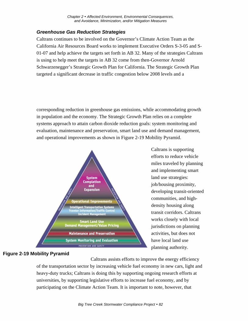
Chapter 2 Affected Environment, Environmental Consequences, and Avoidance, Minimization, and/or Mitigation Measures
Big Tree Creek Stormwater Compliance Project 82
Greenhouse Gas Reduction Strategies
Caltrans continues to be involved on the Governor’s Climate Action Team as the
California Air Resources Board works to implement Executive Orders S-3-05 and S-
01-07 and help achieve the targets set forth in AB 32. Many of the strategies Caltrans
is using to help meet the targets in AB 32 come from then-Governor Arnold
Schwarzenegger’s Strategic Growth Plan for California. The Strategic Growth Plan
targeted a significant decrease in traffic congestion below 2008 levels and a
corresponding reduction in greenhouse gas emissions, while accommodating growth
in population and the economy. The Strategic Growth Plan relies on a complete
systems approach to attain carbon dioxide reduction goals: system monitoring and
evaluation, maintenance and preservation, smart land use and demand management,
and operational improvements as shown in Figure 2-19 Mobility Pyramid.
Caltrans is supporting
efforts to reduce vehicle
miles traveled by planning
and implementing smart
land use strategies:
job/housing proximity,
developing transit-oriented
communities, and high-
density housing along
transit corridors. Caltrans
works closely with local
jurisdictions on planning
activities, but does not
have local land use
planning authority.
Caltrans assists efforts to improve the energy efficiency
of the transportation sector by increasing vehicle fuel economy in new cars, light and
heavy-duty trucks; Caltrans is doing this by supporting ongoing research efforts at
universities, by supporting legislative efforts to increase fuel economy, and by
participating on the Climate Action Team. It is important to note, however, that
Figure 2-19 Mobility Pyramid
Chapter 2 Affected Environment, Environmental Consequences, and Avoidance, Minimization, and/or Mitigation Measures
Big Tree Creek Stormwater Compliance Project 83
control of fuel economy standards is held by the U.S. EPA and California Air
Resources Board.
Caltrans is also working toward enhancing the state’s transportation planning process
to respond to future challenges. Similar to requirements for regional transportation
plans under Senate Bill (SB) 375 (Steinberg 2008), SB 391(Liu 2009) requires the
state’s long-range transportation plan to meet California’s climate change goals under
AB 32.
The California Transportation Plan is a statewide, long-range transportation plan to
meet our future mobility needs and reduce greenhouse gas emissions. The California
Transportation Plan defines performance-based goals, policies, and strategies to
achieve our collective vision for California’s future, statewide, integrated, multimodal
transportation system. The purpose of the plan is to provide a common policy
framework that will guide transportation investments and decisions by all levels of
government, the private sector, and other transportation stakeholders. Through this
policy framework, the California Transportation Plan 2040 will identify the statewide
transportation system needed to achieve maximum feasible greenhouse gas emission
reductions while meeting the state’s transportation needs.
Table 2.3 summarizes the local and statewide efforts that Caltrans is implementing to
reduce greenhouse gas emissions. More detailed information about each strategy is
included in the Climate Action Program at Caltrans (December 2006).
Climate Change (June 22, 2012) is intended to establish a Caltrans policy that will
ensure coordinated efforts to incorporate climate change into Caltrans decisions and
activities. Caltrans Activities to Address Climate Change (April 2013) provides a
comprehensive overview of activities undertaken by Caltrans statewide to reduce
greenhouse gas emissions resulting from agency operations.
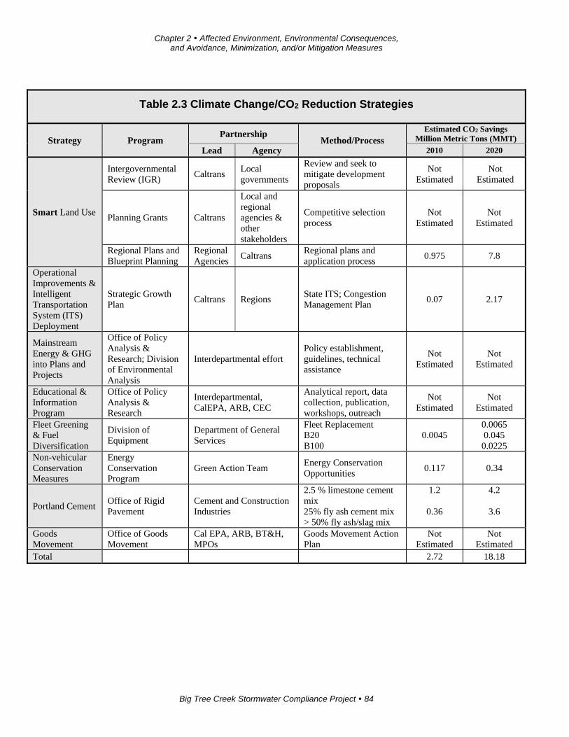
Chapter 2 Affected Environment, Environmental Consequences, and Avoidance, Minimization, and/or Mitigation Measures
Big Tree Creek Stormwater Compliance Project 84
Table 2.3 Climate Change/CO2 Reduction Strategies
Strategy Program Partnership
Method/Process Estimated CO2 Savings
Million Metric Tons (MMT)
Lead Agency 2010 2020
Smart Land Use
Intergovernmental Review (IGR)
Caltrans Local governments
Review and seek to mitigate development proposals
Not Estimated
Not Estimated
Planning Grants Caltrans
Local and regional agencies & other stakeholders
Competitive selection process
Not Estimated
Not Estimated
Regional Plans and Blueprint Planning
Regional Agencies
Caltrans Regional plans and application process
0.975 7.8
Operational Improvements & Intelligent Transportation System (ITS) Deployment
Strategic Growth Plan
Caltrans Regions State ITS; Congestion Management Plan
0.07 2.17
Mainstream Energy & GHG into Plans and Projects
Office of Policy Analysis & Research; Division of Environmental Analysis
Interdepartmental effort Policy establishment, guidelines, technical assistance
Not Estimated
Not Estimated
Educational & Information Program
Office of Policy Analysis & Research
Interdepartmental, CalEPA, ARB, CEC
Analytical report, data collection, publication, workshops, outreach
Not Estimated
Not Estimated
Fleet Greening & Fuel Diversification
Division of Equipment
Department of General Services
Fleet Replacement B20 B100
0.0045 0.0065 0.045 0.0225
Non-vehicular Conservation Measures
Energy Conservation Program
Green Action Team Energy Conservation Opportunities
0.117 0.34
Portland Cement Office of Rigid Pavement
Cement and Construction Industries
2.5 % limestone cement mix 25% fly ash cement mix > 50% fly ash/slag mix
1.2
0.36
4.2
3.6
Goods Movement
Office of Goods Movement
Cal EPA, ARB, BT&H, MPOs
Goods Movement Action Plan
Not Estimated
Not Estimated
Total 2.72 18.18
Chapter 2 Affected Environment, Environmental Consequences, and Avoidance, Minimization, and/or Mitigation Measures
Big Tree Creek Stormwater Compliance Project 85
The following measures would be included in the project to reduce the greenhouse
gas emissions and potential climate change impacts from the project:
1. Landscaping reduces surface warming and, through photosynthesis, decreases
carbon dioxide (CO2). The project proposes planting in the intersection slopes,
drainage channels, and seeding in areas next to frontage roads as well as
planting a variety of different-sized plant material and scattered skyline trees
where appropriate (but not to obstruct the view of the mountains). Caltrans
has committed to planting at least 40 trees. These trees will help offset any
potential carbon dioxide emissions increase.
2. The California Air Resources Board restricts idling of diesel off-road vehicles
to no more than five consecutive minutes, unless the vehicle is idling for
specific circumstances defined in the regulation or a waiver has been
granted.
Adaptation Strategies
Adaptation strategies are ways that Caltrans and others can plan for the effects of
climate change on the state’s transportation infrastructure and strengthen or protect
the facilities from damage. Climate change is expected to produce increased
variability in precipitation, rising temperatures, rising sea levels, variability in storm
surges and intensity, and the frequency and intensity of wildfires.
These changes may affect the transportation infrastructure in various ways, such as
damage to roadbeds from longer periods of intense heat; increasing storm damage
from flooding and erosion; and inundation from rising sea levels. These effects will
vary by location and may, in the most extreme cases, require that a facility be
relocated or redesigned. There may also be economic and strategic ramifications as a
result of these types of impacts to the transportation infrastructure.
Interim guidance has been released by the Coastal Ocean Climate Action Team (CO-
CAT) as well as Caltrans as a way to initiate action and discussion of potential risks
to the state’s infrastructure due to projected sea level rise.
Chapter 2 Affected Environment, Environmental Consequences, and Avoidance, Minimization, and/or Mitigation Measures
Big Tree Creek Stormwater Compliance Project 86
Executive Order S-13-08 also directed the Business, Transportation, and Housing
Agency (now the Transportation Agency) to prepare a report to assess vulnerability of
transportation systems to sea level rise affecting safety, maintenance and operational
improvements of the system, and economy of the state. Caltrans continues to work on
assessing the transportation system vulnerability to climate change, including the
effect of sea level rise.
The proposed project is outside the coastal zone, and direct impacts to transportation
facilities due to projected sea level rise are not expected.
Big Tree Creek Stormwater Compliance Project 87
Chapter 3 Comments and Coordination
Early and continuing coordination with the general public and appropriate public
agencies is an essential part of the environmental process. It helps planners determine
the necessary scope of environmental documentation and the level of analysis
required, and to identify potential impacts and mitigation measures and related
environmental requirements. Agency consultation and public participation for this
project have been accomplished through a variety of formal and informal methods,
including: Project Development Team meetings, interagency coordination meetings,
and public meetings.
This chapter summarizes the results of the Department’s efforts to identify, address
and resolve project-related issues through early and continuing coordination.
California Department of Parks and Recreation
September 9, 2010—Caltrans received a permit from the California Department of
Parks and Recreation to conduct archaeology studies.
August 1, 2014— The Office of Grants and Local Services with the California
Department of Parks and Recreation sent a letter (see Appendix G) indicating that
while the project is within land protected under the Land and Water Conservation
Fund (Section 6(f)), the use of that parcel was not incompatible with recreation uses
nor would it change or restrict access to the park, so the project will not constitute a
conversion of Section 6(f) property.
Calaveras Big Trees State Park
February 8, 2010—Caltrans spoke with Ms. Patricia Raggio (Environmental
Scientist) concerning biological resources and surveys within the Calaveras Big Trees
State Park. Ms. Raggio indicated that, while some California red-legged frog
sightings were recorded in the 1950s, identification was questionable. No California
red-legged frogs have been identified within Big Tree Creek since, and the species
was deemed completely gone from the park. Park personal have conducted surveys
for the Pacific fisher and it, too, is thought to be completely gone from the park.
September 9, 2010—Caltrans received from Calaveras Big Trees State Park the
signed Department of Parks and Recreation 412A Permit to Conduct Extended Phase
I (XPI) Archaeological Investigations within Calaveras Big Trees State Park.
Chapter 3 Comments and Coordination
Big Tree Creek Stormwater Compliance Project 88
October 12-13, 2010—Caltrans completed the Extended Phase I investigation at two
archaeological sites within the proposed project’s area of potential effects. Native
American monitors were present both days.
January 26, 2011—Caltrans mailed a letter to Jess Cooper, State Park District
Superintendent, at Central Valley District, describing the proposed construction
project, consultation efforts with State Park to date, and outlining the history of
archaeological investigations performed by Caltrans. This letter also brought to his
attention the likelihood of a Phase II eligibility evaluation of the archaeological sites
recorded and tested.
April 4, 2011—A meeting was held between Caltrans and the Calaveras Big Trees
State Park staff to discuss project issues and concerns, including impacts to the
campground, impacts to cultural resources, and the concern that the entire park is a
Section 6(f) property.
June 1, 2011—Caltrans met with representatives of Calaveras Big Trees State Park.
At that meeting, park staff requested documentation of the scientific quantitative data
showing the degradation of the aquatic habitat from sand and salt.
June 14, 2011—Caltrans sent a response to comments the park staff made at the June
1, 2011 meeting. In the letter, Caltrans explained how the National Pollutant
Discharge Elimination System permit was violated and noted that the Regional Water
Quality Control Board intends to enforce the permit.
On June 24, 2010—Caltrans and California State Park met at Calaveras Big Trees
State Park. This meeting was informal and provided the State Park with a proposed
project overview and provided Caltrans an understanding of State Park’s expectations
and requirements.
February 28, 2011—A letter from Liz Steller, State Park-District Services Manager,
Central Valley District, was received listing a series of elements and requests
regarding project environmental review process/procedures and documentation
needed going forward.
April 4, 2011—A Meeting was held to strengthen communication and create a
partnership between the Caltrans Project Delivery Team and State Park staff.
July 7, 2011—Caltrans received a letter from Liz Steller, stating that the park did not
feel that Caltrans had made the case for the need of the project and that the park will
Chapter 3 Comments and Coordination
Big Tree Creek Stormwater Compliance Project 89
no longer proceed on permits or reviews. The park felt that Caltrans should study the
impacts of the sand that’s getting into the creek.
March 21, 2012— A project team meeting was held with Calaveras Big Trees State
Park staff. Caltrans provided maps and a project description. Park staff expressed
concerns about project impacts to the campgrounds, particularly noise impacts. Park
staff members were also concerned about visual impacts to the Ebbetts Pass corridor
and to cultural and biological resources.
August 2, 2012—Caltrans sent layouts of the project from the public meeting and
identified times that would be best to conduct noise studies.
November 19, 2012—Caltrans received from State Park the signed Department of
Parks and Recreation 412A Permit to Conduct Phase II Eligibility Investigations
within Calaveras Big Trees State Park.
April 12, 2013— Caltrans received a table of information from Calaveras Big Trees
State Park about issues with the project. The table outlined some of the park’s main
concerns: loss of trees and habitat, impact to wildlife, loss of land/soil and rock
formation, cultural resources, impact to camping experience and park ambience, noise
impacts, loss of campsites, and visual impacts.
April 12, 2013—Caltrans received a copy of the letter sent to Liz Steller from the
State Parks Land and Conservation Fund Manager concerning Section 6(f). The letter
indicated that the entire park—not just the area originally purchased—was under
Section 6(f) protection.
April 24, 2013—Caltrans sent an email asking Calaveras Big Trees State Park when
noise is an issue at North Grove campground.
April 27, 2013— Caltrans received an email from Calaveras Big Trees State Park
about traffic and noise at North Grove campground. The email indicated times when
park staff felt traffic and noise impacts were most prevalent.
June 12, 2013—Caltrans invited the State Park staff and archaeologist to visit and/or
participate in the Phase II investigation scheduled for June 18-28, 2013.
June 18-28, 2013—The consultant completed Phase II eligibility evaluation testing at
archaeological site(s) within the proposed project’s area of potential effects.
Chapter 3 Comments and Coordination
Big Tree Creek Stormwater Compliance Project 90
July 11, 2013—Caltrans received a letter outlining the impacts to address in the
environmental document. The concerns included: impacts to park revenue, park
facilities, and campgrounds; concerns over the impact to the septic field; visual
impacts; the need to change the general plan; cultural and biology impacts.
July 24, 2013—Caltrans sent an email to Liz Steller (Park Supervisor) about the
location of a septic leach field, noting that the project would not affect it.
December 18, 2013—The Historic Property Survey Report was mailed to Linda-Dick
Bissonnette, Cultural Resources Specialist, at State Park. Additional copies were
mailed to Liz Steller, State Park-District Services Manager.
February 21, 2014: Caltrans mailed the Draft Finding of Adverse Effects (Draft FOE)
package to State Park for distribution to designated staff for review and comment.
April 1, 2014—Caltrans received an email notice from Liz Steller, District Services
Manager, Central Valley District, State Park, stating that California State Park has no
questions and/or concerns with the Draft Finding of Adverse Effects package.
April 28, 2014—Caltrans and Calaveras Big Trees State Park met to discuss the
project. Caltrans indicated an interest in the park agreeing to a de minimis
determination. Park staff indicated an interest in the following issues: relocating the
campsites along State Route 4 and improving pedestrian access across State Route 4.
Caltrans indicated it would look at traffic-calming solutions that would not affect the
project limits. Also discussed were locations for the Section 6(f) replacement
property. Park staff indicated they would send a letter indicating their estimates for
the campground relocation.
May 15, 2014—Calevaras Big Trees State Park sent a letter to Caltrans outlining
mitigation it was requesting: habitat and tree replacement, invasive species control,
relocation of 20 campgrounds, curate of cultural resources, left-turn pocket for road to
campground, and a pedestrian undercrossing from the campground to staff parking.
June 23, 2014—Calaveras Big Trees State Park staff met with the Caltrans District
Director to voice their concerns about dropping Alternative 1.
July 10, 2014—Calaveras Big Trees State Park sent a letter indicating that Alternative
2 would be unacceptable due to visual and noise impacts. The letter also indicated
that a Section 4(f) de minimis would acceptable if Caltrans and Calaveras State Park
Chapter 3 Comments and Coordination
Big Tree Creek Stormwater Compliance Project 91
can agree on appropriate mitigation. The mitigation included, relocation of 11
campsites.
It also indicated that park staff is in contact with National Park Service with regard to
the Land and Water Conservation Fund and its restrictions; park staff is trying to find
a way to exempt the project from the restrictions.
August 12, 2014—Calaveras Big Trees State Park sent a letter outlining the following
concerns about campground relocations: the campground relocations will require a
higher document than a Negative Declaration; additional construction would be
required to have the campground comply with the American with Disabilities Act;
utilities will need to be upgraded; and the new sites will have a trail created to
connect it to existing pedestrian trails. The park reduced the number of relocations to
five campsites.
October 10, 2014— Caltrans sent a letter requesting concurrence on our Section 4(f)
de minimis determination, from Calaveras Big Trees State Park.
October 29, 2014—Calaveras Big Trees State Park concurred with Caltrans on its de
minimis determination.
U.S. Fish and Wildlife Service
May 4, 2012—A sensitive species list was obtained from the U.S. Fish and Wildlife
Service Sacramento office. Later studies indicated that there were no federally listed
threatened or endangered species affected by the project, and there was only one
species of concern—the yellow-legged frog.
August 8, 2014—An updated sensitive species list was obtained from the U.S. Fish
and Wildlife Service Sacramento office. No additional special-status species have
been added since 2012.
U.S. Forest Service
February 11, 2010—Ms. Melinda Benton sent Caltrans a list of federally threatened,
endangered, and sensitive species from the Regional Foresters Sensitive Species List
that are likely to be in or near the project area. She also noted that the California
wolverine and Pacific fisher are highly unlikely to be present in the project area due
to the project’s close proximity to human disturbance and lack of credible sightings in
the area.
Chapter 3 Comments and Coordination
Big Tree Creek Stormwater Compliance Project 92
February 9, 2011—Caltrans spoke with Ms. Melinda Benton. Caltrans described the
project to Ms. Benton and discussed the potential for the Pacific fisher to be present
within the project area. Ms. Benton told Caltrans that fishers require a closed canopy
in old growth forests and they are sensitive to noise. Traffic on State Route 4 will be a
deterrent for the fisher. She stated that monitoring stations have been set up in the
Stanislaus National Forest and no fishers have been observed. She mentioned that
there have been potential sightings near the Bear Valley Ski Area, but they have not
been substantiated. She stated that the nearest fisher sighting was made in the El
Dorado National Forest. She also mentioned a sighting of a nesting California spotted
owl near Sourgrass in Calaveras County. Ms. Benton is going to look through the
Regional Foresters Sensitive Species List and provide information on sensitive
species that could occur within the project area. It was later determined that there was
no habitat for fisher within the project area.
February 9, 2011—Caltrans sent Ms. Benton a project description and mapping.
February 10, 2011—Caltrans spoke with Mr. Derrick Bowden. He told Caltrans that
the project is located in a transitional zone (elevation) between the foothill yellow-
legged frog and Sierra Nevada yellow-legged frog (Rana sierrae) (formerly known as
the mountain yellow-legged frog). The project is also located within the upper range
of the California red-legged frog (Rana aurora draytonii). He recommended Caltrans
look at the recovery plan for the red-legged frog.
He recommended examining the downstream effects of the proposed project on the
aquatic species. Caltrans told Mr. Bowden that silt fencing and environmentally
sensitive area fencing will be used to avoid and minimize potential temporary impacts
to the aquatic habitat of Big Tree Creek. He agreed with these measures. He did
express concerns with sedimentation during the reproduction period of the frogs. He
recommended that Caltrans look for egg masses in the creek prior to implementation
of the project. Caltrans told Mr. Bowden that pre-construction surveys and
monitoring would be done.
California Department of Fish and Wildlife
February 8, 2011— Caltrans told Mr. Nossal of the California Department of Fish
and Wildlife that the project will affect riparian and conifer habitat next to Big Tree
Creek. Caltrans inquired about mitigation for impacts to these habitats. Mr. Nossal
stated that removal of conifers may be beneficial and enhance the riparian habitat. He
said that riparian habitat is usually mitigated at a 3:1 ratio. Caltrans stated that
Chapter 3 Comments and Coordination
Big Tree Creek Stormwater Compliance Project 93
replanting onsite will be difficult due to space constraints and inquired if Mr. Nossal
had any recommendations. Mr. Nossal stated that a potential mitigation strategy
would be to enhance riparian habitat (in kind) within the park.
February 9, 2011—Caltrans sent Mr. Nossal a project description and mapping.
Caltrans also requested mitigation ratios for the removal of black oaks (Quercus
kelloggii). The black oaks were later determined to be mitigated as part of the riparian
habitat.
February 9, 2011—Caltrans received an email from Mr. Nossal, who stated that
mitigation for conifers depends on the individual trees onsite. A tree with a nest
cavity that can harbor owls or mesocarnivores will be treated differently than a stand
of crowded, stunted trees. He requested that Caltrans take a look at mitigation on past
projects. This was done in evaluating the impacts in the Natural Environment Study.
Mr. Nossal listed various mitigation options implemented in the past for oaks,
including inch-for-inch diameter replacement for trees greater than 12 inches in
diameter at breast height (dbh); 3:1 replacement for oaks 4-12 inches in diameter at
breast height; 10:1 replacement, and 2 acres of habitat created or enhanced for every
1 acre removed. He stated that it depends on the details of the site being affected. It
would later be determined that the project will not impact oaks.
State Historic Preservation Officer (Cultural Resources)
There has been substantial coordination with the State Historic Preservation Officer
per Section 106 of the National Historic Preservation Act. The correspondence is
summarized as follows (refer to Appendix F for related correspondence):
Caltrans submitted the Historic Property Survey Report to the State Historic
Preservation Officer on December 12, 2013. The document determined the Area of
Potential Effects (APE), identified cultural resources located within the Area of
Potential Effects, and provided an evaluation of properties for eligibility to the
National Register of Historic Places. Caltrans identified one archaeological site
within the Area of Potential Effects eligible for listing in the National Register of
Historic Places and one historic-period property within the architectural Area of
Potential Effects that has either been listed on or determined eligible for listing in the
National Register of Historic Places.
Chapter 3 Comments and Coordination
Big Tree Creek Stormwater Compliance Project 94
On January 23, 2014, the State Historic Preservation Officer concurred on the
adequacy of the identification effort and the revised and current eligibility
determinations.
On Jaunary 12, 2015, Caltrans finalized the Memorandum of Agreement to address
how to minimize and prevent impacts to cultural resources.
California Native American Heritage Commission
March 3, 2009—Caltrans sent a request for a renewed Sacred Lands Request and
Native American Referral for the project to update the 2001 requested results and
contact list.
May 13, 2009—The California Native American Heritage Commission failed to
indicate the presence of Sacred Lands and provided the following contacts (note: the
spelling of Miwok, Miwuk and Mi-Wuk in the following list and the rest of this
document represents the chosen spelling for that specific group or entity):
Honorable Chairperson Matthew Franklin, Ione Band of Miwok Indians
Honorable Chairperson Burley, California Valley Miwok Tribe
Chairwoman Gloria Jeff Grimes, Calaveras Band of Miwuk Indians
Ms. Arvada Fisher, Vice Chair, Calaveras Co. Mountain Miwok Indian
Council
Ms. Debra Grimes, Specialist for Calaveras Band of Miwuk Indians
Ms. Lois Williams, Calaveras Band of Mi-Wuk Indians
Ms. Billie Blue, Ione Cultural Heritage Committee Chairman
Native American Coordination
Consultation with Native American groups and individuals has been conducted
through letters, phone conversations, email correspondence, mailings, meetings and
field visits since 2009. Consultation began with a letter sent to the Native American
Heritage Commission (NAHC) on March 3, 2009, requesting a Sacred Lands Search,
based on the Cultural Studies Request of 2009 for a proposed stormwater mitigation
project and area limits.
On March 19, 2009, Caltrans received the Sacred Lands Search results, which did not
identify historic properties within the project limits. The Native American Heritage

Chapter 3 Comments and Coordination
Big Tree Creek Stormwater Compliance Project 95
Commission provided Caltrans with a list of Native American contacts to consult for
more information. The contact list included the following:
Chairperson Gloria Grimes, Calaveras Band of Miwuk Indians
Debra Grimes, Cultural Resources Specialist, Calaveras Band of Miwuk
Indians
Ms. Arvada Fisher, Vice Chair, Calaveras Co. Mountain Miwok Indian
Council
Honorable Chairperson Matthew Franklin, Ione Band of Miwok Indians
Ione Band of Miwok Indians, Heritage Cultural Committee
Silvia Burley, California Valley Miwok Tribe
In August 2009, the Caltrans District Native American Coordinator (DNAC) sent
letters with maps requesting information from the individuals on the Native American
Heritage Commission contact list as well as those on the District 10 Native American
consultation list, as follows:
Chairperson Gloria Grimes, Calaveras Band of Miwuk Indians
Debra Grimes, Cultural Resources Specialist, Calaveras Band of Miwuk
Indians
Ms. Arvada Fisher, Vice Chair, Calaveras Co. Mountain Miwok Indian
Council
Honorable Chairperson Matthew Franklin, Ione Band of Miwok Indians
Ione Band of Miwok Indians, Heritage Cultural Committee
Silvia Burley, California Valley Miwok Tribe
Ms. Lois Williams, Calaveras Band of Mi-Wuk Indians
Mr. Nicolas Villa Jr., Chief, Ione Band of Miwok of the Yung-Buu-tee
Village
Ms. Billie Blue, Ione Cultural Heritage Committee (Former) Chair
Of the above individuals consulted, only two individuals responded—Ms. Billie Blue
wished to defer their tribe’s comments to the tribes in Calaveras County, specifically
to Debra Grimes. Ms. Grimes responded by email on November 19, 2009, requesting
Chapter 3 Comments and Coordination
Big Tree Creek Stormwater Compliance Project 96
a field visit. Caltrans informed Ms. Grimes that Caltrans would coordinate another
field visit prior to the anticipated Phase II eligibility evaluation testing.
In 2010, the Caltrans District Native American Coordinator requested an updated list
of Native American contacts from the Native American Heritage Commission. That
list included the following additional individuals:
Rhonda Morningstar Pope, Chairperson, Buena Vista Rancheria
Charles Wilson, Chairperson, Calaveras Band of Mi-Wuk Indians
Briana Creekmore, Cultural Committee, Miwok
Ms. Dolores Turner, Chairperson, Calaveras Co. Mountain MiWuk Indian
Council
On May 13, 2010—Caltrans held a meeting with Briana Creekmore and another
member of the Miwok community in West Point, California. The meeting discussed
all proposed Caltrans projects in Calaveras County going forward. Ms. Creekmore
and Pete Ramirez stated that they had a strong interest in the Big Tree Creek
Stormwater Compliance project.
September 30, 2010—The Caltrans District Native American Coordinator sent
follow-up letters describing the proposed stormwater compliance project and
notification of the proposed Extended Phase I (XPI) investigation to the individuals
listed above in the 2009/2010 contact list.
November 22, 2010—The Caltrans District Native American Coordinator sent letters
to the contacts of the 2009/2010 list requesting any information and/or concerns
regarding the project. No responses were received by Caltrans.
December 7, 2010—Caltrans met with Ms. Grimes and a tribal representative to
discuss the project and proposed Extended Phase I activities. Ms. Grimes stated that
she had information about the project area, but did not want to share with Caltrans.
December 10, 2010—The Caltrans District Native American Coordinator mailed the
Draft Archeological Survey Report/Extended Phase I Report to the individuals listed
above on the 2009/2010 contact list. The Caltrans District Native American
Coordinator requested their participation in the review of the reports and if they had
any questions, concerns, or information to add. No responses were received by
Caltrans for the 30-day review period.
Chapter 3 Comments and Coordination
Big Tree Creek Stormwater Compliance Project 97
January 4, 2011—The Caltrans District Native American Coordinator placed follow-
up calls to the individuals who were sent the Draft Archeological Survey Report
/Extended Phase I Report and asked if there were any questions and/or concerns. Mr.
Villa Jr. responded by deferring his comments to Debra Grimes. No other responses
were received by Caltrans.
May 20, 2011—Caltrans sent letters to the individuals listed on the 2009/2010 contact
list to notify those individuals of the proposed Phase II eligibility evaluation
investigation.
June 8, 2011—Caltrans sent the Archaeological Evaluation Proposal (AEP) to the
following:
Ms. Dolores Turner, Chairperson, Calaveras Co. Mountain MiWuk Indian
Council
Ms. Gloria Jeff Grimes, Chairperson, Calaveras Band of Me-Wuk
Mr. Johnny “Gil” Jamerson, (Former) Chairperson Ione Band of Miwok
Indians
Ms. Billie Blue, Ione Cultural Heritage Committee (Former) Chair
Mr. Charles Wilson, Chairperson, Calaveras Band of Mi-Wuk Indians
Ms. Silvia Burley, Chairperson, California Valley Miwok Tribe
Mr. Nicolas Villa Jr., Chief, Ione Band of Miwok of the Yung-Buu-tee
Village
Ms. Dolores Turner, Chairperson, Calaveras Co. Mountain MiWuk Indian
Council
Ms. Lois Williams, Calaveras Band of Mi-Wuk Indians
Ms. Debra Grimes, Director, Cultural Preservation Specialist, California
Valley Miwok Tribe
No responses were received by Caltrans regarding the review of the Archaeological
Evaluation Proposal provided to the above individuals.
October 12, 2012—The Caltrans District 10 Native American Coordinator provided a
project update letter that included a description of all of the alternative construction
Chapter 3 Comments and Coordination
Big Tree Creek Stormwater Compliance Project 98
design summaries being considered, as well as an additional copy of the
Archaeological Evaluation Proposal to:
Ms. Dolores Turner, Chairperson, Calaveras Co. Mountain MiWuk Indian
Council
Ms. Gloria Jeff Grimes, Tribal Chairperson, Calaveras Band of Me-Wuk
Mr. Johnny “Gil” Jamerson, (Former) Chairperson Ione Band of Miwok
Indians
Ms. Billie Blue, Ione Cultural Heritage Committee (Former) Chair
Mr. Anthony Burris, Cultural Heritage Committee Chair, Ione Band of Miwok
Indians
Ms. Silvia Burley, Chairperson, California Valley Miwok Tribe
Ms. Briana Creekmore, Miwok
Ms. Dolores Turner, Chairperson, Calaveras Co. Mountain MiWuk Indian
Council
Ms. Lois Williams, Calaveras Band of Mi-Wuk Indians
Ms. Debra Grimes, Director, Cultural Preservation Specialist, California
Valley Miwok Tribe
Mr. Darrel Cruz, Cultural Resource Office /Tribal Historic Preservation
Officer Director, Washoe
Ms. Roselynn Lwenya, Tribal Historic Preservation Officer /Environmental
Resources Director Buena Vista Rancheria
Ms. Rhonda Morningstar-Pope, Chairperson Buena Vista Rancheria
Mr. Charles Wilson, Chairperson, Calaveras Band of Mi-Wuk Indians
Honorable Chairwoman Yvonne Miller, Cultural Heritage Committee, Ione
Band of Miwok Indians
October 30, 2012—Caltrans held an onsite field visit with local Miwoks Briana
Creekmore and Lawrence Wilson, Jr.; Caltrans project personnel Mary Oliva,
Raymond Benson, and Tina Fulton attended. The field visit was requested by Briana
Creekmore to answer concerns regarding the Archaeological Evaluation Proposal that
were mentioned in the recent Cultural Resources Investigation Report mailed to the
Chapter 3 Comments and Coordination
Big Tree Creek Stormwater Compliance Project 99
Native American contacts. Lawrence Wilson Jr. felt the area was a village site and
requested a copy of the Extended Phase I Report. Tina Fulton, the Caltrans District
Native American Coordinator, mailed Mr. Wilson a copy of the Cultural Resources
Investigation Report, which included the Extended Phase I Report.
No responses were received by Caltrans regarding the Archaeological Evaluation
Proposal that was mailed on October 12, 2012.
Caltrans developed a Cultural Resources Investigation (CRI) Report explicitly for
consultation. The intent of the Cultural Resources Investigation was to provide the
reviewer a better understanding of Caltrans’ efforts in providing a history of the
archaeological record, current identification efforts, with survey and testing projects,
and results that have occurred within the project area limits between 2009 and 2012.
January 10, 2013—Caltrans sent the Cultural Resources Investigation Report to:
Ms. Dolores Turner, Chairperson, Calaveras Co. Mountain MiWuk Indian
Council
Ms. Gloria Jeff Grimes, Chairperson, Calaveras Band of Me-Wuk
Mr. Johnny “Gil” Jamerson, (Former) Chairperson Ione Band of Miwok
Indians
Ms. Billie Blue, Ione Cultural Heritage Committee (Former) Chair
Mr. Charles Wilson, Chairperson, Calaveras Band of Mi-Wuk Indians
Ms. Silvia Burley, Chairperson, California Valley Miwok Tribe
Mr. Nicolas Villa Jr., Chief, Ione Band of Miwok of the Yung-Buu-tee
Village
Ms. Dolores Turner, Chairperson, Calaveras Co. Mountain MiWuk Indian
Council
Ms. Lois Williams, Calaveras Band of Mi-Wuk Indians
Ms. Debra Grimes, Director, Cultural Preservation Specialist, California
Valley Miwok Tribe
December 18, 2013—The Caltrans District Native American Coordinator mailed
copies of the Historic Property Survey Report (HPSR) to all of the individuals listed
Chapter 3 Comments and Coordination
Big Tree Creek Stormwater Compliance Project 100
above. There were no responses received by Caltrans regarding issues or concerns of
the Historic Property Survey Report.
March 13, 2014— The Caltrans District Native American Coordinator received an
email, phone call, and letter from Darrel Cruz, and members of the Washoe Tribe
with concerns about the bedrock milling stations. They want to see the bedrock
milling stations preserved in place or moved to another location in the park.
March 26, 2014— The Caltrans District Native American Coordinator emailed a
response to Mr. Cruz’s concerns.
March 28, 2014—Tina Fulton, the Caltrans District 10 Native American Coordinator,
mailed copies of the Draft Finding of Effects package to all of the individuals on the
above Native American contact list, with the addition of Darrel Cruz.
April 23, 2014— The Caltrans District Native American Coordinator received a
phone call from Darrel Cruz, Washoe Tribe, requesting information about the project.
The Caltrans District Native American Coordinator and Archaeologist scheduled a
meeting onsite, in the field, on May 7, 2014 to review and discuss the proposed
project and Native American concerns. The field visit was cancelled due to weather
conditions.
May 7, 2014— The Caltrans District Native American Coordinator mailed the Draft
Archaeological Evaluation Report to the following:
Chairperson Gloria Grimes, Calaveras Band of Miwuk Indians
Debra Grimes, Cultural Resources Specialist, Calaveras Band of Miwuk
Indians
Briana Creekmore, Miwok
Mr. Darrel Cruz, Tribal Historic Preservation Officer, Washoe Tribe of
Nevada and California
Mr. Darrel Kizer, Chairperson Washoe Tribe of Nevada and California
Ms. Rhonda Morningstar-Pope, Chairperson Buena Vista Rancheria
Ms. Roselynn Lwenya, Tribal Historic Preservation Officer/Environmental
Resources Director Buena Vista Rancheria
Chapter 3 Comments and Coordination
Big Tree Creek Stormwater Compliance Project 101
Mr. Pete Ramirez, Miwok representing Buena Vista Rancheria and Sheep
Ranch Rancheria
Mr. Randy Yonemura, Ione Band of Miwok Indians
Ms. Lynda Shoshone, Washoe Tribe of Nevada and California
The cover letter requested comments or concerns to be directed to Raymond Benson,
the project archaeologist. Mr. Benson did not receive any communication with
comments and/or concerns up to submittal of the final Draft Archaeological
Evaluation Proposal to consultant on June 15, 2014.
August 12, 2013 through September 2, 2013, various times—Lynda Shoshone, a
member of the Washoe Tribe consulted with the Caltrans District Native American
Coordinator. Ms Shoshone requested project information and voiced concern and
comments. Caltrans sent two copies of the Cultural Resources Investigation Report,
as requested, with a cover letter and copy of emails of her request for reference.
March 13, 2014—Darrel Cruz, Tribal Historic Preservation Officer for the Washoe
Tribe of Nevada and California, called, emailed, and sent a letter to the Caltrans
District Native American Coordinator regarding the proposed outcome of the extant
bedrock milling stations within the project area limits. On March 28, 2014, copies of
the Draft Finding of Effects package were mailed to Mr. Cruz.
May 7, 2014—Mr. Cruz contacted the Caltrans District Native American Coordinator
to discuss the following: 1) how the contractor will remove the bedrock mortar, and
where the bedrock mortar and soil will be relocated and 2) whether the bedrock
mortar will be moved from the current location in one piece, or in pieces?
May 7, 2014—A copy of the Draft Archaeological Evaluation Report was mailed to
Mr. Cruz.
May 30, 2014—Caltrans received a letter from Mr. Cruz stating: “after review of the
[Draft Finding of Effects] report, we see that the report has taken into account our
comments and concerns.”
Inter-Tribal Meetings, Consultation, and Field Work
Extended Phase I
October 12-13, 2010—Extended Phase I work was conducted. Caltrans
representatives Mary Oliva (Environmental Senior), Raymond Benson (Cultural
Specialist) and Tina Fulton, the Caltrans District Native American Coordinator,
Chapter 3 Comments and Coordination
Big Tree Creek Stormwater Compliance Project 102
Debra Grimes, and Adam Lewis were present for the first day; Brian Creekmore and
Lawrence Wilson Jr. were present for the second day. Several shovel test units (STU)
were dug around the bedrock mortars resulting in the uncovering and collection of
numerous stone tools, flake stone, and other cultural artifacts.
September 18, 2013—Caltrans met with Lynda Shoshone of the Washoe Tribe of
Nevada and California and her invited guests, which included the new Chairperson of
the Washoe Tribe of Nevada, Darrel Kizer. Also, in attendance, were Chairwoman
Gloria J. Grimes and Debra Grimes of the Calaveras Band of Mi-Wuk Indians.
During the meeting, all of the tribal members agreed about protecting CA-CAL-
277/H and specifically the bedrock mortar. They did not want to see a wall put up
where the bedrock mortar was.
Phase II
May 21, 2013—Caltrans met with Far Western (contract consultant) and members of
the invited Native American Community. This was a pre-field meeting concerning the
proposed Phase II investigation at archaeological sites CA-CAL-2109 and -2104.
Attendees were Eric Wolhgemuth from Far Western, Tina Fulton and Raymond
Benson from Caltrans, Debra Grimes (Calaveras Band of Miwok) and Pete Ramirez
(Buena Vista Rancheria and Miwok).
June 18-27, 2013—A Phase II investigation conducted by Far Western had four
archaeologists of Native American origin who excavated, sifted and sorted
archaeological materials recovered from the site areas. Debra Grimes, Adam Lewis of
the Calaveras Band of Me-Wuk, and Pete Ramirez, Miwok, representing Buena Vista
Rancheria and Sheep Ranch Rancheria, were present as Native American monitors.
Public Information Meeting
Caltrans held a public information meeting for the State Route 4 Big Tree Creek
Stormwater Compliance project on August 15, 2012, from 4:00 p.m. to 7:00 p.m. at
the Independence Hall Community Center at 1445 Blagen Road in Arnold in
Calaveras County. An ad was placed in The Calaveras Enterprise on August 3, 2012
to inform the public of the meeting.
The meeting had an informal format. The public was invited to join the meeting at
any time during the three-hour period between 4:00 p.m. and 7:00 p.m. Caltrans
personnel sat at the entrance to greet members of the public and encourage them to
sign in. Attendees were encouraged to visit the information stations around the room
Chapter 3 Comments and Coordination
Big Tree Creek Stormwater Compliance Project 103
and view graphics and display boards. The meeting featured four alternatives; two
were later dropped by the project.
Roughly seven people attended; three were from the Calaveras Big Trees State Park.
Caltrans staff wrote down all comments and questions heard at the meeting. The main
comment heard was this: The project is too expensive and a waste of state money.
No written comments were submitted at the meeting. Two letters and one email were
received following the meeting. The letters were submitted by the California Valley
Miwok Tribe and Calaveras Big Trees State Park. The email was from a resident of
Arnold opposing the project due to cost.
Draft Document Circulation and Opportunity for a Public Hearing
The draft environmental document was circulated for a 30-day review by agencies
and members of the public. Circulation began August 15, 2014 and ended September
15, 2014. A notice of intent to adopt a Notice of Determination and Section 4(f)
determination with opportunity to request a public meeting was placed in The
Calaveras Enterprise on August 15, 2014. No requests were received for a public
meeting.
During the circulation Caltrans received three responses all from State Agencies.
State Clearing House sent a letter indicating that we had completed our document
circulation process. The Central Valley Regional Water Quality Control Board sent a
letter outlining the permits that they administer to construction projects. California
Department of Fish and Wildlife sent an email with several comments concerning
biology issues.

Big Tree Creek Stormwater Compliance Project 105
Chapter 4 List of Preparers
This document was prepared by the following Caltrans Central Region staff:
Allam Alhabaly, Transportation Engineer. B.S., California State University, Fresno,
School of Engineering; 12 years of experience in environmental technical
studies, with emphasis on noise studies. Contribution: Noise Study.
Raymond Benson, Associate Environmental Planner (Archaeology). M.A., Cultural
Resources Management, Sonoma State University; B.A., Anthropology,
Minor in Geography, Humboldt State University; more than 25 years of
archaeology and 15 years of cultural resources management experience.
Contribution: Principal Investigator, Prehistoric and Historic Archaeology.
Rajeev Dwivedi, Associate Engineering Geologist. Ph.D., Environmental
Engineering, Oklahoma State University, Stillwater; 20 years of
environmental technical studies experience. Contribution: Air and Water
Quality Study.
David Farris, Associate Environmental Planner. B.S., Environmental Biology and
Management, University of California at Davis; 2 years of preliminary
environmental analysis experience; 11 years of environmental planning
experience. Contribution: Wrote the Initial Study/Environmental Assessment.
Rachel Kleinfelter, Associate Environmental Planner. B.A., Environmental Studies,
Mills College; 17 years of biology experience. Contribution: Biology surveys.
Shawn Ogletree, Associate Environmental Planner. B.S., Environmental
Conservation of Natural Resources, Texas Tech University; B.S.,
Wildlife/Fisheries Management, Texas Tech University; MPH, California
State University, Fresno; 10 years of environmental health, environmental
technical studies experience; 10 years of biology experience. Contribution:
Hazardous Waste Specialist.
Scott Smith, Senior Environmental Planner. B.A., Economics, California State
University, Fresno; 13 years of environmental planning experience.
Contribution: Senior reviewer of the Initial Study/Environmental Assessment.

Chapter 4 List of Preparers
Big Tree Creek Stormwater Compliance Project 106
Richard C. Stewart, Engineering Geologist, P.G. B.S., Geology, California State
University, Fresno; more than 20 years of hazardous waste and water quality
experience; 6 years of paleontology/geology experience. Contribution:
Paleontology Study.
Kriti Uppal, Environmental Planner (Biology). M.A., English (H.P University, India);
B.S., Environmental Science (Delhi University, India); Associate degree in
Natural Sciences (Sacramento City College); 4 years of experience in Natural
Sciences. Contribution: Natural Environment Study.
Big Tree Creek Stormwater Compliance Project 107
Appendix A California Environmental Quality Act Checklist
Supporting documentation of all California Environmental Quality Act checklist
determinations is provided in Chapter 2 of this Initial Study/Environmental
Assessment. Documentation of “No Impact” determinations is provided at the
beginning of Chapter 2. Discussion of all impacts, avoidance, minimization, and/or
mitigation measures under the appropriate topic headings in Chapter 2.

Potentially Significant Impact
Less Than Significant with Mitigation
Less Than Significant Impact
No Impact
Big Tree Creek Stormwater Compliance Project 108
I. AESTHETICS: Will the project:
a) Have a substantial adverse effect on a scenic vista
b) Substantially damage scenic resources, including, but not limited to, trees, rock outcroppings, and historic buildings within a state scenic highway
c) Substantially degrade the existing visual character or quality of the site and its surroundings?
d) Create a new source of substantial light or glare which will adversely affect day or nighttime views in the area?
II. AGRICULTURE AND FOREST RESOURCES: In determining whether impacts to agricultural resources are significant environmental effects, lead agencies may refer to the California Agricultural Land Evaluation and Site Assessment Model (1997) prepared by the California Dept. of Conservation as an optional model to use in assessing impacts on agriculture and farmland. In determining whether impacts to forest resources, including timberland, are significant environmental effects, lead agencies may refer to information compiled by the California Department of Forestry and Fire Protection regarding the state’s inventory of forest land, including the Forest and Range Assessment Project and the Forest Legacy Assessment Project; and the forest carbon measurement methodology provided in Forest Protocols adopted by the California Air Resources Board. Will the project:
a) Convert Prime Farmland, Unique Farmland, or Farmland of Statewide Importance (Farmland), as shown on the maps prepared pursuant to the Farmland Mapping and Monitoring Program of the California Resources Agency, to non-agricultural use?
b) Conflict with existing zoning for agricultural use, or a Williamson Act contract?
c) Conflict with existing zoning for, or cause rezoning of, forest land (as defined in Public Resources Code section 12220(g)), timberland (as defined by Public Resources Code section 4526), or timberland zoned Timberland Production (as defined by Government Code section 51104(g))?
d) Result in the loss of forest land or conversion of forest land to non-forest use?
e) Involve other changes in the existing environment which, due to their location or nature, could result in conversion of Farmland, to non-agricultural use or conversion of forest land to non-forest use?
III. AIR QUALITY: Where available, the significance criteria established by the applicable air quality management or air pollution control district may be relied upon to make the following determinations. Will the project:
a) Conflict with or obstruct implementation of the applicable air quality plan?

Potentially Significant Impact
Less Than Significant with Mitigation
Less Than Significant Impact
No Impact
Big Tree Creek Stormwater Compliance Project 109
b) Violate any air quality standard or contribute substantially to an existing or projected air quality violation?
c) Result in a cumulatively considerable net increase of any criteria pollutant for which the project region is non- attainment under an applicable federal or state ambient air quality standard (including releasing emissions which exceed quantitative thresholds for ozone precursors)?
d) Expose sensitive receptors to substantial pollutant concentrations?
e) Create objectionable odors affecting a substantial number of people?
IV. BIOLOGICAL RESOURCES: Will the project:
a) Have a substantial adverse effect, either directly or through habitat modifications, on any species identified as a candidate, sensitive, or special status species in local or regional plans, policies, or regulations, or by the California Department of Fish and Wildlife or U.S. Fish and Wildlife Service?
b) Have a substantial adverse effect on any riparian habitat or other sensitive natural community identified in local or regional plans, policies, regulations or by the California Department of Fish and Wildlife or U.S. Fish and Wildlife Service?
c) Have a substantial adverse effect on federally protected wetlands as defined by Section 404 of the Clean Water Act (including, but not limited to, marsh, vernal pool, coastal, etc.) through direct removal, filling, hydrological interruption, or other means?
d) Interfere substantially with the movement of any native resident or migratory fish or wildlife species or with established native resident or migratory wildlife corridors, or impede the use of native wildlife nursery sites?
e) Conflict with any local policies or ordinances protecting biological resources, such as a tree preservation policy or ordinance?
f) Conflict with the provisions of an adopted Habitat Conservation Plan, Natural Community Conservation Plan, or other approved local, regional, or state habitat conservation plan?
V. CULTURAL RESOURCES: Will the project:
a) Cause a substantial adverse change in the significance of a historical resource as defined in §15064.5?
b) Cause a substantial adverse change in the significance of an archaeological resource pursuant to §15064.5?
c) Directly or indirectly destroy a unique paleontological resource or site or unique geologic feature?

Potentially Significant Impact
Less Than Significant with Mitigation
Less Than Significant Impact
No Impact
Big Tree Creek Stormwater Compliance Project 110
d) Disturb any human remains, including those interred outside of formal cemeteries?
VI. GEOLOGY AND SOILS: Will the project:
a) Expose people or structures to potential substantial adverse effects, including the risk of loss, injury, or death involving:
i) Rupture of a known earthquake fault, as delineated on the most recent Alquist-Priolo Earthquake Fault Zoning Map issued by the State Geologist for the area or based on other substantial evidence of a known fault? Refer to Division of Mines and Geology Special Publication 42?
ii) Strong seismic ground shaking?
iii) Seismic-related ground failure, including liquefaction?
iv) Landslides?
b) Result in substantial soil erosion or the loss of topsoil?
c) Be located on a geologic unit or soil that is unstable, or that will become unstable as a result of the project, and potentially result in on- or off-site landslide, lateral spreading, subsidence, liquefaction or collapse?
d) Be located on expansive soil, as defined in Table 18-1-B of the Uniform Building Code (1994), creating substantial risks to life or property?
e) Have soils incapable of adequately supporting the use of septic tanks or alternative waste water disposal systems where sewers are not available for the disposal of waste water?
VII. GREENHOUSE GAS EMISSIONS: Will the project:
a) Generate greenhouse gas emissions, either directly or indirectly, that may have a significant impact on the environment?
An assessment of the greenhouse gas emissions and climate change is included in the body of environmental document. While Caltrans has included this good faith effort in order to provide the public and decision-makers as much information as possible about the project, it is Caltrans’ determination that in the absence of further regulatory or scientific information related to greenhouse gas emissions and CEQA significance, it is too speculative to make a significance determination regarding the project’s direct and indirect impact with respect to climate change. Caltrans does remain firmly committed to implementing measures to help reduce the potential effects of the project. These measures are outlined in the body of the environmental document.
b) Conflict with an applicable plan, policy or regulation adopted for the purpose of reducing the emissions of greenhouse gases?

Potentially Significant Impact
Less Than Significant with Mitigation
Less Than Significant Impact
No Impact
Big Tree Creek Stormwater Compliance Project 111
VIII. HAZARDS AND HAZARDOUS MATERIALS: Will the project:
a) Create a significant hazard to the public or the environment through the routine transport, use, or disposal of hazardous materials?
b) Create a significant hazard to the public or the environment through reasonably foreseeable upset and accident conditions involving the release of hazardous materials into the environment?
c) Emit hazardous emissions or handle hazardous or acutely hazardous materials, substances, or waste within one-quarter mile of an existing or proposed school?
d) Be located on a site which is included on a list of hazardous materials sites compiled pursuant to Government Code Section 65962.5 and, as a result, will it create a significant hazard to the public or the environment?
e) For a project located within an airport land use plan or, where such a plan has not been adopted, within two miles of a public airport or public use airport, will the project result in a safety hazard for people residing or working in the project area?
f) For a project within the vicinity of a private airstrip, will the project result in a safety hazard for people residing or working in the project area?
g) Impair implementation of or physically interfere with an adopted emergency response plan or emergency evacuation plan?
h) Expose people or structures to a significant risk of loss, injury or death involving wildland fires, including where wildlands are adjacent to urbanized areas or where residences are intermixed with wildlands?
IX. HYDROLOGY AND WATER QUALITY: Will the project:
a) Violate any water quality standards or waste discharge requirements?
b) Substantially deplete groundwater supplies or interfere substantially with groundwater recharge such that there will be a net deficit in aquifer volume or a lowering of the local groundwater table level (e.g., the production rate of pre-existing nearby wells will drop to a level which will not support existing land uses or planned uses for which permits have been granted)?
c) Substantially alter the existing drainage pattern of the site or area, including through the alteration of the course of a stream or river, in a manner which will result in substantial erosion or siltation on- or off-site?
d) Substantially alter the existing drainage pattern of the site or area, including through the alteration of the course of a stream or river, or substantially increase the rate or amount of surface runoff in a manner which will result in flooding on- or off-site?

Potentially Significant Impact
Less Than Significant with Mitigation
Less Than Significant Impact
No Impact
Big Tree Creek Stormwater Compliance Project 112
e) Create or contribute runoff water which will exceed the capacity of existing or planned stormwater drainage systems or provide substantial additional sources of polluted runoff?
f) Otherwise substantially degrade water quality?
g) Place housing within a 100-year flood hazard area as mapped on a federal Flood Hazard Boundary or Flood Insurance Rate Map or other flood hazard delineation map?
h) Place within a 100-year flood hazard area structures which will impede or redirect flood flows?
i) Expose people or structures to a significant risk of loss, injury or death involving flooding, including flooding as a result of the failure of a levee or dam?
j) Result in inundation by seiche, tsunami, or mudflow?
X. LAND USE AND PLANNING: Will the project:
a) Physically divide an established community?
b) Conflict with any applicable land use plan, policy, or regulation of an agency with jurisdiction over the project (including, but not limited to the general plan, specific plan, local coastal program, or zoning ordinance) adopted for the purpose of avoiding or mitigating an environmental effect?
c) Conflict with any applicable habitat conservation plan or natural community conservation plan?
XI. MINERAL RESOURCES: Will the project:
a) Result in the loss of availability of a known mineral resource that will be of value to the region and the residents of the state?
b) Result in the loss of availability of a locally-important mineral resource recovery site delineated on a local general plan, specific plan or other land use plan?
XII. NOISE: Will the project result in:
a) Exposure of persons to or generation of noise levels in excess of standards established in the local general plan or noise ordinance, or applicable standards of other agencies?
b) Exposure of persons to or generation of excessive groundborne vibration or groundborne noise levels?
c) A substantial permanent increase in ambient noise levels in the project vicinity above levels existing without the project?
d) A substantial temporary or periodic increase in ambient noise levels in the project vicinity above levels existing without the project?

Potentially Significant Impact
Less Than Significant with Mitigation
Less Than Significant Impact
No Impact
Big Tree Creek Stormwater Compliance Project 113
e) For a project located within an airport land use plan or, where such a plan has not been adopted, within two miles of a public airport or public use airport, will the project expose people residing or working in the project area to excessive noise levels?
f) For a project within the vicinity of a private airstrip, will the project expose people residing or working in the project area to excessive noise levels?
XIII. POPULATION AND HOUSING: Will the project:
a) Induce substantial population growth in an area, either directly (for example, by proposing new homes and businesses) or indirectly (for example, through extension of roads or other infrastructure)?
b) Displace substantial numbers of existing housing, necessitating the construction of replacement housing elsewhere?
c) Displace substantial numbers of people, necessitating the construction of replacement housing elsewhere?
XIV. PUBLIC SERVICES:
a) Will the project result in substantial adverse physical impacts associated with the provision of new or physically altered governmental facilities, need for new or physically altered governmental facilities, the construction of which could cause significant environmental impacts, in order to maintain acceptable service ratios, response times or other performance objectives for any of the public services:
Fire protection?
Police protection?
Schools?
Parks?
Other public facilities?
XV. RECREATION:
a) Will the project increase the use of existing neighborhood and regional parks or other recreational facilities such that substantial physical deterioration of the facility will occur or be accelerated?
b) Does the project include recreational facilities or require the construction or expansion of recreational facilities which might have an adverse physical effect on the environment?

Potentially Significant Impact
Less Than Significant with Mitigation
Less Than Significant Impact
No Impact
Big Tree Creek Stormwater Compliance Project 114
XVI. TRANSPORTATION/TRAFFIC: Will the project:
a) Conflict with an applicable plan, ordinance or policy establishing measures of effectiveness for the performance of the circulation system, taking into account all modes of transportation including mass transit and non-motorized travel and relevant components of the circulation system, including but not limited to intersections, streets, highways and freeways, pedestrian and bicycle paths, and mass transit?
b) Conflict with an applicable congestion management program, including, but not limited to level of service standards and travel demand measures, or other standards established by the county congestion management agency for designated roads or highways?
c) Result in a change in air traffic patterns, including either an increase in traffic levels or a change in location that results in substantial safety risks?
d) Substantially increase hazards due to a design feature (e.g., sharp curves or dangerous intersections) or incompatible uses (e.g., farm equipment)?
e) Result in inadequate emergency access?
f) Conflict with adopted policies, plans or programs regarding public transit, bicycle, or pedestrian facilities, or otherwise decrease the performance or safety of such facilities?
XVII. UTILITIES AND SERVICE SYSTEMS: Will the project:
a) Exceed wastewater treatment requirements of the applicable Regional Water Quality Control Board?
b) Require or result in the construction of new water or wastewater treatment facilities or expansion of existing facilities, the construction of which could cause significant environmental effects?
c) Require or result in the construction of new storm water drainage facilities or expansion of existing facilities, the construction of which could cause significant environmental effects?
d) Have sufficient water supplies available to serve the project from existing entitlements and resources, or are new or expanded entitlements needed?
e) Result in a determination by the wastewater treatment provider which serves or may serve the project that it has adequate capacity to serve the project’s projected demand in addition to the provider’s existing commitments?
f) Be served by a landfill with sufficient permitted capacity to accommodate the project’s solid waste disposal needs?
g) Comply with federal, state, and local statutes and regulations related to solid waste?

Potentially Significant Impact
Less Than Significant with Mitigation
Less Than Significant Impact
No Impact
Big Tree Creek Stormwater Compliance Project 115
XVIII. MANDATORY FINDINGS OF SIGNIFICANCE
a) Does the project have the potential to degrade the quality of the environment, substantially reduce the habitat of a fish or wildlife species, cause a fish or wildlife population to drop below self-sustaining levels, threaten to eliminate a plant or animal community, substantially reduce the number or restrict the range of a rare or endangered plant or animal or eliminate important examples of the major periods of California history or prehistory?
b) Does the project have impacts that are individually limited, but cumulatively considerable? ("Cumulatively considerable" means that the incremental effects of a project are considerable when viewed in connection with the effects of past projects, the effects of other current projects, and the effects of probable future projects)?
c) Does the project have environmental effects which will cause substantial adverse effects on human beings, either directly or indirectly?

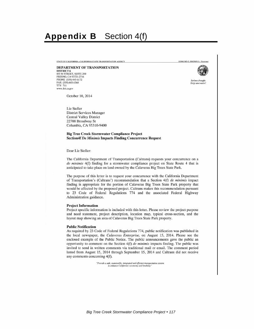
Big Tree Creek Stormwater Compliance Project 117
Appendix B Section 4(f)
Appendix B 4(f)
Big Tree Creek Stormwater Compliance Project 118

Appendix C Comments and Responses
This appendix contains the comments received during the public circulation period
from August 15, 2014 to September 15, 2014. A Caltrans response follows each
comment presented.
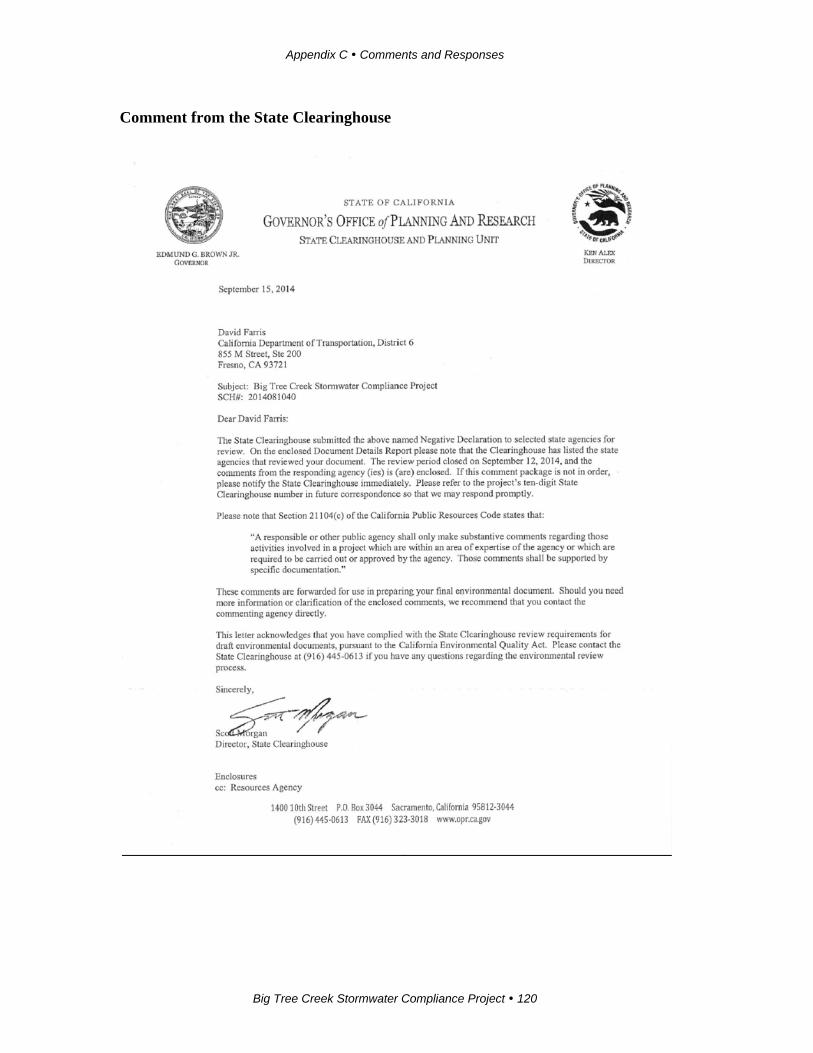
Appendix C Comments and Responses
Big Tree Creek Stormwater Compliance Project 120
Comment from the State Clearinghouse
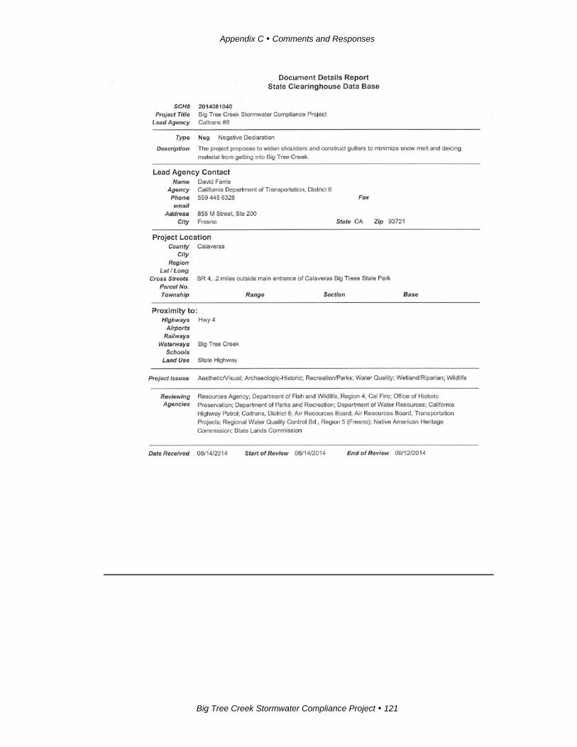
Appendix C Comments and Responses
Big Tree Creek Stormwater Compliance Project 121

Appendix C Comments and Responses
Big Tree Creek Stormwater Compliance Project 122
Response: Thank you for acknowledging Caltrans’ compliance with the California
Environmental Quality Act requirements as stated in the State Clearinghouse
guidelines. Caltrans has recorded the corresponding State Clearinghouse number for
this project.
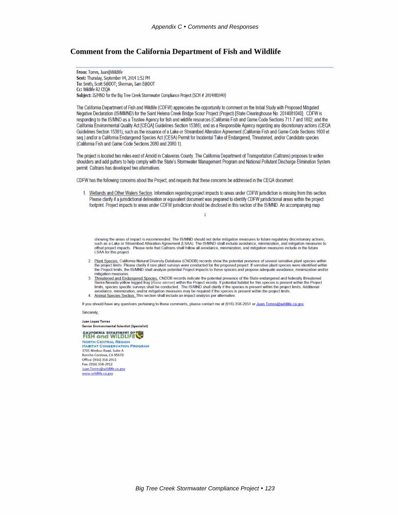
Appendix C Comments and Responses
Big Tree Creek Stormwater Compliance Project 123
Comment from the California Department of Fish and Wildlife
Appendix C Comments and Responses
Big Tree Creek Stormwater Compliance Project 124
Responses:
1. A jurisdictional delineation concluded that federal and state jurisdictional waters
under Section 401 and 404 of the Clean Water Act and Section 1602 of the Fish and
Wildlife Code are present within the biological study area. Project-related activities
have the potential to permanently impact up to 0.2 acre of jurisdictional waters. Five
culverts within the project limits would need to be replaced. This work would be
impacting unnamed temporary drainages that intersect State Route 4 within the
project limits. There would be no temporary impacts to these drainages. Impacts
would require coordination with the U.S. Army Corps of Engineers, Regional Water
Quality Control Board, and the California Department of Fish and Wildlife.
Big Tree Creek would be avoided during construction, and there would be no
permanent impacts to the creek. With implementation of best management practices,
temporary impacts are not expected to occur. Impacts to habitat next to Big Tree
Creek would require coordination with the California Department of Fish and
Wildlife.
2. Plant species were discussed in the Natural Environment Study; the fact that the
project has no impacts on plant species was noted at the beginning of Chapter 2.
Surveys have been conducted regularly in the Calaveras Big Trees State Park, and no
Small’s southern clarkia and yellow-lip pansy monkeyflower populations have been
observed. Because habitat within the project area is similar to that in the Calaveras
Big Tree State Park, it is unlikely that these plant species are present. According to
the Natural Environment Study, a botanical survey was done in the summer of 2010
and these sensitive plant species were not found. A list of plant species observed
during the botanical surveys is presented in Appendix H of the Nature Environment
Study. For the reasons listed above, it is not expected that these plant species are
likely to occur within the project area. Therefore, avoidance and minimization, and
mitigation measures are not being proposed. As a precautionary measure, a botanical
survey to confirm the findings of this report would be conducted prior to construction.
3. These issues are addressed in Section 2.3.3 Animal Species. As indicated in the
Natural Environment Study the project is outside the range of the Sierra Nevada
yellow-legged frog.

Appendix C Comments and Responses
Big Tree Creek Stormwater Compliance Project 125
4. Both alternatives have the same impacts to animal species. This point has been
added to the impacts section of the animal species discussion (Section 2.3.3).
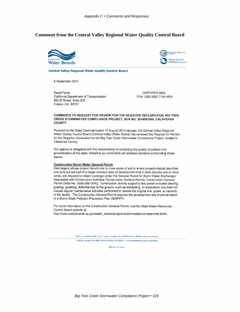
Appendix C Comments and Responses
Big Tree Creek Stormwater Compliance Project 126
Comment from the Central Valley Regional Water Quality Control Board
Appendix C Comments and Responses
Big Tree Creek Stormwater Compliance Project 127

Appendix C Comments and Responses
Big Tree Creek Stormwater Compliance Project 128

Appendix C Comments and Responses
Big Tree Creek Stormwater Compliance Project 129
Responses:
Caltrans will obtain a Construction Stormwater Permit and a Clean Water Act 404
permit prior to construction. The remaining permits do not apply to this project.

Big Tree Creek Stormwater Compliance Project 131
Appendix D Title VI Policy Statement

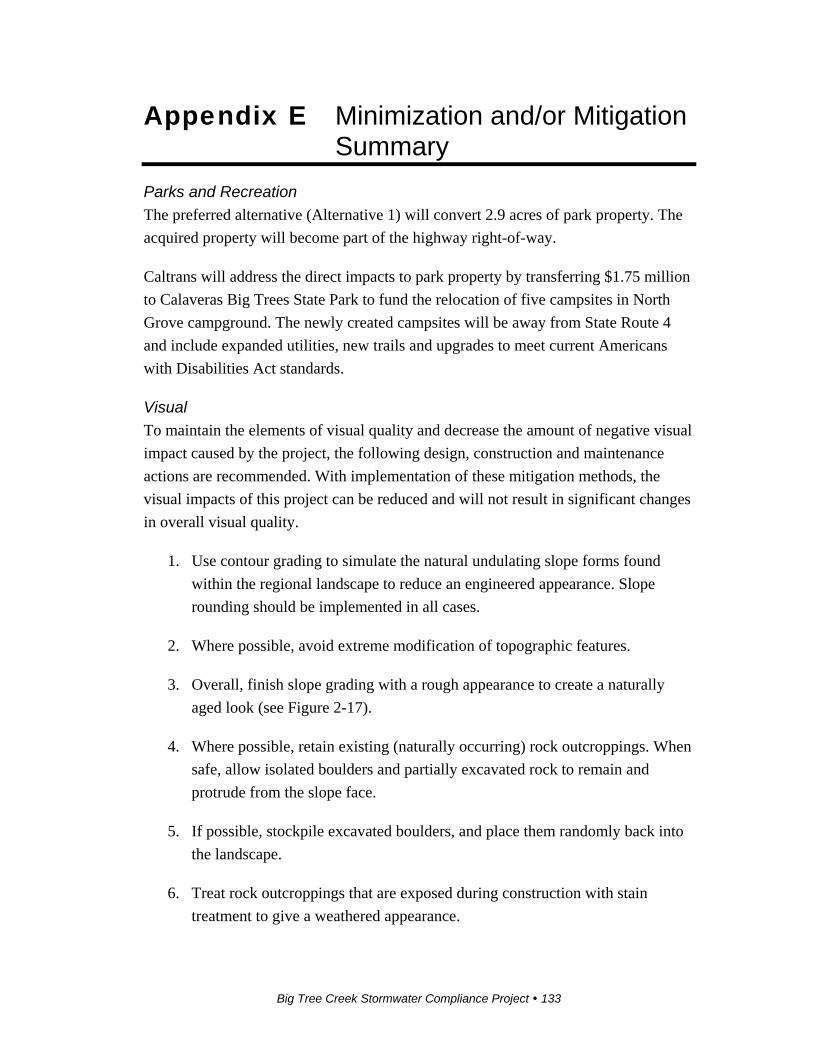
Big Tree Creek Stormwater Compliance Project 133
Appendix E Minimization and/or Mitigation Summary
Parks and Recreation
The preferred alternative (Alternative 1) will convert 2.9 acres of park property. The
acquired property will become part of the highway right-of-way.
Caltrans will address the direct impacts to park property by transferring $1.75 million
to Calaveras Big Trees State Park to fund the relocation of five campsites in North
Grove campground. The newly created campsites will be away from State Route 4
and include expanded utilities, new trails and upgrades to meet current Americans
with Disabilities Act standards.
Visual
To maintain the elements of visual quality and decrease the amount of negative visual
impact caused by the project, the following design, construction and maintenance
actions are recommended. With implementation of these mitigation methods, the
visual impacts of this project can be reduced and will not result in significant changes
in overall visual quality.
1. Use contour grading to simulate the natural undulating slope forms found
within the regional landscape to reduce an engineered appearance. Slope
rounding should be implemented in all cases.
2. Where possible, avoid extreme modification of topographic features.
3. Overall, finish slope grading with a rough appearance to create a naturally
aged look (see Figure 2-17).
4. Where possible, retain existing (naturally occurring) rock outcroppings. When
safe, allow isolated boulders and partially excavated rock to remain and
protrude from the slope face.
5. If possible, stockpile excavated boulders, and place them randomly back into
the landscape.
6. Treat rock outcroppings that are exposed during construction with stain
treatment to give a weathered appearance.
Appendix E Minimization and/or Mitigation Summary
Big Tree Creek Stormwater Compliance Project 134
7. Where possible, flatten slopes in locations where trees do not exist. In no case
should excavation be performed in proximity to a tree where the end result
leaves exposed tree roots. If tree roots are exposed, the tree should be
completely removed.
8. As much as possible, excavate slopes to minimize tree removal.
9. Revegetate all disturbed soil areas after recontouring the landform.
10. Replace removed trees and understory where possible.
11. Replant with native species as much as possible. The Caltrans District
Biologist and Landscape Architect shall work with the Calaveras Big Trees
State Park biologist to determine appropriate revegetation species.
12. Undulate or feather the perimeter of tree groupings to increase the natural
appearance.
13. Vary plant spacing for a more natural appearance.
14. Where possible to implement, save appropriate number of felled trees and
boulders and naturally place them at random locations on disturbed areas to
create an aged appearance, as determined by the Caltrans Landscape
Architecture Department.
15. Collect, stockpile, and reapply duff to the excavated slopes to reduce the
newly constructed look and to promote natural revegetation.
16. Apply erosion control to all disturbed soil areas.
17. Erosion control seed species, origin and application strategy shall be
determined by Caltrans Landscape Architects in consultation with Caltrans
District Biologists, and Calaveras Big Trees State Park.
18. Where possible, construct proposed structural elements using natural or
textured natural-appearing materials (such as sculpted boulders, rocks,
retaining walls, manufactured stone veneers and/or wood textured products) to
best match the surrounding visual character.
19. Contour grading at the base of retaining walls should be naturalistic and
designed with fill material to reduce the overall height and scale of the wall
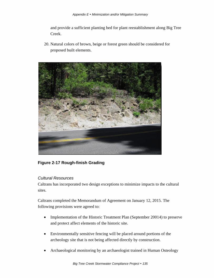
Appendix E Minimization and/or Mitigation Summary
Big Tree Creek Stormwater Compliance Project 135
and provide a sufficient planting bed for plant reestablishment along Big Tree
Creek.
20. Natural colors of brown, beige or forest green should be considered for
proposed built elements.
Figure 2-17 Rough-finish Grading
Cultural Resources
Caltrans has incorporated two design exceptions to minimize impacts to the cultural
sites.
Caltrans completed the Memorandum of Agreement on January 12, 2015. The
following provisions were agreed to:
Implementation of the Historic Treatment Plan (September 20014) to preserve
and protect affect elements of the historic site.
Environmentally sensitive fencing will be placed around portions of the
archeology site that is not being affected directly by construction.
Archaeological monitoring by an archaeologist trained in Human Osteology

Appendix E Minimization and/or Mitigation Summary
Big Tree Creek Stormwater Compliance Project 136
and a Native American monitor during ground-disturbing activities at the
following locations:
o The area within the proposed right-of-way between the western and
eastern boundaries of locus 2 of the archaeological site.
o The area within the proposed right-of-way between the western and
eastern boundaries of locus 1 of the archaeological site.
o The area within the proposed right-of-way between the western and
eastern boundaries of locus 3 of the archaeological site.
Cultural Resource Sensitivity Training shall be required for all personnel
working on the project during construction. Participating Native American
members shall deliver a Cultural Resources Sensitivity Training video for use
when an archaeologist and Native American monitor are not available to
deliver training.
An agreement between interested Native American Tribes and Caltrans for the
final treatment of the two bedrock milling station features of the
archaeological site will be developed for review, comment, and
implementation.
Caltrans shall with the coordination of the participating Tribes of Calaveras
Band of the Mi-Wuk, Washoe Tribe of Nevada and California, and Miwok
develop a Monitoring Agreement and Treatment of the Bedrock Milling
Station feature.
It is Caltrans’ policy to avoid cultural resources whenever possible. If buried cultural
materials are encountered during construction, it is Caltrans’ policy to stop work in
the area until a qualified archaeologist can evaluate the nature and significance of the
find.
If human remains are discovered, State Health and Safety Code Section 7050.5 states
that further disturbances and activities shall cease in any area or nearby area
suspected to overlie remains, and the County Coroner contacted. Pursuant to
California Public Resources Code Section 5097.98, if the remains are thought to be
Native American, the coroner will notify the Native American Heritage Commission,
which will then notify the Most Likely Descendent. At this time, the person who
discovered the remains would contact the Resident Engineer so that he or she could
Appendix E Minimization and/or Mitigation Summary
Big Tree Creek Stormwater Compliance Project 137
work with the Most Likely Descendent on the respectful treatment and disposition of
the remains. Further provisions of Public Resources Code 5097.98 are to be followed
as applicable.
Water Quality
Best management practices will be required because a soil disturbance area greater
than 1 acre is anticipated. The following will be required:
A notice of intention will be submitted to the appropriate regional water
quality control board at least 30 days prior to start of construction.
A stormwater pollution prevention plan will be prepared and implemented
during construction to the satisfaction of resident engineer. The plan will be
approved by Caltrans prior to start of construction. Caltrans will then submit
the plan to the Regional Water Quality Board for approval.
A notice of termination shall be submitted to the regional water quality control board
on completion of construction and site stabilization. A project will be considered
complete when the criteria for final stabilization defined in the construction general
board permit are met.
Biology – Habitats
Riparian
Caltrans will obtain a Streambed Alteration Agreement (1602) from the California
Department of Fish and Wildlife. The Streambed Alteration Agreement will be
obtained before beginning construction. Proposed mitigation for riparian habitat will
replace permanently affected habitat by a ratio of 3 to 1. This mitigation can be done
either though payment of fees to a riparian mitigation fund, preservation or
enhancement of offsite habitat (if available), or by enhancing riparian habitat within
Calaveras Big Trees State Park.
The following avoidance and minimization measures will be implemented before and
during construction:
Limit removal of riparian vegetation to the minimum amount necessary to
allow for efficient project construction.
Minimize the amount of riparian vegetation removed by installing
environmentally sensitive area fencing at the outer edge of the work area on
Appendix E Minimization and/or Mitigation Summary
Big Tree Creek Stormwater Compliance Project 138
the south side of State Route 4 before any ground disturbance or other
construction-related activities. The fencing will be clearly delineated on the
final contract plans. Any encroachment beyond the fencing will be prohibited.
The project’s special provision package will provide clear language regarding
acceptable fencing material and prohibited construction-related activities,
vehicle operation, material and equipment storage, and other surface-
disturbance activities within sensitive areas.
Montane Hardwood Conifer
The following avoidance and minimization measures will be implemented before and
during construction:
Limit removal of conifer habitat to the minimum necessary to allow for efficient
project construction.
Install high-visibility fencing outside of the drip line of the vegetation adjacent to
the work areas within this habitat to make clear the environmentally sensitive
area. Any encroachment beyond the environmentally sensitive area fencing
during construction will be prohibited. The environmentally sensitive area
fencing will be clearly delineated on the final contract plans. The project’s
special provision package will provide clear language regarding acceptable
fencing material and prohibited construction-related activities, vehicle operation,
material and equipment storage, and other surface-disturbance activities within
sensitive areas.
Biology – Animal Species
California Spotted Owl
The following avoidance and minimization measures would be implemented:
6. Conduct a second protocol-level survey within the spring and summer prior to
construction. If active nest sites are observed, data collected from this survey
will aid in minimizing and avoiding impacts to nesting owls during project
construction, which will be done in coordination with the California
Department of Fish and Wildlife.
7. Retain a qualified biologist prior to construction and any ground disturbance
activities to conduct an education program that includes a description of the
California spotted owl and general protection measures to be implemented to
protect the species.
Appendix E Minimization and/or Mitigation Summary
Big Tree Creek Stormwater Compliance Project 139
8. Assign a qualified biologist to conduct a pre-construction survey at least 14
days prior to any ground disturbance or other construction-related activities. If
nests are identified, a Caltrans biologist, in coordination with the California
Department of Fish and Wildlife, will determine how to proceed.
9. Establish a no-disturbance buffer of 500 feet around active nests identified
during pre-construction surveys to avoid disturbance or destruction of the nest
until after the breeding season, or until a biological monitor determines that
the young have fledged.
10. Provide a qualified biologist to monitor the project during construction
activities that may affect the species to ensure that the California spotted owl
is not affected by the proposed project.
Northern Goshawk
The following avoidance and minimization measures will be implemented:
6. Conduct a second protocol-level survey within the spring and summer prior to
construction. If active nest sites are observed, data collected from this survey
will aid in minimizing and avoiding impacts to nesting northern goshawks
during project construction.
7. Retain a qualified biologist prior to construction and any ground disturbance
activities to conduct an education program that includes a description of the
northern goshawk and general protection measures to be implemented to
protect the species.
8. Assign a qualified biologist to conduct a pre-construction survey at least 14
days prior to any ground disturbance or other construction-related activities.
9. Establish a no-disturbance buffer of 500 feet around active nests identified
during pre-construction surveys to avoid disturbance or destruction of the nest
until after the breeding season, or until a biological monitor determines that
the young have fledged.
10. Provide a qualified biologist to monitor the project during construction
activities that may affect the species to ensure that the northern goshawk is not
affected by the project.
Appendix E Minimization and/or Mitigation Summary
Big Tree Creek Stormwater Compliance Project 140
Foothill Yellow-legged Frog
The following avoidance and minimization measures will be implemented prior to
and during construction:
8. Implement erosion control and slope stabilization best management practices,
as defined in the project’s stormwater pollution prevention plan.
9. Minimize the amount of vegetation removed.
10. Assign a qualified biologist to conduct an education program before
construction and any ground disturbance activities. This education/training
program shall include a description of the foothill yellow-legged frog and
general protection measures to be implemented to protect the species.
11. Provide a qualified biologist to conduct a pre-construction survey at least 14
days prior to any ground disturbance or other construction-related activities.
12. Install environmentally sensitive area fencing at the outer edge of the work
area on the south side of State Route 4 prior to any ground disturbance or
other construction-related activities to protect foothill yellow-legged frog
habitat. This is designed to ensure construction staff stays outside the sensitive
areas. Any encroachment beyond the fencing during construction will be
prohibited. The fencing will be clearly delineated on the final contract plans.
The project’s special provision package will provide clear language regarding
acceptable fencing material and prohibited construction-related activities,
vehicle operation, material and equipment storage, and other surface-
disturbance activities within sensitive areas.
13. Install silt fencing at the outer edge of the work area on the south side of State
Route 4 to prevent any amphibians from entering the work area. The fence
shall be installed prior to any ground disturbance or other construction-related
activities and shall remain in place until construction is completed. This is to
prevent the species from getting into the construction site. Any encroachment
beyond the silt fencing during construction will be prohibited. The silt fencing
will be clearly delineated on the final contract plans.
14. Assign a qualified biologist to monitor the project during construction
activities that may affect the species and be responsible for ensuring that the
environmentally sensitive area fencing and silt fencing are not compromised
Appendix E Minimization and/or Mitigation Summary
Big Tree Creek Stormwater Compliance Project 141
and to otherwise ensure that the foothill yellow-legged frog is not affected by
the project.
Western Red Bat
The following avoidance and minimization measures will be implemented prior to
and during construction:
6. Minimize the amount of vegetation removed.
7. Assign a qualified biologist to conduct an education program before
construction and any ground disturbance activities. This education/training
program shall include a description of the western red bat and general
protection measures to be implemented to protect the bat.
8. Assign a qualified biologist to conduct a pre-construction survey at least 14
days prior to any ground disturbance or other construction-related activities.
9. Install environmentally sensitive area fencing at the outer edge of the work
area on the south side of State Route 4 prior to any ground disturbance or
other construction-related activities to protect western red bat habitat. Any
encroachment beyond the fencing during construction will be prohibited. The
fencing will be clearly delineated on the final contract plans. The project’s
special provision package will provide clear language regarding acceptable
fencing material and prohibited construction-related activities, vehicle
operation, material and equipment storage, and other surface-disturbance
activities within sensitive areas.
10. Provide a qualified biologist to monitor the project during construction
activities that may affect the species to ensure that the western red bat is not
affected by the project.
Migratory Birds
If vegetation removal is scheduled to occur during the nesting season (February 15 to
September 1), a qualified biologist shall conduct pre-construction surveys within
suitable nesting habitat in the biological area. The nesting bird surveys shall be
conducted within 14 days prior to ground disturbance. If no active nests are detected
during surveys, construction may proceed. If active nests are detected, then a no-
disturbance buffer shall be established around the nests identified during the pre-
construction survey. If common, that is, non-special-status birds are identified nesting

Appendix E Minimization and/or Mitigation Summary
Big Tree Creek Stormwater Compliance Project 142
on or adjacent to the project, a protective 100-foot buffer shall be established for non-
raptors, and a 300-foot buffer for raptors. No construction-related activities will be
allowed to occur within this buffer area until a qualified biologist confirms that the
nest is no longer active.

Big Tree Creek Stormwater Compliance Project 143
Appendix F SHPO Concurrence
Appendix E SHPO Concurrence
Big Tree Creek Stormwater Compliance Project 144

Appendix E SHPO Concurrence
Big Tree Creek Stormwater Compliance Project 145

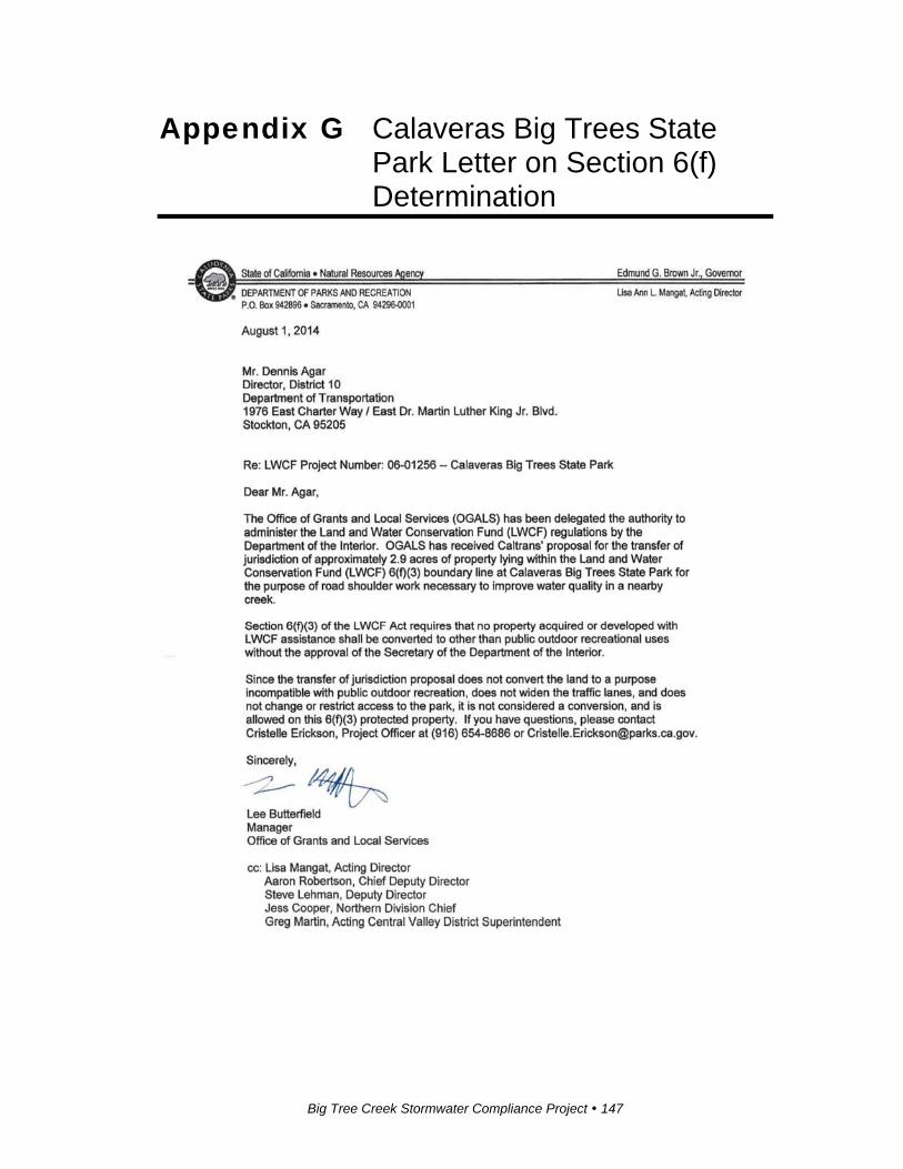
Big Tree Creek Stormwater Compliance Project 147
Appendix G Calaveras Big Trees State Park Letter on Section 6(f) Determination
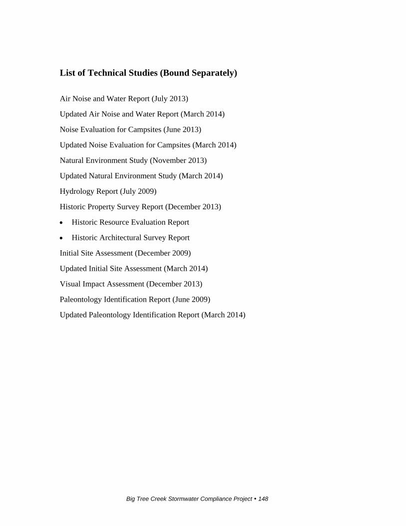
Big Tree Creek Stormwater Compliance Project 148
List of Technical Studies (Bound Separately)
Air Noise and Water Report (July 2013)
Updated Air Noise and Water Report (March 2014)
Noise Evaluation for Campsites (June 2013)
Updated Noise Evaluation for Campsites (March 2014)
Natural Environment Study (November 2013)
Updated Natural Environment Study (March 2014)
Hydrology Report (July 2009)
Historic Property Survey Report (December 2013)
Historic Resource Evaluation Report
Historic Architectural Survey Report
Initial Site Assessment (December 2009)
Updated Initial Site Assessment (March 2014)
Visual Impact Assessment (December 2013)
Paleontology Identification Report (June 2009)
Updated Paleontology Identification Report (March 2014)