Embed Size (px)
Citation preview
Initial Study/Mitigated Negative Declaration
Marin Sanitary Services Facility (MSS)
Master Use Permit, Development Plan, Zoning Amendments,
Jacoby Street Right-of-Way Vacation and Abandonment &
Golden Gate Bridge Highway & Transportation District
Property Zoning Amendment Project
The MSS facilities are located at Andersen Drive and the terminus of Jacoby Street (1050
Andersen Drive and 535-565 Jacoby Street), San Rafael, CA.
Assessor’s Parcel No.’s: 018-180-72, -73, -74, -75 & -76
The subject Golden Gate Bridge Highway & Transportation District property lies west of
the MSS facilities, south of Jacoby Street and SMART rail right of way, San Rafael, CA.
Assessor’s Parcel No.: 018-141-03
Lead Agency:
City of San Rafael
Community Development Department
1400 Fifth Avenue (P.O. Box 151560)
San Rafael, CA 94915-1560
Contact: Kraig Tambornini, Senior Planner
Monday, May 18, 2015
TABLE OF CONTENTS
ENVIRONMENTAL CHECKLIST .....................................................................................................................27
EXHIBITS ...............................................................................................................................................................43
ENVIRONMENTAL FACTORS POTENTIALLY AFFECTED .....................................................................45
DETERMINATION ...............................................................................................................................................45
EVALUATION OF ENVIRONMENTAL IMPACTS ........................................................................................46
I. AESTHETICS ..............................................................................................................................46 II. AGRICULTURE AND FOREST RESOURCES .........................................................................51 III. AIR QUALITY .............................................................................................................................53 IV. BIOLOGICAL RESOURCES ......................................................................................................64 V. CULTURAL RESOURCES .........................................................................................................68 VI. GEOLOGY AND SOILS ..............................................................................................................76 VII. GREENHOUSE GAS EMMISSIONS .........................................................................................79 VIII. HAZARDS AND HAZARDOUS MATERIALS .........................................................................83 IX. HYDROLOGY AND WATER QUALITY ..................................................................................86 X. LAND USE AND PLANNING ....................................................................................................90 XI. MINERAL RESOURCES ............................................................................................................92 XII. NOISE ..........................................................................................................................................92 XIII. POPULATION AND HOUSING .................................................................................................95 XIV. PUBLIC SERVICES ....................................................................................................................97 XV. RECREATION .............................................................................................................................99 XVI. TRANSPORTATION/TRAFFIC ...............................................................................................100 XVII. UTILITIES AND SERVICE SYSTEMS ....................................................................................102 XVIII. MANDATORY FINDINGS OF SIGNIFICANCE.....................................................................105
SOURCE REFERENCES ....................................................................................................................................108
PROJECT SPONSOR’S INCORPORATION OF MITIGATION MEASURES ..........................................110
DETERMINATION FOR PROJECT ................................................................................................................110
Notice of Intent 3 Marin Sanitary Services Facility – Master Use Permit Amendment
DATE: Monday, May 18, 2015
TO: Public Agencies, Organizations and Interested Parties
FROM: Kraig Tambornini, Senior Planner
SUBJECT: NOTICE OF PUBLIC REVIEW AND INTENT TO ADOPT A MITIGATED
NEGATIVE DECLARATION
Pursuant to the State of California Public Resources Code and the “Guidelines for Implementation of the
California Environmental Quality Act of 1970” as amended to date, this is to advise you that the Department
of Community Development of the City of San Rafael has prepared an Initial Study on the following
project:
Project Name: Marin Sanitary Services Facility (MSS) Master Use Permit, Development Plan and Zoning
Amendments
Location: Marin Sanitary Services Facility (MSS) is located on Andersen Drive and at the terminus of
Jacoby Street (1050 Andersen Drive and 535-565 Jacoby Street), San Rafael, Marin County, California, APNs:
018-180-72, -73, -74, -75 & -76. A separate vacant parcel leased by MSS and owned by the Golden Gate
Bridge District is located west of the MSS site, south of Jacoby Street and separated from Jacoby Street by
SMART rail right of way, at APN 018-141-03.
Property Description: The MSS project site is comprised of five (5) adjoining parcels located at the end of
Jacoby Street with approximately 82.15 acres in total area. The five parcels were established through prior
review and action by the Planning Division in 1995, at which time the Planning Division approved several lot
line adjustments to consolidate MSS buildings and facility operations, and designate the upper portion of the
site as private hillside open space area. Four (4) parcels are developed and used for MSS operations (Parcels A
– D). These parcels are relatively level and comprise 31.28 acres. The fifth parcel (Parcel E) is a densely
forested, 50.87 acre, hillside site with an average cross-slope of 39%. The upper slopes of the site include a
visually significant ridgeline, San Quentin Ridge, which also provides a boundary line for the San Rafael
corporate limits with the City of Larkspur. MSS also leases a separate 2.78 acre parcel to the west from
Golden Gate Bridge Highway and Transportation District. This property is undeveloped, subleased for storage
uses, and located across SMART rail right-of-way with access from Jacoby Street.
Marin Sanitary Service (MSS) has been providing municipal solid waste collection and recycling services to
the Marin community since 1948, currently serving over 33,000 residential and commercial accounts in nine
communities within Marin County. MSS provides residential and commercial trash pick-up, operates a transfer
station, recycling center, nonhazardous materials resource center, household hazardous waste collection
program, debris box rental, concrete and soil recovery, wood recovery, commercial food waste collection
program, and green waste composting operations. The MSS facility land use currently is permitted under
Notice of Intent 4 Marin Sanitary Services Facility – Master Use Permit Amendment
Master Use Permit UP96-8 issued by the City of San Rafael (amending prior UP92-7) and a Planned
Development (PD1580) zoning district. MSS waste management facility operations are also subject to strict
County and State regulations and permitting requirements, including those enforced by the California
Integrated Waste Management Board. Master use permit UP96-8, under which MSS is currently operating,
had consolidated 12 individual use permits which were previously issued by the City over the years for facility
operations and periodic expansions. The main buildings associated with MSS operations are located on Parcel
A, with additional operational activities and functions located on Parcels B through D.
Parcel B is primarily used for an interim public self-storage use; comprised of metal storage containers placed
on the open, paved and fenced yard area. This use is operated as “Rafael Storage”, and occupies work areas
that currently are not used or needed by MSS for its daily operations. There also is a small ancillary animal
keeping/husbandry area housing swine, which in the past has served as a method for disposing of food waste.
Wood storage has also been established in various outdoor site locations, which generally complement
recovery operations.
The current master use permit under which the site is operating (UP96-8) granted approval for up to 240
public storage containers to be placed on Parcel B, as an interim use of unused portions of the site. However,
additional public storage containers have been placed on both Parcel B and Parcel D, without benefit of
permits and approvals. This expansion of storage uses occurred between 1997 and 2005; resulting in a total of
797 containers installed on both parcels for the personal storage and contractor storage uses, as well as for
MSS facilities storage needs. There also is a permitted resource recovery and storage shed on Parcel D which
is used for MSS operations. Lastly, commercial sales of soils product transported to the site have been
permitted to occur on Parcel C, operated by A&S Landscape Materials, which complement MSS composting
and recovery operations (by providing supporting product sales to consumers).
Parcel E is a steep upsloping hillside area that terminates at a ridge to the south, which has been primarily
preserved and protected as a private open space. However, a maintenance shed has been previously permitted
in an area just south of Parcels C and D, which formerly was developed with an historic residential building.
The original house and site once were accessed from a stagecoach path that crossed the site from the east and
running west across the ridge, down toward the historic residence and then Jacoby Street. Over the past 15-20
years, the fire access roads and several large adjacent pad areas have been paved with concrete within Parcel
E. These areas were used to store and season cut wood, and other materials and equipment. Several storage
containers also encroached from Parcel B into Parcel E. There are several retaining walls that separate the
operational areas from the hillside open space areas. An unpermitted gabion constructed on Parcel C has been
subject to structural engineering review by the City Public Works Department (i.e., October 2006 plans and
engineering by Richard Jensen, engineer).
Following a minor upgrade to parking on Parcel A, the site provides parking spaces for 198 vehicles; with 158
spaces provided on Parcel A (Main operations office & industrial), 15 spaces on Parcel B (temporary mini-
storage uses), 18 spaces on Parcel C (soils products storage and sales), and 7 spaces on Parcel D (MSS
operations). The property also is crossed by right-of-way for a future extension of Jacoby Street. A small
portion of this right of way is improved, where it accesses the site from its west end. The remainder of this
right-of-way is not needed and has not been used for any public infrastructure. The roadway was previously
approved to be abandoned and vacated in 1984.
Project Description: The project involves a site rezoning and land use permit amendments to update the
existing Master Use Permit, Development Plan and Planned Development Zoning standards for the
approximately 82.15 acre Marin Sanitary Services (MSS) Waste Management facility; consisting of solid
waste disposal, transfer and resource and recovery operations, and open space lands. The project does not
propose to expand any of the current use areas of the site, but would update the current approvals, consolidate
boundary lines which would simplify any future development in existing work areas (which is anticipated to
respond to waste management industry needs and practices), and to legalize expanded interim storage uses.
Notice of Intent 5 Marin Sanitary Services Facility – Master Use Permit Amendment
The information provided with the amendment proposal includes A) a ‘Master Use Permit Amendment
Application’ packet (MSS, MUPA) which describes the project and operations in detail, and accompanying
technical reports that have been prepared to support the current amendment proposal, and B) project plans
titled ‘Marin Sanitary Service, Master Use Permit Amendment’ (MSS, MUP). Pertinent plan sheets have been
referenced within the Initial Study. A summary of project components and modified uses are as follows:
Golden Gate Bridge District Property Rezone. Remove property leased from Golden Gate Bridge
District, at APN 018-141-03 (across the SMART rail line, west of the MSS site) from the MSS
development plan and master use permit and rezone the site from PD 1580 to P/QP (see MSS, MUP Plan
Sheet A2.1). The District has indicated that it is not interested in pursuing a separate use permit for the
temporary outdoor storage uses on the site, and it intends to vacate the uses when the current leases expire
in 2015.
Marin Sanitary Service Rezoning. Rezone all five MSS facility parcels from Industrial “I” (Parcel A)
and Planned Development PD1580 (Parcels B through E) zoning designations to revised PD.
Marin Sanitary Service Development Plan & Use Permit. Re-designate the former lettered parcel areas
to use “Areas” A through E. Update the use permit to address the activities permitted within the lettered
use areas for MSS operational “work” Areas A through D, and open space uses in Area E. This includes
legalizing an increase in the number of public storage containers originally permitted on the site from 240
up to 682, resulting in a net reduction to the number of containers that have currently been placed and
occupied on the site by approximately 115 containers.
MSS is required to obtain additional building permits for construction of retaining walls built adjacent to
the open space boundary and make some minor physical site and infrastructure improvements, as follows;
a) install new fire lines and hydrants,
b) remove and relocate containers to maintain fire lanes,
c) install open space boundary fences and markers, and
d) install fencing and landscaping enhancements.
The master use permit amendment also recognizes the ongoing goals and need for MSS to address existing
and future waste reduction and resource recovery mandates and keep pace with industry innovation and
technology; which has been reflected in food waste diversion practices, change in onsite processing of
waste streams as well as curbside collection methods. As part of MSS ongoing recovery and waste
diversion efforts, MSS has realized a dramatic shift in the industry from waste hauling to conversion of
waste to energy (e.g., through Biomass Conversion and Anaerobic Digestion technologies). MSS recently
partnered with Central Marin Sanitation District to collect and deliver food waste to CMSD which convert
this material to energy on the CMSD site (which converted existing facility structures to food digesters
that produces methane which powers an on-site generator). MSS is also actively pursuing the ability in the
near future to divert and reduce waste sent to landfills by converting wood chips to energy on-site within
the existing permitted waste management facility areas using new technologies (e.g., Biomass
Conversion); that would be regulated by the Bay Area Air Quality Management District (BAAQMD) and
will be part of the current CalRecycle and County Health permits. A self-contained anaerobic digestion
unit to make renewable power from bio-methane generated from food and green waste will likely be
installed in the near future, which could supply up to 2.1 million kwh power per year to meet the entire
facility energy demand or up to 160,000 of gallons equivalents of renewable natural gas to fuel a fleet of
16 heavy-duty vehicles. The hours of operations of the Transfer Station and the proposed anaerobic
digestion facility will be harmonized to allow 24 hours activity to occur among the inter-related
technologies to allow the handling of organic feedstocks within the Transfer Station. The hours of
operations of MRRC and the proposed biomass conversion facility will also be harmonized to allow 24
hours activity to allow the handling of wood chips to the biomass conversion facility.
Notice of Intent 6 Marin Sanitary Services Facility – Master Use Permit Amendment
The operating hours are 24 hours per day and secure when the front gate is closed. The permitted hours of
Operation will be the following:
Waste Receipt: 12 a.m. to 4 p.m. 7 days per week
Site Operations: 5 a.m. to 12 a.m. 7 days per week
Transfer Station 24 hours 7 days per week
MRRC 24 hours 7 days per week
Anaerobic Digestion 24 hours 7 days per week
Biomass Conversion 24 hours 7 days per week
The Facility is open seven days a week year-round, and only closes on Thanksgiving, Christmas, New
Year’s Day and Easter.
The MSS proposed land use areas, including distribution and use of the storage containers (which is the
only change in existing permitted land use activities proposed as part of this amendment) would be as
follows (see MSS, MUP Plan Sheet A4):
Area A:
Approximately 12.2 acres at 1050 Andersen Drive containing the majority of the MSS waste
management facility buildings (i.e., recycling center, transfer stations, resource recovery, household
hazardous waste, metals and wood materials recovery, 16,173 square feet administrative and dispatch
offices including 6,466 square feet of office space and 9,707 square feet of warehouse, 72 covered
truck parking and loading docks, 8,400 square foot repair and maintenance shop and a truck washing
bay.)
Area B:
Approximately 5.12 acres south of Jacoby Street at the site entrance of Jacoby Street, proposing
legalization and expansion of public storage uses within this area (aka, Rafael Storage), , and an
existing interim small animal husbandry pen housing approximately 50 barnyard animals (pigs, goats,
horses) used for stripping yard waste. The animal keeping and public storage container uses include
the following characteristics:
Animal Keeping Use
The following operating conditions apply to the animal keeping activity:
o Animal waste is removed from the site, on a weekly or bi-weekly basis.
o The area animal keeping area is maintained with fresh straw/woodchips and sawdust.
Public Storage Container Use
The modular public (and MSS facility private) container storage activities are considered a long-term
interim uses, and the areas used for container storage are reserved for future MSS facility operations;
including but not limited to inert processing, materials storage, recycling and ancillary sales of
materials. The existing baseline public container storage use in Area B:
Existing Public Storage (per current use permit): 240 containers (38,400 sf container area)
Proposed Public Storage (to legalize): 155 containers (25,234 sf container area)
Total: 395 containers (63,634 sf container area)
It should be noted that 75 containers (11,120 sf of container storage area) are currently located in Area
B, which are proposed to be removed as part of this request to legalize the expansion of public storage
use on the property.
Notice of Intent 7 Marin Sanitary Services Facility – Master Use Permit Amendment
Area C:
Approximately 5.92 acres just east of Area A and Area B, used for inert processing operations
including concrete recycling recovery and bulk storage of soil products, fire wood storage above a
gabion wall, and ancillary sales of materials associated with and in support of recovery operations.
Area D:
Approximately 8.03 acres used for inert processing operations including bulk storage and soil
recycling, legalization of modular container storage units for MSS and public self-storage/contractor,
and a 10,200 square foot Resource Recovery and Storage building. Container storage areas are
considered a long-term interim use and the area is reserved for future operational uses. Ancillary sales
of materials associated with and in support of recovery operations is also a part of operations. The
container storage in this area contain the following characteristics:
Storage Containers
Public Storage (to remain/legalize): 233 containers (37,120 sf container area)
MSS Operations: 54 containers (8,840 sf container area)
The project would include the removal of 40 containers that are currently being used for public storage
in this area (6,320 sf of container storage). Thus, the combined public storage use in both Area B and
Area D, if approved, would increase the permitted container use from 240 containers (38,400sf) to 682
containers. This translates into a net increase in total permitted public storage containers by 442
containers (62,354sf of container area).
Area E:
Approximately 50.87 acres as private hillside open space, south of the operational “work” areas A
through D. This parcel contains paved fire roads, limited grazing, bee and animal keeping, and a 1,886
square foot storage shed. Non-permitted seasonal fire wood storage has been eliminated.
Marin Sanitary Service Lot Consolidation & Open Space Boundary. Consolidate all five of the
adjacent MSS facility Parcels A through E as one legal lot of record (see MSS MUP Plan Sheet A3, C4.1
and C4.2) and adjust the open space boundary for Area E as shown on the development plan map to reflect
existing encroachments with no net change in open space area lands, remove unpermitted uses and
activities, and install gates and markers to clearly demarcate the open space boundary. The consolidation
would make the property consistent with floor area ratio standards contained in General Plan 2020. (see
MSS MUP Plan Sheet A3).
Open Space Improvements. Legalize 265,000 square feet of concrete paving placed on the fire roads and
creating excess paved areas throughout the private open space Area E (current Parcel E) (see MSS MUP
Plan Sheet C1.2). Potential for removal of 104,700 square feet of concrete paving has been identified and
evaluated (2,600 cubic yards) (see MSS MUP Plan Sheet C1.3). Several existing small animal keeping
operations and small structures would remain.
Parking Upgrades. Upgrade on-site parking from the current 198 spaces to 228 total spaces (see MSS
MUP Plan Sheet A5).
Jacoby Street Right of Way Abandonment & Vacation. Abandon a 60-foot wide improved portion of
Jacoby Street that extends past an existing gate access into the site and incorporate this roadway as part of
the PD, grant new utility easements, and vacate remaining 30-foot wide unimproved and unutilized Jacoby
Street right of way (see MSS MUP Plan Sheet C2.1).
Drainage, Landscape and Utility Improvements. Install new drainage improvements, stormwater bio-
swales and landscape improvements (see MSS MUP Plan Sheets C1.1, C3.1, and L1A through L2.1).
Provide improved fire protection for the site, including a new 8” fire line extending from Andersen Drive
with three new fire hydrants in Area D, and installation of a four new fire hydrants and 8” fire line serving
Area C (see MSS MUP Plan Sheet A5). The use of the site as a waste management facility is also subject
Notice of Intent 8 Marin Sanitary Services Facility – Master Use Permit Amendment
to ongoing storm water monitoring of its industrial activities by the State Water Resources Control Board.
The project would include further upgrades to the site’s stormwater pollution prevention plan and program
as part of the local land use permit amendments.
Zoning Entitlements and Other Permits:
The project requires a PD Zoning District Amendment, Use Permit, Environmental and Design Review Permit
and Subdivision (Lot Line Adjustment/Consolidation) zoning entitlement actions, and a right of way
abandonment and vacation action by the City Council. Subsequent building, grading and encroachment
permits would be required to implement proposed site work proposed, which would be established as a
condition of project approval.
As noted, in addition to local Planning review of land use permits by the City Planning Division, and the City
Fire Department, Public Works and Building Division requirements, the waste management facility is also
subject to regulation and permitting by the following agencies:
State Water Resources Control Board
California Integrated Waste Management Board
CalRecycle
Bay Area Air Quality Management District
Regional Water Quality Control Board
Marin County Environmental Health
Environmental Issues:
Potentially significant impacts have been identified in Air Quality, Biological Resources, Cultural Resources,
and Hazards; which may occur as a result of the changes that have been made to existing facility use areas and
the site improvements required to address these changes. Traffic impacts also have been identified with
standard mitigation required for additional traffic trips generated from existing expanded public storage
container uses. All potentially significant project impacts would be mitigated to a less-than-significant level
through implementation of recommended mitigation measures or through compliance with existing Municipal
Code requirements or City standards. Recommended measures are summarized in the attached Mitigation
Monitoring and Reporting Plan (MMRP) and Initial Study/Mitigated Negative Declaration. The Initial
Study/Mitigated Negative Declaration document has been prepared in consultation with local, and state
responsible and trustee agencies and in accordance with Section 15063 of the California Environmental
Quality Act (CEQA). Furthermore, the Initial Study/Mitigated Negative Declaration will serve as the
environmental compliance document required under CEQA for any subsequent phases of the project and for
permits/approvals required by a responsible agency.
A thirty-day (30-day) public review period is required for this project which is subject to local permit
authority for the updates to the current zoning entitlements and for regional and state permits from Responsible
Agencies. The public review period shall commence on Monday, May 18, 2015. Written comments must be
sent to the City of San Rafael, Community Development Department, Planning Division, 1400 Fifth Avenue,
San Rafael CA 94901 through Tuesday, June 23, 2015, 5:00 PM. The City of San Rafael Planning
Commission will hold a public hearing on the Initial Study/Mitigated Negative Declaration and project merits
on Tuesday, June 23, 2015, 7:00 PM in the San Rafael City Council Chambers at City Hall (address listed
above). Correspondence and comments can be delivered to Kraig Tambornini, project planner, phone:
(415) 485-3092, email: [email protected].
Mitigation Monitoring and Reporting Program 9 Marin Sanitary Services Facility - Master Use Permit Amendment
MITIGATION MONITORING AND REPORTING PROGRAM
Marin Sanitary Services Facility Rezone and Use Amendments Project
Mitigation Measure Implementation
Procedure
Monitoring
Responsibility
Monitoring /
Reporting
Action & Schedule
Non-Compliance
Sanction/Activity
Monitoring
Compliance
Record
(Name/Date)
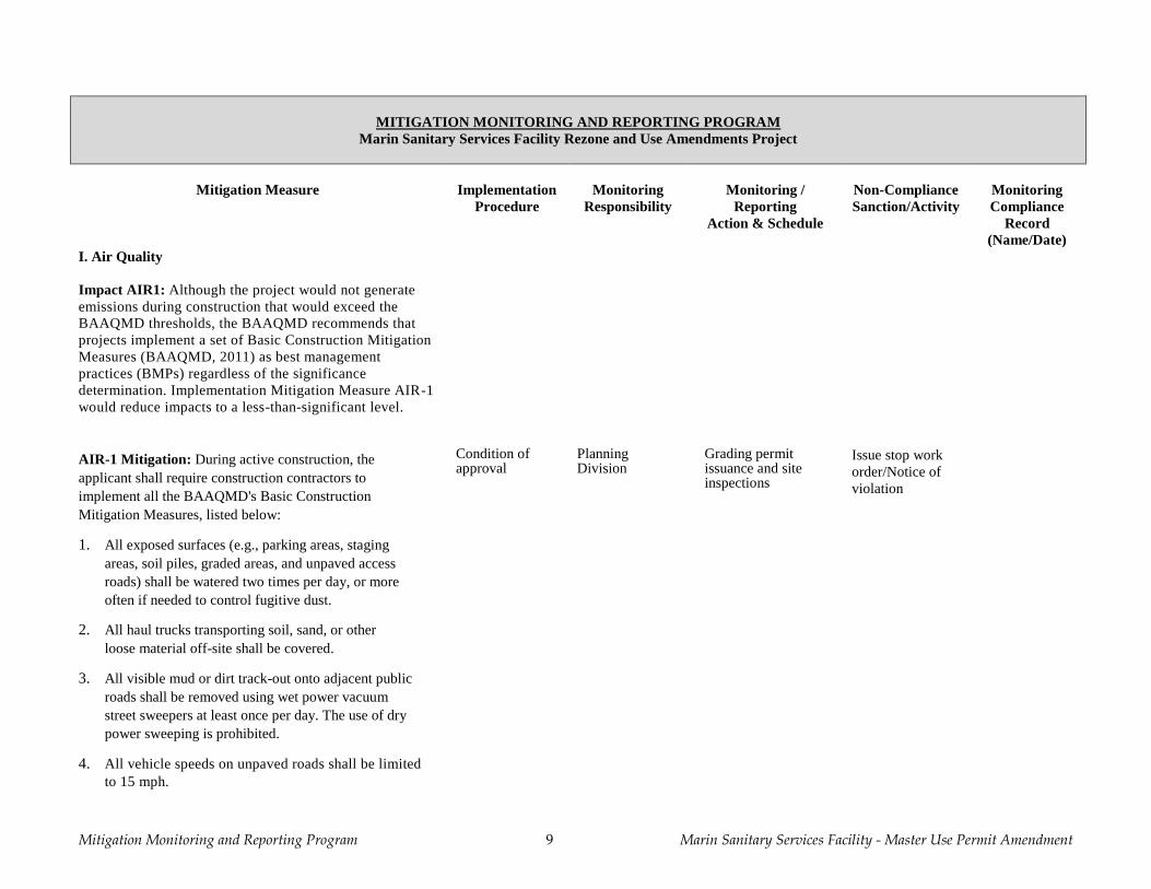
I. Air Quality
Impact AIR1: Although the project would not generate
emissions during construction that would exceed the
BAAQMD thresholds, the BAAQMD recommends that
projects implement a set of Basic Construction Mitigation
Measures (BAAQMD, 2011) as best management
practices (BMPs) regardless of the significance
determination. Implementation Mitigation Measure AIR-1
would reduce impacts to a less-than-significant level.
AIR-1 Mitigation: During active construction, the
applicant shall require construction contractors to
implement all the BAAQMD's Basic Construction
Mitigation Measures, listed below:
1. All exposed surfaces (e.g., parking areas, staging
areas, soil piles, graded areas, and unpaved access
roads) shall be watered two times per day, or more
often if needed to control fugitive dust.
2. All haul trucks transporting soil, sand, or other
loose material off-site shall be covered.
3. All visible mud or dirt track-out onto adjacent public
roads shall be removed using wet power vacuum
street sweepers at least once per day. The use of dry
power sweeping is prohibited.
4. All vehicle speeds on unpaved roads shall be limited
to 15 mph.
Condition of approval
Planning Division
Grading permit issuance and site inspections
Issue stop work
order/Notice of
violation

Mitigation Monitoring and Reporting Program 10 Marin Sanitary Services Facility - Master Use Permit Amendment
MITIGATION MONITORING AND REPORTING PROGRAM
Marin Sanitary Services Facility Rezone and Use Amendments Project
Mitigation Measure Implementation
Procedure
Monitoring
Responsibility
Monitoring /
Reporting
Action & Schedule
Non-Compliance
Sanction/Activity
Monitoring
Compliance
Record
(Name/Date)
5. All roadways, driveways, and sidewalks to be paved
shall be completed as soon as possible. Building pads
shall be laid as soon as possible after grading unless
seeding or soil binders are used.
6. Idling times shall be minimized either by shutting
equipment off when not in use or reducing the
maximum idling time to 5 minutes (as required by the
California airborne toxics control measure Title 13,
Section 2485 of California Code of Regulations
[CCR]). Clear signage shall be provided for
construction workers at all access points.
7. All construction equipment shall be maintained and
properly tuned in accordance with manufacturer's
specifications. All equipment shall be checked by a
certified mechanic and determined to be running in
proper condition prior to operation.
8. Post a publicly visible sign with the applicant's
telephone number and person to contact regarding dust
complaints. This person shall respond and take
corrective action within 48 hours. The Air District's
phone number shall also be visible to ensure
compliance with applicable regulations.
Impact AIR2: MSS is a facility regulated by CalRecycle
(e.g. landfill, composting, etc.) and required to have Odor
Impact Minimization Plan (OIMP) in place and have
procedures that establish fence line odor detection thresholds.
No impacts would result. A copy of the OIMP is provided in
Attachment A.
Mitigation Monitoring and Reporting Program 11 Marin Sanitary Services Facility - Master Use Permit Amendment
MITIGATION MONITORING AND REPORTING PROGRAM
Marin Sanitary Services Facility Rezone and Use Amendments Project
Mitigation Measure Implementation
Procedure
Monitoring
Responsibility
Monitoring /
Reporting
Action & Schedule
Non-Compliance
Sanction/Activity
Monitoring
Compliance
Record
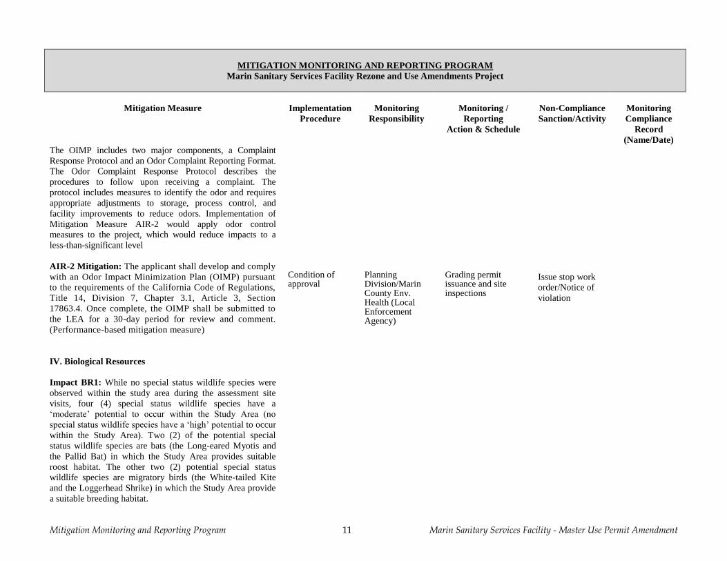
(Name/Date) The OIMP includes two major components, a Complaint
Response Protocol and an Odor Complaint Reporting Format.
The Odor Complaint Response Protocol describes the
procedures to follow upon receiving a complaint. The
protocol includes measures to identify the odor and requires
appropriate adjustments to storage, process control, and
facility improvements to reduce odors. Implementation of
Mitigation Measure AIR-2 would apply odor control
measures to the project, which would reduce impacts to a
less-than-significant level
AIR-2 Mitigation: The applicant shall develop and comply
with an Odor Impact Minimization Plan (OIMP) pursuant
to the requirements of the California Code of Regulations,
Title 14, Division 7, Chapter 3.1, Article 3, Section
17863.4. Once complete, the OIMP shall be submitted to
the LEA for a 30-day period for review and comment.
(Performance-based mitigation measure)
Condition of approval
Planning Division/Marin County Env. Health (Local Enforcement Agency)
Grading permit issuance and site inspections
Issue stop work
order/Notice of
violation
IV. Biological Resources
Impact BR1: While no special status wildlife species were
observed within the study area during the assessment site
visits, four (4) special status wildlife species have a
‘moderate’ potential to occur within the Study Area (no
special status wildlife species have a ‘high’ potential to occur
within the Study Area). Two (2) of the potential special
status wildlife species are bats (the Long-eared Myotis and
the Pallid Bat) in which the Study Area provides suitable
roost habitat. The other two (2) potential special status
wildlife species are migratory birds (the White-tailed Kite
and the Loggerhead Shrike) in which the Study Area provide
a suitable breeding habitat.
Mitigation Monitoring and Reporting Program 12 Marin Sanitary Services Facility - Master Use Permit Amendment
MITIGATION MONITORING AND REPORTING PROGRAM
Marin Sanitary Services Facility Rezone and Use Amendments Project
Mitigation Measure Implementation
Procedure
Monitoring
Responsibility
Monitoring /
Reporting
Action & Schedule
Non-Compliance
Sanction/Activity
Monitoring
Compliance
Record
(Name/Date) Though the biological resource assessment determined the
grassland and woodland habitat within the Study Area
provides a low-quality habitat to support the four (4) special
status wildlife species, compliance with recommended
Mitigation Measures Biological Resource-1 through
Biological Resource-4 would reduce the potential threat to
roosting bats or breeding birds to a less-than-significant
level.
BR-1 Mitigation: Any tree removal or trimming work shall
take place between September 1st and October 31
st, which
falls outside the breeding bird window and avoids both the
maternity and hibernation period for bats. Tree removal can
take place during this period without a breeding bird or bat
roost survey. This does not include removing fallen trees,
which can be removed at any time.
Condition of approval
Planning Division
Grading permit issuance and site inspections
Issue stop work
order/Notice of
violation
BR-2 Mitigation: If brush clearing or ground disturbance is
required within the Study Area, these activities shall be
conducted outside of the breeding bird season which begins
February 1st and lasts through August 31
st.The exception is
for clearing weedy brush, such as French broom, that
overhangs existing fire roads. Brush may be removed to the
outer extent of the road at any time of the year without pre-
construction surveys, if the road is regularly disturbed by
active traffic. Removal of brush outside the outer edge of the
road or on roads not regularly disturbed by active traffic
should have pre-construction surveys.
Condition of
approval
Planning
Division
Grading permit
issuance and site
inspections
Issue stop work
order/Notice of
violation
BR-3 Mitigation: In the event that initial ground
disturbance, vegetation removal or construction cannot be
scheduled outside the breeding bird season (February
through August), a wildlife biologist shall conduct a breeding
Condition of
approval
Planning
Division
Grading permit
issuance and site
inspections
Issue stop work
order/Notice of
violation
Mitigation Monitoring and Reporting Program 13 Marin Sanitary Services Facility - Master Use Permit Amendment
MITIGATION MONITORING AND REPORTING PROGRAM
Marin Sanitary Services Facility Rezone and Use Amendments Project
Mitigation Measure Implementation
Procedure
Monitoring
Responsibility
Monitoring /
Reporting
Action & Schedule
Non-Compliance
Sanction/Activity
Monitoring
Compliance
Record
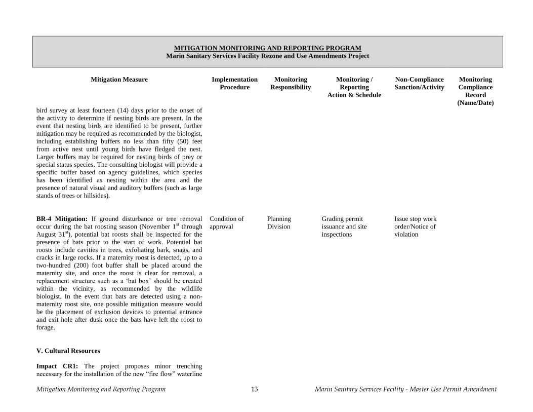
(Name/Date) bird survey at least fourteen (14) days prior to the onset of
the activity to determine if nesting birds are present. In the
event that nesting birds are identified to be present, further
mitigation may be required as recommended by the biologist,
including establishing buffers no less than fifty (50) feet
from active nest until young birds have fledged the nest.
Larger buffers may be required for nesting birds of prey or
special status species. The consulting biologist will provide a
specific buffer based on agency guidelines, which species
has been identified as nesting within the area and the
presence of natural visual and auditory buffers (such as large
stands of trees or hillsides).
BR-4 Mitigation: If ground disturbance or tree removal
occur during the bat roosting season (November 1st through
August 31st), potential bat roosts shall be inspected for the
presence of bats prior to the start of work. Potential bat
roosts include cavities in trees, exfoliating bark, snags, and
cracks in large rocks. If a maternity roost is detected, up to a
two-hundred (200) foot buffer shall be placed around the
maternity site, and once the roost is clear for removal, a
replacement structure such as a ‘bat box’ should be created
within the vicinity, as recommended by the wildlife
biologist. In the event that bats are detected using a non-
maternity roost site, one possible mitigation measure would
be the placement of exclusion devices to potential entrance
and exit hole after dusk once the bats have left the roost to
forage.
Condition of
approval
Planning
Division
Grading permit
issuance and site
inspections
Issue stop work
order/Notice of
violation
V. Cultural Resources
Impact CR1: The project proposes minor trenching
necessary for the installation of the new “fire flow” waterline
Mitigation Monitoring and Reporting Program 14 Marin Sanitary Services Facility - Master Use Permit Amendment
MITIGATION MONITORING AND REPORTING PROGRAM
Marin Sanitary Services Facility Rezone and Use Amendments Project
Mitigation Measure Implementation
Procedure
Monitoring
Responsibility
Monitoring /
Reporting
Action & Schedule
Non-Compliance
Sanction/Activity
Monitoring
Compliance
Record
(Name/Date) from Andersen Drive to Area D. While no site
improvements, including grading or excavation, are proposed
within Area E, the project’s proposed minor trenching
operations may disturb unknown cultural resources. Based
on the cultural resource evaluation for the project, it is
recommended that standard mitigation measures should be
incorporated. Compliance with recommended Mitigation
Measures Cultural Resources-1, -2, -3 and -4 would ensure
that disturbance of recorded or unknown cultural resources
during project’s excavation, grading and construction
activities would be reduced to a less-than-significant level.
CR-1 Mitigation: To mitigate potential damage to any
recorded cultural resource during grading, excavation or soil
disturbance activities in the vicinity of any recorded cultural
resource, including activities to remove concrete
improvements to the existing fire road network,
archaeological investigation should be undertaken to
determine the exact boundary of the remaining deposit, the
condition of the remaining deposit and the potential for
significance of the archaeological site. A Native American
monitor should also be present. The procedures to follow for
archaeological and Native American monitoring of a cultural
resource site are presented in Cultural Resources mitigation
measures CR-2 and CR-3.
Condition of
approval
Planning
Division,
Building, Public
Works
Grading permit
issuance and site
inspections
Issue stop work
order/Notice of
violation
CR-2 Mitigation: To mitigate potential damage to any
recorded cultural resource during grading, excavation or soil
disturbance activities in the vicinity of any recorded cultural
resource, archaeological monitoring shall occur, based on the
following procedures:
Monitoring will consist of directly watching the
major excavation process. Monitoring will occur
during the entire work day and will continue on a
daily basis unit the depth of excavation has been
Condition of
approval
Planning
Division,
Building, Public
Works
Grading permit
issuance and site
inspections
Issue stop work
order/Notice of
violation
Mitigation Monitoring and Reporting Program 15 Marin Sanitary Services Facility - Master Use Permit Amendment
MITIGATION MONITORING AND REPORTING PROGRAM
Marin Sanitary Services Facility Rezone and Use Amendments Project
Mitigation Measure Implementation
Procedure
Monitoring
Responsibility
Monitoring /
Reporting
Action & Schedule
Non-Compliance
Sanction/Activity
Monitoring
Compliance
Record
(Name/Date) reached at which the cultural resource no longer is
present. This depth is estimated as usually five feet
(5’) below existing grade but may require
modification as determined by the monitoring
archaeologist and the observed soil conditions.
Spot checks will consist of partial monitoring the
progress of excavation over the course of the
project. Monitoring all spoils materials, open
excavation, recently grubbed areas, and other soil
disturbances will be inspected. The frequency and
duration of spot checks will be based on the relative
sensitivity of the exposed soils and active work
areas. The monitoring archaeologist shall determine
the relative sensitivity of the cultural resource site.
If prehistoric human interments (human burials) are
encountered within the native soils of the cultural
resource site, all work shall be halted in the
immediate vicinity of the find. The County Coroner,
project superintendent, and the project planner (or a
representative of the Lead Agency, the City of San
Rafael Community Development Department,
Planning Division) shall be contacted immediately.
The procedures to be followed at this point are
prescribed by law.
If significant cultural deposits other than human
burials are encountered, the project shall be
modified to allow the artifacts or features to be left
in place, or the archaeological consultant shall
undertake the recovery of the deposit or feature.
Significant cultural deposits are defined as
archaeological artifacts or features that associate
with the prehistoric period, the historic era Mission
and Pueblo Periods and the American era up to
1900.
Mitigation Monitoring and Reporting Program 16 Marin Sanitary Services Facility - Master Use Permit Amendment
MITIGATION MONITORING AND REPORTING PROGRAM
Marin Sanitary Services Facility Rezone and Use Amendments Project
Mitigation Measure Implementation
Procedure
Monitoring
Responsibility
Monitoring /
Reporting
Action & Schedule
Non-Compliance
Sanction/Activity
Monitoring
Compliance
Record
(Name/Date)
Whenever the monitoring archaeologist determines
that potentially significant remains or human burials
have been encountered, the piece of equipment that
encounters the suspected deposit will be stopped,
and the excavation inspected by the monitoring
archaeologist. If the suspected remains prove to be
non-significant or non-cultural in origin, work shall
recommence immediately. If the suspected remains
prove to be part of a significant deposit, all work
shall be halted in that location until removal has
been completed. If human remains are found, the
County Coroner (or designated representative) shall
be contacted to evaluate the discovered remains and
implement proper contacts with pertinent Native
American representatives through the Native
American Heritage Commission (NAHC).
Equipment stoppages shall only involve those
pieces of equipment that have actually encountered
significant or potentially significant deposits, and
should not be construed to mean a stoppage of all
equipment on the site unless the cultural resource
deposit covers the entire site.
During temporary equipment stoppages brought
about to examine suspected remains, the monitoring
archaeologist shall accomplish the necessary tasks
in due speed.
CR-3 Mitigation: To mitigate potential damage to any
recorded cultural resource during grading, excavation or soil
disturbance activities in the vicinity of any recorded cultural
resource, Native American monitoring shall occur whenever
archaeological monitoring is required or whenever
prehistoric Native American cultural deposits are
encountered or discovered. As recommended by the Native
Condition of
approval
Planning
Division,
Building, Public
Works
Grading permit
issuance and site
inspections
Issue stop work
order/Notice of
violation
Mitigation Monitoring and Reporting Program 17 Marin Sanitary Services Facility - Master Use Permit Amendment
MITIGATION MONITORING AND REPORTING PROGRAM
Marin Sanitary Services Facility Rezone and Use Amendments Project
Mitigation Measure Implementation
Procedure
Monitoring
Responsibility
Monitoring /
Reporting
Action & Schedule
Non-Compliance
Sanction/Activity
Monitoring
Compliance
Record
(Name/Date) American Heritage Commission (NAHC), the Native
American monitoring consultant shall have the following
knowledge and abilities:
Knowledge of local historic and prehistoric Native
American village sites, culture, religion, ceremony
and burial practices.
Knowledge and understanding of California Health
and Safety Code Section 7050.5 and California
Public Resources Code Section 5097.9 et al.
Ability to effectively communicate the meaning of
Health and Safety Code Section 7050.5 and Public
Resources Code Section 5097.9 et al. to Marin
Sanitary Services (MSS) representatives, including
property owners, site managers, contractors and
subcontractors, Native Americans, City of San
Rafael Planning staff, and archaeological
monitoring representatives.
Ability to work well with local law enforcement
officials and the NAHC to ensure the return of all
associated grave goods taken from a Native
American grave during grading, excavation or soil
disturbance activities.
Ability to travel to known cultural resource sites
within the traditional tribal territory.
Knowledge and understanding of California
Environmental Quality Act (CEQA) Guidelines,
Section 15064.5 and Section 106 of the National
Historic Preservation Act of 1966 (NHPA), as
amended.
Ability to advocate for the preservation in place of
Native American cultural features through
knowledge and understanding of CEQA mitigation
measures, as stated in CEQA Guidelines Section
15126.4(b)(A)(B), and through knowledge and
Mitigation Monitoring and Reporting Program 18 Marin Sanitary Services Facility - Master Use Permit Amendment
MITIGATION MONITORING AND REPORTING PROGRAM
Marin Sanitary Services Facility Rezone and Use Amendments Project
Mitigation Measure Implementation
Procedure
Monitoring
Responsibility
Monitoring /
Reporting
Action & Schedule
Non-Compliance
Sanction/Activity
Monitoring
Compliance
Record
(Name/Date) understanding of Section 106 of the NHPA.
Ability to read topographic maps and be able to
locate known cultural resource sites and reburial
locations for future inclusion in the NAHC Sacred
Lands Inventory.
Knowledge and understanding of archaeological
practices, including the phases of archaeological
investigation.
The Native American monitoring consultant is required to:
Ensure the presence of a Native American monitor
during all earth disturbing activities in the vicinity
of any recorded cultural resource or whenever
prehistoric Native American cultural deposits are
encountered or discovered.
Communicate orally and in writing with the
archaeological monitoring consultant, City of San
Rafael Planning staff, representatives for MSS
representatives, including property owners, site
managers, contractors and subcontractors, and any
Native American organizations. The Native
American monitoring consultant will be responsible
for communicating any observations or
recommendations to any Native American
organizations, neighborhood groups, or individuals
that have contacted the City of San Rafael to request
listing. The contact list will be supplied to the
Native American monitor.
Maintain a daily log of activities and file a report
with the MSS representatives on each day that a
Native American monitor is present.
Prepare progress reports on any ‘findings’ and
summarize the observations and recommendations
made in the daily reports (i.e., human remains,
Mitigation Monitoring and Reporting Program 19 Marin Sanitary Services Facility - Master Use Permit Amendment
MITIGATION MONITORING AND REPORTING PROGRAM
Marin Sanitary Services Facility Rezone and Use Amendments Project
Mitigation Measure Implementation
Procedure
Monitoring
Responsibility
Monitoring /
Reporting
Action & Schedule
Non-Compliance
Sanction/Activity
Monitoring
Compliance
Record
(Name/Date) associated grave goods, non-human bone fragments,
beads, arrow points, and other artifacts). The
progress reports will be submitted monthly or at the
completion of all approved earth disturbing
activities.
Prepare a final written report at the completion of
all approved earth disturbing activities,
summarizing the observations and recommendations
of the daily and monthly reports and making
recommendations for future activities and
procedures on the MSS site, as appropriate. The
final report should describe the monitoring process,
the discovery any Native American human remains
and associated grave goods, and their final
disposition. This report shall contain, at a minimum,
the following information for each discovery of
human remains and associated grave goods:
o Date of each find
o Description of remains and associated grave
goods
o Date of reburial, and the geographical located
of reburial, including traditional site name if known
The final report shall include a discussion of
mitigation measures taken to preserve or protect
Native American cultural features and shall be
submitted to the archaeological monitoring
consultant, MSS representatives, the City of San
Rafael Planning staff, and the NAHC at the
completion of all approved earth disturbing
activities. Information from the report may be
included in the NAHC Sacred Lands Inventory.
Demonstrate the ability to identify archaeological
deposits and potential areas of impact.
Mitigation Monitoring and Reporting Program 20 Marin Sanitary Services Facility - Master Use Permit Amendment
MITIGATION MONITORING AND REPORTING PROGRAM
Marin Sanitary Services Facility Rezone and Use Amendments Project
Mitigation Measure Implementation
Procedure
Monitoring
Responsibility
Monitoring /
Reporting
Action & Schedule
Non-Compliance
Sanction/Activity
Monitoring
Compliance
Record
(Name/Date)
Work with the Most Likely Descendant (MLD) if
human remains are encountered. A MLD will be
chosen by the NAHC if human remains are
encountered. There is no guarantee that the Native
American monitoring consultant will be named as
the MLD. The chosen Native American monitoring
consultant must be able to communicate with the
MLD effectively, and to aid in carrying out any
procedures or tasks undertaken or recommended by
the MLD.
CR-4 Mitigation: In the absence of specific
recommendations made by the archaeological monitoring
consultant, the following general procedures shall be
implemented during the finding of an artifact (i.e., any item
or object over fifty years of age):
All contractors and subcontractors shall be required
to inform all of their employees that no artifacts are
to be removed from the area of the ‘find’ except
through authorized procedures.
Any artifacts found at or near a recorded cultural
resource are to be turned over to, or brought to the
immediate attention of, the archaeological
monitoring consultant. In the absence of the
archaeological monitoring consultant, the artifact
shall be delivered to the Native American
monitoring consultant, MSS representatives (i.e.,
property owners, site managers, contractor and
subcontractor supervisors) or the City of San Rafael
Planning staff.
Whenever any artifact is found or reported, a tag
should be included that indicates the following
information:
o The identity of the finder and the date of
Condition of
approval
Planning
Division,
Building, Public
Works
Grading permit
issuance and site
inspections
Issue stop work
order/Notice of
violation
Mitigation Monitoring and Reporting Program 21 Marin Sanitary Services Facility - Master Use Permit Amendment
MITIGATION MONITORING AND REPORTING PROGRAM
Marin Sanitary Services Facility Rezone and Use Amendments Project
Mitigation Measure Implementation
Procedure
Monitoring
Responsibility
Monitoring /
Reporting
Action & Schedule
Non-Compliance
Sanction/Activity
Monitoring
Compliance
Record
(Name/Date) discovery
o The identify of the responsible individual to
who the artifact is given
o A description of the location where the artifact
was found, the approximate distance and
direction to the nearest measuring point,
identification point on the project plans, or
other reliable, accurate method of locating.
o A description of the artifact that will allow it to
be identified if the tag and the artifact are
separated.
The artifact, if portable, should be transported to a
safe location where it can be kept until it can be
inspected by the archaeological monitoring
consultant.
CR-5 Mitigation: In the event of the accidental discovery of
historical or unique archaeological resources accidentally
discovered during construction or recognition of any human
remains in any location other than a dedicated cemetery,
there shall be no further excavation or disturbance of the site
or any nearby area reasonably suspected to overlie adjacent
human remains until:
1. In the event of accidental discovery of potential
resources an immediate evaluation of the find shall be
conducted by a qualified archaeologist. If the find is
determined to be an historical or unique archaeological
resource, contingency funding and a time allotment
sufficient to allow for implementation of avoidance
measures or appropriate mitigation should be available.
Work could continue on other parts of the building site
while historical or unique archaeological resource
mitigation takes place.
Condition of
approval
Planning
Division,
Building, Public
Works
Grading permit
issuance and site
inspections
Issue stop work
order/Notice of
violation
Mitigation Monitoring and Reporting Program 22 Marin Sanitary Services Facility - Master Use Permit Amendment
MITIGATION MONITORING AND REPORTING PROGRAM
Marin Sanitary Services Facility Rezone and Use Amendments Project
Mitigation Measure Implementation
Procedure
Monitoring
Responsibility
Monitoring /
Reporting
Action & Schedule
Non-Compliance
Sanction/Activity
Monitoring
Compliance
Record
(Name/Date) 2. In the event of discovery of human remains, the coroner
of the county in which the remains are discovered must
be contacted to determine that no investigation of the
cause of death is required. If the coroner determines the
remains to be Native American:
a. The coroner shall contact the Native American
Heritage Commission within 24 hours.
b. The Native American Heritage Commission
shall identify the person or persons it believes
to be the most likely descended from the
deceased Native American.
c. The most likely descendent may make
recommendations to the landowner or the
person responsible for the excavation work, for
means of treating or disposing of, with
appropriate dignity, the human remains and any
associated grave goods as provided in Public
Resources Code Section 5097.98, or
d. Where the following conditions occur, the
landowner or his authorized representative shall
rebury the Native American human remains
and associated grave goods with appropriate
dignity on the property in a location not subject
to further subsurface disturbance.
i. The Native American Heritage
Commission is unable to identify a
most likely descendent or the most
likely descendent failed to make a
recommendation within 24 hours after
being notified by the commission.
ii. The descendant identified fails to
make a recommendation; or
iii. The landowner or his authorized
representative rejects the
recommendation of the descendant,
Mitigation Monitoring and Reporting Program 23 Marin Sanitary Services Facility - Master Use Permit Amendment
MITIGATION MONITORING AND REPORTING PROGRAM
Marin Sanitary Services Facility Rezone and Use Amendments Project
Mitigation Measure Implementation
Procedure
Monitoring
Responsibility
Monitoring /
Reporting
Action & Schedule
Non-Compliance
Sanction/Activity
Monitoring
Compliance
Record
(Name/Date) and the mediation by the Native
American Heritage Commission fails
to provide measures acceptable to the
landowner.
VIII. Hazards and Hazardous Materials
Impact HAZ1: Unconfined mixtures of methane in air are
not explosive; however, a flammable concentration within
an enclosed space in the presence of an ignition source can
explode. Methane is buoyant at atmospheric temperatures
and disperses rapidly in air. Unintentional releases of
biogas from the facility could pose risks to human health
and safety. For example, biogas could be released from a
leak or rupture at the digester facility. If the gas reaches a
combustible mixture and an ignition source is present, a
fire and/or explosion could occur, resulting in possible
injuries and/or deaths.
Compliance with existing safety regulations and widely-
accepted industry standards would minimize the hazard to
the public and the environment. With respect to the flaring of
biogas and potential fire hazards associated with the storage
and transport of methane and small quantities of other
materials used in operations, the National Fire Protection
Association (NFPA) has established standards for fire
protection which would be applicable to the construction of
the AD facilities. These standards have been successfully
implemented by numerous waste water treatment facilities
across the country. Construction and operation of the project
would be required to comply with the California fire code
and local building codes (including requirements for the
installation of fire suppression systems). Standard safety
measures for anaerobic treatment facility construction and
operation that would minimize the potential for risks from
Mitigation Monitoring and Reporting Program 24 Marin Sanitary Services Facility - Master Use Permit Amendment
MITIGATION MONITORING AND REPORTING PROGRAM
Marin Sanitary Services Facility Rezone and Use Amendments Project
Mitigation Measure Implementation
Procedure
Monitoring
Responsibility
Monitoring /
Reporting
Action & Schedule
Non-Compliance
Sanction/Activity
Monitoring
Compliance
Record
(Name/Date) unintentional releases of biogas include leak detection
systems, warning signals, and safety flares to reduce excess
gas capacity. If released to the environment, methane would
be dispersed rapidly in air, minimizing the hazards of
exposure.
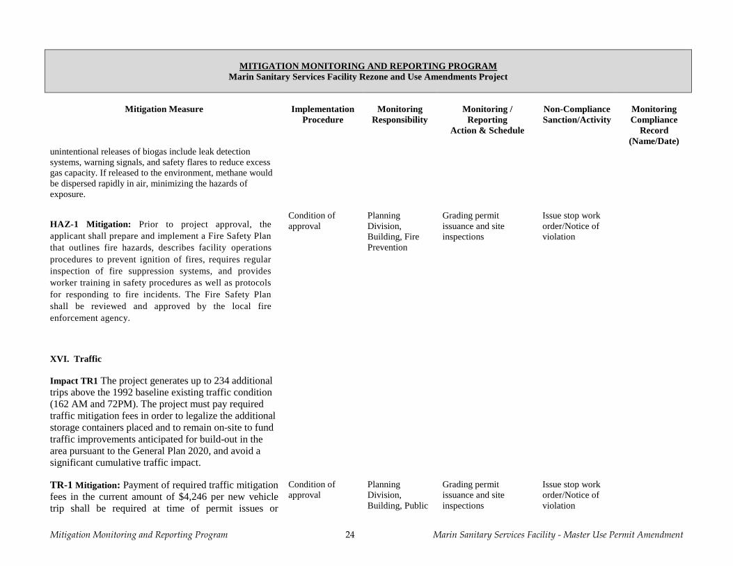
HAZ-1 Mitigation: Prior to project approval, the
applicant shall prepare and implement a Fire Safety Plan
that outlines fire hazards, describes facility operations
procedures to prevent ignition of fires, requires regular
inspection of fire suppression systems, and provides
worker training in safety procedures as well as protocols
for responding to fire incidents. The Fire Safety Plan
shall be reviewed and approved by the local fire
enforcement agency.
Condition of
approval
Planning
Division,
Building, Fire
Prevention
Grading permit
issuance and site
inspections
Issue stop work
order/Notice of
violation
XVI. Traffic
Impact TR1 The project generates up to 234 additional
trips above the 1992 baseline existing traffic condition
(162 AM and 72PM). The project must pay required
traffic mitigation fees in order to legalize the additional
storage containers placed and to remain on-site to fund
traffic improvements anticipated for build-out in the
area pursuant to the General Plan 2020, and avoid a
significant cumulative traffic impact.
TR-1 Mitigation: Payment of required traffic mitigation
fees in the current amount of $4,246 per new vehicle
trip shall be required at time of permit issues or
Condition of
approval
Planning
Division,
Building, Public
Grading permit
issuance and site
inspections
Issue stop work
order/Notice of
violation
Mitigation Monitoring and Reporting Program 25 Marin Sanitary Services Facility - Master Use Permit Amendment
MITIGATION MONITORING AND REPORTING PROGRAM
Marin Sanitary Services Facility Rezone and Use Amendments Project
Mitigation Measure Implementation
Procedure
Monitoring
Responsibility
Monitoring /
Reporting
Action & Schedule
Non-Compliance
Sanction/Activity
Monitoring
Compliance
Record
(Name/Date)
commencement of operations.
Works
Mitigation Monitoring and Reporting Program 26 Marin Sanitary Services Facility - Master Use Permit Amendment
[This page intentionally left blank]
Environmental Checklist Form 27 Marin Sanitary Services Facility – Master Use Permit Amendment
ENVIRONMENTAL CHECKLIST
1. Project Title Marin Sanitary Services Facility, Master Use Permit and
Development Plan Amendment
2. Lead Agency Name & Address City of San Rafael
Community Development Department, Planning Division
1400 Fifth Avenue (P.O. Box 151560)
San Rafael, California 94915-1560
3. Contact Person & Phone Number Kraig Tambornini, Senior Planner
Phone number: # (415) 485-3092
Email: [email protected]
4. Project Location The site is located in the City of San Rafael, Marin County,
California at the end of Jacoby Street (1050 Andersen Drive and
535-565 Jacoby Street), Assessor’s Parcel No’s. (APN) 018-180-
72, -73, -74, -75 and -76. A separate parcel that is leased by MSS
from Golden Gate Transit District is located west of the MSS site,
south of Jacoby Street and separated from Jacoby Street by
SMART rail right of way, at APN 018-141-03. (Refer to Exhibit
A, “Vicinity Map”).
5. Project Sponsor's Name & Address
Project Sponsor
Marin Sanitary Services, Inc.
565 Jacoby Street
San Rafael, CA 94901
Sponsor’s Representative
Fred Divine
Fredric C. Divine Associates, Architects
1924 Fourth Street
San Rafael, CA 94901
6. General Plan Designation Industrial (APNS: 018-180-72, -73, -74 & -75 / APN 018-141-03)
; and,
Conservation (APN: 018-180-76)
7. Zoning Industrial (APN: 018-180-72); Planned Development (APNS:
018-180-73, -74 & -75 and 018-141-03); and, Public/Open Space
(APN: 018-180-76)
8. Description of Project
Setting and Background
The Marin Sanitary Service (MSS) site is comprised of five (5) adjoining parcels located at the terminus of
Jacoby Street, with approximately 82.15 acres in total area. Four (4) of the parcels (Parcels A – D) are developed
and used by MSS for its facility operations. These parcels are flat and comprise 31.28 acres. The fifth parcel
(Parcel E) is a densely forested, approximately 50.87 acre hillside site with an average cross-slope of 39%. The
Environmental Checklist Form 28 Marin Sanitary Services Facility – Master Use Permit Amendment
MSS site is generally located at Jacoby Street, south of Andersen Drive, east of highway 101 and south of I-580.
In addition, MSS leases a long and narrow 2.78 acre sloped parcel parallel to highway 101 from the Golden Gate
Bridge Highway & Transportation District (GGBHTD), to the west of its primary operations that it uses for
outdoor storage (APN 018-141-03) which is currently a part of the MSS Master Plan. This property is
undeveloped land which is separated from the MSS facility by the SMART railroad right-of-way, and accessed
from Jacoby Street. See Initial Study Source Reference 6 - MSS MUP Amendment plan sheets A1 & A2.1 and
Source Reference 7 - Project Description.
Jacoby Street is a short, 60’-wide, city-maintained, surface street accessed by Andersen Drive, which terminates
directly at the site. The public right-of-way (ROW) for Jacoby Street currently continues from the end of
improved Jacoby Street through the site before returning to Andersen Drive east of the site. In 1984, the San
Rafael City Council (Resolution No. 6780) approved vacation of the unimproved portion of this public ROW,
which was never executed.
Since 1948, Marin Sanitary Service (MSS) has been providing municipal solid waste collection and recycling
services on the site serving over 33,000 residential and commercial accounts in nine communities within the
County. MSS provides residential and commercial waste pickup, operates a transfer station, recycling center, non-
hazardous materials resource center, household hazardous waste collection program, debris box rental, concrete
and soil recovery, wood resource recovery, commercial food waste program, and green waste composting
operations. The MSS site has a current land use approval from the City (UP96-8) and Planned Development
(PD1580) zoning district. In addition to local requirement for land use and building permits, the waste
management facility operations are further regulated by State, Regional and County agencies (i.e., State Water
Resources Board, California Department of Resources, Recycling and Recovery (CalRecycle), Regional Water
Quality Control Board and Marin County Environmental Health Services, acting as the Local Enforcement
Agency (LEA) for CalRecycle, and the Bay Area Air Quality Management District). These agencies establish
requirements to protect the public health and safety, as well as enforce mandates for the operator to effect
reductions in waste streams (through reuse, recycling and other efforts). MSS actively pursues innovations to
comply with waste recycling and landfill diversion mandates imposed by the State.
All of the buildings for the MSS operation are located on Parcel A, though some operational activity also occurs
on Parcels B through D. Parcel E is undeveloped and protected private open space. In 1993, the San Rafael
Planning Commission conditionally approved a Master Use Permit (UP92-007) that consolidated 12 separate Use
Permits issued for MSS operations. In 1996, this Master Use Permit was amended (UP96-008). The
characteristics and uses on each of the MSS parcels are provided below (see Source Reference 6, MSS MUP plan
sheets A2 through A5.3 and Source Reference 7, Project Description).
Parcel A (APN: 018-180-72)
Parcel A is approximately 12.2 acres in size, located between Andersen Drive and Jacoby Street, north of the
entrance to the MSS facility site. Currently, Parcel A has an Industrial (I) District zoning classification and an
Industrial (I) General Plan land use designation. The existing Master Use Permit allows concentration of MSS
facility structures and operations on this parcel, including the ‘Marin Recycling Center’, ‘MSS Transfer Station’,
‘Marin Resource Recovery Center’, ‘Marin Household Hazardous Waste Facility’, the former bio-gest machine,
food waste recycling, administrative offices, covered truck parking and repair services canopies or ports, a
machine and/or repair shop, storage, and on-site parking. These permanent building work areas total
approximately 237,716 square feet of gross floor area (not including 54,307 square feet of covered parking area);
resulting in a 0.45 floor area ratio (FAR) for this current parcel area). The buildings provide 2,770 square foot
administrative and dispatch office area, 72 covered truck parking and loading docks, 8,400 square foot shop and
maintenance building and truck wash bay. Current uses on the parcel are in substantial compliance with the
existing Master Use Permit. See MSS MUP Amendment Sheet A2 – Site Plan Existing Conditions. The Solid
Waste Facility Permit boundary of 8.5 acres includes the portions of Parcel A that encompasses all of the MSS
Environmental Checklist Form 29 Marin Sanitary Services Facility – Master Use Permit Amendment
Transfer Station and the Marin Resource Recovery, as well as the Jacoby Street access road, and a sliver of land
along Parcel B that includes portions of the animal husbandry facility.
Parcel B (APN: 018-180-73)
Parcel B is approximately 5.12 acres in size, located south of Jacoby Street, south of the vehicular entrance to the
MSS facility site. Currently, Parcel B has a Planned Development (PD 1580) District zoning classification and an
Industrial (I) General Plan land use designation. The existing Master Use Permit allows a 48-space parking lot, a
five-acre, fenced animal husbandry facility with pens and shelters for approximately 50 ‘barnyard animals,’
primarily, domestic pigs and fowl, and storage uses, including material storage, container storage, and contractor
storage. In 1997, the San Rafael Zoning Administrator through Environmental and Design Review Permit (ED96-
109) allowed 240 shipping containers for public self-storage use on the parking lot and surrounding contractor’s
storage area, with eight (8) parking spaces and street front fence and landscape screening. Current uses on the
parcel include 470 shipping containers used for public self-storage use. A 25’-wide Marin Municipal Water
District (MMWD) access and pipeline easement is located along the entire western property boundary line of
Parcel B, which connects to a 2.93-acre, MMWD parcel located upslope, immediately west and south of Parcel E.
Parcel C (APN: 018-180-74)
Parcel C is approximately 5.92 acres in size, located south of Parcel A and east of Parcel B, where Jacoby Street
terminates into the MSS site. Currently, Parcel C also has a Planned Development (PD 1580) District zoning
classification and an Industrial (I) General Plan land use designation. The existing Master Use Permit allows
primarily material composting and bulk storage, including inert or concrete processing. Current uses on the parcel
are in substantial compliance with the existing Master Use Permit. No structures exist on Parcel C.
Parcel D (APN: 018-180-75)
Parcel D is approximately 8.03 acres in size, located east of Parcel C, on the vacated or abandoned portion of the
Jacoby Street ROW. Currently, Parcel D also has a Planned Development (PD 1580) District zoning classification
and an Industrial (I) General Plan land use designation. Like Parcel C, the existing Master Use Permit allows
primarily material composting and bulk storage, and storage of equipment and debris off-haul containers or boxes.
In 2001, the San Rafael Zoning Administrator approved an Environmental and Design Review Permit (ED01-
134) to allow the construction of a storage shed, approximately 10,200 square feet in size, for use as storage for
the owner, housing historic military equipment, and as a resource and recovery building. Current uses on the
parcel include 327 shipping containers for public self-storage use/MSS use, and the resource recovery and storage
building. A 25’-wide, Pacific Gas & Electric (PG&E) overhead transmission line easement bisects Parcel D in a
north-south direction and continues upslope through Parcel E.
Parcel E (APN: 018-180-76)
Parcel E is approximately 50.87 acres in size, located upslope and south of Parcels A-D. Currently, Parcel E has a
Public/Open Space (P/OS) District zoning classification and a Conservation (C) General Plan land use
designation. It is listed in the San Rafael General Plan 2020 as a site once prioritized for open space purchase.
Parcel E is an undeveloped, forested, private open space hillside with a network of historic fire roads. The upper
slopes of Parcel E include a visually significant ridgeline, San Quentin Ridge (Bartel Ridge), which also provides
a southern boundary line for the San Rafael corporate limits with the City of Larkspur. The existing Master Use
Permit prohibits all development on Parcel E, except for animal grazing and small ancillary animal keeping
structures. Current uses on the parcel are in substantial compliance with the existing Master Use Permit, which
includes an existing legal nonconforming maintenance/storage structure approximately 1,886 square feet in size
located just above the border of Parcels C and D. This area as formerly occupied by an historic home that was
removed prior to issuance of the previous use permit and design approvals. Unpermitted container, dirt and wood
Environmental Checklist Form 30 Marin Sanitary Services Facility – Master Use Permit Amendment
storage has been removed from the site over the past several years, with a few remaining containers to be removed
near Parcel B. The network of existing fire roads have been improved with concrete and widened significantly in
portions of Parcel E. These are proposed to remain as paved access roads. Storage of materials and containers had
also occurred on this site, in conflict with zoning approvals, which since have been removed. A 25’-wide, Pacific
Gas & Electric (PG&E) overhead transmission line easement bisects Parcel E in a north-south direction. A 25’-
wide, Marin Municipal Water District (MMWD) access and pipeline easement is located along the western
property boundary line of Parcel E, which provides vehicular connection from Parcel B to the MMWD parcel
located immediately west and south of Parcel E.
Project Details
The project proposes to update the existing Master Use Permit 96-8 to allow MSS to continue to provide state-of-
the-art municipal solid waste collection and recycling services on the site while making needed site
improvements. The permitted daily tonnage and daily traffic amounts will not be increased as part of this project.
The site uses include waste management operations and interim public storage and soils sales uses, which are
compatible with or complement the existing site uses. The PD rezoning and use permit amendment would remove
the 2.78 acre Golden Gate Bridge District property, approved as separate outdoor storage site, from the MSS
facility operations and master use permit.
The PD zoning changes consist of text edits, with adjustment of the boundary to incorporate Parcel A, and move
the Golden Gate Bridge District property from PD to conventional zoning.
Physical changes that would occur as a result of the amendment and update to the MSS waste management
facility site and operations would include:
a) Adding an anaerobic digestion facility of up to 12,500 tons per year of food waste and green waste within
the footprint of MSS Transfer Station or as a stand-alone facility in the existing outdoor operations yard Parcel
C.
b) Adding a 1 mega-watt wood chip biomass conversion facility as a stand –alone facility in Parcel D.
c) Minor trenching for new fire lines and hydrants through the existing permitted work areas.
d) Removal of several of the unpermitted storage containers with adjustment made for containers proposed to
remain to provide adequate fire access lanes through the site.
e) Installation of permanent open space boundary markers to clearly delineate work areas from the open space
boundary. And,
f) Installation of minor fencing and landscaping enhancements to respond to changed conditions.
No other significant operational uses or expansion to the existing work areas are proposed or anticipated.
Subsequent local approvals would be required for issuance of grading and building permits would also be
required. Also, the local water district (MMWD) would require the applicant to obtain approval for extension of
water and fire suppression lines to serve those areas of the property currently not being adequately served. The
Solid Waste Facility Permit will need to be revised by County Environmental Health Services and concurred with
by CalRecycle to add the anaerobic digestion facility. The Bay Area Air Quality Management District
(BAAQMD) will need to issue an Authority to Construct and a Permit to Operate the food waste and green waste
anaerobic digestion facility and the wood chip biomass conversion facility, and also permits equipment and
machinery individually to mitigate potential air pollution from activities on the site with the issuances of Permits
to Operate, which are renewed annually.
The State Water Resources Control Board (SWRCB) requires a National Pollutant Discharge Elimination System
(NPDES) permit to demonstrate how non-point source discharge is handled on the property so that it won't pollute
the State's water resources. A Storm Water Pollution Prevention Plan (SWPPP) has been prepared and is located
on-site, with an Annual Report filed with the RWQCB.
Environmental Checklist Form 31 Marin Sanitary Services Facility – Master Use Permit Amendment
Applications submitted to the City for review and approval include the following:
1) PD Amendment. Rezone and approve an overall development plan for the entire MSS site (the San
Rafael General Plan 2020 requires Planned Development zoning for sites larger than five acres), and
separate the satellite parcel owned by the GGBHTD from the current PD zoning and master use permit.
2) Master Use Permit. Master Use Permit Amendment to add, update and revise the existing conditions of
approval for the operation of the MSS site and add the anaerobic digestion facility and the biomass
conversion facility. The GGBHTD parcel would not require any separate approvals or permits (existing
outdoor storage uses on this site would not be continued after the current lease expires in May 2015).
3) Environmental and Design Review Permit. Environmental and Design Review Permit to allow for the
site improvements proposed by the project, including parking and landscape improvements;
4) Lot Line Adjustment. Lot Line Adjustment to reflect consolidation of Parcels A, B, C, D and E;
5) Right of Way Abandonment & Vacation. Right of way vacation and abandonment for a portion of
Jacoby Street that lies beyond the main access gate to the facility, and for the remaining unused portion of
right of way; and
6) Utilities, Grading and Landscaping. Fire line and hydrant upgrades and utility easements and new
water line connections. Transmission lines are proposed to connect to the AD Facility and the biomass
conversion facility to the grid. A feed-in tariff is available for selling excess electricity back to utility
during off-peak periods.
The details of each zoning entitlement and the related site improvements are further described as follows:
Zoning Amendment (ZC09-001)
Currently, Parcel A is zoned Industrial (I) while the remaining Parcels B through E are regulated by an adopted
Planned Development District zoning (PD 1580). The amendment would bring the entire site within the same
zoning classification and subject to a single updated Master Use Permit that would regulate operational and open
space uses for the entire 82.15-acre MSS site. The project would essentially incorporate Parcel A into the current
PD District established for MSS. This would also help facilitate desired consolidation of the property and provide
for regulation of the entire site under a single zoning classification.
As part of the zone change, and consolidation of lots, the current ‘Parcel’ areas are proposed to be re-designated
on the land use plan as specific use ‘Areas’. The draft PD rezoning would replace the current PD 1580
development plan text and map designating the permitted industrial and open space uses of the site and areas, and
implementing the following development standards for the MSS site:
Floor Area:
Industrial use Areas A through D shall be subject to a 0.38 industrial floor area limitation for storage and
industrial facility operations, including up to twenty-five percent (25%) administrative office space
allowance.
The open space/conservation use Area E shall be subject to a 0.0 floor area allowance; except that one
existing legal non-conforming 1,886 square maintenance/storage structure may be maintained in good repair
and condition consistent with the nonconforming use and structure provisions of the Zoning Ordinance.
Yards:
The minimum required front yard setback from Andersen Drive shall be 10 feet. This setback shall be
landscaped.
Environmental Checklist Form 32 Marin Sanitary Services Facility – Master Use Permit Amendment
Maximum Building Height:
Thirty-six feet (36’)
Minimum Landscaping:
Ten-percent (10%) of site area
Parking Requirements:
Parking for uses shall be established by the Master Use Permit, based on the San Rafael Zoning Ordinance
Parking Tables.
Other Development Standards:
Development of the site with additional structures, uses or improvements shall be reviewed based on the San
Rafael Zoning Ordinance requirements (i.e., Site and Use Regulations, Performance Standards, Signs, and
Environmental and Design Review). Should any conflicts arise between the provisions of this PD district and
the additional Zoning Ordinance development standards, the community development director shall which
standard is appropriate.
The above development standards are consistent with the existing level of development anticipated for and
permitted on the MSS facility site.
In addition, the satellite and landlocked vacant parcel located to the west of the property, and south of Jacoby
Street and the SMART rail right of way would be removed from the current PD (1580). The property does not
contain any MSS facility operations, and lies between highway 101 and railroad rights of way. A P/QP
designation or other conventional zoning designation is recommended. Currently, the GGBHTD owns this parcel
and the City historically allowed outdoor storage as an interim use of the property. P/QP is deemed appropriate
for the current and future anticipated uses of the property for highway or rail transportation purposes, and
adjoining parcel zoning. The land use plan for MSS is shown on Source Reference 6, sheet A4. The map for the
area including the GGBHTD parcel is also provided as an attachment to the draft PD document. No
intensification in land uses would result from the PD rezoning incorporating the developed Parcel A.
Amendment to Master Use Permit (UP09-020)
The MSS site currently operates under the existing Master Use Permit (UP96-8). MSS also operates under a Solid
Waste Facility Permit (SWFP) issued by the Marin County Community Development Agency, Environmental
Health Services Division (EHS), No. 21-AA-0005. The SWFP is a permit reviewed every five years by the EHS
and concurred with by the State agency, CalRecycle, for solid waste handling activity or operations. The SWFP is
currently limited to the 8.5-acre area incorporating the MSS Transfer Station and Marin Resource Recovery
Center operations on Parcel A and portions of Parcel B but could be expanded by 0.5 acres to add the stand-alone
anaerobic digestion facility in Parcel C. Household hazardous and electronic waste operates under funding by the
Marin County Hazardous and Solid Waste Joint Powers Authority (JPA) with oversight by the San Rafael Fire
Department. Net building floor area associated with the one and two story industrial and administrative waste
facility uses is approximately 237,716 square feet, with an additional 54,307 square feet of covered parking area.
A copy of the SWFP is provided and attached as Source Reference 20.
The project proposes to amend the existing Master Use Permit for the MSS site to reconcile various uses and
activities associated with the MSS waste management facility operations, including some encroachments made
into the private hillside open space lands, and to legalize an increase in the permitted number of eight foot (8’)
high shipping containers established on the site for public self-storage use. As part of the project, the current
‘Parcel’ numbers would be re-established on the development plan as use ‘Areas’. The GGBHTD parcel is would
be permitted to continue outdoor storage as interim use of the property, until such time as the uses ceases which is
Environmental Checklist Form 33 Marin Sanitary Services Facility – Master Use Permit Amendment
anticipated to occur when the current lease expires in May 2015. The master use permit amendment proposal is
listed as Source Reference 7 of this initial study.
As part of the MSS amendment, an expansion of storage containers permitted in Area B (current Parcel B) is
requested to increase the permitted number of containers from 240 containers to 395 containers. The project also
requests approval to legalize 233 containers on Area D for public and private storage and another 54 containers
used by MSS operations. There would be a net reduction in the number of existing container storage units in the
site, which as noted exceeds the current use permit allowance. Additionally, fire lane and hydrant improvements
are required for both container storage areas. The maximum number of containers may vary slightly, subject to
payment of traffic mitigation fees for the total number of the permitted expansion. However, the storage areas
shall be limited to the specified locations with drive aisles and fire lanes maintained as proposed. As a result, the
site would add 388 containers for public storage/contractor storage; totaling approximately 63,634 square feet of
container storage, 25,234 square feet on Area B, and 37,120 square feet on Area D. The 54 containers for MSS
operations would provide approximately 8,840 square feet of industrial storage area for existing facility
operations. The ancillary public storage use to remain/legalize would result in 62,354 square feet of net new
public/contractor storage area.
The master use permit amendment also recognizes the ongoing goals and need for MSS to address existing and
future waste reduction and resource recovery mandates and keep pace with industry innovation and technology;
which has been reflected in food waste diversion practices, change in onsite processing of waste streams as well
as curbside collection methods. As part of MSS ongoing recovery and waste diversion efforts, MSS has realized a
dramatic technological shift in the industry from waste hauling to conversion of organics to energy through the
biomass conversion of clean wood chips, and the anaerobic digestion of food waste and green waste. MSS
recently partnered with Central Marin Sanitation District to collect and deliver food waste to CMSD which
converts this material to energy on the CMSD site (which converted existing facility structures to food digesters
that produces methane which powers an on-site generator). MSS is now seeking to divert and reduce waste sent
to landfills by converting organics to energy on-site within the existing permitted waste management facility areas
using new technologies (e.g., biomass conversion and anaerobic digestion); that would be regulated under
CalRecycle and County Health permits as well as the BAAQMD.
Anaerobic Digestion Facility for food waste and green waste
A self-contained anaerobic digestion facility generates renewable power from bio-methane (also known as
“biogas”) from the digestion of food waste and green waste will be installed in the near future within the existing
MSS Transfer Station area or as a stand-alone unit on Parcel C that would include 8,500 square feet on new
structures. Food waste and green waste may be sourced from both commercial, multi-family, and residential
sources. The facility which could supply up to 2.1 million kilo-watt power per year to meet the entire facility
energy demand or up to 160,000 of gallons equivalents of renewable natural gas to fuel a fleet of approximately
16 heavy-duty vehicles. The hours of operations of these facilities will be harmonized to allow 24 hours activity
to occur among the inter-related technologies where food waste and green waste may be processed in-door the
MSS Transfer Station of the stand-alone AD Facility 24 hours per day. Anaerobic digestion is considered a form
of composting in the Public Resources Code where the material will count as 100% landfill diversion and the
energy generated would be considered renewable. Composting is a permitted activity on the site. The facility
would not expand the daily tonnage or daily traffic of the existing operations, and expects to continue providing
service for its nine (9) Marin communities within the existing operational site areas. The Solid Waste Facility
Permit will need to be revised to accommodate operating this facility and possibly increasing the permitting area
from 8.5 acres to 9.0 acres.
The anaerobic digestion (AD) facility would be capable of processing up to 12,500 tons per year of food waste and
green waste, or an average of 50 tons per day, into bio-methane (gaseous product generated by the degradation of
organic matter under anaerobic conditions) that would be cleaned and converted into renewable compressed natural
gas (RNG) or generate renewable energy from a combined heating and power (CHP) unit. A detailed Project
Description for Anaerobic Digestion Emissions Facility with Site Map and renderings for this equipment is
Environmental Checklist Form 34 Marin Sanitary Services Facility – Master Use Permit Amendment
provided as an Attachment (Source Reference Exhibit 17) The Anaerobic Digestion Emissions Estimate Report
and Odor Impact Minimization Plan has also been prepared and provided as an Attachment (Source Reference
Exhibit 19).
The smaller stand-alone AD facility on Parcel C option would only process 5,000 tons per year and includes an
Access Hall (acting as an enclosed mixing area with aeration) of 6,800 square feet where the food waste and green
waste is received and stored, 4 anaerobic digesters with a percolate tank of 1,500 square feet, an environmental
control device, an emergency generator. This would generate 15 million cf/yr of methane that would then be
harnessed to produce combined heating and power (CHP) to generate 832,200 kilo-watt hours per year of
renewable energy and would be used to power on-site operations.
The larger stand-alone AD facility option within the MSS Transfer Station option includes an Access Hall and has
8 anaerobic digesters instead of 4, allowing up to 12,500 tpy of material to be processed annually. This would
generate 41 million cf/yr of methane that would then be harnessed to produce combined heating and power (CHP)
to generate 2,080,000 kilo-watt hours per year of renewable energy and would be used to power on-site operation.
The amount of CHP generated annually at the increased capacity would be enough to support the electricity needs
of the entire facility with the balance being sold to the electricity grid
The larger stand-alone AD facility option of 12,500 tpy could converted the biogas into a transportation fuel
instead of renewable energy where the biogas would enter a biogas upgrade system and would produce renewable
compressed natural gas (RNG).The amount of RNG generated annual would be 160,000 diesel gallon equivalent
(DGE) that could be used to supply approximately 16 collection vehicles or other CNG vehicles in the
community.
The overview of system operations is as follows as shown in the figure below:
The source-separated organic waste will be delivered to an enclosed building on negative air pressure
aeration bay, or access hall, to control odors and emissions.
The food waste and green waste is mixed at a ratio of 2:1 and loaded into one of the digesters.
The fermentation process begins in which feedstock is inoculated with percolate to begin the digestion
process.
Electrical power would be supplied by a combination of the boiler system, micro-turbine and/or grid-
supplied power.
A biofilter is used to clean the exhaust gases to reduce emissions by 90% and minimize odors.
The biogas rendered from the upgrading process is submitting to a combined heating and power (CHP)
process rendering renewable electricity and thermal energy that will feed back into the anaerobic
digestion process.
Alternatively the biogas generated is purified to transportation fuel quality CNG using a biogas upgrade
to produce carbon negative renewable CNG. The compression and fueling system is designed to integrate
with the AD Facility to provide the transportation fuel.
The solid digestate would be transported to a permitted compost facility for maturation.
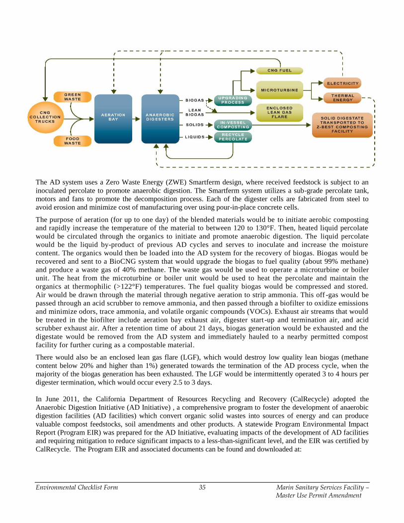
Environmental Checklist Form 35 Marin Sanitary Services Facility – Master Use Permit Amendment
The AD system uses a Zero Waste Energy (ZWE) Smartferm design, where received feedstock is subject to an
inoculated percolate to promote anaerobic digestion. The Smartferm system utilizes a sub-grade percolate tank,
motors and fans to promote the decomposition process. Each of the digester cells are fabricated from steel to
avoid erosion and minimize cost of manufacturing over using pour-in-place concrete cells.
The purpose of aeration (for up to one day) of the blended materials would be to initiate aerobic composting
and rapidly increase the temperature of the material to between 120 to 130°F. Then, heated liquid percolate
would be circulated through the organics to initiate and promote anaerobic digestion. The liquid percolate
would be the liquid by-product of previous AD cycles and serves to inoculate and increase the moisture
content. The organics would then be loaded into the AD system for the recovery of biogas. Biogas would be
recovered and sent to a BioCNG system that would upgrade the biogas to fuel quality (about 99% methane)
and produce a waste gas of 40% methane. The waste gas would be used to operate a microturbine or boiler
unit. The heat from the microturbine or boiler unit would be used to heat the percolate and maintain the
organics at thermophilic (>122°F) temperatures. The fuel quality biogas would be compressed and stored.
Air would be drawn through the material through negative aeration to strip ammonia. This off -gas would be
passed through an acid scrubber to remove ammonia, and then passed through a biofilter to oxidize emissions
and minimize odors, trace ammonia, and volatile organic compounds (VOCs). Exhaust air streams that would
be treated in the biofilter include aeration bay exhaust air, digester start -up and termination air, and acid
scrubber exhaust air. After a retention time of about 21 days, biogas generation would be exhausted and the
digestate would be removed from the AD system and immediately hauled to a nearby permitted compost
facility for further curing as a compostable material.
There would also be an enclosed lean gas flare (LGF), which would destroy low quality lean biogas (methane
content below 20% and higher than 1%) generated towards the termination of the AD process cycle, when the
majority of the biogas generation has been exhausted. The LGF would be intermittently operated 3 to 4 hours per
digester termination, which would occur every 2.5 to 3 days.
In June 2011, the California Department of Resources Recycling and Recovery (CalRecycle) adopted the
Anaerobic Digestion Initiative (AD Initiative) , a comprehensive program to foster the development of anaerobic
digestion facilities (AD facilities) which convert organic solid wastes into sources of energy and can produce
valuable compost feedstocks, soil amendments and other products. A statewide Program Environmental Impact
Report (Program EIR) was prepared for the AD Initiative, evaluating impacts of the development of AD facilities
and requiring mitigation to reduce significant impacts to a less-than-significant level, and the EIR was certified by
CalRecycle. The Program EIR and associated documents can be found and downloaded at:
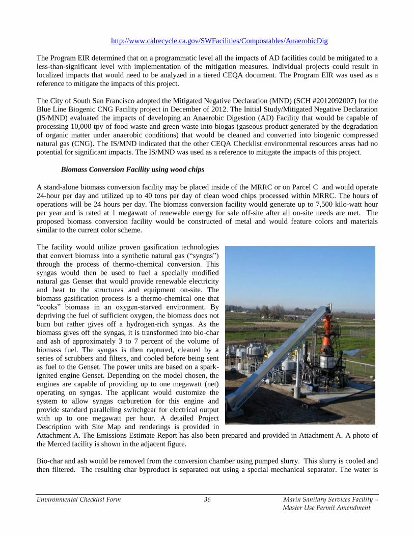
Environmental Checklist Form 36 Marin Sanitary Services Facility – Master Use Permit Amendment
http://www.calrecycle.ca.gov/SWFacilities/Compostables/AnaerobicDig
The Program EIR determined that on a programmatic level all the impacts of AD facilities could be mitigated to a
less-than-significant level with implementation of the mitigation measures. Individual projects could result in
localized impacts that would need to be analyzed in a tiered CEQA document. The Program EIR was used as a
reference to mitigate the impacts of this project.
The City of South San Francisco adopted the Mitigated Negative Declaration (MND) (SCH #2012092007) for the
Blue Line Biogenic CNG Facility project in December of 2012. The Initial Study/Mitigated Negative Declaration
(IS/MND) evaluated the impacts of developing an Anaerobic Digestion (AD) Facility that would be capable of
processing 10,000 tpy of food waste and green waste into biogas (gaseous product generated by the degradation
of organic matter under anaerobic conditions) that would be cleaned and converted into biogenic compressed
natural gas (CNG). The IS/MND indicated that the other CEQA Checklist environmental resources areas had no
potential for significant impacts. The IS/MND was used as a reference to mitigate the impacts of this project.
Biomass Conversion Facility using wood chips
A stand-alone biomass conversion facility may be placed inside of the MRRC or on Parcel C and would operate
24-hour per day and utilized up to 40 tons per day of clean wood chips processed within MRRC. The hours of
operations will be 24 hours per day. The biomass conversion facility would generate up to 7,500 kilo-watt hour
per year and is rated at 1 megawatt of renewable energy for sale off-site after all on-site needs are met. The
proposed biomass conversion facility would be constructed of metal and would feature colors and materials
similar to the current color scheme.
The facility would utilize proven gasification technologies
that convert biomass into a synthetic natural gas (“syngas”)
through the process of thermo-chemical conversion. This
syngas would then be used to fuel a specially modified
natural gas Genset that would provide renewable electricity
and heat to the structures and equipment on-site. The
biomass gasification process is a thermo-chemical one that
“cooks” biomass in an oxygen-starved environment. By
depriving the fuel of sufficient oxygen, the biomass does not
burn but rather gives off a hydrogen-rich syngas. As the
biomass gives off the syngas, it is transformed into bio-char
and ash of approximately 3 to 7 percent of the volume of
biomass fuel. The syngas is then captured, cleaned by a
series of scrubbers and filters, and cooled before being sent
as fuel to the Genset. The power units are based on a spark-
ignited engine Genset. Depending on the model chosen, the
engines are capable of providing up to one megawatt (net)
operating on syngas. The applicant would customize the
system to allow syngas carburetion for this engine and
provide standard paralleling switchgear for electrical output
with up to one megawatt per hour. A detailed Project
Description with Site Map and renderings is provided in
Attachment A. The Emissions Estimate Report has also been prepared and provided in Attachment A. A photo of
the Merced facility is shown in the adjacent figure.
Bio-char and ash would be removed from the conversion chamber using pumped slurry. This slurry is cooled and
then filtered. The resulting char byproduct is separated out using a special mechanical separator. The water is
Environmental Checklist Form 37 Marin Sanitary Services Facility – Master Use Permit Amendment
again filtered, cooled and recirculated. Biochar is used as a soil amendment, sequestering carbon in the soil for up
to 1,000 years.
This type of project is defined as a “biomass conversion facility” in Public Resources Code 40106 (a) with the
passage of SB 498 (Lara, 2014) which means biomass conversion is the production of heat, fuels, or electricity by
non-combustion thermal conversion technologies, such as gasification, using specific biomass feedstocks.
Biomass conversion of these specific feedstocks allows the facility to be California renewable power eligible and
count towards 100% landfill diversion. Biomass conversion facilities are not required to obtain a solid waste
facility permit from the local health department or the State. However, any solid waste facility, such as MRRC,
that sends wood chips to a biomass conversion facility must report the amount of tons to the State. The solid
waste facilities may be inspected by the LEA to ensure that reporting occurs. The biomass conversion facility
operator shall file an annual report to the state on where the wood chips are received from. Operating biomass
conversion systems using gasification technologies have experience qualifying electricity as renewable power by
the California Energy Commission.
Transmission lines are proposed to connect to the AD Facility and the biomass conversion facility. A feed-in tariff
is available for selling excess electricity back to utility during off-peak periods. As such, the project includes
construction of transmission lines.
Permits, Design and Approvals
The summary of existing operations, proposed operations, including ancillary activities, overall capacities and
materials processing, and regulatory oversight is summarized below in Table 1.
Table 1: Overview of Operations and State Permit Status
Processing Facilities Activity Permit
Marin Sanitary Service
Transfer Station
(MSSTS)
Solid waste transfer and
food waste processing with
the potential addition of the
anaerobic digestion facility
for food waste and green
waste on Parcel A or Parcel
C.
Solid Waste Facility Permit Revision permit
boundary may increase from 8.5 acres to 9.0
acres. Bay Area Air Quality Management
District – Authority to Construct and Permit to
Operate
Marin Resource
Recovery Center
(MRRC)
Commercial and
construction and demolition
processing.
Solid Waste Facility Permit Revision permit
boundary may increase from 8.5 acres to 9.0
acres.. Bay Area Air Quality Management
District – Authority to Construct and Permit to
Operate.
Marin Recycling
Center
Processes residential and
commercial recyclables and
drop-off and buy-back
located on Parcel A.
California Department of Conservation
certified Buy-Back Center. Title 14 Recycling
Center exempt from state permit with a
residual rate of under 10%.
Marin Household
Hazardous Waste
Facility
Collects household
hazardous waste universal
wastes, and electronic
wastes located on Parcel A.
Permanent Household Hazardous Waste
Collection Facility (PHHWCF) permitted by
California Department of Toxic Substances
Control and regulated by the County Certified
Unified Program Agency (CUPA).
American Soils
Products (aka, A&S
Landscape Materials)
Stores fines, composts,
mulches, and landscape
products located on Parcel
Excluded from Title 14.
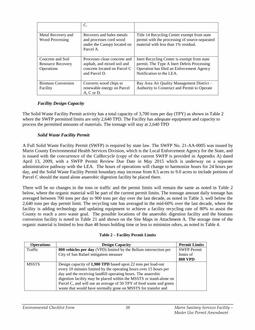
Environmental Checklist Form 38 Marin Sanitary Services Facility – Master Use Permit Amendment
C.
Metal Recovery and
Wood Processing
Recovers and bales metals
and processes cord wood
under the Canopy located on
Parcel A.
Title 14 Recycling Center exempt from state
permit with the processing of source-separated
material with less than 1% residual.
Concrete and Soil
Resource Recovery
Operations
Processes clean concrete and
asphalt, and mixed soil and
concrete located on Parcel C
and Parcel D.
Inert Recycling Center is exempt from state
permit. The Type A Inert Debris Processing
Operation has filed an Enforcement Agency
Notification to the LEA.
Biomass Conversion
Facility
Converts wood chips to
renewable energy on Parcel
A, C or D.
Bay Area Air Quality Management District –
Authority to Construct and Permit to Operate
Facility Design Capacity
The Solid Waste Facility Permit activity has a total capacity of 3,700 tons per day (TPY) as shown in Table 2
where the SWFP permitted limits are only 2,640 TPD. The Facility has adequate equipment and capacity to
process the permitted amounts of materials. The tonnage will stay at 2,640 TPD
Solid Waste Facility Permit
A Full Solid Waste Facility Permit (SWFP) is required by state law. The SWFP No. 21-AA-0005 was issued by
Marin County Environmental Health Services Division, which is the Local Enforcement Agency for the State, and
is issued with the concurrence of the CalRecycle (copy of the current SWFP is provided in Appendix A) dated
April 13, 2009, with a SWFP Permit Review Due Date in May 2015 which is underway on a separate
administrative pathway with the LEA. The hours of operations will change to harmonize hours for 24 hours per
day, and the Solid Waste Facility Permit boundary may increase from 8.5 acres to 9.0 acres to include portions of
Parcel C should the stand alone anaerobic digestion facility be placed there.
There will be no changes in the tons or traffic and the permit limits will remain the same as noted in Table 2
below, where the organic material will be part of the current permit limits. The tonnage amount daily tonnage has
averaged between 700 tons per day to 900 tons per day over the last decade, as noted in Table 3, well below the
2,640 tons per day permit limit. The recycling rate has averaged in the mid-60% over the last decade, where the
facility is adding technology and updating equipment to achieve a facility recycling rate of 80% to assist the
County to reach a zero waste goal. The possible locations of the anaerobic digestion facility and the biomass
conversion facility is noted in Table 21 and shown on the Site Maps in Attachment A. The storage time of the
organic material is limited to less than 48 hours holding time or less to minimize odors, as noted in Table 4.
Table 2 – Facility Permit Limits
Operations Design Capacity Permit Limits
Traffic 800 vehicles per day (VPD) limited by the Bellam intersection per
City of San Rafael mitigation measure
SWFP Permit
limits of
800 VPD
MSSTS Design capacity of 1,980 TPD based upon 22 tons per load-out
every 10 minutes limited by the operating hours over 15 hours per
day and the receiving landfill operating hours. The anaerobic
digestion facility may be placed within the MSSTS or stand-alone on
Parcel C, and will use an average of 50 TPY of food waste and green
waste that would have normally gone on MSSTS for transfer and
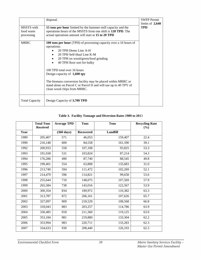
Environmental Checklist Form 39 Marin Sanitary Services Facility – Master Use Permit Amendment
disposal.
SWFP Permit
limits of 2,640
TPD MSSTS with
food waste
processing
15 tons per hour limited by the hammer-mill capacity and the
operations hours of the MSSTS from one shift is 120 TPD. The
actual operations amount will start at 15 to 20 TPD
MRRC 100 tons per hour (TPH) of processing capacity over a 16 hours of
operations:
20 TPH Demo Line A-H
20 TPH Self-Haul Line K-M
20 TPH on wood/green/food grinding
40 TPH floor sort for bulky
100 TPD total over 16 hours
Design capacity of 1,600 tpy
The biomass conversion facility may be placed within MRRC or
stand alone on Parcel C or Parcel D and will use up to 40 TPY of
clean wood chips from MRRC.
Total Capacity
Design Capacity of 3,700 TPD
Table 3. Facility Tonnage and Diversion Rates 1989 to 2013
Total Tons
Received
Average TPD Tons Tons Recycling Rate
(%)
Year (360 days) Recovered Landfill
1989 205,407 571 46,053 159,407 22.4
1990 216,148 600 84,558 161,590 39.1
1992 200,933 558 107,108 93,825 53.3
1993 191,038 531 103,824 87,214 54.3
1994 176,286 490 87,740 88,545 49.8
1995 199,401 554 63,808 135,683 31.0
1996 213,740 594 111,472 102,269 52.1
1997 214,479 596 114,821 99,658 53.6
1998 255,644 710 148,075 107,569 57.9
1999 265,584 738 143,016 122,567 53.9
2000 300,354 834 189,972 110,382 63.3
2001 313,787 872 206,161 107,626 65.7
2002 327,097 909 218,529 108,568 66.8
2003 318,043 883 203,257 114,786 63.9
2004 330,485 918 211,360 119,125 63.9
2005 353,184 981 219,880 133,304 62.2
2006 353,994 983 220,711 133,283 62.3
2007 334,633 930 208,440 126,193 62.3
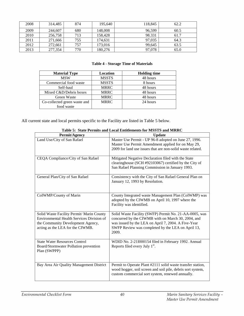
Environmental Checklist Form 40 Marin Sanitary Services Facility – Master Use Permit Amendment
2008 314,485 874 195,640 118,845 62.2
2009 244,607 680 148,008 96,599 60.5
2010 256,758 713 158,428 98.331 61.7
2011 271,666 755 174,631 97,035 64.3
2012 272,661 757 173,016 99,645 63.5
2013 277,354 770 180,276 97,078 65.0
Table 4 - Storage Time of Materials
Material Type Location Holding time
MSW MSSTS 48 hours
Commercial food waste MSSTS 8 hours
Self-haul MRRC 48 hours
Mixed C&D/Debris boxes MRRC 48 hours
Green Waste MRRC 48 hours
Co-collected green waste and
food waste
MRRC 24 hours
All current state and local permits specific to the Facility are listed in Table 5 below.
Table 5: State Permits and Local Entitlements for MSSTS and MRRC
Permit/Agency Update
Land Use/City of San Rafael Master Use Permit - UP 96-8 adopted on June 27, 1996.
Master Use Permit Amendment applied for on May 29,
2009 for land use issues that are non-solid waste related.
CEQA Compliance/City of San Rafael Mitigated Negative Declaration filed with the State
clearinghouse (SCH #92103067) certified by the City of
San Rafael Planning Commission in January 1993.
General Plan/City of San Rafael Consistency with the City of San Rafael General Plan on
January 12, 1993 by Resolution.
CoIWMP/County of Marin County Integrated waste Management Plan (CoIWMP) was
adopted by the CIWMB on April 10, 1997 where the
Facility was identified.
Solid Waste Facility Permit/ Marin County
Environmental Health Services Division of
the Community Development Agency,
acting as the LEA for the CIWMB.
Solid Waste Facility (SWFP) Permit No. 21-AA-0005, was
concurred by the CIWMB with on March 30, 2004, and
was issued by the LEA on April 7, 2004. A Five-Year
SWFP Review was completed by the LEA on April 13,
2009.
State Water Resources Control
Board/Stormwater Pollution prevention
Plan (SWPPP)
WDID No. 2-21I000154 filed in February 1992. Annual
Reports filed every July 1st.
Bay Area Air Quality Management District
Permit to Operate Plant #2111 solid waste transfer station,
wood hogger, soil screen and soil pile, debris sort system,
custom commercial sort system, renewed annually.
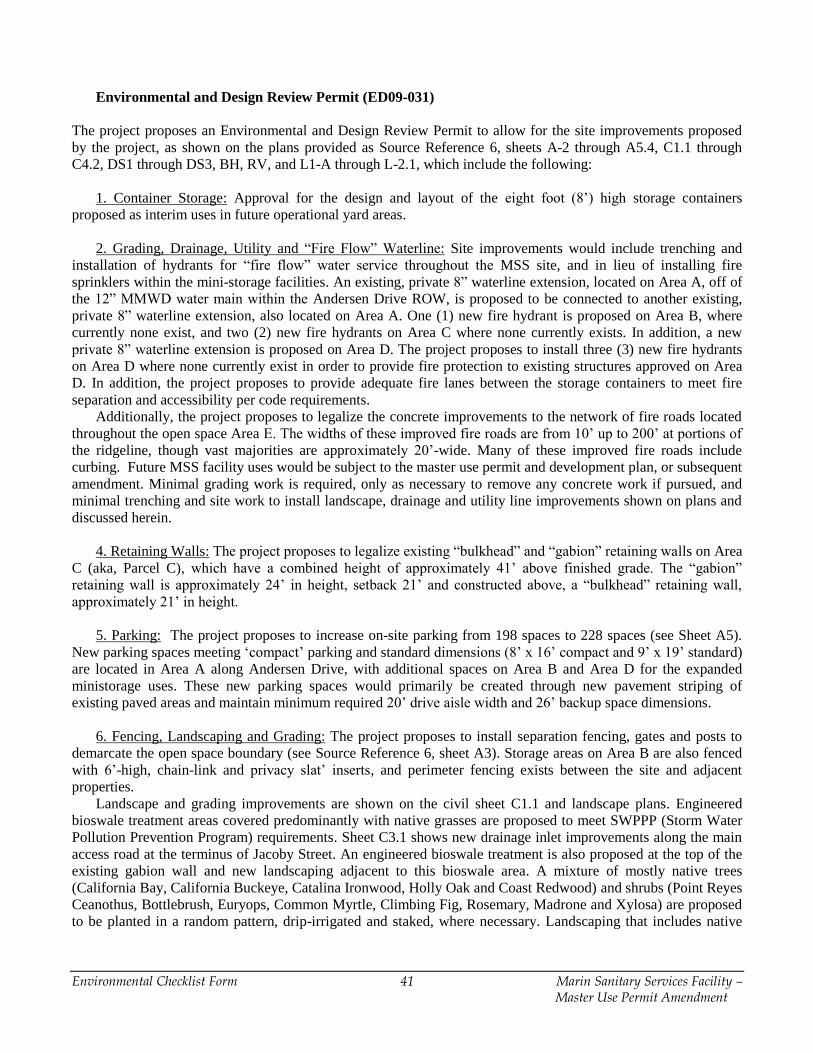
Environmental Checklist Form 41 Marin Sanitary Services Facility – Master Use Permit Amendment
Environmental and Design Review Permit (ED09-031)
The project proposes an Environmental and Design Review Permit to allow for the site improvements proposed
by the project, as shown on the plans provided as Source Reference 6, sheets A-2 through A5.4, C1.1 through
C4.2, DS1 through DS3, BH, RV, and L1-A through L-2.1, which include the following:
1. Container Storage: Approval for the design and layout of the eight foot (8’) high storage containers
proposed as interim uses in future operational yard areas.
2. Grading, Drainage, Utility and “Fire Flow” Waterline: Site improvements would include trenching and
installation of hydrants for “fire flow” water service throughout the MSS site, and in lieu of installing fire
sprinklers within the mini-storage facilities. An existing, private 8” waterline extension, located on Area A, off of
the 12” MMWD water main within the Andersen Drive ROW, is proposed to be connected to another existing,
private 8” waterline extension, also located on Area A. One (1) new fire hydrant is proposed on Area B, where
currently none exist, and two (2) new fire hydrants on Area C where none currently exists. In addition, a new
private 8” waterline extension is proposed on Area D. The project proposes to install three (3) new fire hydrants
on Area D where none currently exist in order to provide fire protection to existing structures approved on Area
D. In addition, the project proposes to provide adequate fire lanes between the storage containers to meet fire
separation and accessibility per code requirements.
Additionally, the project proposes to legalize the concrete improvements to the network of fire roads located
throughout the open space Area E. The widths of these improved fire roads are from 10’ up to 200’ at portions of
the ridgeline, though vast majorities are approximately 20’-wide. Many of these improved fire roads include
curbing. Future MSS facility uses would be subject to the master use permit and development plan, or subsequent
amendment. Minimal grading work is required, only as necessary to remove any concrete work if pursued, and
minimal trenching and site work to install landscape, drainage and utility line improvements shown on plans and
discussed herein.
4. Retaining Walls: The project proposes to legalize existing “bulkhead” and “gabion” retaining walls on Area
C (aka, Parcel C), which have a combined height of approximately 41’ above finished grade. The “gabion”
retaining wall is approximately 24’ in height, setback 21’ and constructed above, a “bulkhead” retaining wall,
approximately 21’ in height.
5. Parking: The project proposes to increase on-site parking from 198 spaces to 228 spaces (see Sheet A5).
New parking spaces meeting ‘compact’ parking and standard dimensions (8’ x 16’ compact and 9’ x 19’ standard)
are located in Area A along Andersen Drive, with additional spaces on Area B and Area D for the expanded
ministorage uses. These new parking spaces would primarily be created through new pavement striping of
existing paved areas and maintain minimum required 20’ drive aisle width and 26’ backup space dimensions.
6. Fencing, Landscaping and Grading: The project proposes to install separation fencing, gates and posts to
demarcate the open space boundary (see Source Reference 6, sheet A3). Storage areas on Area B are also fenced
with 6’-high, chain-link and privacy slat’ inserts, and perimeter fencing exists between the site and adjacent
properties.
Landscape and grading improvements are shown on the civil sheet C1.1 and landscape plans. Engineered
bioswale treatment areas covered predominantly with native grasses are proposed to meet SWPPP (Storm Water
Pollution Prevention Program) requirements. Sheet C3.1 shows new drainage inlet improvements along the main
access road at the terminus of Jacoby Street. An engineered bioswale treatment is also proposed at the top of the
existing gabion wall and new landscaping adjacent to this bioswale area. A mixture of mostly native trees
(California Bay, California Buckeye, Catalina Ironwood, Holly Oak and Coast Redwood) and shrubs (Point Reyes
Ceanothus, Bottlebrush, Euryops, Common Myrtle, Climbing Fig, Rosemary, Madrone and Xylosa) are proposed
to be planted in a random pattern, drip-irrigated and staked, where necessary. Landscaping that includes native
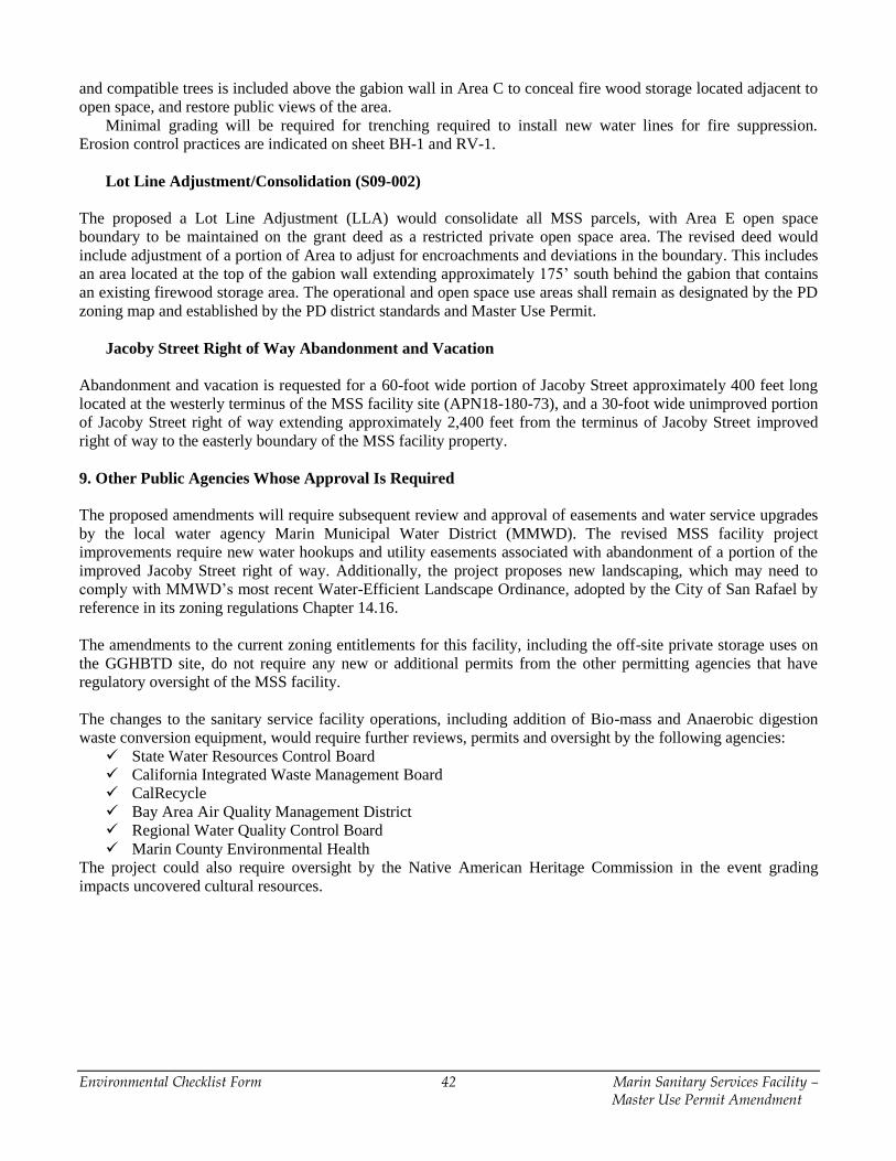
Environmental Checklist Form 42 Marin Sanitary Services Facility – Master Use Permit Amendment
and compatible trees is included above the gabion wall in Area C to conceal fire wood storage located adjacent to
open space, and restore public views of the area.
Minimal grading will be required for trenching required to install new water lines for fire suppression.
Erosion control practices are indicated on sheet BH-1 and RV-1.
Lot Line Adjustment/Consolidation (S09-002)
The proposed a Lot Line Adjustment (LLA) would consolidate all MSS parcels, with Area E open space
boundary to be maintained on the grant deed as a restricted private open space area. The revised deed would
include adjustment of a portion of Area to adjust for encroachments and deviations in the boundary. This includes
an area located at the top of the gabion wall extending approximately 175’ south behind the gabion that contains
an existing firewood storage area. The operational and open space use areas shall remain as designated by the PD
zoning map and established by the PD district standards and Master Use Permit.
Jacoby Street Right of Way Abandonment and Vacation
Abandonment and vacation is requested for a 60-foot wide portion of Jacoby Street approximately 400 feet long
located at the westerly terminus of the MSS facility site (APN18-180-73), and a 30-foot wide unimproved portion
of Jacoby Street right of way extending approximately 2,400 feet from the terminus of Jacoby Street improved
right of way to the easterly boundary of the MSS facility property.
9. Other Public Agencies Whose Approval Is Required
The proposed amendments will require subsequent review and approval of easements and water service upgrades
by the local water agency Marin Municipal Water District (MMWD). The revised MSS facility project
improvements require new water hookups and utility easements associated with abandonment of a portion of the
improved Jacoby Street right of way. Additionally, the project proposes new landscaping, which may need to
comply with MMWD’s most recent Water-Efficient Landscape Ordinance, adopted by the City of San Rafael by
reference in its zoning regulations Chapter 14.16.
The amendments to the current zoning entitlements for this facility, including the off-site private storage uses on
the GGHBTD site, do not require any new or additional permits from the other permitting agencies that have
regulatory oversight of the MSS facility.
The changes to the sanitary service facility operations, including addition of Bio-mass and Anaerobic digestion
waste conversion equipment, would require further reviews, permits and oversight by the following agencies:
State Water Resources Control Board
California Integrated Waste Management Board
CalRecycle
Bay Area Air Quality Management District
Regional Water Quality Control Board
Marin County Environmental Health
The project could also require oversight by the Native American Heritage Commission in the event grading
impacts uncovered cultural resources.
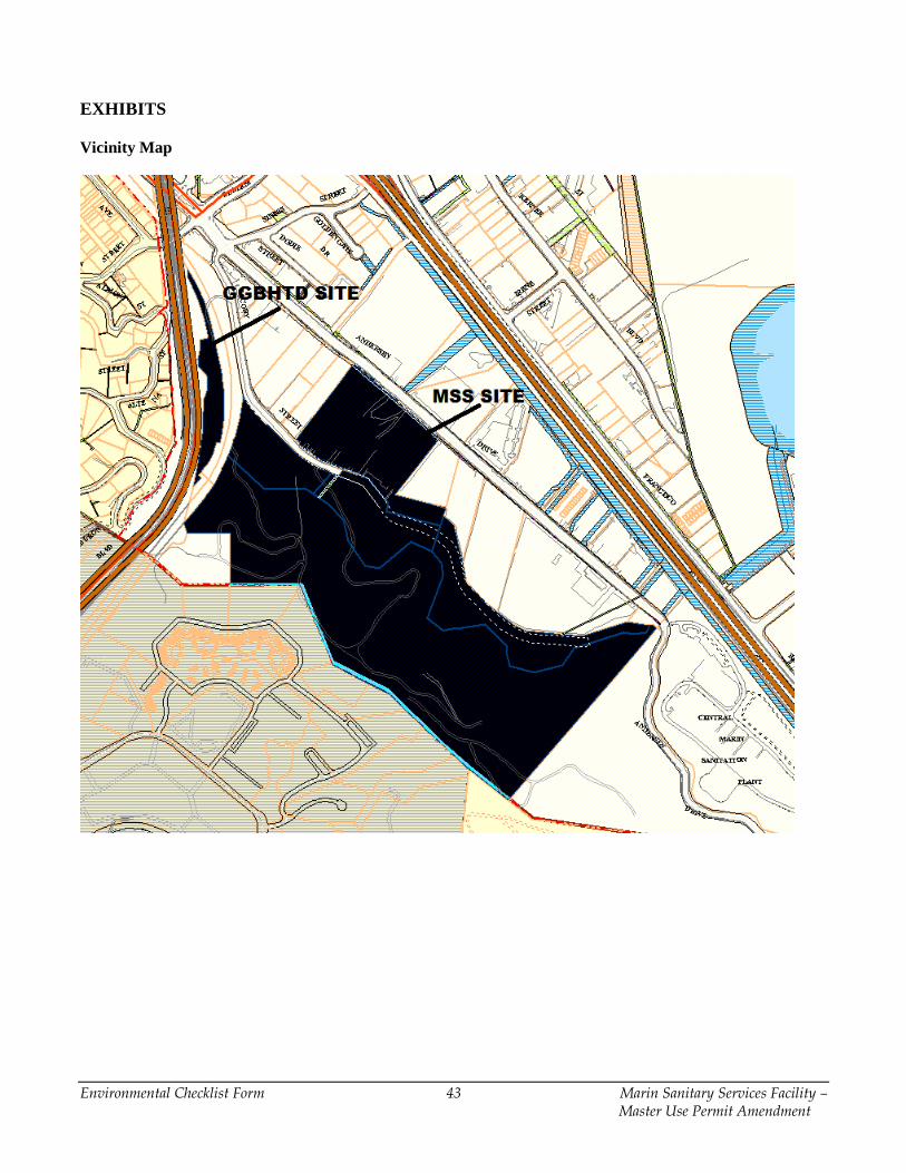
Environmental Checklist Form 43 Marin Sanitary Services Facility – Master Use Permit Amendment
EXHIBITS
Vicinity Map
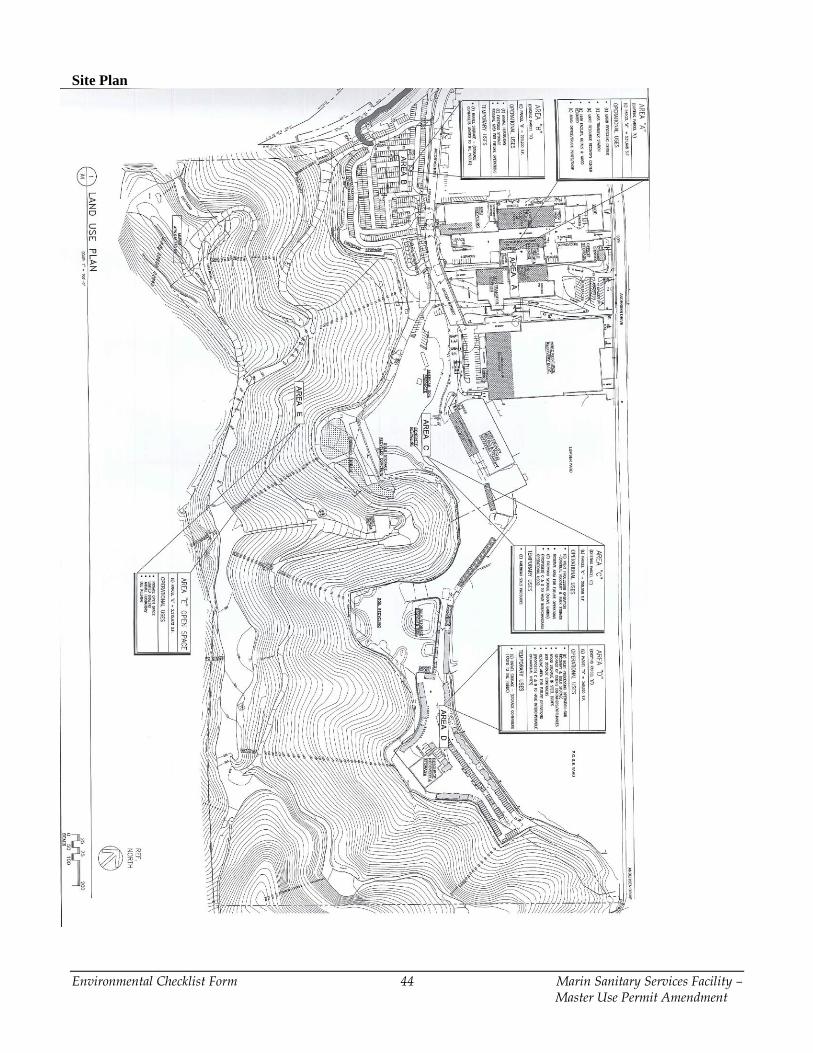
Environmental Checklist Form 44 Marin Sanitary Services Facility – Master Use Permit Amendment
Site Plan
Environmental Checklist Form 45 Marin Sanitary Services Facility – Master Use Permit Amendment
ENVIRONMENTAL FACTORS POTENTIALLY AFFECTED
The environmental factors checked below would be potentially affected by this project, involving at least one
impact that is a "Potentially Significant Impact" as indicated by the checklist on the following pages.
Aesthetics Agriculture Resources Air Quality
Biological Resources Cultural Resources Geology /Soils
Greenhouse Gas Emissions Hazards & Hazardous
Materials
Hydrology / Water Quality
Land Use / Planning Mineral Resources Noise
Population / Housing Public Services Recreation
Transportation / Traffic Utilities / Service Systems Mandatory Finding of
Significance
DETERMINATION
On the basis of this initial evaluation:
I find that the proposed project COULD NOT have a significant effect on the environment and
a NEGATIVE DECLARATION will be prepared.
I find that although the proposed project could have a significant effect on the environment,
there will not be a significant effect in this case because revisions in the project have been
made by or agreed to by the project proponent. A MITIGATED NEGATIVE
DECLARATION will be prepared.
I find that the proposed project MAY have a significant effect on the environment, and an
ENVIRONMENTAL IMPACT REPORT is required.
I find that the proposed project MAY have a “potentially significant impact” or “potentially
significant unless mitigated" impact on the environment, but at lest one effect 1) has been
adequately analyzed in an earlier document pursuant to applicable legal standards, and 2) has
been addressed by mitigation measures based on the earlier analysis as described on attached
sheets. An ENVIRONMENTAL IMPACT REPORT is required, but it must analyze only the
effects that remain to be addressed.
I find that although the proposed project could have a significant effect on the environment,
because all potentially significant effects (a) have been analyzed adequately in an EARLIER
EIR or NEGATIVE DECLARATION pursuant to applicable legal standards, and (b) have
been avoided or mitigated pursuant to that earlier EIR or NEGATIVE DECLARATION,
including revisions or mitigation measures that are imposed upon the proposed project, nothing
further is required.
Kraig Tambornini, Senior Planner
____________________________________ May 11, 2015__________
Signature Date
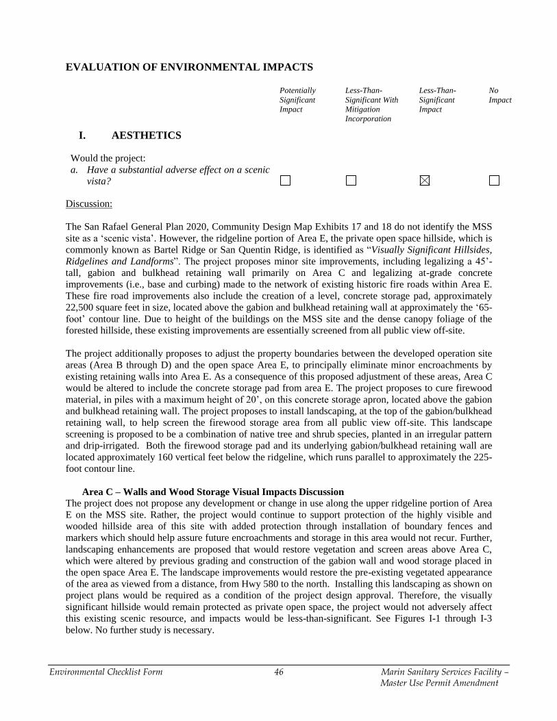
Environmental Checklist Form 46 Marin Sanitary Services Facility – Master Use Permit Amendment
EVALUATION OF ENVIRONMENTAL IMPACTS
Potentially
Significant
Impact
Less-Than-
Significant With
Mitigation
Incorporation
Less-Than-
Significant
Impact
No
Impact
I. AESTHETICS
Would the project:
a. Have a substantial adverse effect on a scenic
vista?
Discussion:
The San Rafael General Plan 2020, Community Design Map Exhibits 17 and 18 do not identify the MSS
site as a ‘scenic vista’. However, the ridgeline portion of Area E, the private open space hillside, which is
commonly known as Bartel Ridge or San Quentin Ridge, is identified as “Visually Significant Hillsides,
Ridgelines and Landforms”. The project proposes minor site improvements, including legalizing a 45’-
tall, gabion and bulkhead retaining wall primarily on Area C and legalizing at-grade concrete
improvements (i.e., base and curbing) made to the network of existing historic fire roads within Area E.
These fire road improvements also include the creation of a level, concrete storage pad, approximately
22,500 square feet in size, located above the gabion and bulkhead retaining wall at approximately the ‘65-
foot’ contour line. Due to height of the buildings on the MSS site and the dense canopy foliage of the
forested hillside, these existing improvements are essentially screened from all public view off-site.
The project additionally proposes to adjust the property boundaries between the developed operation site
areas (Area B through D) and the open space Area E, to principally eliminate minor encroachments by
existing retaining walls into Area E. As a consequence of this proposed adjustment of these areas, Area C
would be altered to include the concrete storage pad from area E. The project proposes to cure firewood
material, in piles with a maximum height of 20’, on this concrete storage apron, located above the gabion
and bulkhead retaining wall. The project proposes to install landscaping, at the top of the gabion/bulkhead
retaining wall, to help screen the firewood storage area from all public view off-site. This landscape
screening is proposed to be a combination of native tree and shrub species, planted in an irregular pattern
and drip-irrigated. Both the firewood storage pad and its underlying gabion/bulkhead retaining wall are
located approximately 160 vertical feet below the ridgeline, which runs parallel to approximately the 225-
foot contour line.
Area C – Walls and Wood Storage Visual Impacts Discussion
The project does not propose any development or change in use along the upper ridgeline portion of Area
E on the MSS site. Rather, the project would continue to support protection of the highly visible and
wooded hillside area of this site with added protection through installation of boundary fences and
markers which should help assure future encroachments and storage in this area would not recur. Further,
landscaping enhancements are proposed that would restore vegetation and screen areas above Area C,
which were altered by previous grading and construction of the gabion wall and wood storage placed in
the open space Area E. The landscape improvements would restore the pre-existing vegetated appearance
of the area as viewed from a distance, from Hwy 580 to the north. Installing this landscaping as shown on
project plans would be required as a condition of the project design approval. Therefore, the visually
significant hillside would remain protected as private open space, the project would not adversely affect
this existing scenic resource, and impacts would be less-than-significant. See Figures I-1 through I-3
below. No further study is necessary.
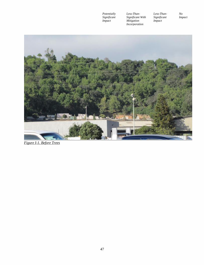
Potentially
Significant
Impact
Less-Than-
Significant With
Mitigation
Incorporation
Less-Than-
Significant
Impact
No
Impact
47
Figure I-1. Before Trees
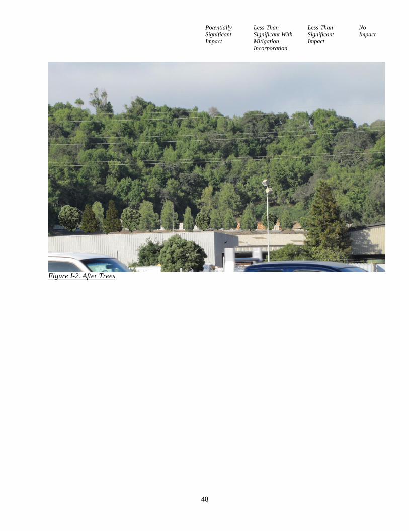
Potentially
Significant
Impact
Less-Than-
Significant With
Mitigation
Incorporation
Less-Than-
Significant
Impact
No
Impact
48
Figure I-2. After Trees
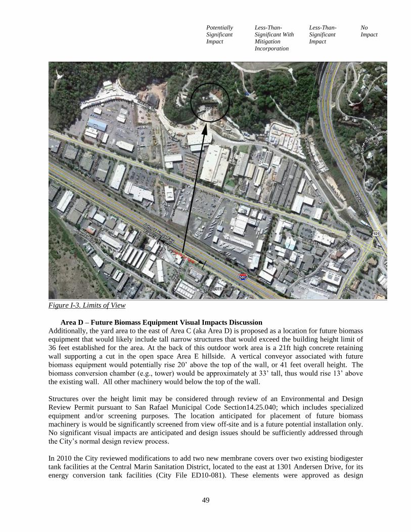
Potentially
Significant
Impact
Less-Than-
Significant With
Mitigation
Incorporation
Less-Than-
Significant
Impact
No
Impact
49
Figure I-3. Limits of View
Area D – Future Biomass Equipment Visual Impacts Discussion
Additionally, the yard area to the east of Area C (aka Area D) is proposed as a location for future biomass
equipment that would likely include tall narrow structures that would exceed the building height limit of
36 feet established for the area. At the back of this outdoor work area is a 21ft high concrete retaining
wall supporting a cut in the open space Area E hillside. A vertical conveyor associated with future
biomass equipment would potentially rise 20’ above the top of the wall, or 41 feet overall height. The
biomass conversion chamber (e.g., tower) would be approximately at 33’ tall, thus would rise 13’ above
the existing wall. All other machinery would below the top of the wall.
Structures over the height limit may be considered through review of an Environmental and Design
Review Permit pursuant to San Rafael Municipal Code Section14.25.040; which includes specialized
equipment and/or screening purposes. The location anticipated for placement of future biomass
machinery is would be significantly screened from view off-site and is a future potential installation only.
No significant visual impacts are anticipated and design issues should be sufficiently addressed through
the City’s normal design review process.
In 2010 the City reviewed modifications to add two new membrane covers over two existing biodigester
tank facilities at the Central Marin Sanitation District, located to the east at 1301 Andersen Drive, for its
energy conversion tank facilities (City File ED10-081). These elements were approved as design
Potentially
Significant
Impact
Less-Than-
Significant With
Mitigation
Incorporation
Less-Than-
Significant
Impact
No
Impact
50
modifications that would extend above the base district building height limits. They consist of floating
digester covers that increased the digester height by about 20 feet. The digester tanks are approximately
48 feet high and the site is similar in its location and use to MSS property.
(Sources: 1, 6)
b. Substantially damage scenic resources,
including, but not limited to, trees, rock
outcroppings, and historic buildings within a
state scenic highway?
Discussion:
Refer to discussion (a) above. Interstate 580 (I-580), located approximately 400’ northeast of the MSS
site, is an officially-designated “State Scenic Highway” by Caltrans (California Department of
Transportation). It is a heavily-travelled, 80-mile east–west Interstate Highway; a spur route of Interstate
80, connecting the San Francisco Bay Area to Interstate 5 and the Central Valley with U.S. Highway 101
and the North Bay. This segment of I-580 was previously constructed as part of the California Highway
69 route prior to its inclusion in the Interstate Highway system. Area E, the forested private opens space
on the MSS site, is visible from I-580. The project proposes to legalize a material storage pad, located
above the gabion and bulkhead retaining wall, in which the proposed, 20’-high, piles of firewood would
be partially visible from I-580. The proposed firewood storage area would not significantly damage a
scenic resource given that the project also proposes to install landscaping, at the top of the
gabion/bulkhead retaining wall, to help screen the firewood piles from public view off-site.
There are no remaining historic buildings or any visible rock outcroppings within the MSS site that, or
any scenic resources that would be affected. The San Rafael Historical/Architectural Survey lists a single-
family residence (the ‘Bartel House’) located within Area E on the site (aka 524 Jacoby Street) as a
locally-protected cultural resource. This ‘listed’ historic building was demolished sometime after 1977. Its
remaining foundation has been incorporated into an existing metal equipment storage shed and remains
the only structure in Area E with the exception of a small water storage tank. The dense canopy foliage of
the forested hillside essentially screens the existing metal equipment storage shed from public view off-
site. The only change as a result of the project involves increased landscaping above the gabion wall,
which would blend in with the natural setting and provide screening of an existing work area. Therefore,
impacts on scenic resources or historic buildings would be less-than-significant. No further study is
required.
(Sources: 1, 6)
c. Substantially degrade the existing visual
character or quality of the site and its
surroundings?
Discussion:
Refer to discussion (a) and (b) above. The project proposes to legalize a material storage pad, located
above the gabion and bulkhead retaining wall, in order to store and cure 20’-high piles of firewood. The
proposed firewood storage area would not substantially degrade the existing visual character of the MSS
site given that the project also proposes to install landscaping, between the top of the gabion/bulkhead
Potentially
Significant
Impact
Less-Than-
Significant With
Mitigation
Incorporation
Less-Than-
Significant
Impact
No
Impact
51
retaining wall and the firewood piles, to help screen the firewood piles from public view off-site,
particularly visibility along westbound I-580. The gabion and bulkhead retaining wall itself cannot be
seen from off-site due to the height of existing buildings developed along southern elevation of Andersen
Drive. Impacts on the visual character or quality of the site and its surroundings would be less-than-
significant. No further study is necessary.
(Sources: 1, 6)
d. Create a new source of substantial light or
glare which would adversely affect day or
nighttime views in the area?
Discussion:
MSS currently provides, and will continue to provide, municipal solid waste collection and recycling
services on site. It operates 24-hours a day, seven days a week; though, it is open to the public on a
limited basis, from 8 a.m. to 4 p.m. daily. No additional lighting sources are proposed for the MSS site.
New parking spaces, located both immediately south of the Marin Resource Recovery Center (MRRC)
building in Area A and east of the relocated storage container facility on Area C, are not proposed to be
illuminated since the hours of operation in which MSS is open to the public are limited to daytime only.
The project would not create any new sources of light or glare. No impacts would result. No further study
is necessary.
(Sources: 6, 7)
II. AGRICULTURE AND FOREST RESOURCES
Would the project: {In determining whether
impacts to agricultural resources are significant
environmental effects, lead agencies may refer to
the California Agricultural Land Evaluation and
Site Assessment Model (1997) prepared by the
California Dept. of Conservation as an optional
model to use in assessing impacts on agriculture
and farmland.} In determining whether impacts
to a forest resources, including timberland, are
significant environmental effects, lead agencies
may refer to information compiled by the
California Department of Forestry and Fire
Protection regarding the state’s inventory of
forest land, including the Forest and Range
Assessment Project and the Forest Legacy
assessment Project; and forest carbon
measurement methodology provided in Forest
Protocols adopted by the California Air Resource
Board.
a. Convert Prime Farmland, Unique Farmland,
or Farmland of Statewide Importance
(Farmland), as shown on the maps prepared
Potentially
Significant
Impact
Less-Than-
Significant With
Mitigation
Incorporation
Less-Than-
Significant
Impact
No
Impact
52
pursuant to the Farmland Mapping and
Monitoring Program of the California
Resources Agency, to non-agricultural use?
Discussion:
The General Plan land use designation for the MSS site is Industrial (I) on the developed parcels (Areas A
through D) and Conservation (C) on the private open space hillside (Area E). Agricultural uses are
currently not identified as a land use category allowed in either General Plan land use designation. The
zoning classification for the MSS site is Industrial (I) for Area A and Planned Development (PD 1580) for
Areas B through E. Agricultural uses are also currently not identified an allowable land use in either
zoning districts. The City of San Rafael, including the MSS site, does not contain Prime Farmland or
other land of significant agricultural value, nor are there such lands with the City’s Sphere of Influence or
Urban Service Area. The project does not propose to convert any farmlands designated on State maps to
non-agricultural use. No impact would result. No further study is necessary.
(Sources: 1)
b. Conflict with existing zoning for agricultural
use, or a Williamson Act contract?
Discussion:
Refer to (a) discussion above. The MSS site is not zoned for agricultural use. No agricultural use current
exists on the site, with the exception of the animal husbandry facility located on Area B. Further, the
property is not subject to any Williamson Act of 1965 contracts established to preserve agricultural and
open space lands. No impact would result. No further study is necessary.
(Sources: 1)
c. Conflict with existing zoning for, or cause
rezoning of, forest land (as defined in Public
Resources Code section 12220(g)),
timberland (as defined by Public Resources
Code section 4526), or timberland zoned
Timberland Production (as defined by
Government Code section 511104(g))
Discussion:
Refer to (a) discussion above. Areas A through D are the developed portion of the MSS site, while Area E
is the undeveloped, open space forest hillside. While the project proposes to rezone the MSS site and
consolidate parcels it does not propose to modify or alter the current open space land use protections on
Area E. The entire existing, 50.87 acre, oak woodland forest on Area E would continue to be preserved by
the project as private open space. No impact would result.
(Sources: 1, 6)
d. Result in the loss of forest land or conversion
Potentially
Significant
Impact
Less-Than-
Significant With
Mitigation
Incorporation
Less-Than-
Significant
Impact
No
Impact
53
of forest land to non-forest use?
Discussion:
Refer to discussion (c) above. The project would not result in any expansion of existing MSS areas of
operations. No impact on existing forest lands, including the native hillside vegetation contained in Area
E would result.
(Sources: 1, 6)
e. Involve other changes in the existing
environment which, due to their location or
nature, could result in conversion of
Farmland, to non-agricultural use or
conversion of forest land to non-forest use?
Discussion:
Refer to (a), (c) and (d) discussion above. No farmland exists on the MSS site and no farmland exists in
the immediate vicinity of the site. The project proposes a minor adjustment of the boundary of MSS
operation site areas (Area D) and the open space Area E, that will result in the protection of an additional,
approximately 16,000 square feet (approximately 40’ in width and 400’ length) of existing oak woodland
habitat as private open space. Impacts would be less-than-significant, with a net increase in protected
woodland habitat.
(Sources: 1, 6)
III. AIR QUALITY
Would the project:
a. Conflict with or obstruct implementation of
the applicable air quality plan?
Discussion:
The project would continue an existing sanitary service facility use, including the legalization of ancillary
mini-storage uses which would be reduced in scope. A 12,500 ton per year anaerobic digestion facility
and a 1.0 mega-watt biomass conversion facility are proposed as new components as part of the existing
waste facility operations. The new facility would be within existing yard and facility areas of the site.
A self-contained anaerobic digestion facility to generate renewable power from bio-methane generated by
digesting food and green waste will likely be installed in the near future. Food waste and green waste may
be sourced from commercial, multi-family, and residential sources. The facility could supply up to 2.1
million kilo-watt power per year to meet the entire facility energy demand or up to 160,000 of diesel
gallons equivalents (dge) of renewable natural gas to fuel a fleet of approximately 16 heavy-duty vehicles.
A stand-alone biomass conversion facility may utilize up to 40 tons per day of clean wood chips
processed within MRRC. The biomass conversion facility would generate up to 7,500 kilo-watt hour per
year and is rated at 1 megawatt of renewable energy for sale off-site after all on-site needs are met.
Potentially
Significant
Impact
Less-Than-
Significant With
Mitigation
Incorporation
Less-Than-
Significant
Impact
No
Impact
54
These proposed waste facility operational activities would remain subject to County and State oversight
of waste management operations which assure the facility is operated in compliance with health and
safety regulations intended to avoid adverse impacts to air quality, odor, and water quality impacts.
Further, the project has been subject to evaluation to ensure project activities would comply with the
City’s climate change action plan.
On July 18, 2011 the City Council adopted a Greenhouse Gas Emissions Reduction Strategy. This
strategy serves as a technical appendix to the 2009 adopted Climate Change Action Plan (CCAP), i.e.,
Appendix E of the San Rafael Climate Change Action Plan (P11-009). Concurrently, General Plan
Amendment GPA11-001 was adopted to include the General Plan 2020 Sustainability Element policies.
These amendments were adopted in response to SB97 and changes to rules implemented by the regional
air district that covers San Rafael (the Bay Area Air Quality Management District (BAAQMD)), which in
2010 to update its CEQA Air Quality Guidelines for the Bay Area; requiring that projects address new
state climate change and GHG reduction requirements (consistent with AB32 goals). As an alternative to
conducting a project-by-project GHG analysis, the BAAQMD Guidelines allow the preparation and
adoption of a GHG Emissions Reduction Plan to examine emissions and reduction strategies at a
community-wide level. This is encouraged by BAAQMD as a more proactive means of achieving desired
air quality changes. The amended CCAP GHG Reduction Strategy plan was reviewed by BAAQMD, and
meets its requirements for a Qualified Greenhouse Gas Reduction Strategy.
The CCAP and accompanying strategy are intended to be updated from time to time to report out change
and process on achieving GHG reductions. This document was prepared to meet the BAAQMD
standards as a “Qualified GHG Reduction Strategy”. As a “qualified” strategy, it limits the need to
prepare a quantified GHG assessment for projects that are consistent with the San Rafael General Plan
2020. A GHG Reduction Strategy Checklist was also prepared that identifies required elements that
projects must satisfy in order be compliant with the CCAP. This document is expected to be updated
frequently as programs are completed, others added and emission data is refined. The City meets the
BAAQMD requirement, as a Qualified Greenhouse Gas Reduction Strategy, because it includes; an
emission inventory and projections required by SB375, target reductions, application of GHG reduction
measures, a checklist to require implementation of measures in a project, monitoring and updating the
GHG inventory and reduction measures every 3-5 years before 2020, requires the annual reporting on
progress of implementation of CCAP / GHG Reduction Plan programs, and regular monitoring of
community-wide GHG levels to assure that Plan objectives are being met. Compliance with the GHG
Reduction Strategy Checklist ensures compliance with the General Plan Sustainability Element and the
CCAP and ordinances adopted to implement these policies.
Amendments to the San Rafael Municipal Code have also been made, and are currently being pursued, to
provide legislative standards that implement the Sustainability Element and the CCAP (this has included
updates to adopt City water-efficient landscaping standards, parking paving, design and landscape
requirements, a ban on foam containers and plastic bags, among others). Compliance with the CCAP
assures that the Sustainability Element policies would be addressed, and that a development project would
satisfy regional air quality and GHG reduction requirements enforced by the Bay Area Air Quality
Management District (BAAQMD).
A project is also subject to an initial screening to ensure that the project that complies with the GHG
strategy would not still result in potentially significant air quality impacts. If all the screening criteria are
met by the project then the City would not need to perform a detailed air quality assessment of the project
air pollutant emissions. The screening criteria are used for non-stationary sour emissions. Stationary
source emissions (e.g., backup generators) are not included in the screening estimates provided by
BAAQMD, and for criteria pollutants must be added to the indirect mobile and area source emissions
Potentially
Significant
Impact
Less-Than-
Significant With
Mitigation
Incorporation
Less-Than-
Significant
Impact
No
Impact
55
generated by the land use development and sources should not be combined with operational emissions
but compared to separate stationary source greenhouse gas threshold. The screening criteria developed for
criteria pollutants and precursors, and greenhouse gases were derived using the default emissions
assumptions used by the Urban Land Use Emissions Model (URBEMIS) and using off-model GHG
estimates for indirect emissions from electrical generation, solid waste and water conveyance. If the
project has other significant sources of GHG emissions not accounted for in the methodology described
herein, then the screening criteria should not be used. Projects below the applicable screening criteria
shown in the BAAWMD Table 3-1 would not exceed the 1,100 MT of CO2e/year GHG threshold of
significance for projects other than permitted stationary sources.
If a project including stationary sources is located in a community with a qualified GHG reduction
strategy, the project may be considered less than significant if it consistent with the GHG reduction
strategy. A project must demonstrate its consistency by identifying and implementing all feasible
measures and policies from the GHG reduction strategy into the project. Furthermore, as noted in the
BAAQMD 2012 CEQA Guidelines, due to an existing court order1 on the District’s adopted 2010 CEQA
Thresholds of Significance, the Air District cannot recommend specific thresholds of significance for use
by local governments at this time. Lead agencies will need to determine appropriate air quality thresholds
to use for each project they review based on substantial evidence that they should include in the
administrative record for the project. Lead agencies may still rely on the Air District’s CEQA Guidelines
for assistance in calculating air pollution emissions, obtaining information regarding the health impacts of
air pollutants, and identifying potential mitigation measures. The Final BAAQMD Ceqa Guidelines can
be found online at the following location:
http://www.baaqmd.gov/Divisions/Planning-and-Research/CEQA-GUIDELINES/Updated-
CEQA-Guidelines.aspx
The May 2010 Draft guidelines and screening criteria proposed on pages 3-2 and 3-2 of the draft
document, and used by City staff for purposes of this review, can be found at the following location
online:
http://www.baaqmd.gov/~/media/Files/Planning%20and%20Research/CEQA/Draft_BAAQMD_
CEQA_Guidelines_May_2010_Final.ashx?la=en
In this instance, the project has requested approval of zoning permits to increase the ancillary general
public storage facility use as a continued interim use of the Marin Sanitary Service facilyt site. This use
would occupy space not currently included in the solid facility operating permits issued by the state.
Staff has previously determined the interim public storage use is similar to private general warehouse use.
Thus, using the draft 2010 thresholds a project would need to propose at least 64,000 square feet of new
warehouse space to be subject to additional operational GHG screening.
As noted in the application and project description above (specifically in the description of the
Amendment to Master Use Permit UP 09-020), the project would increase the number of ancillary
public/contractor storage containers permitted on the site from 240 containers to 477 containers, which
would be on Areas B and D. The square footage for permitted public storage container use would increase
by approximately 62,354 square feet (storage container use available for general public - personal storage
and contractors). The ancillary industrial storage containers used by MSS operations are included as part
of the existing operations and do not generate new sources of activity or use of MSS operations.
Potentially
Significant
Impact
Less-Than-
Significant With
Mitigation
Incorporation
Less-Than-
Significant
Impact
No
Impact
56
Further the use permit amendment description includes the waste facility industrial operations would
expand the current state permitted boundary from 8.5 acres of current site area to 9 acres, to incorporate a
potential stand-alone anaerobic digester “AD” facility on Area C (this area currently is used as an interim
landscape soils sales use area). Area D is already contained within the SWFP permitted by the regulatory
permitting agencies. While this is within existing permitted use areas under the master use permit, a
conservative analysis has been applied to the project for greenhouse gas emissions (GHG) analysis, as
required by the state for its review of modifications to the Solid Waste Facility Permit (SWFP).
The draft 2010 BAAQMD thresholds provide a standard that may be used to determine whether
operational changes would trigger a separate GHG analysis. Based on continuation of the existing uses,
and compliance with the City of San Rafael’s climate change action plan, the project impacts including
the additional bio-mass and anaerobic digestion waste management facility improvements would not
trigger an operational level GHG analysis, would remain consistent with the existing facility intensity and
uses, and result in impacts that would be less than significant.
See also Section VII Greenhouse Gas Emissions discussion.
(Sources: 1, 5, 6, 7, 16, 20)
b. Violate any air quality standard or
contribute substantially to an existing or
projected air quality violation?
Discussion:
Setting and Impacts:
The proposed draft master use permit (UP09-020) would incorporate current requirements referencing the
Bay Area Air Quality District approvals required for facility operations, the anaerobic digestion facility,
and the biomass conversion facility (i.e., proposed to be incorporated as draft Condition of Approval 3
“The applicant shall obtain all required permits(s) from local and state agencies as required prior to
construction of any additional facility improvements and for ongoing operations of the waste
management facility; including but not necessarily limited to the Marin County Environmental Health,
State Water Resources Control Board, Ca Integrated Waste Management Board, Regional Water Quality
Control Board and Bay Area Air Quality Management District” and draft Condition of Approval 14e. to
f. “The following noise, odor and hazardous materials controls shall apply to the use: e) On-site
composting activities shall be governed by state regulatory authorities including Regional Water Quality,
Regional Air Quality, and subject to best management practices; f) All required local or state permits
from the Bay Area Air Quality Management District shall be maintained as required for the site. A “risk
screen” which analyzes potential toxic emissions for the household hazardous waste collection center
shall be prepared/maintained/updated, as required”).
The waste management facility is subject to continuous oversight by several agencies to assure
compliance with regional water quality, air quality and waste management practices. As discussed in
Section XVII of this initial study, MSS operates under state permitting authority CalRecycle. Additional
concurrent permitting and oversight is provided by the State Water Resources Control Board and
Regional Water Quality Control Board (Stormwater Pollution Prevention Plan or SWPPP), the California
Air Resource Board (Portable Equipment Registration Program), the regional Bay Area Air Quality
Management District, the California Department of Toxic Substances Control (Permanent Household
Hazardous Waste Facility, Marin County Certified Unified Program Agency or CUPA), Cal Recycle and
Potentially
Significant
Impact
Less-Than-
Significant With
Mitigation
Incorporation
Less-Than-
Significant
Impact
No
Impact
57
the Marin County Environmental Health Services Division (Solid Waste Facility Permit; Enforcement
Agency Notification for Inert Debris Processing Facility and Green Waste Composting).
MSS is a “waste stream processor” or transfer station providing solid waste collection and recycling
services. Waste that cannot be recycled is transported to the local Redwood Landfill and other permitted
landfill in the region, as permitted under the local Joint Powers Agreement and state permit. The project
does not propose improvements or operational changes to MSS that would increase solid waste disposal
needs. To the contrary, MSS continues to operate an aggressive recycling program, helping the public and
the municipalities it serves to decrease waste production with the goal of reaching “zero waste”.
Consistent with the MSS program, the facility intends to pursue an anaerobic digestion facility and a
biomass conversion facility that would convert food waste and green waste into biomethane, and convert
clean wood chips recycled at the facility to syn-gas fuel for a generator on the site. This would
considerably reduce the amount of organic waste that might otherwise be transported to Redwood
Landfill, converting it to energy, compost and carbon. AB 1826 (Chesbro, 2014) mandates the collection
of commercial organic waste and will limit the amount of organic waste that can be landfilled. A low
emission syn-gas electrical generator with proven low emissions history would be used to convert the
biomethane and the syn-gas into energy. As an option, the biomethane may be converted to renewable
natural gas which has less emissions than converting the biomethane to energy as provided in the
Emissions Estimate Report. A similar operation has been successfully implemented at the nearby Central
Marin Sanitation District (CMSD) for conversion of food waste to energy, in partnership with MSS which
collects and transfers clean food waste to CMSD for conversion to energy.
Because of the current recycling operations and the proposed facilities, the project would not impede
implementation of the 2009 City of San Rafael Climate Change Action Plan. MSS supports the 2009 City
of San Rafael CCAP through its local waste reduction and recycling strategies. The City also has adopted
a Greenhouse Gas Reduction Strategy as Appendix E to the 2009 CCAP, along with General Plan 2020
Sustainability Element policies and related zoning code amendments in response to SB 97, and changes
by the (BAAQMD) in 2010 to update its CEQA Air Quality Guidelines for the Bay Area; requiring that
projects address new state climate change and GHG reduction requirements (consistent with AB32 goals).
The GHG Emissions Reduction Strategy plan provides an opportunity to revisit and recalculate the
numerous programs contained in the City’s Climate Change Action Plan (CCAP). The GHG Emissions
Reduction Plan has been adopted as an alternative to conducting a project-by-project GHG analysis,
consistent with the BAAQMD Guidelines, to examine emissions and reduction strategies at a community-
wide level. This is encouraged by BAAQMD as a more proactive means of achieving desired air quality
changes. The amended CCAP GHG Reduction Strategy plan was reviewed by BAAQMD, and meets its
requirements for a Qualified Greenhouse Gas Reduction Strategy. The City meets the BAAQMD
requirement, as a Qualified Greenhouse Gas Reduction Strategy, because it includes; an emission
inventory and projections required by SB375, target reductions, application of GHG reduction measures,
a checklist to require implementation of measures in a project, monitoring and updating the GHG
inventory and reduction measures every 3-5 years before 2020, requires the annual reporting on progress
of implementation of CCAP / GHG Reduction Plan programs, and regular monitoring of community-
wide GHG levels to assure that Plan objectives are being met.
A project that is consistent with and covered by the City adopted GHG Reduction Strategy Checklist
ensures compliance with the local Air Quality Plan, the General Plan Sustainability Element and the
CCAP and ordinances adopted to implement these policies. No further analysis of air quality impacts is
required for a project that is consistent with the CCAP and GHG reduction strategy. Thus, the subject
project impacts would be less-than-significant given that the land use remains compliant with the local
Air Quality Plan, and the project would not conflict with the City 2009 CCAP and GHG reduction

Potentially
Significant
Impact
Less-Than-
Significant With
Mitigation
Incorporation
Less-Than-
Significant
Impact
No
Impact
58
strategy. However, additional information is provided below, for informational purposes. The MSS
Climate Action Management Plan is provided as an attachment and further discussed in Section VII –
Greenhouse Gas Emissions.
The AD Facility may only be built to 5,000 TPY to make electricity in a CHP unit to run the MSS
facility, or up to 12,500 TPY to make electricity or renewable natural gas (RNG) to run a carbon negative
fleet of 16 CNG vehicles. The emissions from each option are presented below, where one or the other
will be built. For the purposes of the analysis, the highest emission amount will be used to present a worst
case emissions scenario.
Organic material used for anaerobic digestion would be off-loaded in the enclosed Access Hall for mixing
prior to being loaded into an enclosed anaerobic digestion bunker within 48 hours of receipt. The Access
Hall will be enclosed, subject to negative aeration pressure and designed to capture all emissions
generated during short-term storage of the organic feedstock. The ventilation system would then
discharge the air to a biofilter for cleaning prior to being emitted to the atmosphere.
Biofiltration is a well-known treatment technology that has consistently documented destruction
efficiencies of over 90% for VOCs as referenced in the studies noted below. A pilot-scale experiment
done at California State University, Fresno, demonstrated a 99% destruction efficiency for VOCs1
(O’Neil, 2010). Tests conducted at the Inland Empire Regional Compost Facility resulted in a measured
VOC destruction efficiency of 94% 2(IERCF, June 2009)). Additionally, the South Coast Air Quality
Management District (SCAQMD) published a list of operational biofilters and estimated destruction
efficiencies that can be found at:
http://www.aqmd.gov/rules/doc/r1133/app_c_biofilter.pdf3 (SCAQMD, 2011).
Likusta, a manufacturer of odor control/biofilter systems, provides guaranteed control efficiencies of 90%
for VOCs.
Additionally, very high destruction efficiencies for methane and nitrous oxide have also been
demonstrated. A pilot-scale experiment done at California State University, Fresno, demonstrated 99.7%
destruction efficiency for methane and 97.1% for nitrous oxide.
For this analysis, the following biofilter destruction efficiencies are used:
VOCs: 90%
Methane: 90%
Nitrous Oxide: 90%
1 A Comparative Study: Air Emissions from Three Composting Methods, Tim O’Neil, Engineered Compost Systems,
Biocycle West Coast Conference, 2010.
2 Compliance Source Test Report: Biofilter and Co-Composting Enclosure, Inland Empire Regional Composting
Facility, prepared by AirKinetics for the Inland Empire Regional Composting Authority, June 2009.
3 South Coast Air Quality Management, Rule 1133.3, Emission Reduction from Green Waste Composting
Operations, July 8, 2011.
Potentially
Significant
Impact
Less-Than-
Significant With
Mitigation
Incorporation
Less-Than-
Significant
Impact
No
Impact
59
AD Facility – 5,000 TPY to CHP option: The installation of an anaerobic digestion facility will process
up to 5,000 tons per year of food waste and green waste to generate combined heating or power (CHP) to
be utilized as electricity within the physical plant. Anaerobic digestion significantly reduces contaminant
concentrations associated with decomposing material because emissions are managed in a controlled
environment and passed through a biofilter. This facility, as proposed at 5,000 tons per year, would emit
the following estimated criteria pollutants annually4:
0.3 tons of volatile organic compounds (ROG)
2.2 tons of carbon monoxide (CO)
1.4 tons of NOx (nitrogen oxides)
0.08 tons of PM10 (coarse dust particle pollution)
0.08 tons of SOx (sulphur oxides)
AD Facility – 12,500 TPY to CHP option: The installation of an anaerobic digestion facility will
process up to 12,500 tons per year with similar biofilter controls, and would emit the following estimated
criteria pollutants annually:
1.74 tons of volatile organic compounds (ROG)
9.7 tons of carbon monoxide (CO)
4.2 tons of NOx (nitrogen oxides)
0.00 tons of PM10 (coarse dust particle pollution)
2.3 tons of SOx (sulphur oxides)
AD Facility – 12,500 TPY to CNG option: The installation of an anaerobic digestion facility would
process up to 12,500 tons per year of food waste and green waste to generate either combined heating or
power (CHP) to be utilized as electricity within the physical plant or compressed natural gas (CNG) for
use as fuel for collection vehicles. Anaerobic digestion significantly reduces contaminant concentrations
associated with decomposing material because emissions are managed in a controlled environment and
passed through a biofilter. This facility, as proposed at 12,500 tons per year producing CNG, would emit
the following estimated criteria pollutants annually:
0.47 tons of volatile organic compounds (ROG)
1.05 tons of carbon monoxide (CO)
0.36 tons of NOx (nitrogen oxides)
0.01 tons of PM10 (coarse dust particle pollution)
0.08 tons of SOx (sulphur oxides)
Biomass Conversion Facility: The addition of a biomass conversion facility would convert an estimated
annual 14,600 tons of clean wood material (40 tons per day) to char and ash through a thermo-chemical
process, and generate 1 megawatt of electricity; with a net (excess) of 0.75 Megawatts above that required
to operate the system itself (0.75MW * 24 hours = 18 MWh.day)5. The biomass conversion facility, using
Phoenix Energy gasification technology, is designed to recover gases in tars given off in the heating
4 Source reference, Cornerstone Engineering report, September 2012 for SmartFerm Anaerobic Digestion Facility
at Agromin’s Oxnard Facility 5 A megawatt (Mw) is a unit of measuring power that is equivalent to one million watts. One megawatt is equivalent
to the energy produced by 10 automobile engines. A megawatt hour (Mwh) is equal to 1,000 kilowatt hours (Kwh).
It is equal to 1,000 kilowatts of electricity used continuously for one hour. It is equal to the amount of electricity
used by 330 homes during one hour.
Potentially
Significant
Impact
Less-Than-
Significant With
Mitigation
Incorporation
Less-Than-
Significant
Impact
No
Impact
60
process, which substantially lessen gas contaminant concentrations that would potentially be emitted as a
result of the conversion process. The facility, as proposed, would emit the following estimated criteria
pollutants annually:
1.83 tons of volatile organic compounds (ROG)
9.28 tons of carbon monoxide (CO)
1.77 tons of NOx (nitrogen oxides)
0.8 tons of PM10 (coarse dust particule pollution)
0.48 tons of SOx (sulphur oxides)
MSS would use the energy generated by the biomass conversion facility to offset its energy consumption.
As proposed, this facility would offset an estimated 1,826 MTCO2/metric tons of carbon dioxide
emissions annually (e.g., avoided emissions). Conversion of wood waste to energy also reduces the
volume of waste that is sent to landfills and reduces potential greenhouse gas emissions that may be
generated from decomposition of these materials if deposited in the landfill. The biochar from the
biomass conversion facility, averaging 1,000 tons per year, will be used as a soil amendment and be
sequestered in the soil for up to 1,000 years. Any additional offset amount that might be realized by
biochar sequestration and the diversion of wood waste from the landfill has not been quantified as a part
of this analysis.
Pursuant to the Bay Area Air Quality Management District CEQA Guidelines Updated May 2011 (Page
2-1 of the Guidelines) if a project would generate GHG emissions above the threshold level established in
the guidelines Tables 2-1 (Air Quality CEQA Thresholds of Significance), it would be considered to
contribute substantially to a cumulative impact, and would be considered significant.
Pollutant Threshold
ROG 10 tons per year
NOX 10 tons per year
PM10 15 tons per year
Local CO 9.0 ppm (8-hour average), 20.0 ppm (1-hour average)
GHGs –Stationary Sources 10,000 MT of CO2e/yr
A project would have a cumulative considerable impact if the aggregate total of all past, present, and
foreseeable future sources within a 1,000 foot radius from the fence line of a source, or from the location
of a receptor, plus the contribution from the project, exceeds the following:
Non-compliance with a qualified Community Risk Reduction Plan; or
An excess cancer risk levels of more than 100 in one million or a chronic non-cancer hazard
index (from all local sources) greater than 10.0; or
0.8 μg/m3 annual average PM2.5.
The project total emissions are below using the higher number – shaded in grey below - from either the
AD-5,000 TPY to CHP, the AD-12,500 TPY to CHP, or the AD-12,500 TPY to CNG, added to that of
the biomass conversion facility.
Pollutant Threshold Project AD – 5,000
TPY
CHP
AD – 12,500
TPY
CHP
AD – 12,500
TPY
CNG
Biomass Conversion
ROG 10
tons per year
3.57 0.3 1.74 0.47 1.83
Potentially
Significant
Impact
Less-Than-
Significant With
Mitigation
Incorporation
Less-Than-
Significant
Impact
No
Impact
61
NOX 10
tons per year
5.97 1.4 4.2 0.36 1.77
PM10 15
tons per year
0.08 0.08 0.00 0.01 0.08
The proposed addition of either size of anaerobic digestion facility and the biomass conversion facility
falls below thresholds of significance established by the BAAQMD. Further, it is reasonably anticipated
that MSS will continue to comply all required state and local permitting requirements and local policies
including the City’s GHG reduction strategies would remain applicable to development within the City
that is consistent with the City General Plan 2020. Therefore, impacts would be less-than-significant due
to compliance with the BAAQMD guidelines, City CCAP and GHG strategy and ongoing regulatory and
permitting oversight of multiple state, regional and local agencies.
Public Storage Containers
As noted in the project description, specifically the discussion of Use Permit Amendment
UP09-020 in the project description above, retroactive approval of expanded public storage use
that has occurred on the property from 1997 through 2005 has been requested. While a net
reduction in the number of existing public storage containers would be realized, the use permit
amendment would potentially permit continued public storage as an interim use of the
property, which contributes to ongoing operational traffic and air quality impacts. See
discussion in Section III.a above. Impacts would be less than significant from legalization of
existing storage uses on the site, along with a net reduction (removal) of remaining and
unpermitted public storage container use.
The following construction activities would occur to remove and provide separation of containers:
1. Removal of containers from the site and repositioning of several containers to remain by crane and
truck.
2. Construction of fire separation walls (CMU) as noted on the plans.
3. Seismic anchoring of containers to existing concrete with welded plates and epoxy anchors.
Construction
It is anticipated that there will be air quality issues during the construction phase of the project that will
need to be mitigated. The demolition of paved areas and the subsequent redevelopment into the AD
facility would result in emissions primarily from construction related vehicles. Construction would
involve use of equipment and materials that would emit ozone precursor emissions (i.e., reactive organic
gases or ROG, and nitrogen oxides, or NOx). Construction activities would also result in the emission of
other criteria pollutants from equipment exhaust, construction-related vehicular activity, and construction
worker automobile trips. Emission levels for these activities would vary depending on the number and
type of equipment, duration of use, operation schedules, and the number of construction workers. Criteria
pollutant emissions of ROG and NOx from these emission sources would incrementally add to the
regional atmospheric loading of ozone precursors during project development. Emissions were estimated
using the Ca1EEMod model and are depicted below in Table 1 as determined for a similar AD Facility in
South San Francisco in a mitigated Negative Declaration that was prepared by ESA Associates. The City
of South San Francisco adopted this Mitigated Negative Declaration (MND) (SCH #2012092007) for the
Blue Line Biogenic CNG Facility project in December of 2012. The Initial Study/Mitigated Negative
Declaration (IS/MND) evaluated the construction impacts of developing a similar size Anaerobic
Digestion (AD) Facility.
TABLE 1
PEAK DAY CONSTRUCTION-RELATED POLLUTANT EMISSIONS (Pounds/Day)a
Potentially
Significant
Impact
Less-Than-
Significant With
Mitigation
Incorporation
Less-Than-
Significant
Impact
No
Impact
62
Exhaust Exhaust
Year ROG NOx CO SO2 PM10b PM2.5b
2013 (Unmitigated Emissions) 3 18 15 <1 8 1
BAAQMD Construction Threshold 54 54 None None 82 54
Significant Impact? No No No No No No
a. Emissions were modeled using CalEEMod and assumes pavement removal and export of approximately 2,230 cubic yards of excavated soils,
as well as the substantially modular development of the project. Construction activities were assumed to occur for a duration of three months.
Additional information is included in Appendix B.
b. BAAQMD's construction-related significance thresholds for PM10 and PM2.5 apply to exhaust emissions only and not to fugitive dust.
Recommended Mitigation Measures:
Although the project would not generate emissions during construction that would exceed the
BAAQMD thresholds, the BAAQMD recommends that projects implement a set of Basic
Construction Mitigation Measures (BAAQMD, 2011) as best management practices (BMPs)
regardless of the significance determination. Implementation Mitigation Measure AIR-1 would
reduce impacts to a less-than-significant level.
AIR-1: During active construction, the applicant shall require construction contractors to implement
all the BAAQMD's Basic Construction Mitigation Measures, listed below:
1. All exposed surfaces (e.g., parking areas, staging areas, soil piles, graded areas, and unpaved
access roads) shall be watered two times per day, or more often if needed to control fugitive dust.
2. All haul trucks transporting soil, sand, or other loose material off-site shall be covered.
3. All visible mud or dirt track-out onto adjacent public roads shall be removed using wet power
vacuum street sweepers at least once per day. The use of dry power sweeping is prohibited.
4. All vehicle speeds on unpaved roads shall be limited to 15 mph.
5. All roadways, driveways, and sidewalks to be paved shall be completed as soon as possible.
Building pads shall be laid as soon as possible after grading unless seeding or soil binders are
used.
6. Idling times shall be minimized either by shutting equipment off when not in use or reducing the
maximum idling time to 5 minutes (as required by the California airborne toxics control measure
Title 13, Section 2485 of California Code of Regulations [CCR]). Clear signage shall be provided
for construction workers at all access points.
7. All construction equipment shall be maintained and properly tuned in accordance with
manufacturer's specifications. All equipment shall be checked by a certified mechanic and
determined to be running in proper condition prior to operation.
8. Post a publicly visible sign with the applicant's telephone number and person to contact regarding
dust complaints. This person shall respond and take corrective action within 48 hours. The Air
District's phone number shall also be visible to ensure compliance with applicable regulations.
Potentially
Significant
Impact
Less-Than-
Significant With
Mitigation
Incorporation
Less-Than-
Significant
Impact
No
Impact
63
Operations
The proposed project would generate pollutant emissions from operations through the following sources:
on-road mobile, a front end loader, an internal combustion energy associated with the anaerobic digestion
process, energy generation, and the lean gas flare. These sources are described in more detail below.
For on-road mobile sources, the project would not result in any additional truck travel as yard waste
trucks are already servicing bins that will later be converted for food and yard waste co-collection. For
off-road equipment, the front end loader is assumed to be 125 horsepower and would operate 3.5 hours
per day, 5 days per week. The lean gas flare is only operated for 3 to 4 hours per digester termination
which occur every 2.5 to 3 days. Emission factors for these sources were incorporated (Edgar and
Associates, 2012a) and stationary source emissions specifications (Edgar and Associates, 2012b Volatile
organic compounds (VOCs, also called reactive organic gases [ROG]) from composting of the digestate
were determined using the South Coast Air Quality Management District (SCAQMD) emission factors
for windrows6 (SCAQMD, 2011), with a 90% reduction applied due to pile enclosure and pumping the
off-gas to the biofilter. Operational emissions were estimated and are depicted below in Table 2. As
shown in Table 2, long-term operational emissions of the project would be less than significant.
TABLE 2
PEAK DAY OPERATION-RELATED POLLUTANT EMISSIONS (Pounds/Day)a
Sources ROG NOx CO PM10 PM2.5
On-road Mobile (CNG Trucks + Employees) 0 0 0.4 0.1 0.1
Off-road Equipment (Front End Loader) 0.2 1.9 1.2 0.1 0.1
Microturbine 0.2 0.8 0.7 0 0
Composting 6.3 0 0 0 0
Lean Gas Flare 0 0.8 1.2 0 0
Total Pollutants 7 4 4 0 0
BAAQMD Operational Threshold 54 54 None 82 54
Significant Impact? No No No No No
a Assumptions and specific emission factors are from the South San Francisco AD Facility prepared by ESA Associates
(Sources: 1, 5, 6, 7, 15, 16, 17, 18, 19, 21)
c. Result in a cumulatively considerable net
increase any criteria pollutant for which the
project region is non – attainment under an
applicable federal or state ambient air
quality standard (including releasing
emissions which exceed quantitative
thresholds for ozone precursors)?
Discussion:
See discussion of item (b) above. Less-than-significant impacts would result.
6 South Coast Air Quality Management, Rule 1133.3, Emission Reduction from Green Waste Composting
Operations, July 8, 2011.
Potentially
Significant
Impact
Less-Than-
Significant With
Mitigation
Incorporation
Less-Than-
Significant
Impact
No
Impact
64
(Sources: 1, 5, 6, 7, 15, 16, 17, 18, 19)
d. Expose sensitive receptors to substantial
pollutant concentrations?
Discussion:
See discussion of item (a) and item (b) above. There are no sensitive receptors within 1 mile of the
facility.
No impacts would result.
(Sources: 1, 6, 7)
e. Create objectionable odors affecting a
substantial number of people?
Discussion:
Setting and Impact:
See discussion of item (a) and (b) above. There are no sensitive receptors within 1 mile of the facility.
Further, MSS is a facility regulated by CalRecycle (e.g. landfill, composting, etc.) and required to have
Odor Impact Minimization Plan (OIMP) in place and have procedures that establish fence line odor
detection thresholds. No impacts would result. A copy of the OIMP is provided in Attachment A.
The OIMP includes two major components, a Complaint Response Protocol and an Odor Complaint
Reporting Format. The Odor Complaint Response Protocol describes the procedures to follow upon
receiving a complaint. The protocol includes measures to identify the odor and requires appropriate
adjustments to storage, process control, and facility improvements to reduce odors. Implementation of
Mitigation Measure AIR-2 would apply odor control measures to the project, which would reduce
impacts to a less-than-significant level.
Recommended Mitigation Measures:
AIR-2: The applicant shall develop and comply with an Odor Impact Minimization Plan (OIMP)
pursuant to the requirements of the California Code of Regulations, Title 14, Division 7, Chapter 3.1,
Article 3, Section 17863.4. Once complete, the OIMP shall be submitted to the Local Enforcement
Agency (LEA) for a 30-day period for review and comment. (Performance-based mitigation measure)
(Sources: 1, 6, 7, 18, 19, 20)
IV. BIOLOGICAL RESOURCES
Would the project:
a. Have a substantial adverse effect, either
directly or through habitat modifications, on
any species identified as a candidate,
sensitive, or special status species in local or
Potentially
Significant
Impact
Less-Than-
Significant With
Mitigation
Incorporation
Less-Than-
Significant
Impact
No
Impact
65
regional plans, policies, or regulations, or by
the California Department of Fish and Game
or U.S. Fish and Wildlife Service?
Discussion:
Setting and Impacts:
A biological resource assessment and “protocol-level” focused rare plant survey was prepared by WRA,
Inc., in May 2010, focusing on the eastern portion of Area D and Area E. The study area for the biological
resource assessment excluded Area A, B, C and most of Area D, due to their urbanized/developed
condition which made these areas unsuitable to support special status wildlife species and/or sensitive
plant habitats.
The study confirmed the presence of two (2) sensitive plant communities: coast live oak woodland and
purple needlegrass grassland. Coast live oak woodland is the dominant plant community with the Study
Area, though additional species present included California bay, valley oak and California Buckeye trees
and an understory predominantly consisting of poison oak and French broom. Purple needlegrass
(Nassella pulchra) was designated the official state grass of California in 2004. This sensitive community
was documented towards the top of the ridge, in patches interspersed with non-native grassland and often
surrounded by invasive species. While no special status plant species were observed within the Study
Area during the assessment site visits, the Study Area has the potential to support ten (10) special status
plant species, nine (9) of these special status plant species have a ‘high’ (1) or ‘moderate’(8) potential to
occur within the Study Area. One of these special status plant species most likely (‘moderate’ potential)
to occur within the Study Area is the White-rayed Pentachaeta, which is an annual herb in the sunflower
family that blooms March through May. The San Rafael General Plan 2020 identifies the Study Area as
providing a suitable habitat suitable for the White-rayed Pentachaeta. The biological resource assessment
found that, although its historic range was from Marin to San Mateo Counties, the White-rayed
Pentachaeta has been locally extinct in Marin County since the 1980s. The only two remaining
populations of the White-rayed Pentachaeta currently known are located in San Mateo County.
While no special status wildlife species were observed within the study area during the assessment site
visits, four (4) special status wildlife species have a ‘moderate’ potential to occur within the Study Area
(no special status wildlife species have a ‘high’ potential to occur within the Study Area). Two (2) of the
potential special status wildlife species are bats (the Long-eared Myotis and the Pallid Bat) in which the
Study Area provides suitable roost habitat. The other two (2) potential special status wildlife species are
migratory birds (the White-tailed Kite and the Loggerhead Shrike) in which the Study Area provide a
suitable breeding habitat.
Though the biological resource assessment determined the grassland and woodland habitat within the
Study Area provides a low-quality habitat to support the four (4) special status wildlife species,
compliance with recommended Mitigation Measures Biological Resource-1 through Biological Resource-
4 would reduce the potential threat to roosting bats or breeding birds to a less-than-significant level.
Recommended Mitigation Measures:
BR-1: Any tree removal or trimming work shall be restricted to take place between September 1st and
October 31st, which falls outside the breeding bird window and avoids both the maternity and hibernation
period for bats. Tree removal can take place during this period without a breeding bird or bat roost survey.
This does not include removing fallen trees, which can be removed at any time.
Potentially
Significant
Impact
Less-Than-
Significant With
Mitigation
Incorporation
Less-Than-
Significant
Impact
No
Impact
66
BR-2: If brush clearing or ground disturbance is required within the Study Area, these activities shall be
conducted outside of the breeding bird season which begins February 1st and lasts through August
31st.The exception is for clearing weedy brush, such as French broom, that overhangs existing fire roads.
Brush may be removed to the outer extent of the road at any time of the year without pre-construction
surveys, if the road is regularly disturbed by active traffic. Removal of brush outside the outer edge of the
road or on roads not regularly disturbed by active traffic should have pre-construction surveys.
BR-3: In the event that initial ground disturbance, vegetation removal or construction cannot be
scheduled outside the breeding bird season (February through August), a wildlife biologist shall conduct a
breeding bird survey at least fourteen (14) days prior to the onset of the activity to determine if nesting
birds are present. In the event that nesting birds are identified to be present, further mitigation may be
required as recommended by the biologist, including establishing buffers no less than fifty (50) feet from
active nest until young birds have fledged the nest. Larger buffers may be required for nesting birds of
prey or special status species. The consulting biologist will provide a specific buffer based on agency
guidelines, which species has been identified as nesting within the area and the presence of natural visual
and auditory buffers (such as large stands of trees or hillsides).
BR-4: If ground disturbance or tree removal occur during the bat roosting season (November 1st through
August 31st), potential bat roosts shall be inspected for the presence of bats prior to the start of work.
Potential bat roosts include cavities in trees, exfoliating bark, snags, and cracks in large rocks. If a
maternity roost is detected, up to a two-hundred (200) foot buffer shall be placed around the maternity
site, and once the roost is clear for removal, a replacement structure such as a ‘bat box’ should be created
within the vicinity, as recommended by the wildlife biologist. In the event that bats are detected using a
non-maternity roost site, one possible mitigation measure would be the placement of exclusion devices to
potential entrance and exit hole after dusk once the bats have left the roost to forage.
(Sources: 6, 13)
b. Have a substantial adverse effect on any
riparian habitat or other sensitive natural
community identified in local or regional
plans, policies, regulations or by the
California Department of Fish and Game or
US Fish and Wildlife Service?
Discussion:
Refer to discussion (a) above. The biological resource assessment evaluated the Study Area for the
presence of sensitive biological communities, including riparian areas. It identified two (2) sensitive
biological communities within the Study Area: coast live oak woodland and purple needlegrass grassland.
It also determined that these sensitive plant communities were poorly developed and interspersed by
invasive, non-native, plant species, and particularly French broom. The Study Area was also surveyed to
determine if any wetlands or waters potentially subject to jurisdiction by the U.S. Army Corp of
Engineers (Corps), the Regional Water Quality Control Board (RWQCB) or California Department of
Fish and Game (CDFG) were present. An intermittent, isolated drainage is located between two sections
of paved fire road at the 125-170’ elevation on Area E, above Area B. It is less than 100’ in length and
flows onto the lower section of paved fire road. The project does not propose any improvements in Area
E, and limited site work in Area D, due to minor trenching required for installation of a new “fire flow”
waterline extension from Andersen Drive. These proposed site improvements do not include removing or
Potentially
Significant
Impact
Less-Than-
Significant With
Mitigation
Incorporation
Less-Than-
Significant
Impact
No
Impact
67
modifying the existing improved (concrete) network of fire roads, organized tree removal or grading, or
altering or interrupting the existing hydrological drainage pattern on Area E. Based on the limited site
improvements proposed, staff concluded that a wetlands delineation report suitable for submission to the
Corps was unwarranted. No further study is necessary.
(Sources: 6, 13)
c. Have a substantial adverse effect on
federally protected wetlands as defined by
Section 404 of the Clean Water Act
(including, but not limited to, marsh, vernal
pool, coastal, etc.) through direct removal,
filling, hydrological interruption, or other
means?
Discussion:
Refer to discussions (a) and (b) above. Potential impacts from the project would be less-than-significant.
(Sources: 6, 13)
d. Interfere substantially with the movement of
any native resident or migratory fish or
wildlife species or with established native
resident or migratory wildlife corridors, or
impede the use of native wildlife nursery
sites?
Discussion:
Refer to discussions (a) and (b) above. No special status wildlife species were observed within the Study
Area during the biological resource assessment site visits. The project would not result in any new fences
or barriers that would impede movement of wildlife, and the site is not an existing or proposed wildlife
nursery site. Thus, the project would have a no impact as it would not result in any change to existing
migration corridors nor establish any new barriers.
(Sources: 1, 6, 13)
e. Conflict with any local policies or
ordinances protecting biological resources,
such as a tree preservation policy or
ordinance?
Discussion:
The City of San Rafael currently has not adopted a tree preservation ordinance. However, guidelines for
development and tree removal in hillsides require “significant” trees to be replaced on a 3:1 ratio. The
hillside guidelines define a “significant” tree as any tree species in good condition greater than 12” in
diameter or any oak tree greater than 6” in diameter as measure 4.5’ above the root crown. The project
proposes limited trenching for installation of new fire line site improvements that would impact the study
Potentially
Significant
Impact
Less-Than-
Significant With
Mitigation
Incorporation
Less-Than-
Significant
Impact
No
Impact
68
area, installation of new landscape areas adjacent to the open space Area E, construction of bioswales
adjacent to the relocated container storage facility and above the existing bulkhead/gabion wall, and
installation of a new stormdrain inlet. The proposed new landscape areas include a mixture of
replacement trees and shrubs that would be compatible with native vegetation. The City’s hillside
guidelines require that new replacement trees and shrubs be consistent with the surrounding native
vegetation (predominantly Coast live oak trees with California bay, valley oak or California buckeye).
Implementation of the landscape plan would be required as a condition of approval. With project
conditions of approval, the impacts would be less-than-significant.
(Sources: 2, 4, 6)
f. Conflict with the provisions of an adopted
Habitat Conservation Plan, Natural
Community Conservation Plan, or other
approved local, regional, or state habitat
conservation plan?
Discussion:
The proposed project would not conflict with any adopted Habitat Conservation Plan, Natural
Community Conservation Plan or any other approved local, regional or state habitat conservation plan.
No such conservation plans have been adopted encompassing the MSS site. No further study is necessary.
(Sources: 1, 6)
V. CULTURAL RESOURCES
Would the project:
a. Cause a substantial adverse change in the
significance of a historical resource as
defined in §15064.5?
Discussion:
As per Title 14, California Code of Regulations Section 15064.5, a ‘historical resources’ is listed in, or
eligible for listing in, the National Register of Historic Places or the Californian Register of Historic
Resources or listed in a local register of historical resources or is determined by the lead agency when
supported by substantial evidence, such as a cultural resource evaluation by a qualified or registered
architectural historian. No ‘historic resource’ currently exists within the MSS site. The San Rafael
Historical/Architectural Survey lists, as a locally-protected cultural resource, a single-family residence
(the ‘Bartel House’) located at 524 Jacoby Street, on what is now Area E, within the MSS site. This
‘listed’ historic resource was demolished sometime after 1977. Its remaining foundation has been
incorporated into a metal equipment storage shed. No significant portion of the former Bartel House
remains; no significant portion of the “listed” historic resource remains. No further study is necessary.
(Sources: 12)
b. Cause a substantial adverse change in the
significance of an archaeological resource
Potentially
Significant
Impact
Less-Than-
Significant With
Mitigation
Incorporation
Less-Than-
Significant
Impact
No
Impact
69
pursuant to §15064.5?
Discussion:
Setting and Impacts:
On October 1, 2001, the San Rafael City Council adopted Ordinance No. 1772 and Resolution No. 10933,
which established procedures to identify, protect and preserve archaeological resources, and codified
these in Chapter 2.19 of the San Rafael Municipal Code. The Archaeological Resource Protection
Ordinance included the preparation of an Archaeological Sensitivity Map by a qualified archaeologist.
This map identified geographic areas of archaeological sensitivity and assigned an archaeological
sensitivity rating of ‘high’, ‘medium’ or ‘low’ based on a site’s proximity to: 1) known and/or recorded
sites containing archaeological resources; and 2) sites and/or geographic areas where studies or individual
archaeological site assessments have been completed. This map was subsequently used by staff to create a
citywide database (‘PastFinder’) in which to generate parcel-specific archaeological sensitivity reports for
development proposals that involve excavation or grading. For development proposals that involve
excavation or grading and are located in areas of ‘high’ or ‘medium’ sensitivity, staff shall require a
detailed archaeological resources assessment if the site contains or located in the immediate vicinity of a
recorded archaeological resource.
According to both the City’s adopted Archaeological Sensitivity Map and PastFinder, the level of
archaeological sensitivity on the MSS site is ‘high’. Seven previous archaeological evaluations have been
recorded, covering approximately 30% of the MSS site. Two prehistoric archaeological sites have been
identified; one is a ‘habitation site’ and the other is a ‘quarry site’. Archaeological Resource Service
(ARS) prepared a cultural resource evaluation for the site on April 5, 2010. The cultural resource study
determined that the level portions of the MSS site (primarily areas A through D) were either covered with
existing buildings or pavement, or graded significantly, which precluded an effective examination. This
limited the cultural resource study to an evaluation of the undeveloped or undisturbed area on the MSS
site, which is predominantly Area E, the forested opens space hillside, and the narrow strip (70-90’-wide)
of land along the eastern boundary of Area D. The study identified two previously recorded cultural
resources (CA-Mrn-80 and CA-Mrn-525) and reported two additional, newly-observed cultural resources
(ARS 10-005-01 and ARS 10-005-02) and an isolated artifact find (a single Franciscan chert core tool), as
follows:
CA-Mrn-80, the habitation site’, is located generally above or southeast of the existing container
storage facility on Area B. The cultural resource study concluded that CA-Mrn-80 has been
severely damaged (i.e., at least 85-90% of the original deposit) by original excavation for the
adjacent Cal Park Hill Tunnel, originally a Northwestern Pacific Railroad tunnel, and grading, fill
soil and paving of the fire road network.
CA-Mrn-525, the ‘quarry site’, is located generally along the ridgeline, above or southeast of
Area D. The cultural resource study concluded that CA-Mrn-525 has fared better, though recent
grading, fill soil and paving of the fire road network has resulted in significant damage.
ARS 10-005-01 is a chert workshop, a 260’ long x 140’ wide area, located 230’ northeast of CA-
Mrn-525. It is a logical extension of CA-Mrn-525 but lacks evidence of quarrying and is
separated from CA-Mrn-525 by the improved fire road network and steep slope. It is generally
undamaged and will be recorded as a separate archaeological site due to it’s physically distinction
from CA-Mrn-525.
ARS 10-005-02 is a remnant of a prehistoric shellmound, located between the northwest parcel
boundary and a row of storage containers, above the railroad tunnel. It is located on the western
Potentially
Significant
Impact
Less-Than-
Significant With
Mitigation
Incorporation
Less-Than-
Significant
Impact
No
Impact
70
side of a naturally eroding drainage channel. Like CA-Mrn-80 , the cultural resource study
concluded that the vast majority (i.e., at least 85-90% of the original deposit) of ARS 10-005-02
has been removed by original excavation for the adjacent Cal Park Hill Tunnel. It is a logical
extension of CA-Mrn-80 but will be recorded as a separate archaeological site due to a lack of
evidence along the eastern side of the drainage channel and is separated from CA-Mrn-80 by the
improved fire road network.
The chert tool was found along the ridgeline and the cultural resource study concluded it to be an
isolated find, originally dropped or lost along a trail or path system that followed the San Quentin
or Bartel Ridge.
These resources are shown in Figure 19 of the ARS report, which is included herein:
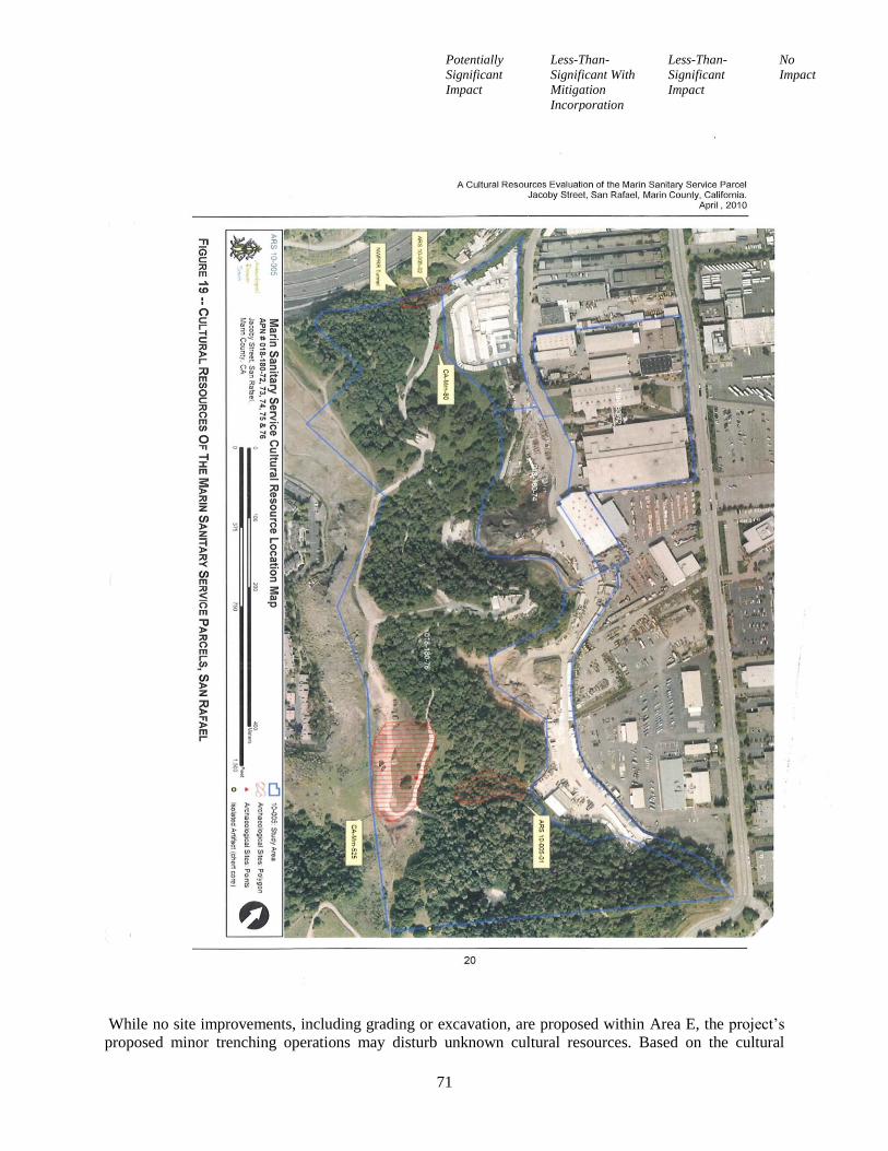
Potentially
Significant
Impact
Less-Than-
Significant With
Mitigation
Incorporation
Less-Than-
Significant
Impact
No
Impact
71
While no site improvements, including grading or excavation, are proposed within Area E, the project’s
proposed minor trenching operations may disturb unknown cultural resources. Based on the cultural
Potentially
Significant
Impact
Less-Than-
Significant With
Mitigation
Incorporation
Less-Than-
Significant
Impact
No
Impact
72
resource evaluation for the project, it is recommended that standard mitigation measures should be
incorporated. Compliance with recommended Mitigation Measures Cultural Resources-1, -2, -3 and -4
would ensure that disturbance of recorded or unknown cultural resources during project’s excavation,
grading and construction activities would be reduced to a less-than-significant level.
Recommended Mitigation Measures:
The following measures shall apply to work in the vicinity of cultural resources, as shown on Figure 19 of
the cultural resources report, Source Reference 13 (e.g., generally in the open space lands Area E):
CR-1: To mitigate potential damage to any recorded cultural resource during grading, excavation or soil
disturbance activities in the vicinity of any recorded cultural resource, including activities to remove
concrete improvements to the existing fire road network, archaeological investigation should be
undertaken to determine the exact boundary of the remaining deposit, the condition of the remaining
deposit and the potential for significance of the archaeological site. A Native American monitor should
also be present. The procedures to follow for archaeological and Native American monitoring of a
cultural resource site are presented in Cultural Resources mitigation measures CR-2 and CR-3.
CR-2: To mitigate potential damage to any recorded cultural resource during grading, excavation or soil
disturbance activities in the vicinity of any recorded cultural resource, archaeological monitoring shall
occur, based on the following procedures:
Monitoring will consist of directly watching the major excavation process. Monitoring will occur
during the entire work day and will continue on a daily basis unit the depth of excavation has
been reached at which the cultural resource no longer is present. This depth is estimated as
usually five feet (5’) below existing grade but may require modification as determined by the
monitoring archaeologist and the observed soil conditions.
Spot checks will consist of partial monitoring the progress of excavation over the course of the
project. Monitoring all spoils materials, open excavation, recently grubbed areas, and other soil
disturbances will be inspected. The frequency and duration of spot checks will be based on the
relative sensitivity of the exposed soils and active work areas. The monitoring archaeologist shall
determine the relative sensitivity of the cultural resource site.
If prehistoric human interments (human burials) are encountered within the native soils of the
cultural resource site, all work shall be halted in the immediate vicinity of the find. The County
Coroner, project superintendent, and the project planner (or a representative of the Lead Agency,
the City of San Rafael Community Development Department, Planning Division) shall be
contacted immediately. The procedures to be followed at this point are prescribed by law.
If significant cultural deposits other than human burials are encountered, the project shall be
modified to allow the artifacts or features to be left in place, or the archaeological consultant shall
undertake the recovery of the deposit or feature. Significant cultural deposits are defined as
archaeological artifacts or features that associate with the prehistoric period, the historic era
Mission and Pueblo Periods and the American era up to 1900.
Whenever the monitoring archaeologist determines that potentially significant remains or human
burials have been encountered, the piece of equipment that encounters the suspected deposit will
be stopped, and the excavation inspected by the monitoring archaeologist. If the suspected
remains prove to be non-significant or non-cultural in origin, work shall recommence
immediately. If the suspected remains prove to be part of a significant deposit, all work shall be
halted in that location until removal has been completed. If human remains are found, the County
Coroner (or designated representative) shall be contacted to evaluate the discovered remains and
Potentially
Significant
Impact
Less-Than-
Significant With
Mitigation
Incorporation
Less-Than-
Significant
Impact
No
Impact
73
implement proper contacts with pertinent Native American representatives through the Native
American Heritage Commission (NAHC).
Equipment stoppages shall only involve those pieces of equipment that have actually encountered
significant or potentially significant deposits, and should not be construed to mean a stoppage of
all equipment on the site unless the cultural resource deposit covers the entire site.
During temporary equipment stoppages brought about to examine suspected remains, the
monitoring archaeologist shall accomplish the necessary tasks in due speed.
CR-3: To mitigate potential damage to any recorded cultural resource during grading, excavation or soil
disturbance activities in the vicinity of any recorded cultural resource, Native American monitoring shall
occur whenever archaeological monitoring is required or whenever prehistoric Native American cultural
deposits are encountered or discovered. As recommended by the Native American Heritage Commission
(NAHC), the Native American monitoring consultant shall have the following knowledge and abilities:
Knowledge of local historic and prehistoric Native American village sites, culture, religion,
ceremony and burial practices.
Knowledge and understanding of California Health and Safety Code Section 7050.5 and
California Public Resources Code Section 5097.9 et al.
Ability to effectively communicate the meaning of Health and Safety Code Section 7050.5 and
Public Resources Code Section 5097.9 et al. to Marin Sanitary Services (MSS) representatives,
including property owners, site managers, contractors and subcontractors, Native Americans, City
of San Rafael Planning staff, and archaeological monitoring representatives.
Ability to work well with local law enforcement officials and the NAHC to ensure the return of
all associated grave goods taken from a Native American grave during grading, excavation or soil
disturbance activities.
Ability to travel to known cultural resource sites within the traditional tribal territory.
Knowledge and understanding of California Environmental Quality Act (CEQA) Guidelines,
Section 15064.5 and Section 106 of the National Historic Preservation Act of 1966 (NHPA), as
amended.
Ability to advocate for the preservation in place of Native American cultural features through
knowledge and understanding of CEQA mitigation measures, as stated in CEQA Guidelines
Section 15126.4(b)(A)(B), and through knowledge and understanding of Section 106 of the
NHPA.
Ability to read topographic maps and be able to locate known cultural resource sites and reburial
locations for future inclusion in the NAHC Sacred Lands Inventory.
Knowledge and understanding of archaeological practices, including the phases of archaeological
investigation.
The Native American monitoring consultant is required to:
Ensure the presence of a Native American monitor during all earth disturbing activities in the
vicinity of any recorded cultural resource or whenever prehistoric Native American cultural
deposits are encountered or discovered.
Communicate orally and in writing with the archaeological monitoring consultant, City of San
Rafael Planning staff, representatives for MSS representatives, including property owners, site
managers, contractors and subcontractors, and any Native American organizations. The Native
American monitoring consultant will be responsible for communicating any observations or
recommendations to any Native American organizations, neighborhood groups, or individuals
that have contacted the City of San Rafael to request listing. The contact list will be supplied to
the Native American monitor.
Potentially
Significant
Impact
Less-Than-
Significant With
Mitigation
Incorporation
Less-Than-
Significant
Impact
No
Impact
74
Maintain a daily log of activities and file a report with the MSS representatives on each day that a
Native American monitor is present.
Prepare progress reports on any ‘findings’ and summarize the observations and recommendations
made in the daily reports (i.e., human remains, associated grave goods, non-human bone
fragments, beads, arrow points, and other artifacts). The progress reports will be submitted
monthly or at the completion of all approved earth disturbing activities.
Prepare a final written report at the completion of all approved earth disturbing activities,
summarizing the observations and recommendations of the daily and monthly reports and making
recommendations for future activities and procedures on the MSS site, as appropriate. The final
report should describe the monitoring process, the discovery any Native American human
remains and associated grave goods, and their final disposition. This report shall contain, at a
minimum, the following information for each discovery of human remains and associated grave
goods:
o Date of each find
o Description of remains and associated grave goods
o Date of reburial, and the geographical located of reburial, including traditional site name if
known
The final report shall include a discussion of mitigation measures taken to preserve or protect
Native American cultural features and shall be submitted to the archaeological monitoring
consultant, MSS representatives, the City of San Rafael Planning staff, and the NAHC at the
completion of all approved earth disturbing activities. Information from the report may be
included in the NAHC Sacred Lands Inventory.
Demonstrate the ability to identify archaeological deposits and potential areas of impact.
Work with the Most Likely Descendant (MLD) if human remains are encountered. A MLD will
be chosen by the NAHC if human remains are encountered. There is no guarantee that the Native
American monitoring consultant will be named as the MLD. The chosen Native American
monitoring consultant must be able to communicate with the MLD effectively, and to aid in
carrying out any procedures or tasks undertaken or recommended by the MLD.
CR-4: In the absence of specific recommendations made by the archaeological monitoring consultant, the
following general procedures shall be implemented during the finding of an artifact (i.e., any item or
object over fifty years of age):
All contractors and subcontractors shall be required to inform all of their employees that no
artifacts are to be removed from the area of the ‘find’ except through authorized procedures.
Any artifacts found at or near a recorded cultural resource are to be turned over to, or brought to
the immediate attention of, the archaeological monitoring consultant. In the absence of the
archaeological monitoring consultant, the artifact shall be delivered to the Native American
monitoring consultant, MSS representatives (i.e., property owners, site managers, contractor and
subcontractor supervisors) or the City of San Rafael Planning staff.
Whenever any artifact is found or reported, a tag should be included that indicates the following
information:
o The identity of the finder and the date of discovery
o The identify of the responsible individual to who the artifact is given
o A description of the location where the artifact was found, the approximate distance and
direction to the nearest measuring point, identification point on the project plans, or other
reliable, accurate method of locating.
o A description of the artifact that will allow it to be identified if the tag and the artifact are
separated.
Potentially
Significant
Impact
Less-Than-
Significant With
Mitigation
Incorporation
Less-Than-
Significant
Impact
No
Impact
75
The artifact, if portable, should be transported to a safe location where it can be kept until it can
be inspected by the archaeological monitoring consultant.
The following standard CEQA mitigation measure shall apply to trenching and site work located on the
developed portions of the site (e.g., generally the undeveloped strip of Area D):
CR-5: In the event of the accidental discovery of historical or unique archaeological resources
accidentally discovered during construction or recognition of any human remains in any location other
than a dedicated cemetery, there shall be no further excavation or disturbance of the site or any nearby
area reasonably suspected to overlie adjacent human remains until:
3. In the event of accidental discovery of potential resources an immediate evaluation of the find shall
be conducted by a qualified archaeologist. If the find is determined to be an historical or unique
archaeological resource, contingency funding and a time allotment sufficient to allow for
implementation of avoidance measures or appropriate mitigation should be available. Work could
continue on other parts of the building site while historical or unique archaeological resource
mitigation takes place.
4. In the event of discovery of human remains, the coroner of the county in which the remains are
discovered must be contacted to determine that no investigation of the cause of death is required. If
the coroner determines the remains to be Native American:
a. The coroner shall contact the Native American Heritage Commission within 24 hours.
b. The Native American Heritage Commission shall identify the person or persons it believes to
be the most likely descended from the deceased Native American.
c. The most likely descendent may make recommendations to the landowner or the person
responsible for the excavation work, for means of treating or disposing of, with appropriate
dignity, the human remains and any associated grave goods as provided in Public Resources
Code Section 5097.98, or
d. Where the following conditions occur, the landowner or his authorized representative shall
rebury the Native American human remains and associated grave goods with appropriate
dignity on the property in a location not subject to further subsurface disturbance.
i. The Native American Heritage Commission is unable to identify a most likely
descendent or the most likely descendent failed to make a recommendation within 24
hours after being notified by the commission.
ii. The descendant identified fails to make a recommendation; or
iii. The landowner or his authorized representative rejects the recommendation of the
descendant, and the mediation by the Native American Heritage Commission fails to
provide measures acceptable to the landowner.
(Sources: 6, 12)
c. Directly or indirectly destroy a unique
paleontological resource or site or unique
geologic feature?
Discussion:
Refer to discussion (b) above. No known paleontological or fossilized resources have been identified
within the MSS site. A large portion of the MSS site, Area E, is essentially a ‘geologic feature’; it is a
natural landform created by the geologic process or ‘plate tectonics”. The project proposes minor
trenching within the undeveloped, eastern portion Area D for the purpose of installing a new, 8”-wide and
Potentially
Significant
Impact
Less-Than-
Significant With
Mitigation
Incorporation
Less-Than-
Significant
Impact
No
Impact
76
1,125’-long, “fire flow” waterline from Andersen Drive, which is located at the base on this natural
geologic feature. The proposed trenching is relatively minor and limited to the base of the forested
hillside on the MSS site and will not significantly damage this ‘geologic feature’. No further study is
necessary.
(Sources: 6, 12)
d. Disturb any human remains, including those
interred outside of formal cemeteries?
Discussion:
Refer to discussion (b) above. The cultural resource evaluation for the project identified that in October or
November of 1955, an adult female human skeleton was found at recorded cultural resources site CA-
Mrn-80. The burial was found at the base of a ‘midden’ mound that had been badly damaged by heavy
‘land leveling’ equipment.
There are no formal cemeteries or known interred human remains within the MSS site. It is unlikely that
unknown human remains exist within the MSS site due to the steep (approximate 39% average cross
slope) hillside topography. Still, compliance with recommended Cultural Resources Mitigation Measures
CR-1 through CR-4 would ensure that any disturbance of unknown human remains is properly processed
and the appropriate interested parties notified.
Recommended Mitigation Measures:
Implement Cultural Resources Mitigation measures CR-1 through CR-5
(Sources: 6, 12)
VI. GEOLOGY AND SOILS
Would the project:
a. Expose people or structures to potential
substantial adverse effects, including the risk
of loss, injury, or death involving:
i) Rupture of a known earthquake fault,
as delineated on the most recent
Alquist-Priolo Earthquake Fault
Zoning Map issued by the State
Geologist for the area or based on
other substantial evidence of a known
fault? Refer to Division of Mines and
Geology Special Publication 42.
Discussion:
The Alquist-Priolo Earthquake Fault Zoning (AP) Act (was passed into law following the destructive
February 9, 1971, 6.6-magnitude, San Fernando earthquake) ensures public safety throughout the State of
Potentially
Significant
Impact
Less-Than-
Significant With
Mitigation
Incorporation
Less-Than-
Significant
Impact
No
Impact
77
California by prohibiting the siting of most structures for human occupancy across traces of active faults
that constitute a potential hazard to structures from surface faulting or fault creep. However, no Alquist-
Priolo Special Studies Zones are located within the City of San Rafael. The nearest known active
earthquake faults to the MSS site are the North Golden Gate Segment of the San Andreas Fault System
and the North Hayward Segment of the Hayward-Rodgers Creek Fault System, both ‘active’ faults
located approximately 10 miles to the east and west of the site, respectively. The probability of a
magnitude 6.7 or greater earthquake occurring on the North Coast San Andreas Fault or North Hayward
Fault, between 2000 and 2030, is 12% and 16%, respectively. In the event of a major earthquake in the
Bay Area, the site may be susceptible to seismic shaking and related ground failure. However, the threat
of surface rupture is remote since no known active earthquake faults cross the site. No further study is
necessary.
(Sources: 1)
ii) Strong seismic ground shaking?
Discussion:
The range of ground shaking depends on the magnitude of the earthquake, the distance from the
earthquake epicenter, the rock and soil conditions at the site, and variations in the propagation of seismic
waves from the earthquake due to complexities in the structure of the Earth's crust. As is the case with the
surrounding region, the MSS site is potentially susceptible to strong seismic ground shaking given its
proximity to the Hayward and San Andreas Faults. The project proposes limited site improvements that
include, primarily relocating container storage units. Both the existing and relocated container storage
facilities would comply with current California Building Code requirements established for seismic
safety. Thus, no unique or unusual impacts have been identified with the project. Impacts would be a less-
than-significant.
(Sources: 1)
iii) Seismic related ground failure,
including liquefaction?
Discussion:
Ground failure, including liquefaction, generally occurs when loose, saturated granular soil experiences a
sudden loss of shear strength during seismic shaking. Space between individual soil particles is filled with
water, which exerts pressure and influences how tightly these particles are pressed together. Prior to an
earthquake, the water pressure is relatively low. However, seismic shaking can cause the water pressure to
increase to the point where the soil particles can readily move with respect to each other. Ground failure
generally occurs along the tops of slopes, where ‘stiff’ soils are underlain by soft deposits. The low lying
portions of the site near Andersen Drive were historically tidally influenced lands.
The MSS site is currently comprised of five (5) adjoining parcels (A through E). The subject parcels,
identified as land use Areas A through D are relatively level, consisting of developed MSS operations
areas. The undeveloped open space Area E will remain densely forested, private open space hillside.
During multiple visual inspections in and around the MSS site, staff found no evidence indicating ground
failure. Since the project proposes limited site improvements (i.e., minor trenching and container storage
facilities relocation) subsurface geotechnical investigation has not been deemed required. Further, new
construction and the existing gabion wall are required to be designed to comply with the seismic safety
Potentially
Significant
Impact
Less-Than-
Significant With
Mitigation
Incorporation
Less-Than-
Significant
Impact
No
Impact
78
zone and soils characteristics of the site which would serve to ensure any potential risks are addressed.
This, liquefaction susceptibility associated with the proposed project is considered to be very low. This
would be a less-than-significant impact.
(Sources: 1)
iv) Landslides?
Discussion:
Refer to discussion (a.iii.) above. The geology of the MSS site is primarily Franciscan Complex Mélange
(fsr). Franciscan Complex Mélange is a 145-million year old, assemblage of pillow basalt, sedimentary
rocks such as shale, chert and greywacke sandstone, and assorted metamorphic rocks, created by the
tectonic seduction (i.e., plates moving at a average rate of 5 centimeters per year) of the oceanic Pacific
Plate with the continental North American Plate. Franciscan Complex Mélange is essentially ‘bedrock’; it
comprises the bulk of the California Coast Ranges which surround the MSS site.
Landslides are the sudden or unexpected geomorphic movement of rock, soil or a combination of the two.
The relative likelihood of land sliding is a product of essentially rock strength and steepness of slopes.
The project proposes limited site improvements (i.e., minor trenching for a new underground waterline
and container storage facilities relocation), restricted primarily to Areas A through D, the non-hillside
parcels on the MSS site. No fill from this waterline trenching is proposed to be deposited on the hillside
slopes of Area E, the forested, private open space area. No physical evidence of ground failure, including
past landslides, was observed during site inspections of the project area by planning staff. This inherently
high rock strength of the Franciscan Complex Mélange on the MSS site, together with the lack of
proposed site grading (excavation or fill) on steep slopes, present a very low landslide susceptibility for
the project.
(Sources: 1)
b. Result in substantial soil erosion or the loss
of topsoil?
Discussion:
Refer to discussion (a.iv.) above. The project proposes limited site trenching on Area D for the
installation of a new “fire flow” waterline extension. Compliance with standard grading permit
requirements would ensure that an Erosion Control Plan and/or Storm Water Pollution Prevention Plan is
required to be installed prior to issuance of a grading permit and maintained during trenching and
installation of the new waterline extension to reduce soil erosion resulting from temporary construction
activities to less-than-significant levels.
(Sources: 2, 6, 10)
c. Be located on a geologic unit or soil that is
unstable, or that would become unstable as a
result of the project, and potentially result in
on, or off, site landslide, lateral spreading,
subsidence, liquefaction or collapse?
Potentially
Significant
Impact
Less-Than-
Significant With
Mitigation
Incorporation
Less-Than-
Significant
Impact
No
Impact
79
Discussion:
Refer to discussion (a.iii. and a.iv) above.
(Sources: 1)
d. Be located on expansive soil, as defined in
Table 18-1-B of the Uniform Building Code
(1994), creating substantial risks to life or
property?
Discussion:
‘Expansive soils’ are fine-grained alluvial soils containing primarily clay. Clay materials can undergo
relatively large volume changes in response to fluctuations in water content of near-surface soils due
primarily to seasonal rainfall. As the water content increases, the soils will expand; conversely, when the
water content decreases, the soils will generally contract or shrink. Soils underlain with fifty percent
(50%) or greater abundant clays are known to have a significant expansive or swelling potential. The
geology of the MSS site is primarily Franciscan Complex Mélange (fsr), which is generally anticipated to
possess relatively low clay content and a correspondingly low soil expansion potential.
The project proposes limited site improvements (i.e., minor trenching for a new underground waterline
and container storage facilities relocation), which may be impacted by isolated unknown areas of
expansive soils. The effects of expansive soils could cause damage to the concrete foundations of the
container storage facilities or to the integrity of the waterline delivery system, depending on the level of
pressure created by soil expansion and contraction and surface water infiltration, including cracking,
settlement and uplift. Since the proposed site improvements will be designed and constructed in
compliance with the Californian Building Code standards, this would be a less-than-significant impact.
(Sources: 1, 6)
e. Have soils incapable of adequately
supporting the use of septic tanks or
alternative wastewater disposal systems
where sewers are not available for the
disposal of wastewater?
Discussion:
The proposed site improvements do not include septic tanks or alternative wastewater disposal systems.
No further study is necessary
(Sources: 6)
VII. GREENHOUSE GAS EMMISSIONS
Would the project:
a. Generate greenhouse gas emissions, either
Potentially
Significant
Impact
Less-Than-
Significant With
Mitigation
Incorporation
Less-Than-
Significant
Impact
No
Impact
80
directly or indirectly, that may have a
significant impact on the environment?
Discussion:
In 2006, Assembly Bill 32 (AB 32; the California Global Warming Solutions Act) established state
legislation requiring a statewide reduction in greenhouse gas (GHG) emissions to 1990 levels by 2020.
On December 12, 2008, the California Air Resources Board adopted an AB32 Scoping Plan, requiring
cities to achieve a 15% reduction in greenhouse gas emissions by the year 2020. On April 20, 2009, the
San Rafael City Council adopted by Resolution (No. 12725) the San Rafael Climate Change Action Plan
(CCAP) to reduce the carbon footprint of City operations and to reduce greenhouse gas emissions of San
Rafael households and businesses. The CCAP contained a proposed greenhouse gas reduction goal of
25% by the year 2020 and 80% by 2050 using 48 proposed programs. The CCAP, using data analysis
performed and provided by ICLEI (International Association of Local Governmental Initiatives) – Local
Governments for Sustainability, revealed that 61% of San Rafael’s greenhouse gas emissions is due to the
burning of fossil fuels in transportation and 34% is consumed in residential and commercial buildings
from utility needs.
On July 18, 2011, the City Council adopted the Greenhouse Gas Emissions Reduction Strategy as
Appendix E of the San Rafael Climate Change Action Plan (P11-009). Concurrently, GPA11-001 was
adopted to include the General Plan 2020 Sustainability Element policies. These amendments were
adopted in response to SB97 and changes by the Bay Area Air Quality Management District (BAAQMD)
in 2010 to update its CEQA Air Quality Guidelines for the Bay Area; requiring that projects address new
state climate change and GHG reduction requirements (consistent with AB32 goals). The GHG Emissions
Reduction Strategy plan provides an opportunity to revisit and recalculate the numerous programs
contained in the City’s Climate Change Action Plan (CCAP); previously adopted in April, 2009. A GHG
Reduction Strategy Checklist was also developed that identifies required elements that projects must
satisfy in order be compliant with the CCAP. This document is expected to be updated frequently as
programs are completed, others added and emission data is refined.
As an alternative to conducting a project-by-project GHG analysis, the BAAQMD Guidelines allow the
preparation and adoption of a GHG Emissions Reduction Plan to examine emissions and reduction
strategies at a community-wide level. This is encouraged by BAAQMD as a more proactive means of
achieving desired air quality changes. The amended CCAP GHG Reduction Strategy plan was reviewed
by BAAQMD, and meets its requirements for a Qualified Greenhouse Gas Reduction Strategy. The City
meets the BAAQMD requirement, as a Qualified Greenhouse Gas Reduction Strategy, because it includes
the following elements:
an emission inventory and projections required by SB375,
target reductions,
application of GHG reduction measures,
a checklist to require implementation of measures in a project,
monitoring and updating the GHG inventory and reduction measures every 3-5 years before 2020,
requires the annual reporting on progress of implementation of CCAP / GHG Reduction Plan
programs, and
regular monitoring of community-wide GHG levels to assure that Plan objectives are being met.
Amendments to the San Rafael Municipal Code have also been made, and are currently being pursued, to
provide legislative standards that implement the Sustainability Element and the CCAP (this has included
updates to adopt City water-efficient landscaping standards, parking paving, design and landscape
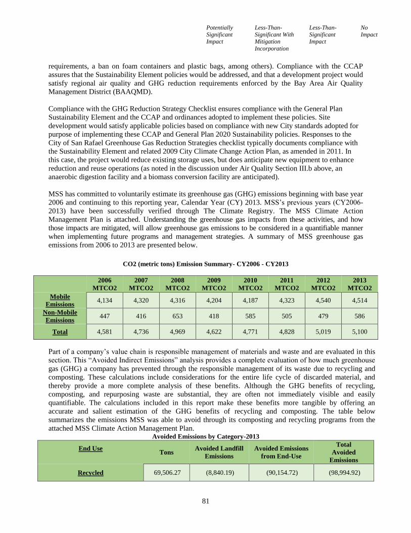
Potentially
Significant
Impact
Less-Than-
Significant With
Mitigation
Incorporation
Less-Than-
Significant
Impact
No
Impact
81
requirements, a ban on foam containers and plastic bags, among others). Compliance with the CCAP
assures that the Sustainability Element policies would be addressed, and that a development project would
satisfy regional air quality and GHG reduction requirements enforced by the Bay Area Air Quality
Management District (BAAQMD).
Compliance with the GHG Reduction Strategy Checklist ensures compliance with the General Plan
Sustainability Element and the CCAP and ordinances adopted to implement these policies. Site
development would satisfy applicable policies based on compliance with new City standards adopted for
purpose of implementing these CCAP and General Plan 2020 Sustainability policies. Responses to the
City of San Rafael Greenhouse Gas Reduction Strategies checklist typically documents compliance with
the Sustainability Element and related 2009 City Climate Change Action Plan, as amended in 2011. In
this case, the project would reduce existing storage uses, but does anticipate new equipment to enhance
reduction and reuse operations (as noted in the discussion under Air Quality Section III.b above, an
anaerobic digestion facility and a biomass conversion facility are anticipated).
MSS has committed to voluntarily estimate its greenhouse gas (GHG) emissions beginning with base year
2006 and continuing to this reporting year, Calendar Year (CY) 2013. MSS’s previous years (CY2006-
2013) have been successfully verified through The Climate Registry. The MSS Climate Action
Management Plan is attached. Understanding the greenhouse gas impacts from these activities, and how
those impacts are mitigated, will allow greenhouse gas emissions to be considered in a quantifiable manner
when implementing future programs and management strategies. A summary of MSS greenhouse gas
emissions from 2006 to 2013 are presented below.
CO2 (metric tons) Emission Summary- CY2006 - CY2013
2006
MTCO2
2007
MTCO2
2008
MTCO2
2009
MTCO2
2010
MTCO2
2011
MTCO2
2012
MTCO2
2013
MTCO2
Mobile
Emissions 4,134 4,320 4,316 4,204 4,187 4,323 4,540 4,514
Non-Mobile
Emissions 447 416 653 418 585 505 479 586
Total 4,581 4,736 4,969 4,622 4,771 4,828 5,019 5,100
Part of a company’s value chain is responsible management of materials and waste and are evaluated in this
section. This “Avoided Indirect Emissions” analysis provides a complete evaluation of how much greenhouse
gas (GHG) a company has prevented through the responsible management of its waste due to recycling and
composting. These calculations include considerations for the entire life cycle of discarded material, and
thereby provide a more complete analysis of these benefits. Although the GHG benefits of recycling,
composting, and repurposing waste are substantial, they are often not immediately visible and easily
quantifiable. The calculations included in this report make these benefits more tangible by offering an
accurate and salient estimation of the GHG benefits of recycling and composting. The table below
summarizes the emissions MSS was able to avoid through its composting and recycling programs from the
attached MSS Climate Action Management Plan. Avoided Emissions by Category-2013
End Use
Tons
Avoided Landfill
Emissions
Avoided Emissions
from End-Use
Total
Avoided
Emissions
Recycled 69,506.27 (8,840.19) (90,154.72) (98,994.92)
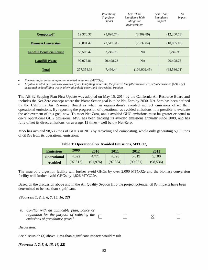
Potentially
Significant
Impact
Less-Than-
Significant With
Mitigation
Incorporation
Less-Than-
Significant
Impact
No
Impact
82
Composted* 19,370.37 (3,890.74) (8,309.89) (12,200.63)
Biomass Conversion 35,894.47 (2,547.34) (7,537.84) (10,085.18)
Landfill Beneficial Reuse 55,505.47 2,245.98 NA 2,245.98
Landfill Waste 97,077.81 20,498.73 NA 20,498.73
Total 277,354.39 7,466.44 (106,002.45) (98,536.01)
Numbers in parentheses represent avoided emissions (MTCO2e).
Negative landfill emissions are avoided by not landfilling materials; the positive landfill emissions are actual emissions (MTCO2e)
generated by landfilling waste, alternative daily cover, and the residual fraction.
The AB 32 Scoping Plan First Update was adopted on May 15, 2014 by the California Air Resource Board and
includes the Net-Zero concept where the Waste Sector goal is to be Net Zero by 2030. Net-Zero has been defined
by the California Air Resource Board as when an organization’s avoided indirect emissions offset their
operational emissions. By reporting the progression of operational vs avoided emissions, it is possible to evaluate
the achievement of this goal now. To meet Net-Zero, one’s avoided GHG emissions must be greater or equal to
one’s operational GHG emissions. MSS has been tracking its avoided emissions annually since 2009, and has
fully offset its direct emissions, on average, 19 times - well below Net-Zero.
MSS has avoided 98,536 tons of GHGs in 2013 by recycling and composting, whole only generating 5,100 tons
of GHGs from its operational emissions.
Table 3: Operational vs. Avoided Emissions, MTCO2e
Emissions 2009 2010 2011 2012 2013
Operational 4,622 4,771 4,828 5,019 5,100
Avoided (97,312) (91,976) (97,334) (99,051) (98,536)
The anaerobic digestion facility will further avoid GHGs by over 2,000 MTCO2e and the biomass conversion
facility will further avoid GHGs by 1,826 MTCO2e.
Based on the discussion above and in the Air Quality Section III.b the project potential GHG impacts have been
determined to be less-than-significant.
(Sources: 1, 2, 5, 6, 7, 15, 16, 22)
b. Conflict with an applicable plan, policy or
regulation for the purpose of reducing the
emissions of greenhouse gases?
Discussion:
See discussion (a) above. Less-than-significant impacts would result.
(Sources: 1, 2, 5, 6, 15, 16, 22)
Potentially
Significant
Impact
Less-Than-
Significant With
Mitigation
Incorporation
Less-Than-
Significant
Impact
No
Impact
83
VIII. HAZARDS AND HAZARDOUS MATERIALS
Would the project:
a. Create a significant hazard to the public or
the environment through the routine
transport, use, or disposal of hazardous
materials?
Discussion:
Setting and Impacts:
MSS operates a comprehensive, multi-faceted, waste management facility on site under permit authority from
CalRecycle. On Area A, MSS operates the Marin Household Hazardous Waste Facility (HHW) collecting
household hazardous, universal and electronic waste. Collected items include paints, oils, batteries, fertilizers,
pesticides, fluorescent light bulbs and painted or treated wood products. HHW operates under additional
permitting by the State Department of Toxic Substances Control (DTSC) and regulated by the County of Marin
Certified Unified Program Agency (CUPA). MSS will continue to operate the HHW facility under the auspices of
the Marin County Joint Powers Authority (JPA) and the City of San Rafael Fire Department. No changes in these
MSS operations are proposed.
Proposed site improvements are limited to installing new, ‘fire flow’ waterline extension from Andersen Drive
through Area D. During the construction of the site improvements and the continuing, ongoing maintenance of the
MSS site, a minor amount of hazardous materials (e.g., paints, solvents, oils, etc.) may be used but all contractors
are expected to abide by state and federal regulations regarding the transport, use, and disposal of such materials,
which would minimize exposure to, and limit transporting of, hazardous materials. This is an existing condition,
and project related impacts would be a less-than-significant.
The proposed project also involves the production of biogas generated through the anaerobic digestion
process. Biogas is composed primarily of methane but can also contain small quantities of carbon dioxide and
hydrogen sulfide. The City of South San Francisco adopted the Mitigated Negative Declaration (MND) (SCH
#2012092007) for the Blue Line Biogenic CNG Facility project in December of 2012. The Initial
Study/Mitigated Negative Declaration (IS/MND) evaluated the impacts of developing an Anaerobic Digestion
(AD) Facility of similar size and evaluated the storage of methane. The biogas would be captured and the low
quality lean gas (methane content below 20% and higher than 1%) would be destroyed in an enclosed lean gas
flare (LGF) generated during digester termination operations. Methane is not toxic, but handling methane can
be hazardous as it is ignitable and can be flammable. Methane has an ignition temperature of 1,000 degrees
Fahrenheit (°F) and is flammable at concentrations between 5 percent and 15 percent in air. Unconfined
mixtures of methane in air are not explosive; however, a flammable concentration within an enclosed space in
the presence of an ignition source can explode. Methane is buoyant at atmospheric temperatures and disperses
rapidly in air. Unintentional releases of biogas from the facility could pose risks to human health and safety.
For example, biogas could be released from a leak or rupture at the digester facility. If the gas reaches a
combustible mixture and an ignition source is present, a fire and/or explosion could occur, resulting in possible
injuries and/or deaths.
Compliance with existing safety regulations and widely-accepted industry standards would minimize the hazard
to the public and the environment. With respect to the flaring of biogas and potential fire hazards associated with
the storage and transport of methane and small quantities of other materials used in operations, the National Fire
Protection Association (NFPA) has established standards for fire protection which would be applicable to the
Potentially
Significant
Impact
Less-Than-
Significant With
Mitigation
Incorporation
Less-Than-
Significant
Impact
No
Impact
84
construction of the AD facilities. These standards have been successfully implemented by numerous waste water
treatment facilities across the country. Construction and operation of the project would be required to comply with
the California fire code and local building codes (including requirements for the installation of fire suppression
systems). Standard safety measures for anaerobic treatment facility construction and operation that would
minimize the potential for risks from unintentional releases of biogas include leak detection systems, warning
signals, and safety flares to reduce excess gas capacity. If released to the environment, methane would be
dispersed rapidly in air, minimizing the hazards of exposure.
Recommended Mitigation Measures:
Although compliance with existing laws and regulations governing the transport, use, storage, handling and
disposal of hazardous materials would likely ensure less than significant impacts, a Fire Safety Plan would be
implemented per Mitigation Measure HAZ-1 due to the combustion potential of methane.
HAZ-1: Prior to project approval, the applicant shall prepare and implement a Fire Safety Plan that outlines
fire hazards, describes facility operations procedures to prevent ignition of fires, requires regular inspection
of fire suppression systems, and provides worker training in safety procedures as well as protocols for
responding to fire incidents. The Fire Safety Plan shall be reviewed and approved by the local fire
enforcement agency.
(Sources: 1, 6, 7)
b. Create a significant hazard to the public or
the environment through reasonably
foreseeable upset and accident conditions
involving the release of hazardous materials
into the environment?
Discussion:
Refer to discussion (a) above. The project does not create any new potential hazards. As discussed above, small
quantities of hazardous materials could be used in the construction and operation of the proposed project.
Compliance with environmental laws and regulations would reduce the potential for any release of those
materials to adversely affect onsite workers, the environment or the public. There are no schools located
within a quarter mile of the proposed project. Therefore, there would be no impact related to potential
exposure of hazardous emissions or acutely hazardous materials, substances, or wastes within one-quarter
mile of a school.
The potential for accidental release of hazardous materials into the environment during the operations and/or site
improvements to the MSS site would be a less-than-significant impact due to the regulatory oversight by multiple
state, regional and local permitting agencies. No further study is necessary.
(Sources: 1, 6, 7)
c. Emit hazardous emissions or handle
hazardous or acutely hazardous materials,
substances, or waste within one-quarter mile
of an existing or proposed school?
Discussion:
Potentially
Significant
Impact
Less-Than-
Significant With
Mitigation
Incorporation
Less-Than-
Significant
Impact
No
Impact
85
Refer to discussion (a) and (d) above. The project does not result in any new hazardous emission sources. No
existing or proposed school, whether public or private, is located within one-quarter mile of the MSS site. The
closest operating public school is Bahia Vista Elementary School (125 Bahia Way), located approximately .8-mile
north of the MSS site. The closest operating private school is Trinity Preschool and Kindergarten (333 Woodland
Dr.), located approximately 1.3-mile northwest of the MSS site. No hazardous emissions would be associated
with the project and thus no impact would occur at either school. No further study necessary.
(Sources: 1, 6, 7)
d. Be located on a site which is included on a
list of hazardous materials sites compiled
pursuant to Government Code Section
65962.5 and, as a result, would it create a
significant hazard to the public or the
environment?
Discussion:
As noted above, the project does not result in any new activities or uses on the site, aside from legally permitted
storage use expansion in Areas B and D. No portion of the MSS site is included on the State Department of Toxic
Substances Control’s Hazardous Waste and Substances Site List (DTSC’s “Cortese List”) under Government
Code Section 65962.5. The closest active (active as of 12/6/2011) “Cortese List” site is the San Francisco Nike
Battery 93, an former Army anti-aircraft control guided missile launch and defense command facility located
within the Harry A. Barbier Memorial Park, approximately 5 miles north of the MSS site. The closest inactive
(deemed needing evaluation for potential PCB – Polychlorinated Biphenyl – contaminants as of 3/15/1995)
“Cortese List” site is the PG&E Utility Corporation Yard, located at 1220 Andersen Drive, immediately north,
and adjacent to, Area D. No further study is necessary.
(Sources: 1, 6, 7)
e. For a project located within an airport land
use plan or, where such a plan has not been
adopted, within two miles of a public airport
or public use airport, would the project
result in a safety hazard for people residing
or working in the project area?
Discussion:
The MSS site is not located within an adopted airport land use plan. The MSS site is also not located within two
miles of a public airport or public use airport. The nearest public airport or public use airport is the 120-acre,
publicly-owned, Marin County Airport at Gnoss Field in Novato, which is located approximately 15 miles north
of the MSS site. No further study is necessary.
(Source: 1)
f. For a project within the vicinity of a private
airstrip, would the project result in a safety
hazard for people residing or working in the
Potentially
Significant
Impact
Less-Than-
Significant With
Mitigation
Incorporation
Less-Than-
Significant
Impact
No
Impact
86
project area?
Discussion:
The MSS site is not located in the vicinity of a private airstrip or privately-owned airport facility. The MSS site is
located approximately six miles south of the nearest small private airstrip; the 120-acre, San Rafael Airport site
located in North San Rafael. No further study is necessary.
(Source: 1)
g. Impair implementation of or physically
interfere with an adopted emergency
response plan or emergency evacuation
plan?
Discussion:
The project proposes to update the existing Master Use Permit at the MSS site to allow the continued waste
management and recycling operations in Areas A through D. The site is not within an emergency evacuation
route. City departments, including the Fire Department, have reviewed the project and determined adequate
emergency access to the MSS site currently exists and the proposed site improvements would have negligible or
no impact on providing continued emergency access, response or evacuation if needed. The MSS site is located
approximately 0.5-miles west of the San Rafael Corporation Yard, a ‘primary’ emergency shelter site for the City.
No further study is necessary
(Sources: 1)
h. Expose people or structures to a significant
risk of loss, injury or death involving
wildland fires, including where wildlands are
adjacent to urbanized areas or where
residences are intermixed with wildlands?
Discussion:
As noted in the project description, no increase in existing MSS facility primary and ancillary uses are proposed.
The private open space Area E is located within the City’s Wildland-Urban Interface very high severity zone
(WUI) in which specific combustible vegetation management standards are required in order to create 100’
defensible space around structures. The project has resulted in removal of wood storage from the Area E, and
routine vegetation management of this area would be permitted to continue. The San Rafael Fire Department has
reviewed the project and determined that the site would comply with the City’s WUI Ordinance. Impacts would
be less-than-significant. No further study is necessary.
(Sources: 1)
IX. HYDROLOGY AND WATER QUALITY
Would the project:
a. Violate any water quality standards or waste
Potentially
Significant
Impact
Less-Than-
Significant With
Mitigation
Incorporation
Less-Than-
Significant
Impact
No
Impact
87
discharge requirements?
Discussion:
The MSS site operates under compliance with a Stormwater Pollution Prevention Program (SWPPP) on file with
the State Water Resources Control Board (SWRCB). The natural drainage pattern for the MSS site traverses in a
southwest-northeast trending direction, from San Quentin Ridge, down Area E and through Areas B, C and D. A
system of private culverts and open channels drain surface water runoff into public storm drain catch basins
located north of Area B, within the Jacoby Street ROW, and north of Area A, within the Andersen Drive ROW.
The project proposes bioswale and minor drainage inlet improvements. Slope and erosion control measures have
been identified in project plans BH-1 and RV-1. Further, a grading permit shall be required by the Department of
Public Works (DPW) for site trenching work required to install new fire lines. DPW shall review and approve
erosion control and stormwater pollution prevention measures. This standard review and permit requirement
would ensure water quality runoff and erosion and sediment control impacts would be less-than-significant.
(Sources: 6, 9, 10)
b. Substantially deplete groundwater supplies
or interfere substantially with groundwater
recharge such that there would be a net
deficit in aquifer volume or a lowering of the
local groundwater table level (e.g., the
production rate of pre-existing nearby wells
would drop to a level which would not
support existing land uses or planned uses
for which permits have been granted)?
Discussion:
Refer to discussion (a) above. The project does not propose the drilling, construction, reconstruction, or
installation of water wells for the purpose of using, extracting or drawing water located underground. There are no
known existing private wells on or near the project area. The proposed site improvements are limited, primarily,
to at-grade construction activities with some minor below ground trenching for the installation of a new, “fire
flow” waterline extension, which would have the effect of increasing the amount of impervious surface area
slightly since the relocated container storage facility is required to be installed on an all-weather surface
(concrete) for access as part of their proposed ‘alternative means of fire protection’. A majority of the MSS site –
approximately 50 acres (nearly all of Area E) or approximately 61% of the 82.14-acre site – would continue to
remain in a natural state. It is not expected that the project’s proposed minor site improvements would
significantly impact or impede the flow or volume of existing groundwater levels. No further study is necessary.
(Sources: 1, 6)
c. Substantially alter the existing drainage
pattern of the site or area, including through
the alteration of the course of a stream or
river, in a manner which would result in
substantial erosion or siltation on- or off-
site?
Potentially
Significant
Impact
Less-Than-
Significant With
Mitigation
Incorporation
Less-Than-
Significant
Impact
No
Impact
88
Discussion:
Refer to discussions (a) and (b) above. The proposed site improvements would not substantially alter the existing
drainage pattern or capacity on the MSS site in a manner that would result in substantial erosion or siltation on- or
off-site. Existing private drainage culverts and channels would not be altered and current runoff flows and
capacities would continue to occur. Further, enhancement of existing site conditions is proposed with an new
drainage inlet at Jacoby Street and bioswales installed on the site, in compliance with City Public Works
Department requirements to improve stormwater water quality conditions. As conditioned, the project would
improve existing conditions and have no adverse environmental impacts. No further study is necessary.
(Sources: 6, 9, 10)
d. Substantially alter the existing drainage
pattern of the site or area, including through
the alteration of the course of a stream or
river, or substantially increase the rate or
amount of surface runoff in a manner which
would result in flooding on- or off- site?
Discussion:
Refer to discussions (a) and (b) above. The proposed site improvements would not substantially alter the existing
drainage pattern on the MSS site or substantially increase the rate or amount of surface runoff in a manner which
would result in flooding on- or off-site. No further study is necessary.
(Sources: 6)
e. Create or contribute runoff water which
would exceed the capacity of existing or
planned stormwater drainage systems or
provide substantial additional sources of
polluted runoff?
Discussion:
Refer to discussions (a) and (b) above. The proposed site improvements would not create or contribute runoff
water which would exceed the capacity of existing storm water drainage systems or provide substantial additional
sources of polluted runoff. No further study is necessary.
(Sources: 6, 9, 10)
f. Otherwise substantially degrade water
quality?
Discussion:
Refer to discussions (a) and (b) above. The proposed additional site work and improvements would be subject to
building and grading permit requirements, and would not substantially degrade water quality. Project impacts
would be less-than-significant.
Potentially
Significant
Impact
Less-Than-
Significant With
Mitigation
Incorporation
Less-Than-
Significant
Impact
No
Impact
89
(Sources: 6, 9, 10)
g. Place housing within a 100-year flood
hazard area as mapped on a federal Flood
Hazard Boundary or Flood Insurance Rate
Map or other flood hazard delineation map?
Discussion:
No housing is proposed as part of the project. No further study is necessary.
(Sources: 1, 6, 14)
h. Place within a 100-year flood hazard area
structures which would impede or redirect
flood flows?
Discussion:
This site proposes no new structure, thus would have no new impacts. According to 2009 Federal Emergency
Management Agency (FEMA) Flood Insurance Rate Maps (FIRMs) affecting the MSS site (Panel No.
06041C0459D and 0641C0478D), the northern portion of Area A, along the Andersen Drive frontage, and the
eastern portion of Area D (approximately 825’) are located in Zone AE with a 1% annual chance of flooding
(100-year flood) with a water surface elevation of 9 feet. The remainder of Area A is located with Zone X with a
0.2% annual chance of flooding. Areas B, C, most of D and E are located outside the 0.2% annual chance of
flooding (500-year flood). The minor site improvements proposed by the project include a new, “fire flow’
waterline extension from Andersen Drive through Area D, along the eastern portion of the MSS site. As a
condition of approval, Marin Municipal Water District (MMWD) is requiring the installation of an above-grade
backflow facility on Area D in conjunction with the installation of the new waterline extension. Negligible
grading may be required for the installation of this above-grade backflow facility. The above-grade backflow
facility itself is not anticipated to significantly impede or redirect flood flows within those portions of Area D
which are currently located within Zone AE (a 100-year flood hazard area). No new structures, significant
property improvements or activities are proposed within designated food zones. No further study is necessary.
(Sources: 1, 6, 14)
i. Expose people or structures to a significant
risk of loss, injury or death involving
flooding, including flooding as a result of the
failure of a levee or dam?
Discussion:
The project does not propose new housing or structures on the MSS site. There is no dam structure on the MSS
site or in the vicinity. A levee exists along the San Rafael Bay, approximately 3,000 feet east of Area D (eastern
portion of the MSS site), within the Jean and John Starkweather Shoreline Park. Shoreline Park is a privately-
(easement protected) and publicly-owned linear open space/multi-use trail. Generally, both the southern and
northern sections of the levee have been improved as part of the Shoreline Park; while the middle section of the
levee is unimproved and the 165-acre, privately-owned parcels, are undeveloped. These undeveloped, shoreline
parcels (common known as “Canalways”) are predominantly low-lying wetlands which are located adjacent to

Potentially
Significant
Impact
Less-Than-
Significant With
Mitigation
Incorporation
Less-Than-
Significant
Impact
No
Impact
90
City-owned parcels and currently help in maintaining flood control for East San Rafael. The project does not
propose to modify, alter or remove any portion of this existing levee located within Shoreline Park and along San
Rafael Bay. No further study is necessary.
(Sources: 1, 6, 14)
j. Inundation by seiche, tsunami, or mudflow?
Discussion:
See discussions (h) and (i) above. State Department of Conservation maps, using data provided by the United
States Geological Survey (USGS), and Association of Bay Area Governments maps, using data provided by the
California Emergency Management Agency (CalEMA), California Geologic Survey (CGS) and the University of
Southern California (USC), both indicate that the MSS site is not susceptible to tsunami inundation.
San Francisco Bay Conservation and Development Commission (BCDC) maps, using data provided by the
USGS, indicate that global warming may result in a 16” sea rise by 2050 and a 55” sea rise by 2100 along
shoreline areas within the San Francisco Bay due to global warming. While these BCDC maps are informational
only, they show inundation areas that are similar to FIRM flood zone hazard areas. If current modeling is correct,
the northern portion of Area A, along the Andersen Drive frontage, and the eastern portion of Area D
(approximately 825’), could be inundated with sea rise flooding by 2050 if global warming trends continue at
their existing pace. If current modeling is correct, the remainder of Area A could be inundated with sea rise
flooding by 2100 if global warming trends continue at their existing pace. While there is a potential risk of
isolated sea rise inundation at the MSS site, it poses a less than significant impact since the project proposes no
new housing or structures. No further review is necessary.
(Sources: 1, 6, 14)
X. LAND USE AND PLANNING
Would the project:
a. Physically divide an established community?
Discussion:
The MSS site is comprised of five (5) adjoining parcels (Parcels A through E) located at the end of Jacoby Street,
a city-maintained, surface street accessed by Andersen Drive, which terminates directly at the site. Historically,
the Jacoby Street right-of-way (ROW) extended through the MSS site. In 1984, the City of San Rafael approved
vacation or abandonment of approximately one-half of the public ROW. In 1996, the City of San Rafael approved
lot line realignment of the parcels commonly owned by MSS. Four (4) of the parcels (Parcels A through D) are
relatively flat and developed with the current MSS operations, providing municipal solid waste collection and
recycling and composting services; the fifth parcel (Parcel E) is an undeveloped, densely forested, private open
space hillside.
The project proposes to create an updated, comprehensive development and operations plan for Parcels A through
D on the MSS site. No development or operations are proposed on Parcel E, with the exception of legalizing
concrete improvements to existing fire roads. Further, the five separate parcels previously approved for the project
use and open space areas would be combined as a single parcel through a lot consolidation, and the work and
open space areas would be redesignated as land use ‘Areas’.
Potentially
Significant
Impact
Less-Than-
Significant With
Mitigation
Incorporation
Less-Than-
Significant
Impact
No
Impact
91
The project does not propose any new residential subdivisions, which both the existing General Plan land use
designations (Industrial and Conservation) and the zoning classifications (Industrial and Planned Development)
prohibits on the MSS site. The project does not propose to have the City re-establish the Jacoby Street ROW
through the developed portion of the MSS site. Due to the proposed continuation of the MSS operations within
Areas A through D and the lack of significant proposed site improvements, the project would not physically
divide an established community. No further study is necessary.
(Sources: 1, 2, 6)
b. Conflict with any applicable land use plan,
policy, or regulation of an agency with
jurisdiction over the project (including, but
not limited to the general plan, specific plan,
local coastal program, or zoning ordinance)
adopted for the purpose of avoiding or
mitigating an environmental effect?
Discussion:
The proposed project has been reviewed for consistency with the applicable policies of the San Rafael General
Plan 2020 and the applicable sections of Title 14 of the San Rafael Municipal Code (the Zoning Ordinance) and it
has been determined that it would not conflict with any specific regulation or policy adopted for the purpose of
avoiding or mitigating environmental effects. The project proposes to Rezone Parcel A (land use Area A) from
Industrial (I) to Planned Development (PD) in order to approve an overall development plan for the entire MSS
site and to be consistent with the San Rafael General Plan 2020, which requires PD zoning for development of
sites larger than five acres. Further, the rezoning would not change the existing land use of the site, which is
designated for Industrial land uses. Solid waste management facilities and related ancillary activities and uses are
anticipated in the Industrial land use category, Consistent with General Plan 2020 Land Use Policy 23, Exhibit 11.
General Plan 2020 policies have also been implemented by adoption of the San Rafael Zoning Code and San
Rafael Design Guidelines, and Climate Change Action Plan. The project has been evaluated and subjected to
compliance with all applicable zoning standards and design criteria, which are further incorporated into the
revised PD zoning standards that are proposed to be amended for the project. The development remains subject to
City of San Rafael Use Permit, Design Review and related entitlement review requirements. The project complies
with maximum industrial floor area ratio limits of 0.38 and standard 36 foot height limit, as discussed in the
Project Description above. Further, the subject entitlements and future development would be reviewed for
compliance the zoning and design criteria, that would assure compliance with City zoning and general plan
policies would be achieved.
Based on this discussion, it has been determined that the project as proposed remains substantially consistent with
the underlying General Plan 2020 Industrial land use designation and all pertinent General Plan 2020 policies that
apply to the development, and which have been further implemented in the San Rafael Zoning Code and San
Rafael Design Guidelines. No further study is necessary.
(Sources: 1, 2, 6, 11)
c. Conflict with any applicable habitat
conservation plan or natural community
conservation plan?
Potentially
Significant
Impact
Less-Than-
Significant With
Mitigation
Incorporation
Less-Than-
Significant
Impact
No
Impact
92
Discussion:
No active habitat conservation plan or natural community conservation plan applies to the MSS site. No further
study is necessary.
(Sources: 1)
XI. MINERAL RESOURCES
Would the project:
a. Result in the loss of availability of a known
mineral resource that would be of value to
the region and the residents of the state?
Discussion:
No known mineral resources would be impacted by the proposed project. Mineral resources on the project site are
limited to Franciscan Mélange (fsr) geologic assemblage. The project’s Cultural Resource evaluation identified a
prehistoric site, one of the only Native American quarries known to central Marin County, located along the
ridgeline on Area E. Additionally, the former Hutchison Quarry, located immediately south of the San Quentin or
Bartel Ridge, within the corporation boundaries for the City of Larkspur, provided quarried rock materials to the
adjacent Remillard Brick Kiln for the rebuilding of San Francisco after the 1906 Earthquake. Both the Hutchison
Quarry and the Remillard Brickyard have ceased operations and their sites have been redeveloped with
commercial and residential uses. The San Rafael Rock Quarry, the only active commercial rock quarry operating
in Marin County, is located approximately 2.85-miles northeast of the MSS site. The project does not propose to
interfere with the continued operation of the San Rafael Rock Quarry. The project also does not propose to disturb
the recorded quarry site on Area E, which has been damaged or partially destroyed by grading activities at the
time the fire roads were paved. No further study is necessary.
(Sources: 1)
b. Result in the loss of availability of a
locally-important mineral resource recovery
site delineated on a local general plan,
specific plan or other land use plan?
Discussion:
Please refer to (a) discussion above. The project site is not identified as an important mineral resource recovery
site in the San Rafael General Plan 2020 or any other existing land use plan. The closest known mineral resource
recovery site is the commercial quarry owned and operated currently by Dutra Properties and located
approximately 2.85-miles northeast of the MSS site. No further study is necessary.
(Sources: 1)
XII. NOISE
Would the project:
a. Exposure of persons to or generation of
Potentially
Significant
Impact
Less-Than-
Significant With
Mitigation
Incorporation
Less-Than-
Significant
Impact
No
Impact
93
noise levels in excess of standards
established in the local general plan or noise
ordinance, or applicable standards of other
agencies?
Discussion:
The MSS site is surrounded by industrial (PG&E service yard and Golden Gate Transit bus yard) and building
material (Golden State Lumber and Rafael Lumber yards) uses to the north, the public/quasi-public (Central
Marin Sanitation Agency Wastewater Treatment Plant) uses to the west, the incorporated boundaries for the City
of Larkspur to the south, and the U.S. Highway 101 and SMART (Sonoma Marin Area Rail Transportation) right-
of-ways (ROW) to the west. The MSS site is located approximately 400’ west of the closest residences within the
City of San Rafael boundaries, separated by both the Highway 101 and SMART ROWs. The closest residences to
the MSS site are located approximately 200’ south of San Quentin Ridge (Area E), in the City of Larkspur.
The San Rafael General Plan 2020 has adopted policies to minimize noise impacts from new nonresidential
development on neighboring residential and nonresidential uses. Noise Policy N-4 establishes standards of
significance or acoustical criteria where new nonresidential uses shall not increase the existing noise levels at the
property line of nearby residential uses by more than Ldn 3dB, or create noise impacts that would increase noise
levels to more than Ldn 60 dB, whichever is the more restrictive standard. Noise Policy N-4 also establishes
standards of significance or acoustical criteria where new nonresidential use shall not increase the existing noise
levels at the property line of nearby nonresidential/industrial uses by more than Ldn 5dB, or create noise impacts
that would increase noise levels to more than Ldn 70 dB, whichever is the more restrictive standard. The San
Rafael Zoning Ordinance (Section 14.16.260) establishes these same thresholds.
Similarly, the San Rafael Municipal Code has an adopted Noise Ordinance (Chapter 8.13), which establishes
maximum daytime noise limits of 50 dBA for constant noise and 60 dBA for intermittent noise when measured on
any neighboring residential property and 70 dBA constant noise and 60 dBA intermittent noise when measured on
any neighboring nonresidential/industrial property. Allowable nighttime noise levels (6 p.m. - 7 a.m., Mondays
through Fridays, and 6 p.m. - 9 a.m. Saturdays) are 10 dBA lower when measured on any neighboring residential
property. The Noise Ordinance provides an exception for temporary construction noise impacts. Construction
activities are permitted between the hours of 7:00 a.m. and 6:00 p.m., Monday through Friday, and 9:00 a.m. and
6:00 p.m. on Saturdays, provided that the noise level at any point outside of the property plane of the MSS site
shall not exceed ninety (90) dBA. The noise exception for construction activities is precluded on Sundays and
holidays.
The project would continue to generate operational noise at appropriate industrial levels. A vast majority of the
MSS operations are conducted within enclosed structures or buildings which reduce or mitigate noise volume.
These same structures or buildings also help to block or reduce noise volumes for those portions of the MSS
operations conducted outside. Area E, the private open space hillside, further provides an on-site, noise reducing
natural landform. U.S. Highway 101, located immediately west of the MSS site, and Interstate 580, located north
and east of the MSS site, additionally create continuous ambient background noise which serves to mitigate on-
site noise volume.
Wood chipping is currently happening within MRRC, where the biomass chips are hauled off-site to a biomass
facility in the Central Valley. Instead, 40 tons per days of biomass chips will stay on-site, Operation of the
biomass conversion facility would result in the use of noise‐generating equipment to deliver biomass chips from
MRRC. The noise generated from the use of heavy equipment would be similar to noise generated by existing
equipment that is currently used for operations. Therefore, because noise generated from biomass haul trucks
Potentially
Significant
Impact
Less-Than-
Significant With
Mitigation
Incorporation
Less-Than-
Significant
Impact
No
Impact
94
would be similar to existing noise sources, these activities would not result in substantial increase in noise at
sensitive receptors.
The proposed biomass conversion facility would be manufactured by Phoenix Energy, which recently installed a
similar unit in Merced County (Phoenix Energy 2011). Sound readings were conducted at this existing unit in
order to determine the potential noise levels at the project site with project implementation. In addition,
manufacturer specifications were obtained for the Caterpillar G3516 TA electrical generation equipment that
would be used in conjunction with the unit and would be located on the same pad. When open to the air, the
mechanical and exhaust noise from this equipment is estimated to be 81.3 dBA to 91.6 dBA at 50 feet from the
engine. However, this equipment would be completely enclosed in a steel container provided by the manufacturer
and would include sound attenuators along air intake and air outlet paths. In addition, an exhaust silencer would
be installed to further reduce noise levels. With these noise attenuation features in place, sound levels in any
direction would not exceed 65 dBA at a distance of approximately 30 feet from the unit.
The project remains subject to the City’s Noise Ordinance at all times, during operational use and construction.
The project would not result in significant noise related impacts.
(Sources: 1, 2, 6)
b. Exposure of persons to or generation of
excessive ground borne vibration or ground
borne noise levels?
Discussion:
No excessive, sustained ground borne vibration or ground borne noise levels are expected to result during project
operation or construction. The project does not propose pile-driving or drilling construction activity or blasting
with explosives. No significant noise impacts are anticipated from trenching required for the installation of a new,
“fire flow” waterline extension from Andersen Drive through Area D. No further study is necessary.
(Sources: 6)
c. A substantial permanent increase in ambient
noise levels in the project vicinity above
levels existing without the project?
Discussion:
Please refer to (a) discussion above. The predominant land use in the vicinity of the MSS site is ‘industrial’,
where the San Rafael General Plan, the San Rafael Zoning Ordinance and the adopted Noise Ordinance allow for
relatively high noise levels (70 dBA constant noise and 60 dBA intermittent noise). The MSS site and immediate
vicinity are affected already by relatively high ambient noise levels due to these predominant industrial land uses
and to the proximity of both the U.S. Highway 101 and Interstate 580 transportation corridors. The proposed site
improvements would not generate a substantial, permanent increase in this ambient noise level given that any new
permanently-installed noise-generating mechanical equipment at the biomass conversion facility will be enclosed.
No further study is necessary.
(Sources: 6)
d. A substantial temporary or periodic increase
Potentially
Significant
Impact
Less-Than-
Significant With
Mitigation
Incorporation
Less-Than-
Significant
Impact
No
Impact
95
in ambient noise levels in the project vicinity
above levels existing without the project?
Discussion:
Please refer to (a) and (c) discussions above. While the current ambient noise levels on the MSS site and in the
vicinity are relatively high due to predominant industrial uses and proximity to major transportation corridors
(U.S. Highway 101 and Interstate 580), the proposed limited site improvements (removal of excess container
storage and minor trenching to install a new, “fire flow” waterline extension from Andersen Drive) would
generate a temporarily increase ambient noise level. Impacts from this work would not be anticipated to exceed
the industrial noise limits.
(Sources: 2, 6)
e. For a project located within an airport land
use plan or, where such a plan has not been
adopted, within two miles of a public airport
or public use airport, would the project
expose people residing or working in the
project area to excessive noise levels?
Discussion:
The MSS site is not located within an adopted airport land use plan. The MSS site is also not located within two
miles of a public airport or public use airport. The nearest public airport or public use airport is the 120-acre,
publicly-owned, Marin County Airport at Gnoss Field (DVO) in Novato, which is located approximately 15
miles north of the MSS site. The Marin County Airport at Gnoss Field is staffed and maintained by the Marin
County Department of Public Works Department and currently operates under an Airport Master Plan with
published noise abatement procedures in effect. No further study is necessary.
(Sources: 1)
f. For a project within the vicinity of a private
airstrip, would the project expose people
residing or working in the project area to
excessive noise levels?
Discussion:
The MSS site is not located in the vicinity of a private airstrip or privately-owned airport facility. The MSS site is
located approximately six miles south of the nearest private airstrip; the 120-acre, San Rafael Airport site located
in North San Rafael, which has established voluntary measures to minimize noise exposure impacts from aircraft
on surrounding residential neighborhoods. No further study is necessary.
(Sources: 1)
XIII. POPULATION AND HOUSING
Would the project:
a. Induce substantial population growth in an
Potentially
Significant
Impact
Less-Than-
Significant With
Mitigation
Incorporation
Less-Than-
Significant
Impact
No
Impact
96
area, either directly (for example, by
proposing new homes and businesses) or
indirectly (for example, through extension of
roads or other infrastructure)?
Discussion:
The project does not propose any new residential units or businesses that would directly induce substantial
population growth. The project also proposes no new, publicly-accessible roads into the MSS site or major,
growth-inducing, infrastructure improvements. The project proposes limited improvements for the site, primarily
for increased ‘fire protection’.
Specifically, as an alternative to installing fire sprinkler systems at both the existing container storage facility on
Area B and the new, relocated container storage facility on Area C, the project proposes to connect together or
‘loop’ existing private 8” waterline extensions from both Andersen Drive and Jacoby Street on Area A and install
four (4) new fire hydrants on Areas B and C to complement the system of eight (8) existing fire hydrants on Area
A and B. The project also proposes to install a new, private 8” waterline extension from Andersen Drive through
Area D and two (2) new fire hydrants.
The project further proposes to legalize concrete improvements made to the existing network of fire roads located
on Area E, the private open space area. This system of dirt fire roads have existed on Area E since at least 1942.
Between 1997 and 2007, these fire roads were improved by MSS with concrete and curbing in order to provide
all-weather access to firewood storage and curing areas within Area E. Access to these improved fire roads within
Area E is limited by control gates located down slope on Areas B and C.
The existing Master Use Permit (UP96-008) approved one (1) caretaker’s unit on either Area B or C. This unit
was never constructed and does not currently exist on the MSS facility site. The project though proposes to
preserve the option to construct the caretaker’s unit on the site.
The operational areas are designated Industrial (I) on the General Plan 2020 land se map while Area E is
designated Conservation. Residential uses are not permitted. The project would have no impacts on housing,
population or infrastructure. No further study is necessary.
(Sources: 1)
b. Displace substantial numbers of existing
housing, necessitating the construction of
replacement housing elsewhere?
Discussion:
The project does not propose to demolish or convert any existing housing units. No housing units currently exist
on the MSS facility site. Until 1978, a single-family residence was located on the MSS facility site, on Area E,
with an address of ‘524 Jacoby Street’. At the time it was recorded as part of the survey of historic structures by
the City of San Rafael, the condition of the residence was noted as “deteriorated”. The building is no longer
present; it is not clear when, why and how it was removed. The partial concrete remains of the building’s
basement floor and wall remain and have been reused to construct a metal storage building along the improved
fire road within Area E. A previously approved caretaker’s unit was never constructed on the site, though the
project proposes to preserve the option to construct the caretaker’s unit on either Area B or C. No further study is
necessary.
Potentially
Significant
Impact
Less-Than-
Significant With
Mitigation
Incorporation
Less-Than-
Significant
Impact
No
Impact
97
(Sources: 1, 6)
c. Displace substantial numbers of people,
necessitating the construction of replacement
housing elsewhere?
Discussion:
Please refer to (b) discussion above. No further study is necessary.
(Sources: 1, 6)
XIV. PUBLIC SERVICES
Would the project result in substantial adverse
physical impacts associated with the provision of
new or physically altered governmental facilities,
need for new or physically altered governmental
facilities, the construction of which could cause
significant environmental impacts, in order to
maintain acceptable service ratios, response
times or other performance objectives for any of
the public services:
a. Fire protection?
Discussion:
The project proposes to integrate and expand the existing “fire flow” waterline delivery and fire hydrant system
on the MSS site. Specifically, as an alternative to installing fire sprinkler systems for the expanded container
storage uses, the project proposes to extend the private 8” waterline on Area A and install three (3) new fire
hydrants in Areas B and C to complement the system of eight (8) existing fire hydrants in Areas A and B. The
project also proposes to install a new, private 8” waterline extension through Area D and three (3) new fire
hydrants. As a result, all new and existing fire hydrants would be within a maximum 400’ fire hose path to any
container storage unit. Fire lanes would maintain a minimum 26’ width for 20’ of either side of each fire hydrant.
Both the new and existing fire hydrant waterlines would maintain a minimum assumed fire flow of 1,750 gallons
per minute @ 20 PSI (pounds per square inch) as required by the San Rafael Fire Department.
New metal vehicle gates, a minimum 20’-wide with “Knox-Box” lockboxes, would provide controlled public
access to these two container storage facilities while also providing rapid entry for emergency and fire protection
services. The project also proposes to legalize the improvements (i.e., concrete road base and curbing) made to
the network of historic fire roads throughout Area E, the private open space area. These improvements would
provide all-weather access to large portions of Area E, including San Quentin or Martels Ridge, for emergency
and fire protection services, if needed.
No new governmental or service-related facilities would need to be constructed to serve fire protection for the
project. Fire protection services are currently provided, and would continue to be provided, by the San Rafael Fire
Department (SRFD) – Fire Station #4, which is located at 46 Castro Avenue, approximately one-third of a mile
north of the MSS site. SRFD-Fire Station #4 is currently staffed by no less than three employees at one time, 24
Potentially
Significant
Impact
Less-Than-
Significant With
Mitigation
Incorporation
Less-Than-
Significant
Impact
No
Impact
98
hours per day, and seven days per week, including all holidays. Response time to the site is currently
approximately 3 minutes.
The proposed additional fire lines and hydrants together with the all-weather improvements made to the network
of fire roads within the open space area (aka, Parcel E), and existing fire protection services provided by SRFD-
Fire Station #4 would provide improved fire protection to the MSS site without a resulting in a reduction fire
protection services to existing structures in the service area of SRFD-Fire Station #4. No further study is
necessary
(Sources: 1, 6, 7)
b. Police protection?
Discussion:
Police protection services are currently provided, and would continue to be provided, by the San Rafael Police
Department (SRPD), which is located at 1400 Fifth Avenue (San Rafael City Hall), approximately 1.95 miles
northwest of the MSS site. The entire site is currently located within SRPD “South or Patrol Beat #3 – Zone 41”,
which extends from U.S. Highway 101 in the west to Interstate Highway 580 in the east and from Bellam
Boulevard in the north to Sir Francis Drake Boulevard to the south. SRPD currently limits foot patrols within the
Downtown area only and does not have plans presently to provide foot patrols to the MSS site. The SRPD would
continue to provide police protection services to the site. In addition, the MSS currently employs private security
patrol for the site in the way of employees during hours the approved hours of operation. No further study is
necessary.
(Sources: 1, 6)
c. Schools?
Discussion:
The MSS site is located in an area served by the San Rafael Unified School District. The nearest public
elementary school to the MSS site is Bahia Vista Elementary School, located at 125 Bahia Way approximately
0.75-mile southwest of the site. The nearest public middle school to the MSS site is James B. Davidson Middle
School, located at 280 Woodland Avenue, approximately 1.15-mile west of the site. The nearest public high
school to the MSS site is San Rafael High School, located at 185 Mission Avenue, approximately 1.0-mile
northwest of the site. Since the project proposes no new residences, and both the existing General Plan land use
designations (Industrial and Conservation) and the zoning classifications (Industrial and Planned Development)
prohibits residential uses on the MSS site, with the exception of a caretaker’s unit on Area A, B, C or D, the
project would not result in a measurable reduction in the public school system’s capability or capacity to provide
continued educational services to the families residing in the neighborhoods surrounding the MSS site which
attend these public schools. No further study is necessary.
(Sources: 1)
d. Parks?
Discussion:
Potentially
Significant
Impact
Less-Than-
Significant With
Mitigation
Incorporation
Less-Than-
Significant
Impact
No
Impact
99
The project would not impact parklands or increase demand for parklands. The nearest public ‘Community Park’
to the MSS site is the 20-acre Jean and John Starkweather Shoreline Park, located approximately 0.3-mile east of
the site. The nearest public ‘Neighborhood Park’ to the MSS site is the 0.1-acre Schoen Park, located
approximately 0.93-mile northeast of the site, in the Spinnaker Point residential subdivision. The nearest public
‘State Park’ to the MSS site is the 1,640-acre China Camp State Park, located approximately 2.15-miles north of
the site. The nearest public ‘County Park’ to the MSS site is the 20-acre Marin Center grounds, located
approximately 3.4-miles northwest of the site. Together, these parks provide opportunities for outdoor
recreational activities for San Rafael residents in the vicinity of the MSS site. Since the project proposes no new
residences, and both the existing General Plan land use designations (Industrial and Conservation) and the zoning
classifications (Industrial and Planned Development) prohibits residential uses on the MSS site, with the
exception of a caretaker’s unit on Areas A, B, C or D, the project would result in negligible or no reduction in the
public park system’s capability or capacity to provide continued recreational amenities and opportunities to
families residing in the neighborhoods surrounding the MSS site. No further study is necessary.
(Sources: 1)
e. Other public facilities?
Discussion:
The project would not impact any other public facilities nor increase demand on existing facilities. Pickleweed
Community Center is the closest community center to the MSS site, located at 50 Canal Street, approximately
0.93-mile northeast of the site. It provides a meeting space offering a wide variety of educational, athletic and
social programs to San Rafael residents. The annex branch of the San Rafael Public Library, also located within
the Pickleweed Community Center, provides San Rafael residents with the ability to borrow hundreds of
thousands of books and publications.
Additionally, the Sonoma-Marin Area Rail Transit (SMART) District has constructed and maintains a public non-
motorized transportation pathway within its railroad right-of-way corridor, located immediately west of the MSS
site. This pathway is currently a little over one mile in length, connecting pedestrians and bicyclists between the
cities of Larkspur and San Rafael, through the 1,100-foot Cal Park Hill or Schutzen Hill Tunnel. When fully
completed, the SMART “North-South Greenway” is anticipated to provide both a passenger rail and non-
motorized transportation opportunities along a 71-mile corridor between Larkspur Landing and the City of
Cloverdale, linking Marin and Sonoma Counties.
Since the project proposes no new residences, and both the existing General Plan land use designations (Industrial
and Conservation) and the zoning classifications (Industrial and Planned Development) prohibits residential uses
on the MSS site, with the exception of a caretaker’s unit on Areas A, B, C or D, the project would result in
negligible or no reduction in these other public facilities to provide continued amenities and opportunities to
families residing in the neighborhoods surrounding the MSS site. No further study is necessary.
(Sources: 1)
XV. RECREATION
Would the project:
a. Increase the use of existing neighborhood
and regional parks or other recreational
facilities such that substantial physical
deterioration of the facility would occur or
Potentially
Significant
Impact
Less-Than-
Significant With
Mitigation
Incorporation
Less-Than-
Significant
Impact
No
Impact
100
be accelerated?
Discussion:
As noted above, existing parks and recreational facilities within the vicinity of the MSS site provide a diverse
range of public outdoor and indoor recreational opportunities. Since the project proposes no new residences, and
both the existing General Plan land use designations (Industrial and Conservation) and the zoning classifications
(Industrial and Planned Development) prohibits residential uses on the MSS site, with the exception of a potential
future caretaker’s unit on the site, the project would result in negligible or no accelerated physical deterioration of
these neighboring recreational facilities, public open space areas and parks. No further study is necessary.
(Sources: 1)
b. Include recreational facilities or require the
construction or expansion of recreational
facilities, which might have an adverse
physical effect on the environment?
Discussion:
Please refer to (b) discussion above. The project proposes no new construction of recreational facilities or the
expansion of existing recreational facilities. The project proposes no new residences that would require the
construction of new recreational facilities or the expansion of existing recreational facilities. No further study is
necessary.
(Sources: 1, 6)
XVI. TRANSPORTATION/TRAFFIC
Would the project:
a. Conflict with an applicable plan, ordinance
or policy establishing measures of
effectiveness for the performance of the
circulation system, taking into account all
modes of transportation including mass
transit and non-motorized travel and
relevant component of the circulation system,
including but not limited to intersections,
streets, highways, and freeways, pedestrian
and bicycle paths, and mass transit)?
Discussion:
No increase in existing traffic generated by the uses on the GGHBDT and MSS properties would result. However,
the project would be required to pay required traffic mitigation fees in order to legalize the additional storage
containers placed and to remain on-site (i.e., above the documented 1992 baseline conditions for use including up
to 240 public storage containers permitted for the site). These fees would be used to fund traffic improvements
anticipated for build-out in the area pursuant to the General Plan 2020.
Potentially
Significant
Impact
Less-Than-
Significant With
Mitigation
Incorporation
Less-Than-
Significant
Impact
No
Impact
101
The traffic analysis identified historic traffic generated from the facility prior to intensification of uses including
the unpermitted expansion of storage container uses. The traffic generation rates are represented in Table 1 of the
traffic report.
Based on the Department of Public Works review of the subject traffic report and its review and record of
historical use of the property, it has been determined that the project generates up to 234 additional trips above the
1992 baseline existing traffic condition (162 AM and 72PM). This figure includes the traffic generated from all
MSS facility operations and the public storage containers placed on the site from 1997 through 2005 (as
documented in the source reference 7 appendices).
Payment of traffic mitigation fees would be required as a condition of project approval and addresses the impacts
from increased traffic by requiring that the project fund its fair share portion of traffic improvements identified for
the area, based on General Plan 2020 build-out. Payment of required traffic mitigation fees is sufficient to reduce
impacts to a less-than-significant level. Currently, the fee payment would be $4,246 per new vehicle trip, paid at
time of permit issues or commencement of operations. This is required as a standard requirement and applied as a
condition of approval to zoning entitlements granted for all new development projects within the City of San
Rafael.
Impacts would be less-than-significant with payment of appropriate traffic mitigation fees required as a condition
of approval for the increased traffic generated that has been documented in the traffic report and confirmed as
adequate by the Department of Public Works. For projects subject to environmental review, the traffic impact fee
is required as a standard mitigation measure.
Mitigation Measure:
TR-1: Payment of required traffic mitigation fees in the current amount of $4,246 per new vehicle trip, shall be
required at time of permit issues or commencement of operations.
(Sources: 1, 3, 6, 7, 8)
b. Conflict with an applicable congestion
management program, including, but not
limited to level of service standards and
travel demand measures, or other standards
established by the county congestion
management agency for designated roads or
highways?
Discussion:
See discussion above. No impacts would result.
(Sources: 1, 3, 6, 8)
c. Result in a change in air traffic patterns,
including either an increase in traffic levels
or a change in location that results in
substantial safety risks?
Discussion:
Potentially
Significant
Impact
Less-Than-
Significant With
Mitigation
Incorporation
Less-Than-
Significant
Impact
No
Impact
102
The project has no impact on air traffic patterns.
(Sources: 1)
d. Substantially increase hazards due to a
design feature (e.g., sharp curves or
dangerous intersections) or incompatible
uses (e.g., farm equipment)?
Discussion:
As proposed and conditioned, the project has been designed to provide safe ingress and egress to facilities,
including the public storage containers.
(Sources: 2, 6, 7)
e. Result in inadequate emergency access?
Discussion:
As proposed and conditioned, adequate emergency vehicle access would be provided within the container storage
areas, with minimum 20 foot drive aisles per fire requirements. Impacts would be less-than-significant.
(Sources: 6)
f. Conflict with adopted policies, plans, or
programs regarding public transit, bicycle,
or pedestrian facilities, or otherwise
decrease the performance or safety of such
facilities?
Discussion:
The project is not within a designated pedestrian or bicycle plan pathway. Further, the Jacoby Street right of way
proposed to be abandoned in not necessary for any public use, and after consolidation of the lots, the property
maintains public street frontage and access at Andersen Drive and Jacoby Streets. No impacts would result.
(Sources: 1, 3)
XVII. UTILITIES AND SERVICE SYSTEMS
Would the project:
a. Exceed wastewater treatment requirements
of the applicable Regional Water Quality
Control Board?
Discussion:
Potentially
Significant
Impact
Less-Than-
Significant With
Mitigation
Incorporation
Less-Than-
Significant
Impact
No
Impact
103
The project area is within the San Rafael Sanitation District (SRSD), which provides sanitary sewer service to the
East San Rafael area. Wastewater is transmitted to the Central Marin Sanitation Agency (CMSA) treatment
facility, located at 1301 Andersen Drive. The project proposes limited site improvements, which include
relocation of an existing container storage facility, a minor adjustment of open space boundaries to legalize
existing retaining wall encroachments, and the installation of a new “fire flow” waterline extension and fire
hydrants from Andersen Drive through Area D. No new buildings or additional square footage to existing
buildings is proposed that would require the hiring of additional employees. The project would not conflict with
the existing capacity of wastewater delivery to CMSA or the ability of CSMA to treat the additional wastewater
generated by the project given the limited new employees required. No further study is necessary.
(Sources: 6, 9)
b. Require or result in the construction of new
water or wastewater treatment facilities or
expansion of existing facilities, the
construction of which could cause significant
environmental effects?
Discussion:
Refer to (a) discussion above. Local water service is currently provided, and would continue to be provided, by
the Marin Municipal Water District (MMWD) upon request and compliance with MMWD service requirements
and regulations. The existing MMWD infrastructure closest to the project site is an existing 12” water main,
located within the Andersen Drive right-of-way (ROW), and an existing 12” water main, located within the
Jacoby Street. Existing, private, 8” waterline extensions currently provide domestic and fire protection water
service to Areas A and B, the most developed parcels of the MSS site. In lieu of installing fire sprinklers to the
existing and relocated container storage facilities on Areas B and C, respectively, the project propose to improve
fire protection for the MSS site by installing new and the relocated hydrants, fire lines and fire lanes. New water
demand for the MSS site would be minor given the limited new landscaping areas proposed above the existing
bulkhead/gabion. No new buildings or additional square footage to existing buildings is proposed that would
adversely impact CSMA’s continued ability to provide waterwater treatment. No further study is necessary.
(Sources: 1, 6)
c. Require or result in the construction of new
storm water drainage facilities or expansion
of existing facilities, the construction of
which could cause significant environmental
effects?
Discussion:
Though no net new development or hardscape is proposed, a drainage study, erosion control plan and bioswale
improvement are planned for the site, which would address runoff from existing outdoor work areas, containers
and paved fire road improvements. Over 62% of the MSS site is considered ‘hillside’ (average slope of 25% or
greater). The natural drainage pattern on the MSS site is south-north trending from the private, undeveloped open
space hillside (Area E) to private storm drain catch basins, located within the developed portions of the MSS site
(Areas A through D), and into the municipal stormwater drainage system. Recently, a Drainage Study was
conducted by MSS, which was reviewed by the City’s Department of Public Works (DPW). At the urging of
DPW, MSS voluntarily installed private stormwater drainage improvements outside the project review. The
Potentially
Significant
Impact
Less-Than-
Significant With
Mitigation
Incorporation
Less-Than-
Significant
Impact
No
Impact
104
project proposes no change in the existing drainage pattern on the MSS site and no site grading other than minor
trenching required for the installation of the new, “fire flow” waterline extension from Andersen Drive though
Area D. The existing, improved drainage pattern on the MSS site would remain unchanged. The project does not
propose to increase the amount of impervious surface on the MSS site, though it does propose to legalize existing
concrete improvements made to the historic network of fire roads. The proposed site improvements would have
negligible or no adverse impact on the existing drainage pattern and volume on the MSS site or the private and
public stormwater collector system serving the site and the vicinity. No further study is necessary.
(Sources: 6, 10)
d. Have sufficient water supplies available to
serve the project from existing entitlements
and resources, or are new or expanded
entitlements needed?
Discussion:
Refer to (b) discussion above. No impact would result.
(Sources: 1)
e. Result in a determination by the wastewater
treatment provider which serves or may
serve the project that it has adequate
capacity to serve the project’s projected
demand in addition to the provider’s existing
commitments?
Discussion:
Refer to (a) and (b) discussion above. No impacts would result.
(Sources: 1)
f. Be served by a landfill with sufficient
permitted capacity to accommodate the
project's solid waste disposal needs?
Discussion:
Since 1958, solid waste throughout Marin County, including the MSS site, has been transported to Redwood
Landfill, located approximately six (6) miles north of the MSS site along U.S. Highway 101. Redwood Landfill is
420 acres in size, of which 222.5 acres is dedicated to waste disposal of non-hazardous materials, while the
remainder of the Class III facility is dedicated to providing composting and recycling operations facilities and
private open space. Redwood Landfill currently meets or exceeds all federal, state, and local requirements for
landfill management and is regulated by the California Regional Water Quality Control Board, Bay Area Air
Quality Management District, CalRecycle and the Marin County Environmental Health Services Division. It is
permitted to accept 2,130 tons of material daily. MSS is a “waste stream processor” or transfer station, providing
solid waste collection and recycling services in which waste that cannot be recycled is transported to Redwood
Landfill. It, essentially, operates under the same permitting as Redwood Landfill. The project does not propose
Potentially
Significant
Impact
Less-Than-
Significant With
Mitigation
Incorporation
Less-Than-
Significant
Impact
No
Impact
105
improvements or operational changes to MSS that would increase solid waste disposal needs. To the contrary,
MSS continues to operate an aggressive recycling program, helping the public and the municipalities it serves to
decrease waste production with the goal of reaching “zero waste” (Marin County Hazardous and Solid Waste
Management Joint Powers Authority or JPA, representing the 11 cities and towns in Marin County and the
County of Marin passed a zero waste resolution with a goal of 80% landfill diversion by 2012 and a zero waste
goal by 2025). No new buildings, additional square footage to existing buildings or new residences are proposed
by the project. The project would not generate a significant amount of additional solid waste due to daily tonnage
limits imposed under its operational permits and its aggressive recycling programs. Any additional solid waste
generated by the project that is not recycled would continue to be transported to Redwood Landfill and would
have negligible or no impact on the capacity of the landfill. No further study is necessary.
(Sources: 1, 6)
g. Comply with federal, state, and local statutes
and regulations related to solid waste?
Discussion:
See (f) discussion above. MSS operates under state permitting authority from the California Integrated Waste
Management Board. Additional concurrent permitting provided by the California Water Resources Control Board
(Stormwater Pollution Prevention Plan or SWPPP), the California Air Resource Board (Portable Equipment
Registration Program), the California Department of Toxic Substances Control (Permanent Household Hazardous
Waste Facility; regulated by the Marin County Certified Unified Program Agency or CUPA), and the Marin
County Environmental Health Services Department (Solid Waste Facility Permit; Enforcement Agency
Notification for Inert Debris Processing Facility and Green Waste Composting). It is expected that MSS would
continue to comply all required state and local permitting requirements. No further study is necessary.
(Sources: 9)
XVIII. MANDATORY FINDINGS OF SIGNIFICANCE
Would the project:
a. Does the project have the potential to
degrade the quality of the environment,
substantially reduce the habitat of a fish or
wildlife species, cause a fish or wildlife
population to drop below self-sustaining
levels, threaten to eliminate a plant or
animal community, reduce the number or
restrict the range of a rare or endangered
plant or animal or eliminate important
examples of the major periods of California
history or prehistory?
Discussion:
As discussed herein the project proposes no new significant improvements other than trenching for fire lanes,
landscaping and stormdrain enhancements. The minor rezoning, lot consolidation and use permit proposal for the
MSS master plan amendment would have minimal impacts on wildlife and the environment. Mitigation is
Potentially
Significant
Impact
Less-Than-
Significant With
Mitigation
Incorporation
Less-Than-
Significant
Impact
No
Impact
106
proposed to assure any potential impact on pallid bat or bird species as a result of trenching work would be less-
than-significant.
(Sources: 1, 6, 7, 9, 10)
b. Does the project have impacts that are
individually limited, but cumulatively
considerable? (“Cumulatively considerable”
means that the incremental effects of a
project are considerable when viewed in
connection with the effects of past projects,
the effects of other current projects, and the
effects of probable future projects)?
Discussion:
See discussion (a) above. The project has the low potential to impact cultural resources and biological resources
as a result of minor site grading. These impacts are reduced to a less than significant level through incorporation
of mitigation measures BR-1 through BR-3 and CR-1 through CR-5.
The project related traffic would affect Andersen Drive wet of the site at its intersections with Jacoby Street,
Bellam Blvd, Francisco Blvd and Interstate 580, and east of the site at Sir Francis Drake Blvd. The majority of
traffic to and from Marin Sanitary Service occurs along Jacoby Street which is used to access the transfer station
and other uses, which is west of the main MSS facility offices at its Andersen Drive entrance and parking lot. The
City is processing a request from Marin Airporter to relocate its transfer terminal from the City of Larkspur to
property owned by and adjacent to Golden Gate Bridge Highway and Transportation District bus yard at 1011
Andersen Drive, located across the street from the Marin Sanitary Service Andersen Drive frontage. The use
would replace an existing unpaved parking and RV/boat storage use and Toyota car sales vehicle storage lot with
a new 1,440 square foot modular ticket office building, parking for 3 buses and 336 long term vehicle parking
spaces on 3.1 acres.
A traffic analysis was prepared for the Marin Airporter use by CSW/ST2 based on counts made on December 18,
2014 (this report may be found in the Marin Airporter project file, ED15-002/UP15-002). The report found that
the site generates up to 22 car trips per hour in the AM peak and 12 cars per hour in the PM peak. The transfer
station is anticipated to generate up to 9 trips per hour in the AM peak and 9 trips per hour in the PM peak. The
Department of Public Works has reviewd and confirmed the traffic analysis for this use as adequate and accurate.
Therefore, there would be no increase of AM or PM peak hour trips associated with relocation of the Marin
Airporter transfer station to the site at 1011 Andersen Drive, and no additional cumulative impacts would occur at
the impacted intersections of Andersen/Bellam, Andersen/Jacoby, Bellam/580, Bellam/E Francisco,
orAndersen/Sir Francis Drake. No cumulatively considerable traffic impacts would result.
(Sources: 7, 8, 9, 12, 13)
c. Does the project have environmental effects
which will cause substantial adverse effects
on human beings, either directly or
indirectly?
Discussion:
Potentially
Significant
Impact
Less-Than-
Significant With
Mitigation
Incorporation
Less-Than-
Significant
Impact
No
Impact
107
The proposed minor use, rezoning and lot consolidation for MSS would maintain an existing municipal waste
facility and would not have any direct or indirect adverse environmental impacts.
(Sources: 6, 7)
108
APPENDIX
SOURCE REFERENCES/APPENDICES
The following is a list of references used in the preparation of this document. Unless attached herein, copies of all
reference reports, memorandums and letters are on file with the City of San Rafael Department of Community
Development. References to Publications prepared by Federal or State agencies may be found with the agency
responsible for providing such information.
1. City of San Rafael General Plan 2020 and Final EIR, City of San Rafael, adopted November 15, 2004,
updated January 2015 (online: http://www.cityofsanrafael.org/commdev-planning-topics-gp2020 )
2. City of San Rafael Municipal Code, City of San Rafael, adopted 1992, amended May 1996 and June
2014) (online: https://www.municode.com/library/ca/san_rafael/codes/code_of_ordinances )
3. City of San Rafael Bicycle and Pedestrian Master Plan 2008 Update, adopted January 2014 (online:
http://www.cityofsanrafael.org/pubworks-proj-bpmpu )
4. San Rafael Hillside Residential Design Guidelines Manual, adopted October 1991 (online:
http://www.cityofsanrafael.org/commdev-planning-handouts/ )
5. San Rafael Climate Change Action Plan (online:
http://docs.cityofsanrafael.org/CityMgr/Green/Climate%20Change%20Action%20Plan%20-
%20Final.pdf ); adopted April 20, 2009 by City Council Resolution No. 12725 and Exhibit E
amendment (i.e., Greenhouse Gas Reduction Strategy)
6. Project plans (MSS MUPP) submitted January 17, 2014 (dated 06/02/09, with revisions 2015)
(Provided to Planning Commission members) (project file)
7. Master Use Permit Amendment (MSS MUPA) application description, operations summary and
materials submitted January 17, 2014 (dated March 29, 2010, with revisions 2015) (attached)
8. Traffic Analysis by George W. Nickelson, P.E., dated October 28, 2010 (aka, MUPA Appendix A,
attached)
9. Marin Sanitary Service 2012/2013 Annual Report for Storm Water Discharges Associated with
Industrial Activities, State of CA Water Resources Control Board (aka, MUPA Appendix C, attached)
10. Drainage Analysis Marin Sanitary Services Property, San Rafael Ca, prepared by Oberkamper &
Associates, Civil Engineers, Inc. July 2010 (aka, MUPA Appendix E, attached)
11. Marin Sanitary Service 2013 MUP Parking Calculations (aka, MUPA Appendix F, attached)
12. Archaeological Resource Service, Cultural Resources Evaluation of the Marin Sanitary Service Parcel,
April 5, 2010 and Appendices (aka, MUPA Appendix H, attached)
13. Marin Sanitary Service Biological Resources Assessment and Focused Rare Plant Survey: White-Rayed
Pentachaeta, prepared by WRA, Inc., dated May 2010 (aka, MUPA Appendix I, attached)
14. Federal Emergency Management Agency (FEMA) Flood Insurance Rate Map (FIRM), Panel Nos.
06041C0459D and 06041C0478D, May 4, 2009;(online: http://www.fema.gov/hazard/map/flood.shtm )
109
15. Emission Estimate for Master Use Permit Application for MSS, May 27, 2014 and Phoenix Energy
Basic Process Description (attached)
16. Greenhouse Gas Reduction Strategy Compliance Checklist, June 14, 2013 for MSS Project (attached)
17. Marin Sanitary Service Anaerobic Digestion Project Description (attached)
18. Emissions Estimate Organics Management AD and BG Treatment for Fuel and Electricity Production,
Edgar & Associates, Feb. 9, 2015 (attached)
19. Odor Impact Minimization Plan for MSS Transfer Station 1050 Andersen Drive, CA 94901, Edgar &
Associates, February 10 2015 (attached)
20. Solid Waste Facility Permit for Marin Sanitary Service Facility/Permit Number: 21-AA-0005 (attached)
21. Cornerstone Environmental Group, LLC September 2012 Project 120408 report for SmartFerm
Anaerobic Digestion Facility at Agromin’s Oxnard Facility (attached)
22. Marin Sanitary Service Climate Action Management Plan: Climate Registry & Avoided Emissions
Reporting Calendar Year 2013 March5, 2015 prepared by Edgar & Associates (attached)
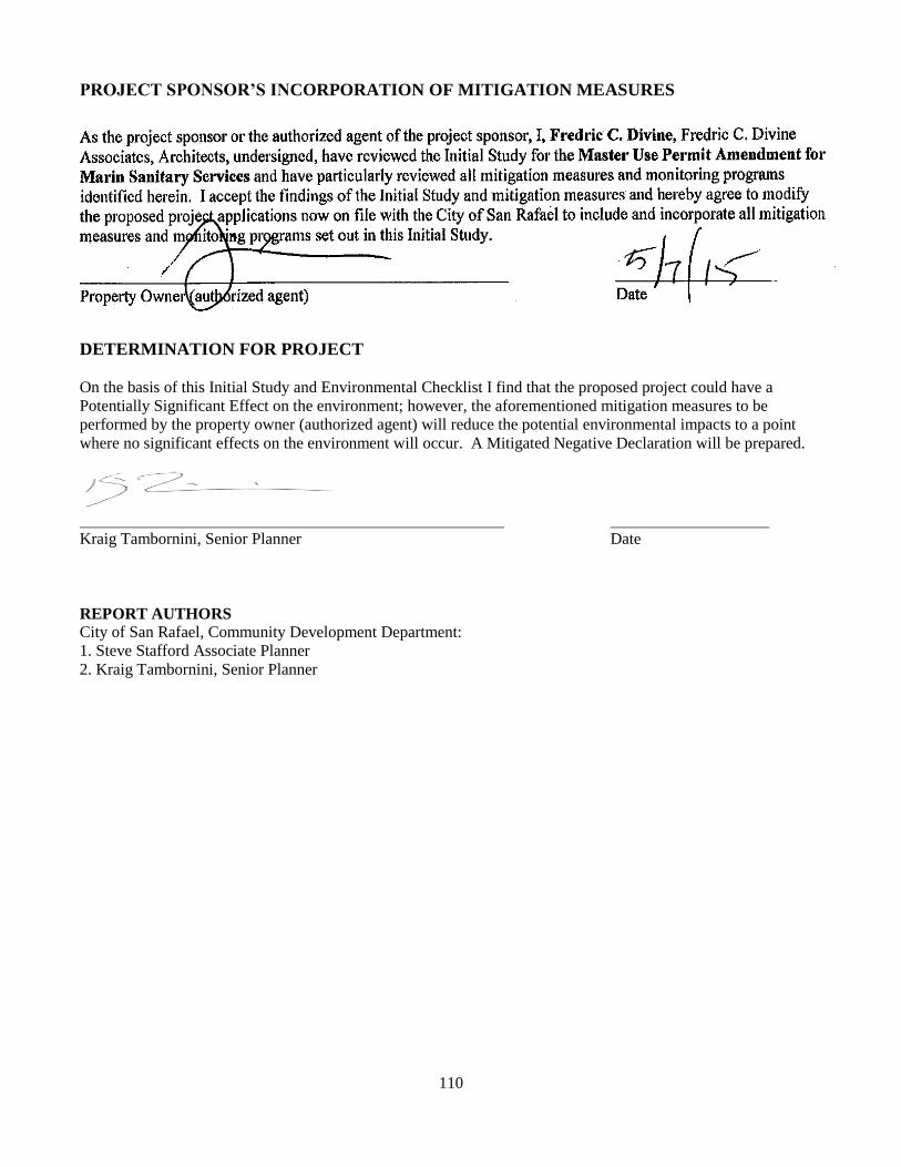
110
PROJECT SPONSOR’S INCORPORATION OF MITIGATION MEASURES
DETERMINATION FOR PROJECT
On the basis of this Initial Study and Environmental Checklist I find that the proposed project could have a
Potentially Significant Effect on the environment; however, the aforementioned mitigation measures to be
performed by the property owner (authorized agent) will reduce the potential environmental impacts to a point
where no significant effects on the environment will occur. A Mitigated Negative Declaration will be prepared.
Kraig Tambornini, Senior Planner Date
REPORT AUTHORS
City of San Rafael, Community Development Department:
1. Steve Stafford Associate Planner
2. Kraig Tambornini, Senior Planner