Embed Size (px)
Citation preview

Innovative Image Processing Innovative Image Processing Solutions from OVERWATCH Solutions from OVERWATCH GeoOpsGeoOps
April, 2008April, 2008
2008 ASPRS LIDAR PANEL2008 ASPRS LIDAR PANEL

OVERWATCH Geospatial Operations
Overwatch Geospatial Operations - HeritageOverwatch Geospatial Operations - HeritageOverwatch Geospatial Operations - HeritageOverwatch Geospatial Operations - Heritage

OVERWATCH Geospatial Operations
Industry Leading COTS ProductsIndustry Leading COTS ProductsIndustry Leading COTS ProductsIndustry Leading COTS Products
ELT 5500/3500 Feature Analyst
LIDAR Analyst
RemoteView
Urban Analyst InterSCOPE
Extraction of 3D features from LIDAR data Advanced 3D Exploitation and Analysis Geospatial Decision Support Platform
Image Processing, Exploitation, and Analysis Extraction of 2D/3D features from RasterImage Exploitation and Analysis

OVERWATCH Geospatial Operations
0verwatch Geospatial Solutions0verwatch Geospatial Solutions0verwatch Geospatial Solutions0verwatch Geospatial Solutions

OVERWATCH Geospatial Operations
Geospatial Analyst Suite™Geospatial Analyst Suite™Geospatial Analyst Suite™Geospatial Analyst Suite™

OVERWATCH Geospatial Operations
• Ability to work with Point Clouds, ASCII, Shapefiles, and DEM Raster Data.
• Ability to covert ASCII/ Text and Shapefiles to .LAS format
• Ability to quickly generate and modify DEM’s (bare-earth)
• Process data in a variety of map units
• Ability to collect buildings, trees and forest
• Classify LAS data• Generate variety of analysis
layers• Extract multi-component and
complex building features• Advanced building edit tools
LIDAR Analyst Key FeaturesLIDAR Analyst Key Features

OVERWATCH Geospatial Operations
1. Review Data
2. Convert LAS to DEM
3. Extract Bare-Earth
4. Refine Bare-Earth
5. Extract Buildings
6. Refine Buildings
7. Extract Vegetation
8. Generate Contours
9. Classify Point Cloud
10. Visualize in 3D
11. Analyze and output to other data formats
PROJECT WORKFLOWPROJECT WORKFLOW

OVERWATCH Geospatial Operations
1. Bare earth extraction anomaly.
2. Addition of bare earth points.
3. Last Return LIDAR shows building
4. Modified bare earth
Bare Earth ModificationsBare Earth Modifications

OVERWATCH Geospatial Operations
Know Your ResolutionKnow Your ResolutionKnow Your ResolutionKnow Your Resolution
Low Resolution – 3
foot

OVERWATCH Geospatial Operations
Know Your ResolutionKnow Your ResolutionKnow Your ResolutionKnow Your Resolution

OVERWATCH Geospatial Operations
Know Your ResolutionKnow Your ResolutionKnow Your ResolutionKnow Your Resolution
High Resolution – ½ foot

OVERWATCH Geospatial Operations
LIDAR AnalystLIDAR Analyst®® cont. cont.LIDAR AnalystLIDAR Analyst®® cont. cont.Accuracy*• Bare – earth:
– RMSE as low as 0.12 meters under leaf off conditions• Buildings:
– An overall accuracy as high as 97.4 percent
Speed*• Bare – earth:
– Average processing speed of 86 seconds per km2
• Buildings:– 11,000 buildings in 9 minutes over an Urban High Density
Area of 33 sq km (Los Angles East)
• Trees:– 100,000 trees were extracted from a Forested Semi-Rural Area
in 6 minutes over a 50 sq km extent (Stafford, CT )
* Done with the U.S Army’s Engineering and Research Development Center (ERDC) Topographic Engineering Center (TEC)
* Ground control data provided by ERDC-TEC

OVERWATCH Geospatial Operations
• Major improvements to automated 3D
building extraction algorithm
• Enhanced the automated collection of
complex 3D rooflines
• Improved building square-up
algorithm
3D Rooftop Modeling3D Rooftop Modeling

OVERWATCH Geospatial Operations
Auto-split Buildings
Courtyard Tool
Advanced 3D Editing ToolsAdvanced 3D Editing Tools
OVERWATCH Geospatial Operations
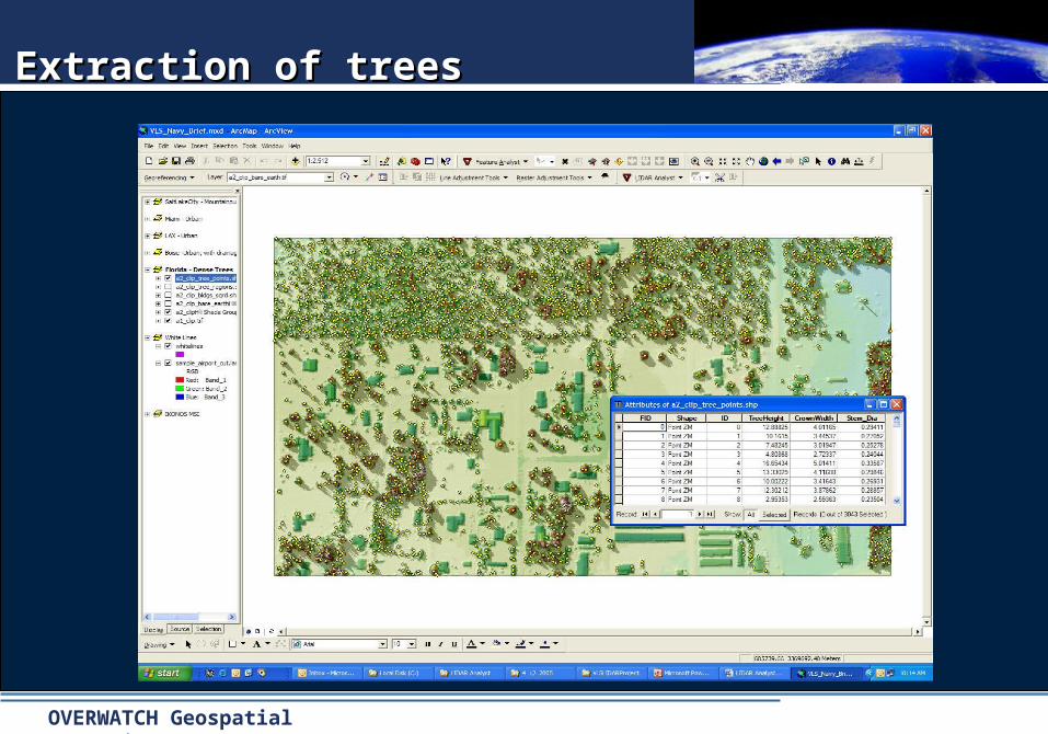
Extraction of treesExtraction of trees

OVERWATCH Geospatial Operations
• Automatically extract contour lines at user
specified intervals from a bare earth layer
• Output is 3D polyline shape file
Contour ExtractionContour Extraction

OVERWATCH Geospatial Operations
Overwatch Solutions Are Client TestedOverwatch Solutions Are Client TestedOverwatch Solutions Are Client TestedOverwatch Solutions Are Client Tested
Sample of Government Clients:
• NGA
• OSM
• All US Armed Forces Branches
• NOAA
• USGS
• US Forest Service
• Dept. of Homeland Security
• BLM
• Nat’l Parks Service
• Environment Canada
• Parks Canada
Sample of Government Clients:
• NGA
• OSM
• All US Armed Forces Branches
• NOAA
• USGS
• US Forest Service
• Dept. of Homeland Security
• BLM
• Nat’l Parks Service
• Environment Canada
• Parks Canada
Sample of Commercial Clients:
• Adams, Rehmann, Heggan,
& Associates Inc.
• Aramco Services Co
• Digital Globe
• Bechtel
• GeoSyntec Consultants
• Greenhorne and O'Mara
• Lockheed Martin
• NavTech
• Raytheon
• Sanborn
Sample of Commercial Clients:
• Adams, Rehmann, Heggan,
& Associates Inc.
• Aramco Services Co
• Digital Globe
• Bechtel
• GeoSyntec Consultants
• Greenhorne and O'Mara
• Lockheed Martin
• NavTech
• Raytheon
• Sanborn
Overwatch Overwatch software software resides on resides on over over 30,000+30,000+ workstations workstations world wide.world wide.
• Federal Federal
• StateState
• Local Local
• University University
• Non-profits.Non-profits.
OVERWATCH Geospatial Operations
QUESTIONS?QUESTIONS?
Overwatch Geospatial SolutionsOverwatch Geospatial SolutionsOverwatch Geospatial SolutionsOverwatch Geospatial Solutions

OVERWATCH Geospatial Operations
Contact Contact Overwatch Overwatch for more infofor more info
For more information please contact:
Rebecca Holman
406-829-1384x225
Overwatch Geospatial –
Montana Operations
P.O. Box 5012
Missoula, MT 59806
Free trial software is available at www.FeatureAnalyst.com
Free trial software is available at www.FeatureAnalyst.com