Embed Size (px)
Citation preview

1
INSPIRE:The European Spatial Data
Infrastructure 2009Max Craglia
on behalf of INSPIRE Team
Joint Research Centre – DG Environment – EUROSTAT

2
Outline
• Background to INSPIRE• Key components• Where are we now in developing them• Implementation in the Member States• INSPIRE as a process• Conclusion
3
Background to INSPIRE
• The environment!• …..as well as a lot of background discussions and research
activities leading up to INSPIRE in the 1990s.

4
Looking ahead
• Large degree of consensus that climate change, energy, water scarcity, and the impact of environment on health particularly in relation to air pollution and chemicals will continue to be the major issues in the next 20-30 years
• The global nature of phenomena and their interconnections will require more and more an integrated horizontal multi-sectoral approach to data analysis and modeling across the environmental and socio-economic domains, underpinned by relevant, timely, and global information systems
5
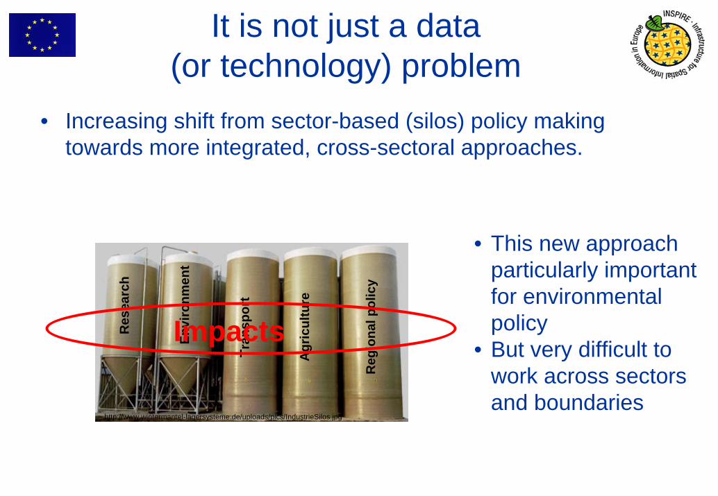
It is not just a data (or technology) problem
• Increasing shift from sector-based (silos) policy making towards more integrated, cross-sectoral approaches.
Tran
spor
t
Agr
icul
ture
Reg
iona
l pol
icy
Envi
ronm
ent
Res
earc
h
Impacts
• This new approach particularly important for environmental policy
• But very difficult to work across sectors and boundaries
http://www.wintermantel-lagersysteme.de/uploads/pics/IndustrieSilos.jpg

6
INSPIRE Process ( long one… -:) but needed !Bottom-up Stakeholder Involvement
– Building consensus in expert groups• Orientation and Position papers of experts • Establishing the state-of-play
– Preparing the proposal -> A Framework Directive• Scoping policy measures with expert advice• Assessing the political and socio-economic impact• A public review of the proposed measures
– Adoption of the Framework Directive by the Commission– The proposal on the political agenda of the EU Presidency– Co-Decision Procedure by Council and Parliament– Adoption of the Framework Directive– Transposing the Framework Directive– Sharing data and implementing the infrastructure
2001
2002
2003
2004
2004-7
2007-09
2009-16
7
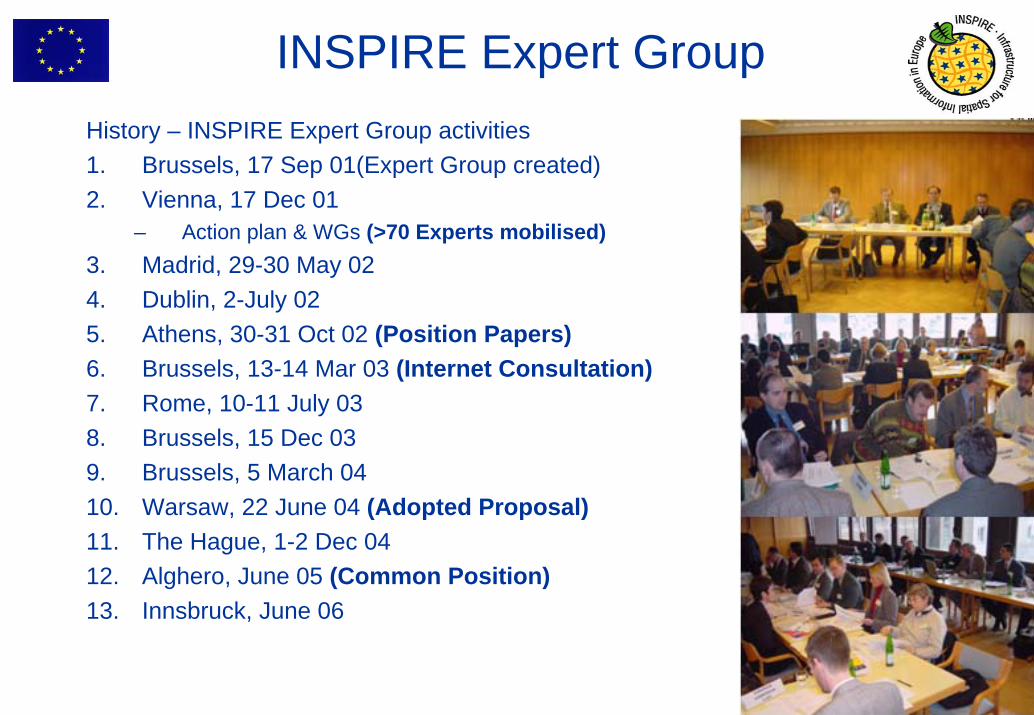
History – INSPIRE Expert Group activities1. Brussels, 17 Sep 01(Expert Group created)2. Vienna, 17 Dec 01
– Action plan & WGs (>70 Experts mobilised) 3. Madrid, 29-30 May 024. Dublin, 2-July 02 5. Athens, 30-31 Oct 02 (Position Papers)6. Brussels, 13-14 Mar 03 (Internet Consultation)7. Rome, 10-11 July 038. Brussels, 15 Dec 039. Brussels, 5 March 0410. Warsaw, 22 June 04 (Adopted Proposal)11. The Hague, 1-2 Dec 0412. Alghero, June 05 (Common Position)13. Innsbruck, June 06
INSPIRE Expert Group

8
INSPIRE principles
• Data should be collected once and maintained at the level where this can be done most effectively
• Combine seamlessly spatial data from different sources and share it between many users and applications (the concept of interoperability)
• Spatial data should be collected at one level of government and shared between all levels
• Spatial data needed for good governance should be available on conditions that are not restricting its extensive use
• It should be easy to discover which spatial data is available, to evaluate its fitness for purpose and to know which conditions apply for its use
9
• INSPIRE lays down general rules to establish an infrastructure for spatial information in Europe for the purposes of Community environmental policies and policies or activities which may have an impact on the environment.
• INSPIRE to be based on the infrastructures for spatial information established and operated by the Member States.
• INSPIRE does not require collection of new spatial data • INSPIRE does not affect existing Intellectual Property Rights
INSPIRE general provisions

10
INSPIRE components
• Metadata
• Interoperability of spatial data sets and services
• Network services (discovery, view, download, transform, invoke)
• Data and Service sharing (policy )• Coordination and measures for Monitoring & Reporting
• INSPIRE is a Framework Directive• Detailed technical provisions for the issues above will be laid
down in Implementing Rules (IR)
11
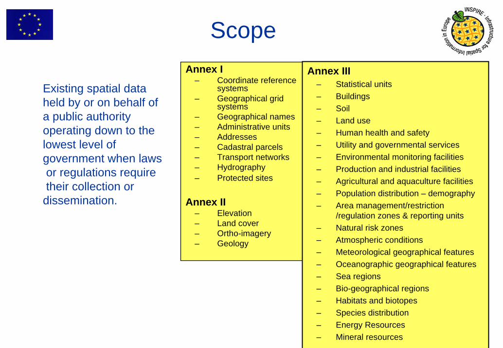
Scope
Existing spatial dataheld by or on behalf ofa public authority operating down to the lowest level of government when lawsor regulations requiretheir collection or dissemination.
Annex I– Coordinate reference
systems– Geographical grid
systems– Geographical names– Administrative units– Addresses– Cadastral parcels– Transport networks– Hydrography– Protected sites
Annex II– Elevation– Land cover– Ortho-imagery– Geology
Annex III– Statistical units– Buildings– Soil– Land use– Human health and safety– Utility and governmental services– Environmental monitoring facilities– Production and industrial facilities– Agricultural and aquaculture facilities– Population distribution – demography– Area management/restriction
/regulation zones & reporting units– Natural risk zones– Atmospheric conditions– Meteorological geographical features– Oceanographic geographical features– Sea regions– Bio-geographical regions– Habitats and biotopes– Species distribution– Energy Resources– Mineral resources

12
Where are we now
• Metadata • Network services• Interoperability of spatial data sets and services• Initial operating capability and GeoPortal

13
Metadata
• INSPIRE Metadata Regulation published 4th December 2008• Two years for Member States to create metadata for Annex I and II, 5
years for Annex III. • Long process to find the balance between “as little as possible” and “as
much as necessary”• Separation between legal text (what needs doing) from non-binding
Guidelines explaining How to do. Flexibility in the face of evolving standards and practices.
• Maintenance of Technical Guidelines based on user feedback • Metadata editor publicly available as part of prototype INSPIRE geo-portal
• to test that IRs and Guidelines are technically coherent and compliant with ISO standards
• to support MS in creating metadata compliant with regulation• plan to assess the need for a Multilingual Open Source version so
that it can be downloaded by users and extended by thematic communities

14
Discovery and View services
• Draft regulation adopted by INSPIRE Committee in December 2008.
• European Parliament scrutiny during the summer, expected adoption end of the year
• Key features: – Key building block of any SDI. Important to make an assessment of
resources available.– supporting both European and international Coordinate Reference
Systems.• Additional technical reports:
– INSPIRE SOAP primer for INSPIRE Discovery and View Services (see INSPIRE web site)
– Public availability of the new version of technical guidance documents in June 2009

15
Download and Transformation Services
• Review by stakeholders completed, comments being addressed
• Draft Regulation prepared by the Commission in the second half of September
• Submission to the INSPIRE Committee in December • Main features: providing access to harmonised data either
directly or via services able to transform the data models from the national ones to the INSPIRE ones.
• Interoperability through services in practice.
16
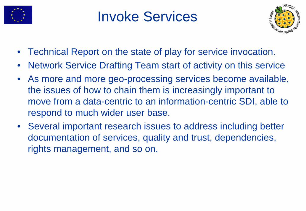
Invoke Services
• Technical Report on the state of play for service invocation.• Network Service Drafting Team start of activity on this service• As more and more geo-processing services become available,
the issues of how to chain them is increasingly important to move from a data-centric to an information-centric SDI, able to respond to much wider user base.
• Several important research issues to address including better documentation of services, quality and trust, dependencies, rights management, and so on.

17
Interoperability of spatial data sets and services
• Development of these Implementing Rules follow a three-step approach:1. Development of conceptual framework and specification
methodology (by Data Specification Drafting Team)2. Development of data specifications for each spatial data
theme (by different Thematic Working Groups) 3. Preparation of the Implementing Rules based on data
specifications (by the Commission)

18
Data specification development

19
Needs seamless access to
Any user e.g.:
• European Institutions
• Emergency in cross-borders
The Outcome and Scope ofINSPIRE DS
Mechanisms for sharing and exchangeMechanisms for sharing and exchange
(This is a very generic diagram!)
INSPIRE Implementation Rules
(e.g. Data Specifications)
Member States Data
(e.g. Addresses)
20
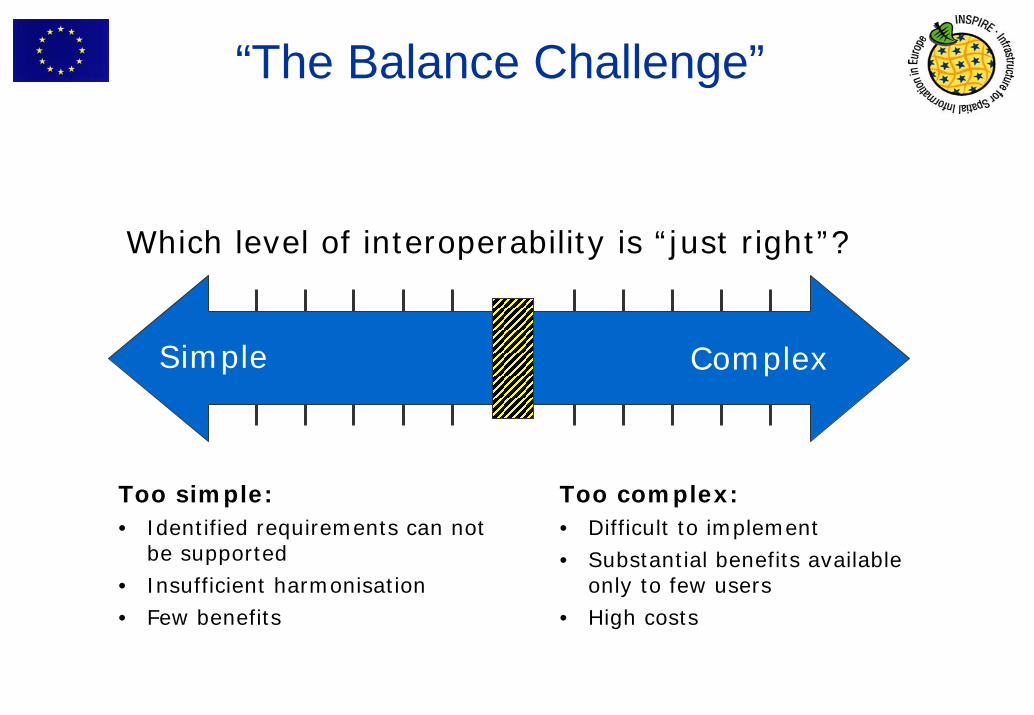
“The Balance Challenge”
Which level of interoperability is “just right”?
Simple Complex
Too simple:• Identified requirements can not
be supported• Insufficient harmonisation• Few benefits
Too complex:• Difficult to implement• Substantial benefits available
only to few users• High costs

21
Status
Eight Thematic Working Groups• Kick-off meeting in February 2008• Data specifications for Themes of Annex I in November 2008
based on user requirements, reference material, and relevant use cases
Consultation and Testing• Consultation draft guidelines and draft structure and contents
of Implementing Rules Annex I completed, including testing by stakeholders
• Proposed regulation to be submitted to INSPIRE Committee in December
• For more details see Session 4.6 and 5.6 on Thursday

22
Interoperability of spatial data sets and services – Annex II, III
• Process for Annex II, III - Principles:– Open, participatory and transparent process– Involvement of stakeholders and relevant thematic experts
and communities at all steps– Increasing importance of projects for development and
testing of data specifications– Submission of candidate specifications is important. They
will need to be evaluated by the community and adjusted to be coherent with data specifications of Annex I, and the Generic Conceptual Model as well as being coherent across themes.
– Experiences learnt from Annex I taken into account

23
Data and Service Sharing between Member States and CIB
• The INSPIRE Directive requires Member States to adopt measures for the sharing of data and services between public authorities for public tasks relating to the environment without restrictions occurring at the point of use. Such measures are open to international bodies and Community institutions and bodies
• Public authorities may charge, license each other and Community institutions provided this does not create an obstacle to sharing.
• When spatial data or services are provided to Community institutions for reporting obligations under Community law relating to the environment then this will not be subject to charging.
• Member States shall provide the institutions and bodies of the Community with access to spatial data sets and services in accordance with harmonised conditions.
• The regulation on these harmonised conditions has now been approved by the INSPIRE Committee and will go through the review by the European Parliament. Best practice and guidelines allow to identify measures that are successful in ensuring and maintaining quality of data as well as increasing access and use

24
Monitoring and Reporting
• Monitoring and Reporting IR approved by INSPIRE Committee in December 2008, published in OJ 11th June 2009.
• Quantitative indicators on the progress of the SDI in the member states and qualitative reports about implementation experiences and benefits will enrich our collective knowledge in SDI assessment.
• For more details see Session 2.6 this afternoon

25
Initial Operating CapabilityTask Force
In Network services regulation introduced the concept of IOC i.eservices provide full functionality but not required yet full quality of service.
Task Force created to manage this process. Purpose– to help and support the implementation of INSPIRE in the Member
States Scope– architectural aspects and implementation of Network Services to
ensure interoperability with the INSPIRE geoportal and among Member States
Focus– implementation of the INSPIRE Discovery and View Services.
Composition– representatives, from all Member States, responsible for the
architecture design and the service implementation of the National SDIs.

26
INSPIRE Geoportal
http://www.inspirehttp://www.inspire--geoportal.eugeoportal.eu

27
• Current focus on– INSPIRE Discovery & View services, metadata– Tools (metadata editor, multilinguality, …)
• Technical aspects addressed:– Access to distributed INSPIRE Network Services– Performance, Quality of service– Multilingual support (GEMET, translators, …)
• Discovery & view web clients based on open source S/W and internal development– Support the draft Technical guidelines (OGC CSW ISO AP, ISO
19128)• Based on the prototype geoportal, specifications for the operational portal
will be drafted. Public procurement expected end- 2011• Operational infrastructure subject to the availability and testing of MS
INSPIRE network services• More information this afternoon at 16.00hrs
State of Progress

28
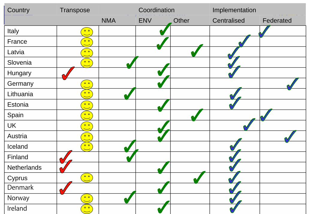
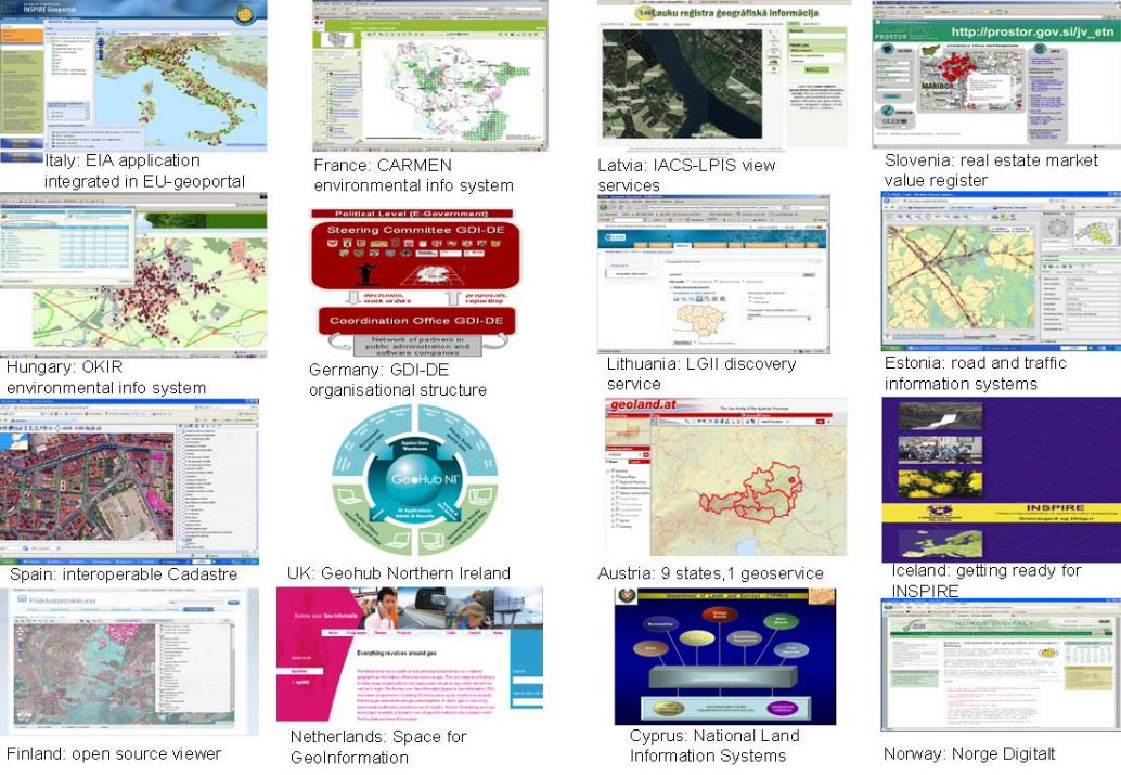
Implementing INSPIRE in the Member States
• Request to Member State to provide some information for this presentation on:– Status of transposition into national legislation– Who is responsible for coordination– Features of the implementation strategy e.g. centralised or
decentralised • 18 Countries responded within 1 week, we are grateful for
their contribution
29
OverviewCountry Transpose Coordination ImplementationNMA ENV Other Centralised Federated
ItalyFranceLatviaSloveniaHungaryGermanyLithuaniaEstoniaSpainUKAustriaIcelandFinlandNetherlandsCyprusDenmarkNorwayIreland
30

31
To know more

32
Examples of impacts
• It is soon to get INSPIRE impact evidence, but it is clear that INSPIRE brought a huge dynamism and stress business model considerations in France.
• In Iceland there is a need to develop a NSDI. .. By making a introduction on the benefits of INSPIRE there is already a positive impact happening between governmental institutes.
• Key benefits of INSPIRE in Lithuania: all state and local authorities will be following common standards and requirements maintaining spatial data + wider use and higher quality of state data and process control
• The implementation of INSPIRE in Cyprus is expected to play a very important role in the every day activities of all government departments using spatial information.. local authorities, utilities, education, and the private sector.

33
Examples of impacts
Identified Benefits to Date in EIRE, following consultations• Supporting an improved evidence base for public policy making• Supporting monitoring of public policy implementation and impacts• Facilitating ‘joined up government’• Facilitating better targeted service provision and more effective use of
public resources• Facilitating more robust evidence-based research, spatial analysis and
modelling• Facilitating environmental protection• Supporting a more competitive economy• Demonstrating openness with data held by public bodies• Facilitating a more informed general public

34
• INSPIRE has fostered the development of advanced SDIs also at the sub-national level
• Evidence from Catalonia and Lombardia indicates that costs of setting up and maintaining regional SDI can be recovered in less than 2 years, with real benefits to citizens, business and public administration
• For more info see Session 4.2
Examples of impacts

35
INSPIRE as a process
• Open and transparent approach in:– Formulating the policy (Experts from Member States writing
position papers as input)– Assessing likely impact (Expert from MS preparing
Extended Impact Assessment, chaired by EA for England and Wales)
– Advising on process (INSPIRE Expert Group with representatives MS)
– Mobilizing stakeholder through open registration of Spatial Data Interest Communities and Legally Mandated Organisations
– Providing input to drafting of Implementing Rules through experts, reference material, and projects
– Commenting on Drafts, and testing

36
Building the community

37
Building the spirit

38
Contribution of INSPIRE to international SDI development
• INSPIRE’s architectural approach is suitable for multi-country situations in which SDIs already exist in some form
• Fostering a shared approach to international environmental challenges.
• Adding to the pool of knowledge on assessment of socio-economic impacts of SDIs
• Multilingual approach is both a challenge and opportunity• Best practice and technical guidance documents • Contributing to revision and development of standard based
on real-life implementations

39
Conclusions
• INSPIRE is an interesting model for developing not only a technological infrastructure, but also shared practices and working methods, thorough collaboration and partnership.
• It takes (a lot) of time and effort but it is well worth it to achieve a shared sense of ownership of both process and outcomes.

40
Thank you for your attention !
http://www.echttp://www.ec--gis.org/inspiregis.org/inspire//
[email protected]@jrc.cec.eu.int