Embed Size (px)
DESCRIPTION
Install and Use Analysis Manager to create Decision Trees. 과 목 Data Mining 교 수 용 환 승 작성자 김지영. 목 차. Data Process Result. 1. Data. http://kdd.ics.uci.edu/ - Cover Type - PowerPoint PPT Presentation
Citation preview

2003_12 1
Install and Use Analysis Manager to create Decision Trees
과 목 Data Mining
교 수 용 환 승
작성자 김지영

2003_12 2
목 차
Data
Process
Result
2003_12 3
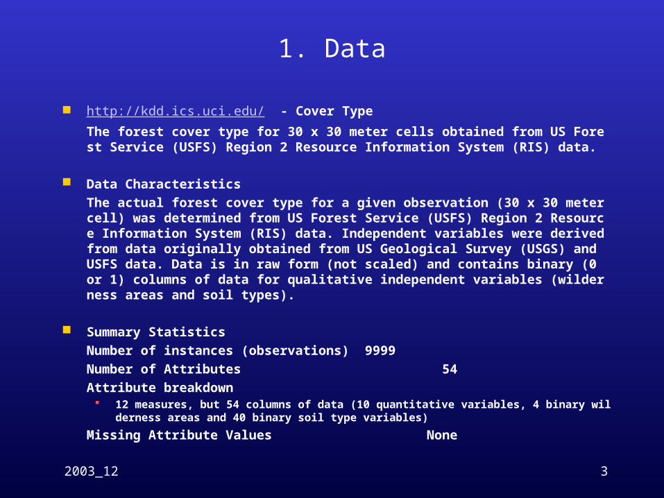
1. Data
http://kdd.ics.uci.edu/ - Cover Type The forest cover type for 30 x 30 meter cells obtained from US Forest Service (USFS) Region 2 Resource Information System (RIS) data.
Data CharacteristicsThe actual forest cover type for a given observation (30 x 30 meter cell) was determined from US Forest Service (USFS) Region 2 Resource Information System (RIS) data. Independent variables were derived from data originally obtained from US Geological Survey (USGS) and USFS data. Data is in raw form (not scaled) and contains binary (0 or 1) columns of data for qualitative independent variables (wilderness areas and soil types).
Summary StatisticsNumber of instances (observations) 9999Number of Attributes 54Attribute breakdown
12 measures, but 54 columns of data (10 quantitative variables, 4 binary wilderness areas and 40 binary soil type variables)
Missing Attribute Values None

2003_12 4
1. Data
Variable Information
Original Name Colunm Name Data Type Measurement Description
seq seq integer Unique KeyElevation Elevation quantitative meters Elevation in meters
Aspect Aspect quantitative azimuth Aspect in degrees azimuth
Slope Slope quantitative degrees Slope in degrees
Horizontal_Distance_To_Hydrology Hor_Dist_To_Hydro quantitative meters Horz Dist to nearest surface water features
Vertical_Distance_To_Hydrology Ver_Dist_To_Hydro quantitative meters Vert Dist to nearest surface water features
Horizontal_Distance_To_Roadways Hor_Dist_To_Road quantitative meters Horz Dist to nearest roadway
Hillshade_9am Hillshade_9am quantitative 0 to 255 index Hillshade index at 9am, summer solstice
Hillshade_Noon Hillshade_Noon quantitative 0 to 255 index Hillshade index at noon, summer soltice
Hillshade_3pm Hillshade_3pm quantitative 0 to 255 index Hillshade index at 3pm, summer solstice
Horizontal_Distance_To_Fire_Points Hor_Dist_To_FP quantitative meters Horz Dist to nearest wildfire ignition points
Wilderness_Area (4 binary columns) Wilder ( * 4) quantitative 0 (absence) or 1 (presence) Wilderness area designation
Soil_Type (40 binary columns) Soil ( * 40) quantitative 0 (absence) or 1 (presence) Soil Type designation
Cover_Type (7 types) Cover integer 1 to 7 Forest Cover Type designation
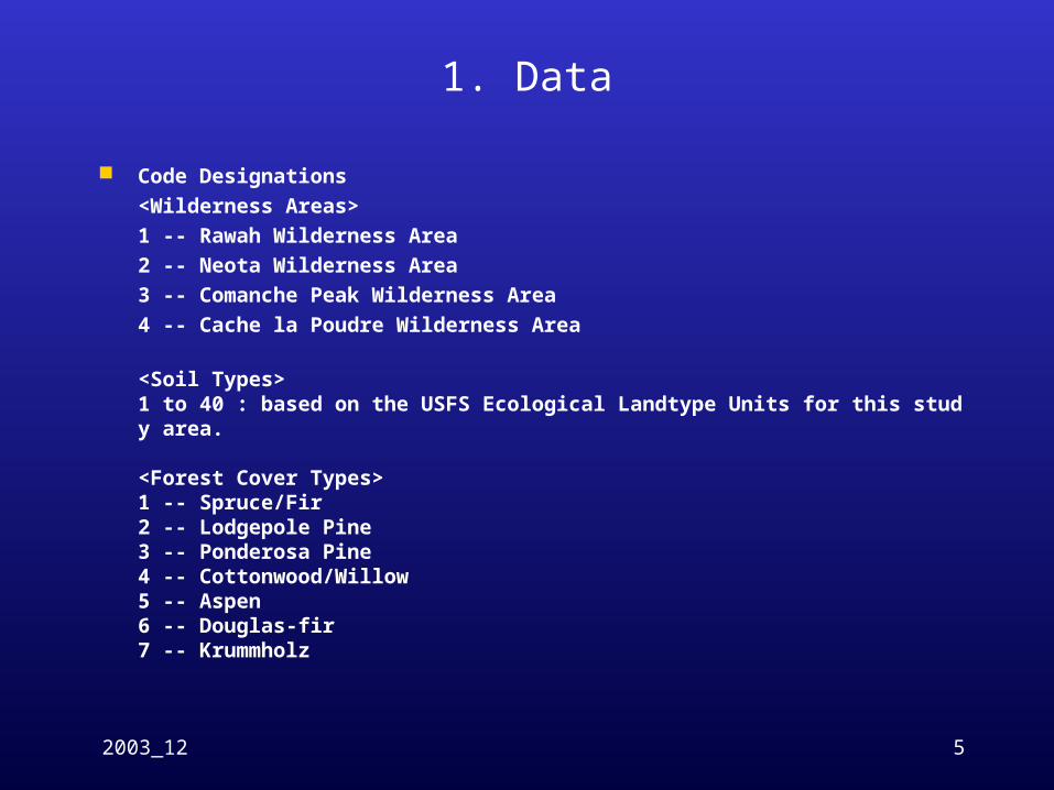
2003_12 5
1. Data
Code Designations<Wilderness Areas>1 -- Rawah Wilderness Area 2 -- Neota Wilderness Area 3 -- Comanche Peak Wilderness Area 4 -- Cache la Poudre Wilderness Area
<Soil Types>1 to 40 : based on the USFS Ecological Landtype Units for this study area.
<Forest Cover Types>1 -- Spruce/Fir 2 -- Lodgepole Pine 3 -- Ponderosa Pine 4 -- Cottonwood/Willow 5 -- Aspen 6 -- Douglas-fir 7 -- Krummholz

2003_12 6
1. Data
Class Distribution
Number of records of Spruce-Fir: 1375 Number of records of Lodgepole Pine: 1462Number of records of Ponderosa Pine: 1262 Number of records of Cottonwood/Willow: 1620Number of records of Aspen: 1582 Number of records of Douglas-fir: 1349 Number of records of Krummholz: 1349 Number of records of other: 0
Total records: 9999

2003_12 7
2. Process Import 2 Tables
<Attr> Seq 와 53 개의 Measure Attribute
<Covtype>Seq 와 Predict 값인 cover
2003_12 8
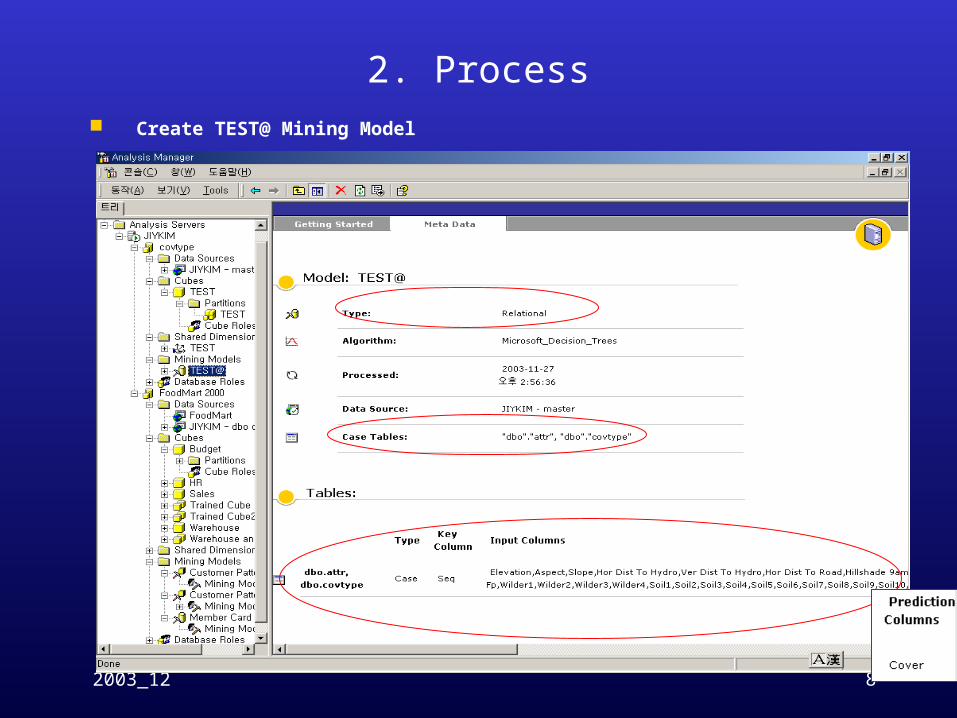
2. Process Create TEST@ Mining Model

2003_12 9
3. Result Node Path: All
2003_12 10
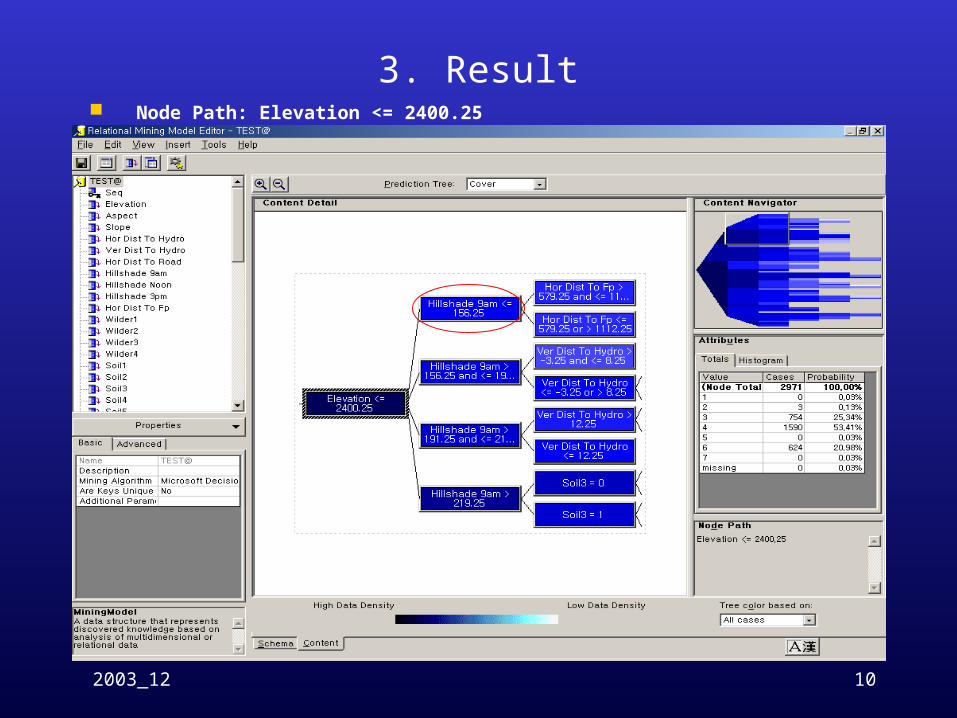
3. Result Node Path: Elevation <= 2400.25
2003_12 11
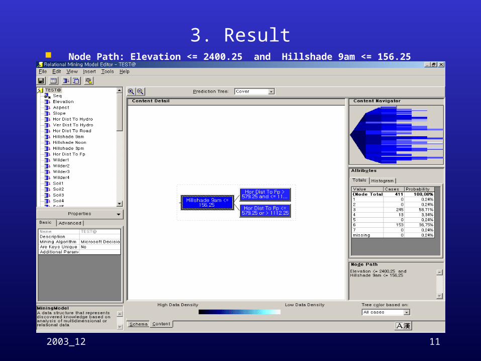
3. Result Node Path: Elevation <= 2400.25 and Hillshade 9am <= 156.25

2003_12 12
3. Result Node Path: Elevation <= 2400.25 and Hillshade 9am <= 156.25 and Hor Dist To Fp > 57
9.25 and <= 1112.25

2003_12 13
3. Result Node Path: Elevation <= 2400.25 and Hillshade 9am <= 156.25 and Hor Dist To Fp <= 5
79.25 or > 1112.25
2003_12 14
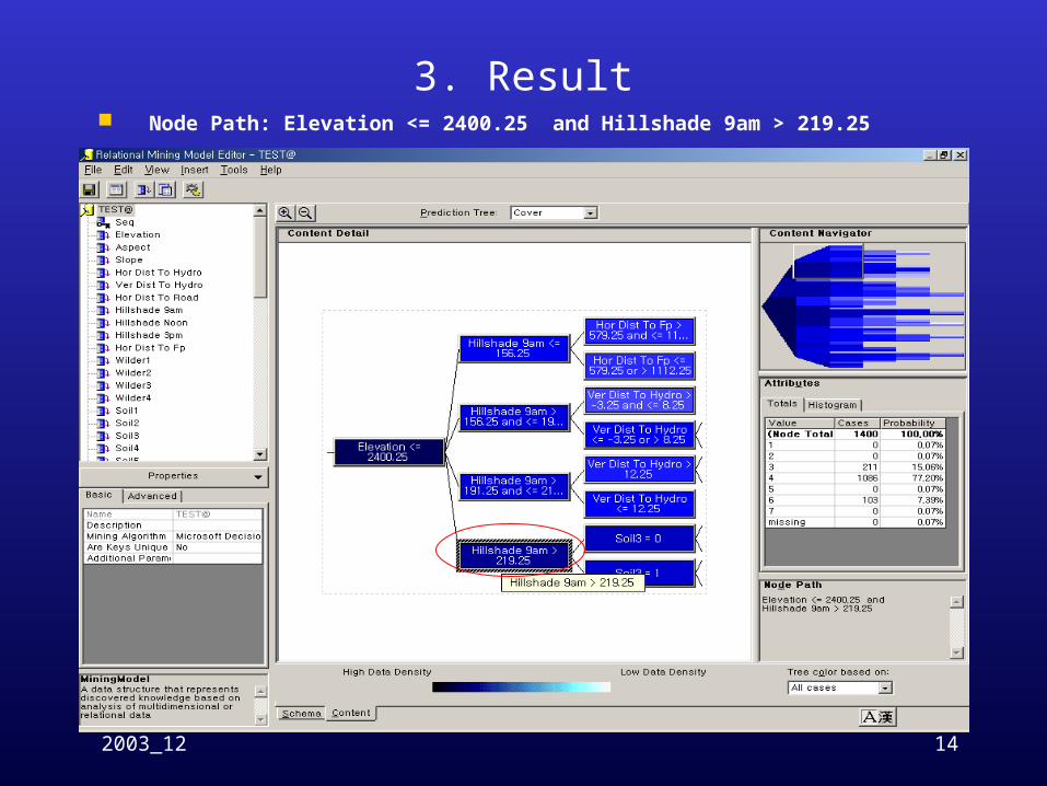
3. Result Node Path: Elevation <= 2400.25 and Hillshade 9am > 219.25

2003_12 15
3. Result Node Path: Elevation <= 2400.25 and Hillshade 9am > 219.25

2003_12 16
3. Result Node Path: Elevation <= 2400.25 and Hillshade 9am > 219.25 and Soil3 = 0

2003_12 17
3. Result Node Path: Elevation <= 2400.25 and Ver Dist To Hydro <= 1.75 or > 131.25 and Hillsha
de 9am > 219.25 and Soil3 = 0
2003_12 18
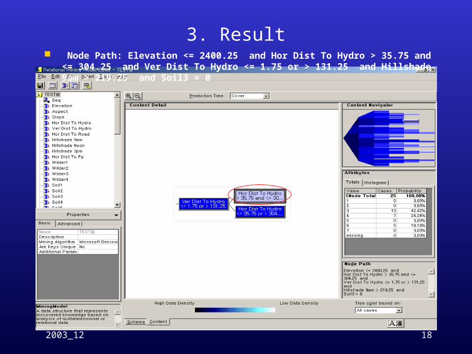
3. Result Node Path: Elevation <= 2400.25 and Hor Dist To Hydro > 35.75 and <= 304.25 and Ver
Dist To Hydro <= 1.75 or > 131.25 and Hillshade 9am > 219.25 and Soil3 = 0
2003_12 19
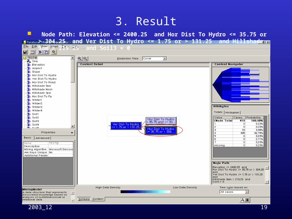
3. Result Node Path: Elevation <= 2400.25 and Hor Dist To Hydro <= 35.75 or > 304.25 and Ver Di
st To Hydro <= 1.75 or > 131.25 and Hillshade 9am > 219.25 and Soil3 = 0

2003_12 20
3. Result Dependency Network Browse

2003_12 21
3. Result Dependency Network Browse