Embed Size (px)
Citation preview

Institute of Geodesy and Cartography REMOTE SENSING CENTER - experiences in Earth
Observation in FPs - towards Horizon 2020
www.igik.edu.pl Katarzyna Dabrowska-Zielinska,
Institute of Geodesy and Cartography, research centre,
Poland [email protected]
Tel: +48 22 329 19 74; fax: +48 22 329 19 50

Folie 2 NKS Raumfahrt, Dr. Adrian klein
2
Topics ThaT we are inTeresTed in:
EO applications
Land use Land use change - change of biodiversity indicators
Use of Copernicus Sentinel Data Data fusion – optical and microwave data Data fusion from several Sentinels satellites Copernicus data to GEOSS
Reprocessing and calibration of space-based data Land and Climate change monitoring for global, regional and local scale
Exchange of Mass, Energy and Water between the Surface and the Atmosphere
Changes of biomass – forests, grasslands, agricultural areas Agriculture – changes in crop, soil moisture and phenology Monitoring of climatge change: CO2 balance, vegetation phenology, Energy
and Water Balance Natural hazards: droughts – temperature extremes, fires, floods,
Technological development

Participation in FP5, FP6, FP7 EU Projects Geoland, Geoland2 CEUBIOM, INTAS, MONINA, GIONET , NEREUS, Participation in ESA Projects: AO, CAT1; 2 ; PECS – „Carbon Balance in different ecosystems” „Nitrogen Polution of Water” - Modelling, Development of new Methodologies for: Land Cover ; Land Cover Change Mapping Crop Yield Prognosis ; Crop Structure and Soil Moisture in the root zone Modelling Processing of Multisource Satellite Data: •High and Very High optical data •Medium Resolution optical data, Terra MODIS •Low resolution (NOAA satellite Station in IGIK); Terra MODIS •Radar images – Envisat ASAR, Terra SAR-X; ALOS1; ALOS2
Folie 4
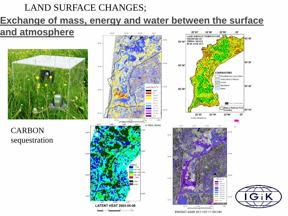
Exchange of mass, energy and water between the surface and atmosphere
NKS Raumfahrt, Dr. Adrian klein
4
LAND SURFACE CHANGES;
CARBON sequestration

Folie 5 NKS Raumfahrt, Dr. Adrian klein
5
Presentation of the organisation Facilities: NOAA receiving station; Computer Laboratory; GROUND MEASUREMENTS: instruments to measure various biophysical parameters in the field (EXOTECH, LAI-2000 Plant Canopy Analyser, AccuPAR, Infrared Thermometer, Trime-FM, chlorophyll content meter); soil CO2 Chamber Flux System; CAMPBELL meteorological station.
Ground Equipment Colaboration with international partners: ESA, ASTRIUM, FAO, NOAA, CCRS, JRC, EEA, AGILE, Joanneum Research, GEONARDO Environmental Technologies Ltd, Leicester University
Winter wheat prognosis based on BioPar data
CROP PROGNOSIS – VEGETATION CONDITIONS (AVHRR , MODIS)
Winter Freezing Conditions

Folie 6
COPERNICUS – SENTINEL DATA – Data Fusion optical and microwave
ENVISAT - MERIS ENVISAT - ASAR

Folie 7 NKS Raumfahrt, Dr. Adrian klein
LAND USE LAND USE Change (LULUC) – Space – based Data Change in Biomass
Change in Protected Areas – NATURA 2