Embed Size (px)
Citation preview

Annual Report on IWP sponsored Project
Integrated Development and Management Plan
for Water Resources of the
Wainganga Sub- Basin (Godavari), Maharashtra
Submitted to India Water Partnership
2011

ACKNOWLEDGEMENTS
The work being undertaken for Preparing a Master Plan for the Integrated Development and Management of Water Resources in the Wainganga River Bain is supported by the several workshops and consultations with local communities, researchers, government officials and representative NGOs in the districts of Bhandara, Gondia, Gadchiroli, Nagpur and Chandrapur in Maharashtra State. The consultations and data collection was funded by the India Water Partnership, New Delhi, which is a constituent of Global Water Partnership, Stockholm. Gmoukh Environmental Trust for Sustainable Development (Convenor, West Zone Water Partnership) acknowledges with thanks the contribution of the India Water Partnerships for making possible preparation of this document through the financial assistance. We are grateful also to the timely support provided by Prof. S R Hashim, President and Dr. Veena Khanduri, Executive Secretary, India Water Partnership.
We would like to acknowledge the participants from the scientific community, and government and non government organizations for actively participating in the deliberations, and providing their valuable suggestions in the planning process. We are especially grateful to the local communities who have not only shared their traditional knowledge and understanding with us, but also gave a new perspective to the work that we have undertaken.
We would like to take this opportunity to thank the various organizations in the Wainganga Region, especially Bhandara Nisarga Va Sanskruti Abhyas Mandal for providing us support during the extensive consultation work which involved traveling to remote areas and villages. Vijay Paranjpye Chairman, Gomukh Environmental Trust for Sustainable Development Convenor, West Zone Water Partnership 92/2, Durga, Gangote Path, Nr. Kamala Nehru Park, Erandawane, Pune 411004 +91-99220-09749

Gomukh Environmental Trust for Sustainable Development
Convenor, West Zone Partner Partnership INDIA WATER PARTNERSHIP (IWP)
Annual Report 2011
Gomukh Trust submitted an Inception Report for undertaking the Integrated Water Resources Development and Management Planning Project in October 2010 which was reviewed and accepted by the Water Resources Department, Government of Maharashtra in January 2011. As the second phase of the Project, efforts were directed in preparing the ‘Project Identification Report’ (PIR) for the Wainganga Basin. The PIR was aimed at identifying and prioritizing the key projects that could be implemented by the State Government in order to resolve the pressing developmental problems in the Wainganga Basin. During the year we tried to maintain two distinct tracks in order to complete the Project Identification Report, which were supported by the India Water Partnership.
The two tracks included:
1. Collection and Analysis of base data for planning purposes: In order to estimate the availability of water resources and in order to study and anticipate the current and future water requirements for developing and maintaining sustainable livelihoods in the Project region, we collected and analyzed secondary data available on the region. The domains on which data was collected include; a. Hydrology data: Twenty year data on rainfall, river gauges, full climate data (temperature, evaporation, humidity, wind direction and velocity) was collected and analyzed to derive water availability in the Project Area. b. Geographical data: 72 topological maps, with 1:50,000 scale that cover the project area were digitized with 37 layers with details such as administrative boundaries, towns and villages, historical sites, tourist places, rivers, streams, dams and reservoirs, canals, traditional water tanks and structures, watersheds, agricultural areas, forests, etc. Further, a map showing the flood-prone areas in the Project Area was also prepared. Through ground-truthing and stakeholder participation we have identified villages dependent on fisheries, forests, etc. c. Population data: The 1991, 2001 and provisional 2011 Census data was used to estimate the current and future demand for water. The water demand was classified and prioritized based

on demand for domestic water supply, agriculture, industries and elements such as demand for forests and fisheries were added. d. Infrastructural and Institutional Data: Water resources are linked with development of various domains including agriculture and industries. As per our assessment, agriculture is the primary source of livelihood in the region. Therefore, data on agriculture related infrastructural facilities such as markets and warehouse facilities, transport facilities, availability of irrigation pumps, drip irrigation facilities, etc. was collected and analyzed for sufficiency and distribution. Other water based infrastructural requirements such as hydropower, navigation etc. was also studied. e. Livelihood Data: Data was collected on the various livelihoods in the region including on agriculture, fisheries, forests and forest use rights, agro-industries, etc. In-depth stakeholder meetings were conducted to find ways for infrastructural and institutional support required for sustaining livelihoods. Although the aim was to complete data collection during the first quarter of the year, it was found that the estimated time was not enough to access Governmental documents and reports being made at regional levels. Therefore, the data collection was spread out to cover the entire year. We are still awaiting data on Groundwater, which forms a very important piece of our studies on water balance. The lack of data reduced the pace of work significantly; however we continued to conduct stakeholder consultations at various locations in the Project Area. 2. Establishing stakeholder network on various levels and ensuring participation in planning When we first began the Wainganga Planning Project, we had envisaged organizing three stakeholder meetings focused on certain issues such as Participatory Irrigation Management (or now on the law ‘Maharashtra Management of Irrigation Systems by Farmers Act, 2005), consultation of stakeholders with members of the Maharashtra Water Resources Regulatory Authority, and workshops for the formation of a River Basin Organization.
However on holding discussions with local civil society organizations and community representatives, we found that participation in the planning process would be more efficient if there were several small consultations with various stakeholder groups. Further based on the advice received from local CSOs, we realized that it would be important to form a strong community network prior to the formal establishment of a community based river basin organization or an area water partnership. Such a network formation would entail the identification of common grounds, priorities and action plans for establishing and directing an

area water partnership. During the year a network of CSOs and individuals was formed in the Kathani river basin (a tributary of Wainganga) and it would be formalized in January 2011.
Figure 1: Meeting of Stakeholders in Bhandara
Several small and large stakeholder consultations and discussion were held at local levels by our field staff, and many of these ideas were incorporated in the Project Identification Report. Ideas especially related to fisheries development such as maintenance of dohas (small water bodies formed in the river course during the lean months which support fisheries), recognizing riverine fisheries through formation of institutions and allocation of water, etc. were incorporated in the PIR.

Figure 2 Stakeholder meeting 13th June 2011
An important process has been initiated in the Wainganga basin due to the stakeholder consultation in December 2011. Mr. Ullhas Phadke, a member of the Abhyas Gats, has been asked to prepare a water literacy syllabus for the proposed University at Gadchiroli. The syllabus will cover not only under-graduate but also post-graduate and doctoral studies. The stakeholders have suggested that Wainganga River would become the focus of these studies and many activities were brainstormed for being included in the curricula. Some of them include principles of Integrated Water Resource Management, Integrated River Basin Management, household and institutional water audit and interrelationship between irrigation, fisheries, tourism and urban water supply. As part of ‘work experience’ it has been recommended that students would be taken to the river front tours from Seoni to Balaghat and then from Tumsar to Bhandara. Boats will be used wherever possible in order to expose the students to various aspects of water. A full-fledged course will eventually be developed for the proposed University.

Figure 3: Meeting with fisherman in Rengepar Village
Apart from this, Gomukh as a representative of the West Zone Water Partnership
continuously corresponded with the Mr. Suresh Sodal (Member Secretary, MWRRA) in order to strengthen the aspect of stakeholder participation in the ‘Guidelines’ for implementing the River Basin Organization concept in Maharashtra. We were informed that appropriate changes have been made by the MWRRA. Similarly, we have actively engaged with the MWRRA and sent oral and written comments related to determination of bulk water tariffs and smoother functioning of the activities of Water Users’ Associations.
The Wainganga River Basin has no major dam, and most irrigation canals are incomplete. Water Users’ Associations have as yet not been established in the region and we have urged the Water Resource Department that the processes should be accelerated in the region.

3. Development of materials on Climate change adaptation A comprehensive document on flood preparedness was prepared in order to adapt to Climate Change. Through the document we have identified 180 flood prone villages. Apart from this, zonal classification based on high flood line, dam break line, etc. has been prepared. Traditional strategies inclusive of efficient and integrated land and water use for sustainable use of water in agriculture with almost zero effluent discharge into rivers are currently being documented. We have ensured through the Project Identification Report that due emphasis is given for the development of community led forestry, pastures, etc. through water resource projects so that alternative livelihoods are available in case of untimely monsoons. Provisions

for village level power security in place of thermal and hydropower have been created so as to promote carbon efficient power generation. We developed a proposal for an in depth, three-year study on climate change impact and adaptation strategies in the Wainganga basin and submitted to the India Water Partnership as a part of the Regional Proposal for South Asian on Climate Change. It covered range of issues such as documentation of traditional climate change resilient agricultural strategies; suggest changes in reservoir operation schedules of large dams, etc. On the 26th November 2011, Prof. Vijay Paranjpye of the West Zone Water Partnership made a presentation in the National Round Table Conference on Climate Change and Disaster Management, organized by the India Water Partnership in New Delhi and spoke on activities related to Climate Change Adaptation and increasing resilience to Climate Change. OUTCOMES OF THE PROJECT: 1. Assessment of the current Water Availability, and the current and future Water requirement and Water Supply of the Wainganga River Basin 2. Project Identification Report 3. Extensive network of community representatives for further consultation 4. Advocacy of the Wainganga Plan with the MWRRA

Summary of the Project Identification Report
Hydrology: Water availability in the basin was calculated by doing extensive analysis of hydrology
data from 1988 to 2007 (i.e. based on 20 year data). Through the analysis the following
conclusions were derived regarding the Project Area -
1. The annual average rainfall is 1300 mm on the Project Area
2. The annual average yield of the Project Area is 11307 Mm3
This confirms that the Wainganga Project Area has abundant water in the basin, and
achieving water resource development targets such as 100% drinking water supply, 100%
irrigation to cultivated lands, waste lands development, and ensuring environmental flows of
not only the Wainganga River but also contributing to the Godavari river basin, as identified
through the Project Identification Report would be possible within the plan period of thirty
years.
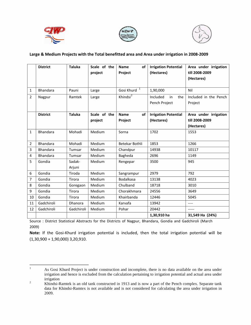
Large & Medium Projects with the Total benefitted area and Area under irrigation in 2008-2009
District Taluka Scale of the
project Name of Project
Irrigation Potential (Hectares)
Area under irrigation till 2008-2009 (Hectares)
1 Bhandara Pauni Large Gosi Khurd 1 1,90,000 Nil
2 Nagpur Ramtek Large Khindsi2 Included in the Pench Project
Included in the Pench Project
District Taluka Scale of the project
Name of Project
Irrigation Potential (Hectares)
Area under irrigation till 2008-2009 (Hectares)
1 Bhandara Mohadi
Medium Sorna 1702 1553
2 Bhandara Mohadi Medium Betekar Bothli 1853 1266
3 Bhandara Tumsar Medium Chandpur 14938 10117
4 Bhandara Tumsar Medium Bagheda 2696 1149
5 Gondia Sadak- Arjuni
Medium Rengepar 3500 945
6 Gondia Tiroda Medium Sangrampur 2979 792
7 Gondia Tirora Medium Bodalkasa 13138 4023
8 Gondia Goregaon Medium Chulband 18718 3010
9 Gondia Tirora Medium Chorakhmara 24556 3649
10 Gondia Tirora Medium Khairbanda 12446 5045
11 Gadchiroli Dhanora Medium Karvafa 13942 ----
12 Gadchiroli Gadchiroli Medium Pohar 20442 -----
1,30,910 ha 31,549 Ha (24%)
Source : District Statistical Abstracts for the Districts of Nagpur, Bhandara, Gondia and Gadchiroli (March 2009)
Note: If the Gosi-Khurd irrigation potential is included, then the total irrigation potential will be (1,30,900 + 1,90,000) 3,20,910.
1 As Gosi Khurd Project is under construction and incomplete, there is no data available on the area under
irrigation and hence is excluded from the calculation pertaining to irrigation potential and actual area under irrigation
2 Khindsi-Ramtek is an old tank constructed in 1913 and is now a part of the Pench complex. Separate tank data for Khindsi-Ramtex is not available and is not considered for calculating the area under irrigation in 2009.

Minor Irrigation Tanks in Project as of April 2009
Source: Government of Maharashtra, Water Resources Department, Nagpur Division Chief Engineer, Minor Irrigation Department, Regional Division: Pune (2008 Abstracts
Geographical Studies: Area and % of the districts within the Project Area
Sr.no District Area of the district within the project area (sq.kms)
% of the total project area
% of the area of district
1 Bhandara 3908.75 28.56 100
2 Gadchiroli 3443.17 25.16 23
3 Nagpur 2424.71 17.54 24
4 Gondia 2279.79 16.65 42
5 Chandrapur 1654.73 12.90 14
Total Area 13711.15 100 Source: Based on Survey of India Topographical sheets
District Maalguzari Taalav Total Minor Irrigation Structures
No. Irrigation Potential (hectares)
No. Irrigation Potential (hectares)
Bhandara 1434 14564 1770 33099
Gondia 219 5202 499 18755
Gadchiroli 381 4715 477 7330
Chandrapur 285 5177 393 11026
Nagpur 30 6150 156 5161
Total 2349 35808 3295 75371

Number of land holdings, area in hectares and Avg. size per holding in the Project area.
District Total No. of Land Holding
Area in Hectares Average size / holding (in ha)
Bhandara 1,89,913 2,04,845.6 1.08
Nagpur 39,927 85,044.51 2.13
Gadchiroli 50,333 83,552.78 1.66
Gondia 89,373 96,522.84 1.08
Chandrapur 33,985 71,708.35 2.11
Total for the Project area
4,03,531 5,41,674.08 (5416.74 sq.km)
1.34
Total project area : 13711.15 sq.km Proportion of cultivated area to total project area : 39.51%
Source: (Agriculture census 2001)
Population Studies: Population of Districts in Wainganga Basin (Maharashtra) and Project Area
Sr. No.
District Total Population of District 2001
Decadal Growth Rate (2001-2011)
Projected population 2011
Density (Persons/Sq.km)
project area (sq.km.)
Estimated Population in the project area in 2011
1. Bhandara 1136146 5.52 1198810 293 3908.75 11,45,264
2. Gondia 1200707 10.13 1322331 253 2279.79 5,76,787
3. Gadchiroli 970294 10.46 1071795 74 3443.17 2,54,795
4. Chandrapur 2071101 5.95 2194262 192 1654.73 3,17,706
5. Nagpur 4067637 14.39 4653171 470 2424.71 11,28,000
TOTAL 13711.15 34,22,552
Source: Census of India (1991-2001 and 2011)

Livelihood Studies: Distribution of Population in urban, rural, agriculture, fisheries and forestry categories in 2011 District Total Urban Rural Populati
on Dependent on agriculture
% of forest in the region
People Dependent on Forests for Livelihoods (includes shepherds)
Population dependent on riverine fisheries (estimation based on ground surveys)
Remaining population (in household industries, small traders, handicrafts, services, etc.)
Bhandara 1145264 211874 933390 376792 31.28% 174104
Nagpur 1128000 759144 368856 175967 23.97% 46235
Gadchiroli 254795 27773 227022 106554 78.61% 94700
Gondia 576787 85941 490846 188263 44.55% 134801
Chandrapur 317706 111515 206191 92928 35.52% 40231
Total 3422552 1196247 2226305 940504 490071 470604 325126
% to the total population
34.95% 65.05% 27.48% 14.32% 13.75% 9.50%
Avg Tribal Population in Project Area :18.37%
Estimated forest dependent population based on livelihood dependency : 28.07%
Tribal population in Maharashtra : 8%

Estimation of Water Demand: Gross Annual Water Demand from 2011 to 2031
Sr. No.
Water Use Annual Water Demand in cubic metres in 2011
Annual Water Demand in cubic meters by 2021
Annual Water Demand in cubic meters by 2031
1 Domestic Supply
186 million cubic meters 205 million cubic meters 225 million cubic meters
2 Agriculture 1105 million cubic meters
1300 million cubic meters
3250 million cubic meters.
3 Forest 96 million cubic meters 249 million cubic meters 249 million cubic meters
4 Fisheries ----- ------- -------
5 Industries 78 million cubic meters 209 million cubic meters 485 million cubic meters
Total Water Demand
1465 million cubic meters
1963 million cubic meters
4209 million cubic meters
Based on this information projects were identified and prioritized as given below,
Category Sub-category
Name of Project No. of projects Identified
A.
Water Resources Development
A. 1. Barrages on the mainstream 35
A.2 Barrages on the major tributaries 55
A.3 Renovation of existing Irrigation structures
A.3.1. Desiltation, repair and maintenance of Minor Tanks
7
A.3.2. Desiltation, repair and maintenance of Malguzari Tanks
7
A. 4. Alternatives for the Gosekhurd Dam Lift Irrigation Schemes
1
A. 5. Rehabilitation & Resettlement Schemes 1

A. 6.
Prevention of evaporation and other water losses
1
A. 6.
Groundwater Resource Development 1
A. 7. Watershed Development
A.7.1 Eco Development 8
A.7.2 Watershed Development and Catchment Area Treatment
10
B. Water Resources Management
B.1.
Development in Agriculture
B.1.1.
Gal-per Lands 7
B.1.1.b. Establishment of Water Users Associations 1
B. 1.2.
Development of Fisheries (Cold storages and piers)
3
B.2.
Water Supply and Sanitation schemes
B.2.1.
Water Supply and Sanitation to Urban areas 90
B.2.2
Water Supply and Sanitation to Rural Areas 300
B.3.
Flood Prevention and Mitigation 17
B.4.
Intra and Inter Basin transfer 0
C.
Water For Energy 315
D.
Water for Tourism
D.1.
Navigation upstream of Gosekhurd Dam 28
D.2.
Tourism Projects
E.
Research, Investigation and Data Collection Projects
9
Total projects identified 896
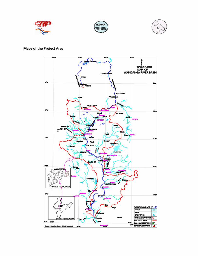
Maps of the Project Area

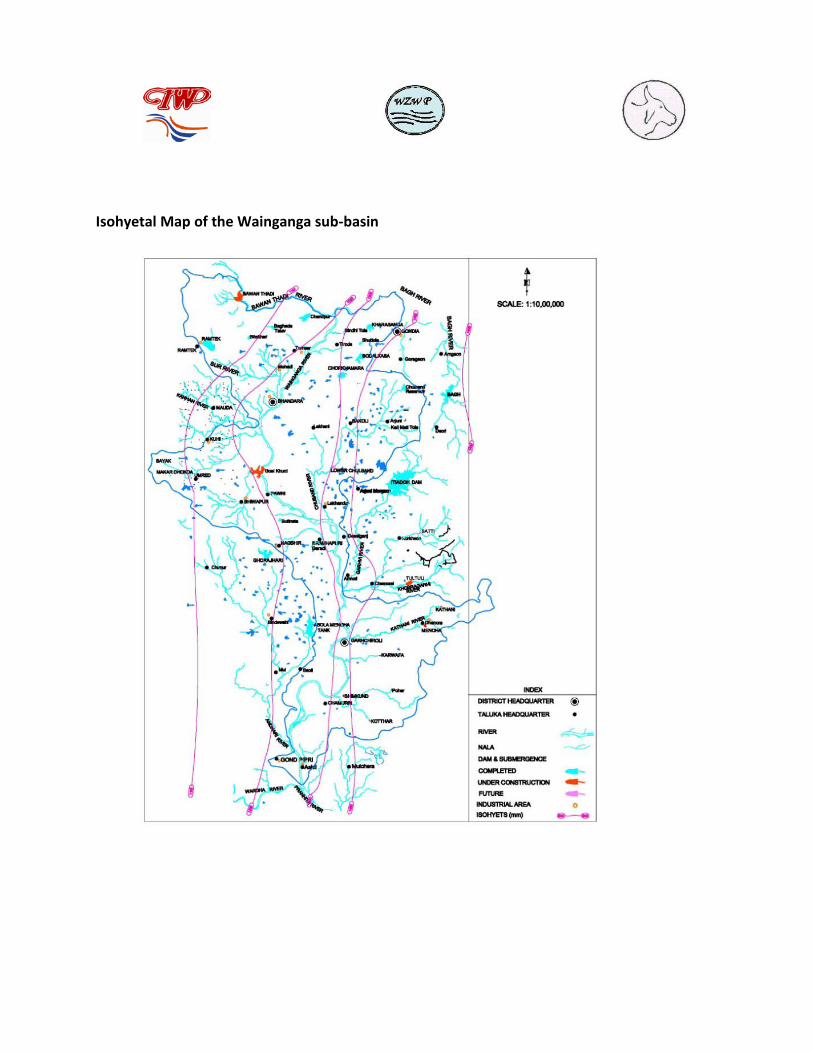
Isohyetal Map of the Wainganga sub-basin

LIST OF PARTICIPANTS AT VARIOUS MEETINGS The list provides details of participants of various meetings and consultations held during the year. Since people from various communities and smaller habitations were consulted during the year; the list is not exhaustive but only indicative and includes the names of key contact persons in various villages.
Sr.No. Name Organization (if any)
Contact Details
1. Mr. Manish Rajankar BNVSAM 9423118307
2. Mr. Ijamsai Katenge Amhi Amchya Arogyasathi, Gadchiroli
9422728937
3. Mr. Dileep Pandhere BNVSAM 9403906703
4. Mrs. Rekha Panke 07184-254328, Pauni, Bhandara
5. Mr. Keshav Gurnule Shrishti 9420144035
6. Mr. Manohar Bhrushundi 0712-2750511 Nagpur
7. Mr. Patiram Tumsare Fisheries Self Help Group Co-ordinator at Nawegaon Bandh (Jambhli Village)
Nawegaon Bandh, Gondia
8. Mr. Mahendra Raut Researcher, BNVSAM
9. Mr. Harishchandra Borkar Jhadiboli, Jhadipatti (Linguist and Researcher on Tribal Arts)
Rengepar, Bhandara
10. Dr. Manohar Naranje Archeologist Wardha
11. Mr.Pramod Kalbande Vidarbha Regional Editor, Sakal Daily
Hingna, Nagpur
12. Mr. Vilas Bhongade Gosekhurd Project Affected Peoples’ Committee
Nagpur
13. Mr. Gajanan Bagde Jhadiboli, Jhadipatti (Linguist and Researcher on Tribal Arts)
Arjuni Morgaon, Bhandara
14. Mr. Uttam Gharat Nawegaon Bandh, Gondia
15. Ms. Rashmi Mahajan Gomukh, Field Co-ordinator

16. Ms. Pushpalata Turkar Sewing Classes in Village for women
Biloria, Gondia
17. Mr. Uttam Nagpure Biloria, Gondia
18. Dr. Pradeep Rokade Sarpanch, Dhapewada Dhapewada, Bhandara
19. Mr. Shivlalji Parihar Farmer Kawlewada, Bhandara
20. Ms. Savitri Damhaye Sarpanch, Kawlewada Kawlewada, Bhandara
21. Ms. Tijyabai Barve Roha, Bhandara
22. Mr. Suresh Ishwarkar Fisherman Roha, Bhandara
23. Mr. Rajhans Bhute Fisherman Soundad, Bhandara
24. Mr. Tukaram Khangal Fisherman Mendha, Bhandara
25. Ms. Kashibai Patre Sarpanch, Shivni Gadchiroli Sarpanch, Shivni Gadchiroli
26. Dr. Aparna Margunwar Botanist, Shri Sai Baba Shaikshanik Vidyalaya, Armori, Gadchiroli
Armori, Gadchiroli
27. Mr. Margunwar Poet, and farmer Armori, Gadchiroli