Embed Size (px)
Citation preview

1
International Fund for Agricultural Development
Union of the Comoros
GEF MSP
Integrated Ecological Planning and Sustainable Land Management in Coastal Ecosystems in the Comoros
March 2008
MEDIUM-SIZED PROJECT PROPOSAL REQUEST FOR FUNDING UNDER THE GEF Trust Fund

2
List of Acronyms
AVD Village Development Associations CAADP Comprehensive Africa Agriculture Development Programme CNP National Steering Committee COSOP Country Strategy and Opportunities Paper CRCP Regional Committee for Programme Coordination DSCRP Growth and Poverty Reduction Strategy Document EOP End of Project ExA Executing Agency FA Focal Area FAO Food and Agricultural Organization GEF Global Environment Facility GOC Government of Comoros IA Implementing Agency IEM Integrated Ecosystem Management IFAD International Fund for Agricultural Development INRAPE National Institute of Research on Agriculture, Fisheries and Environment IO Intermediate Operators LD Land Degradation LOP Life of Project MDG Millennia Development Goals MPA Marine Protected Area MPE Ministry of Production and Environment MSP Medium Size Project NAPA National Action Programme for Adaptation NEPAD New Partnership for Africa’s Development NRM Natural Resources Management NSHDP National Sustainable Human Development Programme OIP Intermediate Principal Operators OPAS Offence for Social Action OS Specialized Organizations PA Protected Area PAE National Action Plan PCU Programme Coordination Unit PDL Local Development Plans PDV Village Development Plans PIF Project Identification Form PIR Project Implementation Report PNE National Environment Policy PTBA Annual Work Programme and Budget PTR Programme Terminal Report PY Project Year QPR Quarterly Programme Report RES Reward for Environmental Services SCRP Growth and Poverty Reduction Strategy SDI Intensive Development Sites SIDS Small Island Developing States SIP Strategic Investment Programme SLM Sustainable Land Management

3
SNB National Biodiversity Strategy SO Strategic Objectives SSA Sub-Saharan Africa TOR Terms of Reference UCP Programme Coordinating Unit UNCBD United Nations Convention on Biodiversity UNDP United Nations Development Programme UNCCD United Nations Convention to Combat Desertification UNFCCC United Nations Framework Convention on Climate Change URSE Regional Monitoring Units WB World Bank WWF World Wildlife Fund

4
PART I - PROJECT 1. PROJECT SUMMARY a) PROJECT RATIONALE, OBJECTIVES, OUTCOMES/OUTPUTS, AND ACTIVITIES. Located North of the Mozambican channel between Madagascar and the African contient the Comoros archipelago is comprised of four main islands Grande Comore, Anjouan, Moheli, and Mayotte (for purposes of the proposed project the latter island which is under French jurisdiction, will not be discussed further). The three islands, are characterized by high topographic relief and radial drainage associated with their volcanic origins. Recent population projections (2005) estimate a national population of approximately 800,000 occupying a total land area of 1,826 km2, equivalent to 438 persons per km2. The national economy is dominated by agriculture of which the major exports are vanilla, ylang-ylang, and cloves. Fisheries remains largely artensanal in nature. Sharing biogeographical affinities with Madagascar, the Comoros has a rich biodiversity that includes some 2,000 native plants of which an estimated 33 % are considered endemic. The tropical and sub-tropical moist broadleaf forests of the Comoros represents one of World Wildlife Fund's (WWF) 200 most significant global biomes. Simiarly, the country’s coastal ecosystems, due to their biological distinctiveness, have been identified by WWF as one of the world's 43 marine priority regions. Despite the global importance of the archipelago's biodiversity, the islands are charcterized by large areas of degraded forest habitat (at present there is only an estimated 30 % of the original forest area left). Coastal environments similarly appear to be increasingly at risk. Major threats to the environment include loss of forest cover due to coversion of land to agriculture and demand for fuelwood, non-sustainable fishing practices, coral and sand mining and overfishing in neashore waters. Major underlying casual factors driving these threats include a high degree of poverty, a high population growth rate, and population density. Exacerbating the aforementioned impacts on the country’s natural resources base are the insidious effects of climate change which over time are expected to have a negative impact on the country’s already vulnerable agriculture and natural resources. Specific threats that have been identified in the country’s first communication to the United Nations Framework Convention on Climate Change (UNFCCC) include: (i) reductions in agricultural and fishing production, (ii) increased saline intrusion in coastal aquifers, (iii) disappearance of reefs and beaches, and increase risk of malaria and other vector transmitted diseases. The Government of Comoros (GOC) recognizes the threats to the country's natural resource base and direct linakges to the demographic and socio-economic characteristics of the country. In response, it prepared an environmental action plan (1994), environmental legistation (1995), and has ratified all relevant international conventions including UNCBD (1994), UNFCCC (1994), and UNCCD (1998). Comoros also recently completed the National Action Programme of Adaptation (NAPA) in 2006. Moreover, in the country's recently approved national Growth and Poverty Reduction Strategy promoting a healthy environment in support of sustainable development was explicitly identified as one of 7 major development axes. Priority programmes identified under this axis, include natural resources conservation,

5
soil restauration and sustainable forestry management, and integrated management of the coastal zone. To address some of the aforementioned issues, underlying root causes and constraints, the International Fund for Agricultural Development (IFAD) has, together with GOC, prepared the National Sustainable Human Development Programme (NSHDP). The goal of the new Programme is to reduce poverty by promoting a better management of natural resources in order to raise agricultural production. Specific programme components are : (i) strengthening of the institutional framework, (ii) rehabilitation and sustainable management of the village terroirs, (iii) support for local initiaves derived from international remittances from the Comorians that live abroad, (iv) infrastructure, and (v) programme management. In the Comoros, environmental issues associated with land degradation and deforestation are highly inter-connected in the steep-to, rapidly draining topography characteristic of the archipelago. Loss of forest cover, coupled with intense rainfall and steep topgography have a direct and immediate impact not only in the area of deforestation but also contributes to offsite impacts in the country's coastal and near-shore marine environments. Building on several of the aforementioned activities supported under NSHDP, the IFAD Programme provides a unique opportunity for GEF to address many of the Comoros' environmental issues through adopting and integrated ecosystem management approach (IEM); such an approach that would achieve multiple global benefits in the case of the Comoros and other “high” island ecosystems. The proposed “Integrated Ecological Planning and Sustainable Land Management in Coastal Ecosystems in the Comoros” Medium Size Project (MSP) will be a “blended” project, fully integrated into the IFAD supported NSHDP. The project goal is to address non-sustainable land use practices and concurrent loss of biodiversity through the development and adoption of an ecosystem based approach in Comoros' rural land use planning and development activities. Project objectives are to support community-led, ecological planning and the subsequent identification and implementation of field and related enabling activities designed to address priority natural resource use conflicts affecting ecosytem “health” and the provision of environmental “goods and services” contributing to losses in economic productivity and human well-being. Global environmental objectives are: (i) to reduce and possibly reverse current trends in land degradation through supporting sustainable land management (SLM) policies and practices that generate global environmental benefits; and (ii) the conservation and sustainable use of biodiversity and the maintenance of the ecosystem goods and services that biodiversity provides to society. The MSP has four project components: (i) Environmental Policy and Planning, (ii) IEM Plan Implementation and Protected Areas, (iii) Increased Institutional Capacity, Environmental Education and Public Awareness, and (iv) Project Management, M&E, and Information Dissemination. The Environmental Policy and Planning component has two sub-components. The main objective (output) of the Environmental Policy sub-component is to create an enabling environment to support the development and adoption of an ecosystem based approach in spatial planning processes in Comoros' rural landscapes. This will be addressed primarily through providing support for public fora to facilitate dialogue with senior policy makers, travel for policy makers to visit field sites where IEM Plans have been prepared and are under implementation, and a series of policy studies (e.g. environmental "goods and services," and financial sustainability of protected area systems).

6
The objective of the component’s Environmental Planning sub-component is to develop community-led ecosystem management plans for specific coastal ecosystems. One IEM plan will be developed for up to 6 sites (2 per island). These sites, which to varying degrees overlap with areas supported under the IFAD Programme, are: (i) Sima-Bimbini and Nyumakele (Anjouan); (ii) Itsamia-Lac Dziani Boundouni-Hamavouna and Djando (Mohéli); and (iii) Forét du Kartala - Tsinimouapanga-Kourani - Nioumamilima - Kourani - Tsinimouachongo - Kanzilé and Forét La Grille - Mbeni - Dimadjou - Batou (Grande Comore). Activities in support of plan development will include: (i) sensitization and training of the local communities, and building consensus on (ii) the existing significance of the ecosystem (including provision of environmental "goods and services"); (iii) the status of the present and projected future “rehabilitated” ecosystem (to include mapping), and (iv) priority interventions leading to a “restored” ecosystem. Key outputs will include: (i) guidelines to be used as reference to identify and design GEF-supported activities, (ii) a baseline map (the existing situation), and (iii) a draft IEM plan (an agreed on plan which represents what the communities feel is a rehabilitated “healthy” ecosystem supported by priority investments). The main outcome of the Environmental Policy and Planning component is to facilitate the establishment of improved policy and planning frameworks to support SLM through an IEM approach designed to restore/protect biodiversity in production landscapes. Most of the MSP resources will be used to support specific priority interventions in the previously identified ecosystems under the IEM Plan Implementation and Protected Areas component. As noted above, site specific priorities will be identified through a community led process facilitated by the ecosystem management plan developed under sub-component 1.2. Where more than one village community shares an ecosystem (e.g. a watershed), the project would facilitate collaborative efforts to develop a coherent approach to address system-wide issues of common concern. Examples of possible component investments that could complement IFAD investments during the implementation of the IEM plan include: (i) reforestation activities with indigenous species; (ii) mangrove restoration and management; (iii) strategies in support of the sustainable harvesting of emergent reefs; (iv) development of small-scale alternative livelihoods designed to reduce pressure on the pilot site’s natural resource base (e.g., non-forest products, medicinal herbs); (v) pilot eco-marketing/green (bio) labeling activities; (vi) pilot activities in support of ecologically sustainable ylang-ylang production; (vii) community based efforts to address solid waste disposal; and (viii) applied ecological studies. An existing (or proposed) protected area (PA) is located in proximity to four of the six IFAD Programme sites. These are: (i) Bimbini (Anjouan); (ii) Lac Dziani (Mohéli); and (iii) Forét du Kartala and Forét La Grille (Grande Comore). It is expected that specific interventions designed to strengthen existing or support the creation of new PAs will occur through the plan preparation process described under sub-component 1.2. Likely interventions supported during plan implementation will include: (i) activities to facilitate the declaration of new PAs, (ii) the preparation of (or updating of existing) management plans, (iii) boundary demarcation, (iv) promotion of co-management approaches with direct participation my local communities. Where investments in infrastructure and equipment are both appropriate and thought to be financially sustainable (determined through the management plan process), these will also be supported.

7
The main outcomes of the component are: (i) a proven approach that fully integrates ecosystem principles into a diverse range of production landscapes; and (ii) increased sustainability of Comoros’ national protected area system through the strengthening of existing protected areas and/or reducing pressure on candidate sites currently being considered for future designated protective area status. The Institutional Capacity and Environmental Education and Public Awareness component has two sub-components. The main objective of the capacity building sub-component is to increase capacity among project stakeholders at the level of the village “lead” and environmental associations (Ulanga), local (mayor’s office), regional (island) and national government and NGOs to support the development and inclusion of environmental planning and management principles in rural-based economic development. Under this sub-component, the project would finance the following: technical assistance, the development of one or more training modules, equipment and materials, workshops, short-courses, and cross-site field-visits. The expected outcomes of this sub-component are: (i) increased awareness among institutions and individuals responsible for rural-based economic development planning of ecosystem processes and functions and how the latter are affected by human interventions; (ii) empowerment of local communities and increased effectiveness in participation in local management decisions affecting their natural resources and environment; and (iii) improved capacity to work across disciplinary lines among NGO and public officers responsible for rural development planning and implementation. The objective of the public awareness sub-component is to increase awareness among local communities, decision makers and the public at large of the options that exist to achieve an improved environment and the benefits that would accrue from life quality and associated livelihoods. Under this sub-component, the Project could support the design and implementation of public awareness strategies and curricula development for village schools. The expected outcomes of this sub-component include increased acceptance of more environmentally-sustainable practices in the rural space and greater public awareness of the ecological, economic and social significance of the Comoros islands’ environment. Under the MSP’s Project Management, M&E, and Information Dissemination component, as part of a “blended” operation, the management sub-component will be integrated into the overall Programme’s management structure (see Section on Implementation Arrangements below). The main outcomes would be a project implemented in a timely and efficient manner. Under the MSP’s monitoring and evaluation sub-component, indicators developed during project preparation would be integrated into the programme’s M&E system. Specific outputs are: (i) an M&E plan consistent with IFAD and GEF requirements, and (ii) timely M&E reports conforming to GEF and IFAD requirements. The Project’s information dissemination sub-component will support the dissemination of project results aimed at sharing “lessons learned” with project beneficiaries and with other individuals and institutions involved with the development and application of an IEM approach to address land degradation issues in Small Island Developing States (SIDS). This would be done through providing support for conferences, publications and a homepage. The main expected outcomes are: (i) increased public support for the development and adoption of

8
IEM approaches in the planning and management of rural space in SIDS; and (ii) adoption of relevant experiences from this project by SIDS in the region and beyond. It is proposed that the MSP would be implemented over a 4 year period (rather than the more typical three years). This is felt justified due to the weak institutional structure and low absorbative capacity of local communities (see Section 1b below). The US$ 1 million grant would be matched by US$ 1,872,000 million in co-financing as required by GEF. At present, it is felt that selected activities supported under the IFAD Programme could be used to meet this requirement divided among the loan, government, beneficiary and Disapora counterpart contributions.. b) KEY INDICATORS, ASSUMPTIONS, AND RISKS Key indicators will be: The establishment of policy, regulatory and planning “frameworks” that support an ecosystem based approach; one that adopts and promotes sustainable land management (SLM) and biodiversity conservation principles and objectives. Quantifiable results supporting this indicator include: the passage of relevant legislation, policy statements, development of enabling strategies and/or action plans, and official inter-village agreements to work collaboratively on environmental issues of common interest. Results would be relevant and measured at the national, sub-national (i.e., island), or village levels. An increase in the adoption by communities of an ecological based approaches in rural land use planning and subsequent implementation. This indicator is directly associated with the project success, dissemination of information describing the project approach and results, and the establishment of an enabling environment to facilitate future adoption by interested communities. Evidence of some environmental “goods and services” and underlying processes being restored in rural landscapes. This is a difficult indicator to quantify during the Life of Project (LOP) in light of the complexity of ecological processes and dependence on independent variables (e.g., amount and periodicity of rainfall) and the substantial time required to establish trends to “average out” short term variation. In response, simple, appropriate surrogate indicators will be identified and incorporated into the integrated M&E Plan. These might be presence of key bioindicators (e.g., contaminant intolerant aquatic animal and vegetative species) and establishment and areal extent of restored habitat. An ecological baseline will be established to support future, long-term M&E activities. Loss of biodiversity is reversed or at least slowed. Selected indicator species currently classified as endangered or at risk will be monitored using techniques appropriate to enable village associations to implement the programme.
Key assumptions will be: The NSHDP and MSP can be successfully blended. This is a critical assumption as most benefits from Project are due to the number of close linkages between the two initiatives.

9
Policy makers are interested in considering new approaches. A second key assumption to establishing an enabling environment needed to sustain and replicate the proposed approach supported under the MSP is that policy makers are interested in participating in public fora, cross-site visits, and considering (and hopefully) implementing relevant policy options supporting an ecosystem-based approach in rural planning frameworks. Village associations will work collaboratively. To effectively address environmental issues of common interest to multiple villages sharing a bounded ecosystem will require village associations to work closely together. Counterpart financing. Government and participating village provide the agreed on counterpart (in-kind) financing. Key risks will be: Institutional capacity. The greatest risk is the weak institutional environment that characterizes much of the country’s institutions at both the national and sub-national levels. This would likely affect the efficacy of project implementation, etc. The proposed MSP would address this through: (i) providing signfiicant support through capacity building to both public institutions and NGOs, (ii) working through intermediary service providers and (iii) channeling most of the resources through community-led actvities. Land tenure. A second potential risk is associated with the degree of uncertainty surrounding existing land tenure which might pose a constraint in the development and implementation of IEM plans. The situation is exacerbated by the highly complex social structure characteristic of Comoros. There appear to be a number of barriers that constrain communities from working together through a collaborative approach to address issues of common concern. Appropriate institutional means will have to be identified and supported to gain the confidence and trust of communities. Co-management. Specfically with respect to support to protected areas, a past evaluation of the GEF-supported Moheli Marine Park indicated that notwithstanding a number of positive achievements associated with the application of co-management principles it was not a universal pancea. Major constraints that affected the achievement of overall project obectives were lack of government enforcement and the nature and severity of root causes underlying the threats to the PA including overpopulation and poverty. These risks are likely to be relevant to activities designed to support PAs under the MSP. Proposed migitation measures include: (i) supporting alternative income-generating activities, (ii) use of ecoguards and training of local community representatived in PA monitoring and patrolling, and (iii) community-empowerment through co-management approaches. External risks. Finally, risks beyond the control of the project but that nevertheless could affect project outcomes include political instability, climatic variability and natural hazards. 2. COUNTRY OWNERSHIP
a) COUNTRY ELIGIBILITY
The Government of Comoros (GOC) has ratified all relevant international conventions including UNCBD (1994), UNFCCC (1994), and UNCCD (1998).
10
b) COUNTRY DRIVENNESS
The GOC recognizes the threats to the country's natural resource base and direct linkages to the demographic and socio-economic characteristics of the Comoros. In addition to signing the aforementioned conventions, Government prepared an environmental action plan and enabling legislation in 1994 and 1995, respectively Comoros also recently completed its National Action Programme of Adaptation (NAPA) in 2006. Moreover, in the country's recently approved national Growth and Poverty Reduction Strategy, promoting a healthy environment in support of sustainable development was explicitly identified as one of 7 major development axes. Priority programmes identified under the environment axis, include: natural resources conservation, soil restoration and sustainable forestry management, and integrated management of the coastal zone. The Comoros has also made signficant progress at the site level. The Moheli marine protected area (MPA) has broken new ground in developing and testing co-management principles in the archipelago. Past evaluations have documented the considerable success achieved in empowering local communites to participate in NRM decision-making, increasing local involvement in conservation, and in the use of traditional knowledge in the absence of scientific information. There also seems to have been some success in working with the local private sector (coastal tourist hotels) in efforts to protect adjacent sites of particular interest to their clientel. More recently, a new approach to address multiple village issues has been attempted in promoting the development of inter-village committees associated with the on-going process to create the Coelacanth national park. A key factor in this approach is the role of the Ulanga (nature) Associations, community based environmental associations that exist in almost all Comorian villages. These achievements can be used as a basis to build and expand on in addressing the county's environmental situation Another local innovation that attempts to address many of the aforementioned land degradation issues and underlying causal factors at the site level originated in the 1970s in response to the growing pressure on the land. Termed d'embocagement, this technological approach represents an intensified agro-sylvo-pastoral integrated farming system consisting of the combined use of wind breaks, confined grazing of livestock, increased use of organic fertilizer, and other site-specific related interventions. As an approach it is considered to be highly successful where it has been adopted in the Comoros and been supported by a number of development agencies. It is clear that while the Comoros faces significant environmental problems and constraints impeding the development of effective remedies that address said problems, there also exists a significant basis to build on to assist the country in the task a head. Where efforts directed at addressing environmental issues have proven successful in the past, these have been taken into account in the proposed MSP. 3. PROGRAM AND POLICY CONFORMITY
c) PROGRAM DESIGNATION AND CONFORMITY
The proposed project fits fully with the GEF-4 Strategy for the Land Degradation Focal Area (FA). First, it will support a landscape approach that fully integrates ecosystem principles as supported by the UNCBD. More specifically, it is fully compatible with the LD FA Objective
11
through promoting the development and implementation of Sustainable Land Management (SLM) policies and practices that generate both global environmental benefits and support local and national development. Of particular note is the MSP’s utilization of cross-cutting opportunities for achieving impacts with an integrated ecosystem and landscape perspective. Key FA principles which will be adopted in project design include: (i) strengthening the enabling environment, (ii) supporting institutional capacity development and (iii) promoting an integrated and program framework-based approach at the landscape level. Particularly relevant principles identified under GEF-4 include: (i) placing emphasis on the management of the interface between different land use systems, (ii) allocating resources in a balanced and sensitive manner (within country) to areas affected by LD. Strategic Objective 1 (SO # 1), (….creation of an enabling environment that will place SLM in the mainstream of development policy and planning….) will be supported through the activities supported under the Project’s Environmental Policy sub-component. The GEF LD FA SO #2 (…..generate mutual benefits for the global environment and local livelihoods through the upscaling of SLM investements…) will be fully supported by activities supported under the Project’s Environmental Planning, Plan Implementation, and Instiutional Capacity sub-components. Finally, one key issue which will be addressed responds to relevant results from recent STAP assisted studies on land degradation; namely a need for an increased contribution in GEF's LD portofolio on sustainable forest management with a focus on tropical ecosystems and the issue of deforestation and forest degradation. In addition to the aforementioned OPs, the proposed project will be supportive of the objectives stated under OP # 2 and #3 (coastal, marine and freshwater and forest ecosystems, respectively) of GEF's Biodiversity FA through providing support for the rehabilitation of existing and creation of new protected areas designated to conserve ecosystems of significant importance. Under this FA, the project targets indirectly the strategic objective (SO # 1) in catalyzing the sustainablity of PA systems through building on earlier efforts including supporting the needed institutional capacity as well as creation and diversification of the existing system. The project is mainly targetting SO #2, mainstreaming biodiversity in production land/seascapes and sectors designed will be relevant as IEM principles will be mainsteamed into IFAD's development assistance lending program in Comoros. Finally, the proposed Project would be compatible with well recognized principles in support of integrated ecosystem management (IEM) as it will promote cross-sectoral approaches to address ecological issues beyond a single habitat type. In this way, it will contribute to creating an enabling environment to support future “mainstreaming” of IEM principles in LD management systems through institutional strengthening and investments. The MSP's overall objectives and approach are fully in line with GEF's Strategic Investment Programme for Sustainable Land Management in Sub-saharan Africa (SIP). Specifically, the Project directly supports SIP’s long-term goal (….improved natural resources-based livelihoods by preventing and reversing land degradation…) and global environmental objective (…to prevent and reduce the impact of land degradation on ecosystem services in country-defined priority SSA ecosystems….). It will furthermore support 3 of SIP’s 4 main operational clusters. These are: (i) supporting on-the-ground activities for scaling up SLM (# 1); (ii) creating a conducive enabling environment for SLM (# 2); and (iii) developing effective SLM knowledge management, M&E, and information dissemination systems (#4). With respect to the latter, the Comoros provides an excellent opportunity to generate on-the-ground learning experiences suitable for application to other small island developing states

12
(SIDS) in both the region and beyond. Finally, the MSP directly supports SIP’s Targeted Investments’ modality which is designed to assist a country to pursue a progressively more programmatic approach to SLM over time; in this case starting with specific geographic, sectoral, and thematic entry points. Finally, the MSP M&E data collection and provision activities will be harmonized with the SIP’s Program M&E Desk once the latter becomes established and M&E procedures are developed and put into practice. The MSP has been included in the SIP’s 2007-2010 portfolio of operations. (see Annex D of GEF Project Executive Summary ). Finally, the Project is relevant to NEPAD’s Comprehensive Africa Agriculture Development Programme (CAADP) Pillar 1 (land and water management) particularly through its promotion of integrated ecosystem approach to coastal management.
d) PROJECT DESIGN (INCLUDING LOGFRAME AND INCREMENTAL REASONING)
The project goal of the proposed “Integrated Ecological Planning and Management in Coastal Ecosystems” Medium Size Project (MSP) will address non-sustainable land use practices and concurrent loss of biodiversity through the development and adoption of an ecosystem based approach in Comoros' rural land use policy, planning and development activities. Project objectives are to support community-led, ecological planning and the subsequent identification and implementation of field and related enabling activities designed to address priority natural resource use conflicts affecting ecosystem “health” and the provision of environmental “goods and services” contributing to losses in economic productivity and human well-being. Global environmental objectives are: (i) to reduce and possibly reverse current trends in land degradation through supporting sustainable land management (SLM) policies and practices that generate global environmental benefits; and (ii) the conservation and sustainable use of biodiversity and the maintenance of the ecosystem goods and services that biodiversity provides to society. The proposed MSP has four project components: (i) Environmental Policy and Planning; (ii) IEM Plan Implementation; (iii) Increased Institutional Capacity, Environmental Education and Public Awareness; and (iv) Project Management, M&E and Information Dissemination. The Environmental Policy and Planning component has two sub-components. These are respectively, the Environmental Policy and Planning sub-components. The main objective (output) of the environmental policy sub-component is to create an enabling environment to support the development and adoption of an ecosystem based approach including the “mainstreaming” of sustainable land management (SLM) and environmental principles generally and the conservation of biodiversity specifically in policy formulation and spatial planning processes affecting Comoros' rural landscapes. This will be achieved primarily through providing support for: (i) public fora to facilitate dialogue with senior policy makers, (ii) travel for policy makers to visit field sites where IEM Plans have been prepared and are under implementation, and (iii) a series of policy studies (e.g., environmental "goods and services," and financial sustainability of protected area systems) among others to support more informed policy formulation. Specifically, senior policy makers in the national and regional (insular) development, economy & finance, and production, fishing and agriculture ministries would be targeted and invited to participate in a series of public fora to include representatives from the private

13
sector, environmental NGOs, civil society. The objective of these fora would be to observe, discuss and evaluate the results, experience, and “lessons-learned” to date derived from project supported activities and assess their relevance to public policy formulation with respect to principles in IEM, SLM and conservation of biodiversity and their significance to rural development. A total of 9 public fora beginning in project year (PY) 2 (2009) are proposed. Similarly, a series of inter-island site visits will be supported to facilitate the comparative evaluation of project activities in differing land/seascapes. A total of 18 cross-site visits are included (each visit consists of 1 person visiting all project sites on the three islands over a 6 day period). Finally, a series of studies would be supported under this sub-component to address critical data gaps that serve as constraints to achieving improved policy formulation in the environmental and natural resources sectors. A total of 5 studies have been projected over the life of the project (LOP). The first study which would be initiated a priori to the others would support an analysis and subsequent development of participatory communications strategy to facilitate increased communications between local communities and decision makers. In addition, two other studies have been identified as priorities. These are: (i) assessing and quantifying in monetary terms the environmental “goods and services” provided in the project supported “ecosystems” (including “income” foregone attributable to existing environmental status of the sites) and investigating how best to implement a “Reward for Environmental Services (RES)” scheme (or similar such approaches) that provide incentives to local communities to adopt ecologically suitable land use practices; and (ii) examining relevant alternatives that may be applicable to Comoro’s nascent protected area system to generate revenues to at least partially offset administrative and management costs. Both studies have been identified as actions under the SCRP.1 The remaining studies will be determined following consultations with the communities in PY 1. These could include: (i) the relationship between land tenure and sustainable land use practices, (ii) development of environmental “health” indicators appropriate for monitoring and (iii) the role and significance of intensive production models (e.g., embocagement) in restoring ecosystem processes and functions. The objective of the component’s environmental planning sub-component is to develop community-led ecosystem management plans for specific coastal ecosystems. The objective of these community – led plans and the underlying processes leading to their development would be to: (i) spatially delimit inter-village areas shared between two or more villages that for project purposes would serve as an ecosystem (they can be defined by physical, political, and/or legal boundaries or a combination there-of); (ii) identify and agree on the major environmental issues and underlying causal factors and constraints that need to be addressed for their resolution; and (iii) agree on a prioritized series of actions needed to resolve these issues and contributing to the eventual restoration of the ecosystem. Specifically, activities in support of plan development would include: (i) sensitization and training of the local communities; (ii) facilitating reaching consensus on the existing
1 See relaunching the private sector in critical economic sectors (Axe # 2): Tourism Sector and promoting a healthy environment and guarantee the sustainability of development (Axe # 6).

14
significance of the ecosystem (including provision of environmental "goods and services"); (iii) determining the status of the present and projected future “rehabilitated” ecosystem (to include participatory mapping of the agreed on ecosystem); and (iv) identifying priority interventions leading to a “restored” ecosystem. This process would be integrated into and build on the complementary IFAD supported activities working through Village Development Associations (AVD) including preparation and awareness raising, training and reinforcement in the capacities of the associations and the development of terroir management plans (see Attachment 1 of Appendix 3 for more detail). One IEM plan will be developed per site to include up to 6 sites (2 per island). These sites, which to varying degrees would overlap with areas supported under the IFAD Programme, are: (i) Sima-Bimbini and Nyumakele (Anjouan); (ii) Itsamia-Lac Dziani-Boundouni-Hamavouna and Djando (Mohéli); and (iii) Hamaharnet and Mbadjini (Grande Comore). Three of the aforementioned six sites would be associated with an existing or proposed future protected area (see below). Key outputs would include: (i) guidelines to be used as reference to identify, prepare, and implement GEF-supported investment sub-projects (an illustrative draft of possible guidelines has been included in Attachment 1 of Appendix); (ii) baseline studies to include a baseline map (the existing situation); and (iii) a draft IEM plan (an agreed on plan which represents what the communities feel is a rehabilitated “healthy” ecosystem supported by priority investments). The main outcome of the environmental policy and planning component is to facilitate the establishment of improved policy and planning frameworks to support SLM through an IEM approach designed to restore/protect biodiversity in production landscapes. The component’s objectives, outputs and outcomes support several of Comoros’ existing policy objectives and proposed actions. The Government of Comoros (GOC) has identified the integration of environmental principles in the country’s development planning process and sector development plans as a high priority. Under Millennia Development Goal (MDG) Objective # 7 (to ensure a sustainable environment) a priority action for the Comoros is to integrate the principles of sustainable development in the nation’s policies. Similarly, a key area and supporting action identified under the National Environment Policy (PNE) and National Action Plan (PAE) respectively are promoting the integration of environmental aspects into national agricultural policy. The importance of this priority is underscored further in the country’s National Biodiversity Strategy (SNB) which identified the following key actions: (i) the revision of the existing policies in the domain of agriculture, forestry, tourism and urbanization; (ii) examining how to mainstream biodiversity into said policies; and (iii) mainstreaming biodiversity into other sector policies for water, energy, and fisheries as key actions. Under the IEM plan implementation component resources will be used to support specific priority interventions leading to the eventual restoration of processes and functions in ecosystems previously identified, delimited, and agreed to under the Project’s environmental planning sub-component. As noted above, site specific priorities will be identified through a community led process leading to the preparation of an ecosystem management plan developed under sub-component 1.2. Where more than one village community shares an

15
ecosystem (e.g., a watershed), the project would facilitate collaborative efforts between villages to develop a coherent approach to address system-wide issues of common concern. Examples of possible component investments that could complement IFAD investments during the implementation of the IEM plan include: (i) reforestation activities with indigenous species; (ii) mangrove restoration and management; (iii) strategies in support of the sustainable harvesting of emergent reefs; (iv) development of small-scale alternative livelihoods designed to reduce pressure on the pilot site’s natural resource base (e.g., non-forest products, medicinal herbs); (v) pilot eco-marketing/green (bio) labeling activities; (vi) pilot activities in support of ecologically sustainable ylang-ylang production; (vii) community based efforts to address solid waste disposal; and (viii) applied ecological studies. Specific investments will be determined through the community consultation and formulation process described above. However, investment profiles have been prepared to illustrate in more detail the nature of activities supported under this component (see Attachment 2 in Appendix 5). As noted above, three of the six sites would be associated with existing or proposed future protected areas. These are: (i) Forêt La Grille (Grande Comoros), (ii) Lac Dziani Boundouni (Mohéli), and (iii) Bimbini – Ile de la Selle Zone (Anjouan). Criteria used to select these sites included: (i) degree to which they overlapped with the IFAD project sites, (ii) their importance in contributing to the conserving and protection of biodiversity, (iii) degree of threat and the potential for the blended project to support activities that contribute to a reduction of pressure on natural resources in and around the PA, and (iv) the absence of likely alternative donor assistance to support the proposed site. See Attachment 3a - 3c in Appendix 5 for more detail on these sites. In addition to activities designed to address threats to the integrity of the protected areas through supporting economic activities in surrounding villages, there would be additional activities designed to strengthen the existing or support the creation of new PAs. Likely interventions include: (i) support to facilitate the legal declaration of new PAs, (ii) the preparation of (or updating of existing) management plans, (iii) boundary demarcation, and (iv) promotion of co-management approaches with direct participation by local communities. Where investments in infrastructure and equipment are thought to be financially sustainable (determined through the management plan process), these will also be supported (infrastructure would be small-scale in nature and likely limited to trails, interpretative signs, small, visitor centers (kiosk-like), and/or boundary demarcation. In at least two IFAD sites, Mbadjini (Grande Comore) and Boundouni-Hamavouna (Mohéli) there is likely to be forthcoming donor support for existing/proposed protected areas that are in proximity to project sites. These are Forét du Kartala (World Bank) and the Mohéli Marine Park (Indian Ocean Commission). If confirmed, the IFAD PCU will work closely with their respective counterparts to ensure that the respective IFAD project supported activities are complementary and increase chances of achieving a “win-win” situation where both biodiversity conservation and reduction of rural poverty can be mutually achieved. The main outcomes of the component are: (i) a proven approach that fully integrates ecosystem principles into a diverse range of production landscapes; and (ii) increased sustainability of Comoros’ national protected area system through the strengthening of existing protected areas and/or reducing pressure on candidate sites currently being considered for future designated protective area status.

16
These outcomes directly support key actions called for under the SCRP for the Period 2006 – 2009. Specifically Programme 2.6.2.2 and 2.6.5.5 of Axis #6 (to promote a healthy environment and guarantee the sustainability of development). Under the former programme priority actions include: (i) to put in place a network of terrestrial and marine protected areas representative of the natural patrimony of the Comoros; (ii) provide support for the adoption of co-management approaches involving local communities; and (iii) delimit specific sites followed by the implementation of co-management plans at 5 sites. Moreover, additional actions identified under the same programme would promote the development of economic activities compatible with the objectives of conservation of protected areas. Other relevant policy actions identified to support the aforementioned programme include: (i) assessments to evaluate the potential for alternative economic activities for surrounding communities, (ii) reinforcement of the capacity of individuals and/or groups to manage economic activities that support principles of the sustainable management of natural resources and (iii) putting in place sustainable financing. Under the latter programme (Programme 2.6.5.5), key actions include: the maintenance of soil fertility, restoration of degraded soils and sustainable management of forest resources with the following objectives: (i) sustainable management of forest resources, (ii) support for activities that lead to the protection and management of vulnerable sites and support the following actions - identification of vulnerable sites to agricultural expansion, develop a regimen to protect sites and support activities on management and protection of vulnerable sites. The Institutional Capacity and Environmental Education, and Public Awareness component has two sub-components. These are the Institutional Capacity and Environmental Education, and Public Awareness sub-components. The main objective of the capacity building sub-component is to increase capacity among project stakeholders at the level of the village “lead” and environmental associations (Ulanga), local (mayor’s office), regional (island) and national government and NGOs to support the development and inclusion of environmental planning and management principles in rural-based economic development. Under this sub-component, the project would finance the following: technical assistance, the development of one or more training modules, equipment and materials, workshops, short-courses, and cross-site field-visits. Specifically, training modules and supporting materials would be developed and equipment purchased to support short courses designed to address specific environmental issues faced by the participating villages within the context of the broader ecosystem. Illustrative examples of thematic modules include: (i) the consequences of unplanned solid waste disposal, (ii) unsustainable land use practices and its affects on erosion and down-stream impacts, and (iii) destructive fishing practices including gleaning of emergent reefs. The identification of the modules will be finalized following consultations with the communities. Unlike the training modules which will target villagers, support for workshops and short-courses under this sub-component would target professionals and technicians in the relevant main-line agencies and focus on demonstrating the benefits of integration of SLM and biodiversity conservation principles into rural development through an IEM approach. Cross-site visits would focus primarily on targeting non-participating communities to expose interested leaders and producers of the benefits of adopting an IEM approach in pilot sites.

17
The expected outcomes of this sub-component are: (i) increased awareness among institutions and individuals responsible for rural-based economic development planning of ecosystem processes and functions and how the latter are affected by human interventions; (ii) empowerment of local communities and increased effectiveness in participation in local management decisions affecting their natural resources and environment; and (iii) improved capacity to work across disciplinary lines among NGO and public officers responsible for rural development planning and implementation. This directly supports the 4th axis of the SCRP, (to promote the education and professional formation and thus the general improvement of human capital) as well as - reinforce capacity of individual and groups to manage economic activities in support of sustainable management, a priority action identified under SCRP 2006-2009 Action Plan (Programme 2.6.2.2: Conservation of natural resources and development of activities based on the richness of the flora and fauna of Comoros). The objective of the public awareness sub-component is to increase awareness among local communities, decision makers and the public at large of the options that exist to achieve an improved environment and the benefits that would accrue from life quality and associated livelihoods. Under this sub-component, the Project could support the design and implementation of public awareness strategies and curricula development for village schools. Specifically, under this sub-component the MSP would support the design of island-wide campaigns to increase public awareness of the significance of the Comoros environment, highlighting its role in supporting rural livelihoods, the existing status, and current threats. Each campaign would be guided by the development a priori of a public awareness strategy that would be prepared with the assistance of technical consultants. In the preparation of these island-specific strategies, the consultants would assess what are the most cost-efficient means to increase public awareness stratified by target group (e.g., radio, newspapers and other print media, television spots, the use of “jingles” etc.). Campaigns would be supported annually throughout the LOP. Under this sub-component, primary and secondary school curricula would be developed and integrated into schools from the project area that will be selected on the basis of their expressed interest in participating in this activity. A core curriculum would be developed and supported with complementary materials that focus on specific ecological themes relevant to both the immediate area and the Comoros generally. If deemed successful, it is expected that these would be eventually ‘mainstreamed” into the national educational curricula. The expected outcomes of this sub-component include increased acceptance of more environmentally-sustainable practices in the rural space and greater public awareness of the ecological, economic and social significance of the Comoros islands’ environment. This supports another SCRP priority action included under Programme 2.6.2.2, the sensitization of the local population of the importance and respect for the [the environment generally] and deposit of wastes specifically. Under the Project Management, M&E, and Information Dissemination Component there are three sub-components. These are the Project Management, M&E and Information Dissemination.

18
As part of a “blended” operation, the management sub-component would be integrated into the overall Programme’s management structure (see below). The main outcomes would be a project implemented in a timely and efficient manner. Under the MSP’s monitoring and evaluation sub-component, indicators developed during project preparation would be integrated into the programme’s M&E system. Specific outputs are: (i) an M&E plan consistent with IFAD and GEF requirements, and (ii) timely M&E reports conforming to GEF and IFAD requirements. For more detail on the MSP’s M&E plan see Appendix 6. The Project’s information dissemination sub-component will support the dissemination of project results aimed at sharing “lessons learned” with project beneficiaries and with other individuals and institutions involved with the development and application of an IEM approach to address land degradation and biodiversity conservation issues in Small Island Developing States (SIDS). This would be done through providing support for conferences, publications and a homepage. The main expected outcomes are: (i) increased public support for the development and adoption of IEM approaches in the planning and management of rural space in SIDS; and (ii) adoption of relevant experiences from this project by SIDS in the region and beyond. The proposed MSP will be a “blended” project, fully integrated into the IFAD supported NSHDP. It is proposed that the MSP would be implemented over a 4 year period (rather than the more typical three years. This is felt justified due to the weak institutional structure and low absorptive capacity of local communities. The US$ 1 million grant would be matched by an estimated US$ 1,872,000 million in co-financing as required by GEF. At present, it is felt that selected activities supported under the IFAD Programme could be used to meet this requirement divided among the loan, and government and beneficiary counterpart contributions. Incremental Reasoning The focus of IFAD’s fifth and newly approved loan, the National Sustainable Human Development Programme (NSHDP) is to address land degradation and loss of biodiversity in the marine and forest ecosystems. The development objective of the Programme is to put in place a community-based management system and promote the sustainable development of natural capital to ensue that participating communities will benefit through an increase in agricultural productivity which in turn will permit an increase in revenue, food security and household conditions. The Programme’s short term objective is to promote growth in poor, rural household revenues and the mitigation of their physical environment and conditions of life. This would be achieved through meeting the following intermediate objectives: (i) reinforcement of community and professional rural based organizations; (ii) intensification of agricultural production (feeding material, milk production), rational natural resources management (soils, forest, fish), and increased value chains associated with agricultural production; (iii) promotion of the participation of disadvantaged groups in production activities; and (iv) increasing the role of and contributions from the Diaspora in support of local economic development projects. The actions on the ground will be determined primarily by existing local land management associations (asociations de gestion des terroirs); these groups will be responsible for the

19
implementation of much of the project activities and represent a key element on which the Programme will focus its capacity building activities. The Programme will support interventions in 2 regions per island which were selected based on the application of socio-economic criteria. 2 The Programme’s design included the following basic principles: (i) demand driven by the local communities, (ii) internalization of the decision-making process, (iii) decentralization of management actives and financial resources, and (iv) the contracting out of many of the proposed interventions (see Appendix 3 for more detail on the IFAD Programme and the Incremental Cost Analysis). The calculation of the MSP Baseline was based on an evaluation of the relevant components which will be supported under the IFAD National Sustainable Human Development Programme. Once identified, they were evaluated to the sub-component/activity level and compared with components of the proposed MSP. Activities under the Baseline Scenario will produce predominantly national benefits in the form of intensifying agricultural and livestock production complemented with support for increasing and diversifying small-scale rural enterprises. Together, these investments should contribute significantly to increasing rural household income and economic well-being. It is hoped, that through such an approach, the baseline would contribute to achieving some global benefits through a reduction of pressure on the ecosystem and loss of biodiversity. These benefits would likely be derived from the baseline’s activities supporting any shift away from extensive land use in project sites, a pattern characterized by non-sustainable production practices and/or their utilization in fragile lands not suitable for this type of production system. In the absence of additional GEF funding, the implementation of the aforementioned baseline set of activities is unlikely to contribute in any significant way to achieving global environmental benefits. The GEF Alternative will support the long-term restoration of up to 6 pilot coastal ecosystems through the development and implementation of integrated ecosystem management plans. Supporting the aforementioned, predominately field activities, will be a number of institutional interventions designed to create an enabling environment to ensure the long-term sustainability of the pilot sites and increase the chances for their future replication. Financing the incremental costs associated with the Alternative would build on the Baseline Scenario by: (i) supporting the strengthening of existing (and development of new) village-based land management plans; (ii) building on these land management plans by supporting collaborative approaches among villages sharing common bounded areas to develop Integrated Ecosystem Management plans designed to identify and prioritize critical interventions that would lead to the eventual restoration of the degraded landscape, underlying natural processes, and the environmental “goods and services” they provide; (iii) support for the implementation of village and ecosystem level plans; (iv) increasing capacity among village associations, intermediary operators, NGOs, producer associations, local and sub-national government technicians to develop and implement an IEM approach to land degradation (to include the identification and inclusion where appropriate, relevant technologies such as soil and water conservation, d’embocagement, and other principles characteristic of SLM); (v) support for the establishment of new policy frameworks to foster replication of the approach supported
2 Criteria include mobilization of community contributions, land tenure security, promotion of economic activities among the female population, etc.

20
under the Alternative and ensure future sustainability; (vi) creating of new and/or strengthening of existing PAs in support of Comoros National PA System; (vii) increasing public awareness of the significance of the country’s ecosystems and the role they play in contributing to life quality and human well-being; and (viii) fostering the promotion and dissemination of project initiatives, results and impacts through printed and electronic media, as well as national and regional workshops and seminars. Benefits. Under the GEF Alternative, the Union of the Comoros would be able to undertake a challenging program encompassing both national and global benefits. It would not only serve to increase the livelihoods and well-being of those families and groups in rural communities most at risk but lead to improved ecological “health” and the restoration of the underlying processes and environmental “goods and services” that would benefit the broader rural population. Benefits generated from this comprehensive approach would include both national benefits (e.g., improved management of the natural resource base and reductions in natural resource use conflicts affecting rural livelihoods) as well as global benefits. Global benefits include: (i) reduction in and restoration of degraded landscapes, underlying natural processes and the global “environmental “goods and services” they provide and (ii) conservation and sustainable use of the biodiversity of global importance (see complete list of national and global benefits in the Incremental Cost Matrix in Appendix 3).
e) SUSTAINABILITY (INCLUDING FINANCIAL SUSTAINABILITY)
The project’s basic premise is given the import of the agricultural sector in Comoros’ economy, raising agricultural productivity is central to addressing rural poverty in the islands. Clearly one can not increase agricultural productivity without maintaining the natural resource base on which it depends. In light of the significance of human activities contributing to the degradation of natural resources and more generally the ecosystem and underlying processes in Comoros, any agricultural development strategy must address both the sector and the on-going pressures that serve to undermine its long-term sustainability; an approach advocated in IFAD’s Country Strategy and Opportunities Paper COSOP for Comoros. Sustainability and replicability of the project will ultimately depend on how project-supported interventions translate into real increases in life quality and household income on the ground. Illustrative activities likely to be supported under the Project that should translate into real benefits to local participating communities within the life of the project (LOP) include: (i) mangrove restoration and management, (ii) sustainable harvesting of emergent reefs and (iii) development of small-scale alternative livelihoods designed to reduce pressure on the pilot site’s natural resource base (e.g., non-forest products, medicinal herbs). Benefits from other activities are likely to take longer and include: (i) partial restoration of ecological “goods and services” in the project ecosystem and (ii) support to protected areas. Concurrently with the implementation of the field activities, the MSP will be supporting a number of activities designed to provide an enabling environment to ensure sustainability and replication (see below). These include: (i) exposing policy makers to the project and its benefits through public fora, site visits, and policy studies; (ii) strengthening local capacity to support project implementation; and (iii) increasing public awareness about the status of Comoro’s environment and the socio-economic benefits associated with restoring and maintaining a “healthy” ecosystem. Over the longer term, introducing this dimension into the primary school curricula will also support sustainability of project objectives.

21
With respect to financial sustainability, it is not expected that all MSP interventions supported under the Project would generate sufficient revenues to demonstrate financial sustainability within the LOP. However some field activities, particularly those that are expected to generate revenue in a shorter period of time (e.g., sub-projects supported under the IEM Plan Implementation sub-component), are expected to increase collective household incomes sufficiently to provide the needed incentive to ensure continued support for the respective activity following project closure. In other cases, particularly those activities associated with MSP-support to protected areas, existing levels of park visitation are such that obtaining financial sustainability may not be achieved within LOP. For these cases, it is expected that the financial sustainability study supported under the Environmental Policy sub-component will identify one or more financing options (e.g., the future establishment of a rotating fund and/or other similar financing mechanisms) appropriate for the situation in the Comoros. It is hoped that the study will provide the basis to facilitate dialogue and an eventual joint agreement between government and the donor community on a financing strategy to support Comoros’ incipient national park system. A key input into this study will be the findings from the evaluation of the GEF-supported Moheli Marine Protected Area. Finally, the management plans that will be prepared for the three protected areas supported under the MSP will provide an analysis of financial sustainability associated with any investments and recurrent costs proposed for support under plan implementation. Where proposed investments are found not to be financially viable, these would not be supported.
f) REPLICABILITY
Similar to the issue of sustainability, the project’s replicability will be highly dependent on the success of the MSP in terms of producing tangible benefits at the village level. Assuming this is achieved, there are sufficient project–supported activities to ensure that there is high degree of awareness of the Project, approach to promoting the adoption of IEM principles in planning and exploiting the rural landscape and the subsequent results “on-the-ground.” These activities include: cross-site visits, a public awareness campaign, institutional strengthening of technicians in public agencies, and dissemination of information on the project to the broader public, region, and beyond through webpage, newsletter and brochures. It is hoped through the latter activity, the donor community would be exposed to the benefits of the project approach and consider supporting the replication of the project approach elsewhere in Comoros.
g) STAKEHOLDER INVOLVEMENT
Much of Comoros society remains based on the traditional village structure with its inherent social cohesion and solidarity. From this traditional structure, new institutional mechanisms have developed over the past 20 years. These include: producer groups, village associations, village environmental groups and the like. Over time, these mechanisms have served to "empower" the village and enable it to take the lead role in dealing with the public administrative bodies as well as the donor community. IFAD is well-aware of the importance of the village as the basic social unit in Comoros and has employed a participative approach during the preparation of the National Sustainable Development Programme. Much of the future success of the Programme is dependent on the strengthening of existing and where needed, creating new village associations (e.g., in support of "gestion de terroirs," specific revenue generating activities, and monitoring and

22
evaluation). Moreover, the Programme will focus on strengthening existing groups of small producers which will be the principal beneficiaires of the project. In addition to village associations, Programme design provides for the incorporation of other local partners through collaborative arrangements (e.g., local organizations, professional groups, NGOs, sub-national administrative directorates, etc). Finally and perhaps most importantly, the Programme’s target population are poor families, women, and children (i.e., the marginal groups in each of the participating villages). The MSP as fully integrated into the Programme will build on this institutional strutucture. In addition to providing specific support to the village-based environmental and territorial management village associations (Ulanga and l’association de gestion de teroirs), will be facilitating the participation and interaction between different villages sharing a common ecosystem to work in a collaborative fashion to address issues of common interest. In the Programme, the role of decentralized government offices and technical services is largely limited to planning, programming and M&E. Programme implementation will occur primiarly through the contracting of intermediate (IO) and specialized organizations (SO) or in some cases directly by organized groups of beneficiaries. In most cases, capacity is limited and will be increased during the ifrst years of the Programe. Implementation of the MSP will occur through the same arrangements. During the process of MSP preparation, local consultations occurred over the period October – November, 2006. Specifically these included consulations in many of the villages to be supported under the IFAD programme, meetings with local associations, environmental NGOs, and represenatives of sub-national and national public agencies. The draft MSP was circulated to government for their review and comment it has been also discussed with the governemnt throughout the design phase.
h) MONITORING AND EVALUATION
The monitoring of the MSP will be established on the basis of the Project’s logical framework which subsequent to approval will be integrated into the Programme’s framework to ensure monitoring consistency between baseline interventions and GEF incremental activities. Monitoring of both the project performance and impact will be conducted in accordance with the indicators and the means of verification set in the consolidated logical framework. Much of the description below describes the Programme’s M&E structure, system and processes and reporting. Where relevant, GEF M&E requirements have been explicitly noted. The tasks associated with the Programme’s M&E include: (i) the centralization, organization, consolidation and analysis of internal reports submitted from the contractors, the regional M&E units (URSE) and the national coordinating unit (UCP); (ii) the development and monitoring of programme activities; (iii) elaboration of periodic reports as required by the loan, GEF and other co-financiers; (iv) organization and supervision of baseline studies and thematic surveys to evaluate the Programme impact on the beneficiaries; and (v) methodological support to the three regional M&E cells and communities to faciliate data collection. In the Programmes’management structure there will be an M& E specialist located in the national coordinating unit (UCP). This specialist will be complemented with M&E cells established in each of the 3 island’s ministries responsible for agriculture. For more detail on

23
the Programme’s management aspects see Implementation Arrangement (below) and Appendix 5. The UCP’s M&E specialist will have overall responsibility for the Programme’s M&E activities under the direct supervision of the national coordinator. At the level of the regions (islands), small two person cells (URSE) consisting of one full-time professional and secretary will be integrated in the director general’s office of the ministry responsible for production. These regional cells will have the task of directly supervising the execution of the Programme’s field activities in conformity with that year’s approved PTBA. Each URSE will have administrative and management automony faciliated through control over their respective budget as approved in the current year’s PTBA . The UCP M&E specialist, in close collaboration with the national programme coordinator, will be responsible for preparing: (i) monthly notes, (ii) a quarterly progress report (see below) supported with the necessary recommendations and documentation that will permit the national coordinator to take any decision necessary to ensure that the Programme is meeting its agreed on objectives; and (iii) an annual M&E report in support to the preparation of the Programme’s annual activty reports for the past year. The Programme’s system of M&E will consist of: (i) permanent internal monitoring, (ii) periodic internal and external evaluations, (iii) participative analyses and impact studies and research, and (iv) the preparation of the local development plan (PDL) and annual work plan (PAT) with direct participation by the communities. The main sources of information that will “feed” the M&E system are: (i) the M&E participative beneficiary workshops, (ii) baseline studies, (iii) PDLs and PATs elaborated directly with the communities, (iv) documents associated with approved sub-projects, (v) the URSE and UCP reports, (vi) the reports from contracted operators, (vii) impact studies and evaluations contracted to independent institution, (viii) financial monitoring and internal management control by UCP and (ix) supervison mission reports. The day to day monitoring of project implementation will be driven by the preparation and implementation of the Programme’s annual work plan and budget (PTBA). The preparation of the PTBA represents the product of a unified planning process beginning at the community level. As a tool, it will identify the actions proposed for the coming project year and provide the necessary detail to monitor their implementation. Regional PTBAs will be prepared by the island’s respective M&E units (URSE) in consultation with representatives from the participating communities facilitated through a series of annual participative planning workshops. The draft regional PTBAs will be reviewed by the Programme’s Regional Committee for Programme Coordination (CRCP) before forwarding them to the Programme Coordinating Unit (UCP). Once received and reviewed by the Coordinator, the 3 regional PTBAs will be consolidated and forwarded to IFAD and the Programme’s other co-financiers including GEF. The annual work plan will be developed in a manner consistent with the project’s logframe to ensure adequate fulfillment and monitoring of project outcomes. Technical monitoring will consist of the establishment of environmental baselines and annual monitoring in: (i) up to 6 MSP supported “ecosystems” once these have been defined and agreed to by the local communities, and (ii) the 3 candidate protected areas that are proposed for inclusion in the project. Under the MSP’s planning sub-component, environmental

24
baseline studies are budgeted for supplemented with national and international technical assistance. As part of the studies, appropriate monitoring indicators will be identified to ascertain environmental status of the ecosystems during and subsequent to project interventions. It is likely that these will be surrogate indicators (e.g., bio-indicators) to ensure that these can be monitored by the villagers themselves. Moreover, given the vagaries of the environment (e.g., rainfall) relative to the very short project life, it should not be expected that conclusive evidence of increased “health” of the ecosystem will be forthcoming. Under the Protected Area sub-component, the WWF-WB scorecards for protected areas will be used to monitor the effectiveness of PA management. These will be modified to make them appropriate to the situation in Comoros and be prepared initially as part of the management plan process. They will subsequently be filled in on an annual basis. These will be the primary tool for capturing the necessary data to address GEF Biodiversity SO # 1. Reporting will entail preparation of the following documents: (i) Project Implementation Report (PIR), (ii) Quarterly Progress Reports, (iii) Programme Terminal Report (PTR), (iv) technical reports and an (v) independent mid-term and (vi) final evaluations. IFAD will be responsible for the direct supervision of the Programme. It will be the responsibility of IFAD’s Country Portfolio Manager to determine the number and timing of supervision missions necessary to ensure the satisfactory implementation of the Programme. These missons will additionally include representatives of the government and co-financiers. Moreover, the Programme will be closely monitored by IFAD through quarterly meetings/teleconferences or more frequently as deemed necessary. The UCP will inform IFAD of any delays or difficulties faced during implementation to ensure smooth implementation. c) FINANCING (for all tables, expand or narrow table lines as necessary)
FINANCING PLAN, COST EFFECTIVENESS, CO-FINANCING, CO-FINANCIERS
Estimated costing for the project baseline is based on relevant project components/activities identified from the IFAD National Sustainable Human Development Programme. Total baseline is estimated to be US $ 4.42 million. The cost of the GEF Alternative is an estimated US $ 7.3 million. The incremental cost associated with the Alternative is an estimated US $ 2.87 million (see Appendix 3 for more detail). a) PROJECT COSTS
Project Components/Outcomes Co-financing ($) GEF ($) Total ($)
1. Environmental Policy and Planning 266,000 241,000 507,000
2. IEM Plan Implementation 1,398,000 457,000 1,855,000
3. Capacity Building, Env. Ed, & PAware. 82,000 145,000 227,000
4. Information Dissemination and M&E 37,296 57,904 95,200
5. Project management budget/cost 88,800 100,000 188,800
Total project costs 1,872,000 1,000,000 2,872,000

25
b) PROJECT MANAGEMENT BUDGET/COST3
Component Estimated staffweeks
GEF($) Other sources ($) Project total ($)
Personnel* 82 15,568 12,432 28,000
Local consultants* 72 20,016 15,984 36,000
International consultants* 12 17,920 14,080 32,000
Office facilities, equipment, vehicles and communications 35,376 37,424 72,800
Travel 11,120 8,880 20,000
Total 100,000 88,800 188,800
C) CONSULTANTS WORKING FOR TECHNICAL ASSISTANCE COMPONENTS:
Component Estimated staffweeks
GEF($)
Other sources ($)
Project total ($)
Personnel 0 0 0 0
Local consultants 250 50,700 74,300 125,000
International consultants 95 83,700 154,600 238,300
Total 345 134,400 228,900 363,300
d) CO-FINANCING SOURCES4 (expand the table line items as necessary)
Co-financing Sources Status Name of co-financier
(source) Classification Type Amount ($) Confirmed unconfirmed
IFAD Exec Agency Grant in cash 1,396,000 X Government Nat. Govt. in cash 89,000 X Beneficiaries Beneficiaries in kind 87,000 X Diaspora Others in cash 300,000 X Sub-total co-financing 1,872,000
Due to the “blending” of the MSP into the NSHDP the former will be very cost-effective. Benefits will accrue from: (i) a single management structure, (ii) common procurement procedures and operations, (iii) an integrated M & E programme, and (iv) complementary project interventions with little risk of duplication or overlap due to sharing a common IEM plan at each project site.
3 For all consultants hired to manage project or provide technical assistance, please attach a description in terms of their staff
weeks, roles and functions in the project, and their position titles in the organization, such as project officer, supervisor, assistants or secretaries.
4 Refer to the paper on Co-financing, GEF/C.206/Rev. 1

26
D) INSTITUTIONAL COORDINATION AND SUPPORT i) CORE COMMITMENTS AND LINKAGES
IFAD’s first Country Strategy and Opportunities Paper (COSOP) for the Comoros was prepared through an extensive national consultation process in 2001 and 2002 and subsequently approved by the Executive Board in April 2002. A recent review of the COSOP indicated that many of the strategies and “lessons learned” described then remain current today. Raising agricultural productivity is central to addressing rural poverty, since agriculture is the principal livelihood activity of the rural poor in the islands. Human activities are however degrading the natural resources which are the basis for agricultural and other rural productive activities. IFAD has financed four loan operations in the Comoros for a total commitment of US $ 11.8 million; all are closed. Under the first IFAD-financed project (Rural Services Project approved in 1984), co-financed by the International Development Association, a number of lessons were drawn with regard to soil protection and conservation, which have been upscaled and proved to be sustainable under the second project, the Nioumakélé Small Producers Support Project (APPN), approved in 1991 and implemented on the island of Anjouan until 1996. The APPN project succeeded in radically transforming the agrarian landscape through environmental protection and rehabilitation measures, which restored a physical equilibrium favourable to increased agricultural production while integrating livestock raising which significantly improved rural incomes. Future IFAD programmes in the Comoros will build on these experiences and continue to closely link activities aimed at improving the lot of the rural poor with measures to safeguard the environment. IFAD’s strategy in the Comoros among other elements, will continue to focus on (i) integration of environmental conservation in all activities and (ii) capacity building at all levels – within communities, as well as for the private sector and government services. These “lessons learned” have been fully incorporated into the design of the National Sustainable Human Development Programme and will be built on under the MSP.
j) CONSULTATION, COORDINATION AND COLLABORATION BETWEEN IAS, AND IAS AND
ExAs, IF APPROPRIATE. A key element of IFAD’s Strategic Framework for the Comoros as outlined in the Fund’s latest Country Strategy and Opportunities Paper (COSOP) is to identify and develop strategic links with other multi-lateral and bi-lateral donors working in the country. As a result IFAD has worked closely with UNDP during the preparation of the National Sustainable Development Programme beginning in 2002. Moreover with respect to the MSP, during project preparation, specific consultations also took place at the UNDP national office in Moroni in visits in October -November 2007.
c) PROJECT IMPLEMENTATION ARRANGEMENT The GEF supported MSP will be fully “blended” into the IFAD Programme including the latter’s institutional implementation arrangements. Under the Programme, a Programme Coordination Unit (PCU) headed by a national coordinator will be established in Moroni (Grande Comore) under the Minister of Agriculture Fisheries and Environment and will be responsible for general program management. The PCU will be supported by a small

27
administrative, financial management and M&E cell. The PCU’s main responsibilities will be (i) financial management, (ii) ensure the completion and integration of the annual work programme and budget (PTBA) of the three islands, (iii) organize the technical support and management response to the project demands originating from the three islands and (iv) assume the responsibility for mobilizing international technical assistance. A national steering committee (CNP) will be put in place composed of representatives from each island, civil society and the Diaspora, presided over by the head minister of the Union. Among other characteristics, representatives will be selected for their knowledge on the development and management of natural resources and the environment. The CNP will meet at least once per year to discuss and approve the Annual Work Plan and Budget (PTBA) At the level of the region (island), a regional Committee for Programme Coordination (CRCP) will be created for each island. The CRCP will be composed of 9 persons selected for their competence in development and environment issues. They will meet at least once per year to discuss and approve the regional annual work plan and budget (PTBA). Many of the field activities will be contracted to the private sector such as NGOs (local or international) and national institutions that have the competence and capacity to complete certain tasks (e.g., INRAPE, environmental NGOs such as Action Comores, Comoflora, AIDE, etc.) through contracts and inter-institutional agreements. The Programme will recruit three Intermediate Principal Operators (OIPs) responsible for organizing and facilitating participation and planning elements of the Programme. They will put in place local teams that will work directly with the villages to include leaders, evaluation supervisors and a coordinator for each zone They will be working principally with awareness raising and the preparation of the Annual Work Plans (PAT) in 55 target villages, creation of comites de gestion des terroir, formation and structuring the process leading to the elaboration of the PAT. It is envisioned that a social-organizer will work directly with local communities in the formulation of the Village Development Plans (PDV) and Local Development Plans (PDL) and facilitate the integration of aspects of the gestion des terroir. In addition, there will be a number of technically specialized operators that will be recruited through a competitive process tasked with specialized studies, research, technical support, providing assistance in the development of the PAT, etc. They could be study bureaus, private sector institutions, NGOs and/or individuals. The Programme will be driven by an Annual Program of Work and Budget (PTBA). Each island will prepare one under the responsibility of the monitoring and evaluation unit in consultation with the relevant village communities (through annual planning workshops) and reviewed by the CRCP before being consolidated into a global PTBA by the UCP. Overall coordination of the project will be the responsibility of the Ministry of Agriculture, Fisheries, and Environment of the Union Government. Oversight of the execution of project activities will be the responsibility of the three islands respective ministries of production. Actual execution of the activities will be through service providers (through competitively let contracts administered by the Ministry of Agriculture). In the specific case of GEF supported activities, there are one or more environmental NGOs in Comoros that appear to be best

28
placed to work with communities in the development and implementation of environmental mapping and planning There exist a number of potential synergies associated with the “ blending” of the Programme and MSP. The main complementarities and resulting synergies between the two can be broken down into the following categories: policy. The GEF MSP supports activities designed to promote more informed decision-making with respect to incorporating the environmental dimension in rural development through support for public fora, cross-site visits and studies. The IFAD Programme does not have an explicit policy activity; scale of planning and implementation. The focus on the IFAD Programme is at the village level. The GEF MSP complements this by focusing on the larger ecosystem within which one or more IFAD supported villages exist; types of activities supported. The focus of the IFAD Programme is primarily on the promoting more sustainable production systems in the primary natural resource sectors (agriculture, livestock, and fisheries). The GEF MSP complements this in supporting other activities within the ecosystem affecting ecosystem processes and functions as well as human well-being that are outside the scope of the Programme (e.g., solid waste disposal); protected areas. IFAD activities in support of protected area strengthening (or establishment) is primarily focused on non-sustainable livelihoods in lands adjacent to the PA (e.g., illegal grazing of livestock). The GEF MSP will also support activities inside the PA (e.g., management plan preparation, zoning, minimal infrastructure investment and equipment); and supporting activities. Finally, there exist a number of supporting activities (e.g., studies, training, information dissemination, etc.) in which the GEF MSP complements the IFAD Programme primarily by broadening the concerned activity to more explicitly include biodiversity conservation, integrated ecosystem management and in some cases additional information on sustainable land management, though much of the latter will be addressed by Programme itself.

27
Appendix 1 - Logical Framework Narrative Summary Verifiable Indicators Means of Verification Assumption/Risks GOAL Non-sustainable land use practices and concurrent loss of biodiversity fully addressed through the development and adoption of an ecosystem based approach in the country's rural land use planning and development activities.
• policy, regulatory and planning frameworks support an ecosystem based approach that adopts and promotes sustainable land management and biodiversity conservation principles and objectives
• biodiversity conservation considerations fully integrated into agricultural sector activities
• increase in creation of new and strengthening of existing protected areas (including marine and freshwater ecosystems) in the national protected area system
• national, regional, and local institutions have the capacity to support an ecosystem based approach that incorporates SLM principles
• laws, regulations, policy documents that reflect adoption of an ecosystem based approach in development planning
• reductions reflected through international consultancies to support national initiatives
• national agricultural development strategy and other relevant policy documents reflect the need to account for biodiversity conversation objectives
• legal declaration of Pas
OBJECTIVES Verifiable Indicators Means of Verification Assumption/Risks Project Development Objective To support community-led ecological planning and the subsequent identification and implementation of field and related enabling activities designed to address priority natural resource use conflicts affecting ecosystem “health” and the provision of environmental “goods and services” contributing to losses in economic productivity and human well-being.
• increase economic productivity and human well being measured by
increases in income trends in targeted areas by EOP
• socio-economic baseline and
monitoring programme established in pilot participating communities
Global Environmental Objectives (i) to reduce and possibly reverse current trends in land degradation through supporting SLM policies and practices that generate global environmental benefits; and (ii) the conservation and sustainable use of biodiversity and the maintenance of the ecosystem goods and services the biodiversity provides to society.
• 10 % increase in value of selected environmental “goods and services”
by EOP over baseline values attributable to project interventions
• appropriate bio-physical based
monitoring programme developed and integrated into M&E programme
• public decision makers adopt
policy recommendations
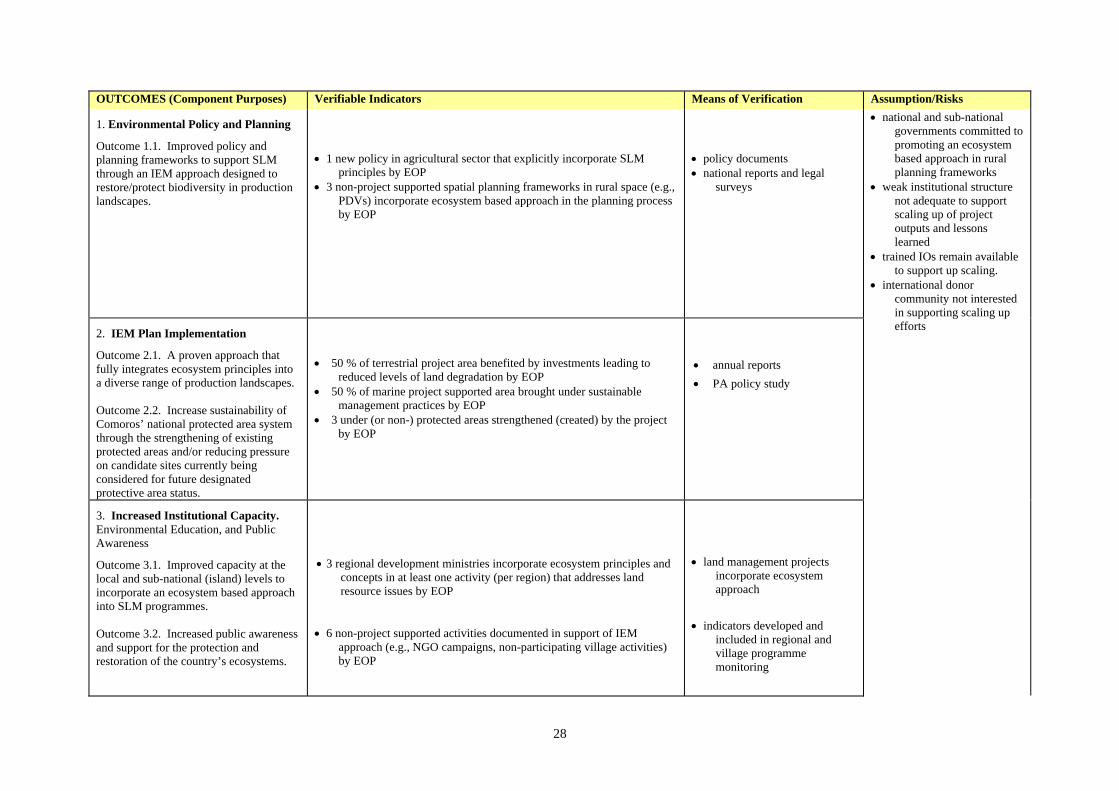
28
OUTCOMES (Component Purposes) Verifiable Indicators Means of Verification Assumption/Risks
1. Environmental Policy and Planning
Outcome 1.1. Improved policy and planning frameworks to support SLM through an IEM approach designed to restore/protect biodiversity in production landscapes.
• 1 new policy in agricultural sector that explicitly incorporate SLM
principles by EOP • 3 non-project supported spatial planning frameworks in rural space (e.g.,
PDVs) incorporate ecosystem based approach in the planning process by EOP
• policy documents • national reports and legal
surveys
2. IEM Plan Implementation
Outcome 2.1. A proven approach that fully integrates ecosystem principles into a diverse range of production landscapes. Outcome 2.2. Increase sustainability of Comoros’ national protected area system through the strengthening of existing protected areas and/or reducing pressure on candidate sites currently being considered for future designated protective area status.
• 50 % of terrestrial project area benefited by investments leading to
reduced levels of land degradation by EOP • 50 % of marine project supported area brought under sustainable
management practices by EOP • 3 under (or non-) protected areas strengthened (created) by the project
by EOP
• annual reports • PA policy study
3. Increased Institutional Capacity. Environmental Education, and Public Awareness
Outcome 3.1. Improved capacity at the local and sub-national (island) levels to incorporate an ecosystem based approach into SLM programmes. Outcome 3.2. Increased public awareness and support for the protection and restoration of the country’s ecosystems.
• 3 regional development ministries incorporate ecosystem principles and
concepts in at least one activity (per region) that addresses land resource issues by EOP
• 6 non-project supported activities documented in support of IEM
approach (e.g., NGO campaigns, non-participating village activities) by EOP
• land management projects
incorporate ecosystem approach
• indicators developed and
included in regional and village programme monitoring
• national and sub-national governments committed to promoting an ecosystem based approach in rural planning frameworks
• weak institutional structure not adequate to support scaling up of project outputs and lessons learned
• trained IOs remain available to support up scaling.
• international donor community not interested in supporting scaling up efforts

29
4. Project Management, M& E, and Information Dissemination
Outcome 4.1. An effectively managed project that achieves its stated objectives and serves as a useful model to support replication both in Comoros and elsewhere. Outcome 4.3. (i) increased awareness of the IEM approaches, results, and "lessons learned" derived from the Comoros' experience; and (ii) adoption of relevant experiences from this project by other SIDS in both the region and beyond.
• programme activities executed in a timely and cost-effective manner • 3000 “hits” on web page by EOP
• 60 visits by donor representatives and other interested international stakeholders to one or more project sites by EOP
• 1 new IEM initiative replicating Comoros approach in region by EOP
Component 1. Environmental Policy and Planning Outputs (Sub-Component Purposes) Verifiable Indicators Means of Verification Assumption/Risks
1.1. Policy Output 1.1. To create an enabling environment to support the development and adoption of an ecosystem approach in spatial planning processes in rural landscapes.
• 9 public fora supported for policy makers by EOP • 5 policy studies supported by EOP
• minutes of the meetings • study reports • participation in international
workshops/seminars
1.2. Planning Output 1.2. To develop community-led ecosystem management plans in coastal ecosystems.
• 6 IEM plans prepared by EOP
• IEM plans
Component 2: IEM Plan Implementation Outputs (Sub-Component Purposes) Verifiable Indicators Means of Verification 2.1 IEM sub-projects Output 2.1. Implementation of community –based projects identified and prioritized through the aforementioned IEM plans that will lead to the partial restoration of the ecosystem and the provision of environmental “goods and services”.
• 18 sub-projects implemented in support of IEM plan implementation by
EOP • 1660 ha of degraded land put under sustainable management
• approved sub-project proposals • project management reports • project M &E reports
• policy makers interested in participating in public fora and consider policy options
• village associations sharing a
bounded ecosystems are willing to work together to address issues of common interest
• government provides agreed
on counterpart funding • villagers provide needed
counterpart (in-kind) financing
• uncertain land tenure
situation may impede reaching agreement on critical IEM sub-projects
• PAs are not financially self-
sustainable within Life of Project (LOP)

30
2.2 Protected Areas Output 2.2 Strengthening of existing and creation of new protected areas leading to increases in the protection and conservation of biodiversity.
• 3 protected areas strengthened/created in proximity to IFAD project
areas by EOP
• PA management plans and
budgets • Project management reports • Project M &E reports
Component 3: Capacity Building, Environmental Education, and Public Awareness Outputs (Sub-Component Purposes) Verifiable Indicators Means of Verification 3.1. Capacity Building Output 3.1. National, sub-national (insular) and local stakeholder capacity strengthened to support future adoption and implementation of an ecological approach in rural spatial planning.
• 18 workshops by EOP • 18 short courses by EOP • 27 cross site visits by EOP • 3 training courses by EOP
• project management reports • project M &E reports
3.2. Environmental Education and Public Awareness Output 3.2. Increase levels of education and awareness among local communities, decision-makers, and the public at large of the significance of the country’s critical ecosystems and their role in providing “goods and services,” existing status and threats, and opportunities that exist to address the situation through incorporating SLM and biodiversity conservation principles and objectives into an ecosystem approach.
• 4 public school curricula developed by EOP • 9 (in aggregate) annual EA campaigns implemented in 3 regions (3 per
region) between PY 2 – PY4
• project management reports • project M &E reports
Component 4: Project Management, M&E and Information Dissemination Outputs (Sub-Component Purposes) Verifiable Indicators Means of Verification 4.1 Project Management Output 4.1 National coordination unit strengthened to manage and coordinate GEF-supported activities
• GEF activities partially integrated into Programme’s PTBA and M&E
system 6 months after Project approval and fully integrated into both in subsequent years
• GEF reporting requirements complied with in a timely and satisfactory matter
• project management reports • project M &E reports • GEF specific reporting
products

31
4.2. Monitoring and Evaluation Output 4.2 Three sub-national M&E units strengthened to supervise GEF supported activities.
• GEF required monitoring requirements integrated into IFAD M&E
system 6 months after Project approval • GEF reporting requirements complied within a timely and satisfactory
matter
• review of M&E system
parameters and data collection methodology
• Project monitoring and evaluation reports
4.3 Information Dissemination Output 4.3 An information dissemination strategy developed and implemented.
• information strategy prepared by end of PY 1 • media and their information outputs (e.g., webpage, brochures,
newsletter) by EOP
• strategy • media outputs

38
Appendix 2 - Budget
Comoros: Integrated Ecological Planning and Management in Coastal Ecosystems
I. Background and Assumptions Project Duration The GEF project is designed and has been costed for four years. The baseline studies, training and capacity building activities will take place throughout the project’s duration but are expected to occur mostly during the initial years. Taxes As is the practice with externally financed projects in Comoros, all goods are expected to be procured free of identifiable taxes and import duties. These are considered as part of the Government contribution to the project. Supervision costs: As the GEF component is an integral part of the National Sustainable Human Development Program, all fiduciary supervision costs will be covered by the NSHADP (not the GEF Grant) Project costs: Project cost by component, by expenditure account and the financial summary are provided below – full project COSTABs are annexed. Procurement: IFAD-financed procurement of goods and civil works and services will be undertaken in accordance with Government procedures to the extent that these are consistent with IFAD’s Procurement Guidelines. Contracts estimated to cost the equivalent of USD 22 000 or more will be awarded on the basis of local competitive bidding. Prudent shopping procedures on the basis of at least three quotations will apply to all contracts with an estimated cost below USD 22 000 equivalent. Disbursement: The grant will disburse over four-year period. Withdrawals from the grant account may be made against certified statements of expenditure in respect of eligible expenditures and in amounts as designated by IFAD. The relevant documentation justifying such expenditures will be retained by the project and made available for inspection by supervision missions and external auditors. All other withdrawals from the grant account will be made on the basis of full supporting documentation.

39
Table 1. Project Cost by Component/Sub-component
Component
Total (US $ ‘000)
% Total
A. Environmental Policy and Planning 1. Environmental Policy 2. Environmental Planning
Subtotal: Environmental Policy and Planning
77
430 507
2.7
14.9 17.6
B. IEM Plan Implementation 1. IEM sub-project investments 2. Protected Areas
Subtotal : IEM Plan Implementation
1,228
627 1,855
42.7 21.8 64.5
C. Institutional Capacity and Environmental Education and Public Awareness 1. Capacity building 2. Environmental Education and Public Awareness Subtotal: Institutional Capacity and Environmental Education and Public
Awareness
159 68
227
5.6 2.4 8.0
D. Project Management, M&E, Information Dissemination 1. Management 2. M&E & Information Dissemination
Subtotal: Project Management, M&E, Information Dissemination
188,8 95,2 284
6.6 3.3 9.9
Total Project Costs 2.872.000 100
Table 2. Financial Summary
Years Ending (US$ ' 000) 2008 2009 2010 2011 Total Total Project Costs
Total Investment Total Recurrent Costs
601 16
761 16
743 16
704 16
2,80864
Financing Sources GEF IFAD Disapora Government of Comoros Beneficiaries (in-kind)
231 286 58 20 20
276 377 77 25 24
250 378 86 23 22
243 355 80 21 21
1,0001,396
3008987
% of total project costs GEF IFAD Disapora Government of Comoros) Beneficiaries (in-kind)
8.0
10.0 2.1 0.7 0.7
9.6
13.1 2.7 0.9 0.9
8.7
13.2 3.0 0.8 0.8
8.5
12.4 2.8 0.7 0.7
34.848.710.63.13.1

40
Appendix 3 - Incremental Cost Analysis
Comoros: Integrated Ecological Planning and Management in Coastal
Ecosystems
Overview 1. The “Integrated Ecological Planning and Management in Coastal Ecosystems” Medium Size Project (MSP) is a “blended” project, fully integrated into the IFAD-supported National Sustainable Human Development Programme (NSHDP). The project goal is to address non-sustainable land use practices and concurrent loss of biodiversity through the development and adoption of an ecosystem based approach in Comoros' rural land use planning and development activities. Project objectives are to support community-led, ecological planning and the subsequent identification and implementation of field and related enabling activities designed to address priority natural resource use conflicts affecting ecosytem “health” and the provision of environmental “goods and services” contributing to losses in economic productivity and human well-being. The MSP has four project components: (i) Environmental Policy and Planning, (ii) IEM Plan Implementation, (iii) Increased Institutional Capacity and Environmental Awareness, and (iv) Project Management, M&E, and Information Dissemination. The MSP would support activities in up to six sites (two per island). Pilot sites would consist of one or more coastal watersheds or similar, well-defined bounded “ecosystems” where the IFAD Programme is targeting communities to develop and implement environmental restoration and sustainable natural resources management activities. Three of these six sites are also characterized by their proximity to existing/proposed national protected areas (PAs) whose future viability will depend on their inclusion in a broader spatial planning approach as described above. The project will also provide support to strengthening existing (or faciliating the creation of new) PAs under the IEM Plan Implementation component. 2. Activities that will be supported by GEF resources include: (i) mainstreaming successful elements of this approach into sub-national (insular) and national policy frameworks; (ii) increasing capacity to develop and implement IEM approaches at the local, sub-national and national levels; (iii) increasing public awareness and developing curricula in environmental education highlighting the IEM approach and benefits associated with its adoption; and (iv) environmental mapping and planning in the respective coastal ecosystem. Subsequent to ecological mapping followed by a community-based prioritization process, illustrative field activities selected to restore (at least partially) the ecosystem and associated “goods and services” include: (v) strengthening of existing and creation of new protected areas with emphasis on freashwater/coastal-near-shore marine ecosystem, (vi) mangrove restoration, (vii) reforestation with native species, (viii) planting of vegetative sedimentation barriers along river banks, (ix) provision of alternative livelihoods designed to reduce pressure on the natural resource base, and/or (x) pilot eco-marketing/green labeling activities directed at supporting ecologically sustainable ylang-ylang and/or other spice production. Final selection of these (or other) activities will be determined through a community led process leading to the preparation of the aforementioned site-specific ecosystem map and plan. 3. The principal project outputs will be: (i) public dialogue fora, field visits, and policy studies targeting senior policy makers; (ii) up to six IEM plans leading to at least partial restoration of a “healthy” ecosystems; (iii) priority investments in support of plan implementation; (iv) activities to facilitate the declaration (or strengthening of existing) protected areas; (v) support for increasing institutional capacity in support of IEM; and (vi) the design and implementation of public awareness strategies and curricula development for village schools. 4. The principal project outcomes will be: (i) the establishment of improved policy and planning frameworks to support both the adoption of SLM principles and the restoration/protection of biodiversity in production landscapes through an IEM approach; (ii) a proven approach that fully

41
integrates ecosystem principles into a diverse range of production landscapes; (iii) increased sustainability of Comoros’ national protected area system through the strengthening of existing protected areas and/or reducing pressure on candidate sites currently being considered for future designated protective area status; (iv) improved capacity at the local and sub-national levels to encompass an ecosystem based approach into SLM programmes, (v) increased acceptance of more environmentally-sustainable practices in the rural space and greater public awareness of the ecological, economic and social significance of the Comoros islands’ environment; and (vi) empowerment of local communities and increased effectiveness in participation in local management decisions. 5. Projected global environmental benefits include: (i) a reduction and possible reversal of current trends in land degradation through supporting sustainable land management (SLM) policies and practices that generate global environmental benefits; and (ii) the conservation and sustainable use of biodiversity and the maintenance of the ecosystem goods and services that biodiversity provides to society. 6. Likely national environmental benefits include: (i) increased capacity in rural institutions; (ii) improved management of the natural resource base on which agriculture depends at the village level; (iii) provision of an enabling policy environment that will facilitate the development and future adoption of an IEM approach through policy change; (iv) improvements in life quality and human welfare; (v) field interventions that will lead to at least a partial rehabilitation of the natural resource base and in turn improvements in life quality and human welfare; (vi) reduction in natural resource use conflicts affecting livelihoods (e.g., reduction in downstream sedimentation that adversely affect coral reefs used for fishing); (v) increased inter-village collaboration/cooperation needed to address issues of common concern; (vi) increased local, sub-national and national awareness on status of the country’s ecosystems and the role IEM planning and management plays in addressing selected critical environmental issues; (vii) strengthen education of the next generation on the importance and socio-economic significance of the country’s ecosystems; (viii) improved programme management skills to support an ecosystem-based approach; (ix) an M & E system broadened to include bio-physical parameters; and (x) an information dissemination system that increases awareness in the Comoros of the benefits on an ecosystem based approach to environmental issues of national concern. 7. The GEF Alternative will achieve these objectives at a total incremental cost of US$ 2.9 million (M) with contingencies, with a proposed GEF contribution of US$ 1 M and co-financing of US$ 1.9 M from IFAD, Government, project beneficiaries and the Diaspora. Background 8. The Comoros archipelago is comprised of four main islands located North of the Mozambican channel between Madagascar and the African continent (for the purpose of the MSP the following analysis is limited to the islands that comprise the Union of the Comoros). The three islands (Grand Comore, Anjouan, and Moheli), are characterized by high topographic relief and radial drainage associated with their volcanic origins. The Comoros insular shelf area (to the 200 meter isobath) measures an estimated 900 km2. Recent population projections (2005) estimate a national population of approximately 800,000 inhabitating a total land area of 1,826 km2, equivalent to 438 persons per km2. The national economy is dominated by agriculture of which the major exports are vanilla, ylang-ylang and cloves. The country’s fisheries remains largely artesanal in nature though offshore the resources are thought to be under-exploited and represent a major source of future potential growth. Agriculture is the most important sector, providing employment for 70 % of the population and accounting for 40% of GNP. It is estimated that an additional 100 000 Comorians are living abroad (mostly in France). Remittances from abroad and international assistance play an important role in the national economy and for financing rural investments, and represent a significant positive inflow for the country’s balance of payments.

42
9. The major threats to the Comoros environment are: (i) deforestation and conversion of forest lands;5 (ii) accelerlated soil erosion; (iii) the effects of downstream sedimentation contributing to the loss of critical coastal and nearshore marine habitats (coral reefs, marine grassbeds and mangroves); and (iv) non-sustainable fishing practices (e.g., dynamite fishing and “gleaning” of emergent reefs) and its affects of the fishery resources and associated habitat. 10. Major root causes associated with the aforementioned threats are: (i) poverty, (ii) population pressure, and (iii) lack of suitable alternatives to reduce pressures on the islands' limited natural resources. 11. The critical barriers that impede resolving these threats and underlying root causes include: (i) a weak institutional base to address environmental issues, (ii) lack of a recognized institutional planning framework that promotes an integrated approach to address environmental issues that cut across sectors, (iii) lack of awareness among rural communities of the importance of maintaining a heathly environment in supporting their livelihoods, and (iv) identifying and promoting new technological approaches that reduce the non-sustainable pressures on the terrestrial and coastal/marine environments while serving to increase human well-being. 12. To date, IFAD has financed four loan operations in The Comoros for a total commitment of US $ 11.8 million; all projects are closed, with the most recent occurring in December 2004. These projects have been guided by IFAD’s strategy for Comoros as described in the Fund’s Country Strategy for Operations (COSOP) in April 2002. The strategy which remains current is focused on raising agricultural productivity to address rural poverty based on recognition of the sector’s role as the principal livelihood activity of the rural poor. Nevertheless, in recognition that human activities are increasingly contributing to the degradation of natural resources, the latter which remain the basis for agricultural and other rural productive activities, future IFAD programmes will focus increasingly on linking activities aimed at improving the lot of the rural poor with measures to safeguard the environment. IFAD’s fifth project in the Comoros, the National Sustainable Human Development Programme (Programme National de Développement Humain Durable), is the first initiative to reflect this shift in focus. Baseline Scenario 13. The focus of IFAD’s fifth and newly approved loan, the National Sustainable Human Development Programme (NSHDP) is to address land degradation and loss of biodiversity in the marine and forest ecosystems. The development objective of the Programme is to put in place a community-based management system and promote the sustainable development of natural capital to ensue that participating communities will benefit through an increase in agricultural productivity which in turn will permit an increase in revenue, food security and household conditions. The Programme’s short term objective is to promote growth in poor, rural household revenues and the mitigation of their physical environment and conditions of life. This would be achieved through meeting the following intermediate objectives: (i) reinforcement of community and professional rural based organizations; (ii) intensification of agricultural production (feeding material, milk production), rational natural resources management (soils, forest, fish), and increased value chains associated with agricultural production; (iii) promotion of the participation of disadvantaged groups in production activities; and (iv) increasing the role of and contributions from the diaspora in support of local economic development projects. 14. The actions on the ground will be determined primarily by existing local land management associations (asociations de gestion des terroirs); these groups will be responsible for the implementation of much of the project activities and represent a key element on which the Programme will focus its capacity building activities. The Programme will support interventions in 2 regions per
5 At present there is only an estimated 30 % of the original forest area left and what remains can only be found at higher elevations (above 400 meters).

43
island which were selected based on the application of socio-economic criteria. 6 The Programme’s design included the following basic principles: (i) demand driven by the local communities, (ii) internalization of the decision-making process, (iii) decentralization of management actives and financial resources, and (iv) the contracting out of many of the proposed interventions (see Appendix for more detail on the IFAD Programme). 15. The calculation of the MSP Baseline was based on an evaluation of the relevant components which will be supported under the IFAD National Sustainable Human Development Programme. Once identified, they were evaluated to the sub-component/activity level and compared with components of the proposed MSP. For more detail on each of the components/sub-components, see Attachment 1. 16. The IFAD supported Programme has four components and 9 sub-components (see Table 1).
Table 1. Components/sub-components and Key Activities supported under the National Sustainable Human Development Programme
Component/sub-component Key activities
Component 1. Reinforcement of capacity of the concerned parties 1.A. Reinforcement of the institutional framework and capacity of the operators
- rehabilitation of Agricultural Centers - workshops, training, technical support and studies
1.B. Support to village associations - updating baseline studies - support to village land management associations - identification and restoration of degraded sites - creation of land management associations - development of spatial management plans - support to organized producer and intermediary groups - support for communal authorities - communication, information and education
Component 2. Rehabilitation of the environment and sustainable management of the village land (terroirs)
2. A. Protection of the environment and productive capital
- application of soil conservation technologies - diffusion of the embocagement approach - development of agroforestry planting materials - technical support - reforestation
2. B Intensification of the vegetative production and amelioration of the animal production
- vegetative production improvement - diffusion of fruiticulture planting materials - adaptive research - training - improved animal production
2. C. Security of tenure - workshops, cadastres, title devolution 2. D. Sustainable management of marine resources
- promote organization and training of fishermen - environmental consciousness raising
- community projects and equipment purchase - access to credit for boat purchase
Component 3. Support services to local initiatives 3. A. Actions of community economic interest
- small-scale rural development projects
Component 4. Coordination and management of the project 4.A Programme coordination unit - creation of national management unit 4.B Regional project supervision cells - 3 M&E cells created
6 Criteria include mobilization of community contributions, land tenure security, promotion of economic activities among the female population, etc.

44
Summary Baseline Costs and Benefits 17. Baseline Costs. The main activities supported under the baseline scenario are infrastructure rehabilitation (agricultural centers), contracts to Intermediary Organizations (IOs) to support the community-led implementation of many of the field activities, investments in support of intensification of agricultural and animal production, assistance to support small-scale enterprise activities, and public discussions, studies, and possible assistance to support a pilot land titling activity (see Attachment 2a). The estimated costs of baseline activities amount to US $ 4.4 M (see Matrix 1). Funding sources contributing to the baseline are the IFAD loan, government contributions, local participants and the Diaspora. Government contribution to the baseline is an estimated 5 % and is used primarily to cover central and field staff salaries. The remaining estimated 95 % of the baseline costs are financed by IFAD and the beneficiaries/disapora. 18. Baseline Benefits. Activities under the Baseline Scenario will produce predominantly national benefits in the form of intensifying agricultural and livestock production complemented with support for increasing and diversifying small-scale rural enterprises. Together, these investments should contribute significantly to increasing rural household income and economic well-being. It is hoped, that through such an approach, the baseline would contribute to achieving some global benefits through a reduction of pressure on the ecosystem and loss of biodiversity. These benefits would likely be derived from the baseline’s activities supporting any shift away from extensive land use in project sites, a pattern characterized by non-sustainable production practices and/or their utilization in fragile lands not suitable for this type of production system. 19. In the absence of additional GEF funding, the implementation of the aforementioned baseline set of activities is unlikely to contribute in any significant way to achieving global environmental benefits. GEF Alternative 20. The GEF Alternative will support the long-term restoration of up to 6 pilot coastal ecosystems through the development and implementation of integrated ecosystem management plans. Supporting the aforementioned, predominately field activities, will be a number of institutional interventions designed to create an enabling environment to ensure the long-term sustainability of the pilot sites and increase the chances for their future replication. Financing the incremental costs associated with the Alternative would build on the Baseline Scenario by: (i) supporting the strengthening of existing (and development of new) village-based land management plans; (ii) building on these land management plans by supporting collaborative approaches among villages sharing common bounded areas to develop Integrated Ecosystem Management plans designed to identify and prioritize critical interventions that would lead to the eventual restoration of the degraded landscape, underlying natural processes, and the environmental “goods and services” they provide; (iii) support for the implementation of village and ecosystem level plans; (iv) increasing capacity among village associations, intermediary operators, NGOs, producer associations, local and sub-national government technicians to develop and implement an IEM approach to land degradation (to include the identification and inclusion where appropriate, relevant technologies such as soil and water conservation, d’embocagement, and other principles characteristic of SLM); (v) support for the establishment of new policy frameworks to foster replication of the approach supported under the Alternative and ensure future sustainability; (vi) creating of new and/or strengthening of existing PAs in support of Comoros National PA System; (vii) increasing public awareness of the significance of the country’s ecosystems and the role they play in contributing to life quality and human well-being; and (viii) fostering the promotion and dissemination of project initiatives, results and impacts through printed and electronic media, as well as national and regional workshops and seminars.
21. Costs. The total cost of the GEF Alternative is estimated to be US $ 7.3 million (M) (GEF financing: US $ 1.0 M), detailed as follows: (i) US $ 507 thousand (K) (GEF financing: US $ 241 K)

45
to support the Environmental Policy and Planning component; (ii) US $ 4.5 M (GEF financing: US $ 457 K) to support IEM Plan Implementation; (iii) US $ 896 K (GEF financing: US $ 145K) to support Increased Institutional Capacity, Environmental Education and Public Awareness and (iv) US $ 1.4 M in support of Project Management, M&E, and Information Dissemination (GEF financing: US $ 100 K). 22. Benefits. Under the GEF Alternative, the Union of the Comoros would be able to undertake a challenging program encompassing both national and global benefits. It would not only serve to increase the livelihoods and well-being of those families and groups in rural communities most at risk but lead to improved ecological “health” and the restoration of the underlying processes and environmental “goods and services” that would benefit the broader rural population. Benefits generated from this comprehensive approach would include both national benefits (e.g., improved management of the natural resource base and reductions in natural resource use conflicts affecting rural livelihoods) as well as global benefits. Global benefits include: (i) reduction in and restoration of degraded landscapes, underlying natural processes and the global “environmental “goods and services” they provide and (ii) conservation and sustainable use of the biodiversity of global importance (see complete list of national benefits in the Incremental Cost Matrix below). Incremental Costs7 23. The difference between the costs of the Baseline Scenario (US $ 4.4 M) and the GEF Alternative (US $ 7.3 M) is an estimated US $ 2.9 M (including physical and price contingencies). The matrix below summarizes the baseline and incremental expenditures during the four year Programme period. Co-financing of US $ 1.9 M of the US $ 2.9 M of increment has been mobilized as follows: (i) US $ 89 K from the Government (in cash); (ii) about US $ 1.4 M from IFAD; and (iii) US $ 87 K from the local beneficiaries (in-kind) and the US $ 301 K from the Diaspora. The total requested GEF contribution amounts to US$ 1 M. Out of this total an estimated: (i) US$ 241 K would support the Environmental Policy and Planning component; (ii) US $ 457 K for IEM Plan Implementation; (iii) US $ 145 K in support of Increased Institutional Capacity, Environmental Education and Public Awareness; and (iv) US $95.2 to support M&E and information dissemination and US $ 100 K to support Project Management. The aforementioned GEF-support would cover incremental costs of investments and equipment, technical assistance, training, workshops and other services such as public awareness media campaigns
7 Kindly note minor differences in totals are due to rounding error and the amounts include in contingencies.

46
Matrix 1. Incremental Cost Matrix
Component Cost Category
US$ Million
Domestic Benefit
Global Benefit
Comp 1. Environmental Policy and Planning
Baseline US$ 0.00 M - NA - - NA -
With GEF Alternative
US$ 0.51 M (i) supports increased capacity in rural institutions, (ii) the development of village management plans to promote sustainable management of the natural resource base on which agriculture depends at the village level, (iii) provides and enabling environment that will facilitate the development and future adoption of an IEM approach through policy change, and (iv) development of ecosystem-based plans that when implemented will lead to improve life quality and human welfare.
(i) provides an enabling policy environment complemented with ecosystem-based management plans that will ensure the sustainability of the Alternative supported interventions and accompanying benefits and their future replication that will lead to (ii) the reduction/restoration of degraded landscapes, underlying natural processes and the global “environmental “goods and services” they provide and (iii) the conservation and sustainable use of the biodiversity of global importance.
Incremental US$ 0.51 M
Note: Consists of: GEF (US$ 241 K); IFAD (US$ 218 K); Government (US$ 24 K);and the local beneficiaries (US$ 24K).
Comp 2. Integrated Ecosystem Planning and Management
Baseline US$ 2.61 M (i) reductions/restoration of degraded lands in IFAD project sites (SDIs); (ii) more efficient grassland, vegetable, and livestock production systems; (iii) small –scale revenue generating activities; (iv) increased and diversified household income; (v) reductions in uncertainty associated with land security; and (vi) reductions in pressure on coastal fish stocks, increases in access to under utilized offshore fish stocks, and reductions in loss/spoiling of fish catch.
(i) limited reductions in pressure on existing/candidate protected areas in proximity to IFAD sites, (ii) on-site treatment of land degradation, and (iii) reductions in loss of marine biodiversity.
With GEF Alternative
US$ 4.46 M (i) series of strategic field interventions identified through a participatory approach in the IEM plan preparation process that will lead to rehabilitation of the natural resource base and in turn improvements in life quality and human welfare, (ii) reduction in natural resource use conflicts affecting livelihoods (e.g., reduction in downstream sedimentation that adversely affect coral reefs used for fishing), (iii) increases in inter-village collaboration/cooperation needed to address issues of common concern.
(i) reductions/restoration of degraded landscapes, underlying natural processes and the global “environmental “goods and services” they provide and (ii) conservation and sustainable use of the biodiversity of global importance
Incremental US$ 1.85 M Note: Consists of: GEF (US$ 457 K); IFAD (US$ 1,033 K); Government (US$ 44 K); Diaspora (US$ 276 K); and the local beneficiaries (US$ 43 K).

47
Component Cost Category
US$ Million
Domestic Benefit
Global Benefit
Comp 3. Capacity Building, Environmental Education and Public Awareness
Baseline US$ 0.67 M (i) establishment of a permanent management and support system in the agricultural sector through the rehabilitation of local centers of agricultural management and providing support for local meetings and workshops of agricultural stakeholders, field schools, technical assistance and special studies.
limited global benefit achieved through (i) increased awareness among participating villages of the importance of applying SLM (e.g. (d’embocagement) and equivalent principles in sustainable fisheries management needed to restore their surrounding ecosystem.
With GEF Alternative
US$ 0.90 M
(i) strengthen local and sub-national capacity to support the sustainable development and management of coastal ecological landscapes focusing on promoting collaborative efforts in villages sharing common ecosystem; (ii) increasing local, sub-national and national awareness on status of the country’s ecosystems and the role IEM planning and management plays in addressing selected critical environmental issues; and (iii) educating the next generation on the importance and socio-economic significance of the country’s ecosystems
(i) increased institutional capacity and (ii) public awareness and support for ecosystem-based management approaches leading to reduction/restoration of degraded landscapes, underlying natural processes and the global “environmental “goods and services” they provide and the conservation and sustainable use of the biodiversity of global importance.
Incremental US$ 0.23 M Note: Consists of: GEF (US$ 145 K); IFAD (US$ 52 K); Government (US$ 15 K); and the local beneficiaries (US$ 5 K).
Comp 4. Project Management, Coordination, M & E and Information Dissemination
Baseline US$ 1.14 M
(i) development of sufficient management capacity and accompanying M & E programme ensuring cost-effective implementation of the baseline project.
Limited global benefit
With GEF Alternative
US$ 1.42 M (i) improved programme management skills to support an ecosystem-based approach; (ii) monitoring and evaluation system broadened to include bio-physical parameters; and (iii) an information dissemination system that increases awareness in the Comoros of the benefits on an ecosystem based approach to environmental issues of national concern.
(i) increased Programme management capacity to manage ecosystem-based approaches to address land degradation and loss of biodiversity leading to restoration of degraded landscapes and slowing/reversal of loss of biodiversity; (ii) an M&E system that includes parameters that measure global benefits and support monitoring of GEF’s SOs; and (iii) an information dissemination system that will facilitate the adoption of relevant experiences and “lessons learned” from the project in other SIDS in the region and beyond.
Incremental US$ 0.28 M Note: Consists of: GEF (US$ 157.9 K); IFAD (US$ 60 K); Government (US$ 57.1 K) and beneficiaries (US$ 5 K)
Totals Baseline US$ 4.42 M
With GEF Alternative
US$ 7.29 M
Incremental US$ 2.87 M Note: Consists of: GEF (US$ 1 M); IFAD (US$ 1.40 M); Government (US$ 87 K; Diaspora (US$ 304 K); and the local beneficiaries (US$ 86 K).

48
Attachment 1: Brief Description of IFAD’s National Sustainable Human Development Programme Components and Activities
Component 1. Reinforcement of the Institutional Framework and Capacity of the Operators. The objective of the component is to support and strengthen existing community structures established by earlier projects/programmes working in the priority IFAD sites. The component has two sub-components: (i) reinforcement of the institutional framework and capacity of operators, and (ii) support to village associations. The objective of the first sub-component is to put in place a permanent framework and based on providing consultative support to the relevant stakeholders in the rural sector including the government, producer groups and their associations, NGOs and other operators. Major activities include the rehabilitation of existing Agricultural Centers, financing workshops and meetings, training, particularly through field schools, technical support and studies. Under the second sub-component, the objective is to reinforce the governance at the local and community levels in such a way as to support sound management of village lands and support the consolidation of rural community structures particularly village development associations, groups of producers, beneficiaries, producer groups etc. Support will include: (i) updating baseline studies; (ii) support to village land management associations (gestion des terroirs) and their associated village development associations (preparation and awareness raising), training and reinforcement in the capacities of the associations; (iii) identification of degraded sites (Intensive Development Sites or IDS) which will be restored through the application of appropriate technological “packages;” (iv) creation of associations of territory management and development of terroir management plans; (e) support to organized producer groups; (f) reinforcement of intermediate organizations; (g) support for communal authorities; and (h) communication, information and education (workshops) meetings, media dissemination, web site, etc. Component 2. Protection of the Environment The environmental protection component has 4 sub-components: (i) protection of the productive capital in priority sites, (ii) intensification of vegetative production and amelioration of animal production, (iii) security of land tenure, and (iv) sustainable marine resources management. Programme activities supported under the protection of environment and productive capital sub-component will address: (i) soil conservation technologies to combat erosion on the previous selected Intensive Development Sites (IDS), (ii) diffusion of embocagement approach, (iii) the development of agroforestry and multiplication and distribution of forestry and shrubs planting material), (iv) development of planting material and promotion of cultivation techniques, (v) technical support to groups of local producers and (vi) support for local initiatives in reforestation and production of forest resources. Intensification of the vegetal production and amelioration of the animal production sub-component will focus on: (i) diffusion of the technologies in support of vegetative production (using natural fertilizer, improved planting materials, phytosantiary production, etc.); (ii) diffusion of fruiticulture planting materials; (iii) adaptive research directed at improved agricultural techniques; and (iv) training. Improved animal production will focus on improved animal health, increase in production (and quality) of milk and meat production. The security of tenure sub-component will support a pilot programme during the first 3 years of the Programme and define subsequent actions through providing support for workshops, cadastres, and devolution of titles. The objectives of the sustainable management of marine resources sub-component are to diminish the pressure on the actual coastal demersal and pelagic fishery resources and aid the small-scale fisherman

49
to increase access to the still, largely under-exploited oceanic fish stocks. The main activities supported under the sub-component will be to: (i) organize fishermen and provide training in fishery techniques (e.g., the conservation and transformation of fish products), management of common equipment, and environmental consciousness raising; (ii) support community projects and purchase of equipment (e.g., refrigerators and conservation equipment, transport, and Fish Aggregating Devices); and (iii) access to lines of credit to purchase boasts and equipment. Component 3. Support from the Diaspora for Local Initiatives There are some 150,000 – 200,000 Comoronians that live in France. It is estimated that they transfer some US $ 60 million in remittances each year to the country. The objectives of the third component are to: (i) facilitate the transfer of these funds through supporting increase security and efficiency in their transfer, (ii) increase the productive use of these funds through investment, and (iii) promote a more active engagement of the members of the disapora in support of the rural development in the Comoros. Small-scale economic agricultural and rural economics would be supported through projects generated by the participating villages. Component activities would support the transfer of funds, facilitate access to credit, increase coordination and support to local project initiatives, and monitoring. Component 4. Coordination and Management of the Programme The final component is coordination and management of the Programme. A national management unit would be created at the level of the Union composed of a national coordinator supported by an accountant, an M&E specialist and administrative staff. M&E cells will also be created and integrated into each of the three island’s respective ministers responsible for agriculture. Overall policy guidance would be the responsibility of a national policy committee (pilotage). IFAD would be responsible for direct supervision of the Programme.

51
Appendix 4. Sector Context
Comoros: Integrated Ecological Planning and Management in Coastal
Ecosystems
Bio-physical Characteristics 24. Located north of the Mozambican channel between Madagascar and the African continent, the Comoros archipelago, is comprised of four main islands Grande Comore, Anjouan, Mohéli, and Mayotte (for purposes of the proposed project the latter island which is under French jurisdiction, will not be discussed further). All the islands are volcanic in origin. Grand Comore is the largest of the three islands with a surface area of 1,011 km2. The relief of the island is dominated by two large mountain massifs divided by a central plateau (Mbadjini). These are Karthala (2,361 m) in the south whose dome extends to cover some 2/3rd of the island and La Grille (1,087 m) to the north. In contrast, Anjouan (424 km2) is characterized by a much more rugged and mountainous topography, steep slopes, narrow valleys and a highly crenulated coastline. The highest mountains are Ntrinki (1,595 m) and Trindrini (1,474 m). Mohéli, the smallest of the three islands with a surface area of 190 km2, is less elevated than the other two islands whose highest point is Mzékukulé (790 m); Mohéli’s other major topographic feature is the relatively large Djandra plateau with an average elevation of 350 m. 25. The archipelago is characterized by a tropical maritime climate with two distinct seasons; a rainy season from October to April associated with northerly winds bringing moist warm air from the Indian Ocean into the region (kashkazi) and a cool and less humid season typically occurring from May to October (kusi). Rainfall and temperature vary from island to island with greater rainfall recorded in the higher elevations. There is a wide range of rainfall dependent on altitude and exposure between 1,500 and 5,000 mm. 26. Soils are volcanic in origin whose specific properties depend on their geological age and succession. Anjouan is the oldest geologically of the three islands with fertile soils but that have proved to be highly sensitive to erosion. In contrast Grande Comore is the youngest of the three islands soils have been grouped into three classes varying in their fertility. 27. The three islands are characterized by radial drainage due to their high topographic relief and volcanic origins. 28. In general, the natural vegetation has been described as similar to that of Madagascar. In the lowland areas in proximity to the bases of the islands’ volcanoes, ground cover is either sparse herbaceous vegetation typical of lava flows and cinder fields or an Indo-Pacific scrub. Forest cover at these elevations (up to 1,800 m) historically was an evergreen moist broadleaf forest but most lowland forests have long since disappeared in all three islands.8 At higher elevations, forest cover consists of stands of giant heath (Phillipia comorensis). The largest remaining highland forests occur in Grand Comore and Mohéli but even these forests are highly degraded occurring mainly at the higher elevations on the slopes of Mt. Karthala (Grand Comore). In Anjouan, there is only an estimated 10 km2 of forest remaining on the island. The main cause for habitat loss is agricultural expansion. Underlying causal factors and constraints are population growth, poverty and land scarcity. 29. Of the estimated 2,000 native plant species found in the islands, (including 175 ferns and 72 species of orchids), approximately 33 % are thought to be endemic to the Comoros. Nevertheless, it is
8 The tropical and sub-tropical moist broadleaf forests of the Comoros represents one of World Wildlife Fund's (WWF) 200 most significant global biomes.

52
believed a number of plant species have already become extinct due to the disappearance of much of the islands’ forest habitat. 30. While the species richness of the fauna is relatively low it is thought to be higher than most other Indian Ocean islands. Among mammalian vertebrates there are 8 native species consisting of fruit bats (3 sp.), insectivore bats (3 sp), and lemurs (2 sp). Among the reptiles there are 25 native terrestrial species and two species of sea turtles (green and the hawksbill). Among birdlife there are a relative high proportion of endemics (21 species). Species threatened due to habitat destruction include Livingstone’s fruit bat (Pteropus livingstonii) and several bird species such as the scops owl (Otus capnodes). 31. Conservation of the remaining forested areas particularly on Mt. Karthala (Grande Comore), Mt. Ntringui (Anjouan) and Mt. Koukoule (Mohéli) is viewed as a priority due to the need to protect many of the remaining endemic species.9 32. Mangroves in general are poorly developed in the archipelago. Where they occur the largest stands tend to be found on the southern coasts of the islands (e.g., Mbeni and Matulay in Mohéli) which are more protected from the “kashkazi” or northerly winds. The four main species are Rhizophora micromata, Avicennia marina, Bruguerra gymnorgiza, and Lumnitzera racemosa. 33. Due to their biological distinctiveness, the country’s coastal ecosystems have been identified as one of the world's 43 marine priority regions.10 Despite the occurrence of four species of marine turtles in Comoros waters only two, the green turtle (Chelonia mydas) and Hawksbill turtle (Eretmochelys imbricata) are known to nest on the country’s beaches. Mohéli is commonly cited and one of the most important islands for nesting sites in the southwestern Indian Ocean (some 89 beaches have provided evidence of breeding).11 Critical sites include Itsamia and Nyumashiura. Other major breeding sites are Bimbini, Moya, and Miriotsi. Major threats to beaches come in the form of extraction of sand and coral for construction aggregate. The main threats to nesting females and their eggs include: habitat destruction (sand and coral extraction for construction material), poaching, and feral animals (e.g., dogs). 34. Coral reefs in the archipelago are dominated by fringing reefs varying in percentage surrounding the three islands from 60% (Grande Comore) to nearly 100% (Mohéli). The total areal extent of fringing reefs is an estimated 11000 ha.12 Many of these reefs were heavily impacted due to a “bleaching” event associated with the global rise in surface sea temperature in 1998. 13 However, there appears to be some evidence of regeneration in some corals since then.14 Recovery appears to have been greatest at sites located the most remotely from both human pressures and/or protected from the affects associated with the southerly trade winds. 35. Primary threats to the reefs include: non-sustainable fishing practices (e.g., dynamite fishing, poorly placed anchors, and small-mesh fishnets), coral extraction, gleaning of emergent reefs, and sedimentation associated with non-sustainable land use practices.
9 WWF: Wildworld Profiles: Comoros Forests. 10 The Comoros has been identified as one of the 43 marine priority ecoregions within the WWF for Nature’s Global 200 conservation prioity list. 11 Estimates from the year 2000 indicate that there are some 6,000 egg laying females on the island of Moheli of which some 3,000 utilize the five beaches in and around Itsamia which have been identified as among the top 10 nesting beaches worldwide for green sea turtles See IUCN, 2002. 2002 Red list status assessment. Maritime Turtle Specialist Group, Species Survival Commission, Red List Program. 12 Fatouma, A.A., Bicarima, A., and Ahamada, S. 2000. Report on the state of management of protected marine areas in Comoros. UNEP-Unit for Regional Coordination for East African Region. 13 In Comoros, this global event was cited as a contributory cause leading to almost 50 % die-off. See Status of Coral Reefs in the South West Indian Ocean Island Node. 14 For example in a field assessment of the Moheli Marine Park in 2002 documented corol re-growth from 20 – 50%. See EUCARE Comoros 2002. Edinburgh University Coral Awareness and Research Expeditions.

53
36. At present there are just 2 protected areas in the country, Lake Dziani Boudouni (a RAMSAR wetlands site) and the Moheli Marine Protected Area. There continues to be preparatory work in creating a Coelacanth marine park (south coast of Grande Comore) and the Karthala National Park (Grande Comore). Population 37. The population is estimated to be 575,660 inhabitants of whom some 72 % live in rural areas (Table 1). The annual increase in population is an estimated average of 2.1 % in the last years with an average density of 309/km2 though there are strong differences between the islands.
Table 1. Selected Population Parameters in the Comoros
Island Total Population Rural Population Rate of Growth Density/km2 Anjouan 243,732 173,921 2.1 574.8 Mohéli 35,751 16,170 3.3 123.3 Grande Comore 296,177 224,704 2 258.2
Total 575,600 414,432 2.1 309.3 38. The country is one of the poorest countries in Africa and is classified as the 132 nd among all countries with an IDH index of .547 (2005). Since 1995, the economy has largely been stagnant and the quality of life has deteriorated significantly and poverty increased. The percentage of unemployment is an estimated 13 %. 39. The rapid increase in growth of the country’s population together with the high incidence of poverty and dependence on primary resources are commonly regarded as the greatest threats to Comoros natural resources and biodiversity. Economy 40. The economy of the Comoros is heavily dominated by the agricultural sector occupying some 70 % of the population and representing some 41 % of the gross national product. Agriculture is mostly subsistence in nature and highly dependent on the direct use of natural resources and biodiversity though there are three major cash crops (ylang ylang, vanilla and cloves). Despite the importance of the sector, the country is not self-sufficient in foodstuffs and the government has to import an estimated 60 % of the country’s basic food needs. Institutions and Policy National Development Strategy and Planning. 41. The overall planning framework and strategy for the Comoros is set out in the Growth and Reduction in Poverty Strategy Document (Document Stratégie de croissance et de réduction de la pauvreté) or DSCRP. This strategy, which was prepared with the assistance of UNDP in 2002, was succeeded by and interim update used for a multi-lateral donor consultation in 2005. One of the principal themes running through the document was giving central priority to the needs of the rural poor within the broader framework of the fight against poverty. Among other actions, the promotion of agricultural development was identified as an essential means to augment the revenue of the rural population and reduce poverty. The strategy had 7 principal axes: (i) create the conditions of sustainable economic development, (ii) boost the role of the private sector, (iii) reinforce governance and justice, (iv) mitigate the state of heath of the population, (v) promote the education and professional formation and thus the general improvement of human capital, (vi) promote a healthy environment and guarantee sustainable development, and (vii) promote the security and the fight against terrorism.

54
42. Complementing this strategy is the 2006 – 2009 Action Plan (10 October, 2005) which identified 35 priority programmes in need of support over that period of time. Following a similar approach to the aforementioned Strategy, these programmes were grouped by Sector. The most relevant axes to the proposed GEF MSP are to: (i) create conditions for sustainable economic development (Axe stratégique 1), (ii) promote a greater role for the private sector in priority sectors including agriculture, fish, and livestock (Axe stratégique 2) and (iii) promote a clean environment and ensure the sustainability of development (Axe stratégique 6). Selected Actions identified to implement these programs emphasize in particular those environmental issues that affect economic activity that have a direct affect on the quality of life and sanitary conditions of the population (Table 2).
Table 2. GEF MSP Relevant Actions in SCRP for Period 2006 - 2009
Axe Programme Objectives Actions Create conditions for sustainable economic development (#1)
Ensure the provision of low cost energy (2.1.2)
- increase energy efficiency and substitution of fuel wood
- rationale utilization of fuel woods - reduction of deforestation and preservation of vegetative cover - contribution to the utilization of appropriate energy
Relaunching the private sector in critical economic sectors (# 2): Tourism Sector
Support for tourism development (2.2.4.1)
- put into practice the valorisation and promotion of products
- Karthala volcano - support to the MPA Moheli - Promote agro-tourism (including agricultural rural production)
Promote a healthy environment and guarantee the sustainability of development. (# 6)
Conservation of natural resources and development of activities based on the richness of the flora and fauna of Comoros. (2.6.2.2)
- put in place a network of terrestrial and marine protected areas representative of the natural patrimony of the Comoros and support for co-management with communities - development of economic activities compatible with the objectives of conservation of protected areas
- delimitation and put into place plans of co-management at 5 sites - elaboration of provisional management plans at 5 sites - study for the evaluation of potential economic activities of substitution - reinforce capacity of individual and groups to manage lucrative activities in support of sustainable management of natural resources - put in place sustainable financing.
Put in practice a policy of integrated management of coastal zones (2.6.3.3)
- promote utilization of locally available materials that do not threaten ecosystems
- evaluation of available and usability of substitute construction materials - promote the development of substitutions for construction materials - identify incentives to promote consumption of

55
- put in place measures that address the pollution of coastal ecosystems
substitution materials - sensitization of the local population of the importance and respect for the deposit of wastes
Maintain soil fertility, restoration of degraded soils and sustainable management of forest resources 2.6.5.5)
- sustainable management of forest resources - support activities protection and management of vulnerable sites
- identification of vulnerable sites to agricultural expansion - develop a regiment to protect sites - support activities on management and protection of vulnerable sites.
43. These national policies are in conformity with the country’s stated Millennia Development Goals (MDGs). Specifically, under MDG Objective # 7 (Ensure a sustainable environment), the main priorities are to: (i) integrate the principles of sustainable development in the nation’s policies, and (ii) reverse the on-going trend in the loss of environmental resources. Agricultural Sector 44. The Ministry of Production and Environment (MPE) has the mandate for planning, programming and the monitoring and evaluation of development actions in the domain of agriculture, fish and environment. It is composed of four general directorates: Environment, Agriculture and Rural Development, Fisheries and the National Institute of Research on Agriculture, Fisheries and Environment (INRAPE). These “national” directorates are represented by regional offices in each island. It is these regional offices that are responsible for the policy, programming, legislation, and regulations, M&E and execution. 45. It was in the late 1960s that national decision makers in the Comoros first became aware and concerned about the degradation of lands and the disappearance of national forests. However, it was not until the early 1990s that a firm response in the form of a major study was forthcoming. The study, completed by the Agricultural Production Development Bureau, identified that one of the agricultural sector’s principle objectives should be to include the rationale and sustainable exploitation of natural resources. The Study noted the linkage between deforestation, degradation of soils, and the negative consequences on insular hydrology. To meet these challenges, a number of measures were identified including better articulation of agriculture and the environment, gestion des terroirs, increasing environmental consciousness training and professional formation, and support for biological methods that exclude the use of agro-chemicals. Policy issues that needed to be addressed to achieve the objective of sustainable agriculture included: (i) land tenure that will permit the security of agricultural exploitation that is an essential condition to investment, natural community based management of natural resources and the constitution of protected areas, (ii) regularization of cultivated parcels of land under forest cover, (iii) delimitation of massif forests relics and their classification as protected areas supported by eco-development zones in their periphery. The document also supported the preservation of the island’s biodiversity for its benefits in medicinal plants, plants perfume, and tropical fruits. 46. Comoros’ national agricultural policy was last reviewed in 2001 and subsequently confirmed through a national workshop in November 2001. The main objective of the policy remains to develop and support favourable conditions to augment revenue of the small farmer. Among other actions, these include: safeguarding the country’s natural resource base.

56
Environmental Sector 47. The Directorate of Environment of MOPE is the lead government agency responsible for the environment. Similarly to MOPE itself, the Directorate has official institutional counterparts in each of the three islands. At the local level, community-based organizations are the main means of development planning and implementation. In the early 90s, environmental associations (Ulanga or associations in the defence of the environment) first appeared and remain to this day working in a diverse range of environmental issues including health, water, environmental consciousness raising, tree planting, etc. In each island there is a federation of Ulanga which represents that island’s village environmental associations. 48. In 1993 the Council of Ministers adopted a National Environment Policy (PNE) and Environmental Action Plan (PAE). The main goal of the PNE is the integration of the environment dimension in the policy and the socio-economic development of the country. The primary objective of the PNE is the “rational management of the natural and cultural patrimony for the well-being of the Comorian people and their future generations.” It is defined along 3 axes: (i) rational management, (ii) safeguarding and protection, and (iii) conservation and or restoration of natural resources. Key relevant priority activities include: (i) safeguarding and protecting biological diversity in the zones of greater interest both ecologically and culturally, with specific priority given to the safeguarding of the terrestrial and marine biodiversity); (ii) realization in the short term, effective protection in the zones of highest ecological interest, (iii) identification of new sites to preserve and/or manage; (iv) promoting an agriculture that is both economically and ecologically viable with specific objectives of promoting the integration of environmental aspects into national agricultural policy; (v) putting in place appropriate management of the country’s marine and coastal space. Under Program 5 (conservation and valorisation of the national patrimony), specific priorities relevant to the present GEF MPS include: (i) the National Park of Mohéli, (ii) Karthala and other reserves, and (iii) research in seeking out alternative solutions leading to a reduction of pressure on the country natural resources (e.g., fuel wood). 49. Policy on environment is based in the framework law on the environment adopted in 1994. In the same year, the Government, with assistance from the UNDP, adopted a Declaration on Sustainable Development. 50. By signing the Convention on Biodiversity in Rio in 1992 and ratifying it in 1994, Comoros agreed to safeguard the environment and the associated natural ecosystems and their species and habitats. With the support of UNDP, the country developed a National Strategy on Biodiversity and Strategic Action Plan in 2000. 51. There exist a number of key themes identified in the Strategy. One theme was the integration of the biodiversity and sustainable management dimensions into the country’s policy and sector strategies. Key issues included: (i) urbanism and pollution and the effect on the coastal near shore marine environment; and (ii) erosion and impoverishment of soils in part due to absence of relevant decrees with the environmental framework law. The proposed objective and measures include: (i) revision of the existing policies in the domain of agriculture, forestry, tourism and urbanization (ii) examining how to mainstream biodiversity into said policies; and (iii) mainstreaming biodiversity into other sector policies for water, energy, and fisheries (where policies don’t presently exist). 52. Comoros’ National Biodiversity Action Plan also identified priority ecosystems and natural habitats to protect.15 These included: highland forests (Karthala and Forêt de la Grille), savannas,
15 These were determined by meeting one or more of the following criteria: (i) rich biodiversity supporting a number of endemic and/or threatened species, (ii) support for migratory species, (iii) areas characterized by special soils, geology, scientific and/or cultural importance, (iv) unique representativeness or associations with a process of evolution or other biologically essential processes.

57
grasslands, crater lakes (e.g., le Lac-Dziani-Boundouni), lacustrine ecosystems, beach systems, mangroves, rocky coasts, islets and coral banks and reefs and sea grasses. 53. To address issues primarily associated with land degradation, the Comoros launched the National Action Plan (PAN) in 2004. The PAN is based on five axes. These are: (i) the fight against soil degradation (management of watersheds), (ii) reforestation, (iii) land tenure security, (iv) protection of water sources, and (v) seeking alternatives to the use of wood for energy. 54. Comoros’s recently completed (2006) National Action Programme for Adaptation to Climate Change (NAPA) highlighted the need to integrate adaptation efforts into the process of national planning. Specific priorities identified in the NAPA are the need for: (i) public information and education on climate risks; (ii) capacity-building (media, civil society associations for education on climate change; (iii) identification and strengthening of stakeholders to promote the integration of the climate dimension in the development policies and research institutes; (iv) updating of the cadastre and reforms of the judicial framework; (v) establishing a database on climate parameters; and (vi) support to the social and economic database, particularly the generation of social and economic digital maps of the Commissariat General for Planning. 55. The NAPA also recognized the need for combining the adaptation agenda with a communication strategy based on available data on current and the future climate variability. This strategy would address the climate issue from an explicit perspective on how climate change will affect the poor in terms of health and livelihoods and the way it increases their vulnerability. IFAD Project 56. There are few other countries that have as close and direct relationship between the environment and the economy as the Comoros. Increased population growth and density together with widespread poverty have combined to contribute to a reduction of agricultural production and over exploitation of agricultural lands and forests. These pressures and constraints have rendered inadequate the traditional models of exploitation of natural resources. Fragile lands not appropriate for agricultural production are increasing being put into production all year long. Few forests still exist most have now been relegated to relict stands and even these are commonly being affected by under-story production systems (e.g., banana, tarot and cattle grazing). Deforestation and clearing of the under story contribute to an increase in erosion and downstream sedimentation. Landless or land poor members of the population increasingly are turning to the exploitation of coastal resources and in the absence of sound management practices are also contributing to degradation of such highly productive habitats as mangroves, coral reefs, and marine grass beds. A major source of deforestation is exploitation of wood resource needed for use in the distillation of the ylang ylang flowers. The exploitation of wood has accelerated in recent years with the introduction of power saws. One underlying source of environmental degradation is insecurity of land tenure. Land tenure insecurity contributes to land degradation through: (i) short term contracts between owners and users offering few incentives to invest in long-term sustainable land protection, and (ii) illegal occupation of lands of the state which serve to contribute to deforestation and conversion into another production system. 57. To date, IFAD has financed four loan operations in the Comoros. The focus of IFAD’s fifth and newly approved loan, the National Sustainable Human Development Programme, is to address land degradation and loss of biodiversity in the marine and forest ecosystems. The development objective of the Programme is to put in place a community-based management system and promote the sustainable development of natural capital to ensue that participating communities will benefit through an increase in agricultural productivity which in turn will permit an increase in revenue, food security and household conditions. The short term objective is to promote growth in poor, rural household revenues and the mitigation of their physical environment and conditions of life. This would be achieved through the meeting the following intermediate objectives: (i) reinforcement of community and professional rural based organizations; (ii) intensification of agricultural production (feeding material, milk production), rational natural resources management (soils, forest, fish),

58
increased value chains associated with agricultural production; (iii) promotion of the participation of disadvantaged groups in production activities; and (iv) increasing the role of and contributions from the Diaspora in support of local economic development projects. 58. The IFAD supported Programme has four components and 9 sub-components (see Table 3).
Table 3. Components/sub-components and Key Activities supported under the National Sustainable Human Development Programme
Component/sub-component Key activities
Component 1. Reinforcement of capacity of the concerned parties 1.A. Reinforcement of the institutional framework and capacity of the operators
- rehabilitation of Agricultural Centres - workshops, training, technical support and studies.
1.B. Support to village associations - updating baseline studies - support to village land management associations - identification and restoration of degraded sites - creation of land management associations - development of spatial management plans - support to organized producer and intermediary groups - support for communal authorities - communication, information and education
Component 2. Rehabilitation of the environment and sustainable management of the village land (terroirs) 2. A. Protection of the environment and productive capital
- application of soil conservation technologies - diffusion of the embocagement approach - development of agroforestry planting materials - technical support - reforestation.
2. B Intensification of the vegetative production and amelioration of the animal production
- vegetative production improvement - diffusion of fruiticulture planting materials - adaptive research - training - improved animal production
2. C. Security of tenure - workshops, cadastres, title devolution 2. D. Sustainable management of marine resources
- promote organization and training of fishermen - - environmental consciousness raising - community projects and equipment purchase - access to credit for boat purchase
Component 3. Support services to local initiatives 3. A. Actions of community economic interest
- small-scale rural development projects
Component 4. Coordination and management of the project 4.A Programme coordination unit - creation of national management unit 4.B Regional project supervision cells - 3 M&E cells created 59. For more detail on each of the components/sub-components see Attachment 1 in Appendix 3. 60. The Programme will support interventions in 2 regions per island which were selected based on the application of socio-economic criteria. Specifically, sites were selected on their meeting some or all of the following criteria: (i) presence and concentration of pockets of poverty, (ii) presence and significance of the environmental problems, (iii) the need to reinforce the dynamic of intensification in the poverty zone, (iv) degree of mobilization and cohesion of the communities, (v) the existence of protected zones (actual or future), and (vi) the inexistence of agricultural development programmes focusing on the intensification of agriculture. These sites have been described in more detail in Tables 4 and 5 below.

59
Table 4. IFAD Project Sites, Characteristics and Rationale for Selection
Village Zones Selected Characteristics Rationale for Selection
Anjouan Haut Nyumakele poor zone and strong demographic
pressure strong dynamic of agricultural
intensification previous support by IFAD many other donor project in earlier
years number of producer groups precarious housing
strong population density elevated incidence of poverty strong erosion susceptibility
reinforcement of earlier IFAD support work
Bas Nyumakele impoverished zone previous support by IFAD relative dry zone (only supports
one growing season) high percentage of degraded lands
(> 50 %) number of foreign donor projects
strong population density elevated incidence of monetary
poverty strong erosion susceptibility extension of IFAD supported
expertise
Presqu’île de Bimbini high degree of poverty fishing communities practicing
non-sustainable fishing practices presence of degraded lands (> 50 %
of parcels) existence of large land holdings little donor presence in recent years
elevated poverty necessity to preserve the marine
and terrestrial environment presence of a marine park synergy with possible
environmental activities land tenure problems
Mohéli Côté côtiere partial overlap with drainage basin
of MPA Mohéli rural poverty high levels of deforestation degraded lands and accelerated soil
erosion large number of landless strong community organization high agricultural potential coral die-off associated with
sedimentation Plateau du Djando high presence of degraded lands
water deficient area high agricultural potential high levels of rural poverty precarious housing landless
source of water advance degradation in forests and
high sensitivity to erosion biodiversity resources and potential
tourism
Grande Comore Hamahamet isolated villages
threatened forests high agricultural potential high incidence of poverty water deficit area
Mbadjini forest threatened land tenure issues experience in embocagement potential for milk production strong population density water access in the high zones.

60
Table 5. Total and Target Group Population in IFAD Project Sites
Island Project Sites No of Villages
Population (2003) Target Population
Family Units
Anjouan Nyumakelé & Sima 31 68,183 26,182 11,982 Mohéli Djandro (plateau and
low zones) 7 5,898 2,229 1,065
Grande Comore
Mbadjini, Hamahamet, and surrounding area
17 24,529 8,659 3,415
Total 55 98,610 37,070 16,462 61. The actions on the ground will be determined primarily by existing local land management associations (asociations de gestion des terroirs); these groups will be responsible for the implementation of much of the project activities and represent a key element on which the Programme will focus its capacity building activities. For more detail on project organization and implementation see Appendix 5. 62. The IFAD project provides an excellent opportunity to integrate a GEF-supported activity designed to address the combined issues of sustainable land management (SLM) and the conservation of biodiversity within and integrated ecosystem management (IEM) framework. Some of the advantages to blending a GEF activity into recently approved IFAD Programme include the following: (i) first, IFAD has a long and successful experience working in Comoros; (ii) the fifth and newest Programme will address issues of land degradation and marine resources through promoting more intensive and/or alternative sustainable production systems working at the village level; (iii) sites have been previously identified and to a large degree, provide a sound basis to achieve global (as well as national) benefits; and finally, (iv) institutional arrangements to implement the Programme, based on many years of prior experience, will be in place and provide the basis for fast and efficient launching of any new activity.

61
Appendix 5 - Detailed Project Description
Comoros: Integrated Ecological Planning and Management in Coastal Ecosystems
Project Goal and Objectives 63. The project goal of the proposed “Integrated Ecological Planning and Management in Coastal Ecosystems” Medium Size Project (MSP) is to address non-sustainable land use practices and concurrent loss of biodiversity through the development and adoption of an ecosystem based approach in Comoros' rural land use policy, planning and development activities. Project objectives are to support community-led, ecological planning and the subsequent identification and implementation of field and related enabling activities designed to address priority natural resource use conflicts affecting ecosystem “health” and the provision of environmental “goods and services” contributing to losses in economic productivity and human well-being. Global environmental objectives are: (i) to reduce and possibly reverse current trends in land degradation through supporting sustainable land management (SLM) policies and practices that generate global environmental benefits; and (ii) the conservation and sustainable use of biodiversity and the maintenance of the ecosystem goods and services that biodiversity provides to society. Project Components and Activities 64. The proposed MSP has four project components: (i) Environmental Policy and Planning; (ii) IEM Plan Implementation; (iii) Increased Institutional Capacity, Environmental Education and Public Awareness; and (iv) Project Management, M&E, and Information Dissemination. Environmental Policy and Planning Component 65. The Environmental Policy and Planning component has two sub-components. These are respectively, the Environmental Policy and Planning sub-components. 66. The main objective (output) of the environmental policy sub-component is to create an enabling environment to support the development and adoption of an ecosystem based approach including the “mainstreaming” of sustainable land management (SLM) and environmental principles generally and the conservation of biodiversity specifically in policy formulation and spatial planning processes affecting Comoros' rural landscapes. This will be achieved primarily through providing support for: (i) public fora to facilitate dialogue with senior policy makers, (ii) travel for policy makers to visit field sites where IEM Plans have been prepared and are under implementation, and (iii) a series of policy studies (e.g., participatory development communication strategy, environmental "goods and services" and financial sustainability of protected area systems) among others to support more informed policy formulation. 67. Specifically, senior policy makers in the national and regional (insular) development, economy & finance, and production, fishing and agriculture ministries would be targeted and invited to participate in a series of public fora to include representatives from the private sector, environmental NGOs, civil society. The objective of these fora would be to observe, discuss and evaluate the results, experience, and “lessons-learned” to date derived from project supported activities and assess their relevance to public policy formulation with respect to principles in IEM, SLM and conservation of biodiversity and their significance to rural development. A total of 9 public fora beginning in project year (PY) 2 (2009) are proposed. 68. Similarly, a series of inter-island site visits will be supported to facilitate the comparative evaluation of project activities in differing land/seascapes. A total of 18 cross-site visits are included (each visit consists of 1 person visiting all project sites on the three islands over a 6 day period).

62
69. Finally, a series of studies would be supported under this sub-component to address critical data gaps that serve as constraints to achieving improved policy formulation in the environmental and natural resources sectors. A total of 5 studies have been projected over the life of the project (LOP). Three have already been identified as priorities. The first study which would be initiated a priori to the others would support an analysis and subsequent development of a participatory communications strategy to facilitate increased communications between local communities and decision makers. The other studies identified as priorities are: (i) assessing and quantifying in monetary terms the environmental “goods and services” provided in the project supported “ecosystems” (including “income” foregone attributable to existing environmental status of the sites) and investigating how best to implement a “Reward for Environmental Services (RES)” scheme (or similar such approaches) that provide incentives to local communities to adopt ecologically suitable land use practices; and (ii) examining relevant alternatives that may be applicable to Comoro’s nascent protected area system to generate revenues to at least partially offset administrative and management costs. Both studies have been identified as actions under the SCRP.16 The remaining studies will be determined following consultations with the communities in PY 1. These could include: (i) the relationship between land tenure and sustainable land use practices, (ii) development of environmental “health” indicators appropriate for monitoring, and (iii) the role and significance of intensive production models (e.g., embocagement) in restoring ecosystem processes and functions. 70. The objective of the component’s environmental planning sub-component is to develop community-led ecosystem management plans for specific coastal ecosystems. The objective of these community – led plans and the underlying processes leading to their development would be to: (i) delimit spatially inter-village areas shared between two or more villages that for project purposes would serve as an ecosystem (they can be defined by physical, political, and/or legal boundaries or a combination there-of); (ii) identify and agree on the major environmental issues and underlying causal factors and constraints that need to be addressed for their resolution; and (iii) agree on a prioritized series of actions needed to resolve these issues and contributing to the eventual restoration of the ecosystem. 71. Specifically, activities in support of plan development would include: (i) sensitization and training of the local communities; (ii) facilitating reaching consensus on the existing significance of the ecosystem (including provision of environmental "goods and services"); (iii) determining the status of the present and projected future “rehabilitated” ecosystem (to include mapping); and (iv) identifying priority interventions leading to a “restored” ecosystem. This process would be integrated into and build on the complementary IFAD supported activities working through Village Development Associations (AVD) including preparation and awareness raising, training and reinforcement in the capacities of the associations and the development of terroir management plans (see Attachment 1 of Appendix 3 for more detail). 72. One IEM plan will be developed per site to include up to 6 sites (2 per island). These sites, which to varying degrees would overlap with areas supported under the IFAD Programme, are: (i) Sima-Bimbini and Nyumakele (Anjouan); (ii) Itsamia-Lac Dziani-Boundouni-Hamavouna and Djando (Mohéli); and (iii) Hamaharnet and Mbadjini (Grande Comore). Three of the aforementioned six sites would be associated with an existing or proposed future protected area (see below). 73. Key outputs would include: (i) guidelines to be used as reference to identify, prepare, and implement GEF-supported investment sub-projects (an illustrative draft of possible guidelines has been included in Attachment 1); (ii) baseline studies to include a baseline map (the existing situation);
16 See relaunching the private sector in critical economic sectors (Axe # 2): Tourism Sector and promoting a healthy environment and guarantee the sustainability of development (Axe # 6).

63
and (iii) a draft IEM plan (an agreed on plan which represents what the communities feel is a rehabilitated “healthy” ecosystem supported by priority investments). 74. The main outcome of the environmental policy and planning component is to facilitate the establishment of improved policy and planning frameworks to support SLM through an IEM approach designed to restore/protect biodiversity in production landscapes. 75. The component’s objectives, outputs and outcomes support several of Comoros’ existing policy objectives and proposed actions. The Government of Comoros (GOC) has identified the integration of environmental principles in the country’s development planning process and sector development plans as a high priority. Under Millennia Development Goal (MDG) Objective # 7 (to ensure a sustainable environment) a priority action for the Comoros is to integrate the principles of sustainable development in the nation’s policies. Similarly, a key area and supporting action identified under the National Environment Policy (PNE) and National Action Plan (PAE) respectively are promoting the integration of environmental aspects into national agricultural policy. The importance of this priority is underscored further in the country’s National Biodiversity Strategy (SNB) which identified the following key actions: (i) the revision of the existing policies in the domain of agriculture, forestry, tourism and urbanization; (ii) examining how to mainstream biodiversity into said policies; and (iii) mainstreaming biodiversity into other sector policies for water, energy, and fisheries as key actions (see Table 1). IEM Plan Implementation and Protected Areas Component 76. Under the IEM plan implementation component there will be two sub-components: (i) IEM Plan Implementation, and (ii) Protected Areas. Under the former sub-component, resources will be used to support specific priority interventions leading to the eventual restoration of processes and functions in ecosystems previously identified, delimited, and agreed to under the Project’s environmental planning sub-component. As noted above, site specific priorities will be identified through a community led process leading to the preparation of an ecosystem management plan developed under sub-component 1.2. Where more than one village community shares an ecosystem (e.g., a watershed), the project would facilitate collaborative efforts between villages to develop a coherent approach to address system-wide issues of common concern. 77. Examples of possible sub-component investments that could complement IFAD investments during the implementation of the IEM plan include: (i) reforestation activities with indigenous species; (ii) mangrove restoration and management; (iii) strategies in support of the sustainable harvesting of emergent reefs; (iv) development of small-scale alternative livelihoods designed to reduce pressure on the pilot site’s natural resource base (e.g., non-forest products, medicinal herbs); (v) pilot eco-marketing/green (bio) labeling activities; (vi) pilot activities in support of ecologically sustainable ylang-ylang production; (vii) community based efforts to address solid waste disposal; and (viii) applied ecological studies. Specific investments will be determined through the community consultation and formulation process described above. However, investment profiles have been prepared to illustrate in more detail the nature of activities supported under this component (Attachment 2). 78. Under the Protected Areas sub-component, three of the aforementioned six sites would be associated with existing or proposed future protected areas. These are: (i) Forêt La Grille (Grande Comoros), (ii) Lac Dziani Boundouni (Mohéli), and (iii) Bimbini – Ile de la Selle Zone (Anjouan). Criteria used to select these sites included: (i) degree to which they overlapped with the IFAD project sites, (ii) their importance in contributing to the conserving and protection of biodiversity, (iii) degree of threat and the potential for the blended project to support activities that contribute to a reduction of pressure on natural resources in and around the PA, and (iv) the absence of likely alternative donor assistance to support the proposed site. See Attachment 3a - 3c for more detail on these sites.

64
79. In addition to activities designed to address threats to the integrity of the protected areas through supporting economic activities in surrounding villages, under the PA sub-component there would be additional activities designed to strengthen the existing or support the creation of new PAs. Likely interventions include: (i) support to facilitate the legal declaration of new PAs, (ii) the preparation of (or updating of existing) management plans, (iii) boundary demarcation, and (iv) promotion of co-management approaches with direct participation by local communities. Where investments in infrastructure and equipment are thought to be financially sustainable (determined through the management plan process), these will also be supported (infrastructure would be small-scale in nature and likely limited to trails, interpretative signs, small, visitor centers (kiosk-like), and/or boundary demarcation. 80. Lessons learned from a previously funded GEF project in support of the Mohéli Marine Park have shown that: (i) empowerment of local communities is critical to the creation and management of protected areas due to weak government enforcement; (ii) networking among villages and facilitating communication to address inter-village conflicts over natural resource utilization (e.g., conflicts between fishing and non-sustainable land use and its downstream impacts) is important to achieve the desired outcome; and (iii) project design must take into account and adjust for a data poor environment and limited government resources. These factors contribute to the conclusion that community co-management approaches to the management of natural resources and protected areas is the only viable solution in the Comoros.17 Similarly, the establishment of inter-village committees under the MSP would build on and take into account the in the establishment of the regional marine park for the Coelacanth.18 These and other “lessons” have been included in the design of the MSP through the recommendation to apply a series of “benchmarks” to ensure their adoption in the development and implementation of this sub-component. For illustrative purposes, an example has been included in Attachment 4. These will be finalized within 6 months of the approval of the MSP. 81. In at least two IFAD sites, Mbadjini (Grande Comore) and Boundouni-Hamavouna (Mohéli) there is likely to be forthcoming donor support for existing/proposed protected areas that are in proximity to project sites. These are Forét du Kartala (World Bank) and the Mohéli Marine Park (Indian Ocean Commission). If confirmed, the IFAD PCU will work closely with their respective counterparts to ensure that the respective IFAD project supported activities are complementary and increase chances of achieving a “win-win” situation where both biodiversity conservation and reduction of rural poverty can be mutually achieved. 82. The main outcomes of the component are: (i) a proven approach that fully integrates ecosystem principles into a diverse range of production landscapes; and (ii) increased sustainability of Comoros’ national protected area system through the strengthening of existing protected areas and/or reducing pressure on candidate sites currently being considered for future designated protective area status. 83. These outcomes directly support key actions called for under the SCRP for the Period 2006 – 2009. Specifically Programme 2.6.2.2 and 2.6.5.5 of Axe #6 (to promote a healthy environment and guarantee the sustainability of development). Under the former programme priority actions include: (i) to put in place a network of terrestrial and marine protected areas representative of the natural patrimony of the Comoros; (ii) provide support for the adoption of co-management approaches involving local communities; and (iii) delimit specific sites followed by the implementation of co-management plans at 5 sites. Moreover, additional actions identified under the same programme would promote the development of economic activities compatible with the objectives of conservation of protected areas. Other relevant policy actions identified to support the aforementioned programme include: (i) assessments to evaluate the potential for alternative economic activities for surrounding
17 Granek, E.F., and Brown, M.A., 2005. Co-management Approach to Marine Conservation in Mohéli, Comoros Islands. Conservation Biology 1724-1732. 18 In this project which will be established in the south west of Grande Comore to protect the Coelacanth, inter-village committees were established in support of park objectives.

65
communities, (ii) reinforcement of the capacity of individuals and/or groups to manage economic activities that support principles of the sustainable management of natural resources and (iii) putting in place sustainable financing. 84. Under the latter programme (Programme 2.6.5.5), key actions include: the maintenance of soil fertility, restoration of degraded soils and sustainable management of forest resources with the following objectives: (i) sustainable management of forest resources, (ii) support for activities that lead to the protection and management of vulnerable sites and support the following actions - identification of vulnerable sites to agricultural expansion, develop a regimen to protect sites and support activities on management and protection of vulnerable sites. Institutional Capacity and Environmental Education, and Public Awareness Component 85. The Institutional Capacity and Environmental Education, and Public Awareness component has two sub-components. These are the Institutional Capacity and Environmental Education, and Public Awareness sub-components. 86. The main objective of the capacity building sub-component is to increase capacity among project stakeholders at the level of the village “lead” and environmental associations (Ulanga), local (mayor’s office), regional (island) and national government and NGOs to support the development and inclusion of environmental planning and management principles in rural-based economic development. Under this sub-component, the project would finance the following: technical assistance, the development of one or more training modules, equipment and materials, workshops, short-courses, and cross-site field-visits. 87. Specifically, training modules and supporting materials would be developed and equipment purchased to support short courses designed to address specific environmental issues faced by the participating villages within the context of the broader ecosystem. Illustrative examples of thematic modules include: (i) the consequences of unplanned solid waste disposal, (ii) unsustainable land use practices and its affects on erosion and down-stream impacts, and (iii) destructive fishing practices including gleaning of emergent reefs. The identification of the modules will be finalized following consultations with the communities. Unlike the training modules which will target villagers, support for workshops and short-courses under this sub-component would target professionals and technicians in the relevant main-line agencies and focus on demonstrating the benefits of integration of SLM and biodiversity conservation principles into rural development through an IEM approach. Cross-site visits would focus primarily on targeting non-participating communities to expose interested leaders and producers of the benefits of adopting an IEM approach in pilot sites. 88. The expected outcomes of this sub-component are: (i) increased awareness among institutions and individuals responsible for rural-based economic development planning of ecosystem processes and functions and how the latter are affected by human interventions; (ii) empowerment of local communities and increased effectiveness in participation in local management decisions affecting their natural resources and environment; and (iii) improved capacity to work across disciplinary lines among NGO and public officers responsible for rural development planning and implementation. 89. This directly supports the 4th axe of the SCRP, (to promote the education and professional formation and thus the general improvement of human capital) as well as - reinforce capacity of individual and groups to manage economic activities in support of sustainable management, a priority action identified under SCRP 2006-2009 Action Plan (Programme 2.6.2.2: Conservation of natural resources and development of activities based on the richness of the flora and fauna of Comoros). This sub-component will also support training and capacity building directed at screening climate change risks and that adaptation responses and their incorporation into the local planning process. 90. The objective of the public awareness sub-component is to increase awareness among local communities, decision makers and the public at large of the options that exist to achieve an improved

66
environment and the benefits that would accrue from life quality and associated livelihoods. Under this sub-component, the Project could support the design and implementation of public awareness strategies and curricula development for village schools. 91. Specifically, under this sub-component the MSP would support the design of island-wide environmental awareness campaigns to increase awareness of the significance of the Comoros environment, highlighting its role in supporting rural livelihoods, the existing status, and current threats. Each campaign would be guided by the development a priori of a public awareness strategy that would be prepared with the assistance of technical consultants. In the preparation of these island-specific strategies, the consultants would assess what are the most cost-efficient means to increase public awareness stratified by target group (e.g., radio, newspapers and other print media, television spots, the use of “jingles” etc.). Campaigns would be supported annually through LOP. Under this sub-component, primary and secondary school curricula would be developed and integrated into interested schools within the project area. A core curriculum would be developed and supported with complementary materials that focus on specific ecological themes relevant to both the immediate area and the Comoros generally. If deemed successful, it is expected that these would be eventually ‘mainstreamed” into the national educational curricula. Given the relevance of climate change to the Comoros this topic will be incorporated into the sub-component. 92. The expected outcomes of this sub-component include increased acceptance of more environmentally-sustainable practices in the rural space and greater public awareness of the ecological, economic and social significance of the Comoros islands’ environment. This supports another SCRP priority action included under Programme 2.6.2.2, the sensitization of the local population of the importance and respect for the [the environment generally] and deposit of wastes specifically. Project Management, M&E, and Information Dissemination Component 93. Under this component, there are three sub-components. These are the Project Management, M&E and Information Dissemination. 94. As part of a “blended” operation, the management sub-component would be integrated into the overall Programme’s management structure (see below). The main outcomes would be a project implemented in a timely and efficient manner. 95. Under the MSP’s monitoring and evaluation sub-component, indicators developed during project preparation would be integrated into the programme’s M&E system. Specific outputs are: (i) an M&E plan consistent with IFAD and GEF requirements, and (ii) timely M&E reports conforming to GEF and IFAD requirements. For more detail on the MSP’s M&E plan see Appendix 6. 96. The Project’s information dissemination sub-component will support the dissemination of project results aimed at sharing “lessons learned” with project beneficiaries and with other individuals and institutions involved with the development and application of an IEM approach to address land degradation and biodiversity conservation issues in Small Island Developing States (SIDS). This would be done through providing support for conferences, publications and a homepage. The main expected outcomes are: (i) increased public support for the development and adoption of IEM approaches in the planning and management of rural space in SIDS; and (ii) adoption of relevant experiences from this project by SIDS in the region and beyond. 97. The proposed MSP will be a “blended” project, fully integrated into the IFAD supported NSHDP. It is proposed that the MSP would be implemented over a 4 year period (rather than the more typical three years. This is felt justified due to the weak institutional structure and low absorptive capacity of local communities. The US$ 1 million grant would be matched by an estimated US$ 1.9 million in co-financing as required by GEF. At present, it is felt that selected activities supported under the IFAD Programme could be used to meet this requirement divided among the loan,

67
and government and beneficiary counterpart contributions. The GEF component will be an integral part of the NSHDP as reflected in the following project organizational chart.

61
Organizational chart of the NSHDP – The GEF MSP will be an integral part of the program
Union des Comores Ministère de l Agriculture, de la Pêche et de l’Environnement
Unité Nationale de Coordination du Programme National
Coordinateur National
ANJOUAN URSP + CRPP
Unité Régionale de Suivi du Programme
MOHELI URSP + CRPP
Unité Régionale de Suivi du Programme
Grande Comore URCP + CRPP
Unité Régionale de Suivi du Programme
Structures villageoises Secteur Privé AVD GE AGT OP
Org. Intermédiaires.
CCA
CCA
CCA
C N P
crpp
crpp
crpp
Commissariat Général du Plan Collecte et fourniture informations statistiques
Coordination Stratégie nationale réduction pauvreté
CNP= Comité National de Pilotage CRPP= Comité Régional de Pilotage du Programme CCA = Centre de coordination Agricole AVD = Associations Villageoises de développement AGT= Associations de Gestion des Terroirs OP = Organisations Professionnelles
61
“Blending” with IFAD Activities 98. As noted previously, it is proposed that the GEF supported MSP will be fully “blended” into the IFAD Programme. There exist a number of opportunities to produce synergies to this approach. Some of these have been detailed below. Component Activities 99. In general, the main complementarities between the MSP and IFAD Programme can be broken down into the following categories: policy. The GEF MSP supports activities designed to promote more informed decision-making with respect to incorporating the environmental dimension in rural development through support for public fora, cross-site visits and studies. The IFAD project does not have an explicit policy activity. scale of planning and implementation. The focus on the IFAD Programme is at the village level. The GEF MSP complements this by focusing on the larger ecosystem within which one or more IFAD supported villages exist. The project team will ensure that planning, budgeting and administrative modalities are fully coordinated between the loan and the GEF grant. This will be further ensured by adopting the same procedures, lines of authority, accounting, procurement and monitoring modalities. Joint annual work program and budgeting exercises will ensure proper coordination of activities. The Program Coordination Unit based in Moroni under the supervision of the Ministry of Agriculture, Fisheries and Environment will be responsible of the general management aspects of the program (the IFAD loan and the GEF component). The PCU will ensure day-to-day management of the loan and the GEF component as well as the overall M&E function. The PCU will have two cells: (i) administrative and financial cell and (ii) M&E cell. The PCU will:
a) Manage financial operations centralise disbursement requests and ensure effective and rapid transfer of resources to the three regional units;
b) Compile all PTBAs (AWPB) for the three regional units, ensure that interventions and annual reports are compatible and well coordinated;
c) Organise technical assistance and ensure that demand from the three regions are met (including demand for training); and
d) Undertake international bidding and international/external technical assistance The PTBA (AWPB) preparation will be the process by which the program implementation units will prepare their respective planned actions and define an implementation monitoring plan. The preparation of the overall PTBA will incorporate the PTBAs for the three islands and the PCU. This will be coordinated under the supervision of the PCU coordinator. The PTBA of each island will be prepared by the regional M&E unit in consultation with all stakeholders through participatory annual planning workshops. The PTBA will be analyzed by the concerned CRCP. The PTBA (including GEF activities) will have to include detailed description of expected activities, the implementation modalities, timing and costs (unit and total costs) as well as the proposed monitoring indicators. The overall PTBA will be consolidated and monitored by the PCU. types of activities supported. The focus of the IFAD Programme is primarily on the promoting more sustainable production systems in the 1o natural resource sectors (agriculture, livestock, and fisheries). The GEF MSP complements this in supporting other activities within the ecosystem affecting ecosystem processes and functions as well as human well-being that are outside the scope of the Programme (e.g., solid waste disposal).
62
protected areas. IFAD activities in support of protected area strengthening (or establishment) is primarily focused on non-sustainable livelihoods in lands adjacent to the PA (e.g., illegal grazing of livestock). The GEF MSP will also support activities inside the PA (e.g., management plan preparation, zoning, minimal infrastructure investment and equipment). supporting activities. Finally, there exist a number of supporting activities (e.g., studies, training, information dissemination, etc.) in which the GEF MSP complements the IFAD Programme primarily by broadening the concerned activity to more explicitly include biodiversity conservation, integrated ecosystem management and in some cases additional information on sustainable land management, though much of the latter will be addressed by Programme itself. 100. Table 2 provides a selected list of complementary activities supported by IFAD and the proposed GEF MSP, respectively. Project Management 101. The proposed GEF MSP will support a series of activities that will be fully bended into the IFAD Programme. One of the advantages of a fully-blended Programme will be to implement the GEF supported MSP through a common institutional structure. In the case of the Comoros, the definition of the institutional structure has benefited from IFAD’s long experience in the country; one that includes 4 projects prior to the present one.19 One key consideration which has been incorporated in the proposed project structure reflects the new constitution of the Comoros Union which accords great importance to the autonomy of the islands and the decentralization to the regions (island) the responsibility for economic and social development. 102. A Programme Coordination Unit (PCU) headed by a national coordinator will be established in Moroni (Grande Comoro) under the Minister of Agriculture Fisheries and Environment and will be responsible for general program management. The PCU will be supported by a small administrative, financial management and M&E cell. The PCU’s main responsibilities will be (i) financial management, (ii) ensure the completion and integration of the annual work programme and budget (PTBA) of the three islands, (iii) organize the technical support and management response to the project demands originating from the three islands and (iv) assume the responsibility for mobilizing international technical assistance. 103. A national steering committee (CNP) will be put in place composed of two representatives from each island (to include one beneficiary group representative) and presided over by the head minister of the Union. In addition, there will be at least two other members representing civil society and the Diaspora. Among other characteristics, representatives will be selected for their knowledge on the development and management of natural resources. The CNP will meet at least once per year to discuss and approve the Annual Work Plan and Budget (PTBA) 104. At the level of the region (island), a regional Committee for Programme Coordination (CRCP) will be created for each island. The CRCP will be composed of 9 persons selected for their competence in development and environment issues. The Committee will be represent the administration (3), beneficiary population (3) and civil society (3). They will meet at least once per year to discuss and approve the regional PTBA. 105. Many of the field activities will be contracted to the private sector such as NGOs (local or international) and national institutions that have the competence and capacity to complete certain tasks (e.g., INRAPE, environmental NGOs such as Action Comores, Comoflora, AIDE, etc.) through contracts and inter-institutional agreements.
19 These are Rural services project (approved in 1984), (ii) Support to Small Producers of Nioumakélé (1991), Support to Basic Economic Initiatives (1994), and (iv) Pilot Project of Agricultural Services (1996).

63
106. The project will recruit three Intermediate Principal Operators (OIPs) responsible for organizing and facilitating participation and planning elements of the Programme. They will put in place local teams that will work directly with the villages to include leaders, evaluation supervisors and a coordinator for each zone They will be working principally with awareness raising and the preparation of the Annual Work Plans (PAT) in 55 target villages, creation of comités de gestion des terroir, formation and structuring the process leading to the elaboration of the PAT. 107. It is envisioned that a social-organizer will work directly with local communities in the formulation of the Village Development Plans (PDV) and Local Development Plans (PDL) and facilitate the integration of aspects of the gestion des terroir. 108. In addition, there will be a number of technically specialized operators that will be recruited through a competitive process tasked with specialized studies, research, technical support, providing assistance in the development of the PAT, etc. They could be study bureaus, private sector institutions, NGOs and/or individuals. 109. The project will be driven by an Annual Program of Work and Budget (PTBA). Each island will prepare one under the responsibility of the monitoring and evaluation unit in consultation with the relevant village communities (through annual planning workshops) and reviewed by the CRCP before being consolidated into a global PTBA by the UCP. Implementation Schedule 110. In Anjouan, priorities for the implementation of field activities will begin with Nioumakele where institutions already exist, the communities are ready and there is prior experience with similar projects in the past. This will be followed by Sima characterized by very significant environmental degradation and investment is thought to be critical. 111. In Grande Comoros the first priority is Mbadjini due to the degradation of the natural forest, high level of poverty and the relevance of embocagement as an approach to the situation. This will be followed by Hamahamet. 112. Mohéli, the smallest island of the three, does not appear to warrant the prioritization by zone but instead will depend on the prioritization of individual villages. This will be determined by the incidence and degree of poverty, interest in environmental protection and degree of degradation of the soils. Monitoring & Evaluation 113. The Programme will support M&E through: (i) permanent international supervsion (IFAD), (ii) creation of an island-based regional M&E unit, (iii) periodic internal and external evaluations, (iv) participative diagnostics and impact studies, and (v) the PDL and PAT prepared by the communities. 114. A regional monitoring and evaluation unit will be established in each island and be responsible for the supervision and execution of field activities. They will be integrated into the directorate general of the ministries responsible for production. These units will have autonomy from administrative management with separate operating budgets for each year, the latter which will be defined in the PTBA. They will be composed of personnel furnished by government but paid by the programme (one person and secretary per island). 115. A multi-disciplinary mission will participate in a mid-term evaluation (3rd year of project execution). 116. The main sources of information will be: (i) participative workshops of M&E with beneficiaries, (ii) base line studies, (iii) PDL and PAT, (iv) micro-project documents, (v) reports of the

64
URSr and UCP, (vi) reports of the contractors, (vii) impact and evaluation studies completed by independent institutions, (viii) internal financing reports and (viii) supervision mission reports. 117. Monitoring of GEF Strategic Objectives (SO) for Sustainable Land Management (SO # 1 & SO # 2) and Biodiversity (SO #2) will be captured under the Programme’s annual monitoring system. Biodiversity SO # 1 will be addressed through baseline studies and monitoring associated with the preparation of management plans for each of the project supported PAs and the use of WWF-WB scorecards to monitor management effectiveness. For additional detail on M&E see Appendix 6.

70
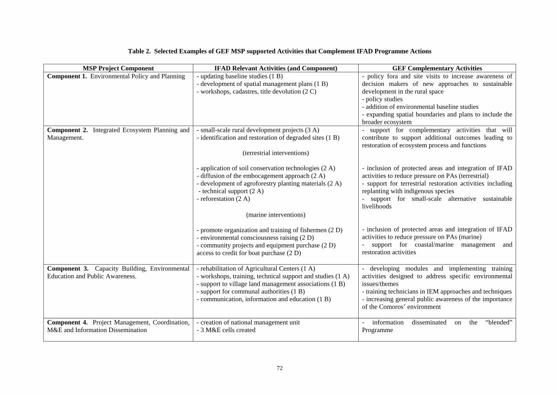
72
Table 2. Selected Examples of GEF MSP supported Activities that Complement IFAD Programme Actions
MSP Project Component IFAD Relevant Activities (and Component) GEF Complementary Activities Component 1. Environmental Policy and Planning - updating baseline studies (1 B)
- development of spatial management plans (1 B) - workshops, cadastres, title devolution (2 C)
- policy fora and site visits to increase awareness of decision makers of new approaches to sustainable development in the rural space - policy studies - addition of environmental baseline studies - expanding spatial boundaries and plans to include the broader ecosystem
Component 2. Integrated Ecosystem Planning and Management.
- small-scale rural development projects (3 A) - identification and restoration of degraded sites (1 B)
(terrestrial interventions)
- application of soil conservation technologies (2 A) - diffusion of the embocagement approach (2 A) - development of agroforestry planting materials (2 A) - technical support (2 A) - reforestation (2 A)
(marine interventions) - promote organization and training of fishermen (2 D) - environmental consciousness raising (2 D) - community projects and equipment purchase (2 D) access to credit for boat purchase (2 D)
- support for complementary activities that will contribute to support additional outcomes leading to restoration of ecosystem process and functions - inclusion of protected areas and integration of IFAD activities to reduce pressure on PAs (terrestrial) - support for terrestrial restoration activities including replanting with indigenous species - support for small-scale alternative sustainable livelihoods - inclusion of protected areas and integration of IFAD activities to reduce pressure on PAs (marine) - support for coastal/marine management and restoration activities
Component 3. Capacity Building, Environmental Education and Public Awareness.
- rehabilitation of Agricultural Centers (1 A) - workshops, training, technical support and studies (1 A) - support to village land management associations (1 B) - support for communal authorities (1 B) - communication, information and education (1 B)
- developing modules and implementing training activities designed to address specific environmental issues/themes - training technicians in IEM approaches and techniques - increasing general public awareness of the importance of the Comoros’ environment
Component 4. Project Management, Coordination, M&E and Information Dissemination
- creation of national management unit - 3 M&E cells created
- information disseminated on the “blended” Programme

73
Attachment 1. Guidelines for Preparation and Implementation of IEM sub-projects. Purpose The purpose of the sub-project investments supported under the IEM plan implementation component is to support a series of actions that address threats, underlying sources and constraints that are contributing to loss of ecosystem processes and functions in selected pilot sites. Specific interventions will be identified and prioritized through a community led process (supported under the project’s environmental planning sub-component) that will include a baseline assessment of the existing situation, identification of major threats and constraints, and an agreed on set of appropriate solutions that will contribute to the eventual restoration of the ecosystem and its associated processes and functions. Basic Principles In general, activities that would be supported under the component could be grouped into one (or more) of the following categories: (i) parks, protected areas and eco-tourism, (ii) sustainable management of agriculture, forestry and fisheries, (iii) wildlife and bio-diversity conservation, and (iv) other projects relating to the sustainable management of natural resources and development of sustainable livelihoods. Any activity falling into one or more of these groups would have to demonstrate how its impact would contribute to the improvement of the relevant ecosystem. Only village communities or groups located in the project site will be eligible for IEM investment subprojects. However, where technical expertise is required and not found in the sites, funding could be used to include external groups through agreed on partnership arrangements. Some of the funds, it well defined, could be used to support studies, capacity building and training, if it can clearly demonstrated that they are directly related to the successful preparation and implementation of a field activity. Technical assistance and equipment costs will be pre-financed out of the sub-project to support the design and follow-up to the implementation of its respective activities. No funds would be used to support involuntary physical displacement or resettlement of persons from the protected area being supported under the project. Funding for the sub-project will normally be up to a maximum of US $ 15,000. However, where necessary the Project’s management may stipulate a higher lower funding floor as applicable.
The sub-project life is specific; therefore, a beginning and end date would be stipulated. In any event, sub-project duration should normally be a maximum of two (2) years. If it becomes necessary to surpass the specified date, provision should be made for a request for an extension where justified. Application Procedures The approval of sub-project proposals would be a two-step process. The interested community group (or organization) must first submit a preliminary application form to the OIP. At minimum it would provide the following information: (i) profile of the requesting person, (ii) leading village and/or organization, (iii) project information, (iv) nature of the assistance requested and (v) letter of endorsement. Evaluators of these initial submission would be the head of the regional M&E unit, an OIP representative, and a representative from one of the technically specialized operators most competent in the material. Possible screening criteria to judge the initial application could include one or more of the following: (i) overall project feasibility, (ii) clarity and appropriateness of project goal, objectives and results, (iii) clarity in identification of issues, and how the project will address them, (iv) how it would lead to the

74
improvement of the relevant ecosystem, (v) degree of community participation in the project, (vi) level and effectiveness of partnership arrangements, (vii) significance of benefits and results at the local level, (viii) sustainability of project activities and benefits, and (ix) level of counterpart funding (including in-kind contributions). If the initial proposal is considered to be in conformity with sub-project criteria, the qualifying community or organization would then be sent a project proposal form. The full sub-project format should include at minimum the following sections: (i) goal, (ii) purpose, (iii) proposed activities, (iv) indicators, (v) constraints (assumptions and risks), (vi) qualification of the requesting organization, and (vii) project costs and proposed sources of funding.
Possible selection criteria to evaluate proposals could be drawn from Table 1.
Table 1 Possible Selection Criteria to Evaluate Proposed Sub-projects
Project Design/Definition - clarity and appropriateness of project goals, objectives and results - clarity in the identification of issues and how the project will address them - adequacy of internal management and monitoring systems - completeness and clarity of budget - overall project feasibility - adequacy of procedures for implementing the sub-project, including proposed management structures - extent of technical and cost uncertainties or risks and provisions made to guard against or account for
these risks - suitability of indicators to assessing achievement of project activities and objectives, including
arrangements for gathering data Environmental - beneficial impacts on the relevant ecosystem resulting from the sub-project - adverse environmental impacts likely to result from sub-project and relevant mitigation measures - extent of threats to biodiversity in and around the sub-project area - relevance and adequacy of environmental management plans and implementation strategies/
processes - adequacy of monitoring of mitigation measures associated with infrastructural works and sustainable
livelihood projects - environmental management capacity of project managers and capacity enhancement plans of sub-
project - availability of Environmental Assessment Report for public viewing at one or more location
Social and Economic - extent to which the different stakeholders in the sub-project have been involved in its design - the range of stakeholders who have been involved in project identification and design - consideration for the different social groups likely to be impacted by the project - socio-economic and socio-cultural impacts within and around the sub-project area - distribution of the costs and benefits between social groups - adequacy of land tenure arrangements/agreements - consideration of any indirect impact on stakeholders - level of community participation - level of stakeholder participation in the implementation of the sub-project - extent and level of partnership arrangements and partnership enhancement mechanisms - extent of integrity, openness and effectiveness of partnerships - level of collaboration of partners in capacity enhancement, public education, information sharing and
training - level of improvements in community security - responsiveness of organization’s structures and processes to community’s PA management needs - identification and consideration of product development alternatives - existence of conflict resolution mechanisms within the organization - level of inclusion of gender equity issues, particularly role of women

75
- extent to which activity will improve livelihood outcomes (income, well-being, vulnerability, food security, and sustainable use of natural resources
Institutional and Financial - financial sustainability of the sub-project and operating agency - obligations of operating agency to sustainability of sub-project outputs - structure and management capacity of the sub-project operating agency - adequacy and appropriateness of financial management and monitoring mechanisms - transparency of procurement procedures - reliability and strength of internal control mechanisms - technical and managerial capacity of the project management team - adequacy of mechanisms to ensuring effective partnership arrangements
Alternative Livelihoods - suitability of land tenure arrangements - existence of co-management agreements within PA - impact of project on other livelihoods (especially traditional livelihoods) - history of group/community collaboration in PA - level of existing resources for the PA - potential for alternative livelihood opportunities in and around the PA - identification of proposed investments or production opportunities and possible implementation
strategies - effectiveness of information dissemination strategies
Sub-project proposals will be approved by the same members of the pre-screening group. Ultimate decision lies with the Project Coordinator. Sub-project Monitoring
Once a sub-project has been approved the process of implementation will begin. It will be the task of local M&E cell to monitor the operational aspects of the sub-project. Each sub-project proposal will include an implementation plan scheduling the activities, the person/institution responsible for each activity, targets to be achieved, and the timeframe for implementation. Assessment of targets and impacts will be influenced by the agreed on checklist for evaluating project proposals. While the assessments cannot be as detailed as in the checklist they will as much as possible, give due regard to the key indicator groups contained in the checklist. The results of sub-project monitoring will be incorporated in the overall Project’s M&E system (see Appendix 6).
Next Steps As noted above, specific interventions supported under this sub-component will be identified and prioritized through a community led process supported under the project’s environmental planning sub-component leading to the development of up to six ecosystem management plans. It is presently projected that two of these plans would be completed during 2008 followed by the remaining four in 2009. In parallel to the preparation of the initial two plans, a consultant will be contracted to prepare a manual to guide the implementation of the IEM Plan Implementation sub-component. Through this approach, sub-project preparation, review and implementation procedures would be fully detailed and ready to be applied at the time of plan finalization. The manual would describe the procedure for soliciting, designing, screening, and reviewing sub-project proposals. The consultant would also be responsible for preparing: (i) guidelines for proposal writing, (ii) a checklist for evaluation project proposals, (iii) preparing the associated formats needed for technical and financial reporting, (iv) developing contract templates, and (v) proposing a practical monitoring and evaluation system. The consultant would also describe the most cost-efficient means to integrate these procedures and processes in the project management structure for the blended Programme. Finally, the consultant should recommend an evaluation system to assess the results of the activity at the end of the sub-project cycle.

76
Attachment 2. Illustrative Sub-project Profile: Sustainable Management of Emergent Reefs and Mangrove Protection20
Goal and Rationale: Bimbini (Anjouan) is blessed with a rich endowment of coastal and near shore marine resources dominated by and beaches, mangroves, marine grass beds and coral reefs. The numerous white sand beaches in addition to supporting recreational use both by local and visitors are famous for being nesting sites to two of the four marine turtles found in Comoros waters. The mangroves that enclose a partial lagoon in front of the village of Bimbini provide protection from offshore storms, critical habitat to commercial important fish (and other species), and a source of nutrients to the surrounding waters. Further offshore are marine grass beds and an extensive fringing coral reef that further protect the village from offshore storms as well as providing habitat and food to a broad range of marine life. Despite the abundance and significance of these habitats they are rapidly becoming degraded. Major threats include: (i) illegal harvesting for fuel wood and suffocation due to solid wastes (mangroves), (ii) die-off due to the sedimentation (coral reefs and marine grass beds) and trampling associated with gleaning of emergent reefs (coral reefs); and (iii) despoliation due solid waste and sand mining (beaches). Purpose: The project purpose is to protect and where possible restore, critical coastal habitat in Bimbini’s coastal area.
Activities: The following actions are proposed: (i) establish and sensitize a local village group to implement the proposed activity; (ii) develop a village coastal area management plan that would include the aforementioned habitats (to include identification of nature and source of natural habitat degradation, a proposed zoning scheme, and priority actions and institutional mechanisms to implement it); (iii) establish an environmental baseline to ascertain the present status of the habitats; (iv) establish an inter-village council to facilitate the identification of remedies to address upstream sources of sediment; (v) implement a riparian tree planting programme to reduce sediment loads in coastal areas; (vi) “clear” the existing stands of mangroves of the plastic sacks (and other solid waste) that have washed up and covered the root systems serving to suffocate intolerant species; (vii) replant mangroves where they have been destroyed through non-sustainable harvesting practices and replace older species at risk of dying with seedlings; (viii) work with local “gleaners” to develop a micro-zoning plan and “best practices” designed to reduce pressure on the emergent reef; (ix) prevent the further illegal exploitation of mangroves and other critical habitat through a public environmental awareness programme; (x) identify one or more suitable alternative livelihood activities designed to absorb reductions in income/food due to the phasing in of sustainable harvesting levels in mangroves and emergent reefs; (xi) develop and implement “clean village” days dedicated to the cleaning of the village beaches’ of solid waste; (xii) create and sensitize district management groups to sort out household wastes; (xiii) identify an area and transform it into an environmentally suitable site for the deposition and incineration of local wastes; and (xiv) provide a guard to dissuade the individuals responsible for violating previously agreed to measures designed to protect and conserve the village’s mangroves and coral reefs. Indicative output indicators: (i) area of mangrove planted (ha), (ii) survivability of planted mangrove (%), riparian trees planted along water courses (km), and (iv) individuals cited for illegal harvesting of mangroves (#). Indicative outcome indicators: (i) increase in biodiversity richness index in emergent reefs, (ii) reductions in sedimentation loads reaching coastal waters, and (iii) changes in human behavior in their use of village coastal resources. Constraints: (i) villages will collaborate with each other, (ii) sufficient village capacity can be created to undertake the sub-project, (iii) no major natural hazards will occur during the project 20 Partially based on project proposal submitted by Ms. Fatima Maanfou (President of Offensive Pour l’Action Sociale (OPAS) of Bimbini.

77
implementation period, (iv) sufficient alternative sources of income can be generated to support reduction on the resource base to sustainable levels. Qualification of requesting organization: Offensive Pour l’Action Sociale (OPAS). An association composed of 100 % women based in Bimbini.

78
Attachment 3 a. Site Profile # 1: Lac Dziani Boundouni (Mohéli) Predominate Ecosystem: Freshwater lake. Description and Location: Lac Dziani Boundouni is a freshwater crater lake that measures approximately 30 ha in area. It is located in the south-east part of Mohéli in the Djando region and bounded to the West by Hamavouna village, to the north by the Massif and the Boundouni Cone, and to the east by Itsamia Village. Biodiversity Significance: The primary reason for its designation as a RAMSAR site is provision of habitat for a diverse range of waterfowl, many of which are international migratory species and include the Little Grebe (Tachybaptus ruficollis) the most predominate species (estimated to represent more than 1 % of the biogeographical population of the species). Other species include Malagasay Pond Heron (Ardeola idea), Greenshank (Tringa nebularia) and the Common Sandpiper (Actitis hypoleucos) The lake is also significant in terms of its limnological characteristics including local vulcanism that has contributed to varying changes in water levels and distinct submerged physical structures. These have been cited as the sources of a number of local beliefs created to explain these features and processes. Threats: Despite the relative difficulty in accessing the lake, there is widespread cattle grazing in its lacustrine areas including the use of fencing to control the cattle. Where there still exist remnant forests surrounding the lake (largely confined to the steep slopes of the crater) forest fires represent a threat. In the land bordering the lake where a more gradual slope exists, past deforestation has changed much of the remaining vegetation and affected the ecology of the lake’s drainage area and processes. Loss of vegetative cover and accelerated erosion represent a major source of sedimentation in the lake and over time has contributed to increased water turbidity and in-filling. Previous Conservation Efforts: A management plan was prepared through a grant (US $ 20,000) from RAMSAR Small Grant Fund in 1997. Other: It was designated a RAMSAR site in 1 January 1997. Relevance to IFAD Project Site: Côte côtière. The IFAD site has been characterized as having a high incidence of poverty and widespread deforestation and erosion. This is at least partially offset by the presence of a strong community organization and large potential for growth in agricultural production and exportation of food crops; both strategies that could be used to reduce pressure from extensive grazing on riparian zones of the lake. Possible Interventions: (i) establishing an environmental baseline of lake, (ii) developing a management plan, (iii) removing (or mitigating) sources of sedimentation affecting the lake, (iv) phasing out of cattle grazing the internal drainage area of the Lake, (v) replacement of tobacco with other less harmful crops to soils, and (vi) provision of minimum infrastructure, personnel, and equipment to support tourist visitation and building on the adjacent tourist destination zones of Itsamia village (turtle nesting sites) and the Mohéli Marine Park.

79
Attachment 3 b. Site Profile # 2: Bimbini – Ile de la Selle Zone (Anjouan) Predominate Ecosystems: Mangroves, coral reefs, marine grass beds, and sand beaches. Description and Location: Located on the south-west coast of Anjouan, the peninsula of Bimbini is characterized by a rich diversity of coastal/near-shore habitats. The mangrove systems and coastal wetlands exist in a fragmented band extending over 7 km of coastline (a total of 8 ha in area) which partially serves to enclose a coastal lagoon. The main mangroves species are Sonneratia alba, Avicennia marina, and Rhizophora mucronata. Marine grass beds are extensive and serve as a critical food source for a number of marine vertebrates (including several species of marine turtles) and invertebrates. Coral reefs are mostly fringing reefs and represent nearly 100 % cover in front of the project site. Grouped by morphological type, coral species are dominated by Favia and Favites (massive), Acropora (branching) Turbinaria and Montipora (foliated) and Platygyra and Leptoria (meandering). Biodiversity significance: In addition to the high biodiversity associated with mangrove, marine grass beds and coral reefs, the adjacent sandy beaches are also of significance. Of the four marine turtle species21 that occur in the Comoros waters, sandy beaches are used by two of them (the green and leatherback) to lay their eggs including at the pilot site. Both are threatened species. In addition to a wide range of marine vertebrates and invertebrates, marine grass beds also provide food for the threatened dugong (Dugong dugon). Threats: Major anthropomorphic threats include: (i) removal and loss of vegetative cover in upstream areas contributing to accelerated downstream sedimentation affecting mangroves, reefs, and grass beds; (ii) localized pollution; (iii) over-exploitation of coastal and near shore marine resources (e.g., direct extraction of corals and sand for use as construction aggregate, illegal harvesting of mangrove for fuel wood) and its effects on local ecosystem dynamics; (iv) trampling on emergent corals associated with the gleaning of corals to harvest edible invertebrates and shells for shell craft; (v) non-sustainable fishing practices adversely impacting critical habitat (use of small mesh nets, dynamite); and (vi) solid waste contributing to the suffocation of mangroves. Previous Conservation Efforts: Proposed as a marine protected area. Other: The area, like much of the Comoros, is also exposed to natural threats that include periodic increases in sea temperature (affecting corals), proliferation of certain species upsetting the ecological balance (e.g., Acanthaster), and extreme events (e.g. cyclones and low tides). Relevance to IFAD Project Sites: Presqu’île de Bimbini. The IFAD site has been characterized as having a high incidence of poverty and growing dependence on fishing due to land scarcity resulting in increased pressure and on the resource and use of non-sustainable fishing practices. Support for increased agricultural production and incentives to fish further off-shore could reduce pressure on the coastal ecosystems. Possible Interventions: (i) zoning, (ii) development of management plan (s), (iii) reforestation of mangrove areas, (iv) sustainable management strategy for mangrove harvesting, (v) solid waste treatment, and (vi) introduction of conservation practices for marine turtles.
21 These are the green (Chelonia mydas), hawksbill (Eretmochelys imbricata), loggerhead (Caretta caretta) and leatherback (Dermochelys coriacea) turtles.

81
Attachment 3 c. Site Profile # 3: Forêt La Grille (Grande Comore) Predominate Ecosystems: Forest Ecosystem Description and Location: This is one of the two remaining forests found in Grand Comoros (the other being Karthala). It is humid forest found growing at an average elevation of 1000 m. The forest is located on the La Grille “peninsula” which reaches 1,087 m at its highest elevation and is separated from the much larger volcano Karthala by the plateau of Dibwani, the latter which has an average elevation ranging between 500 and 600 m. The upper strata of the forest is composed of the few large trees remaining from the original natural forest (15 m high or higher). These are represented by such species as Chrysophyllum, Tambourissa, Macaranga, Ceiba, Anthocleista, and Ficus. The intermediate strata of the canopy is dominated by trees 3 to 4 meters in height and is largely composed of a successor stage of recruitment forest while the lowest strata is covered by dense vegetation dominated by bush and grass. Biodiversity significance: Forêt La Grille represents one of two remaining forests found in Grand Comoros with some remaining old growth forest. Threats: All mature forest habitat on the Comoros islands is highly threatened by agricultural expansion. Forêt La Grille is characterized by a high degree of human intervention. The forest is estimated to be 95 % invaded by local villagers practicing an agro-sylvo-pastoral system dominated by bananas (between 600 and 1200 m), tarot and some cash crops in the flatter portions of the forest. The present approach to harvesting bananas is particularly destructive to the native forest. Expansive grazing of cattle is also pervasive. There has also been extensive reforestation in the past using exotic species (e.g., Eucalyptus and Casuarina). Previous Conservation Efforts: - NA - Other: - NA - Relevance to IFAD Project Sites: Le Hamahamet is characterized by the presence and process of massive deforestation despite the availability of abundant land to support long term agricultural production. Insecurity of tenure has been cited as the main constraint preventing farmers from maximizing the productive potential of these adjacent lands. Land in proximity to the forest site in the adjacent plateau could be used to support an intensive and sustainable agriculture practices which will be the direction supported by the IFAD baseline project. Possible Interventions: (i) zoning of the forest, (ii) clarifying tenure situation that affects the forest, (iii) phasing out destructive practices in the forest, (iv) replanting and restoration of native forests, (v) gradual phasing out of exotic species of forest species and replaced with local species, (vi) replacing existing destructive agro-sylvo-pastoral production practices with more sustainable forms.

82
Appendix 6: Monitoring and Evaluation Plan
Comoros: Integrated Ecological Planning and Management in Coastal Ecosystems
The proposed GEF MSP is a "blended" project and the task of its monitoring and evaluation (M&E) will be fully incorporated into the M&E programme associated with IFAD’s National Sustainable Development Programme. The monitoring of the MSP will be established on the basis of the Project’s logical framework which subsequent to approval will be integrated into the Programme’s framework to ensure monitoring consistency between baseline interventions and GEF incremental activities. Monitoring of both the project performance and impact will be conducted in accordance with the indicators and the means of verification set in the consolidated logical framework. Much of the description below describes the Programme’s M&E structure, system and processes and reporting. Where relevant, GEF M&E requirements have been explicitly noted. The tasks associated with the Programme’s M&E include: (i) the centralization, organization, consolidation and analysis of internal reports submitted from the contractors, the regional M&E units (URSE) and the national coordinating unit (UCP); (ii) the development and monitoring of programme activities; (iii) elaboration of periodic reports as required by the loan, GEF and other co-financiers; (iv) organization and supervision of baseline studies and thematic surveys to evaluate the Programme impact on the beneficiaries; and (v) methodological support to the three regional M&E cells and communities to faciliate data collection. Institutional Structure and Responsibilities for M&E The Programmes’management structure will consist of the following: (i) a national coordinating unit (UCP) at the level of the Union composed of : (a) a national coordinator, (b) budget officer, (c) M& E specialist, and (d) support personnel; (ii) M&E cells established in each of the 3 island’s ministries responsible for agriculture, (iii) a comité national de pilotage (CNP) that will be composed of the major stakeholders, and (iv) a comité régional de coordination du programme (CRCP). In addition, there will be participating government line agencies at both the Union and regional levels, contractors, and participating communities; stakeholders all. For more detail on the Programme’s management aspects see Appendix 5. The UCP’s M&E specialist will have overall responsibility for the Programme’s M&E activities under the direct supervision of the national coordinator. At the level of the regions (islands), small two person cells (URSE) consisting of one full-time professional and secretary will be integrated in the director general’s office of the ministry responsible for production. These regional cells will have the task of directly supervising the execution of the Programme’s field activities in conformity with that year’s approved PTBA (see below). Each URSE will have administrative and management automony faciliated through control over their respective budget as approved in the current year’s PTBA . The UCP M&E specialist, in close collaboration with the national programme coordinator, will be responsible for preparing: (i) monthly notes, (ii) a quarterly progress report (see below) supported with the necessary recommendations and documentation that will permit the national coordinator to take any decision necessary to ensure that the Programme is meeting its agreed on objectives; and (iii) an annual M&E report in support to the preparation of the Programme’s annual activty reports for the past year. Despite these formal responsibilities it must also be pointed out that internal supervsion of the Programme activities will be established on a permanent basis throughout the life of the Programme (LOP). While it is recognized that overall responsibility for the Programmes’s supevision rests with the national project coordinating unit (UCP), monitoring responsibities have also been incorporated into Programme design that will involve the beneficiaries directly in this task (e.g, village

83
communities, contractors, participating unions and federations, financial institutions). Their participation in supervision will be insured through contractual obligations specifiying their role, reporting format and periodicity of report submission. System and Sources of Information to support M & E The Programme’s system of M&E will consist of: (i) permanent internal monitoring, (ii) periodic internal and external evaluations, (iii) participative analyses and impact studies and research, and (iv) the preparation of the local development plan (PDL) and annual work plan (PAT) with direct participation by the communities. The main sources information that will “feed” the M&E system are: (i) the M&E participative beneficiary workshops, (ii) baseline studies, (iii) PDLs and PATs elaborated directly with the communities, (iv) documents associated with approved sub-projects, (v) the URSE and UCP reports, (vi) the reports from contracted operators, (vii) impact studies and evaluations contracted to independent institution, (viii) financial monitoring and internal management control by UCP and (viii) supervison mission reports. Annual Work Plan and Budget (PTBA) The day to day monitoring of MSP implementation will be driven by the preparation and implementation of the Programme’s annual work plan and budget (PTBA). The preparation of the PTBA represents the product of a unified planning process beginning at the community level. As a tool, it will identify the actions proposed for the coming project year and provide the necessary detail to monitor their implementation. Regional PTBAs will be prepared by the island’s respective M&E units (URSE) in consultation with representatives from the participating communities facilitated through a series of annual participative planning workshops. The draft regional PTBAs will be reviewed by the Programme’s Regional Committee for Programme Coordination (CRCP) before forwarding them to the Programme Coordinating Unit (UCP). Once received and reviewed by the Coordinator, the 3 regional PTBAs will be consolidated and forwarded to IFAD and the Programme’s other co-financiers including GEF. The annual work plan will be developed in a manner consistent with the project’s logframe to ensure adequate fulfillment and monitoring of project outcomes. Following MSP approval, the first (and subsequent) year work plan and budget will follow the preparation calendar for the Programme’s PTBA. Reports and Reporting Project Implementation Report (PIR). The GEF PIR is an annual review process mandated by the GEF. Projects under implementation for a year by the end of June of that year must submit a PIR Report. PIR reports are completed by the executing agency in close collaboration with the project team. A GEF M&E PIR template will be shared with the UCP which will be completed according to the project M&E plan. Quarterly Progress Reports. QPRs will outline main information and data on programme progress and performance. They should be provided quarterly by the UCP. Programme Terminal Report (PTR). The Programme Terminal Report will be prepared during the last three months of implementation by the UCP. The PTR is a comprehensive overview summarizing all programme activities, outputs and results, impact, lessons learned, objectives met or not achieved etc. The PTR is the definitive statement of programme’s activities but it should include recommendations for any additional measures that could be taken to ensure sustainability and replicability/up scaling of the project outcomes.
84
Technical reports. The UCP will be required to define from the onset a draft plan and list of expected technical reports on relevant areas of intervention to be developed during programme life. If necessary, technical reports may also be prepared by external consultants and should focus on the specific area of intervention (geographical and//or thematic). The technical report should outline the Programme’s contribution to specific areas and can be used as effective dissemination tools of best practices or innovations. Optional publications that can be based on technical reports will need to be defined by the UCP and adequate resources should be allocated as appropriate from the programme funds. Independent Evaluations. The Programme will be subject to independent mid-term and final evaluations. The independent mid-term evaluation will be undertaken in 2009 with the participation of all financial partners. Mid-term evaluation determines progress made towards the achievement of Programme outcomes and should recommend adjustments if any. Mid-term evaluations focus on project effectiveness and implementation efficiency. This evaluation will also outline initial lessons learnt and its findings should be primarily considered for an improved implementation of the Programme. The review will specifically include the evolution of the Programme and the harmonization of the GEF activities into the former. The TORs for the mid-term evaluation will be prepared in consultation between all parties. The final evaluation will take place three months prior to the terminal bipartite review meeting with a similar scope to the mid-term evaluation. However, the final evaluation should focus, in particular, on Programme impact (local and global), results and sustainability. The final evaluation will provide recommendations for follow-up and replication of best practices. The ToRs for this evaluation will be prepared in consultation with IFAD and all key stakeholders. M&E Manual An M&E Manual which will be prepared by the UCP within two months of the loan becoming effective. Specific monitoring approach and indicators will be developed and included in this manual which will include indicators identified to faciliate the monitoring and reporting of programme progress contributing to GEF Strategic Objectives (SOs). With respect to the biodiversity activities, the UCP will submit the information required for the GEF biodiversity tracking tools. At the field-level, M&E responsibilities will be the task of the communities themselves as the key participant in the Programme. They will be assisted by each of the island's URSE. Programme Start-up Activities During Programme start-up, the UCP will develop criteria for participatory monitoring of programme activities in consultation with key stakeholders subsequent to which appropriate participatory mechanisms and methodology for performance monitoring and evaluation will be established. The UCP will mobilize specialized consultants to faciliate putting into place the M&E system as described above. During the first IFAD supervison mission, M&E related tasks will include: (i) finalizing the logical framework with the other Programme stakeholders; (ii) review the M&E indicators; (iii) identify the required baseline information needed to support the M&E programme; iv draft the required clauses to include in consultants’ contracts to ensure they complete their M&E reporting fucntions; and (v) clarify the respective M&E tasks among the Programme’s different stakeholders. Monitoring indicators will be finalized during the start-up period. Role of IFAD IFAD will be responsible for the direct supervision of the Programme. It will be the responsibility of IFAD’s Country Portfolio Manager to determine the number and timing of supervision missions necessary to ensure the satisfactory implementation of the Programme. These missons will additionally include representatives of the government and co-financiers. Moreover, the Programme will be closely monitored by IFAD through quarterly meetings/teleconferences or more frequently as

85
deemed necessary. The UCP will inform IFAD of any delays or difficulties faced during implementation to ensure smooth implementation. Technical modalities of Project Monitoring Technical monitoring will consist of the establishment of environmental baselines and annual monitoring in: (i) up to 6 MSP supported “ecosystems” once these have been defined and agreed to by the local communities, and (ii) the 3 candidate protected areas that are proposed for inclusion in the Project. Under the MSP’s planning sub-component, environmental baseline studies are budgeted for supplemented with national and international technical assistance. As part of the studies, appropriate monitoring indicators will be identified to ascertain environmental status of the ecosystems during and subsequent to project interventions. It is likely that these will be surrogate indicators (e.g., bio-indicators) to ensure that these can be monitored by the villagers themselves. Moreover, given the vagaries of the environment (e.g., rainfall) relative to the very short project life, it should not be expected that conclusive evidence of increased “health” of the ecosystem will be forthcoming. Under the Protected Area sub-component, the WWF-WB scorecards for protected areas will be used to monitor the effectiveness of PA management. These will be modified to make them appropriate to the situation in Comoros and be prepared initially as part of the management plan process. They will subsequently be filled in on an annual basis. These will be the primary tool for capturing the necessary data to address GEF Biodiversity SO # 1.
Table 1. Monitoring and Evaluation Work Plan
M&E Activity Responsible Parties Timeline Annual monitoring of project progress and performance
UCP and URSE Annually for first 3 years only
Capacity building and training in M&E activities
National institutions supplemented by national and international TA
will occur in first six months of PY 1 and repeated in PY 2 as remaining sites come on board.
PIRs UCP and IFAD Annually Establishment of environmental baseline and monitoring of MSP-supported ecosystems
National institutions Baseline established in PY 1, annual monitoring from PY 2 – PY 4, thereafter.
Technical monitoring of MSP-supported PAs using scorecards
National institutions supplemented by national and international TA
Baseline established in PY 1, annual monitoring from PY 2 – PY 4, thereafter.
Technical Reports Programme team External consultants if needed
Cost incorporated in studies activities and int. TA
Quarterly progress reports UCP and URSE coordinator
Every 3 months after project start up
Terminal report Programme team
At least one month before the end of the project
Mid-term external evaluation External consultants (oversight by IFAD)
Mid-term of project implementation (after 2 years)
Final external evaluation External consultants (oversight by IFAD)
At the end of project implementation (three months prior to the terminal tripartite review meeting)
Audit Recognized auditor (oversight by IFAD)
Yearly

86
Appendix 7: Terms of Reference
7.1 National Coordinator
The national coordinator will be based in Monori he will be responsible for the overall management of the GEF component. He/She will ensure timely planning and implementation of project activities and will be specifically responsible for:
1. Ensure overall daily management of the project; 2. Prepare technical and progress reports
3. Prepare workplans and budgets
4. Coordinate the preparation of the GEF PTBAs and ensure that they are well aligned with the
NSHDP
5. Supervise and co-ordinate project activities, in line with project outputs and outcomes, and in close collaboration with all stakeholders.
6. Ensure the technical and financial coordination of the project activities between the three
islands
7. Draft TORs for the consultants and sub-contractors;
8. Supervise and coordinate the work of project consultants and sub-contractors;
9. Oversee the exchange and sharing of experiences and lessons learned with relevant conservation and development projects nationally and internationally.
10. Undertaking any other GEF-related activities that may be assigned by the NSHDP
11. Monitor the follow up of evaluation recommendations
12. Facilitate, act as resource person, and join if required any external missions.
7.2 The M&E Specialist
The project M&E specialist will be responsible for Responsible for the overall implementation of Monitoring and Evaluation functions according to the M&E work plan and project Document. He/She will specifically:
1. Coordinate the preparation of all progress reports. This includes quarterly progress reports, annual project report, and ad-hoc technical reports as required.

87
2. Prepare consolidated progress reports for project management including identification of problems, causes of potential bottlenecks in project implementation, and providing specific recommendations.
3. Check that monitoring data is accurate regularly collected in a timely manner. 4. Undertake regular visits to the field to support implementation of M&E and to identify where
adjustments might be needed.
5. Prepare draft TORs for mid-term and final evaluation in accordance to IFAD and GEF
guidance. 6. Maintain continuous communication with the NSHDP team to ensure a harmonized and
consolidated monitoring of the overall project impact

GEF-4 Tracking Tool for GEF Biodiversity Focal Area Strategic Objective Two: Mainstreaming Biodiversity Conservation in Production Landscapes/Seascapes and Sectors
1
I. Project General Information
1. Project Name: Integrated Ecological Planning and Sustainable Land Management in Coastal Ecosystems in the Comoros
2. Project Type (MSP or FSP): MSP 3. Project ID (GEF): 3363 4. Project ID (IA): To be assigned 5. Implementing Agency: IFAD 6. Country(ies): Comoros
Name of reviewers completing tracking tool and completion dates:
7. Project duration: Planned_4______ years Actual ____4___ years 8. Lead Project Executing Agency (ies): Ministry of Agriculture, Fisheries and Environment 9. GEF Strategic Program:
x Strengthening the policy and regulatory framework for mainstreaming biodiversity (SP 4)
Fostering markets for biodiversity goods and services (SP 5)
10. Production sectors and/or ecosystem services directly targeted by project: 10. a. Please identify the main production sectors involved in the project. Please put “P” for sectors that are primarily and directly targeted by the project, and “S” for those that are secondary or incidentally affected by the project. Agriculture_P_______ Fisheries__S________ Forestry__S________ Tourism___________ Mining_______ Oil__________ Transportation_________ Other (please specify)___________
Name Title Agency Work Program Inclusion
Project Mid-term
Final Evaluation/project completion

GEF-4 Tracking Tool for GEF Biodiversity Focal Area Strategic Objective Two: Mainstreaming Biodiversity Conservation in Production Landscapes/Seascapes and Sectors
2
II. Project Landscape/Seascape Coverage 11. a. What is the extent (in hectares) of the landscape or seascape where the project will directly or indirectly contribute to biodiversity conservation or sustainable use of its components? An example is provided in the table below.
Targets and Timeframe Project Coverage
Foreseen at project start
Achievement at Mid-term Evaluation of Project
Achievement at Final Evaluation of Project
Landscape/seascape1 area directly2 covered by the project (ha)
1,660 ha
Landscape/seascape area indirectly3 covered by the project (ha)
2,138 ha
Explanation for indirect coverage numbers: Core Core in vestment on 1660 ha of land put under SLM by the end of the project. Secondary impact will be generated in surrounding coastal ecosystems. Capacity building for 390 groups and fisherman and development of at least 6 IEM plans will lead to off-site positive impacts on both land and biodiversity conservation. Estimate overall landscape/seascape targeted by secondary impact is about 2,138 ha by the end of the project 11. b. Are there Protected Areas within the landscape/seascape covered by the project? If so, names these PAs, their IUCN or national PA category, and their extent in hectares.
Name of Protected Areas IUCN and/or
national category of PA
Extent in hectares of PA
1. Lake Dziani Boudouni Ramsar Site 30 ha 2. Brimini-Ile de la selle
Zone TBD 8 ha
3. Forêt La Grille TBD 440 ha 11. c. Within the landscape/seascape covered by the project, is the project implementing payment for environmental service schemes? If so, please complete the table below. An example is provided. NA
1 For projects working in seascapes (large marine ecosystems, fisheries etc.) please provide coverage figures and include explanatory text as necessary if reporting in hectares is not applicable or feasible. 2 Direct coverage refers to the area that is targeted by the project’s site intervention. For example, a project may be mainstreaming biodiversity into floodplain management in a pilot area of 1,000 hectares that is part of a much larger floodplain of 10,000 hectares. 3 Using the example in footnote 5 above, the same project may, for example, “indirectly” cover or influence the remaining 9,000 hectares of the floodplain through promoting learning exchanges and training at the project site as part of an awareness raising and capacity building strategy for the rest of the floodplain. Please explain the basis for extrapolation of indirect coverage when completing this part of the table.

GEF-4 Tracking Tool for GEF Biodiversity Focal Area Strategic Objective Two: Mainstreaming Biodiversity Conservation in Production Landscapes/Seascapes and Sectors
3
III. Management Practices Applied
12.a. Within the scope and objectives of the project, please identify in the table below the management practices employed by project beneficiaries that integrate biodiversity considerations and the area of coverage of these management practices. Please also note if a certification system is being applied and identify the certification system being used. Note: this could range from farmers applying organic agricultural practices, forest management agencies managing forests per Forest Stewardship Council (FSC) guidelines or other forest certification schemes, artisanal fisherfolk practicing sustainable fisheries management, or industries satisfying other similar agreed international standards, etc. An example is provided in the table below. Specific management practices that integrate BD
Name of certification system being used (insert NA if no certification system is being applied)
Area of coverage foreseen at start of project
Achievement at Mid-term Evaluation of Project
Achievement at Final Evaluation of Project
1. SLM NA 1,660 ha 2. management Plan and conservation of the mangrove system in Bimbini – Ile de la Selle Zone (Anjouan)
NA 8 ha
3 Environmental baseline and management plan for Lac Dziani Boundouni
NA 30 ha
4. Zoning of the Forêt La Grille and mainstreaming SLM
NA 440 ha
IV. Market Transformation 13. For those projects that have identified market transformation as a project objective, NA Only a policy study on how to increase value of selected environmental goods and services will be carried out

GEF-4 Tracking Tool for GEF Biodiversity Focal Area Strategic Objective Two: Mainstreaming Biodiversity Conservation in Production Landscapes/Seascapes and Sectors
4
V. Policy and Regulatory frameworks For those projects that have identified addressing policy, legislation, regulations, and their implementation as project objectives, please complete the following series of questions: 14a, 14b, 14c. An example for a project that focused on the agriculture sector is provided in 14 a, b, and c. 14. a. Please complete this table at CEO endorsement for each sector that is a primary or a secondary focus of the project. Please answer YES or NO to each statement under the sectors that are a focus of the project.
Sector Statement: Please answer YES or NO for each sector that is a focus of the project.
Agriculture Fisheries Forestry Tourism Other (please specify)
Other (please specify)
Biodiversity considerations are mentioned in sector policy YES Yes (partially)
Yes (partially)
Biodiversity considerations are mentioned in sector policy through specific legislation
Yes No No
Regulations are in place to implement the legislation NO No No The regulations are under implementation NO No No The implementation of regulations is enforced NO No No Enforcement of regulations is monitored NO No No

GEF-4 Tracking Tool for GEF Biodiversity Focal Area Strategic Objective Two: Mainstreaming Biodiversity Conservation in Production Landscapes/Seascapes and Sectors
5
14. b . Please complete this table at the project mid-term for each sector that is a primary or a secondary focus of the project. Please answer YES or NO to each statement under the sectors that are a focus of the project. Sector Statement: Please answer YES or NO for each sector that is a focus of the project.
Agriculture Fisheries Forestry Tourism Other (please specify)
Other (please specify)
Biodiversity considerations are mentioned in sector policy YES Biodiversity considerations are mentioned in sector policy through specific legislation
YES
Regulations are in place to implement the legislation NO The regulations are under implementation NO The implementation of regulations is enforced NO Enforcement of regulations is monitored NO
14. c. Please complete this table at project closure for each sector that is a primary or a secondary focus of the project. Please answer YES or NO to each statement under the sectors that are a focus of the project. Sector Statement: Please answer YES or NO for each sector that is a focus of the project.
Agriculture Fisheries Forestry Tourism Other (please specify)
Other (please specify)
Biodiversity considerations are mentioned in sector policy YES Biodiversity considerations are mentioned in sector policy through specific legislation
YES
Regulations are in place to implement the legislation YES The regulations are under implementation YES The implementation of regulations is enforced NO Enforcement of regulations is monitored NO

GEF-4 Tracking Tool for GEF Biodiversity Focal Area Strategic Objective Two: Mainstreaming Biodiversity Conservation in Production Landscapes/Seascapes and Sectors
6
All projects please complete this question at the project mid-term evaluation and at the final evaluation, if relevant: 14. d. Within the scope and objectives of the project, has the private sector undertaken voluntary measures to incorporate biodiversity considerations in production? If yes, please provide brief explanation and specifically mention the sectors involved. An example of this could be a mining company minimizing the impacts on biodiversity by using low-impact exploration techniques and by developing plans for restoration of biodiversity after exploration as part of the site management plan. ______________________________________________________________________________________________________________________________________________________________________________________________________________________________________________________________________________________________________________________________________________________ VI. Other Impacts 16. Please briefly summarize other impacts that the project has had on mainstreaming biodiversity that have not been recorded above. ______________________________________________________________________________________________________________________________________________________________________________________________________________________________________________________________________________________________________________________________________________________________________________________