Embed Size (px)
Citation preview
1200 East 151st Street, Olathe, KS 66062 p: 866.739.5687 f: 913.397.8282
GARMIN (EUROPE) LTD. Liberty House, Hounsdown Business Park Southampton, Hampshire, SO40 9LR, U.K. p: +44 (0)87.0850.1243 f: +44 (0)23.8052.4004
GARMIN SINGAPORE PTE. LTD. 46 East Coast Road #05-06, Singapore 428766 p: 65.63480378 f: 65.63480278e: [email protected]
MOVING THE INDUSTRY FORWARD
INTEGRATED FLIGHT DECK SOLUTIONS
Garmin.com
©2017 Garmin Ltd. or its subsidiaries. All rights reserved.Specifications and descriptions are preliminary and subject to change without notice.The Bluetooth word mark and logos are registered trademarks owned by Bluetooth SIG, Inc. and any use of such marks by Garmin is under license.iPad, iPhone and Apple are trademarks of Apple Inc., registered in the U.S. and other countries.Android™ is a trademark of Google Inc®
GARMIN INTERNATIONAL, INC.
MXX-XX-XXXX
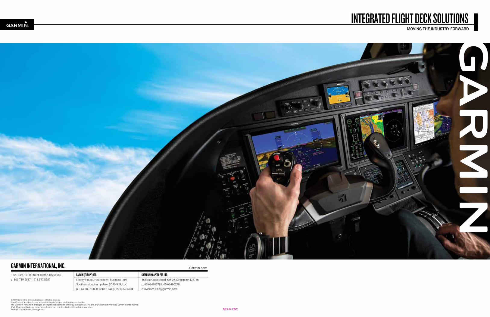
Whether you fly a large business jet, a hard-working helicopter, a light jet, a turboprop, piston twin or single-engine aircraft – whatever size or shape your cockpit takes, you can be sure there’s a Garmin glass flight deck solution perfectly scaled to fit. No other leading avionics manufacturer offers such breadth of capability – or such versatile configurability – in its lineup of glass-integrated suites for new aircraft and aftermarket installation. Designed to help pilots make better decisions faster, each of these Garmin glass systems seamlessly integrates control and presentation of virtually all “big picture” flight references used in the cockpit. Information once scattered across myriad instruments and gauges is now consolidated for easy viewing on a pilot’s primary flight display (PFD) and multifunction display (MFD).
GARMIN INTEGRATED FLIGHT SYSTEMS: SOLUTIONS SCALED FOR ANY SIZE AIRCRAFT
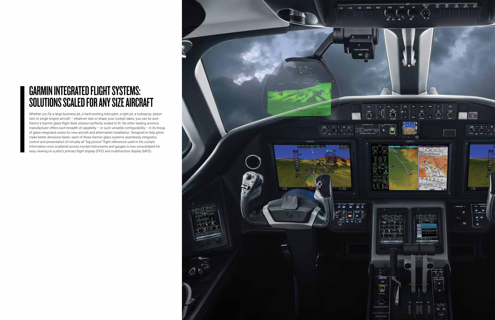
By presenting key aircraft performance, navigation, weather, terrain and traffic information, in context, on large high-resolution color displays, today’s Garmin glass systems bring a whole new level of clarity and simplicity to flight. The screens offer wide viewing angles, advanced backlighting and crystal-sharp readability, even in bright sunlight. A graphical 3-axis flight display on the PFD synthesizes aircraft attitude, airspeed, climb rate, altimeter and horizontal course/heading information – as well as Flight Director command bar cues and mode information, when coupled with a Garmin digital automatic flight control system (AFCS). The Garmin AFCS also supports such capabilities as coupled LPV approaches, vertical navigation, coupled go-arounds, electronic stability and protection (ESP), flight level change (FLC) and other sophisticated autopilot features.
More and better information.
Proven AHRS attitude/heading reference delivers high-precision spatial sensing for the system’s digital instrumentation, replacing old-style gyros. And for added situational awareness, Garmin SVT™ synthetic vision is available to provide a realistic 3-D “virtual reality” view of terrain, traffic, airports, pathways and obstacles on the pilot’s flight display. Alongside, a multitasking MFD screen can accommodate all essential engine status, crew alerting and fuel systems data – in addition to detailed moving-map graphics showing the aircraft’s current position in relation to ground features, chart data, navaids, airways, flight plan routings and so on. The map function is designed to interface with a variety of sensor inputs, so it’s easy to overlay weather, lightning, traffic, terrain, towers, powerlines and other avoidance system advisories, as desired. These display inputs are selectable, allowing the pilot to add or deselect overlays to “build at will” the map view he or she prefers for any given segment of flight. What’s more, at the higher end of our Garmin flight deck lineup, large panoramic widescreen displays (accessed via touchscreen controllers) feature split-screen and multi-frame functionality – to vastly expand the amount of graphical information that pilots can reference at a glance.
Always looking ahead.
Other display options include selectable inset windows to accommodate supplemental views of traffic, terrain/obstacles, flight path mapping, video inputs and more1. For even more viewing and interface flexibility, Garmin Flight Stream wireless gateway technology enables pilots to use their Apple iPad® (or other compatible iOS® or Android™) mobile digital devices to stream data to/from the flight deck avionics via a Garmin Connext® Bluetooth® link – making flight plan uploads easier and faster than ever. As you can see, Garmin flight deck solutions are clearly onboard with the future. They’re designed for pilots, by pilots. And they all work seamlessly to maximize efficiency, reduce complexity, enhance safety and simplify cockpit management in all phases of flight.
CREATING A VIRTUAL REVOLUTION IN GLASS FLIGHT DECK SOLUTIONS
¹Suggested applications may require optional equipment, sold separately.Specifications and descriptions are preliminary and subject to change without notice.
G5000Cessna Aircraft Company
Citation® Sovereign+®
The emergence of NextGen airspace represents a significant opportunity for pilots, owners and operators to embrace new technology that will allow them to fly with greater efficiency, safety, flexibility and situational awareness. Automatic dependent surveillance – broadcast, or ADS-B, is the enabling data link technology for NextGen traffic management. And as the industry leader in ADS-B, Garmin has tailored and certified an array of reliable ADS-B solutions covering a wide range of business aircraft. Our latest flight deck systems provide ADS-B “Out” capabilities to meet and exceed requirements for NextGen airspace. Plus, these systems are also provisioned for ADS-B “In” to support subscription-free weather and advanced traffic displays, including TargetTrend™ and TerminalTraffic™ monitoring. Further, via our Connext® wireless technology, all of this information can be wirelessly sent to your compatible Garmin portable or iPad®, using either Garmin Pilot™ or ForeFlight Mobile apps, to integrate these devices with your flight deck.
Provisioned for FANS 1/A and Data Comm From basic transponder-derived ADS-B “Out” only solutions to dual-link products offering a variety of subscription-free ADS-B “In” traffic and weather display capabilities, Garmin has engineered a full range of options on the path to ADS-B compliance. Moreover, as NextGen evolves, our higher-end flight deck systems will be ready – and provisioned – for data comm and automatic controller/pilot data link communications (CPDLC) that enable aircraft surveillance reporting and digital two-way text messaging between ATC and flight crews, using satellite-based Future Air Navigation System (FANS 1/A) protocols and robust global data comm technology. Clearly, at every level, Garmin data link solutions are actively shaping the future of air traffic surveillance and management.
NEXTGEN AIRSPACE READINESS WITH ADS-B DATA LINKS
G5000® G5000H G3000® G2000® G1000® NXi* G1000H®* G950®*
Jets X X X X
Turboprops X X X
Piston X X X
Helicopters X X
A guide to what goes with what:
For virtually every class and model of aircraft in the business fleet, Garmin offers a choice of glass flight deck solutions tailored specifically to users’ operational and price point requirements. Here’s how the current package configurations match up:
*NOTE: Garmin G1000 NXi, G1000H and G950 are controlled using conventional knobs and bezel keys for data entry. The G950 system uses identical screens to the G1000 – but it does not provide the full level of autopilot compatibility that the G1000 system does. Also, the G1000H for helicopters does not provide full Garmin autopilot integration. Please note that not every technology highlighted in this brochure may be approved and/or available on all makes and models of aircraft. See your aircraft manufacturer for specifics on their system configurations.
When you fly behind a Garmin integrated flight deck, you’re not just trading mechanical gauges for glass. You’re also equipping your aircraft to be ready for the future – a future that will take aviation from today’s ground-controlled and radar-supported ATC system to a more space-based, satellite-derived NextGen air traffic management environment. As you’ll see, all Garmin integrated flight systems are
designed with these evolving needs in mind. Whether it’s streamlining and automating routine tasks in the cockpit – or providing built-in growth provisions for new technologies on the horizon – the Garmin approach offers a clear path to software-driven evolution, not obsolescence. Here are a few system highlights that suggest what we’re envisioning:
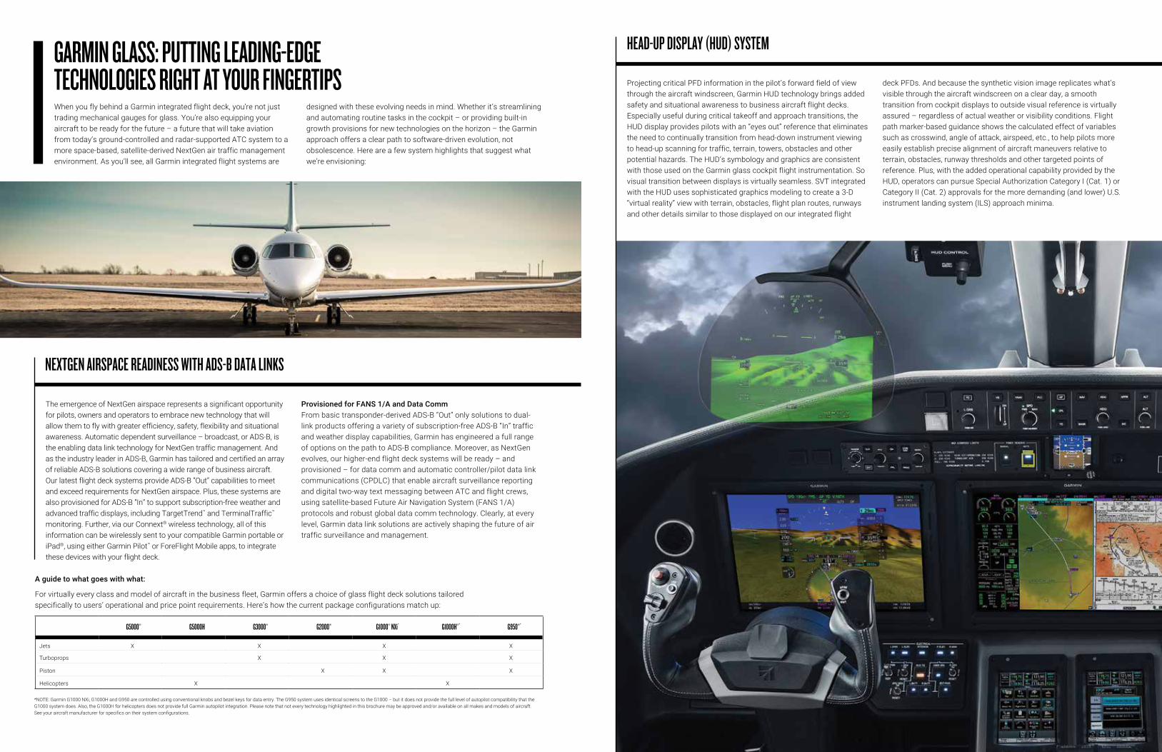
GARMIN GLASS: PUTTING LEADING-EDGE TECHNOLOGIES RIGHT AT YOUR FINGERTIPS Projecting critical PFD information in the pilot’s forward field of view
through the aircraft windscreen, Garmin HUD technology brings added safety and situational awareness to business aircraft flight decks. Especially useful during critical takeoff and approach transitions, the HUD display provides pilots with an “eyes out” reference that eliminates the need to continually transition from head-down instrument viewing to head-up scanning for traffic, terrain, towers, obstacles and other potential hazards. The HUD’s symbology and graphics are consistent with those used on the Garmin glass cockpit flight instrumentation. So visual transition between displays is virtually seamless. SVT integrated with the HUD uses sophisticated graphics modeling to create a 3-D “virtual reality” view with terrain, obstacles, flight plan routes, runways and other details similar to those displayed on our integrated flight
deck PFDs. And because the synthetic vision image replicates what’s visible through the aircraft windscreen on a clear day, a smooth transition from cockpit displays to outside visual reference is virtually assured – regardless of actual weather or visibility conditions. Flight path marker-based guidance shows the calculated effect of variables such as crosswind, angle of attack, airspeed, etc., to help pilots more easily establish precise alignment of aircraft maneuvers relative to terrain, obstacles, runway thresholds and other targeted points of reference. Plus, with the added operational capability provided by the HUD, operators can pursue Special Authorization Category I (Cat. 1) or Category II (Cat. 2) approvals for the more demanding (and lower) U.S. instrument landing system (ILS) approach minima.
HEAD-UP DISPLAY (HUD) SYSTEM
Providing the highly accurate height-above-terrain tracking needed for Class A TAWS terrain alerting, Category II ILS operations, TCAS II collision avoidance and other precision flight control functions, Garmin all-digital radar altimetry provides the robust surface-monitoring input your integrated flight deck system requires. Patented technology incorporates advanced built-in self-test monitors that continuously cross-check the data and system integrity to ensure an accurate measurement of your aircraft’s above-ground-level (AGL) altitude. This RadAlt data, when integrated with your system’s glass flight displays, conveniently puts your AGL readout right where you need it for optimum visibility in high-workload landing situations. So you can fly with greater confidence, knowing just how much room you have to maneuver between earth and sky.
PRECISION RADAR ALTIMETRY
G3000Honda Aircraft CompanyHondaJet
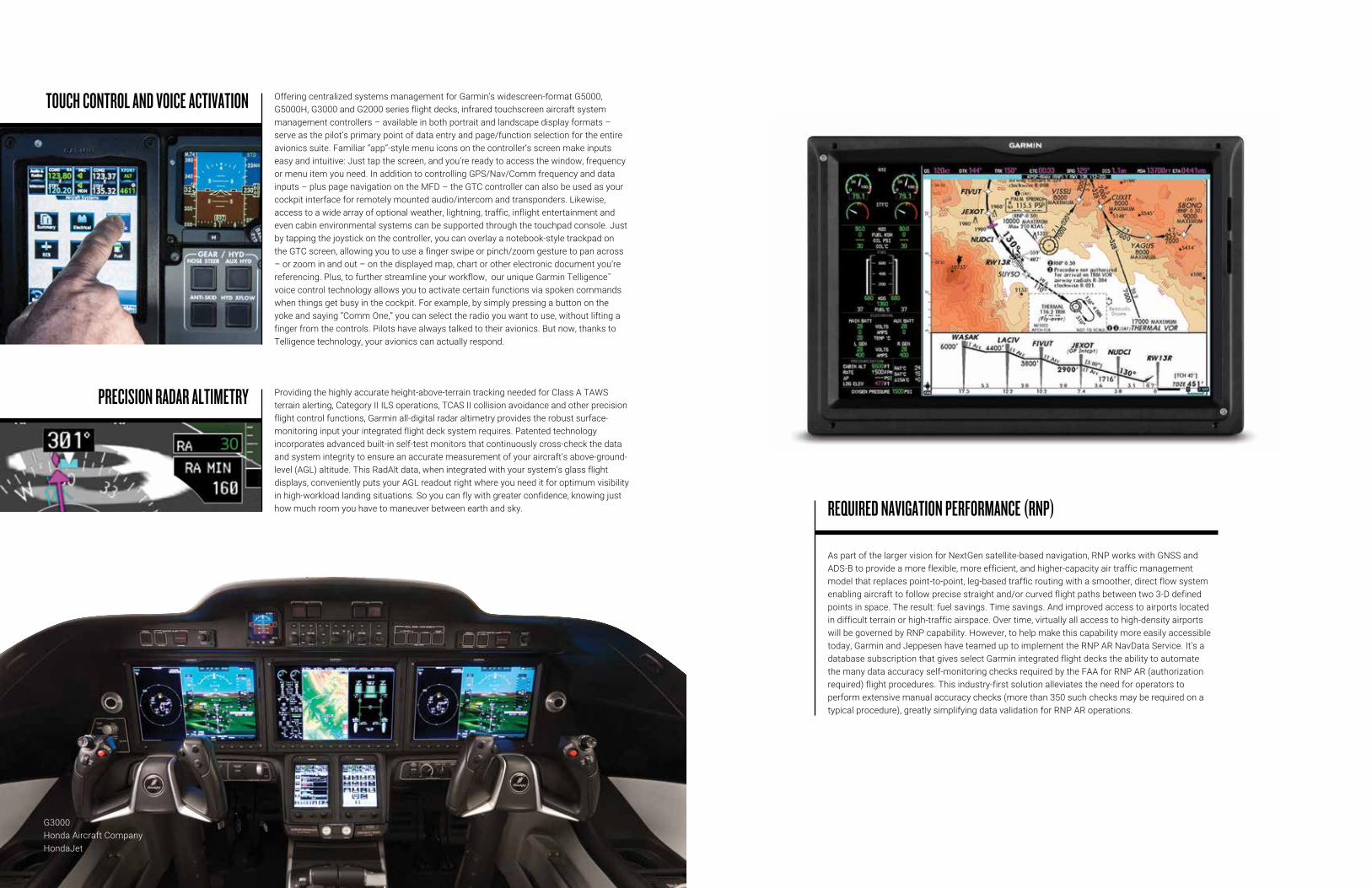
Offering centralized systems management for Garmin’s widescreen-format G5000, G5000H, G3000 and G2000 series flight decks, infrared touchscreen aircraft system management controllers – available in both portrait and landscape display formats – serve as the pilot’s primary point of data entry and page/function selection for the entire avionics suite. Familiar “app”-style menu icons on the controller’s screen make inputs easy and intuitive: Just tap the screen, and you’re ready to access the window, frequency or menu item you need. In addition to controlling GPS/Nav/Comm frequency and data inputs – plus page navigation on the MFD – the GTC controller can also be used as your cockpit interface for remotely mounted audio/intercom and transponders. Likewise, access to a wide array of optional weather, lightning, traffic, inflight entertainment and even cabin environmental systems can be supported through the touchpad console. Just by tapping the joystick on the controller, you can overlay a notebook-style trackpad on the GTC screen, allowing you to use a finger swipe or pinch/zoom gesture to pan across – or zoom in and out – on the displayed map, chart or other electronic document you’re referencing. Plus, to further streamline your workflow, our unique Garmin Telligence™ voice control technology allows you to activate certain functions via spoken commands when things get busy in the cockpit. For example, by simply pressing a button on the yoke and saying “Comm One,” you can select the radio you want to use, without lifting a finger from the controls. Pilots have always talked to their avionics. But now, thanks to Telligence technology, your avionics can actually respond.
TOUCH CONTROL AND VOICE ACTIVATION
As part of the larger vision for NextGen satellite-based navigation, RNP works with GNSS and ADS-B to provide a more flexible, more efficient, and higher-capacity air traffic management model that replaces point-to-point, leg-based traffic routing with a smoother, direct flow system enabling aircraft to follow precise straight and/or curved flight paths between two 3-D defined points in space. The result: fuel savings. Time savings. And improved access to airports located in difficult terrain or high-traffic airspace. Over time, virtually all access to high-density airports will be governed by RNP capability. However, to help make this capability more easily accessible today, Garmin and Jeppesen have teamed up to implement the RNP AR NavData Service. It’s a database subscription that gives select Garmin integrated flight decks the ability to automate the many data accuracy self-monitoring checks required by the FAA for RNP AR (authorization required) flight procedures. This industry-first solution alleviates the need for operators to perform extensive manual accuracy checks (more than 350 such checks may be required on a typical procedure), greatly simplifying data validation for RNP AR operations.
REQUIRED NAVIGATION PERFORMANCE (RNP)
Another safety-enhancing option available with your flight control package is the Garmin ESP™ system. This electronic monitoring and exceedance-correcting technology works to assist you in maintaining your aircraft in a safe, flight-stable condition – helping to prevent the onset of inadvertent stall/spins, overspeeds, steep spirals or other excursions beyond normal flight envelope parameters, should you become distracted, disoriented or incapacitated during flight. ESP functions independently of the aircraft’s autopilot system (although it does use the same control servos), so it basically operates “in the background” whenever you’re hand-flying the aircraft – gently nudging the controls back toward stable flight whenever pitch, roll or high-speed deviations exceed the recommended limits. ESP will then disengage when the aircraft returns to normal stabilized flight. The ESP system is designed to augment, not overpower, your control of the aircraft. Its inputs can be easily overridden manually. Yet, any pilot who’s ever been startled to attention by a stall warning horn or stick shaker in a busy cockpit will appreciate the compelling safety benefits of this “proactive prevention” technology from Garmin.
STABILITY ENHANCEMENT WITH ELECTRONIC STABILITY PROTECTION (ESP™)
To fully leverage the performance and capability of your aircraft, most factory-installed Garmin glass flight deck systems offer seamless integration with an advanced, AHRS-based AFCS engineered to provide the latest in flight director, autopilot, yaw damper and automatic/manual electric trim functionality. The system’s all-digital, dual-channel, fail-passive design ensures superior stability and control – delivering precise lateral and vertical navigation guidance for all phases of flight. Airspeed holds, VNAV profiles, automatic nav-to-nav captures, coupled holding patterns, procedure turns, go-arounds and more – the list of capabilities is unprecedented in this class of autopilot. You’ll appreciate the positive, consistent response afforded by airspeed-scheduled trim
– as well as the silky smooth roundouts and vertical intercepts that the system’s advanced software modeling provides on climbs and descents. What’s more, the system is fully enabled for satellite-based WAAS/SBAS guidance capability – supporting fully coupled GPS-only LPV approaches into runways that may not be served by ILS or other ground-based electronic approach aids. With WAAS/SBAS guidance, your Garmin AFCS can automatically fly any procedure published in the navigation database. So you’ll have access to more all-weather landing options at more airports throughout the world.
ADVANCED AUTOPILOT INTEGRATION
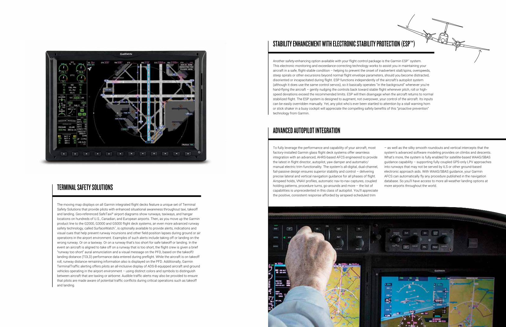
The moving map displays on all Garmin integrated flight decks feature a unique set of Terminal Safety Solutions that provide pilots with enhanced situational awareness throughout taxi, takeoff and landing. Geo-referenced SafeTaxi® airport diagrams show runways, taxiways, and hangar locations on hundreds of U.S., Canadian, and European airports. Then, as you move up the Garmin product line to the G2000, G3000 and G5000 flight deck systems, an even more advanced runway safety technology, called SurfaceWatch™, is optionally available to provide alerts, indications and visual cues that help prevent runway incursions and other field-position lapses during ground or air operations in the airport environment. Examples of such alerts include taking off or landing on the wrong runway. Or on a taxiway. Or on a runway that’s too short for safe takeoff or landing. In the event an aircraft is aligned to take off on a runway that is too short, the flight crew is given a brief “runway too short” aural annunciation and a visual message on the PFD, based on the takeoff/landing distance (TOLD) performance data entered during preflight. While the aircraft is on takeoff roll, runway distance remaining information also is displayed on the PFD. Additionally, Garmin TerminalTraffic alerting offers pilots an all-inclusive display of ADS-B equipped aircraft and ground vehicles operating in the airport environment – using distinct colors and symbols to distinguish between aircraft that are taxiing or airborne. Audible traffic alerts may also be provided to ensure that pilots are made aware of potential traffic conflicts during critical operations such as takeoff and landing.
TERMINAL SAFETY SOLUTIONS
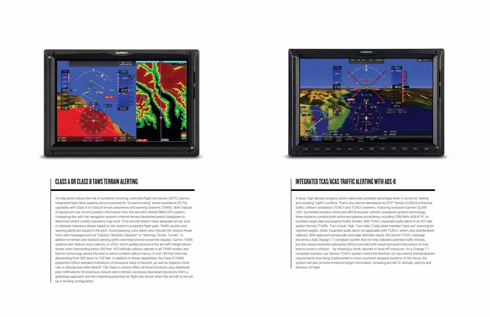
To help pilots reduce the risk of accidents involving controlled flight into terrain (CFIT), Garmin integrated flight deck systems are provisioned for “forward-looking” terrain avoidance (FLTA) capability with Class A or Class B terrain awareness and warning systems (TAWS). Both classes of equipment use current position information from the aircraft’s WAAS/SBAS GPS system, comparing this with the navigation system’s internal terrain/obstacles/airport databases to determine where conflict scenarios may exist. If the aircraft doesn’t have adequate terrain and/or obstacle clearance ahead, based on the system’s projected flight path, TAWS caution and warning alerts are issued to the pilot. Accompanying voice alerts also indicate the relative threat level, with messages such as “Caution, Obstacle, Obstacle” or “Warning, Terrain, Terrain.” In addition to terrain and obstacle alerting (with color-keyed terrain proximity display), Garmin TAWS systems also feature voice callouts, or VCOs, which audibly announce the aircraft’s height above terrain when descending below 500 feet. VCO altitude callouts operate in all TAWS modes, and Garmin technology allows the pilot to select multiple callout menus, in one 100-foot intervals, descending from 500 down to 100 feet. In addition to these capabilities, the Class B TAWS equipment offers standard indications of excessive rates of descent, as well as negative climb rate or altitude loss after takeoff. The Class A version offers all these functions, plus additional pilot notifications for excessive closure rate to terrain, excessive downward deviations from a glideslope approach and the impending potential for flight into terrain when the aircraft is not set up in landing configuration.
CLASS A OR CLASS B TAWS TERRAIN ALERTING
In busy, high-density airspace, pilots need every possible advantage when it comes to “seeing and avoiding” traffic conflicts. That’s why Garmin developed its GTS™ family of ADS-B enhanced traffic collision avoidance (TCAS II and TCAS I) systems. Featuring exclusive Garmin CLEAR CAS™ (correlated location enhanced ADS-B receiver collision avoidance system) technology, these systems combine both active and passive surveillance, including 1090 MHz ADS-B “In”, to correlate target data and pinpoint traffic threats. With TCAS I, expanded audio alerts in an ATC-like spoken format (“Traffic. Two o’clock. High. Two miles.”) help pilots maintain “eyes out” scanning for reported targets. (Note: Expanded audio alerts not applicable with TCAS II, which uses standardized callouts). With approved transponder and radar altimeter inputs, the Garmin TCAS II package becomes a fully Change 7.1 compliant system that not only indicates potential traffic threats, but also issues resolution advisories (RAs) to provide both visual and aural instructions on how best to avoid a collision – by initiating a climb, descent or level-off maneuver. As a Change 7.1 compliant solution, our Garmin TCAS II system meets the NextGen (or equivalent) standardization requirements now being implemented in most countries’ airspace systems. In the future, the system will also provide enhanced target information, including aircraft ID, altitude, velocity and direction of flight.
INTEGRATED TCAS/ACAS TRAFFIC ALERTING WITH ADS-B
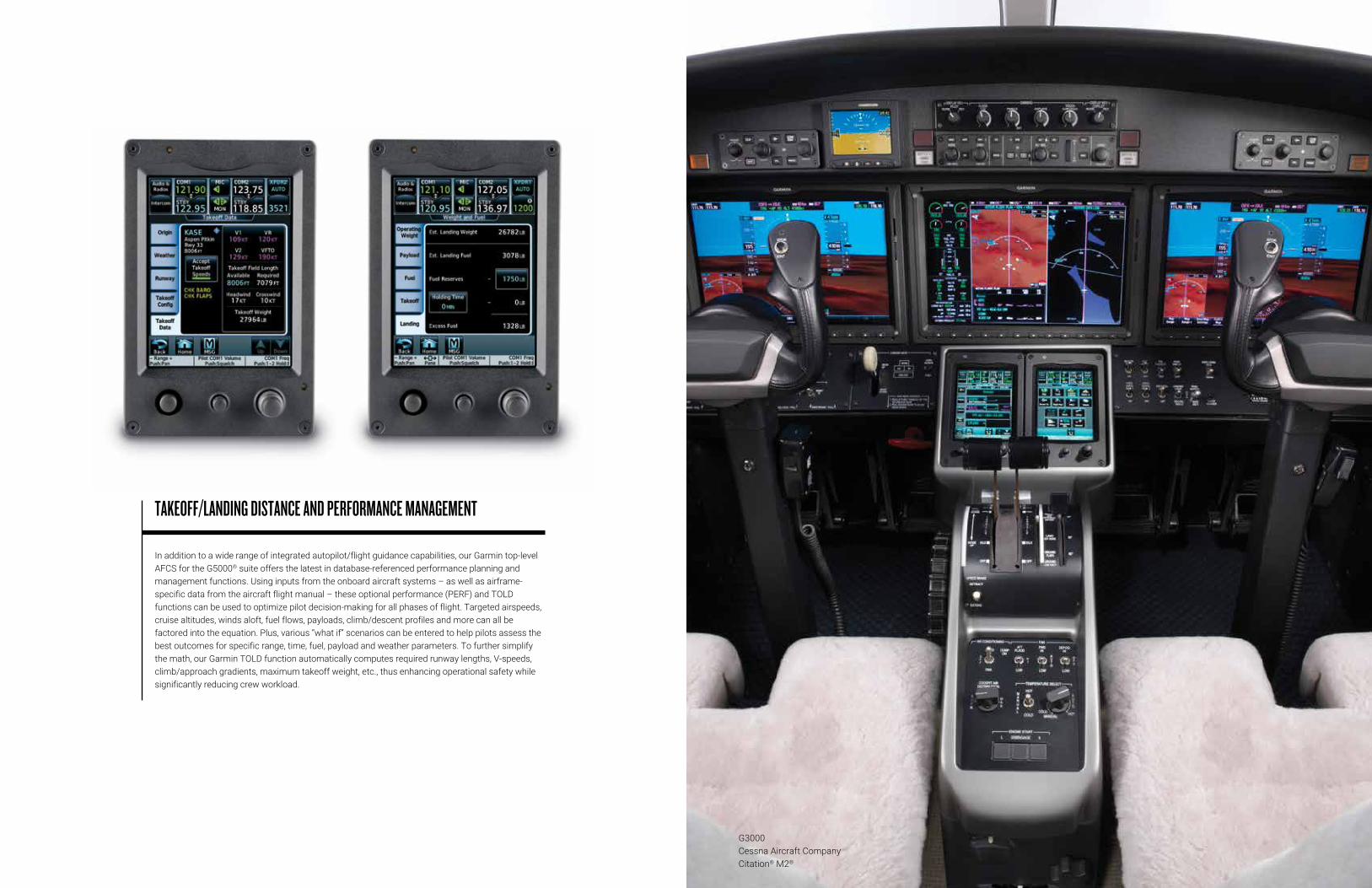
In addition to a wide range of integrated autopilot/flight guidance capabilities, our Garmin top-level AFCS for the G5000® suite offers the latest in database-referenced performance planning and management functions. Using inputs from the onboard aircraft systems – as well as airframe-specific data from the aircraft flight manual – these optional performance (PERF) and TOLD functions can be used to optimize pilot decision-making for all phases of flight. Targeted airspeeds, cruise altitudes, winds aloft, fuel flows, payloads, climb/descent profiles and more can all be factored into the equation. Plus, various “what if” scenarios can be entered to help pilots assess the best outcomes for specific range, time, fuel, payload and weather parameters. To further simplify the math, our Garmin TOLD function automatically computes required runway lengths, V-speeds, climb/approach gradients, maximum takeoff weight, etc., thus enhancing operational safety while significantly reducing crew workload.
TAKEOFF/LANDING DISTANCE AND PERFORMANCE MANAGEMENT
G3000Cessna Aircraft CompanyCitation® M2®
G1000® NXi UpgradeKing Air Family
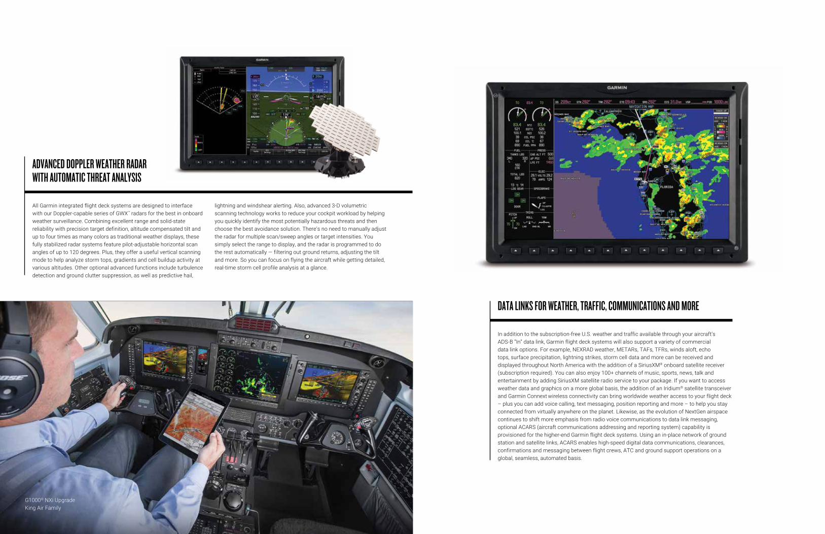
All Garmin integrated flight deck systems are designed to interface with our Doppler-capable series of GWX™ radars for the best in onboard weather surveillance. Combining excellent range and solid-state reliability with precision target definition, altitude compensated tilt and up to four times as many colors as traditional weather displays, these fully stabilized radar systems feature pilot-adjustable horizontal scan angles of up to 120 degrees. Plus, they offer a useful vertical scanning mode to help analyze storm tops, gradients and cell buildup activity at various altitudes. Other optional advanced functions include turbulence detection and ground clutter suppression, as well as predictive hail,
lightning and windshear alerting. Also, advanced 3-D volumetric scanning technology works to reduce your cockpit workload by helping you quickly identify the most potentially hazardous threats and then choose the best avoidance solution. There’s no need to manually adjust the radar for multiple scan/sweep angles or target intensities. You simply select the range to display, and the radar is programmed to do the rest automatically — filtering out ground returns, adjusting the tilt and more. So you can focus on flying the aircraft while getting detailed, real-time storm cell profile analysis at a glance.
ADVANCED DOPPLER WEATHER RADAR WITH AUTOMATIC THREAT ANALYSIS
In addition to the subscription-free U.S. weather and traffic available through your aircraft’s ADS-B “In” data link, Garmin flight deck systems will also support a variety of commercial data link options. For example, NEXRAD weather, METARs, TAFs, TFRs, winds aloft, echo tops, surface precipitation, lightning strikes, storm cell data and more can be received and displayed throughout North America with the addition of a SiriusXM® onboard satellite receiver (subscription required). You can also enjoy 100+ channels of music, sports, news, talk and entertainment by adding SiriusXM satellite radio service to your package. If you want to access weather data and graphics on a more global basis, the addition of an Iridium® satellite transceiver and Garmin Connext wireless connectivity can bring worldwide weather access to your flight deck – plus you can add voice calling, text messaging, position reporting and more – to help you stay connected from virtually anywhere on the planet. Likewise, as the evolution of NextGen airspace continues to shift more emphasis from radio voice communications to data link messaging, optional ACARS (aircraft communications addressing and reporting system) capability is provisioned for the higher-end Garmin flight deck systems. Using an in-place network of ground station and satellite links, ACARS enables high-speed digital data communications, clearances, confirmations and messaging between flight crews, ATC and ground support operations on a global, seamless, automated basis.
DATA LINKS FOR WEATHER, TRAFFIC, COMMUNICATIONS AND MORE
Using Bluetooth®-enabled Garmin Connext onboard link technology — via one of our Flight Stream series of wireless gateways in the aircraft — pilots can now enjoy more freedom and flexibility in everything from preflight planning and database management to inflight decision-making. With the appropriate data link installed, Garmin Connext lets you access quality on-demand weather updates, text/voice communications and more. Plus, you can stream information in real time between your avionics and compatible mobile devices running the Garmin Pilot or ForeFlight mobile apps — turning your tablet, smartphone or compatible aviation portable into a true cockpit interface. You can also use your mobile device to create flight plans whenever and wherever it’s convenient and
then easily transfer the data to your avionics once you get to the airport. Database Concierge capability further allows Garmin Pilot to wirelessly update the aviation databases of your compatible avionics. At home, you simply select the individual databases on Garmin Pilot, download them and store them to your mobile device. Then at the airport, once your device establishes a wireless connection in the airplane, Garmin Pilot will transfer your up-to-date databases directly to the compatible avionics in minutes, where they’ll wait in standby until their effective dates. This app-to-avionics interface saves you valuable time and tedious data entry, so you can complete your checklist items quicker and get airborne sooner.
GARMIN CONNEXT WIRELESS ECOSYSTEM
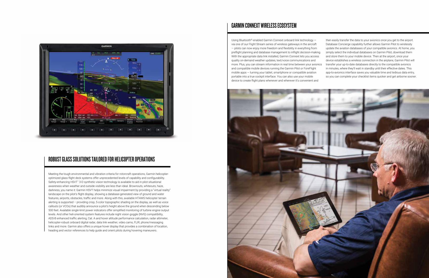
Meeting the tough environmental and vibration criteria for rotorcraft operations, Garmin helicopter-optimized glass flight deck systems offer unprecedented levels of capability and configurability. Safety-enhancing HSVT™ 3-D synthetic vision technology is available to aid in pilot situational awareness when weather and outside visibility are less than ideal. Brownouts, whiteouts, haze, darkness, you name it: Garmin HSVT helps minimize visual impairment by providing a “virtual reality“ landscape on the pilot’s flight display, showing a database-generated view of ground and water features, airports, obstacles, traffic and more. Along with this, available HTAWS helicopter terrain alerting is supported – providing crisp, 5-color topographic shading on the display, as well as voice callouts (or VCOs) that audibly announce a pilot’s height above the ground when descending below 500 feet. Available single-limit power indicators offer simplified monitoring of turbine engine output levels. And other heli-oriented system features include night vision goggle (NVG) compatibility, ADS-B enhanced traffic alerting, Cat. A and hover altitude performance calculation, radar altimeter, helicopter-robust onboard digital radar, data link weather, video cams, FLIR, phone/messaging links and more. Garmin also offers a unique hover display that provides a combination of location, heading and vector references to help guide and orient pilots during hovering maneuvers.
ROBUST GLASS SOLUTIONS TAILORED FOR HELICOPTER OPERATIONS