Embed Size (px)
Citation preview


Integrated Geospatial Information
Framework in Serbia in support of
Government priority areas
Darko Vučetić, Republic geodetic authority

Republic Geodetic Authority
Serbian Government
MinistriesSpecial Governmental
Organizations
Ministry of
Construction,
Transport and
Infrastructure
Republic Geodetic Authority
6 Sectors
Real-estate Cadastre Offices
- 170
Republic level
Municipal level
By the official Law on state survey and cadaster RGA is national
geospatial data provider responsible for:
✓ NSDI;
✓ Geodetic Reference Systems;
✓ State Survey;
✓ Real-estate cadastre;
✓ Utillity cadastre;
✓ Registry of administrative Units;
✓ Addresses Registry;
✓ Topography and Cartography;
✓ Real-estate Mass Valuation;
✓ Registry of Geographic Names;
✓ Professional supervision and licensing of geodetic organizations;
✓ Geomagnetism and aeronomy;
✓ ....

Address register (2015)
• Population: 7,020,858
• 2.676.898 citizens leave in street without name and house number
• 3.028.020 citizens leave in street without house number
• 6.500 streets are not registered - estimation

Real Estate Cadastre
• Over 4,5 millions buildings are not registered!!!

Status
Data are outdated
Heterogeneity of IT infrastructures
Duplication-cost and efforts
Lack of standards
Low accessibility
Data sharing not functional
Unclear regulation and licences
No coordination
Others – lack of technical knowledge, limited financial and human capacities….

NICE FACADE. BAD INFRASTRUCTURE!!!
Sourse: The Economist Јул 2003
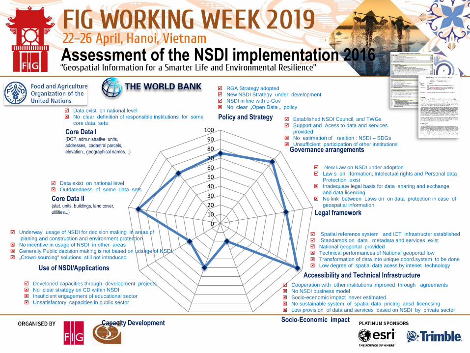
Assessment of the NSDI implementation 2016
0
10
20
30
40
50
60
70
80
90
100
Socio-Economic impact
Accessibility and Technical Infrastructure
Legal framework
Governance arrangements
Policy and Strategy
Core Data I(DOP, adm.nistrative units,
addresses, cadastral parcels,
elevation., geographical names…)
Core Data II(stat. units, buildings, land cover,
utilities...)
Use of NSDI/Applications
Capacity Development
RGA Strategy adopted
New NSDI Strategy under development
NSDI in line with e-Gov
No clear „Open Data „ policy
Established NSDI Council, and TWGs
Support and Acess to data and services
provided
No estimation of realtion : NSDI – SDGs
Unsufficient participation of other institutions
New Law on NSDI under adoption
Law s on Iformation, Intelectual rights and Personal data
Protection exist
Inadequate legal basis for data sharing and exchange
and data licencing
No link between Laws on on data protection in case of
geospatial information
Spatial reference system and ICT infrastructer established
Standarsds on data , metadata and services exist
National geoportal provided
Technical performances of National geoportal low
Transformation of data into unique coord.system to be done
Low degree of spatial data acess by intenet technology
Cooperation with other institutions improved through agreements
No NSDI business model
Socio-ecenomic impact never estimated
No sustainable system of spatial data pricing ansd licencsing
Low provision of data and services based on NSDI by private sector
Developed capacities through development projects
No clear strategy on CD within NSDI
Insuficient engagement of educational sector
Unsatisfactory capacities in public sector
Underway usage of NSDI for decision making in areas of
planing and construction and environment protection
No incentive in usage of NSDI in other areas
Generally Public decision making is not based on udsage of NSDI
„Crowd-sourcing“ solutions still not introduced
Data exist on national level
No clear definition of responsible institutions for some
core data sets
Data exist on national level
Outdatedness of some data sets


RGA Strategy 2016-2020
The overall goal - support the economic reform of the Government by
effective provision of information in the sphere of real-estate and geospatial
related activities for the fast, easy and rightfull decision-making at all
strategic levels.VISION
The Republic Geodetic Authority will provide reliable and updated geospatial and property data, in a standardized
and readily accessible manner, for the purpose of sustainable social and economic development of the Republic of
Serbia.MISSION
The Republic Geodetic Authority is a respectable public
service attending to citizens, economy, and state, adjusting
its operation, volume, and quality of services and data to
the international standards and norms, as well as with user
requirements noted.
The Republic Geodetic Authority is a governmental
institution competent for the official national register of
properties and property rights holders.
The Republic Geodetic Authority is a governmental
institution competent for providing services in the domain
of geospatial data management for the purposes of society
and state, actively participating and assisting other
governmental organs to implement activities aimed at
meeting pre-accession commitments in the Republic of
Serbia European integration process.

Legal framework
• Law on National Spatial Data Infrustructure (2018)
• Law on Procedures for Real Estate and Utility Cadaster Registration (2018)
• Law on eGovernment (2018)
• Law on spatial planning (2018)
• Law on DRMR (2018)
• Law on Administrative fees (2017)
• ……
• By-law on Address Register (2017)
• By-law on Internal organization and work places in RGA (2017)
• ……
Legal framework
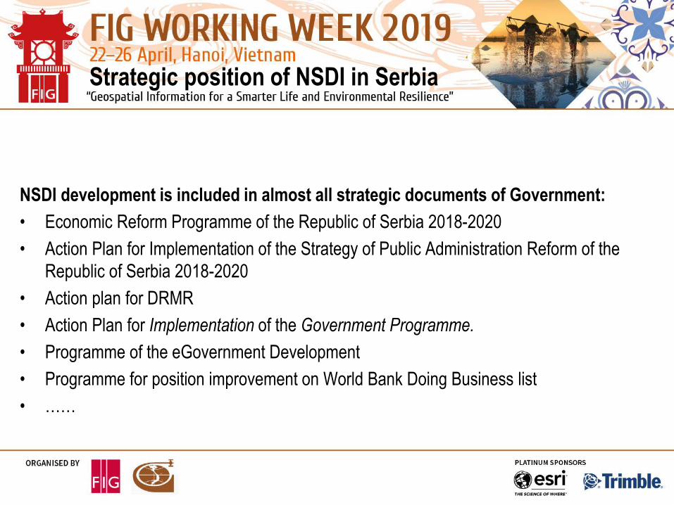
Strategic position of NSDI in Serbia
NSDI development is included in almost all strategic documents of Government:
• Economic Reform Programme of the Republic of Serbia 2018-2020
• Action Plan for Implementation of the Strategy of Public Administration Reform of the
Republic of Serbia 2018-2020
• Action plan for DRMR
• Action Plan for Implementation of the Government Programme.
• Programme of the eGovernment Development
• Programme for position improvement on World Bank Doing Business list
• ……
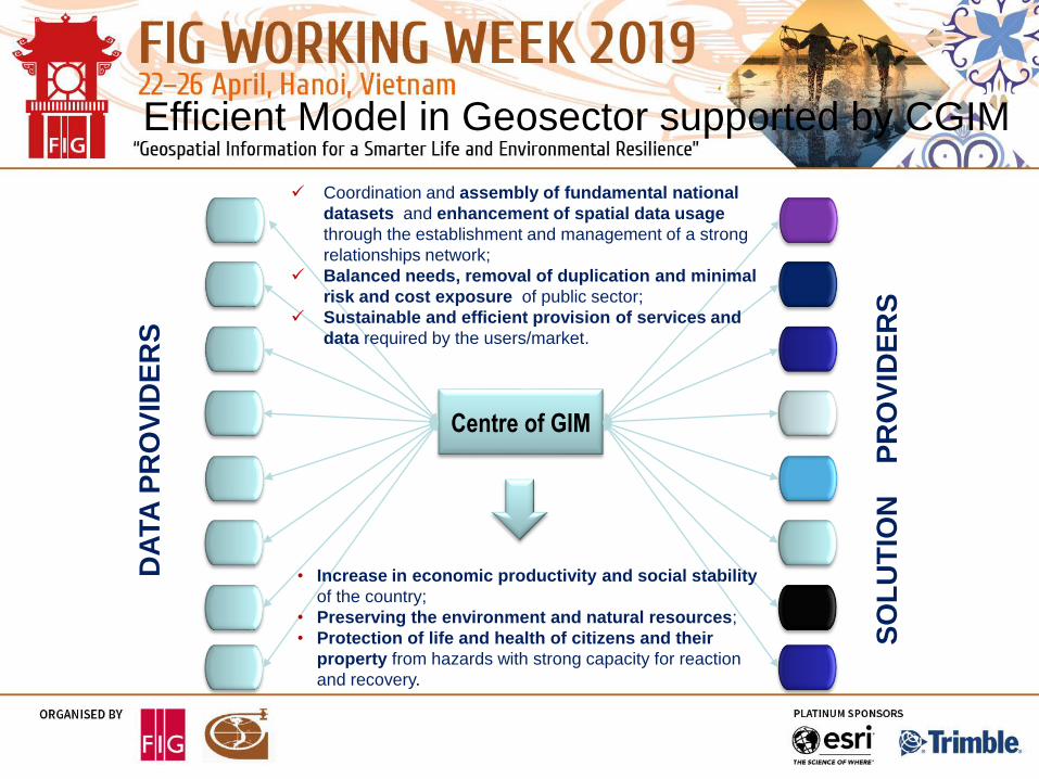
Centre of GIM
DA
TA
PR
OV
IDE
RS
SO
LU
TIO
N P
RO
VID
ER
S
Efficient Model in Geosector supported by CGIM
✓ Coordination and assembly of fundamental national
datasets and enhancement of spatial data usage
through the establishment and management of a strong
relationships network;
✓ Balanced needs, removal of duplication and minimal
risk and cost exposure of public sector;
✓ Sustainable and efficient provision of services and
data required by the users/market.
• Increase in economic productivity and social stability
of the country;
• Preserving the environment and natural resources;
• Protection of life and health of citizens and their
property from hazards with strong capacity for reaction
and recovery.
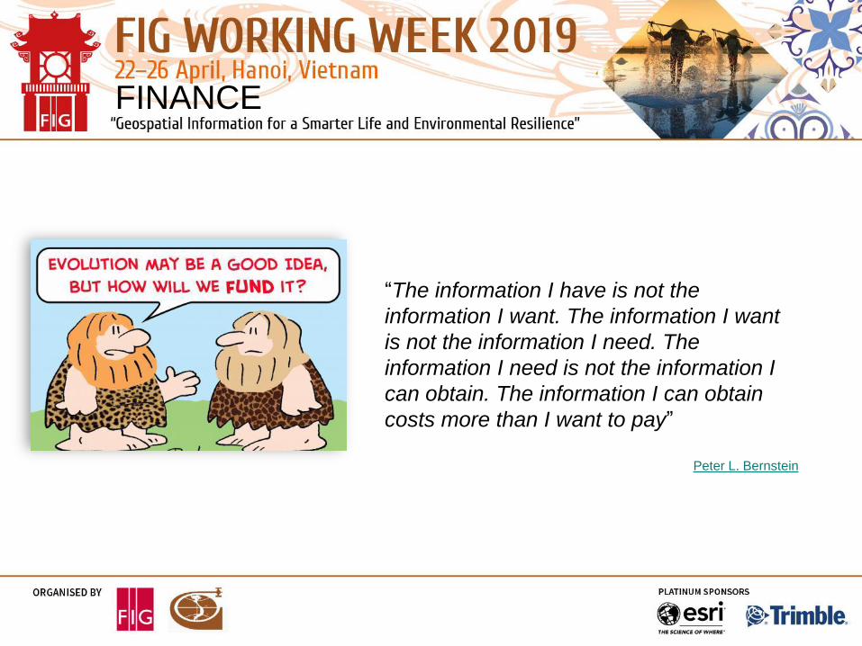
“The information I have is not the
information I want. The information I want
is not the information I need. The
information I need is not the information I
can obtain. The information I can obtain
costs more than I want to pay”
Peter L. Bernstein
FINANCE
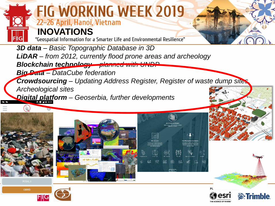
INOVATIONS
3D data – Basic Topographic Database in 3D
LiDAR – from 2012, currently flood prone areas and archeology
Blockchain technology – planned with UNDP
Big Data – DataCube federation
Crowdsourcing – Updating Address Register, Register of waste dump sites,
Archeological sites
Digital platform – Geoserbia, further developments

1
6
“a plug-and-play business model that allows multiple participants (producers and consumers)
to connect to it, interact with each other and create and exchange value. Also collections of
services used for hosting, processing and distributing geospatial data are called platforms.”
GEOSRBIJA - GEOSPATIAL PLATFORM
Key components of the platform: Data standardisation – data schemas, quality rules, life-cycle rules, collection
guidelines
Automated Data tools for the producers – quality quard, data life-cycle
management, error reporting, data updating tools
Data portal – finding, evaluating data – situational picture, metadata search,
quality dashboards
Data distribution services, APIs, Analysis and processing services
Support (community)
Management of the ecosystem

GEOSERBIA - GEOSPATIAL PLATFORM

Collaborative platform
Services

Improved performances/“user
familiar“ interface
Based on Open Source solutions (MapServer, Lucene, Open Leyers,
Sencha...)
Improved search/indexin
More data/2 levels of access
Download data/Customised reports
Digitalization/simple analysis
WMS/WFS functionality
Edit /collect data
Import external WEB sevices and
data/media files
Print/Save File/Embed map
Users with dedicated permissions can
easily set up new clients, defining
their content, functionality, user
interface etc.
New national geoportal GeoSrbija– WebGIS solution http://a3.geosrbija.rs/
Metadata Catalogue Service published http://metakatalog.geosrbija.rs/geonetwork/
NSDI DIGITAL PLATFORM

Digitalization
Simbology
Media attachment (pictures, video,
text files)
Editing existing data
Login/Authentification layer
Colaborative work
Crowd Sourcing functionality
Collect and create new data sets
Link with data owners
Export Files
Import external web services
Import external data (link with Open
Data portal)
Users with dedicated permissions can
easily set up new clients, defining
their content, functionality, user
interface etc.
Colaborative work – crowdSDI desktop solution http://a3.geosrbija.rs/
NSDI DIGITAL PLATFORM

Technology
Pope inauguration
Source: Rumyana Tonchovska, UN FAO

Crowdsourcing
• The developed global reporting mechanism (UNSTATS, 2018) pointed to the need for data
generated by civil society to be incorporated into the international process of monitoring
and achieving the sustainable development goals.
• “Countries around the world will have to support projects that promote public participation in
measuring progress towards the sustainable development goals.”
• Crowdsourcing is a part of broader trends in the creation of "user content" and the way to
collect new and update existing geospatial data
• Large resource in the work of the state administration for making strategic decisions as well
as managing strategic resources among which the environment certainly has a significant
place.
• It is necessary to establish a whole set of rules, organizational and legal framework, and to
provide technical preconditions and procedures for the functional integration of the data
thus collected by Crowdsourcing into the National Spatial Data Infrastructure of a country

Crowdsourcing
Mobile app for crowdsoursing
Android and iOS
Geolocation and secure
connection
Verification of collected data
Location, time, wheather
conditions
Offline mode
Crowd Sourcing functionality
Link with geoSrbija
Link with data owners
Users with dedicated
permissions can easily set up
new clients, defining their
content, functionality, user
interface etc.
Mobile App – crowdSDI
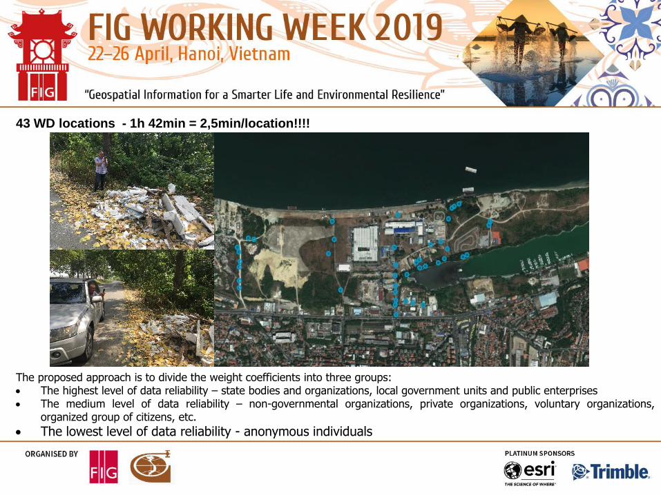
43 WD locations - 1h 42min = 2,5min/location!!!!
The proposed approach is to divide the weight coefficients into three groups:• The highest level of data reliability – state bodies and organizations, local government units and public enterprises• The medium level of data reliability – non-governmental organizations, private organizations, voluntary organizations,
organized group of citizens, etc.
• The lowest level of data reliability - anonymous individuals

Address Register
1,5 YEAR = UPDATED ADRESS REGISTER!!
Geosrbija for street system
crowdSDI for demarcation of house numbers
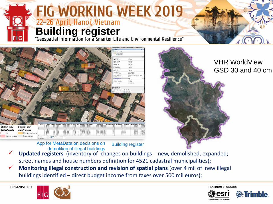
Building register
✓ Updated registers (inventory of changes on buildings - new, demolished, expanded; street names and house numbers definition for 4521 cadastral municipalities);
✓ Monitoring illegal construction and revision of spatial plans (over 4 mil of new illegal buildings identified – direct budget income from taxes over 500 mil euros);
App for MetaData on decisions on
demolition of illegal buildingsBuilding register
VHR WorldView
GSD 30 and 40 cm
NSDI DIGITAL PLATFORM
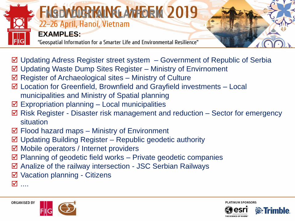
Updating Adress Register street system – Government of Republic of Serbia
Updating Waste Dump Sites Register – Ministry of Envirnoment
Register of Archaeological sites – Ministry of Culture
Location for Greenfield, Brownfield and Grayfield investments – Local
municipalities and Ministry of Spatial planning
Expropriation planning – Local municipalities
Risk Register - Disaster risk management and reduction – Sector for emergency
situation
Flood hazard maps – Ministry of Environment
Updating Building Register – Republic geodetic authority
Mobile operators / Internet providers
Planning of geodetic field works – Private geodetic companies
Analize of the railway intersection - JSC Serbian Railways
Vacation planning - Citizens
....
EXAMPLES:

0
10
20
30
40
50
60
70
80
90
100
Socio-Economic impact
Accessibility and Technical
Infrastructure
Legal framework
Governance arrangements
Policy and Strategy
Core Data I
Core Data II
Use of
NSDI/Applications
Capacity Development
Status 2016 vs 2019