Embed Size (px)
Citation preview

The U.S. Air Force and the U.S. Marine Corps are updating the Integrated Natural Resources Management Plans for:
• Barry M. Goldwater Range• Luke Air Force Base, including
Auxiliary Field #1 and Fort Tuthill• Marine Corps Air Station Yuma
Military lands often contain some of the most significant remaining large tracts of valuable resources. Sound management of natural resources ensures that military activities can be conducted in a sustainable manner over the long term.
The Integrated Natural Resources Management Plan (INRMP) is the primary tool for managing a military installation's natural resources (Sikes Act, 16 USC § 670 et. Seq). An INRMP assists the Installation Commander with the conservation and rehabilitation of natural resources consistent with the use of the installation to ensure the readiness of the Armed Forces (AFI 32-7064).
Integrated NaturalResources Management Plans
Public Scoping MeetingsThere will be two additional public meeting opportunities in March 2018 in Ajo and Yuma, Arizona.
Tuesday, March 13th, 2018, 5:30 –7:30 PMInternational Sonoran Desert Alliance (ISDA)Learning Center401 W Esperanza AvenueAjo, AZ 85321
Wednesday, March 14th, 2018, 5:30 –7:30 PMYuma County Library DistrictMain Library2951 S 21st DriveYuma, AZ 85364
The Air Force and Marine Corps welcome your input. You can participate by:1) Attend a public scoping meeting to learn more and talk
with Air Force and Marine Corps representatives.2) Review the draft Public Report (available February
20th, 2018) that describes changes in land conditions, summarizes current military use of the lands since the 2012 Public Report, and efforts related to management of natural and cultural resources and environmental remediation of the lands during the previous five years.
3) Submit comments via email to: [email protected]
Comments must be received by Wednesday, March 21st,2018, for consideration in the Draft Public Report for theINRMP update.

INRMP Activities at BMGRProject Highlights
– Anthropogenic Impact Study– Avian Studies– Invasive Species Control– Weather Monitoring– Wildlife Monitoring Using Remote Cameras– Road Marking– Public Outreach
Management Outlook 2018-2023
– Support Protected Species Recovery– Vegetation Inventory– Evaluate Erosion Conditions of Range Roads– Address Issues of Trespass Livestock– Surveys and Monitoring of Important Desert Species
BMGR INRMP Update– What is an INRMP?– What Does an INRMP Do?– Who are the Stakeholders?– How do I participate?
Integrated Natural Resources Management Plan (INRMP)

What is an INRMP?
What Does an INRMP Do?
An INRMP is a planning document that outlines how an installation with natural resources will manage those resources, while integrating military mission requirements, environmental and master planning documents, cultural resources, and outdoor recreation.
During the process of reviewing information and developing an INRMP, an installation looks holistically at the natural resources on a landscape or ecosystem level. Resources do not stop at a boundary, so it is important to include neighboring land agencies (e.g., state and federal) who share common resources. INRMPs guide annual program goals and daily natural resources management actions. They are living documents that are reviewed annually and comprehensively updated every five years.
• Defines an installation’s natural resources goals and objectives
• Ensures no net loss in capability to support the military mission
• Sustains natural resources and minimizes impacts
• Identifies and manages resources for designated and proposed threatened or endangered species and critical habitat in accordance with the Endangered Species Act (ESA) (16 USC Sections (§§) 1531-1544
• Supports hunting, fishing, and other natural resources-based outdoor recreation activities
• Provides a mechanism to obtain funds for natural resources projects
• Promotes projects to enhance and restore habitat to support wildlife and plants
• Supports safety programs such as Bird/Wildlife Aircraft Strike Hazard and willdland fire
• Identifies unique/important biological resources and establishes a program for habitat conservation and management
• Provides the public insight to natural resources management on military lands

INRMPs and YouWho are the Stakeholders?
How do I participate?
INRMPs are prepared in cooperation with the U.S. Fish and Wildlife Service, the state fish and wildlife agency (Arizona Game and Fish Department), and the military component (e.g., training managers, environmental managers, master planning staff, cultural resources managers, installation pest management professionals).
Another important participant is the public (e.g., recreational groups/users, surrounding community members), who utilize the range for outdoor recreation activities. Public input is vital to the planning process and public insight can help to guide an installations goals and objectives.
The public is invited to review the initial draft of the Public Report that describes changes in military use, environmental conditions, and public access opportunities that have occurred since the 2012 INRMP update. The report also provides a description of the natural resources projects planned for the next five-year planning period, 2018 –2023.
The draft Public Report will be available for the public to review and comment for a 30 day period, 20 February, 2018 –21 March, 2018. The draft Public Report can be accessed at:
http://www.luke.af.mil/
Public comments related to the draft Public Report can be submitted by emailing [email protected].
There will be two public meetings to allow the public to meet with the BMGR installation managers, ask questions, and to discuss natural resources program accomplishments and upcoming projects.
Contact: [email protected]
13 March, 20185:30 –7:30 PMInternational Sonoran Desert Alliance (ISDA)Learning Center401 W Esperanza AvenueAjo, AZ 85321
14 March, 20185:30 –7:30 PMYuma County Library DistrictMain Library2951 S 21st DriveYuma, AZ 85364

BMGR INRMP UPDATEProject Highlights
Anthropogenic Impact Study
Monitoring Wildlife by Remote Camera
Weather Monitoring Program
Invasive Species Control
Avian Studies
Road Marking and Public Outreach
Assess the impacts to soil resources related to transportation corridors and visitor use.
Remote cameras record wildlife use of artificial and natural rock catchments (also known as tinajas).
The wildlife monitoring program helps to identify individual species, assess population sizes, and collect information about various aspects of a species' ecology and behavior.
Maintain research grade Campbell Scientific weather stations and Onset weather stations to provide data for spatial interpolation of rainfall and temperature for BMGR and the wider region.
• Monitor invasive species using a GIS Cloud based application to document species presence and allow for targeted control efforts.
• Implement the integrated pest management program to control invasive species through a combination of removing plants and herbicide application.
Continue avian studies with conservation and management philosophies that emphasize:• Improving knowledge of species-
at-risk on BMGR East and the surrounding region.
• Monitoring the breeding bird community over the long-term at a landscape scale.
• Reducing the Bird/Animal Aircraft Strike Hazard.
Facilitate public recreational activities through:• A bird checklist for birding enthusiasts.• A public brochure and map detailing
– Public use roads– Range rules (for camping, firewood
collection, hunting, etc.)• An informational video for visitors that
addresses safety and environmental awareness.
• Maintenance of signs, gates, and fences to support road infrastructure and public access.
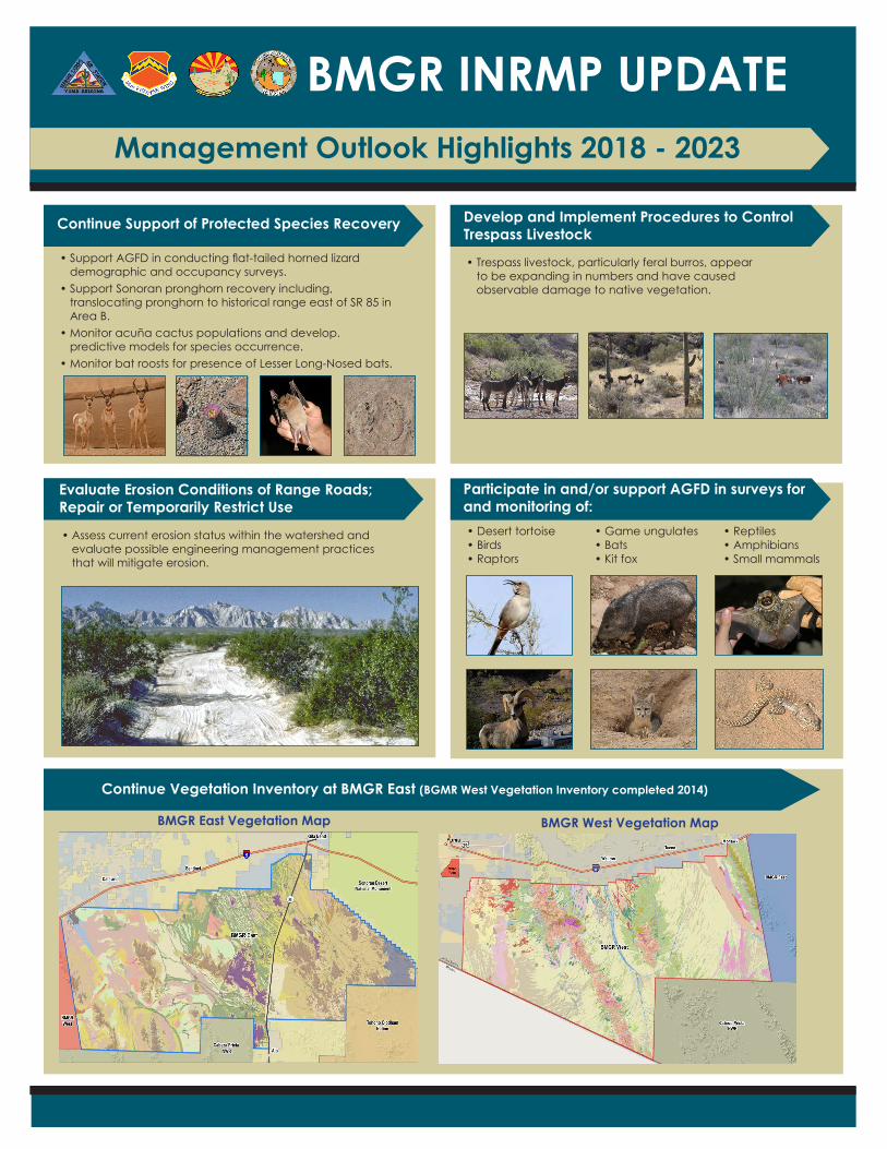
Continue Support of Protected Species Recovery
Participate in and/or support AGFD in surveys for and monitoring of:
Continue Vegetation Inventory at BMGR East (BGMR West Vegetation Inventory completed 2014)
Develop and Implement Procedures to Control Trespass Livestock
Evaluate Erosion Conditions of Range Roads; Repair or Temporarily Restrict Use
• Support AGFD in conducting flat-tailed horned lizard demographic and occupancy surveys.
• Support Sonoran pronghorn recovery including, translocating pronghorn to historical range east of SR 85 in Area B.
• Monitor acuña cactus populations and develop. predictive models for species occurrence.
• Monitor bat roosts for presence of Lesser Long-Nosed bats.
• Desert tortoise• Birds• Raptors
• Game ungulates• Bats• Kit fox
• Reptiles• Amphibians• Small mammals
• Trespass livestock, particularly feral burros, appear to be expanding in numbers and have caused observable damage to native vegetation.
• Assess current erosion status within the watershed and evaluate possible engineering management practices that will mitigate erosion.
CiteAGFD
CiteLukeAFBA.Alvidrez
BMGR INRMP UPDATEManagement Outlook Highlights 2018 - 2023
BMGR East Vegetation Map BMGR West Vegetation Map