Embed Size (px)
Citation preview
Integrated Rural Accessibility Planning
Guidelines
April 2003
ILO-ASIST AP DoLIDAR, MoLD, HMGN
i IRAP Guidelines
Foreword
Department of Local Infrastructure Development and Agricultural Roads, MoLD, HMGN is proud to release these Guidelines on using Integrated Rural Accessibility Planning (IRAP). IRAP, as a local development planning tool, is particularly useful for identification and prioritisation of local infrastructures in a bottom-up and participatory planning context. This planning tool uses ‘accessibility’ as the objective basis in an integrated approach and participatory process to identify and prioritise need-based projects, especially those related with local infrastructures development. For some time there has been a felt need of such a planning tool in Nepal. This document is expected mainly to help the local authorities undertake regular local-level planning in the context of decentralisation where they are gradually assuming higher roles and responsibilities in local infrastructure development in the country. I am sure that others who have roles in local level planning also may find this document very useful. It goes without saying that, as an important technical department of the government within Ministry of Local Development, DoLIDAR’s central role is to help the local authorities in local infrastructures (mostly rural infrastructures) development. It is my sincere hope that these Guidelines will contribute in a significant way in helping the local authorities in undertaking their planning responsibilities. These Guidelines focus on introducing IRAP in Nepalese context of local development planning with detailed procedures and steps to be followed for its application. Portraying the structure of the local-level planning context in Nepal the document at the outset shows where and how this tool can or may be applied. Then, discussing the appropriateness of ‘accessibility’ as against ‘transport’ in improving rural access various elements pertaining to it are explained. Different steps of applying IRAP are presented from second chapter onwards including data collection and compilation, intervention identification, accessibility mapping and plan document preparation. Towards the final chapters details regarding individual project preparation and monitoring and evaluation are presented. These Guidelines are prepared by making extensive use of the experiences from an exercise to pilot IRAP in four districts namely Dhading, Myagdi, Nawalparasi and Makwanpur during 2002. These Guidelines are in harmony with the government strategy on local infrastructure development,
ii IRAP Guidelines
DoLIDAR’s Approach for the Development of Agricultural and Rural Roads, participatory planning process institutionalised under PDDP/LGP and the Local Self-Governance Act 1999. DoLIDAR is thankful to ILO ASIST AP for availing it’s technical assistance and other necessary support in piloting IRAP and developing these Guidelines and other Nepal specific IRAP materials. Let me take this opportunity also to express my appreciation of the painstaking work of Mr. Ganesh K. Ghimire (Rural Infrastructure Specialists from ILO ASIST AP), Mr. Jagannath Ojha (Planning Officer, DoLIDAR), Mr. Shushil Chandra Tiwari (GIS Specialist, DoLIDAR) and Mr. Thakur R. Pant (Engineer, DoLIDAR) in bringing out these IRAP documents. In this work Senior Divisional Engineer Mr. Bhim P. Upadhyaya played coordinating role on behalf of the department. Different stakeholders were involved in the course of developing these Guidelines and related materials for ensuring that the crucial government policies concerning decentralisation, people’s participation and local resource utilisation in local infrastructure development are reflected in the document. Sincere acknowledgements are extended to Self-Governance Management Division and Policy, Planning and Programme Division of the MoLD during the workshops leading up to development of these Guidelines. Finally, I would like to express my gratitude to all the DDC staffs of piloting districts without whose inputs this document would not have been a possibility. I extend special thanks to Mr. Kapil Ghimire (Joint Secretary, MoLD), Mr. Ganga Datta Awasthi (Joint Secretary, MoLD), Mr. Rudra Sapkota (Planning Advisor, ADDCN) and Mr. Chris Donnges (Senior Planning Advisor, ILO ASIST AP) for their suggestions, inputs and valuable comments on the earlier drafts.
Murari Lal Chaudhary Director General, DoLIDAR
April 2003
iii IRAP Guidelines
Contents
Foreword.................................................................................................................................................... i
1. Introduction ........................................................................................................................................1 Decentralisation and Local-level Planning 1 Transport and Accessibility in Rural Areas 5 Defining Accessibility 6 IRAP: Planning for Improving Accessibility 8 IRAP: Exercise and Steps 9
2. Preparation and Defining Scope ......................................................................................................11
3. Data and Information Collection.......................................................................................................13 Primary Source of Information 13
4. Information Compilation...................................................................................................................15 Accessibility Indicators and Profiles 16
5. Accebility Mapping...........................................................................................................................20
6. Analysis and Intervention Identification...........................................................................................22 Intervention Identification and Prioritisation 23
7. Initial Project Description .................................................................................................................24
8. Village and District Plan: Integration and Documentation ................................................................27 Village Plan 27 District Plan 27
9. Project Preparation ..........................................................................................................................29
10. Implementation Plan and Monitoring and Evaluation Plan..............................................................31
iv IRAP Guidelines
Annexes Annex – I : Steps for Participatory Planning Process (PDDP/LGP) 33 Annex – II : Sample Demand Collection Form 34
Figures Figure 1. Top Down and Bottom-up Planning Process in Nepal 4 Figure 2. Planning for Improving Accessibility 6 Figure 3. Elements of Accessibility 7 Figure 4. Sample of Base Map and Accessibility Map 21 Tables Table: Calculation of Accessibility Indices 18 Table: Accessibility Profile of a VDC (or an area) with A, B and C settlements 18 Table: List of basic maps usually available in any district headquarter or in Kathmandu. 21
v IRAP Guidelines
Acronyms
AI Accessibility Index DDC District Development Committee
DoLIDAR Department of Local Infrastructure Development and Agricultural Roads HMGN His Majesty's Government of Nepal
IMT Intermediate Means of Transport INGO(s) International Non-Government Organisation(s)
IRAP Integrated Rural Accessibility Planning LGP Local Governance Programme
LSGA Local Self-Governance Act MoLD/MLD Ministry of Local Development
NGO(s) Non-Government Organisation(s) NPC National Planning Commission
PDDP Participatory District Development Programme SOR Services, Opportunities and Resources VDA Village Development Area VDC Village Development Committee
1 IRAP Guidelines
1
Integrated Rural Accessibility Planning is local-level planning tool that identifies need-based projects in participatory, bottom-up process. For the purpose of development management and governance Nepal is divided into 75 districts, 3,912 Village Development Areas, 58 Municipalities. Each Village or Municipality is further divided into settlements as Wards.
Introduction Integrated Rural Accessibility Planning (IRAP) is a local-level planning tool with a participatory and bottom-up approach. It provides an objective basis for local development planning and facilitates need-based project identification and prioritisation, and has wide applications in rural development planning. As an area-planning-tool IRAP can focus on identifying the real needs of the community, while it can also be applied in prioritising individual projects on economic basis. Starting in a broader perspective of area development planning it can focus on planning of individual projects that improve the accessibility of the people in general. Within an existing local-level planning system IRAP can be adapted to the country situation for using it as a tool. In Nepal’s context IRAP fulfils the need of an objective tool in the existing local-level planning system, and therefore, these guidelines are proposed in a way of adapting IRAP to the country context. Decentralisation and Local-level Planning In 1962 the country was administratively divided into 75 districts, 14 zones, 3600 village and 18 municipalities with a view to better manage the Nepali state for attaining peoples’ development aspiration. Later the districts were grouped together regionally into five development regions so that the development process and achievements are regionally balanced. The Local Administration Act 1965 and The Decentralisation Act 1982 successively provided more authorities to lower entities and entrusted them with some responsibilities of local development. Peoples' participation in development at local-level was viewed more as a political agenda. After the political change of 1990, through the provision of the self-governing authorities at the district and village levels in the Constitution 1991, the decentralisation process in the country made a big leap forward. Latest step in this sequence of decentralisation is the enactment of Local Self-Governance Act, 1999 (LSGA), which is currently under implementation. It is the local authorities, composed of 75 District Development Committees, 58 Municipalities, and 3,912 Village Development Committees in the country, through which
2 IRAP Guidelines
Local authorities as peoples’ local representative organisations have crucial role in planning of development activities. There is a well established bottom-up process of local-level planning within the local authorities. This process works in conjunction with the top-down process of budgetary allocation and investment decision from the central government. Together with the government’s investment through line agencies, the local authorities also do have their own source of funding for local development investment from Periodic Plan, which in turn, is extracted from Strategic Development Plan.
local self-governance is to be promoted.
The central government is structured as a council of ministers at the top with a downward structure of line ministries and departments extending their branches and activities further down to regions, districts and VDCs/Municipalities. Development role of this structure is to provide (or to facilitate to do so) various services to the people in meeting the basic needs and facilitate tapping the development potentials. Development in rural areas of the country is about providing services, opportunities and resources (SOR) that the people need. For this different SOR areas are organised as sectors each covering specific SOR area such as health, education, drinking water. Provision of SOR to the people in any sector is generally governed by some kind of standards or policy targets which are periodically revised and updated. For example, establishing at least one sub-health post at each VDC (9th Five Year Plan), enrolment of 90% children of 9-16 years age group (10th Five Year Plan) and providing piped water to at least 85% of the people (10th Five Year Plan). The DDCs and the VDCs are the local bodies constituted of the directly elected local representatives. The secretariats of these entities do have officials deputed through the central government as well as hired locally. The DDCs and VDCs have an extensive role in local level development planning in general and rural infrastructure development planning within the district or village area in particular. The LSGA makes categorical provision that the DDCs should prepare Periodic Plan for the development of the district by comprehensively taking into consideration of the situation, need and potential of the district, and aspiration of the local people. The Periodic Plan is to cover a period of, at least, five years. On the basis of this Periodic Plan the districts are to prepare Annual Plans for development investment. There are sets of governmental guidelines for helping the local authorities undertake such planning exercises1. In addition to the Annual Plans and Periodic Plan the districts are also encouraged to prepare a vision plan of the concerned district in a participatory manner. This vision plan, generally termed as the
1 For example: Village Development and Self-help Programme Operation Guidelines, 2052, HMGN, Ministry of Local Development; Approach for the Development of Agricultural and Rural Roads, 1999, HMGN, Ministry of Local Development, DoLIDAR; VDC Grant and Social Security Programme Operation Guidelines, 2058, HMGN, Ministry of Local Development; Social Mobilisation Practical Book, 2058, HMGN, Ministry of Local Development; Guidelines for the Periodic District Development Planning, 2058, HMGN, National Planning Commission.
3 IRAP Guidelines
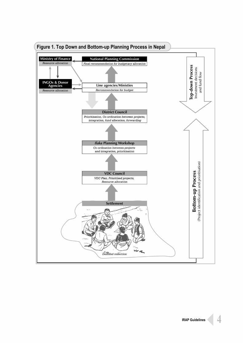
StrategicDevelopment Plan, basically defines 20-years development goals in different sectors for the district and is essentially a perspective development plan. In that sense, the Annual Plan is extracted from Periodic Plan, which in turn, is extracted from Strategic Development Plan. The practice of preparing Periodic Plans and deducing Annual Plans from it is rather a recent phenomenon in the districts. This practice has been promoted by PDDP/LGP by proposing specific steps (14 – Steps) in local-level planning and the same is adopted by Local Self-Governance Regulation, 1999. These planning steps are presented in Annex – I. Not all the districts have, as yet, gone through the Periodic as well as Strategic Planning process. Only very few districts have prepared Strategic Development Plan through the help of consultants or NGOs or donor project supports. During the periodic and annual planning cycle a bottom-up process of demand collection is usually practiced by the district authorities through series of participatory meetings organised at settlement levels. This process of demand collection culminates to Village Council for prioritisation and resource allocation then to Ilaka (comprising of number of VDCs) Workshops within the district and finally to the District Council through the District Development Committee. The District Council discusses the projects from the DDC for prioritisation, co-ordination and integration, resource allocation. This results into the District Plan. In the District Plan there are individual projects and programmes, costed and prioritised, for implementation of which budgetary allocations are either made by the DDC itself from its own sources or request for funding forwarded to government line agencies or the donor agencies. From the line ministries the Plan goes to National Planning Commission which finally makes recommendation for budgetary allocation to the Ministry of Finance for the forth-coming fiscal year. Often the request for investing on the selected projects also forwarded from line ministries or Ministry of Finance to the donor agencies. The following schematic diagram illustrates the top-down and bottom-up processes in the existing planning system.
Government machinery as part of the State Structure is organised as Sectoral line agencies from top at the centre to down at districts or VDC/ Municipalities and Wards. There are standards or policy targets for providing services, opportunities and resources to the people applicable in all the sectors. In the context of on-going decentralisation the local authorities, the DDCs and VDCs / Municipalities, have significant rights and responsibilities over development management at the local level.
4 IRAP Guidelines
Figure 1. Top Down and Bottom-up Planning Process in Nepal
5 IRAP Guidelines
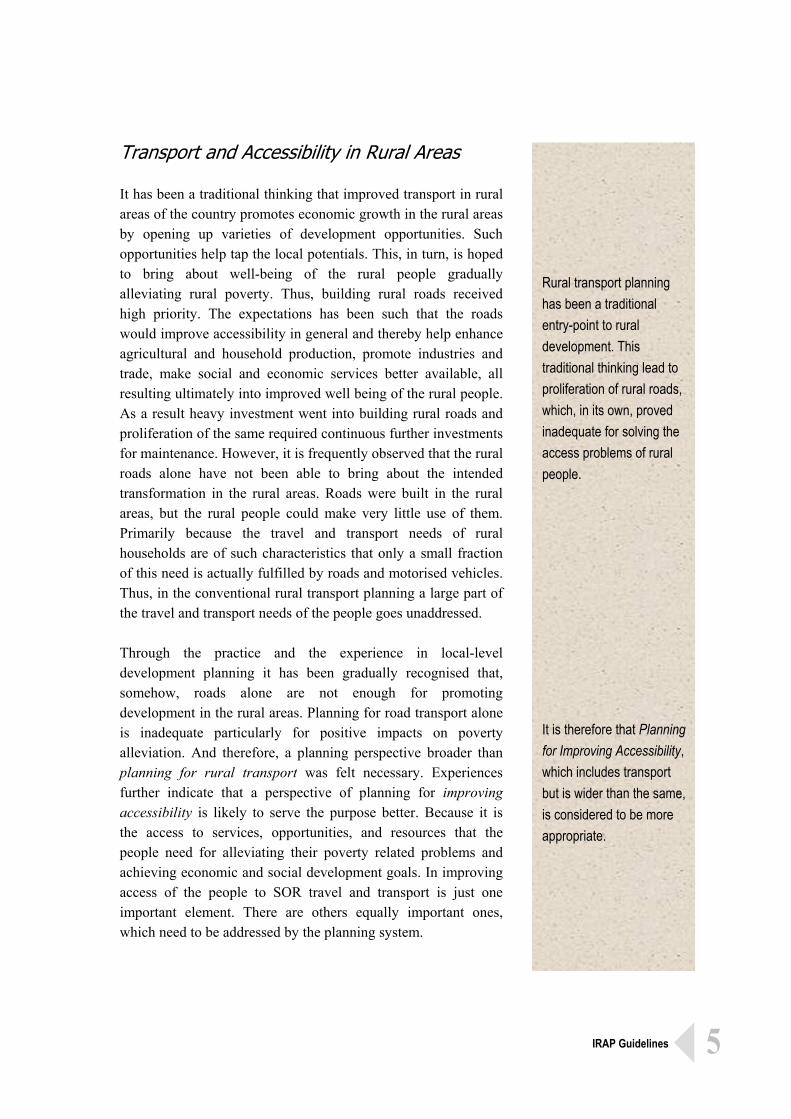
Rural transport planning has been a traditional entry-point to rural development. This traditional thinking lead to proliferation of rural roads, which, in its own, proved inadequate for solving the access problems of rural people. It is therefore that Planning for Improving Accessibility, which includes transport but is wider than the same, is considered to be more appropriate.
Transport and Accessibility in Rural Areas It has been a traditional thinking that improved transport in rural areas of the country promotes economic growth in the rural areas by opening up varieties of development opportunities. Such opportunities help tap the local potentials. This, in turn, is hoped to bring about well-being of the rural people gradually alleviating rural poverty. Thus, building rural roads received high priority. The expectations has been such that the roads would improve accessibility in general and thereby help enhance agricultural and household production, promote industries and trade, make social and economic services better available, all resulting ultimately into improved well being of the rural people. As a result heavy investment went into building rural roads and proliferation of the same required continuous further investments for maintenance. However, it is frequently observed that the rural roads alone have not been able to bring about the intended transformation in the rural areas. Roads were built in the rural areas, but the rural people could make very little use of them. Primarily because the travel and transport needs of rural households are of such characteristics that only a small fraction of this need is actually fulfilled by roads and motorised vehicles. Thus, in the conventional rural transport planning a large part of the travel and transport needs of the people goes unaddressed. Through the practice and the experience in local-level development planning it has been gradually recognised that, somehow, roads alone are not enough for promoting development in the rural areas. Planning for road transport alone is inadequate particularly for positive impacts on poverty alleviation. And therefore, a planning perspective broader than planning for rural transport was felt necessary. Experiences further indicate that a perspective of planning for improving accessibility is likely to serve the purpose better. Because it is the access to services, opportunities, and resources that the people need for alleviating their poverty related problems and achieving economic and social development goals. In improving access of the people to SOR travel and transport is just one important element. There are others equally important ones, which need to be addressed by the planning system.
6 IRAP Guidelines
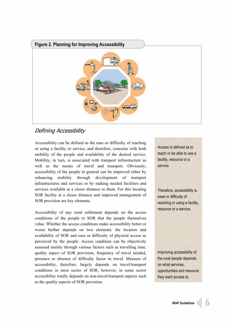
Access is defined as to reach or be able to use a facility, resource or a service. Therefore, accessibility is ease or difficulty of reaching or using a facility, resource or a service. Improving accessibility of the rural people depends on what services, opportunities and resource they want access to.
Figure 2. Planning for Improving Accessibility
Defining Accessibility Accessibility can be defined as the ease or difficulty of reaching or using a facility or service, and therefore, concerns with both mobility of the people and availability of the desired service. Mobility, in turn, is associated with transport infrastructure as well as the means of travel and transport. Obviously, accessibility of the people in general can be improved either by enhancing mobility through development of transport infrastructures and services or by making needed facilities and services available at a closer distance to them. For this locating SOR facility at a closer distance and improved management of SOR provision are key elements. Accessibility of any rural settlement depends on the access conditions of the people to SOR that the people themselves value. Whether the access conditions make accessibility better or worse further depends on two elements: the location and availability of SOR and ease or difficulty of physical access as perceived by the people. Access condition can be objectively assessed mainly through various factors such as travelling time, quality aspect of SOR provision, frequency of travel needed, presence or absence of difficulty factor in travel. Measure of accessibility, therefore, largely depends on travel/transport conditions in most sector of SOR, however, in some sector accessibility totally depends on non-travel/transport aspects such as the quality aspects of SOR provision.
7 IRAP Guidelines
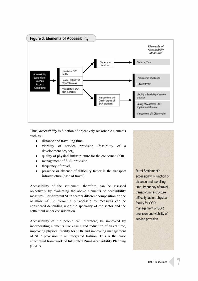
Rural Settlement’s accessibility is function of distance and travelling time, frequency of travel, transport infrastructure difficulty factor, physical facility for SOR, management of SOR provision and viability of service provision.
Figure 3. Elements of Accessibility
Thus, accessibility is function of objectively reckonable elements such as -
• distance and travelling time, • viability of service provision (feasibility of a
development project), • quality of physical infrastructure for the concerned SOR, • management of SOR provision, • frequency of travel, • presence or absence of difficulty factor in the transport
infrastructure (ease of travel). Accessibility of the settlement, therefore, can be assessed objectively by evaluating the above elements of accessibility measures. For different SOR sectors different composition of one or more of the elements of accessibility measures can be considered depending upon the speciality of the sector and the settlement under consideration. Accessibility of the people can, therefore, be improved by incorporating elements like easing and reduction of travel time, improving physical facility for SOR and improving management of SOR provision in an integrated fashion. This is the basic conceptual framework of Integrated Rural Accessibility Planning (IRAP).
8 IRAP Guidelines
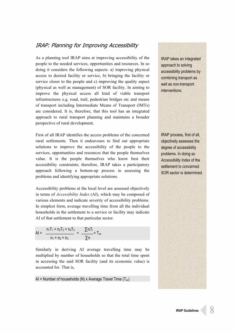
IRAP takes an integrated approach to solving accessibility problems by combining transport as well as non-transport interventions. IRAP process, first of all, objectively assesses the degree of accessibility problems. In doing so Accessibility Index of the settlement to concerned SOR sector is determined.
IRAP: Planning for Improving Accessibility As a planning tool IRAP aims at improving accessibility of the people to the needed services, opportunities and resources. In so doing it considers the following aspects: a) improving physical access to desired facility or service, b) bringing the facility or service closer to the people and c) improving the quality aspect (physical as well as management) of SOR facility. In aiming to improve the physical access all kind of viable transport infrastructures e.g. road, trail, pedestrian bridges etc and means of transport including Intermediate Means of Transport (IMTs) are considered. It is, therefore, that this tool has an integrated approach to rural transport planning and maintains a broader perspective of rural development. First of all IRAP identifies the access problems of the concerned rural settlements. Then it endeavours to find out appropriate solutions to improve the accessibility of the people to the services, opportunities and resources that the people themselves value. It is the people themselves who know best their accessibility constraints; therefore, IRAP takes a participatory approach following a bottom-up process in assessing the problems and identifying appropriate solutions. Accessibility problems at the local level are assessed objectively in terms of Accessibility Index (AI), which may be composed of various elements and indicate severity of accessibility problems. In simplest form, average travelling time from all the individual households in the settlement to a service or facility may indicate AI of that settlement to that particular sector. n1T1 + n2T2 + n3T3 ∑niTi AI = = = Tav n1 + n2 + n3 ∑n Similarly in deriving AI average travelling time may be multiplied by number of households so that the total time spent in accessing the said SOR facility (and its economic value) is accounted for. That is, AI = Number of households (N) x Average Travel Time (Tav)
9 IRAP Guidelines
AI can be used for need identification of the settlement or for project prioritisation. IRAP application process has three stages and number of steps. First stage is that of information collection and mapping; second is for analysis, intervention identification and prioritisation; third is project preparation.
Further, the quality aspects of the physical access and that of SOR facility may also be combined with travelling time in deriving AI so that actual severity of accessibility problem is reflected. Thus, AI = Tav x Df + Qa...........................................(1) AI = N (Tav) x Df + Qa.....................................(2) Where, Df = Difficulty Factor indicating the quality of transport infrastructure; and Qa = Quality aspect of SOR provision = considered in two aspects of physical
condition of the facility and management of the service provision. Application of one or the other of the above formulas depends on the circumstances. If AI is being derived for need identification of a settlement then the settlement should be considered as the basic unit of planning and Formula (1) should be applied. Whereas if AI is being derived for prioritising one or the other individual project then the total time spent needs to be accounted for and therefore Formula (2) should be applied. For simplifying the derivation of AI weighted values of the elements of accessibility measures can be taken instead of absolute values. Weighted values for these measures may be determined with reference to prevailing standards or policy targets or categorised quality levels as good, moderate and bad. Composition of one or more of these measures varies from sector to sector. IRAP: Exercise and Steps The activities to be undertaken in applying IRAP as a tool in the existing local-level planning system may be broadly put into three parts:
• Part One – T1: Information Collection and Mapping • Part Two – T2: Analysis, Intervention identification and
Prioritisation • Part Three – T3: Project Preparation
The above categories of activities are not so much discrete in themselves. There is some kind of preliminary analysis of the accessibility situation in the Part One itself, whereas, there may be need to collect further information of the concerned area in the Part Two. Similarly, some initial formulation of the projects may already take place in Part Two, whereas, Part Three deals with detailed project preparation including Implementation Plan and M&E Plan.
10 IRAP Guidelines
IRAP User's Manual (in Nepali)
In the prevailing system of development planning in the country the local authorities, DDCs in particular, have an instrumental role in local-level planning. Therefore, IRAP may be applied in district development planning process. For applying IRAP in the district planning process the following detailed steps are recommended. T1 (Information Collection) Step 1: Preparation and Defining Scope Step 2: Data and information Collection Step 3: Information Compilation and Initial Analysis Step 4: Accessibility Mapping T2 (Analysis, Intervention Identification and Prioritisation) Step 5: Analysis and Intervention Identification Step 6: Initial Project Description Step 7: Plan Integration and Documentation Step 8: District (Area) Plan T3 (Project Preparation) Step 9: Project Preparation Step 10: Implementation Plan Preparation Step 11: Monitoring and Evaluation Plan Preparation The above steps are further explained in the following chapters.
11 IRAP Guidelines
Ascertain the agency undertaking the planning exercise: Local Authority or non-local agency. Define the specific purpose of planning exercise: Strategic Plan Formulation; Periodic / Annual Plan Preparation; Community’s Need Assessment; Project Prioritisation for immediate investment; Non-local agencies should work through local authorities. Define ward or sub-ward settlements as basic unit of settlement.
Preparation and Defining Scope It is the local authorities (District Development Committees, Village Development Committees and Municipalities), which are particularly involved in local-level development planning process in Nepal. Even when non-local agencies (central or regional level project authorities), donor projects for example, are involved in making development investment the local-level planning the process usually takes place through the local authorities. In applying IRAP at the district level it is necessary to ascertain the specific purpose that it serves. It may be for formulating Strategic Plan or Periodic Plan or Annual Plan of the district. It may also be used for identifying needs of a settlement or for prioritising the projects for one-time immediate investment. First of all, this should be defined. Non-local agencies may also use IRAP for identifying and prioritising projects for the purpose of making immediate investment in a district or in an area within a district. In such contexts of local-level planning the non-local agencies are to work together with the local authorities. Any agency using IRAP for undertaking local-level planning will have to define the geographical area to be covered by the planning process. This may be delineated settlement(s), ward(s), a VDC or a group of VDCs, or the district as a whole where the planning exercise is intended. Application of IRAP has to practically focus at the settlement identifying community’s needs and prioritising projects at that level. Therefore, for each SOR sector to be addressed basic unit of settlement needs to be identified. An area of a district or a VDC may have number of individual settlements spatially spread over the area. Usually these settlements are reckonable as wards of a VDC, therefore, wards may be regarded as the individual settlements. However, sometimes the settlement pattern is such that significantly dispersed households are put under one ward and it becomes necessary to divide the ward into sub-ward settlements for
2
12 IRAP Guidelines
Identify the relevant areas to be addressed and be aware of the way these SOR sectors are organised. Gather information on sectoral standards and policy targets pertaining to nation policies as well as local priorities.
applying IRAP process. Defining the basic unit of settlement depends also on the SOR sectors being addressed. Finally, it is necessary to identify the sectoral areas to be addressed e.g. education, health, access to market, drinking water, forest resources, transport, communication, that are relevant to the area while undertaking planning exercise. In some specific cases, sometimes, sectoral area to be addressed gets already defined by the planning need. For example, if IRAP is being used for prioritising rural water supply sector projects then the sector is thus already defined as water supply. It is also necessary to have a fair understanding of how the relevant SOR sector are organised as the planning process and its outcomes needs to be being in harmony with it. If the sectoral areas to be addressed by the planning process are not already defined then the same need to be tentatively identified quite early in the process. General information about, and some primary knowledge of, the concerned area usually do indicate the relevant sectoral areas to be addressed. For making sure of the sectoral areas to be addressed there might even be a need to gather some information pertaining to the concerned area. Relevant sectoral areas to be addressed in the context of rural development usually have defined access standards or policy targets. For example, there may be a governmental policy to achieve a status of having at least primary school within, let us say, half an hour distance for all in a given time frame. This would mean a standard for access to education of one hour return trip. Similarly, a VDC may have proclaimed for making a water supply provision for the VDC inhabitants within half an hour’s return trip distance. Information on such standards or policy targets pertaining to the identified relevant sectors should be collected. In applying IRAP one should have some preliminary idea of the early stage as to what standards are to be used for different sectors. The IRAP user agency, finally, should allocate necessary resources including the planning official(s) designate (the Planner) for starting the planning process.
13 IRAP Guidelines
Collected information should facilitate understanding access needs and existing level of real access. Information from both sources, Secondary and Primary, should be collected. Secondary sources: DDC Secretariat, Government Line Agencies present in the district, Bureau of Statistics, Topographical Survey Branch, various study reports.
Data and Information Collection After having defined the scope of applying IRAP in local-level planning next activity to undertake is to collect information about the concerned area or the settlement(s). The information to be sought may comprise of demographic data of the area; various maps showing service centres or location of SOR facilities, service flow pattern, transport infrastructure inventory, resource locations; past plans and sectoral study reports. The information to be sought will have to meet the two purposes:
• to understand the general situation as to what kind of access needs (to services, opportunities and resources) the people have;
• to understand the existing level of real access that the people have to services, opportunities and resources that they value.
Secondary Source of Information There may be two sources of the information. First, the District Development Committee Secretariat itself usually has significant level of data, information and maps of the areas within the boundary of the district. Line agencies present in the district also usually have information and data relevant to the sectors of their concern. Demographic data and maps of different scales and composition are also available from Bureau of Statistics, Kathmandu and Topographical Survey Branch, Kathmandu respectively. These are secondary sources of information. Information pertaining to different standards and policy targets applicable to different relevant sectors are to be collected from different sources such as national policy documents, local policy documents, and various studies and reports. There might also be some policy targets at the local or regional or national levels. Primary Source of Information Information from the secondary sources is usually not adequate
3
14 IRAP Guidelines
IRAP Training Modules
for assessing the peoples’ access needs and the existing level of their real access. Therefore, the settlements need to be visited to obtain information from the community itself. The community people from the settlement are the best primary source of information. From the primary source the already acquired information can be verified and complemented. Additional information could also be collected as the need may be. Reliable information pertaining to average travel time, access difficulty and quality of services available can be obtained from the community people themselves. Key informants e. g. VDC officials, VDC Secretary, school teachers and community leaders can provide valuable information in this context. Particular forms or formats may be developed for collecting needful information from the concerned settlements. In case of non-existence of any standards to refer to in some sectors the local population should be consulted for their views as to learn their preferences. Such commonly accepted preferences may be regarded as the standards to be referred to for that particular sector.
Primary Sources: VDC officials, Ward officials, key informants, local teachers, community people at large.
15 IRAP Guidelines
Collected information in hardcopy or electronic version should be appropriately organised. Use of computer for information compilation helps in undertaking initial analysis. Initial analysis involves mainly with general understanding of the area and developing Accessibility Profiles and Accessibility Maps.
Information Compilation Data and information thus collected from secondary and primary sources are likely to be unorganised. They usually are in different forms and formats and in hardcopy or in electronic versions. They are to be organised in a proper structure so that preliminary accessibility situation of the settlement can be analysed. While organising the collected information the following may be kept in view:
• The demographic base data should be grouped with respect to the concerned settlement, sub-ward village, ward village, a VDC, a group of VDCs for example.
• For the physical area of consideration there should also be a base map in appropriate scale, as part of the collected information.
• The demographic data should also be grouped according to sector e. g. health, education, agricultural production etc.
• Similarly, information concerning availability of services and status of service infrastructures should be grouped according to the sector and with respect to the physical area of consideration.
• For easier analysis these data and information may also be put into computer with commonly used software like Microsoft Excel, Microsoft Word, Access, SPSS and GIS software for maps, as appropriate.
The organised information, data and maps are then to be further worked upon for making a preliminary situation analysis of the concerned area. The focus of analysis has to be on understanding as to what kind of access needs the people have and the severity of access problems that exists. Peoples’ need may be that of better access to various SOR sectors, which need to be ascertained. Similarly, there may be varying degree of severity in the access to these sectors. This also should be assessed for all the relevant sectors. This can be done by developing accessibility profiles and accessibility maps of the areas. For developing accessibility profiles the data and information are processed by calculating Accessibility Indices. Similarly, for developing Accessibility Maps various information concerning
4
16 IRAP Guidelines
accessibility situation are incorporated in the base maps. Accessibility Indicators and Profiles Accessibility depends on proximity (distance between locations) of the concerned facility, mobility aspects of the people and quality aspect of the concerned SOR provision. Measurable form of these aspects may be taken to compose Accessibility Indices (AI). AI indicates degree of severity in access problems. For proximity average travelling time may be taken as indicator. Mobility, as it depends on physical condition of the transport infrastructure and availability of transport services together with travelling time, may be reflected by difficulty factor in physical access. And quality aspect of the concerned SOR provision may be indicated by physical quality of SOR facility as well as management of service provision. Travelling time can be measured discretely whereas ease tends to be subjective and difficult to quantify. Therefore, AI of a household to concerned SOR sector can be indicated by considering magnitude of time together with quantified factor for ease or difficulty. Similarly, numerical value for physical quality of SOR facility as well as for management of service provision may be assigned. By averaging the AI of the households the settlement’s AIs can be obtained and by putting together AI of the settlement for all the concerned SOR sectors the Accessibility Profile of the settlement may be shown. Economic AIe can be obtained by multiplying AIs by the number of households in the settlement. Simply measuring absolute time for physically accessing a facility may not be much of a practical meaning to real accessibility. For example, difference between 40 minutes and 50 minutes of travel time to a school may be of no practical significance. Therefore, travel time may be considered in terms of time-slabs such as Slab 1 = up to 30 minutes, Slab 2 = 30 to 60 minutes and so forth in determining Accessibility Index for a particular service sector. For measuring the travel time for different SOR sectors different time-slabs may be appropriated
Accessibility Profile of a settlement can be developed from Accessibility Index for different sectors. Different version of Accessibility Index may be derived as per the need, such as Settlement Accessibility Index (AIs) Economic Accessibility Index (AIe) and Viability Accessibility Index (AIv).
17 IRAP Guidelines
Time may be measured in Slabs and ease or difficulty in the physical access may be considered in graded factor (Df). Similarly, the measure of quality aspect for the SOR provision may be taken as graded values for physical condition of the facility and management of service provision.
AIs = Weighted Travel Time + Weighted Quality Aspect of SOR facility = (Time In applicable Slab x Df) + Grade Physical Quality of SOR facility + Grade Management of Service and AIe = Households {Time In applicable Slab x Df) + Grade Physical Quality of SOR facility + Grade Management of Service
considering the sectoral standards, policy targets and local priorities. Similarly, the measure for quality aspect of the SOR provision may be taken as graded values for physical condition of the facility and management of service provision. The aspects of practical difficulties in the physical access like poor quality of the trail, lack of river crossing, and various kinds of associated risks can be incorporated by taking a factor, called Difficulty Factor (Df). When travelling time in Slab is multiplied by Df the resulting factor is weighted travelling time. Difficulty Factor is to be judged by the planner on the basis of compulsory consultations with the concerned people. Whether the people have good or poor access to any service depends also on the quality aspect of the concerned SOR provision. For example, if the local primary school does not have adequate number of rooms or a health post does not have medicines then access of the people to education or health services can not be good enough. Quality aspects of the SOR facility are crucial for better or poorer access; therefore, this should be somehow incorporated in the composition of AI. This can be done by taking a weighted factor for the quality aspect of the concerned SOR facility and adding the same with the weighted travel time. Weighted Quality Factor for any facility in question will have two parts: physical condition of SOR facility and management of service provision. For both of these parts grades may be assigned on the basis of the standards, policy targets and characteristics of the sector. Grades for physical quality of SOR facility and management of service provision are to be judged by the planner in compulsory consultation with the concerned people. Thus the Accessibility Index can be calculated by applying following formula:
Some times the rural peoples’ need for the better access to a service/opportunity/resource is such that the access does not really
18 IRAP Guidelines
depend on the aspects of distance and travelling. For example, providing better access to irrigation facility or to electricity does depend entirely on whether or not a project for such purpose is viable. Viability of the project may, in turn, be largely assessed from technical, economic and environmental feasibility. There are standard procedures and practices for judging technical, economic and environmental viability of individual project and from which degree of viability may be deduced as no, low, medium, high represented by numbers as 0, 1, 2, 3. In fact the degree of viability can be considered as AI for such SOR sectors indicating higher the degree of viability higher the need to intervene. AIv = degree of viability (0, 1, 2, 3) For practical purpose a table can be used in calculating Accessibility Indices for different relevant SOR sectors in any settlement as given below. Similarly, table of Accessibility Profile for an area with Accessibility Indices of many settlements for different sectors within a VDC (or an area) can be constructed. Table: Calculation of Accessibility Indices
Name of Settlement: Number of households: N
SOR Sectors
Average Travelling time ()
Difficulty Factor
Physical Quality of SOR facility Grade
Management of Services Grade
Degree of Viability
AIs AIe AIv
1 Tav Df p q v Tav x Df +p+ q N(Tav x Df +p+ q) v 2 3 4 5 …. .... ……. .... ……
Table: Accessibility Profile of a VDC (or an area) with A, B and C settlements District
VDC (or Area) Settlement /
Accessibility Index Sector
1 Sector
2 Sector
3 Sector
4 Sector
5 Sector
6 Sector
7 AIs AIe AIv
A
AIs AIe AIv
B
AIs AIe AIv
C
19 IRAP Guidelines
Provisional Accessibility Profile indicates the existing situation and needs to be transferred to base map for discussing with the community people.
Thus developed table of accessibility indices is the Provisional Accessibility Profile of that settlement and indicates accessibility situation of that settlement with respect to SOR sectors. This initial situation analysis and understanding of the area is necessary for discussing with the concerned people in identifying interventions as solutions to improve access of the people to resources, services and opportunities that they value. The average travelling time, difficulty factor in the physical access, quality aspect of the SOR facility and degree of viability do indicate to the solutions as to how accessibility can be improved. Therefore, the results of this exercise should be transferred to the base map of the area. The Provisional Accessibility Profile is to be taken to the people during participatory meetings and explain them in simple terms to receive their feedback. This can be done easily with help of maps. Once the feedbacks are incorporated the Provisional Accessibility Profile becomes the final Accessibility Profile of the concerned area.
20 IRAP Guidelines
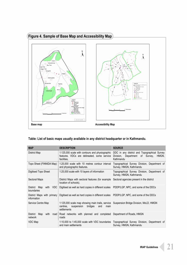
IRAP begins with base map of the settlement, either already available or to be prepared right at the outset. Computerised GIS facilities may also be used for preparing maps. Accessibility Maps show the access situation of the settlement or the households.
Accessibility Mapping Accessibility planning essentially begins with a base map of the settlement area showing the location of the households, service facilities, transport infrastructures and topographic features. If such map does not exist one should be prepared. The map should be simple showing only basic physical features, settlements, service facilities, and transport corridors. It should be of large enough scale so that community people can comprehend from a distance during discussions. Districts having GIS facility may prepare such maps with already existing information at the DDC secretariat. Otherwise base map can also be prepared by hand on the basis of already existing maps. Access information, as revealed by the Provisional Access Profile and pattern of service receivers’ flow, should be added on the base map. This can be done in different ways. One way is to draw closed line (may be a circle if applicable) around the service centre showing accessibility of the people to that service facilities. Other way is drawing radial lines of lengths proportional to Accessibility Index from the settlement to a facility for the indicated service. Thus prepared map is Initial Accessibility Map. Accessibility Map The Initial Accessibility Map are to be taken to the people of the concerned settlement during participatory meetings and discussed with them for validation, corrections, if any, and adding any new information. Thus finalised Initial Accessibility Map is the Accessibility Map of the area.
5
21 IRAP Guidelines
Figure 4. Sample of Base Map and Accessibility Map
Base map Accessibility Map
Table: List of basic maps usually available in any district headquarter or in Kathmandu. MAP DESCRIPTION SOURCE District Map 1:125,000 scale with contours and physiographic
features. VDCs are delineated, some service facilities,
DDC in any district and Topographical Survey Division, Department of Survey, HMGN, Kathmandu
Topo Sheet (FINNIDA Map) 1:25,000 scale with 10 metres contour interval and physiographic features.
Topographical Survey Division, Department of Survey, HMGN, Kathmandu
Digitised Topo Sheet 1:25,000 scale with 10 layers of information Topographical Survey Division, Department of Survey, HMGN, Kathmandu
Sectoral Maps District Maps with sectoral features (for example location of schools).
Sectoral agencies present in the district
District Map with VDC boundaries
Digitised as well as hard copies in different scales PDDP/LGP, NPC, and some of the DDCs
District Maps with primary information
Digitised as well as hard copies in different scales PDDP/LGP, NPC, and some of the DDCs
Service Centre Map 1:125,000 scale map showing main trails, service centres, suspension bridges and main settlements
Suspension Bridge Division, MoLD, HMGN
District Map with road network
Road networks with planned and completed roads
Department of Roads, HMGN
VDC Map 1:10,000 to 1:45,000 scale with VDC boundaries and main settlements
Topographical Survey Division, Department of Survey, HMGN, Kathmandu
22 IRAP Guidelines
Participatory approach is the key to bottom-up process of planning. Therefore, local peoples’ representative agencies lead the IRAP process for validation and intervention identification. For the purpose of effective participation fairly representative meetings are to be organised at the settlement level. Planner should play a role of facilitator only, detrimental views should come from the participants.
Analysis and Intervention Identification
This crucial step of IRAP requires effective participation of the local people in the planning process, therefore, involves organising participatory meeting at the settlements. This being a key element of the bottom-up planning process the village level representative institution, VDC for example, will have to take lead role in the process and the role of the planner is that of facilitator. The local people themselves analyse the access situation of their area with facilitating help of the planner and then identify the necessary intervention for improving access to different services, opportunities and resources. Validation In organising such participatory meeting the local peoples’ representative agency should take the lead role. It must be assured that the people from all the sections (strata, gender, ethnic groups, areas), officials of the local peoples’ representative institutions (wards, VDC, local NGOs, political parties, Community Groups), service provider agency and community leaders participate in the meeting. Organisation of the meeting should be such that everyone gets opportunity to express her/his opinion. First of all, the planner should present so far collected information about the settlement to the meeting. The meeting should then review the presented information about their own community and propose corrections, if necessary, and then agree upon the number of households, their access conditions to various services/opportunities/resources and average access times to different facilities. This process may lead to revision of the Initial Accessibility Indices sector by sector resulting into final Accessibility Indices. The maps may also have to be corrected then and there. This is a process of participatory analysis of the area and it validates the information collected as well as the initial accessibility analysis. The finally agreed access situation indicates to the problems or impediments to accessibility that prevails in the settlement.
6
23 IRAP Guidelines
Identification of viable interventions and their prioritisation is to be done by the community people themselves.
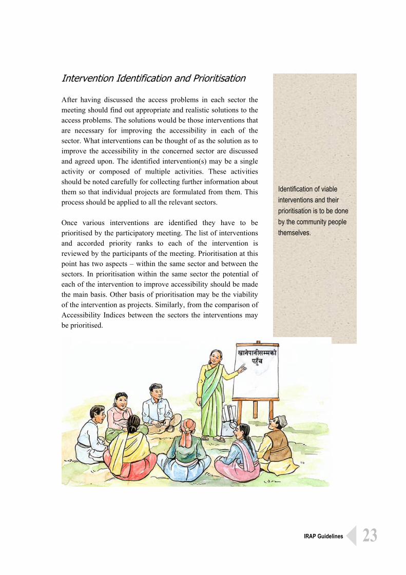
Intervention Identification and Prioritisation After having discussed the access problems in each sector the meeting should find out appropriate and realistic solutions to the access problems. The solutions would be those interventions that are necessary for improving the accessibility in each of the sector. What interventions can be thought of as the solution as to improve the accessibility in the concerned sector are discussed and agreed upon. The identified intervention(s) may be a single activity or composed of multiple activities. These activities should be noted carefully for collecting further information about them so that individual projects are formulated from them. This process should be applied to all the relevant sectors. Once various interventions are identified they have to be prioritised by the participatory meeting. The list of interventions and accorded priority ranks to each of the intervention is reviewed by the participants of the meeting. Prioritisation at this point has two aspects – within the same sector and between the sectors. In prioritisation within the same sector the potential of each of the intervention to improve accessibility should be made the main basis. Other basis of prioritisation may be the viability of the intervention as projects. Similarly, from the comparison of Accessibility Indices between the sectors the interventions may be prioritised.
24 IRAP Guidelines
Identified interventions are the viable solutions or the projects that improve accessibility of the settlement.
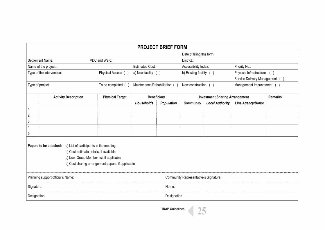
Filling of Project Brief Form is an essential part of project formulation.
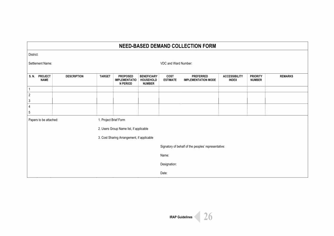
There may be number of projects from a settlement and the same need to be enlisted in the Demand Collection Form.
Initial Project Description The identified interventions are the viable solutions to improve accessibility of the people. The solution, for example may be constructing a trail, repairing a school building or arranging health personnel in an existing health post or sub-health post. For putting these solutions in place they need to be first defined as feasible projects or activities to be implemented under an investment plan. Defining the solutions as projects or activities under a development plan is Project Formulation. For formulating projects from the identified and prioritised interventions some key information like physical and budgetary size of the activity, time required for implementation, choice of technology, various resources needs will be necessary. These information pertaining to each of the identified solution would make up the project briefs. The planning official should gather these information as per the project and fill up the Project Brief Form. The information pertaining to individual projects from the Project Brief Form should be transferred to a single Demand Collection Form applicable for that settlement. For generating these project briefs support from the technical personnel from the local authority or the line agency may also be needed. Different kind of such forms are in use in the prevailing district planning practice for collecting demands of the projects from the settlements or wards. Actually, the planner should help the local people or the officials of the local peoples’ representative agency fill out this Form. This Form is owned by the local community and will have to be passed on to Village Council meeting for further discussion and budgetary allocations.
7
25 IRAP Guidelines
PROJECT BRIEF FORM
Date of filling this form: Settlement Name: VDC and Ward: District:: Name of the project:: Estimated Cost:: Accessibility Index: Priority No.:
Physical Infrastructure ( ) Type of the intervention: Physical Access ( ) a) New facility ( ) b) Existing facility ( ) Service Delivery Management ( )
Type of project: To be completed ( ) Maintenance/Rehabilitation ( ) New construction ( ) Management Improvement ( )
Beneficiary Investment Sharing Arrangement Activity Description Physical Target Households Population Community Local Authority Line Agency/Donor
Remarks
1. 2. 3. 4. 5. Papers to be attached:
a) List of participants in the meeting b) Cost-estimate details, if available c) User Group Member list, if applicable d) Cost sharing arrangement papers, if applicable
Planning support official’s Name: Community Representative’s Signature:
Signature: Name:
Designation Designation
26 IRAP Guidelines
NEED-BASED DEMAND COLLECTION FORM
District:
Settlement Name: VDC and Ward Number:
S. N. PROJECT
NAME DESCRIPTION TARGET PROPOSED
IMPLEMENTATION PERIOD
BENEFICIARY HOUSEHOLD
NUMBER
COST ESTIMATE
PREFERRED IMPLEMENTATION MODE
ACCESSIBILITY INDEX
PRIORITY NUMBER
REMARKS
1 2 3 4 5
Papers to be attached: 1. Project Brief Form
2. Users Group Name list, if applicable
3. Cost Sharing Arrangement, if applicable
Signatory of behalf of the peoples’ representative:
Name:
Designation:
Date:
27 IRAP Guidelines
Project Briefs, Demand Collection Form and the description of the process at the settlement level within a VDC gives rise to the Village Plan.
Village and District Plan: Integration and Documentation
The project briefs as resulted from the identified interventions are always related to one or the other ward or sub-ward settlement. Therefore, they are part of the development plan for the concerned settlement(s). For the VDC planning context the settlement plans need to be integrated together so as to come up with VDC plans, if the concerned settlement is not a VDC itself. Village Plan The prioritised projects from the settlements within a VDC area should be put together and the same are to be presented for discussion at the Village Council Meeting. The Village Council Meeting reviews the projects and ascertain them with VDC-level priority by comparing projects from different settlements within the Village Development Area (the area that the VDC represents). The Village Council Meeting should consider Accessibility Index as the main basis in ascertaining the level of priority to the projects from the different settlements within the Village Development Area. The Village Council Meeting may also integrate projects from adjoining settlements, if appropriate. For implementing some of the projects the Village Council may decide to allocate its own funds whereas for others it may forward to the respective line agencies or relevant non-local agency through Ilaka Workshop and district authority. The planning process and all the outputs as up to this point is to be recorded and documented. Thus developed list of projects with priority assigned to them becomes the Village Plan Document and is institutionally owned by the VDC. District Plan The approved plans from the Village Councils are to be brought together in Ilaka (group of VDCs) level planning workshop. Representatives from all the VDCs, representatives from the district line agencies, NGOs, representatives of the political parties participate in Ilaka Planning Workshops. The workshop discusses the VDC Plans for the purpose of integration, reviewing priority
8
28 IRAP Guidelines
and co-ordination between the VDC plans. The individual projects from the VDCs may be integrated as it may be appropriate, and finally refined list of projects is prepared, which then is forwarded to DDC. After having completed all the Ilaka Planning Workshops within the district the project lists from the Ilakas are presented at the District Council Meeting. The plans from the VDCs as approved from the Ilakas Planning Workshops are then to be discussed by the District Council Meeting for integration, reviewing priority, resource allocation, and co-ordination between projects. The comparison of the Accessibility Indices should be the main basis for reviewing the priorities of individual projects. For implementation of some projects the District Council makes resource allocation from its own funds whereas for others a request is forwarded to central planning agencies e.g. Line Ministries, National Planning Commission, NGOs, donor agencies. The finally approved plan from from the District Council Meeting is the District Plan. The documentation of the process and outputs starting from the Village Plans up to the conclusion of the District Council Meeting would be the District Plan Document. The Local Self-Governance Act 1999 has provided the local authorities (VDCs and the DDCs) with power and responsibility in undertaking local-level planning exercise. In the prevailing system of annual planning the Village Council Meetings are to be accomplished by the end of Mangsir (Mid December) each year. The Ilaka Workshops are to be completed by the end of Paush (Mid January) and District Council Meetings in all the districts are to be accomplished by the end of Phalgun (Mid March) each year.
Description of the process project prioritisation from VDCs to Ilaka and then to District Council and its output is District Plan.
29 IRAP Guidelines
For the implementation of the prioritised projects from the planning process the individual projects need to be prepared in detailed. Detailed preparation of the project should be undertaken in light of the governing policies and the objective of the project. Approach to implementing the project and choice of technology are fundamental to the project preparation.
Project Preparation This part of the guidelines deals with implementation of the prioritised projects resulted from the planning process. Once the decision pertaining to budgetary allocations are made it is necessary that the project(s) be prepared in detail addressing various aspects like choice of technology, the very approach of implementation, survey and design, institutional arrangement and fund-flow mechanism and monitoring and evaluation. Policies and Objectives Implementation of any development project takes place under framework of certain national or local policies, which should be identified at the very outset so that the given project is prepared making it relevant to the very policy. It is from the policy context of the project that the specific objectives of the project can be set. If the given project has not already identified the objective(s), then the same needs to be established. The objective(s) of the project in turn become guide to the project preparation throughout. It is in accordance with the project objective(s) that an approach to project implementation and choice of technology are made. Approach and Choice of Technology First of all it should be decided whether the project is to be implemented by involving the beneficiary people or in isolation. This choice depends on the project objective(s) and the nature of the specific activity within the project. If the peoples’ participation in implementation is a policy requirement then choice should be made as to what extent and in what kind of mechanism the beneficiaries are going to be involved. It could be community contracting as registered Users Group managing the project activity. It could be individuals from beneficiary families working as muster roll labours. It may be unregistered community groups working together as sub-contractors under a contracting party. Any of these approaches to peoples’ participation in implementation will involve some degree of social mobilisation.
9
30 IRAP Guidelines
Choice of technology to be adopted for implementing a project also depends largely on the project objective(s) and nature of the project. This also depends on the kind of approach to peoples’ participation adopted. One of the choices to be made usually is between labour-based technology and capital-based technology. Other important area of technology choice lies in the choice of materials, tools and equipments, and skills. Choice may also be between locally available and to be imported materials, tools and equipment and skills. Project Details: Survey and Design Often the kind of resulting projects from local-level planning are those concerning building or upgrading of local infrastructure, improving capacity (and quality) of the service facilities, capacity building of the community people. Details of the activities pertaining to these projects and ensuing costs need to be identified. If the project comprises of civil works then it should be appropriately surveyed and engineering designs be made, from which costs for all components can be estimated. Survey and design of the civil works should be kept as simple as possible depending upon the complexity and size of the project. While surveying and designing one must also consider the approach to be adopted for implementation as well as choice of technology. As most of the civil works pertaining to the local infrastructures are likely to be of simple nature the survey and design can be done by locally available technical personnel (e. g. Overseer) with use of ordinary tools like measuring tape, ranging rods, Abney level, Clinometer, Level Machine, etc.
Physical details pertaining to the project may have to be collected for preparing the project.
31 IRAP Guidelines
Implementation Plan, Institutional Arrangement, Fund-flow mechanism and M&E Plan are other important parts of the project preparation. Implementation Plan is planning of various activities with respect to time. Institutional arrangement defines the project authority, line of accountability and structure of decision making.
Implementation Plan and Monitoring and Evaluation Plan
Implementation Plan After the engineering design of the project, wherever applicable, what needs to be done as part of the project preparation is to prepare a plan of action – Implementation Plan. Implementation Plan mainly includes planning of activities with respect to time, kind of institutional arrangement and a mechanism for flow of fund. The projects are usually time-bound; therefore, the activities have to be undertaken within certain time period. The activity components are also interdependent, that is some activities can be undertaken only after certain other activities have been accomplished. This should be carefully considered in planning the activities. Availability of local peoples’ time for them to be involved in implementation process is sensitive to climatic season. Sometimes, the very nature of the activity is also season sensitive. Therefore, seasonality should be considered while planning every individual activity. Institutional Arrangement and Fund-flow Mechanism The key element of institutional arrangement is that of defining as to where the project authority lies. This is partially defined by the origin of the project itself and the source of funds for implementation. Rest should be made clear in project preparation. Various agencies may be involved in the project implementation process, the DDC, the technical agency of the government present at the district, the Users Groups, Contracting Agency, NGOs and so forth. The power and responsibility of all of these agencies must be made clear with defined lines of accountability. Proposed institutional arrangement should be such that there is a high level of transparency in the decision making process along the organisational structure of the project.
10
32 IRAP Guidelines
Fund flow mechanism largely depends on the kind of institutional arrangement made for implementation. However, there may be different options of mechanisms available for fund flow from the source to where the action is undertaken. In this it is crucial that the flow of fund should be smooth and quick involving minimum number of stop-over. This is especially important if the local community people are to be directly involved in implementation. Monitoring and Evaluation Plan A system of monitoring the project activities is necessary for maintaining a smooth implementation process as well as for ensuring the attainment of the project objectives. The process of monitoring gives feedback to the project implementation process so that necessary decisions are made and affected in time. Evaluation is to do with measuring the achievement of the targets and attainment of objectives. Evaluation may be done during the mid-way through the project implementation process or towards the completion of the project. Evaluation partially depends on the cumulative results of the monitoring. Monitoring and Evaluation Plan should be developed in consistency with the activities plan and institutional arrangement should clearly indicate monitoring and evaluating roles of different institutions involved in the implementation process. Who is involved, and in what way, in undertaking the monitoring of the project process and evaluating its achievements should be thought at the very stage of project preparation. Envisaging a well defined information flow system within the organisational framework for implementation may be very useful for putting into practice the M&E Plan.
Fund flow mechanism is an integral part of the Institutional Arrangement. An appropriate plan for monitoring and evaluation is also an important and compulsory part of the project preparation.
33 IRAP Guidelines
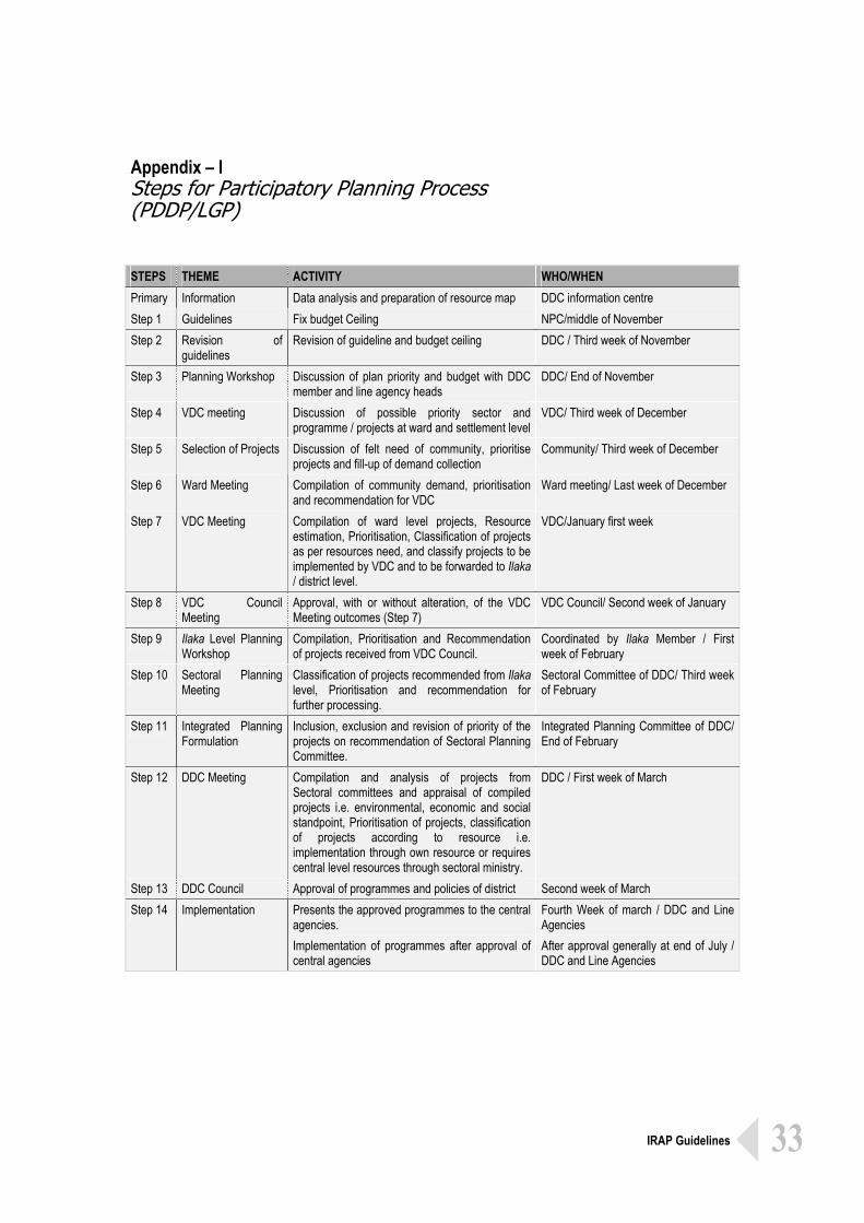
Appendix – I Steps for Participatory Planning Process (PDDP/LGP) STEPS THEME ACTIVITY WHO/WHEN Primary Information Data analysis and preparation of resource map DDC information centre Step 1 Guidelines Fix budget Ceiling NPC/middle of November Step 2 Revision of
guidelines Revision of guideline and budget ceiling DDC / Third week of November
Step 3 Planning Workshop Discussion of plan priority and budget with DDC member and line agency heads
DDC/ End of November
Step 4 VDC meeting Discussion of possible priority sector and programme / projects at ward and settlement level
VDC/ Third week of December
Step 5 Selection of Projects Discussion of felt need of community, prioritise projects and fill-up of demand collection
Community/ Third week of December
Step 6 Ward Meeting Compilation of community demand, prioritisation and recommendation for VDC
Ward meeting/ Last week of December
Step 7 VDC Meeting Compilation of ward level projects, Resource estimation, Prioritisation, Classification of projects as per resources need, and classify projects to be implemented by VDC and to be forwarded to Ilaka / district level.
VDC/January first week
Step 8 VDC Council Meeting
Approval, with or without alteration, of the VDC Meeting outcomes (Step 7)
VDC Council/ Second week of January
Step 9 Ilaka Level Planning Workshop
Compilation, Prioritisation and Recommendation of projects received from VDC Council.
Coordinated by Ilaka Member / First week of February
Step 10 Sectoral Planning Meeting
Classification of projects recommended from Ilaka level, Prioritisation and recommendation for further processing.
Sectoral Committee of DDC/ Third week of February
Step 11 Integrated Planning Formulation
Inclusion, exclusion and revision of priority of the projects on recommendation of Sectoral Planning Committee.
Integrated Planning Committee of DDC/ End of February
Step 12 DDC Meeting Compilation and analysis of projects from Sectoral committees and appraisal of compiled projects i.e. environmental, economic and social standpoint, Prioritisation of projects, classification of projects according to resource i.e. implementation through own resource or requires central level resources through sectoral ministry.
DDC / First week of March
Step 13 DDC Council Approval of programmes and policies of district Second week of March Step 14 Implementation Presents the approved programmes to the central
agencies. Implementation of programmes after approval of central agencies
Fourth Week of march / DDC and Line Agencies After approval generally at end of July / DDC and Line Agencies
34 IRAP Guidelines
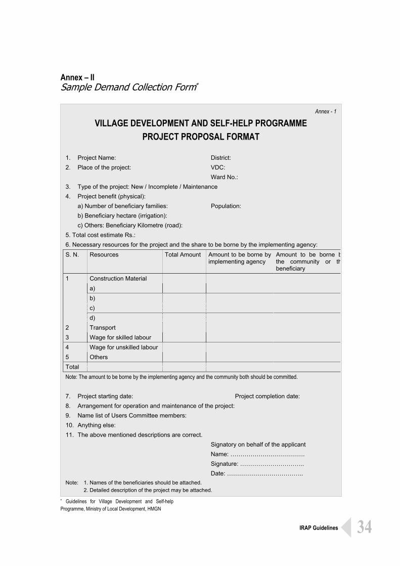
Annex – II Sample Demand Collection Form∗
∗ Guidelines for Village Development and Self-help Programme, Ministry of Local Development, HMGN
Annex - 1
VILLAGE DEVELOPMENT AND SELF-HELP PROGRAMME PROJECT PROPOSAL FORMAT
1. Project Name: District: 2. Place of the project: VDC: Ward No.: 3. Type of the project: New / Incomplete / Maintenance 4. Project benefit (physical): a) Number of beneficiary families: Population: b) Beneficiary hectare (irrigation): c) Others: Beneficiary Kilometre (road): 5. Total cost estimate Rs.: 6. Necessary resources for the project and the share to be borne by the implementing agency: S. N. Resources Total Amount Amount to be borne by
implementing agency Amount to be borne bthe community or thbeneficiary
Construction Material a) b) c)
1
d) 2 Transport 3 Wage for skilled labour 4 Wage for unskilled labour 5 Others Total Note: The amount to be borne by the implementing agency and the community both should be committed. 7. Project starting date: Project completion date: 8. Arrangement for operation and maintenance of the project: 9. Name list of Users Committee members: 10. Anything else: 11. The above mentioned descriptions are correct. Signatory on behalf of the applicant Name: ………………………………. Signature: ………………………….. Date: ……………………………….. Note: 1. Names of the beneficiaries should be attached. 2. Detailed description of the project may be attached.
Integrated Rural Accessibility Planning
Guidelines
These Guidelines are aimed at strengthening local-level
participatory planning system in Nepal by facilitating
objective assessment of access constraints of the rural
communities to needed services, opportunities and
resources. More specifically this planning tool helps
identification and prioritisation of need-based local
infrastructure projects at the local-level. These Guidelines
are based on practical experience of local-level planning and
supplement the existing planning system and are compatible
with prevailing legal and administrative system of the
country.
For further information contact: International Labour Organisation Department of Local Infrastructure Development ASIST Asia Pacific and Agricultural Roads (DoLIDAR) P. O. Box 2-349 G. P. O. Box No. 8975, EPC 797 Bangkok 10200 Kathmandu THAILAND NEPAL Email: [email protected] Email: [email protected] Website: www.iloasist.org