Embed Size (px)
Citation preview

Running head: STORMWATER MANAGEMENT 1
INTEGRATED STORMWATER MANAGEMENT AND DESIGN:
AN INFILL AND RESTORATIVE SOLUTION FOR THE COLE NOBLE DISTRICT
IN INDIANAPOLIS, INDIANA
A CREATIVE PROJECT
SUBMITTED TO THE GRADUATE SCHOOL
IN PARTIAL FULFILLMENT OF THE REQUIREMENTS
FOR THE DEGREE
MASTER OF URBAN AND REGIONAL PLANNING
BY
CLAIRE E. BOWERS
ADVISOR: BRUCE RACE
COLLEGE OF ARCHITECTURE AND PLANNING
BALL STATE UNIVERSITY
MUNCIE, INDIANA
MAY 2013
Stormwater Management 2
ACKNOWLEDGEMENTS First, I would like to extend sincere gratitude to my advisor, Professor Bruce Race for
inspiring me to reach for academic goals I deemed unreachable. His proficiency and
guidance has facilitated the steady progression of this project. I am grateful for help
structuring this project, as provided by an admirable teacher of English, Professor
Geralyn Strecker. Thank you to Christine Rhine for her patience and prompt efforts. The
professors in the department of Urban and Regional Planning have instilled in me a zeal
for learning about this field. My fellow classmates contributed friendly criticism and
advice for which I am thankful. I am indebted to my parents for supplying everlasting
support and encouragement throughout my academic journey. At the core of my
perseverance is my mom, and her infinite capacity to love. I am grateful also to my sister
and closest friends, whose curiosity and continuous optimism motivated my work. Last
but not least, I would like to render my appreciation to Rohan for his fervent enthusiasm
in my goals, aspiring outlook, and loyal disposition.

Stormwater Management 3
ABSTRACT CREATIVE PROJECT: Integrated Stormwater Management and Design: An Infill and Restorative Solution for the Cole Noble District in Indianapolis, Indiana STUDENT: Claire E. Bowers DEGREE: Master of Urban and Regional Planning COLLEGE: Architecture and Planning DATE: May 2013 PAGES: 81 Green infrastructure has emerged as a viable solution for addressing stormwater
issues in urban areas. However, municipalities have voiced concern regarding the costs of
implementing green infrastructure and ensuring a beneficial outcome. This creative
project explores a range of green infrastructure strategies and the potential to integrate
practices with broader urban design goals for the Cole Noble mixed-use district in the
city of Indianapolis.
The project is informed by a review of literature and three case studies. The
review of sources provides analysis of conventional stormwater management systems,
stormwater retrofit design strategies, and partnership acquisition to advance innovative
stormwater management techniques. An analysis of three Midwestern cities facing issues
of combined sewer overflows informs the methodology for selecting particular green
infrastructure practices and integrating urban design concepts.

Stormwater Management 4
This creative project demonstrates the practicality of implementing a network of
green infrastructure practices in urban redevelopments. Utilizing green infrastructure
practices, the project enhances the public realm and thereby attains broader design goals
and environmental objectives within the Cole Noble District. By integrating green
infrastructure into district redevelopment, the creative project illustrates the design plus
environmental benefits of investing in stormwater management policies and standards.

Stormwater Management 5
TABLE OF CONTENTS ACKNOWLEDGEMENTS ........................................................................................... 2 ABSTRACT ..................................................................................................................... 3 TABLE OF CONTENTS ............................................................................................... 5 LIST OF FIGURES ........................................................................................................ 7 1.0 Project Framework .................................................................................................. 9
1.1 Introduction .......................................................................................................... 9
1.2 Research Aims ..................................................................................................... 10
1.3 Research Questions .............................................................................................. 10
1.4 Research Methods ................................................................................................ 11
2.0 Literature Review ..................................................................................................... 12
2.1 Introduction ........................................................................................................... 12
2.2 Urban Design Influences on Stormwater Management ........................................ 12
2.3 Stormwater Retrofit Design Strategies ................................................................ 20
2.4 Public and Private Sector Approaches to Stormwater Management ................... 30
3.0 Case Studies ............................................................................................................... 38
3.1 Introduction .......................................................................................................... 38
3.2 Cincinnati, Ohio ................................................................................................... 39
3.3 Nashville, Tennessee ............................................................................................ 42
3.4 Kansas City, Missouri .......................................................................................... 46
3.5 Summary .............................................................................................................. 49
4.0 Creative Project Description ................................................................................... 52
4.1 Project Description ............................................................................................... 52
4.2 Project Context ...................................................................................................... 52
4.3 Scoping and Analysis ............................................................................................ 54
4.4 Urban Design Considerations and Challenges ...................................................... 58
4.5 Goals and Objectives ............................................................................................ 59

Stormwater Management 6
4.6 Opportunity Site Identification ............................................................................ 59
4.7 Building Typologies .............................................................................................. 61
4.8 Street Typologies .................................................................................................. 62
4.9 Block Typologies .................................................................................................. 63
4.10 Development Program ........................................................................................ 64
5.0 Summary and Implementation ............................................................................... 66
5.1 Selection of Green Infrastructure Practices .......................................................... 66
5.2 Block-level Implementation ................................................................................. 71
5.3 Project Summary ................................................................................................... 72
5.4 Future Research .................................................................................................... 73
BIBLIOGRAPHY .......................................................................................................... 75

Stormwater Management 7
LIST OF FIGURES
Figure 1: Formula for Water Quality Volume (WQv) .................................................................. 15
Figure 2: Correlation Between Land Use and Impervious Surface Coverage ............................. 16
Figure 3: Stormwater Sizing Criteria ............................................................................................ 17
Figure 4: Effectives of Stormwater Retrofit Strategies Implemented Over Time ........................ 25
Figure 5: Context Map ................................................................................................................. 53
Figure 6: Annual Rainfall Data for Indianapolis .......................................................................... 56
Figure 7: Existing Site Imperviousness in the Cole Noble District ............................................. 56
Figure 8: Existing Land Uses ....................................................................................................... 57
Figure 9: Existing Building Types ............................................................................................... 57
Figure 10: Circulation Analysis ................................................................................................... 58
Figure 11: Gateways Assessment ................................................................................................. 60
Figure 12: Opportunity Sites and Surface Water Flow ................................................................. 60
Figure 13: Connections and Proposed Destinations ..................................................................... 61
Figure 14: Proposed Street Hierarchy Building Types ................................................................ 62
Figure 15: Mixed-use Residential Block, Cultural Courtyard Core ............................................ 63
Figure 16: Mixed-use Commercial Block, Eatery and Entertainment Hub .................................. 64
Figure 17: Union Plaza Block ....................................................................................................... 64
Figure 18: Residential and Mixed-use Residential Block, Cultural Courtyard Core ................... 64
Figure 19: Proposed Land Use Plan ............................................................................................. 65
Figure 20: Development Program ................................................................................................. 65

Stormwater Management 8
Figure 21: Urban Design and Green Infrastructure Plan ............................................................. 68
Figure 22: Pervious Pavers ........................................................................................................... 68
Figure 23: Pervious Gutter ............................................................................................................ 69
Figure 24: Pervious Pavement ...................................................................................................... 69
Figure 25: Tree Box Planter .......................................................................................................... 69
Figure 26: Rain Garden ................................................................................................................. 70
Figure 27: Cistern ........................................................................................................................ 70
Figure 28: Extensive Green Roof ................................................................................................ 70
Stormwater Management 9
1.0 Project Framework 1.1 Introduction The foundation for this creative project is based on a pre-determined research
procedure used to guide the overall direction of inquiry and ensure the consistency
among sources reviewed and studied. A literature review was initiated by setting research
aims, which refer to general project goals. The aims are expressed as short action-
oriented statements of intent for conducting the research, which led to specific research
questions. The aims delineate valuable topics, and the coinciding questions narrow the
focus of research to gain a clear understanding of stormwater management. The research
questions served as the selection criteria for literature sources as well as the underlying
guide for collecting information. The following subsections list the research aims and
sequential questions applied in the literature review.
The literature review provided a broad understanding of quantitative factors for
analysis, retrofit design strategies, and integrative approaches to stormwater management
practices. The case study linkages provided the ability to conceptualize and hypothesize a
successful network of green infrastructure practices. The creative project description
section explains the process of developing the design concept and identifies essential
components for testing the hypotheses. The final summary and implementation section
takes a detailed look at the integration of green infrastructure practices and urban design
principles at the block-level.

Stormwater Management 10
1.2 Research Aims
The aims set broad perimeters for the research. Each aim contemplates potential
quantitative theories associated with stormwater management. The aims are geared
towards research regarding tools for selecting, organizing, and maintaining practices in
urban stormwater management systems at the local level.
Aim 1: Define selection criteria for green infrastructure strategies
Aim 2: Understand stormwater best-management-practice (BMP) strategies
Aim 3: Review public-private implementation approach to BMPs
1.3 Research Questions
The questions define key reference points for the research. Each question is still
general enough to ensure that the research will yield a number of viable sources. The
selection of literature is premised on the research questions, which help decipher the
pertinent information in each source and develop a consistent understanding among
sources.
Question 1: How does stormwater sizing criteria influence the selection of
management practices?
Question 2: How do municipalities determine an appropriate mix of design
strategies to apply in retrofits to existing stormwater management systems?
Question 3: How do municipalities integrate the roles of public and private
entities to promote, maintain, and monitor best management practices?

Stormwater Management 11
1.4 Research Methods
The process of gaining information and knowledge essential to the development
of this creative project included the reviewing various literature sources and three case
studies. The method to the literature review verifies the credibility of research presented
in this document. The consistency of the method is evident in the set of questions
developed for the literature review. At least five sources were considered for each
research question. The types of sources selected for each question included professional
and academic journals, municipal standards and best practice guidelines, and interviews
of practitioners.
The literature review and general exploratory reading informed the case study
method and scope of research. The method to the three case studies is also based on a set
of “how” and “why” questions. The questions are drawn from research aims plus physical
units of analysis. Pre-determined physical units of analysis included combined sewer
systems, Midwest locations, urban settings, green infrastructure, and partnership
acquisition. These were used as selection criteria for cases. The questions are integral to
the selection of cases and collection of information. Selecting three case studies
facilitated the ability to detect patterns and draw logistical comparisons. Similarities and
differences were evaluated for the three case studies, as described in section three of this
document.

Stormwater Management 12
2.0 Literature Review The literature review is structured by a set of questions established to guide the
research. A minimum of five sources for each question was selected. General descriptions
of each question help categorize research findings, Urban Design Influences on
Stormwater Management, Stormwater Retrofit Design Strategies, and Public and Private
Sector Approaches to Stormwater Management
2.1 Introduction
The research questions directed the selection of literature sources, and
subsequently guided the collection of information. Using the interrogative adverb “how,”
each question provoked a quantitative idea. The review of literature presented
information previously unknown and aided in the understanding of stormwater
management systems and related concepts. Selected sources also presented lesser-known
topics correlated to stormwater management, suggesting future research.
2.2 Urban Design Influences on Stormwater Management
When a watershed is subject to high levels of urban development, its native
hydrologic functions become vulnerable to levels of degradation. Urbanization can lead
to unforeseen problems within a water system that are hard to remedy, especially when

Stormwater Management 13
there is insufficient understanding or lack of concern for the cause and effect of
development activities. The intensity of runoff is a direct outcome of land output. As the
demand for certain land uses increases in an urbanizing area, trees are cleared and lots are
paved, increasing the amount of runoff. The quality of hydrology systems is also
impacted as pollutant loads intensify from expansive impermeable surfaces. In response
to urban runoff issues, municipalities build storm sewers, gutters and other flow-through
structures to transfer runoff to downstream channels. In ultra urban areas, rainfall events
augment subsurface stormwater runoff, which ultimately jeopardizes the performance of
stream channels. As the volume of runoff increases, the channel flow becomes more
rapid, increasing the likelihood of pollutant discharge. Rather than going straight to the
cause of watershed dilapidation, channels are expanded and excavated to handle more
substantial runoff episodes.
Authors Derek B. Booth and Rhett C. Jackson (1997) propose two responses in
regards to stormwater runoff and design issues. The first concerns policy, and regulating
design performance of retention and detention facilities for managing stormwater.
Retention facilities, such as ponds, are used to collect and store stormwater runoff until it
is released through infiltration. Detention facilities serve the purpose of decelerating the
rate of subsurface runoff. Performance criteria could include instituting peak duration
standards for retention and detention facilities. Peak standards address objectives to
“maintain post-development peak discharges at their pre-development levels” and
duration standards address objectives to “maintain the post-development duration of all
sediment transporting discharges at pre-development levels” (Booth & Jackson, 1997, p.
8).

Stormwater Management 14
Assessing levels at which sediment discharge begins to disrupt a water channel is
necessary to determine design guidelines. Thresholds can be interpreted as design
standards; however, thresholds can vary based on receiving water channels so site-by-site
analysis is recommended. Analysis is the second method recommended for confronting
design issues. Based on the analysis findings for a site, alternative models can be
designed for detention and retention facilities. This allows design comparison among the
land uses within an urban watershed.
Regulation at the watershed level may involve performance thresholds to ensure
developers do not surpass a site’s designated runoff levels. In urban areas, design
limitations exist due to prevailing changes made to the natural landscape and hydrologic
system.
This increases the costs of facilities necessary to help reverse the damage. Booth
and Jackson conclude the article titled, Urbanization of Aquatic Systems: Degradation
Thresholds, Stormwater Detection, and the Limits of Mitigation (1997), by propositioning
that true water protection is not possible without a better understanding of land
development processes in relation to water pollution and conveyance.
The New York State Stormwater Management Design Manual (2010), describes
the connection between sizing criteria and stormwater management practices while
emphasizing the important role certain criterion play in the design process and
achievement of goals. The point of relevancy in the manual to this creative project is the
methodology used to calculate the water quality volume (WQv) for a site in accordance
with designated sizing criteria.

Stormwater Management 15
The Center for Watershed Protection (2010) explains, “the water quality volume is
designed to improve water quality sizing to capture and treat 90% of the average annual
stormwater runoff volume” (p. 57). The percentage rate represents a target objective and
is subject to change based on the average amount of precipitation that is accumulated on
a site from a rainfall event. The amount of impervious surface coverage on a site directly
influences the volume of runoff, which ultimately affects the water quality storage
volume. Figure 2.01 presents the equation used to determine the water quality storage
volume of a site. The numeric value that results after performing the equation with the
necessary sizing criterion is the amount of space available on a site for storing stormwater
runoff. When designing for water quality, the Center for Watershed Protection (2010)
offers numeric assumptions that can be applied in cases of site inaccessibility. When
calculating the impervious cover on a site, all surfaces must be accounted for including,
“paved and gravel road surfaces, paved and gravel parking lots, paved driveways,
building structures, paved sidewalks, and miscellaneous impermeable structures such as
patios, pools, and sheds” (Center for Watershed Protection, 2010, p. 58). Figure 2.02
outlines land use types and the average measurements that can be applied to each.
Figure 1 Formula for Water Quality Volume (WQv)
Source: Center for Watershed Protection, 2010, p. 57

Stormwater Management 16
Figure 2 Land Use and Imperviousness
Source: Center for Watershed Protection, 2010
The Maryland Stormwater Management Program: A new Approach to
Stormwater Design (2003) written by Stewart R. Comstock and Charles Wallis, suggests
a different approach to stormwater management that emphasizes integrating management
practices with “total site design” (p.1). Customary stormwater management designs have
focused on structural practices to control runoff after development took place. Authors
Comstock and Wallis recommend refocusing stormwater design to convey “avoidance,
minimization, and mitigation” as a part of comprehensive site design to mitigate
environmentally detrimental development and promote the use of sustainable
development techniques (p. 9). It is suggested that stormwater management should be
regarded as a fundamental component of every site design in order to successfully protect
water resources and reduce harmful impacts of runoff.

Stormwater Management 17
To ensure the protection of water resources in Maryland, design criteria was
established as described in The Maryland Stormwater Management Program: A new
Approach to Stormwater Design (2003). Impervious surface coverage directly influences
the volume of stormwater runoff accumulated on a site. Three of the five criteria address
runoff volume: water quality, recharge, and channel protection. The criterion most
applicable to this project is water quality volume (WQv). Authors Comstock and Wallis
(2003) provide the formula for assessing a site’s WQv, as well as the formulas for the
remaining criteria (Figure 2.03). Expansive storage opportunities exist on sites that have
large portions of impervious surfaces. Calculating WQv gives designers the ability to
determine the amount of storage necessary to treat and manage stormwater runoff on a
particular site. This criterion also aids in selecting the most appropriate best management
practices for a site.
Figure 3 Stormwater Sizing Criteria
Source: Comstock & Wallis, 2003, p. 4
According to the National Risk Management Research Laboratory (2002), when
considering best management practices, designers should have a clear understanding of
Stormwater Management 18
watershed goals, as well as any federal, state, and local regulations concerning
stormwater runoff and pollution. Conventional stormwater management practices and
sewer systems have been constructed to control floods. Focus on minimizing flooding in
relation to natural aquatic functions resulted in state and local mandates precisely related
to peak stormwater discharges. Initiatives have since been made in response to urban
stormwater runoff and the associated impacts on water quality.
Select best management practices have been redesigned to treat polluted runoff
and address issues of water quality, not just quantity. Municipalities are also beginning to
look at the potential for using best management practices as a means of collecting water
for non-consumptive reuses. It is implied in Considerations in the Design of Treatment
Best Management Practices (BMPs) to Improve Water Quality (2002) that designing best
management practices for treating stormwater runoff in addition to controlling floods has
been progressing in both larger and smaller-scale watersheds.
In the articled titled, Is Denser Greener? An Evaluation of Higher Density
Development as an Urban Stormwater-Quality Best Management Practice (2009) authors
John S. Jacob and Ricardo Lopez propose that the superlative management practice for
protecting water quality is not among those classified best management practices.
Through a study looking at high-density developments in comparison to average scale
suburban developments, authors John S. Jacob and Ricardo Lopez (2009) hypothesize
that grouping development in one area and sequentially increasing the density will
decrease the demand for impervious surfaces and ultimately reduce the risk of harming
water resources (Jacob & Lopez, 2009, p. 2).

Stormwater Management 19
Pavement causes changes in the course and magnitude of stormwater runoff. Considering
density as a best management practice is presented as a question of whether or not having
a greater amount of smaller open spaces and higher, clustered developments will result in
a substantial reduction in the amount of polluted runoff.
Measures of density include gross density and net density. Net density accounts
for residential units only and is most commonly denoted as DUA, which means dwelling
units per acre. Gross density takes into account the total area of land when measuring
population density (Jacob & Lopez, 2009, p. 3). Results of the study indicate that the mix
of land uses in an area is a key component for reducing pollutant loads in stormwater
runoff through higher-density and clustered development.
At what point higher density actually results in a load reduction will depend on
the specific event mean concentration values (EMC) and impervious fractions used”
(Jacob & Lopez, 2009, p. 8). The term event mean concentration values (EMC) refers to
the mix of common pollutants in runoff generated from certain land uses. Promoting
higher urban density as a best management practice for conserving natural land and
improving water quality may be difficult in communities as the human population
continues to grow. However, higher-density and clustered development may be
considered effective for addressing concurrent issues in an urban community including
vehicle dependence and harmful polluted stormwater runoff.
Stormwater Management 20
2.3 Stormwater Retrofit Design Strategies
Author Richard A. Claytor, Jr. offers a series of steps essential for implementing
successful stormwater retrofit projects in An Eight-Step Approach to Stormwater
Retrofitting: How to Get Them Implemented (2009). Urban environments that lack any
previous control measures for stormwater runoff are ideal for retrofits, which are a
measure of structural best management practices. Stormwater retrofits are often
combined with other watershed strategies intended to restore aspects of an urban
landscape prior to development. Ensuring the restorative capabilities of a retrofit practice
in ultra urban settings can be challenging due to pollutant loads and lack of sufficient
capture and storage areas.
According to Claytor, Jr. (2009), it is beneficial to apply stormwater retrofit
projects in addition to other restoration strategies for watershed improvement.
Restoration strategies focus on improving the native hydrology of streams, rivers, and
lakes within a watershed. Approaching watershed restoration from a more holistic
perspective requires watershed managers to consider stormwater retrofitting.
The author elaborates on an eight-step process for implementing stormwater
retrofit projects in an urban watershed context. The first step is designated as the
watershed retrofit inventory, as this is often the initial step when developing a traditional
stormwater management program. This step is important because it is beneficial to first
identify sites that offer flexible access points and or water features. Sites that are located
within a short distance to existing stormwater management facilities are also considered
to be prime candidates for retrofit practices.

Stormwater Management 21
A stormwater management facility refers to a single control technique used to achieve a
specific goal, or set of goals. Stormwater management is an inclusive term used to
describe all of the techniques used to achieve goals, which might include, to reduce
pollutants, retain the rate of stormwater runoff, decrease the risk of combined sewer
overflow events, and simulate the flow of water prior to impacts of urbanization (Claytor,
Jr., 2009, p. 2).
Step two requires further assessment of the candidate sites identified in step one.
Mapping key design features such as drainage and outfall locations is vital to determining
whether or not a site suitable for retrofit practices. The third step entails determining a
strategy for implementation based on prearranged objectives. Retrofit strategies focus on
achieving one or more comprehensive objectives set within a watershed but vary in
regards to areas of focus.
The author suggests that developing retrofit criteria is practical for assessing the
feasibility of a site. Claytor, Jr. (2009) argues that specific criterion worthy of
consideration is, “pollutant removal capability, stream channel protection capability, cost
of facility, ability to implement the project, and potential for public benefit” (Claytor, Jr.,
2009, p. 4). Informing the public about a retrofit project is an important step to
implementation. The fourth step involves gaining support from property owners and local
residents by encouraging public participation in the planning and designing of retrofit
projects.
The fifth step, and most relevant step to this review, is designing the retrofit
project. It is during this step that stormwater retrofit facilities are selected by working in
reverse order compared to the traditional BMP design process.

Stormwater Management 22
Designers of retrofit projects must first take into account the existing conditions, whereas
designers of traditional stormwater projects must first understand stipulated design
criteria. Pre-existing conditions of a site, especially sites in urban and ultra urban
contexts, can present a retrofit designer with stringent limitations, resulting in few
obtainable stormwater facilities to select from. Retrofit projects must be designed with a
broader context in mind due to the amount of existing infrastructure, utilities,
environmentally sensitive areas, and private properties that often surround candidate
sites. Finding a design equilibrium that takes full advantage of retrofit opportunities while
minimizing adverse impacts to surrounding land uses is crucial to retrofit success
(Claytor, Jr., 2009, p. 5).
Step six of the implementation process is permitting, which helps to ensure that a
retrofit project is designed to have the least significant impacts on any environmentally
sensitive or protected areas and maximizes public benefit. Stormwater storage constraints
make it difficult for retrofit designers to guarantee minimal impact to adjacent properties
and or infrastructure during construction, especially in highly developed areas (Claytor,
Jr., 2009, p. 5). The seventh step implicates construction inspections, which guide the
execution of a retrofit project. Stormwater retrofit facilities are designed differently than
conventional stormwater practices, so it is important that designers offer direction to
contractors throughout the course of construction (Claytor, Jr., 2009, p. 5). The retrofit
implementation process concludes with deciding on an appropriate maintenance program
for the long-term success of stormwater facilities. Maintenance requirements for retrofit
projects that are implemented in urban and ultra urban environments may more stringent
due to high traffic and increased risk for pollutant loads from various activities.

Stormwater Management 23
The Urban Stormwater Retrofit Practices (2007) manual is the third in a series of
Urban Subwatershed Restoration Manuals. The third manual was prepared by Tom
Schueler, David Hirschman, Michael Novotney, and Jennifer Zielinski whom introduce
stormwater retrofits as a means of refurbishing watersheds by providing treatment to
areas that have had no previous stormwater management practices implemented, or the
practices were deemed unsuccessful. The authors focus on stormwater retrofits in sub-
watershed contexts throughout the manual. It is clearly defined that restoration objectives
are different than overall sub-watershed objectives.
These objectives delineate the reasons for using retrofits rather than new
stormwater practices and concern explicit issues in a sub-watershed. Retrofit practices
tend to be installed on public land, as retrofits can be costly and proposing
implementation on public land presents the opportunity to receive funding (Schueler,
Hirschman, Novotney, & Zielinski, 2007, p. 34). It is important for retrofit teams to
recognize the correlation between rainfall and runoff in a sub-watershed. The distribution
of stormwater plays a strategic role in determining target runoff volumes for retrofit
projects. The rainfall frequency spectrum is proposed as a tool that can be used when
setting targets for achieving restoration objectives. It is suggested that the most common
objectives for retrofitting are managing runoff for recharge, improving water quality and
improving stream channel flow, all of which target smaller rainfall events (Schueler et al.,
2007, p. 17). One potential impediment to retrofit projects is obtaining enough storage
capacity to effectively manage stormwater runoff targets, which is why it is important for
retrofit teams to establish a “sizing criteria” in relation to restoration objectives (Schueler
et al., 2007, p. 17).
Stormwater Management 24
Storage retrofits and on-site retrofits are considered to be two approaches for
maximizing treatment and storage capacities in a sub-watershed area. Storage retrofits
work best in locations that offer substantial space for larger volumes of runoff. Sizeable
amounts of land in urban areas that are often necessary for storage retrofits are typically
publicly owned. Storage retrofits can be implemented in existing ponds, public right-of-
ways, below storm drain outfalls, road embankments, parks, and floodplains.
On-site retrofits are used for treating and mitigating stormwater runoff generated by
impervious surface coverage. Locations in ultra urban areas are ideal for on-site retrofits
as there is often not enough space required for implementing storage retrofits and a lot of
impervious sites. On-site retrofits are commonly implemented on privately owned land
including locations such as smaller parking lots, streets, roofs, plazas, and underground
(Schueler et al., 2007, p. 25).
The manual explores eight options that can be used in retrofitting as a means for
effectively treating stormwater runoff. The eight options described in the manual include
the following, extended detention, wet ponds, constructed wetlands, bio-retention,
filtering practices, infiltration practices, swales, and a range of on-site practices focused
on reducing runoff from rooftops. Schueler et al. (2007) explained on page 29 that on-site
practices consist of, “rain gardens, rain barrels, green roofs, cisterns stormwater planters,
dry wells, or permeable pavers.” Following the eight treatment options, an eight-step
process is recommended to guide stormwater retrofitting.

Stormwater Management 25
The retrofit process consists of the following steps beginning with the first and ending
with the last, retrofit scoping, desktop retrofit analysis, retrofit reconnaissance
investigation, compile retrofit inventory, evaluation and ranking, sub-watershed treatment
analysis, final design and construction, and inspection and maintenance (Schueler et al.,
2007, p. 204).
When designing retrofit projects, it is suggested that cost-effectiveness should be
the primary driver for achieving objectives. On-site retrofits tend to be the more
expensive approach in comparison to storage retrofits, so storage retrofits are endorsed as
the primary retrofit approach that designers should consider. The first chapter of the
manual ends with a detailed description of methods that can be employed to help ensure
the installation of retrofits over time. The following figure shows the correlation between
retrofit strategies, time of implementation, and effectiveness over a thirty-year time
period.
Figure 4 Effectives of Stormwater Retrofit Strategies Implemented Over Time
Source: Schueler, Hirschman, Novotney, & Zielinski, 2007, p. 35

The article titled, Watershed Retrofit and Management Evaluation for Urban
Stormwater Management Systems in North Carolina chronicles the study of an urban
watershed located in Durham, North Carolina known as New Hope Creek watershed. The
objective for conducting the study as noted by authors, Kathy DeBusk, William F. Hunt,
Upton Hatch, and Olha Sydorovych (2010) was to, “evaluate the feasibility of alternative
approaches to stormwater management for existing developments” (p. 64). An inventory
of existing land uses allowed Debusk et al. to estimate the pollutant loadings and amount
of stormwater runoff being generated by existing development within the New Hope
Creek watershed. Nine retrofit best management practices (BMP) were recognized as
appropriate BMP types for achieving watershed-wide objectives.
The results of the inventory showed that the most common land use type was
impervious parking lots, which led the authors to delineate permeable pavement as the
most favored retrofit BMP among the other types. The other potential retrofit BMPs
included, bio-retention, green roofs, water harvesting systems, proprietary devices,
stormwater wetlands, sand filters, underground detention, and vegetated swales (DeBusk
et al., 2010, p. 65). Various locations were analyzed using a set of criteria for determining
feasible sites for implementing permeable pavement. Specific criterion included
maximum slope, presumed parking lot use, and maintenance requirements. By relying on
this set of criteria, the most opportune site locations were quickly identified.
DeBusk et al. (2010) also analyzed land use types within New Hope watershed
boundaries to determine where the greatest amount of retrofit opportunities existed.

Stormwater Management 27
Findings of the study support that institutional and commercial land uses plus parking
lots offer the greatest retrofit potential, whereas roadways and industrial land uses offer
the least retrofit potential. According to DeBusk et al. (2010), “roadways in urban areas
offer many constraints, including lack of space, the presence of utilities and sanitary
sewers, and high traffic volumes” (p. 70). The study of the New Hope Creek watershed
described in this article indicates the critical role land uses play when stormwater retrofit
projects are designed.
Research by Tony H. F. Wong and Malcolm L. Eadie (2000) resulted in findings
that development growth and rapid urbanization have contributed to intensified rates and
volumes of stormwater runoff. The article titled, Water Sensitive Urban Design – A
Paradigm Shift in Urban Design (2000) poses the need to transform the way stormwater
management is initiated in urban areas. Based on the widespread nature of runoff
impacts, stormwater management should be at the forefront of comprehensive planning
and design. In the past, stormwater runoff has been addressed as an issue of quantity.
More recently, stormwater managers are confronting the issue of water quality as well.
Wong and Eadie (2000) suggest stormwater management in urban landscapes will call for
“a range of measures that can appear to be mutually exclusive” (p. 3). Water Sensitive
Urban Design is introduced as an approach to the process of planning and designing
stormwater management systems in urban areas (Wong & Eadie, 2000, p. 3). In order to
successfully address the multiple issues typically associated with stormwater runoff,
stormwater managers may consider integrating objectives with a range of urban planning
and design projects.
Stormwater Management 28
There is no single stormwater control measure that can be applied in response to
numerous issues. However, selecting a variety of control measures to collectively address
multiples objectives is viable. The authors present hypothetical stormwater management
objectives and the different structural control measures that might be considered when
designing a management system intended to achieve each objective. Stormwater
management objectives include, “stormwater drainage, stormwater as a resource,
protection of receiving water quality, and protection of downstream aquatic habitats”
(Wong & Eadie, 2000, p. 3).
When striving to achieve objectives concerning water quality, many of the
appropriate control measures for doing so also address objectives concerning stormwater
quantity. It is common for urban areas to have existing stormwater control measures
designed to manage stormwater quantity. As stormwater managers become increasingly
aware of the importance of protecting water quality in urban settings, the notion of
retrofitting existing control measures to involve water quality treatment methods becomes
more intriguing.
Stormwater management methods that are characteristic of densely developed
areas reflect short-term solutions to rapid runoff issues (Wong & Eadie, 2000, p. 6).
Retrofitting existing stormwater measures on a specific site might include the addition of
treatment techniques deemed suitable with existing methods and conditions. Retrofit
opportunities encourage the systematic integration of existing site design and appropriate
stormwater control measures so that multiple objectives, including those focused on
quality and quantity, are more likely to be achieved as part of a broader plan.

Stormwater Management 29
Authors William D. Shuster, Matthew A. Morrison, and Rachel Webb suggest
that the widespread, centralized approach to stormwater management initially formed out
of reactions to increased flooding and wastewater management issues in urban areas.
Conventional systems designed for managing stormwater runoff include combined
sewers for both wastewater and stormwater, and separate storm sewers, which the author
implies is a better system but still ineffective at mitigating adverse impacts of runoff
when major rainfall events take place.
The introduction imparts that Shuster, Morrison, and Webb (2008), are opposed to
the “centralized approach” to stormwater management (p. 3). Shuster, Morrison, and
Webb (2008) emphasize that “the limitations of centralized management become a
rationale for retrofitting existing infrastructure and decentralization of stormwater
management” (as cited in Hammer, 1972; Klein, 1979). The text further supports that the
decentralized approach is increasing in popularity among municipalities as more are
experiencing first-hand the drawbacks of a centralized approach.
The decentralized approach embraces both structural and non-structural source
controls for managing stormwater runoff. These controls are characteristically associated
with Low-impact development (LID), which is said to promote objectives in line with
restoration goals formed at comprehensive watershed scales (Shuster et al., 2008, p. 3).
One major goal of low impact development is to emulate the functions of water prior to
the urbanization of native landscapes. Low impact development employs a mixture of
techniques and site-specific designs for addressing environmental objectives identified by
smaller scale developments.
Stormwater Management 30
The decentralized stormwater management approach expands upon the notion of
LID by relating those smaller scale techniques and design methods to larger scale
objectives within urban watersheds. Shuster, Morrison, and Webb argue that retrofit
management is the action of implementing LID principles in existing urban settings.
Applying LID practices with the intent of efficiently managing stormwater runoff
requires commitment from citizens, non-governmental organizations, developers, and
agencies from all levels of government (Shuster et al., 2008 p. 14). The decentralized
management approach provides role flexibility while fostering long-term stability in
regards to planning and designing LID practices for addressing
stormwater issues in existing urban areas. 2.4 Public and Private Sector Approaches to Stormwater Management
In the article Local Institutional Development and Organizational Change for
Advancing Sustainable Urban Water Futures (2008), Rebekah R. Brown introduces the
term “sustainable urban water management” as a different and more unified approach to
traditional urban water management practices (p. 1). She suggests that the philosophy
behind sustainable urban water management is administering practices that consider
water as a holistic system. Brown (2008) considers possible hindrances to implementing
practices similar to sustainable urban water management, as well as potential reasons for
the lack of accepting communities.
According to Brown (2008), a particular strategy referred to as “institutional
capacity building” can be beneficial to bureaucracies interested in advancing principles of
sustainable urban water management.

Stormwater Management 31
This strategy delineates three tools for building capacity in an organization: human
resource development, intra and inter-organizational strengthening, and institutional
reform (Brown, 2008, p. 11). Among the three tools, the intra and inter-organizational
strengthening was described as being the action most likely to initiate collaboration
between public and private entities. The process of organizational reform entails moving
from conventional management practices to sustainable urban water management at the
local government level. The process is arranged as a series of phases: “project, outsider,
growth, insider, and integrated” (Brown, 2008, p. 12). She suggests that the growth
phase is the primary indicator of whether or not a local government has any inclination
to institute sustainable urban water management practices. It is emphasized that during
the growth phase ambiguity of department roles and responsibilities exists, which could
be a factor of deterrence.
Notable organizational change occurs during the insider phase, as the author
mentions that departments such as the planning, environment, and engineering
departments initiate working on projects together. Roles among departments become
more defined within the organization during this phase and as a result, insider expertise is
established. Organizational features representative of sustainable urban water
management are typically first recognized during the integrated phase of organizational
reform. During the integrated phase, sustainable practices become fundamental principles
of bureaucratic programs. Brown (2008) states that local government organizations that
have experienced changes typical of the integrated phase view “their role as providing
strong community governance and informed local leadership” (p. 9).

Stormwater Management 32
The phases of organizational reform are summarized at the end of the article to
reiterate the purported effectiveness of the process for “urban water strategists, policy
makers, and decision makers” striving to initiate sustainable urban water management
practices (Brown, 2008, p. 12). The article points to capacity building as a pivotal
element for progressing sustainable urban water management practices in government
organizations that denote strong political profiles.
The article titled, Stakeholder Preferences for Best Management Practices for
Non-Point Source Pollution and Stormwater Control was written by Michael D.
Kaplowitz and Frank Lupi in 2011. The article explains research conducted by Kaplowitz
and Lupi (2011) to understand the public’s role in successful stormwater management
programs. (Kaplowitz & Lupi, 2011) distinguish two main categories of best
management practices (BMPs), structural and non-structural. Kaplowitz and Lupi (2011)
identify “watershed stakeholders, managers, and decision makers” (p. 2) as local figures
responsible for selecting non-structural and structural stormwater management practices.
Implementing non-structural BMPs entails advocating for water quality by enforcing
local policy and or holding public, educational sessions. Structural BMPs involve
building and assembling practices for controlling and reducing stormwater runoff.
Research by Kaplowitz and Lupi (2011) supports that landowners and residents
do have concerns regarding the selection of best management practices. Kaplowitz and
Lupi (2011) created and distributed choice experiment surveys to local stakeholders in
the Sycamore Creek watershed located in Michigan. The first survey provided
respondents with written descriptions of various BMP’s and potential “trade-offs” (p. 4)
associated with each practice (Kaplowitz & Lupi, 2011).

Stormwater Management 33
The second survey provided respondents with graphic descriptions of BMP’s through
photographs and design details. Each survey asked respondents to select a preferable mix
of practices based on the preceding assessment. Results showed “no significant
substantive differences in the responses to the two versions of the survey” (Kaplowitz &
Lupi, 2011, p. 4); however responses from the first survey were further analyzed to
understand the public’s desires for BMPs. The survey helped to realize the public’s
perception of different BMPs selected for managing stormwater. The research conducted
by Kaplowitz & Lupi (2011), as described in the article supports that most communities
would benefit from involving the public in selecting best management practices.
Green City, Clean Waters is a plan based on the Philadelphia Water Department’s
(PWD) long-term vision to assimilate goals, control measures, and management
approaches among a range of city projects and plans to ultimately address combined
sewer overflow issues. The Philadelphia Water Department (2009), conveys that
achieving watershed goals is contingent on forming partnerships with stakeholders at a
regional level, and redefining conventional roles of agencies at a local level. The plan
addresses the process and practices necessary to ensure the longevity and vitality of
watersheds in the region. It also expands upon environmental protection and measures of
sustainability in the city.
The 25-year plan identifies the need to integrate selected practices for managing
combined sewer overflows with other regional goals to ensure maximum benefits are
achieved at reasonable costs (Philadelphia Water Department, 2009). The PWD’s initial
objective for the plan involved categorizing links among broad environmental and social
issues to create opportunities for agencies to collaboratively address a range of issues.

Stormwater Management 34
The water department took on an expanded role in local government by advocating for
goal integration. This encouraged other agencies to consider sustainable approaches to
achieving citywide goals.
The integrated approach taken by the PWD ultimately led to an inclusive, long-
term vision for the city, known as the Green City, Clean Waters plan. Green City, Clean
Waters illuminates green infrastructure practices for managing stormwater runoff.
Inspection teams delegated by the PWD maintain constructed green infrastructure
practices. The Philadelphia Water Department (2009) states quantitative factors
considered when selecting green infrastructure practices, which include projected “water
quality and ecosystem improvement, improved recreation access and appearance,
reduction in heat stress mortality, improved air quality, energy savings, and increased
property values” (p. 506). Qualitative factors of consideration include “public support,
construction and operation feasibility, reliability and past performance of technology,
complexity and difficulty of solution, and coordination and consistency with other PWD
and city programs” (Philadelphia Water Department, 2009, p. 508).
Non-profit watershed organizations have formed on a partnership basis with the
Philadelphia water department to provide informative resources and technical assistance
to the public. A partnership agreement was established between the U.S. Environmental
Protection Agency (EPA) and the City of Philadelphia in support of the Green City,
Clean Waters program and progressing green infrastructure practices in the city (City of
Philadelphia; U.S. Environmental Protection Agency, 2012). The agreement confirms
supportive actions by the EPA as agencies collaboratively work towards achieving water
quality and stormwater pollution goals.
Stormwater Management 35
The city of Philadelphia and the EPA work to set forth collaborative projects that aid in
the advancement of green infrastructure and encourage local businesses and members of
the community to participate in the process.
The South Florida Water Management District (2002), prepared an educational
document for the public to explain urban stormwater runoff and management practices
for addressing stormwater issues. The technical publication titled, Best Management
Practices for South Florida Urban Stormwater Management Systems, emphasizes public
support as a key component to successful best management practices (BMPs). Structural
BMPs can demand altering the pre-existing design fabric of a site. Certain structural
BMP projects are subject to a landowner’s willingness to accept or oppose the necessary
land construction. Non-structural BMPs involve the use of policy to enforce regulations
and/or mandates. When selecting non-structural BMPs, The Water Management District
implies that policy makers should consider “conservation, recycling, and source controls;
maintenance and operational procedures; and educational and outreach programs” (South
Florida Water Management District, 2002, p. 22).
Facilitating regulatory programs requires local governments are required to
comply with federal, state, local and site specific regulations. It is suggested that “public
education is a BMP that can be implemented to meet the individual needs and interests of
each segment of a community” (South Florida Water Management District, 2002, p. 26).
Acknowledging the public’s preferences could help stimulate interest and support for a
range of government projects and plans.

Stormwater Management 36
The South Florida Water Management District (2002) describes interactive and
informative tools for increasing local awareness of stormwater runoff issues in a
community, encouraging participation, and promoting individual best practices.
The article titled, Choosing the Right Watershed Management Structure was
published in a compilation of articles by the Center for Watershed Protection (2000). It is
suggested that to ensure stable watershed development over time, an assessment of viable
management structures would be worthwhile. The writer implies that organization(s)
should first clarify any long-term partnerships and/or inter-agency agreements that are
pertinent to the longevity of a management structure. Three models demonstrating
different organizational structures are posed as viable options a watershed manager might
chose from. Strong delineations can be made among the three structures looking at the in
charge. The first model depicts a government-directed management approach, the second
model a citizen-directed approach, and the third model a hybrid approach (“Management
Structure,” 2000). The first model places a local or regional government agency in
charge, whereas the second model is nonhierarchical and managed by a group of citizens.
The hybrid model merges select organizational components from the government-
directed model and the citizen-directed model.
Theories concerning disadvantages and advantages of each management structure
are presented in the article, as well as effectual political and societal realms for success.
Findings support that the hybrid structure is the most flexible among the three when it
comes to ideal watershed organizations (“Management Structure,” 2000).

Stormwater Management 37
It is proposed that incorporating a technical advisory committee and/or citizen advisory
committee to a watershed management structure may be beneficial to the long-term
stability of watershed plans. Research proves that facilitating a co-operative working
relationship between government agencies and stakeholders in a hybrid management
structure can be challenging. However, “memorandums of understanding” can be used to
define the terms of partnerships formed amongst government agencies, private entities,
and public organizations (“Management Structure,” 2000).
Stormwater Management 38
3.0 Case Studies This section explores three parallel cases that pertain to stormwater issues and
combined sewer overflows. Each case exemplifies the use of green infrastructure to
reduce stormwater runoff and alleviate sewage and stormwater loads on combined sewer
systems. The three case studies are organized by a set of pertinent questions. Different
green infrastructure approaches are depicted in each case, however each community has
similar factors of success and/or limitation to green infrastructure practices.
3.1 Introduction
The following case studies examine three Midwest communities served by
combined sewer systems. Each case illustrates the use of green infrastructure practices to
control combined sewer overflows caused by high volumes of stormwater runoff.
Overflow is a combination of sewage and stormwater, which is released from sewers
once maximum capacity is reached. All of the communities have existing urban design
patterns. Each community needs to meet federal and/or state requirements. Hundreds of
communities in the United States are facing similar issues of combined sewer overflow
and stormwater runoff. These case studies consider potential approaches to designing and
developing effective control plans for existing built environments.

Stormwater Management 39
3.2 Cincinnati, Ohio
Overview
Cincinnati is among hundreds of cities in the United States with a combined
sewer system (CSS), which convey both sewage and stormwater through the same pipes.
According to the Lick Run Watershed Master Plan (2012) Cincinnati’s stormwater sewer
pipes were first constructed in the 19th century, and then sanitary sewer lines were
connected to the stormwater pipes. Heavy rainfall events increase the risk of sewage
overflows due to the overwhelming amount of stormwater and sewage in the sewer
system. In response to overflows, outlets along the sewers were created to release excess
water to local waterways. This common approach to dealing with overflows has resulted
in many communities struggling with issues of water quality and pollution.
In response to a federal consent order, the Metropolitan Sewer District of Greater
Cincinnati (MSD) has initiated watershed-based projects to address the city’s combined
sewer overflow (CSO) problem. Through Project Groundwork, a regional public works
project, MSD is required to meet CSO reduction mandates. Project Groundwork includes
improvements to existing sewers and various stormwater control projects (Metropolitan
Sewer District of Greater Cincinnati, 2012, p. 18).
Cincinnati is located in Hamilton County, which spans five watersheds in
southwestern Ohio. Among the five, the Lick Run watershed releases the highest annual
volume of combined sewer overflows into the Mill Creek waterway.
Stormwater Management 40
Over time, urbanization has led to an increase in the number of combined sewer
overflows. During an overflow event, billions of gallons of raw sewage and stormwater
flood into waterways and at times into residents’ basements. As stated in the Master Plan,
Cincinnati receives an annual rainfall of 41 inches, and an estimated 1.5 billion gallons of
raw sewage and stormwater overflow from the Lick Run watershed. Discharged into Mill
Creek, the excess water is mainly comprised of stormwater, with less than 25% being
sewage (Metropolitan Sewer District of Greater Cincinnati, 2012, p. 24).
MSD describes three approaches to solving combined sewer issues caused by
heavy precipitation. The first approach is source control, which suggests installing
control methods to prevent or hinder stormwater from reaching combined sewers.
Conveyance and storage is the second approach, building larger conveyance sewers
and/or underground storage tunnels for excess stormwater and sewage. The third
approach considers modernizing wastewater treatment plants to accommodate CSO
before transferring the overflow into a waterway (Metropolitan Sewer District of Greater
Cincinnati, 2012).
Published in May 2012, The Lick Run Watershed Master Plan chronicles the approach
taken by the Metropolitan Sewer District of Greater Cincinnati, bureaucratic agencies,
and local organizations for addressing combined sewer overflows and water quality
issues. In 2011, the Metropolitan Sewer District of Greater Cincinnati (MSD) began
partnering with local public agencies to combine goals and design objectives for the Lick
Run watershed with other planning projects in the watershed area and Cincinnati. To
understand existing watershed conditions and assess potential CSO reduction solutions,

MSD integrated input from property owners, public agencies, other stakeholders, plus the
design team.
The first step in the Lick Run watershed planning process was a community
design workshop. After determining visual preferences from members of the community,
the design team was able to establish a set of design objectives that would help guide the
selection of reduction solutions. The next step identified design challenges by exploring
existing conditions of combined sewer pipes, underground utilities, roadways, traffic,
businesses, and buildings. Watershed-specific conditions allowed MSD to narrow the
number of potential reduction solutions to focus on those that could be integrated with the
community’s broader goals and objectives. The third step was separating the urban
waterway planning area into three zones, which were then evaluated to determine specific
design concepts that best complemented local visual preferences and watershed goals.
Analyzing the walkability of important corridors plus existing building uses and
viable opportunity sites was integral to determining urban design concepts that enhanced
the existing urban fabric while reducing CSO. Planning for green infrastructure at the
watershed scale may involve establishing a set of guiding principles based on site-
specific analysis, technical evaluations, collaborative efforts, and community input. This
was the case for the Lick Run watershed project, which led to the development of the
integrated network of CSO reduction solutions (Metropolitan Sewer District of Greater
Cincinnati, 2012).
The Metropolitan Sewer District of Greater Cincinnati (MSD) founded the
Communities of the Future initiative in 2011 to employ the public to gather information
regarding community aspirations and opportunities.

Stormwater Management 42
Forming partnerships was also important to the MSD to ensure potential CSO
reduction projects would maximize public benefits and leverage costs. The MSD engaged
the public by hosting various events, including open houses, meetings, tours, and
workshops. Postcards were mailed to businesses, property owners, residents, and other
stakeholders to publicize community meetings and workshops. Workshop
announcements were published in local newsletters on online to encourage the public to
attend. Workshops addressed other topics of concerns in the watershed to stimulate the
formation of an integrated plan. Promoting innovative green infrastructure projects that
manage stormwater runoff and enhance the connectivity plus visual appearance of a
space spurs partnership development.
3.3 Nashville, Tennessee
Overview
In 2009, the city of Nashville, Tennessee, developed a master plan to implement
Green Infrastructure for a local Stormwater Master Planning District, which had been
established that year by a local ordinance, stating that the district would share the same
boundaries as those defined for the combined sewer system (CSS) area. The four
metropolitan government agencies responsible for helping to establish the Green
Infrastructure Master Plan included Metro Water Services (MSS), the Metropolitan
Planning Department, the Metropolitan Development and Housing Agency, and the
Department of Public Works (Metropolitan Sewer District of Greater Cincinnati, 2012).
Nearby non-profit organizations also took part in the planning process.

Stormwater Management 43
Requirements of the plan included the identifying potential project sites and
opportunities plus selecting and designing green infrastructure practices. Green
Infrastructure refers to stormwater management practices built to coexist with native
ecosystems. Rather than addressing stormwater issues through traditional methods such
as structural underground pipes, green infrastructure focuses on recreating the pre-
existing hydrologic functions of an urban space at the ground level (Metropolitan Sewer
District of Greater Cincinnati, 2012)
Green Infrastructure practices are designed with environmental conditions in
mind. This environmental approach to stormwater site design was analyzed for a specific
district located in Nashville, Tennessee. The combined sewer system (CSS) area that
comprises the district was separated into ten sub-basins to better analyze the different
land uses and site-specific characteristics. Of the district’s 7,878 acres of land, an
estimated 45.6% was impervious. Parking lots in the area totaled 1,175 acres, equating to
a ratio of 1:10 for impervious to pervious surface area. The characteristics of existing
buildings in the CSS area included hundreds of structures with barren, flat roofs. The
estimated tree canopy cover of the area was 19.5%, indicating the opportunity to plant
trees for detaining rainfall and reducing runoff volume (Metro Water Services, 2009, p.
12).
Each of the four agencies designated roles in the Green Infrastructure Master Plan
development process. Through collaboration, a set of design objectives was established,
and six priority project sites were declared in 2010.
Stormwater Management 44
The set of design objectives was based on maximizing the role of Green Infrastructure to
improve existing facilities, stimulate job growth, and preserve native ecosystems and
aquatic functions (Metro Water Services, 2009, p. 23). The Green Infrastructure Master
Plan chronicles the approach used to assess potential Green Infrastructure practices.
The first step analyzed twelve common practices, illuminated as possible
stormwater controls to reduce the amount of runoff and peak flow rate plus improve and
maintain water quality. Practices evaluated in the Metropolitan Government of Nashville
and Davidson County Green Infrastructure Master plan (2009) included downspout
disconnection, filter strips, infiltration practices, pocket wetlands, permeable pavement,
rain barrels/cisterns, rain gardens/bioretention, soil amendments, street trees and
afforestation, tree box filters, vegetated roofs, and vegetated swales. All of the preceding
practices may be implemented on individual sites as part of a broader plan. The same set
of stormwater management objectives was used to evaluate the effectiveness of each
practice. The ability to design practices that could be integrated with the existing urban
fabric was a fundamental consideration during the selection process. Other considerations
included site suitability, performance limitations, deterrents to installation, and land area
demand (Metro Water Services, 2009).
The subsequent step involved a technical analysis of implementing Green
Infrastructure practices in the ten sub-basins that constitute the combined sewer system
area. Characteristics of a site that may play a role in the selection of Green Infrastructure
practices include impervious surface coverage, soil typologies, rainfall, and runoff
distribution.
Stormwater Management 45
Potential factors of constraint include the scale of existing building(s), timing, impacts,
and uncertainty of political, physical and cultural factors (Metro Water Services, 2009).
The Metro Nashville Green Infrastructure Plan demonstrates using a set of criteria to help
evaluate the effectiveness of various practices (Metro Water Services, 2009, p. 24).
For the case of Metro Nashville’s Green Infrastructure Master Plan, the favorable
selection and design of practices was contingent upon the collaboration of multiple
departments at the metropolitan government level. The planning process was initiated by
Metro Water Services (MSS), the Metropolitan Planning Department, the Metropolitan
Development and Housing Agency, and the Department of Public Works through each
department’s identification of problematic sites and opportunities within CSS boundaries.
Suitable locations for pilot projects included properties owned by the government.
Components that help promote implementation include defining the goal(s) of a Green
Infrastructure project, presenting conceptual designs, and estimating installation costs
plus the amount of runoff reduction.
Retrofitting existing development is becoming increasingly popular in urban
communities struggling with stormwater runoff issues. In Metro Nashville, the Green
Infrastructure Master Plan addressed using incentives for encouraging Green
Infrastructure as a means of retrofitting (Metro Water Services, 2009, p. 14). Five
incentive-based approaches were ultimately selected to promote Green Infrastructure
practices in new development and retrofit development. Redevelopment projects offer
partnership opportunities for implementing practices. As result of the Green
Infrastructure Master Plan, Nashville has initiated programs with similar intent.

Stormwater Management 46
3.4 Kansas City, Missouri
Overview
Kansas City’s sanitary sewer system was constructed in the 19th century.
Accounting for 58 square miles of the entire sanitary sewer system, combined sewers
conveying both sewage and stormwater were built in areas of the city that today are
considered historic. Outside of this area, the sanitary sewer performs as a separate
system. Within the 58-square-mile radius, the original combined sewers no longer have
the capacity to handle higher volumes of stormwater runoff. When a population grows,
sewers are impacted with larger quantities of sewage. Besides population growth,
increased commercial and office development has led to greater portions of land with
impervious surface coverage. As a result, moderate rainfall events generate larger
quantities of stormwater runoff. In the case of Kansas City’s combined sewer system,
overflow episodes are a direct consequence of stormwater runoff.
At the time the Overflow Control Plan was written in 2009, the Kansas City
Water Services Department had a National Pollutant Discharge Elimination System
(NPDES) permit issued by the Missouri Department of Natural Resources (MDNR) (City
of Kansas City, 2009). This permit authorizes a municipality to discharge an amount of
combined sewer overflows. Typically, separate sewer systems are designed to avoid
overflow episodes with the exception of substantial storms. Due to the age of the existing
sanitary sewer infrastructure, the separate sewer system in Kansas City could no longer
perform to MDNR standards. Overflow episodes were occurring outside the combined
sewer system, which were not admissible under a NPDES permit.

Stormwater Management 47
In response to overflow issues, the city developed an Overflow Control Plan and
stormwater initiatives (City of Kansas City, 2009).
The Kansas City Overflow Control Plan (2009) is the result of a five-year
planning process, which started in 2003 after the establishment of the Wet Weather
Community Panel (City of Kansas City, 2009, p. 8). The appointed group members
employed “systems thinking” throughout the planning process to promote an all-inclusive
approach to understanding and solving the overflow issue (City of Kansas City, 2009, p.
9). Potential design solutions were founded on the city’s triple bottom line model, which
incorporated people, prosperity, and the planet (City of Kansas City, 2009, p. 8). The
collaborative design process involved stakeholders and professionals from a range of
disciplinary fields. Ensuring a holistic analysis of the planning area required engaging the
community in the planning process.
The Wet Weather Community Panel emphasized adaptive management as the
basis for the Overflow Control Plan. This approach to management recognizes the need
to continuously refine and enhance project designs, management strategies, and
performance indicators as changes in the environment, economy, and society occur.
Three activities were recognized as opportunities to apply principles of adaptive
management: restoring the existing sewer infrastructure, employing methods to mitigate
stormwater inflow to the system, and analyzing potential sites for implementing green
infrastructure practices.
Kansas City’s combined sewer system serves seven basins that encompass 58
square miles (City of Kansas City, 2009, p. 17). The Blue River is the eastern boundary
of the area, and the Missouri River is the northern boundary.

Stormwater Management 48
Each of the seven basins contributes to overflow episodes, which on average occur at
least 18 times per year. Among the seven basins, the Middle Blue River Basin was
selected as the location for the City’s first Green Infrastructure pilot project. Known as
the Marlborough Green Infrastructure project, it was intended to demonstrate how
surface-level green infrastructure practices could be implemented to store stormwater and
control combined sewer overflows. The specific project site consisted of 100 acres in a
neighborhood designated for residential and commercial business use (City of Kansas
City, 2009, p. 18).
Green infrastructure practices considered for the Marlborough pilot project were
contingent on objectives other than controlling overflows and reducing discharged
pollutants. Factors included whether a practice would improve community interaction,
provide partnership opportunities, and/or offer maximum benefit to residents and
businesses. Implementing practices in areas with a mixture of land uses was also
important to measure effectiveness and assess maintenance methods plus variable costs
(City of Kansas City, 2009).
The Overflow Control Plan was developed to direct citywide efforts to reduce
combined sewer overflows caused by storm events. The plan proposes wet weather
solutions based on requirements set forth by federal and state agencies plus a set of
localized objectives. Establishing strong public and private partnerships is key to ensure
future generations enjoy maximum benefits resulting from the plan. Kansas city
identified neighborhood associations as viable candidates for a partnership. Educational
programs that encourage public participation in the planning and design process for
larger-scale projects can influence individual efforts to reduce stormwater runoff.

Stormwater Management 49
In Kansas City, implementing green infrastructure pilot projects focused on large-
scale sites and widespread locations. Government institutions often fund pilot projects
based on the higher probability to benefit economic development in a community.
Larger-scale pilot projects showcase innovative practices to a mass of people.
Demonstrating potential outcomes of different green infrastructure practices can
influence private businesses and organizations to invest in future projects. Integrating
planned overflow solutions with other compatible projects can increase value and reduce
implementation costs. The Kansas City Overflow Control Plan suggests combining CSO
plans with other related projects through interagency cooperation (City of Kansas City,
2009).
3.5 Summary of Case Studies
The plans studied in each of the preceding cases propose projects that offer
solutions to community-wide problems caused by combined sewer overflows (CSO). All
three communities illustrate innovative approaches to developing plans and design
solutions for overflow issues in existing urban areas. Green infrastructure practices were
pivotal elements of each plan, although the context in for proposed solutions varied. The
three plans prioritized integrating stormwater management projects with interrelated
programs to maximize social, economic, and environmental benefits, local needs, desires,
and preferences influenced the selection and design of potential green infrastructure
practices.

Stormwater Management 50
Each project considered public participation and input as invaluable to its
progression. Policy recognition was integral for determining an initial planning approach
and framework. Analysis was performed through different methods, although each
community relied on technical findings to help evaluate alternative green infrastructure
practices. Each plan identified strategies for initiating public and private partnerships to
advance project implementation. Partnerships increase opportunities for investment and
promote goal stability. The degree of collaboration between local agencies and
organizations throughout the planning process can influence the project’s long-term
success.
An interview conducted with an anonymous Federal research scientist working in
Cleveland, Ohio provided insight concerning partnerships as a tool for promoting green
infrastructure in communities. Each community is different in terms of cultural, political,
social, climatic, and topographic conditions, which ultimately translates into a different
mix of appropriate green infrastructure practices for a site. The scale and context of a
potential project site correlates with the potential to form local partnerships. According to
the anonymous Federal research scientist, community development corporations (CDC)
are “instrumental in keeping research moving. In Cleveland, we think of the CDC as a
‘bridging organization’ that is essential to fomenting communication and offering
leadership to keep a project going” (personal communication, February 27th, 2013).
Project goals are often wide-ranging and can be incorporated into a
comprehensive plan. Two of the three plans provided detailed recommendations for long-
term implementation of green infrastructure projects and the ongoing success of
stormwater management programs.

Stormwater Management 51
Each community recognized the need for measuring project performance and maintaining
their effectiveness over a period of time. Non-regulatory and regulatory tools may be
used at various planning levels to ensure the green infrastructure practices continue to
hold value and effectiveness over time.
Combined sewer overflow control plans typically involve planning for
revitalizing and enhancing existing built environments. Many green infrastructure
practices provide the ability to gradually assimilate stormwater management systems into
the existing design fabric. Anticipating the likelihood of political, social, and economic
obstacles, adaptive planning approaches are advantageous for addressing overflow issues
in an urban community. A balance of non-regulatory design objectives and management
policies for green infrastructure systems will advance stormwater management plans in
communities.

Stormwater Management 52
4.0 Creative Project Description 4.1 Project Description
The Noble Green creative project proposes redeveloping Cole Noble, an evolving
urban mixed-use district in Indianapolis. The process is explored in detail to provide logic
for each step, including project context and design framework, scoping and analysis,
goals and objectives, and opportunity site identification. Stormwater management
concepts studied in the literature review inform the site-specific analysis and key design
considerations and principles. Goals and objectives were established based on technical
content and existing city policy. The methodology used to select site-appropriate green
infrastructure practices was derived from case study findings. The project description
explains the process and steps leading up to the application of green infrastructure
practices in the Cole Noble District, as explained in the Summary and Implementation
section.

Stormwater Management 53
4.2 Project Context
The Cole Noble District is approximately 76.5 acres and is located directly east of
Monument Circle in Indianapolis. Miami Street forms the northern border, and
Washington Street forms the southern border. The eastern border is Interstate 65, and the
western border is Alabama Street, which the Cultural Trail runs adjacent to. A railroad
passes diagonally through the southeast quadrant of the district. A creek known as
Pogue’s Run flows parallel to the railroad. An exit ramp from I-65 intersects with Ohio
Street, running east to west, which has subsequently led to the foundation of a highly
vehicle-oriented arterial. Market Street is also a major east-west arterial providing civic
views of Monument Circle. The cultural and historic character of Washington Street
has been ignored throughout periods of urban redevelopment within the district. The pre-
existing urban fabric is comprised of the following land uses: mid-density mixed-use,
office, commercial, public special use, parking lots, multi-family residential, light
industrial, and vacant. The design framework considers the surrounding land uses, which
include single-family residential, office, mid to high-density mixed-use, and commercial.
Lockerbie Square is a historic, single-family residential neighborhood located directly
north of the Cole Noble district. The number of parking lots in the district has led to a
pandemic of impervious surface coverage and underutilized space.

Stormwater Management 54
Noble Green is a proposed stormwater retrofit infill project that focuses on
reducing the rate and volume of stormwater runoff while capitalizing on opportunities
that will improve pedestrian connectivity and redefine the district’s cultural identity.
Figure 5 Context Map

Stormwater Management 55
4.3 Scoping and Analysis
The City of Indianapolis’ combined sewer system (CSS) was built in the early
20th century (Citizens Energy Group, 2006). As the city experienced population growth
and urban development increased, the system’s functionality declined. During heavy
rainfall events, the combined sewer overflows and discharges sewage and stormwater
into local waterways. Pogue’s Run is one of six streams in Indianapolis vulnerable to
polluted overflow. A 2006 federal and state Consent Decree requires the city to reduce
the volume of overflow that enters local waterways by 2025 (Citizens Energy Group,
2006). Through the implementation of a Long-Term Control Plan prepared by The City
of Indianapolis Department of Public Works in 2006 and approved in 2007, projects have
been initiated to capture, treat, and control combined sewage overflows (CSO) (City of
Indianapolis Department of Public Works , 2006). The Ohio Street Project implemented
in the Cole Noble district concentrates on using green infrastructure practices to reduce
CSO and water pollution. The Indianapolis Cultural Trail exemplifies a network of green
infrastructure practices that serves both utilitarian and aesthetic purposes.
The Cole Noble district is located in the Upper White Watershed, which
encompasses approximately 2,754 square miles (U.S. Environmental Protection Agency,
2013). The prevailing soil type in the district is Urban land-Fox complex at nearly 97%
and is classified under hydrologic soil group B (United States Department of
Agriculture).

Stormwater Management 56
The hydrologic soil group reflects the characteristics and porosity of a soil. Based on
descriptions of the predominant soil type, the site is well drained and highly capable of
conveying water. In 2012, the total amount of rain in Indianapolis was 38 inches
(National Weather Service ). The depth of rainfall generated from 95% of all rainfall
events in the city is approximately 1 inch (City of Indianapolis, 2003)
The ratio of impervious surface coverage to open space in the district is
significantly unbalanced. Excluding rooftop area, roughly 89% of the site is impervious.
This high percentage of impervious cover presents opportunities for stormwater retrofits
in public domains, such as right-of-ways, and private domains, such as building rooftops.
The green infrastructure practices demonstrated in the Noble Green creative project can
be classified as storage and infiltration methods. The first type considers green
infrastructure practices that can be utilized as storage mechanisms for volumes of
stormwater runoff. Infiltration practices serve a dual purpose of reducing the rate of
runoff and treating runoff.
The Cole Noble District has developed a strong residential character with the
addition of townhouses and apartment buildings. Prominent businesses in the district
include Sun King Brewery and Easley Winery, which are located at the gateway
intersection of College Avenue and Ohio Street. Another important gateway intersection
is Alabama Street and Market Street, where the cultural trail and meet to form a key
view-shed. Based on the high supply of residential units and low supply of commercial
and retail services in the district, the demand for a mixture of supporting land uses exists.

Stormwater Management 57
Street pattern analyses show a combination of regional streets or arterials, principal
streets or collectors, minor streets or connectors, and local streets and alleys or managed
access streets. The vehicle leads the hierarchy of streets in the district, with the exception
of Alabama Street.
Figure 6 Annual Rainfall Data for Indianapolis
Figure 7 Existing Land Uses and Imperviousness

Stormwater Management 58
Figure 8 Existing Land Uses
Figure 9 Existing Building Types

Stormwater Management 59
4.4 Urban Design Considerations and Challenges
Based on analysis findings, underlying design considerations and potential
constraints were evaluated for the Noble Green project. Envisioning design concepts that
would enhance the site’s urban fabric and incorporate green infrastructure practices led to
a distinct set of design principles. The urban character of the land reveals opportunities to
increase the mixture of land uses, improve the network of streets to provide pedestrian-
safe zones, and re-assimilate cultural and civic amenities in the district. Identifying broad,
desirable design concepts such as street character, building height, and landscape evolved
into specific building types, street types, and block types. The following sub-sections
demonstrate different design principles and opportune conditions for integrating green
infrastructure practices with the design of a building, space, or street.
Figure 10 Circulation Analysis

Stormwater Management 60
4.5 Goals and Objectives The overarching goal of this project is to create a mixed-use, pedestrian-oriented
district which celebrates the use of green infrastructure practices to decrease the
frequency of combined sewer overflow episodes induced by stormwater runoff, and
protect water quality. Understanding the native hydrology of the site and subsurface
utility systems was integral to the selection of appropriate green infrastructure practices
and the identification of viable locations. A set of design objectives was established to
help guide the selection of green infrastructure practices and the process of integrating
practices with site design principles.
1. Create a balance between the amount of impervious surface coverage and open
space
2. Implement green infrastructure practices on high-exposure sites to educate and
inform the public about stormwater management and attract private investment
3. Design an interconnected network of streets that advance runoff infiltration and
promote pedestrian safety
4. Enhance the mixture of land uses through infill and retrofit development and
establish character sub-districts
4.6 Opportunity Site Identification
Opportune locations for infill and retrofit development were identified through
analysis of existing land uses and spatial layout of the district. Sites considered
susceptible to design intervention included vacant land and properties predominantly
covered by impervious surfaces.

Stormwater Management 61
Suitable sites included properties that exhibited disadvantageous uses given the
surrounding context. Two implementation zones were defined to classify specific
conditions of favorable locations for installing green infrastructure practices. The first
zone represents conditions typically found on-site or within private property boundaries.
The second zone represents conditions found off-site, primarily in public right-of-ways
and on streets. Streets that generate high to moderate traffic on a daily basis, such as
arterials and collectors, have larger rights-of-way ideal for implementing runoff storage
methods. In the Cole Noble district there are a total of four arterial streets and two
collector streets suitable for green infrastructure practices concentrated on volume
storage. Streets with lower daily traffic volumes, such as connectors and managed access
streets, provide opportunities for installing runoff infiltration and treatment methods.
Opportunity site selection was to some extent based on the amount of impervious surface
coverage on a site.
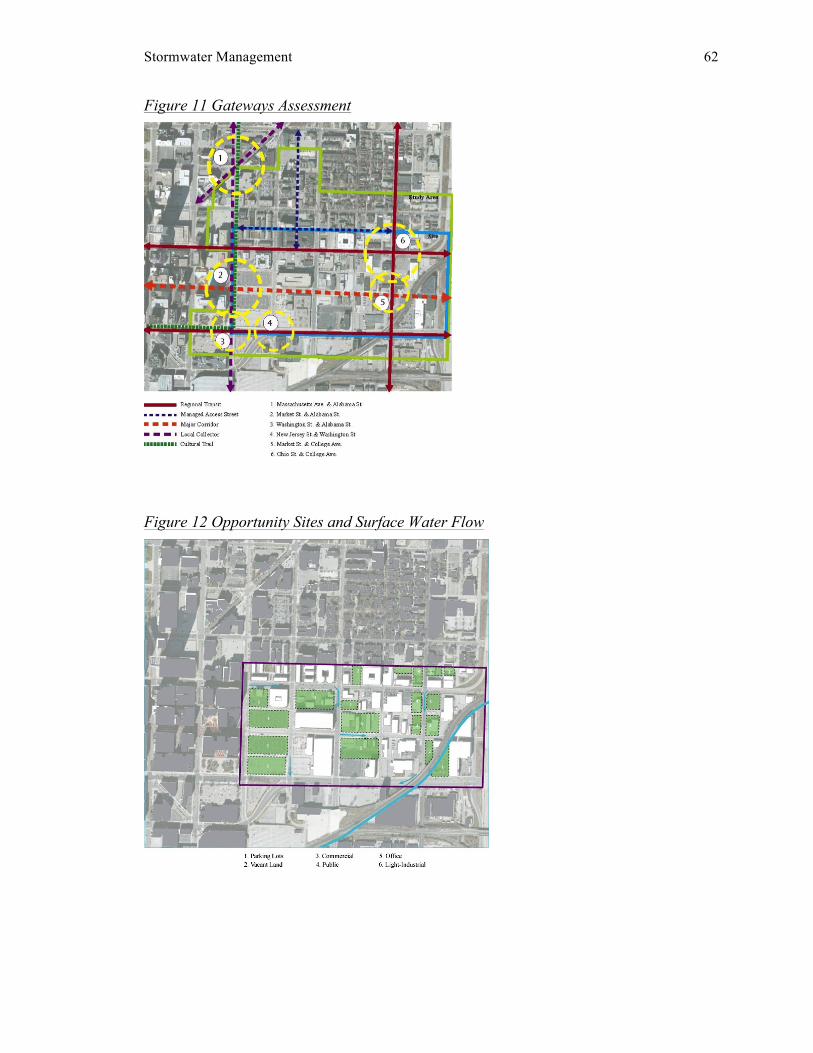
Stormwater Management 62
Figure 11 Gateways Assessment
Figure 12 Opportunity Sites and Surface Water Flow

Stormwater Management 63
4.7 Building Typologies Building types in Noble Green reflect the character of more recent development in
the Cole Noble district. The premise for each building’s orientation, height, density, and
massing of was gained from the understanding of underlying block patterns. The
surrounding context, specifically historic Lockerbie Square, played an influential role in
the transition of building scales. If Noble Green was divided longitudinally into three
equal sub-districts, buildings located in the upper sub-district could be generally
described as low-rise residential, based on the residential neighborhoods that exist north
of the district. Buildings located in the middle sub-district could be described as mid-rise
mixed-use residential, and buildings in the lower sub-district as mid to high-rise
commercial mixed-use.
Figure 13 Connections and Proposed Destinations
Individual buildings help to organize the design fabric of an area and distinguish
character neighborhoods. Buildings are considered a major component of the green
infrastructure network in Noble Green due to the large volume of runoff rooftops
contribute to the combined sewer system.

Stormwater Management 64
Building types also influence the distribution of practices on-site, for instance donut
residential buildings provide the ability to employ rain gardens in central courtyards.
4.8 Street Typologies
Impervious streets generate substantial volumes of stormwater runoff.
Subsequently, streets present ideal conditions for implementing green infrastructure
practices designated for both storage and infiltration uses. The hierarchy of street types in
Noble Green expands upon the existing street pattern, with the addition of pedestrian
priority streets and water-permeable, multi-modal alleys. Street types are classified by
design characteristics, which can be representative of different green infrastructure
practices. For example, Market Street redesigned as a boulevard arterial with linear rain
gardens in the center and tree box planters installed along the perimeters, serves the dual
purpose of reducing the rate of runoff and calming vehicle traffic. Social movements are
indirectly driven by street patterns. The redesigned system of streetscapes in this project
stimulates pedestrian movement and emphasizes interconnectivity through the use of
aesthetic green infrastructure practices.
Figure 14 Proposed Street Hierarchy and Building Types

Stormwater Management 65
4.9 Block Typologies
The concept behind the formation of different block types in Noble Green was
space activation. Analyzing existing block and social patterns to identify where gaps in
activity occur helped facilitate the process of programming opportunity sites. Edge
conditions can contribute to activity gaps and subsequently affect how a block is utilized
based on factors of accessibility, connectivity, and visibility. Through infill and retrofit
development, block types are redefined by functionality. For example, the union plaza
block in this project re-activated the space to serve the purpose of central place. Block
types are also an important component of a green infrastructure network based on
functionality and the use of space. For instance, commercial or mixed-use blocks may
require more impervious surface coverage compared to residential blocks, therefore, the
range of appropriate practices may differ.
Open space blocks provide natural characteristics ideal for infiltration-based
practices, whereas parking lot retrofits provide sufficient space for storage measures. The
block types featured in Noble Green establish a mixture of district-wide destinations and
form connections between identifiable places. The following section, Summary and
Implementation, explains the integration of green infrastructure practices with site-
specific conditions and design principles at the block level.
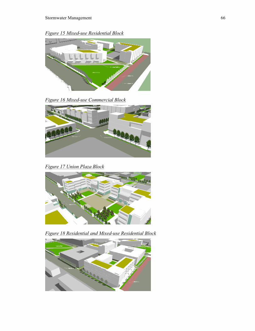
Stormwater Management 66
Figure 15 Mixed-use Residential Block
Figure 16 Mixed-use Commercial Block
Figure 17 Union Plaza Block
Figure 18 Residential and Mixed-use Residential Block

Stormwater Management 67
4.10 Development Program The urban development program for Noble Green reflects a qualitative approach
to the redevelopment of the Cole Noble district. Influential factors of the program
included, increasing the mixture of land uses, improving pedestrian-friendly connections,
and creating a balance between the built environment and natural systems.
Figure 19 Proposed Land Use Plan
Figure 20 Development Program
Stormwater Management 68
5.0 Summary and Implementation The summary and implementation section of this creative project applies green
infrastructure practices in conjunction with the urban design, redevelopment plan
described in the preceding section. The selection of practices and corresponding
implementation locations can aesthetically supplement the design principles employed in
a space. Green infrastructure practices present opportunities to improve the qualitative
aspects of a place as well as the quantitative aspects by reducing the rate and volume of
stormwater runoff. In addition to knowledge gained from the literature review, the case
study findings played a significant role in the selection and implementation process.
5.1 Selection of Green Infrastructure Practices
This section illustrates the incorporation of green infrastructure practices with site
design for a proposed block type in Noble Green. The Union Plaza block demonstrates a
system of green infrastructure practices employed both on-site and off-site. Based on the
goal to reduce combined sewer overflow and protect water quality, two general targets
were determined to guide the selection of green infrastructure practices. The first target
concerns the rate of runoff, and the second target concerns runoff volume. The
workhorses of the system are tree box planters and pervious concrete, pavers, and gutters.
Other featured practices include extensive green roofs, rain gardens, and cisterns.
Stormwater Management 69
Stormwater runoff can be stored under surfaces covered with pervious pavers
and/or pervious concrete. Tree box planters and pervious gutters also allow runoff storage
by installing a layer of porous material, such as gravel, below ground. The four
workhorses are considered inlet measures for storing stormwater runoff, ultimately
reducing the volume of runoff. Cisterns are used for storing runoff generated from
conventional rooftops and green roofs. Stormwater retained in cisterns can be reclaimed
for uses such as irrigation. Infiltration measures often entail landscaping based on the
capacity to detain and treat runoff before it is conveyed to storm sewers. The runoff rate
slows as it passes through a composition of porous materials such as gravel and/or soil.
Infiltration measures could serve as partitions for stormwater runoff by filtering out and
absorbing harmful stormwater nutrients.
The block design for the Noble Green Union Plaza exemplifies a combination of
green infrastructure practices that retain and detain stormwater runoff through storage
and infiltration measures. Runoff is stored beneath pervious pavers used to define the
plaza space. Pervious gutters alongside streets intercept and covey runoff to porous
gravel installed underground. Tree box planters along sidewalks and adjacent to pervious
gutters filter stormwater through a grate to the sub-storage box. Sidewalks resurfaced
with pervious concrete also captures stormwater to be stored underground before it is
released into storm sewers or surrounding soil. Urban environments are ideal for
installing pervious practices with underground storage as high fractions of impervious
surfaces exist. Extensive impervious surfaces provide advantageous locations for
substantially reducing the rate and volume of stormwater runoff.
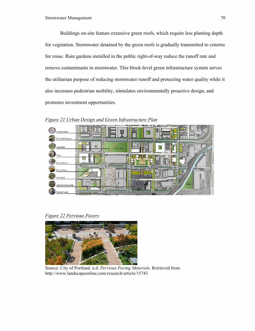
Stormwater Management 70
Buildings on-site feature extensive green roofs, which require less planting depth
for vegetation. Stormwater detained by the green roofs is gradually transmitted to cisterns
for reuse. Rain gardens installed in the public right-of-way reduce the runoff rate and
remove contaminants in stormwater. This block-level green infrastructure system serves
the utilitarian purpose of reducing stormwater runoff and protecting water quality while it
also increases pedestrian mobility, stimulates environmentally proactive design, and
promotes investment opportunities.
Figure 21 Urban Design and Green Infrastructure Plan
Figure 22 Pervious Pavers
Source: City of Portland. n.d. Pervious Paving Materials. Retrieved from http://www.landscapeonline.com/research/article/15743

Stormwater Management 71
Figure 23 Pervious Concrete
Source: Green Infrastructure Digest. n.d. Pervious Curb and Gutter. Retrieved from http://hpigreen.com/tag/curb-and-gutter/ Figure 24 Pervious Concrete
Source: Irving Materials Inc. n.d. Pervious Alleyway. Retrieved from http://www.irvmat.com/CaseStudy.asp?csid=59 Figure 25 Tree Box Planter
Source: City of Milton. n.d. Tree Box Filter. Retrieved from http://www.neponset.org/projects/stormwater/attachment/treeboxfiltercatchbasin2/

Stormwater Management 72
Figure 26 Rain Garden
Source: City of Philadelphia. n.d. Stormwater Bumpout. Retrieved from http://www.phillywatersheds.org/green_infrastructure/tools/stormwater_bumpout Figure 27 Cistern
Source: City of Chicago. 2003. Harvesting Stormwater. Retrieved from http://www.werf.org/liveablecommunities/studies_chic_il.htm Figure 28 Extensive Green Roof
Source: Elevated Landscape Technologies. n.d. Residential Green Roof. Retrieved from http://www.nachi.org/green-roof-inspection.htm

Stormwater Management 73
5.2 Block-level Implementation
The Noble Green Union Plaza block showcases a wide range of green
infrastructure practices both on and off-site. Located on the redesigned boulevard arterial,
the plaza is accessible by various modes of transportation. The space depicts urban design
principles including mixed-use buildings, a civic realm, and a pedestrian-safe zone. The
Union Plaza design process started with determining specific targets for reducing the rate
and volume of stormwater runoff. The storage target was established by calculating the
water quality volume for the site post-redevelopment. The two proposed mixed-use
residential buildings on the site total 6,752.93 square feet. The total square footage of
land equates to 83,670. Subtracting the total building square footage from the total land
square footage equals approximately 1.8 acres.
The following formula was used to the compute water quality volume:
(WQv): [(P)(Rv)(A)(43,560 SF/A]/12
Where: P = inches of rain, Rv =rate of volume, and A = acres of impervious surface.
The rate of volume (Rv) was calculated using the formula:
0.009(I)+0.05 where: I = percent of impervious area.
The percent of impervious area used to calculate the rate of volume was 85%, as
referenced on page 20 in the City of Indianapolis Stormwater Specifications Manual
(2011). Based on local standards and professional input, the following values were used
for this project:
P = 1.0, Rv = 0.815, A = 1.8
The target storage for the site equates to approximately 5,300 square feet at 1 cubic foot
per square feet of storage.

Stormwater Management 74
The perimeter of the site and bordering streets offer sizeable off-site opportunities
for green infrastructure. Existing streets in the district are almost all entirely impervious,
providing ample opportunities for stormwater retrofits in the right-of-way and/or
roadbed. Adjoining streets include Market Street, East Street, Wabash Street, and Park
Avenue. The distribution of green infrastructure practices off-site conveys streetscape
characteristics that help define the different types. For this project, Wabash Street is a key
segment of the permeable alley system. Pervious pavers with sub-surface storage validate
the system’s permeability and define the alley street type. Appropriate practices for each
street were determined based on a street’s proposed traffic pattern, right-of-way width,
and linear footage.
5.3 Project Summary
The Noble Green project expresses the vision for district-wide stormwater
management through the use of green infrastructure practices joined with infill and
retrofit development. Opportunity sites were selected based on the potential to
incorporate urban design principles that consider social and economic vitality with green
infrastructure practices that address combined sewer overflows and water quality issues.
Locations susceptible to green infrastructure have high percentages of impervious surface
coverage. Streets demonstrate the highest level of visible evidence due to the expanse of
available space to implement a variety of green infrastructure practices. The proposed
functionality of a block influenced the selection of practices based on a site’s target
storage capacity. Identifying two main implementation zones helped delineate practices
appropriate for on-site and/or off-site installation.

Stormwater Management 75
The urban design concept for Noble Green developed from the initial vision of
creating a network of green infrastructure practices through a system of linkages. The
network was contingent upon spatial connections and contextual relationships.
Relationships between block types and buildings were established through infill
development and the application of design principles. Streets provided the necessary
framework to form connections, with the addition of pedestrian walkways and an alley
system to provide access to destinations. Incorporating green infrastructure practices with
the fundamental components of the design fabric—buildings, blocks, and streets—led to
the formation of an aesthetically pleasing network of practices for managing stormwater
runoff.
5.4 Future Research
Research findings support that the green infrastructure approach to stormwater
management is increasing in popularity among urban cities and towns. Furthermore, the
wide range of practices presents opportunities to address related social, environmental,
and economic issues. To encourage private developers to invest in green infrastructure,
communities should consider a mix of policy tools. Additional research concerning
regulations and/or incentives to promote stormwater practices on a larger scale is
essential to promote this approach in the private sector. Establishing successful
management plans to preserve the longevity of green infrastructure practices is also
worthwhile. Communities facing economic concerns surrounding stormwater runoff may
be more inclined to initiate a partnership program that involves integrating green
infrastructure practices with projects administered by both public and private entities.

Exploring the potential of hybrid project goals and objectives and reducing the costs of
green infrastructure programs is critical for advancing this approach to stormwater
management at the local level.

Stormwater Management 77
BIBLIOGRAPHY Booth, D. B., & Jackson, R. C. (1997). Urbanization of Aquatic Systems: Degradation
Thresholds, Stormwater Detection, and the Limits of Mitigation. Journal of the
American Water Resources Association , 33 (5), 1077-1090.
Brown, R. R. (2008). Local Institutional Development and Organizational Change for
Advancing Sustainable Urban Water Futures. Environmental Management .
Center for Watershed Protection. (2010, August). Department of Environmental
Conservation. Retrieved January 11, 2013, from New York State Stormwater
Management Design Manual: http://www.dec.ny.gov/chemical/29072.html
Citizens Energy Group. (2006). Combined Sewer Overflow. Retrieved January 2013,
from Long Term Control Plan:
http://www.citizensenergygroup.com/pdf/ConsentDecree.pdf
City of Indianapolis. (2003, March ). Retrieved from Stream Reach Characterization and
Evaluation Report: http://cms.indygov.org/apps/dpw/2004/2-7.pdf
City of Indianapolis Department of Public Works . (2006). Citizens Energy Group .
Retrieved January 2013, from Long Term Control Plan :
http://www.citizensenergygroup.com/Wastewater/LongTermControlPlan.aspx

Stormwater Management 78
City of Indianapolis. (2011, January ). Stormwater Specifications Manual. Retrieved
January 10, 2013, from Chapter 200: Hydrology:
http://www.indy.gov/eGov/City/DPW/Business/Specs/Documents/Chapter%2020
0.pdf
City of Kansas City. (2009). Kansas City,Missouri Overflow Control Plan Overview.
Water Services Department, Kansas City. City of Philadelphia; U.S.
Environmental Protection Agency. (2012, April 10). Retrieved January 2013,
from Green City, Clean Waters Partnership Agreement:
http://phillywatersheds.org/doc/EPA_Partnership_Agreement.pdf
Comstock, S. R., & Wallis, C. (2003). The Maryland Stormwater Management Program
A New Approach to Stormwater Design. Retrieved January 12, 2013, from
http://water.epa.gov/polwaste/nps/stormwater/upload/2003_03_26_NPS_natlstor
mwater03_07Comstock.pdf
DeBusk, K., Hunt, W. F., Sydorovych, O., & Hatch, U. (2010). Watershed Retrofit and
Management Evaluation for Urban Stormwater Management Systems in North
Carolina. Journal of Contemporary Water Research & Education (146), 64-74.
Hammer, T. R. (1972). Stream Channel Enlargement Due to Urbanization. Water
Resources Research , 8 (6), 1530-1540.
Jacob, J. S., & Lopez, R. (2009). Is Denser Greener? An Evaluation of Higher Density
Development as an Urban Stormwater-Quality Best Management Practice.
Journal of the American Water Resources Association , 45 (3), 687-701.

Stormwater Management 79
Kapowitz, M. D., & Lupi, F. (2011). Stakeholder preferences for best management
practices for non-point source pollution and stormwater control. Landscape and
Urban Planning , 364-372.
Klein, R. D. (1979). Urbanization and Stream Quality Impairment. Journal of the
American Water Resources Association , 15 (4), 948-963.
Metro Water Services. (2009). The Metropolitan Government of Nashville and Davidson
County Green Infrastructure Master Plan. Nashville. Metropolitan Sewer District
of Greater Cincinnati. (2012, May ). Lick Run Watershed Master Plan. Retrieved
January 2013, from Project Groundwork :
http://www.projectgroundwork.org/downloads/lickrun/lick_run_master_plan.pdf
National Risk Management Research Laboratory, EPA Office of Research and
Development. (2002, September). Considerations in the Design of Treament Best
Management Practices (BMPs) to Improve Water Quality. Retrieved January 8,
2013, from Risk Management Research :
http://www.epa.gov/nrmrl/pubs/600r03103.html
National Weather Service . (n.d.). National Weather Service Forecast Office. Retrieved
January 14, 2013, from Observed Weather Reports for Indianapolis, IN:
http://www.nws.noaa.gov/climate/index.php?wfo=ind
Philadelphia Water Department. (2009, September 01). Green City, Clean Waters.
Retrieved January 10, 2013, from Philadelphia Water Department:
http://www.phillywatersheds.org/what_were_doing/documents_and_data/cso_lon
g_term_control_plan
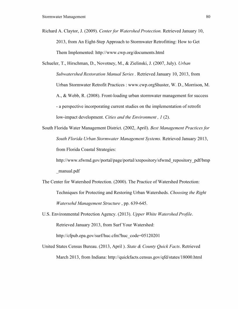
Stormwater Management 80
Richard A. Claytor, J. (2009). Center for Watershed Protection. Retrieved January 10,
2013, from An Eight-Step Approach to Stormwater Retrofitting: How to Get
Them Implemented: http://www.cwp.org/documents.html
Schueler, T., Hirschman, D., Novotney, M., & Zielinski, J. (2007, July). Urban
Subwatershed Restoration Manual Series . Retrieved January 10, 2013, from
Urban Stormwater Retrofit Practices : www.cwp.orgShuster, W. D., Morrison, M.
A., & Webb, R. (2008). Front-loading urban stormwater management for success
- a perspective incorporating current studies on the implementation of retrofit
low-impact development. Cities and the Environment , 1 (2).
South Florida Water Management District. (2002, April). Best Management Practices for
South Florida Urban Stormwater Management Systems. Retrieved January 2013,
from Florida Coastal Strategies:
http://www.sfwmd.gov/portal/page/portal/xrepository/sfwmd_repository_pdf/bmp
_manual.pdf
The Center for Watershed Protection. (2000). The Practice of Watershed Protection:
Techniques for Protecting and Restoring Urban Watersheds. Choosing the Right
Watersehd Management Structure , pp. 639-645.
U.S. Environmental Protection Agency. (2013). Upper White Watershed Profile.
Retrieved January 2013, from Surf Your Watershed:
http://cfpub.epa.gov/surf/huc.cfm?huc_code=05120201
United States Census Bureau. (2013, April ). State & County Quick Facts. Retrieved
March 2013, from Indiana: http://quickfacts.census.gov/qfd/states/18000.html

Stormwater Management 81
United States Department of Agriculture . (n.d.). Natural Resources Conservation Service
. Retrieved January 12, 2013, from Web Soil Survey :
http://websoilsurvey.nrcs.usda.gov/app/WebSoilSurvey.aspx
Wong, T. H., & Eadie, M. L. (2000). Water sensitive urban design: A praradigm shift in
urban design. Retrieved January 15, 2013, from Informit:
http://search.informit.com.au/documentSummary;dn=519426635188728;res=IEL
ENG


![Low Impact Development [presenters name] [presentation date] Integrated Management Practices Controlling Stormwater Quality and Quantity using](https://img.pdfslide.net/doc/110x75/56649f2e5503460f94c47dda/low-impact-development-presenters-name-presentation-date-integrated-management.jpg)