Embed Size (px)
Citation preview

African Journal of Environmental Science and Technology Vol. 4(4), pp. 234-249, April 2010 Available online at http://www.academicjournals.org/AJEST ISSN 1991-637X © 2010 Academic Journals
Full Length Research Paper
Integrated study for automobile wastes management and environmentally friendly mechanic villages in the
Imo River basin, Nigeria
Michael A. Nwachukwu1*, Huan Feng1 and Kennedy Achilike2
1Department of Earth and Environmental Studies,
Montclair State University, New Jersey, U.S.A.
2Department of Physics, Abia State University Uturu, Nigeria.
Accepted 20 January, 2010
Despite the overwhelming advantages of mechanic villages, their heavy metal pollution of soil due to poor waste management is causing serious ecological and public health concerns. Analytical results show that heavy metal concentrations (mgkg
-1) above background levels in the upper 100 cm soil
profiles of the Okigwe, the Orji and the Nekede mechanic villages in the Imo River basin, collectively range from 748 - 70,606 (± 23021) for Fe; 99-1090 (± 176.8) for Pb; 186 - 600 (± 49.7) for Mn; 102 - 1001(± 208) for Cu; 8 - 23 (± 6.3) for Cd; 4 - 27 (± 4.2) for Cr; and 3 - 10 (±2.2) for Ni. The most abundant metals of environmental concerns are Pb, Mn and Cu, in the order of Pb > Mn > Cu. For proper waste management and environmentally friendly mechanic villages, mechanic villages should have emission testing facilities, concrete floor workshops, toilet facilities, tarred roads and drainage channelled to one or more three-phase storm water treatment facilities. We recommend infiltration method in the sandy areas, and detention method in the shale areas. A combination of the two methods can be used in the transition zones of the basin. The infiltration method is not applicable at Okigwe due to the high clay/silt content (47 - 64%) and presence of an underlying clay bed, despite the initially high infiltration rate (38.1 cm/h). Weathered layer (0 - 7.4 m) across Orji and Nekede, and (0 - 4 m) at Okigwe is the most implicated in the soil pollution process. We further recommend: extended producer responsibility (EPR) for used motor oil, the use of local phyto - remediation plants sensitive to Pb, Mn and Cu, installation of groundwater monitoring wells, comprehensive waste management plan, standard guidelines for establishment of mechanic villages, code of practice, and continuous education for the mechanics. Key words: Soil contamination, storm water treatment, emission testing, EPR, heavy metals.
INTRODUCTION A mechanic village is an area of open land allocated to automobile repair workers in the vicinity of an urban centre. In Nigeria, for example, the mechanic village in Nekede has an area of 136 acres; one in Orji has 101 acres of land, and one in Okigwe has 74 acres of land. A typical city usually has one to three mechanic villages, in proportion to its population and activities, but some cities have more. With the progress of the automobile industries in Europe and the United States moving towards greener electric cars, the international trade in used motor vehicles is likely to increase. As a result, *Corresponding author. E-mail: [email protected]. edu. Tel: +1973-655-3456.
great numbers of used fuel - guzzling cars of all models are expected to stream into developing countries in this first quarter of the century. Urban areas will react to the increased supply by establishing more mechanic villages, and more developing countries may buy the mechanic village concept. The advantages of mechanic village over a city wide spread of mechanic workshops were originally conceived as: to save automobile owners’ the trouble of searching for mechanic specialists, to prevent motorists from falling into the hands of incompetent mechanics and to create opportunities for knowledge sharing among mechanics. They also serve as large scale skill acquisition centres for auto mechanics, auto-electricians, spray-painters, panel beaters and welders, spare parts fabricating and machine operators, spare parts dealers (old and new), particularly since the late 1980’s when the
Nwachukwu et al. 235
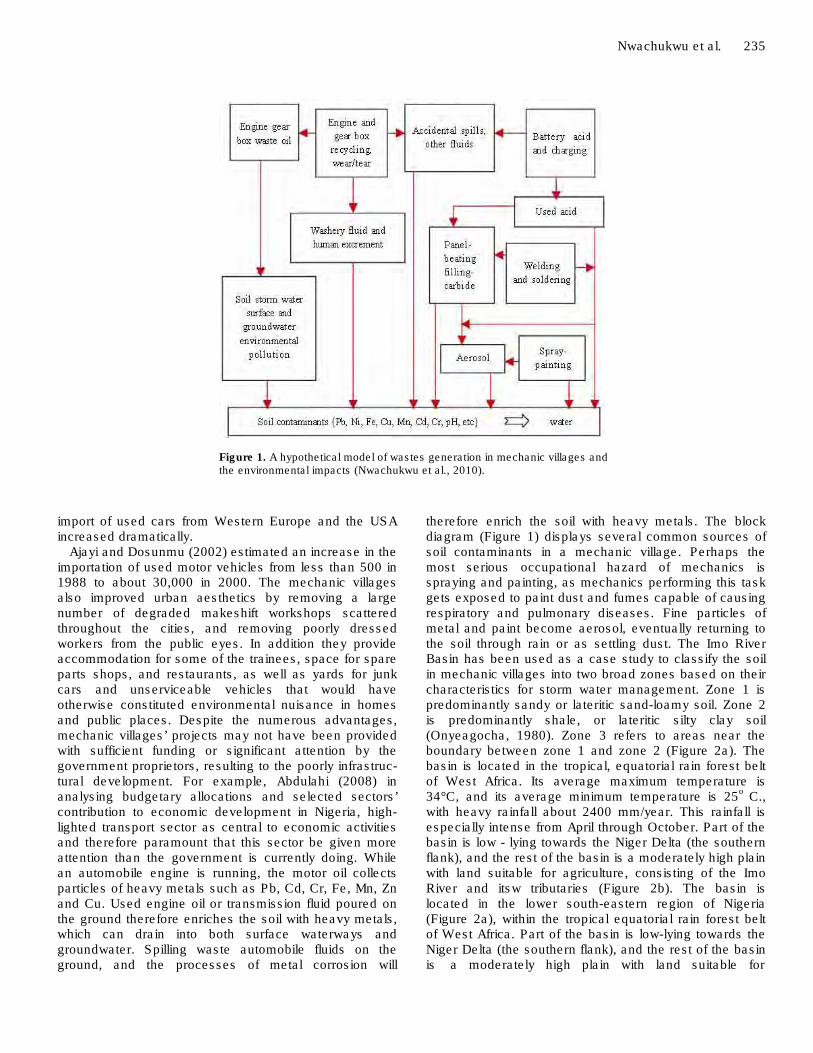
Figure 1. A hypothetical model of wastes generation in mechanic villages and the environmental impacts (Nwachukwu et al., 2010).
import of used cars from Western Europe and the USA increased dramatically.
Ajayi and Dosunmu (2002) estimated an increase in the importation of used motor vehicles from less than 500 in 1988 to about 30,000 in 2000. The mechanic villages also improved urban aesthetics by removing a large number of degraded makeshift workshops scattered throughout the cities, and removing poorly dressed workers from the public eyes. In addition they provide accommodation for some of the trainees, space for spare parts shops, and restaurants, as well as yards for junk cars and unserviceable vehicles that would have otherwise constituted environmental nuisance in homes and public places. Despite the numerous advantages, mechanic villages’ projects may not have been provided with sufficient funding or significant attention by the government proprietors, resulting to the poorly infrastruc-tural development. For example, Abdulahi (2008) in analysing budgetary allocations and selected sectors’ contribution to economic development in Nigeria, high-lighted transport sector as central to economic activities and therefore paramount that this sector be given more attention than the government is currently doing. While an automobile engine is running, the motor oil collects particles of heavy metals such as Pb, Cd, Cr, Fe, Mn, Zn and Cu. Used engine oil or transmission fluid poured on the ground therefore enriches the soil with heavy metals, which can drain into both surface waterways and groundwater. Spilling waste automobile fluids on the ground, and the processes of metal corrosion will
therefore enrich the soil with heavy metals. The block diagram (Figure 1) displays several common sources of soil contaminants in a mechanic village. Perhaps the most serious occupational hazard of mechanics is spraying and painting, as mechanics performing this task gets exposed to paint dust and fumes capable of causing respiratory and pulmonary diseases. Fine particles of metal and paint become aerosol, eventually returning to the soil through rain or as settling dust. The Imo River Basin has been used as a case study to classify the soil in mechanic villages into two broad zones based on their characteristics for storm water management. Zone 1 is predominantly sandy or lateritic sand-loamy soil. Zone 2 is predominantly shale, or lateritic silty clay soil (Onyeagocha, 1980). Zone 3 refers to areas near the boundary between zone 1 and zone 2 (Figure 2a). The basin is located in the tropical, equatorial rain forest belt of West Africa. Its average maximum temperature is 34°C, and its average minimum temperature is 25
o C.,
with heavy rainfall about 2400 mm/year. This rainfall is especially intense from April through October. Part of the basin is low - lying towards the Niger Delta (the southern flank), and the rest of the basin is a moderately high plain with land suitable for agriculture, consisting of the Imo River and itsw tributaries (Figure 2b). The basin is located in the lower south-eastern region of Nigeria (Figure 2a), within the tropical equatorial rain forest belt of West Africa. Part of the basin is low-lying towards the Niger Delta (the southern flank), and the rest of the basin is a moderately high plain with land suitable for

236 Afr. J. Environ. Sci. Technol.
Figure 2a. Map of Nigeria showing the study area; b. Drainage map of study area; c. Geologic map of Imo River Basin (Nwachukwu et al., 2010),
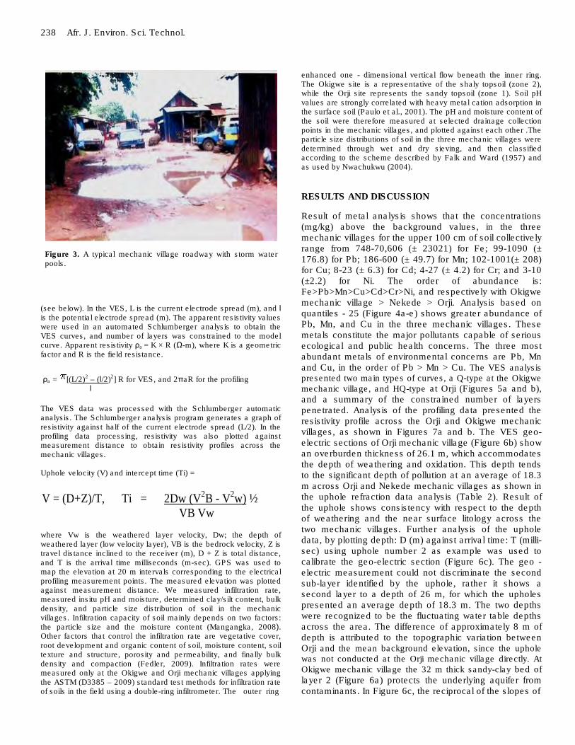
agriculture, consisting of the Imo River and its tributaries (Figure 2b). The Imo River Basin has been used as a case study to classify soil in mechanic villages into two broad zones based on their characteristics for storm water management. Zone 1 is predominantly sandy or lateritic sand-loamy soil. Zone 2 is predominantly shaly, or lateritic silty-clay soil (Onyeagocha, 1980). Zone 3 refers to areas near the boundary between zone 1 and zone 2 (Figure 2c). Its average maximum temperature is 34°C, and its average minimum temperature is 25°C., with heavy rainfall about 2400 mm/year. The rainfall is especially intense from April through October, leaving behind stagnant storm water pools along the poorly developed earth roads of the mechanic villages (Figure 3). Land ownership systems, farming systems, poor planning, and relatively small land mass with high population density and growth, are probably responsible to pockets of farmlands mixing with residential and commercial areas. This situation and poor waste disposal systems enhances pollution risks in the basin. Igbozurike et al. (2009) tested cassava plant tubers harvested from an abandoned sewage sludge dump near Owerri, using AAS, and observed high heavy metal concentrations of 38.25, 138.7, 125.8, 5.50 and 3.60 mg kg
-1 respectively
for Ni, Zn, Cu, Pb, and Cd, compared to their background levels. This dump was not active; was abandoned for three year prior to the study, and this may have reduced
the concentration levels following diffusion, infiltration, and other bio - extraction processes that may have taken place in the contaminated soil. This study examines three polluting sites: the Orji and Nekede mechanic villages located in the Owerri urban area, and the Okigwe mechanic village in the Okigwe urban area. There is also the Orlu and the Alaoji mechanic villages. Orlu is characterised by shaly topsoil similar to Okigwe, while Alaoji has sandy topsoil similar to Nekede and Orji, and the two are not discussed.
In Nigeria, soil pollution problems associated with automobile wastes has been reported (Onianwa et al., 2001; Ipeaiyeda et al., 2007; Iwegbue, 2007; Adie and Osibanjo, 2009). Iwegbue (2007) studied metal fractionation in soil profiles at automobile mechanic waste dumps around Portharcourt, and observed that the metals present were relatively mobile, but more in the surface than in the subsurface. The exception was chromium, which migrated fastest at depths between 15 cm and 30 cm, and in the order of decreasing mobility, he identified six metals: Cd > Zn > Pb > Cu > Cr > Ni. However, automobile waste dumps will consist predominantly of auto body scraps (Al), pieces of mild steel (Fe), electrical components and wires (Cu), short of other occupational wastes of mechanic villages as illustrated in Figure 1. Ipeaiyeda et al. (2007) investigating the heavy metals contamination of topsoil

and dispersion in the vicinities of reclaimed auto - repair workshops in Iwo Nigeria due to poor management of automobile wastes. He found Pb (133±66 mg/kg) as the most significant contaminant, followed by Ni (11.5±3.3 mg/kg), and Hg (9.4±4.6 mg/kg). He observed a general trend of dispersion as Pb>>Ni>Hg>Cr>>Zn at the sites. Again this investigation was conducted at isolated reclaimed automobile workshops, and the results are expected to vary with that obtained in operational mechanic villages such as the three under investigation. Waste generation and metal contamination of soil in a mechanic village will largely depend on workshop and operational density. For example; the workshop density at Okigwe mechanic village is obtained as follows: Total number of mechanics = 640, at average of three mechanics per workshop space; consist of one or two mechanical workers, with one electrical or one panel beater, and/or one spray - painter. Active working area is 60% of drainage area. Workshop density of Okigwe mechanic village: Workshop density = (No. of mechanics)/3 Drainage area of Mv
Mv = mechanic village, at 3 mechanics assumed per workshop (apprentices excluded) Number of workshops = 640/3 = 213. Drainage area = 720 x 340 m
2, = 74 acres
Workshop density of Okigwe = 213/74 = 3 workshops/acre. Orji = 193/100.8 = 2 workshop/acre for 580 mechanics, and Nekede = 333/136 = 3 workshops/acre approximately for 1000 mechanics. Liu et al. (2007) observed that heavy metal concen-trations in soils are usually highest close to the source, declining with both distance and depth, and Novak and Watts (2004) found that metal hydroxides and water increase the sorption capacity of soils, which implies that spilling used acid on the ground in the mechanic villages will increase soil acidity and the sorption capacity. At the centre of this study is storm water management.
Lack of storm water treatment facilities in mechanic villages indicates poor environmental awareness, because infiltration and detention basins are relatively cheap to build and do not involve complex hydrological designs. Galli (1992), Hidding (1996), Young (1996), Pitt and Shirley (2008), Gobel et al. (2004) and Obrompta and Kados (2007) have all discussed the use of storm water management facilities to improve environmental quality. This paper presents an occupational waste management plan for environmentally friendly mechanic villages in Nigeria, applicable to other regions where the mechanic village concept is in practice following a number of field and laboratory measurements. These measurements include quantitative analysis of metal enrichment, electrical resistivity by vertical electric sounding (VES) and profiling, elevations, slopes, infiltration rates and drainage pathways, as well as grain
Nwachukwu et al. 237 size distribution, moisture content and pH of the soil at Okigwe, Orji and Nekede mechanic villages of the Imo River basin. METHODS OF STUDY
We started with routine observation of activities that go on in the three mechanic villages. Informally, we interviewed some mechanics in groups of about twenty to thirty persons who were fascinated with our field measurements and instruments and convened severally at our base stations to find out what was going on. Individuals and the union executives were also interviewed, and we had an in - house workshop in each of the mechanic villages based on their occupational health and safety, during which we emphasized on the needs for proper disposal of their occupational wastes. We particularly lamented on the usual practice of spilling waste engine and transmission oil on the ground, and the health implications of their usual practice of using mouth to retrieve petrol or diesel from tanks via a siphon, and introducing petrol to the carburettors of motor vehicles under repair using mouth. We investigated the infrastructure, and the code of practice that exist in the three mechanic villages. Our focus group consists of the mechanics, their apprentices, and the associated workers that include spare parts dealers and food vendors, with an estimated average population of about 850 persons in each of the mechanic villages. This was followed by radio/TV commentaries, and publications in the local newspapers.
Only one mechanic was found to have put - in up to 40 years of practice, it was difficult to find mechanics with practice history of 30 to 40 years in the mechanic villages investigated. Probably these mechanics age out prematurely as a result of poor health, following long term exposure to toxicity. Future research is necessary in this direction. Dioka et al. (2004) investigated blood Pb-level among a group of students on one side, and a group of mechanics drafted from a mechanic village at Nnewi near the Imo River basin. Results of their study showed that occupational exposure of human subjects to lead in petrol increases the concentrations of uric acid (357 ± 123 µ mol/L) and phosphate (1.5 ± 0.5 m mol/L).This they said may compromise liver and renal function. The high Pb blood level of the mechanics is been attributed to their continuous exposure to the Nigeria petrol and petroleum products containing tetraethyl lead. Analysis of Pb, Cd, Fe, Mn, Cu, Ni and Cr enrichments in the soil layers (L1: 0 -10 cm, L2: 10 - 20 cm and L3: 90 - 100 cm) was carried out using atomic absorption spectrometer (AAS). Haswell (1991), Ivanova et al. (1994), Anthony et al. (2003), Mico et al. (2007) and EPA document SW - 846, have all confirmed the adequacy of digestion method with AAS. Nine composite samples, each made of three replicate core samples collected from Okigwe, Nekede, and Orji mechanic villages and nine similar samples collected from the background (500 m off the mechanic villages), against the direction of drainage were involved in the quantitative analysis. In the absence of a complete tool for inversion method such as 2 - D tomography, we mapped the topsoil and underlying lithology using vertical electric sounding (VES) technique. To map the lateral extent of metal enrichment in the mechanic villages, we combined electrical resistivity profiling with elevation measurements. All necessary precautions required in geo - electric survey were duly observed. For papers demonstrating the field techniques of VES and electrical profiling in site investigation, we refer the readers to Dobrin and Savit (1988), Telford et al. (1990) and Nwachukwu (1993). The VES result for Orji topsoil which is applicable to Nekede was matched with the analysis of shallow Uphole refraction data across Orji and Nekede obtained from Chevron Nigeria as contained in Nwachukwu (2003).
The apparent resistivity (Ω-m) at each measurement point was computed by multiplying the field resistance with a geometric factor
238 Afr. J. Environ. Sci. Technol.
Figure 3. A typical mechanic village roadway with storm water pools.
(see below). In the VES, L is the current electrode spread (m), and l is the potential electrode spread (m). The apparent resistivity values were used in an automated Schlumberger analysis to obtain the VES curves, and number of layers was constrained to the model curve. Apparent resistivity ρa = K × R (Ω-m), where K is a geometric factor and R is the field resistance.
ρa = [(L/2)2 – (l/2)2] R for VES, and 2πaR for the profiling l
The VES data was processed with the Schlumberger automatic analysis. The Schlumberger analysis program generates a graph of resistivity against half of the current electrode spread (L/2). In the profiling data processing, resistivity was also plotted against measurement distance to obtain resistivity profiles across the mechanic villages. Uphole velocity (V) and intercept time (Ti) =
V = (D+Z)/T, Ti = 2Dw (V2B - V
2w) ½
VB Vw where Vw is the weathered layer velocity, Dw; the depth of weathered layer (low velocity layer), VB is the bedrock velocity, Z is travel distance inclined to the receiver (m), D + Z is total distance, and T is the arrival time milliseconds (m-sec). GPS was used to map the elevation at 20 m intervals corresponding to the electrical profiling measurement points. The measured elevation was plotted against measurement distance. We measured infiltration rate, measured insitu pH and moisture, determined clay/silt content, bulk density, and particle size distribution of soil in the mechanic villages. Infiltration capacity of soil mainly depends on two factors: the particle size and the moisture content (Mangangka, 2008). Other factors that control the infiltration rate are vegetative cover, root development and organic content of soil, moisture content, soil texture and structure, porosity and permeability, and finally bulk density and compaction (Fedler, 2009). Infiltration rates were measured only at the Okigwe and Orji mechanic villages applying the ASTM (D3385 – 2009) standard test methods for infiltration rate of soils in the field using a double-ring infiltrometer. The outer ring
enhanced one - dimensional vertical flow beneath the inner ring. The Okigwe site is a representative of the shaly topsoil (zone 2), while the Orji site represents the sandy topsoil (zone 1). Soil pH values are strongly correlated with heavy metal cation adsorption in the surface soil (Paulo et al., 2001). The pH and moisture content of the soil were therefore measured at selected drainage collection points in the mechanic villages, and plotted against each other .The particle size distributions of soil in the three mechanic villages were determined through wet and dry sieving, and then classified according to the scheme described by Falk and Ward (1957) and as used by Nwachukwu (2004).
RESULTS AND DISCUSSION
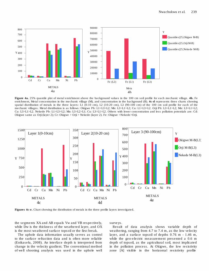
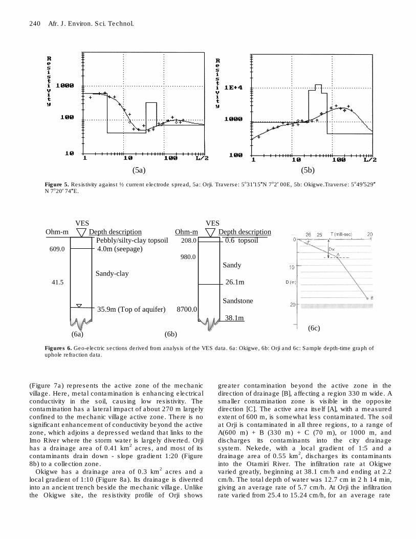
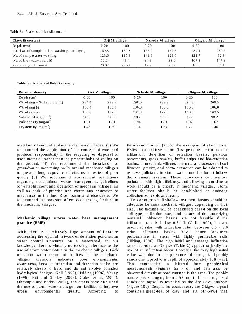
Result of metal analysis shows that the concentrations (mg/kg) above the background values, in the three mechanic villages for the upper 100 cm of soil collectively range from 748-70,606 (± 23021) for Fe; 99-1090 (± 176.8) for Pb; 186-600 (± 49.7) for Mn; 102-1001(± 208) for Cu; 8-23 (± 6.3) for Cd; 4-27 (± 4.2) for Cr; and 3-10 (±2.2) for Ni. The order of abundance is: Fe>Pb>Mn>Cu>Cd>Cr>Ni, and respectively with Okigwe mechanic village > Nekede > Orji. Analysis based on quantiles - 25 (Figure 4a-e) shows greater abundance of Pb, Mn, and Cu in the three mechanic villages. These metals constitute the major pollutants capable of serious ecological and public health concerns. The three most abundant metals of environmental concerns are Pb, Mn and Cu, in the order of Pb > Mn > Cu. The VES analysis presented two main types of curves, a Q-type at the Okigwe mechanic village, and HQ-type at Orji (Figures 5a and b), and a summary of the constrained number of layers penetrated. Analysis of the profiling data presented the resistivity profile across the Orji and Okigwe mechanic villages, as shown in Figures 7a and b. The VES geo-electric sections of Orji mechanic village (Figure 6b) show an overburden thickness of 26.1 m, which accommodates the depth of weathering and oxidation. This depth tends to the significant depth of pollution at an average of 18.3 m across Orji and Nekede mechanic villages as shown in the uphole refraction data analysis (Table 2). Result of the uphole shows consistency with respect to the depth of weathering and the near surface litology across the two mechanic villages. Further analysis of the uphole data, by plotting depth: D (m) against arrival time: T (milli-sec) using uphole number 2 as example was used to calibrate the geo-electric section (Figure 6c). The geo - electric measurement could not discriminate the second sub-layer identified by the uphole, rather it shows a second layer to a depth of 26 m, for which the upholes presented an average depth of 18.3 m. The two depths were recognized to be the fluctuating water table depths across the area. The difference of approximately 8 m of depth is attributed to the topographic variation between Orji and the mean background elevation, since the uphole was not conducted at the Orji mechanic village directly. At Okigwe mechanic village the 32 m thick sandy-clay bed of layer 2 (Figure 6a) protects the underlying aquifer from contaminants. In Figure 6c, the reciprocal of the slopes of
Nwachukwu et al. 239
0
100 200
300 400
500 600 700 800
Y
Cd Cr Cu Mn Ni Pb
METALS
4a
0 10000 20000 30000 40000 50000 60000 70000 80000 90000
Y
Fe (L2) Fe (L1) Fe (L3)
Meta
4b
Y Quantiles(25,Okigwe M-B)
Quantiles(25,Orji M-B)
Quantiles(25,Nekede M-B)
Figure 4a. 25% quantile plot of metal enrichment above the background values in the 100 cm soil profile for each mechanic village. 4b. Fe enrichment, Metal concentration in the mechanic village (M), and concentration in the background (B). 4c-d represents three charts showing spatial distribution of metals in the three layers: L1 (0-10 cm), L2 (10-20 cm), L3 (90-100 cm) of the 100 cm soil profile for each of the mechanic villages. Metal distribution is as follows: Okigwe Pb: L1>L3>L2; Mn: L3>L1>L2; Cu: L1>L3>L2. Orji Pb: L3>L1>L2; Mn: L3>L1>L2; Cu: L3>L1>L2. Nekede Pb: L1>L3>L2; Mn: L3>L2>L1; Cu: L3>L1>L2. Others with lower concentration and less pollution potentials are: Cd: Okigwe same as Orji (layer 2); Cr: Okigwe > Orji > Nekede (layer 2). Fe: Okigwe >Nekede>Orji.
0
250
500
750
1000
1250
1500
Y
Layer 1(0-10cm)
Cd Cr Cu Mn Ni Pb
METALS
4c
0
50
100
150
200
250
300
350
Y
Layer 2(10-20 cm)
Cd Cr Cu Mn Ni Pb
METALS
4d
0
100
200
300
400
500
600
700
800
Y
Layer 3 (90-100cm)
Cd Cr Cu Mn Ni Pb
METALS
4e
Y
Okigwe M-B(L3)
Orji M-B(L3)
Nekede M-B(L3)
Figures 4c-e. Chart showing the distribution of metals in the three profile layers investigated.
the segments XA and AB equals Vw and VB respectively, while Dw is the thickness of the weathered layer, and OX is the most weathered surface topsoil or the first break.
The uphole data information usually serves as control to the surface refraction data and is often more reliable (Enikaselu, 2008). An interface depth is interpreted from change in the velocity gradient. The conventional method of well shooting analysis was used in the uphole well
surveys. Result of data analysis shows variable depth of
weathering, ranging from 4.7 to 7.4 m, as the low velocity layer, and a surface topsoil of depths 0.76 m - 1.46 m, while the geo-electric measurement presented a 0.6 m depth of topsoil, as the agricultural soil, most implicated in the pollution process. At Okigwe, the low resistivity zone [A] visible in the horizontal resistivity profile
240 Afr. J. Environ. Sci. Technol.
(5a) (5b)
Figure 5: Resistivity against ½ current electrode spread, 5a: Orji. Traverse: 5o31′15″N 7
o2′ 00E
Figure 5. Resistivity against ½ current electrode spread, 5a: Orji. Traverse: 5o31′15″N 7o2′ 00E, 5b: Okigwe.Traverse: 5o49′529″ N 7o20′ 74″E.
VES VES
Ohm-m Depth description Ohm-m Depth description
Pebbly/silty-clay topsoil 208.0 0.6 topsoil
609.0 4.0m (seepage) 980.0
Sandy
Sandy-clay
41.5 26.1m
Sandstone
35.9m (Top of aquifer) 8700.0
38.1m
(6a) (6b)
(6c) (6c)
Figures 6. Geo-electric sections derived from analysis of the VES data. 6a: Okigwe, 6b: Orji and 6c: Sample depth-time graph of uphole refraction data.
(Figure 7a) represents the active zone of the mechanic village. Here, metal contamination is enhancing electrical conductivity in the soil, causing low resistivity. The contamination has a lateral impact of about 270 m largely confined to the mechanic village active zone. There is no significant enhancement of conductivity beyond the active zone, which adjoins a depressed wetland that links to the Imo River where the storm water is largely diverted. Orji has a drainage area of 0.41 km
2 acres, and most of its
contaminants drain down - slope gradient 1:20 (Figure 8b) to a collection zone.
Okigwe has a drainage area of 0.3 km2 acres and a
local gradient of 1:10 (Figure 8a). Its drainage is diverted into an ancient trench beside the mechanic village. Unlike the Okigwe site, the resistivity profile of Orji shows
greater contamination beyond the active zone in the direction of drainage [B], affecting a region 330 m wide. A smaller contamination zone is visible in the opposite direction [C]. The active area itself [A], with a measured extent of 600 m, is somewhat less contaminated. The soil at Orji is contaminated in all three regions, to a range of A(600 m) + B (330 m) + C (70 m), or 1000 m, and discharges its contaminants into the city drainage system. Nekede, with a local gradient of 1:5 and a drainage area of 0.55 km
2, discharges its contaminants
into the Otamiri River. The infiltration rate at Okigwe varied greatly, beginning at 38.1 cm/h and ending at 2.2 cm/h. The total depth of water was 12.7 cm in 2 h 14 min, giving an average rate of 5.7 cm/h. At Orji the infiltration rate varied from 25.4 to 15.24 cm/h, for an average rate

Nwachukwu et al. 241
Figure 7a. Okigwe mechanic village electrical resistivity profile. Traverse in the direction of drainage (north to south). Coordinates: 05o49′529″ N 07o20′07″ E, A = active area, mean Resistivity = 467.5 ± 293 Ω-m.
Figure 7b. Orji mechanic village electrical resistivity profile. Traverse in the direction of drainage (West-East); Coordinates: 5o 31′ 15″ N, 7o 02′ 22″ E. Three impacted zones are shown: the active area (A), and zone (B) along the drainage, and a small zone (C) against the drainage. Mean Resistivity = 513 ± 519.
Figure 8a. Elevation profiles, 8a: Okigwe Mechanic village, along the same traverse shown in Figure 7a. The gradient at the village is about 1:10.
Figure 8b. Orji mechanic village, along the same traverse shown in Figure 7b. The gradient is 1:20.

242 Afr. J. Environ. Sci. Technol.
4.5
5
5.5
6
6.5
pH
(O
rji)
10 20 30 40 50 60 70 80
Moisture (%)
4
4.5
5
5.5
6
6.5
7
7.5
pH
(O
kigw
e)
0 10 20 30 40 50 60 70 80
Moisture (%)
(9a) (9b) Figure 9. Graph of pH against moisture content, 9a: Orji topsoil, and 9b: Okigwe topsoil. Table 1a. Analytical results of metal distribution per measurement layer in the 100 cm depths soil profile. Mechanic village (M) and local background value (B).
Metals B (mg/kg) M (mg/kg) B (mg/kg) M (mg/kg)
Okigwe Orji Nekede Okigwe Orji Nekede Okigwe Orji Nekede Okigwe Orji Nekede
0 - 10 cm layer 10 - 20 cm layer
Fe 50,613 32,151 14,795 121,219 42,709 45,289 50,613 32,151 14,795 121,219 42,709 45,289
Ni 21.5 14.5 11 24.7 24.8 18.3 21.5 14.5 11 24.7 24.8 18.3
Cd 22.5 18.5 16.5 42.5 31.5 32.5 22.5 18.5 16.5 42.5 31.5 32.5
Pb 469 359 309 1559 619 759 469 359 309 1559 619 759
Cu 280 249 258 1281 571 569 280 249 258 1281 571 569
Cr 13.7 8.6 8.2 26 19.5 16.8 13.7 8.6 8.2 26 19.5 16.8
Mn 471 341 374 817 696 627 471 341 374 817 696 627
Table 1b. Analytical results of metal distribution per measurement layer in the 100 cm depths soil profile. Mechanic village (M) and local background value (B).
Metals B (mg/kg) M (mg/kg)
Okigwe Orji Nekede Okigwe Orji Nekede
90 - 100 cm layer
Fe 80.045 14.225 27.927 114.641 20.595 46.079
Ni 14.5 9.5 10.5 24.5 16.5 18.5
Cd 23.5 11.5 17.5 40.5 33.5 25.5
Pb 409 189 279 659 520 580
Cu 257 200 213 837 500 594
Cr 28 20 18 38 24 28
Mn 258 180 158 858 648 728
of 18 cm/h (Table 2). Okigwe topsoil has a higher initial infiltration rate than Orji topsoil, but becomes impermeable in about 3 h as its moisture content
increases. Yang et al. (2006) have shown that rainfall intensity has a major effect on infiltration rate in the finer layer but limited effects in the coarser layer due to the

Nwachukwu et al. 243
Table 2a. Uphole refraction data between Orji and Nekede, amended from Nwachukwu (2003).
Uphole D1(m) D2(m) D3(m) Z1(m) Z2(m) Z3(m) T1
(m-s)
T2
(m-s)
T3
(m-s)
V1(m/s) V2(m/s) V3(m/s)
1 1.2 5.4 18.3 5.7 11.6 16.5 26.4 25.3 18.4 260.9 670.89 1888.8
2 1 4.7 18.3 5.9 13 16.6 20.0 27.0 18.8 347.3 657.6 1856.4
3 0.76 5.8 18.3 5 12 17.1 18.1 27.0 18.1 318.2 658.9 1956.9
4 0.83 5.46 18.3 4.5 12.8 17 14.1 28.0 20.3 402 654 1739.7
5 0.76 6.7 18.3 5.9 14.2 20.34 20 32.0 19.8 328.6 654.5 1948.7
6 0.83 7.2 18.3 5.7 13 19.33 19.4 28.6 19.5 335.4 705.1 1928.7
7 1.2 6.3 18.3 5.8 11.13 16.25 15.6 26.0 17.8 449.4 670.7 1945.5
8 1.5 6.13 18.3 5.9 15 19.63 18 30.0 21.2 500 705.5 1789.2
9 1.2 4.9 18.3 4.7 12 19 12.6 25.1 20.3 469.1 674 1833.3
10 1.46 7.4 18.3 5.6 13 19.33 14.6 30.3 19.3 484.9 673.6 1945.6
Table 2b. Rate of infiltration.
Orji mechanic village Okigwe mechanic village
Time Drop Period Rate Time Drop Period Rate
Start Stop (cm) Min. cm/h Start Stop (cm) Min cm/h
1.32 p.m 1.38 p.m 2.54 06 25.4 3.35A 3.39A 2.54 04 38.1
1.38 1.44.5 2.54 06.5 23.45 3.39 3.46 2.54 07 21.8
1.45 1.53 2.54 08 19.05 3.46 4.01 2.54 15 10.16
1.53 2.03 2.54 10 15.24 4.01 4.39 2.54 38 4.0
2.03 2.13 2.54 10 15.24 4.39 5.49 2.54 70 2.2
large difference of saturated permeability between the two layers. This is shown by the rapid drop in the rate of infiltration at the Okigwe mechanic village soil due its high clay silt content, and the underlying clay bed that prevents infiltration, causing near surface seepage at several locations where the clay bed intercepts the surface. Figures 9a and b reveal that the two villages have similar pH and moisture ranges under which all other measurements were conducted. The Orji topsoil has a mean pH of 5.75 and a moisture range of 20 - 70%; while the Okigwe topsoil has a mean pH of 6 and a moisture range of 7 - 75%. Figures 10a, b and c report the mean and median grain sizes at two depths: 0- 20 cm and 100 cm. Despite the pebbly nature and coarseness of the ferruginized sandstone topsoil at Okigwe mechanic village, as shown in the particle size analysis (Figure 10c),the Okigwe mechanic village has a high clay/silt content that increases with depth, from 47 to 64% over the first 100 cm. The Orji and the Nekede sites have slightly less clay/silt, and the content increases more slowly with depth (Table 3a). The bulk and dry densities at the three sites are generally consistent, with bulk density greater by approximately 0.2 mg/m
3 in shallow
soil (Table 3b). The mean and the median grain size change in the same direction progressing from shallow (0-20 cm) to deep (100 cm) depth. The silty clay
ferruginized topsoil of the Okigwe mechanic village is underlain by a clay bed to a depth of 35 m, as shown in the geo-electric section (Figure 6a). There is continuous seepage of infiltrated water at the interface between the topsoil and the clay. This seepage can be observed wherever the clay bed is exposed, such as along road cuttings and gullies, and expected to be highly contaminated with heavy metals. This point will be investigated in a later study. However, the seepage naturally drains down slope to the nearby stream and the Imo River (Figure 2b). The Orji and Nekede mechanic villages are very close to each other, and share the same soil characteristics. Both are located on the sandy Benin Formation (Figure 2a). The geophysical measurement (Figure 6b) shows a sequence of sands of varying texture. The topsoil infiltration rates range from 25.4 cm/h to 15.24 cm/h (Table 1). Grain sizes range from 0.3 - 0.85 mm, with most values in the narrower range of 0.425 – 0.6 mm (Figure 10a and b). Based on the above investigative studies, we have five recommendations: (1) we recommend storm water best management practice in the mechanic villages (Mechanic village BMP) in Imo River basin. Storm water runoff from the mechanic villages will be treated before allowed to joining the urban waterways. (2) We also recommend the use of local phyto-remediation plants to reduce the degree of heavy
244 Afr. J. Environ. Sci. Technol.
Table 3a. Analysis of clay/slit content.
Clay/silt content Orji M. village Nekede M. village Okigwe M. village
Depth (cm) 0-20 100 0-20 100 0-20 100
Initial wt. of sample before washing and drying 160.8 160.8 175.9 162.6 230.4 230.7
Wt. of sample after washing 128.6 115.4 141.3 129.6 122.7 82.9
Wt. of fines (clay and silt) 32.2 45.4 34.6 33.0 107.8 147.8
Percentage of clay/silt 20.02 28.23 19.7 20.3 46.8 64.1
Table 3b. Analysis of Bulk/Dry density.
Bulk/dry density Orji M. village Nekede M. village Okigwe M. village
Depth (cm) 0-20 100 0-20 100 0-20 100
Wt. of ring + Soil sample (g) 264.0 283.6 298.0 283.3 294.3 269.5
Wt. of ring (g) 106.0 106.0 106.0 106.0 106.0 106.0
Wt. of sample 158.o 177.6 192.0 177.3 188.3 163.5
Volume of ring (cm3) 98.2 98.2 98.2 98.2 98.2 98.2
Bulk density (mg/m3) 1.61 1.81 1.96 1.81 1.92 1.67
Dry density (mg/m3) 1.43 1.59 1.74 1.64 1.72 1.46
metal enrichment of soil in the mechanic villages. (3) We recommend the application of the concept of extended producer responsibility in the recycling or disposal of used motor oil rather than the present habit of spilling on the ground. (4) We recommend the installation of groundwater monitoring wells around mechanic villages to prevent long exposure of citizens to water of poor quality (5) We recommend government regulations regarding occupational waste management, guidelines for establishment and operation of mechanic villages, as well as code of practice and continuous education of mechanics in the Imo River basin and elsewhere. We recommend the provision of emission testing facilities in the mechanic villages. Mechanic village storm water best management practice (BMP) While there is a relatively large amount of literature addressing the optimal network of detention pond storm water control structures on a watershed, to our knowledge there is virtually no existing reference to the use of storm water BMPs in the mechanic villages. Lack of storm water treatment facilities in the mechanic villages therefore indicates poor environmental awareness, because infiltration and detention basins are relatively cheap to build and do not involve complex hydrological designs. Galli (1992), Hidding (1996), Young (1996), Pitt and Shirley (2008), Gobel et al. (2004), Obrompta and Kados (2007), and others have discussed the use of storm water management facilities to improve urban environmental quality. According to
Perez-Pedini et al. (2005), the examples of storm water BMPs that achieve storm flow peak reduction include infiltration, detention or retention basins, pervious pavements, grass swales, buffer strips and bio-retention basins. In mechanic villages, the natural processes of soil filtration, gravity, and phyto-extraction can be adapted to remove pollutants in storm water runoff before it follows the drainage system. These processes can remove pollutants with high efficiency, and allowing them time to work should be a priority in mechanic villages. Storm water facilities should be established at drainage collection zones downstream.
Two or more small shallow treatment basins should be adequate for most mechanic villages, depending on their size. The facilities will be considered based on the local soil type, infiltration rate, and nature of the underlying material. Infiltration basins are not feasible if the infiltration rate is below 0.5 in/h (Galli, 1992), but are useful at sites with infiltration rates between 0.5 - 3.0 in/hr. Infiltration basins have better long-term performance in areas with highly permeable soils (Hilding, 1996). The high initial and average infiltration rates recorded at Okigwe (Table 2) appear to justify the use of an infiltration basin. However, the very high initial value was due to the presence of ferruginized-pebbly sandstone topsoil to a depth of approximately 13ft (4 m). This composition is inferred from geophysical measurements (Figures 6a - c), and can also be observed directly at road cuttings in the area. The pebbly nature (sizes ranging from 4-5.6 mm) of the ferruginized sandstone topsoil is revealed by the dry sieve analysis (Figure 10c). Despite its coarseness, the Okigwe topsoil contains a great deal of clay and silt (47-64%) that

Nwachukwu et al. 245
Figure 10. Particle size distribution, a. Orji mechanic village. b. Nekede mechanic village. c. Okigwe mechanic village.
246 Afr. J. Environ. Sci. Technol.
(A) Sedimentation
Sediment chamber
Emergency spillway
Under drain
Emergency spillway Spillway
Outfall Riser barrelOr
Mechanic village
C Discharge
chamber B2 Shaly topsoil
Detention basin
Storm water
Runoff
B1 Sandy topsoil
Infiltration basin
Figure 11. Model of a 3-phase storm water treatment process applicable to mechanic villages.
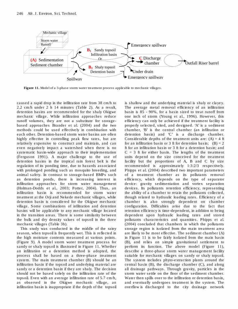
caused a rapid drop in the infiltration rate from 38 cm/h to 2.2 cm/h under 2 h 14 minutes (Table 2). As a result, detention basins are recommended for the shaly Okigwe mechanic village. While infiltration approaches reduce runoff volumes, they are not a substitute for storage-based approaches Brander et al. (2004) and the two methods could be used effectively in combination with each other. Detention-based storm water basins are often highly effective in controlling peak flow rates, but are relatively expensive to construct and maintain, and can even negatively impact a watershed when there is no systematic basin-wide approach to their implementation (Ferguson 1991). A major challenge to the use of detention basins in the tropical rain forest belt is the regulation of its ponding time, due to hazards associated with prolonged ponding such as mosquito breeding, and animal safety. In contrast to storage-based BMPs such as detention ponds, there is increasing interest in infiltration approaches for storm water management (Holman-Dodds et al., 2003; Potter, 2004). Thus, an infiltration basin is recommended for storm water treatment at the Orji and Nekede mechanic villages, while detention basin is considered for the Okigwe mechanic village. Some combinations of infiltration and detention basins will be applicable to any mechanic village located in the transition areas. There is some similarity between the bulk and dry density values of topsoil in the three mechanic villages (Table 3b).
This study was conducted in the middle of the rainy season, when topsoil is frequently wet. This is reflected in the high moisture contents measured at various points. (Figure 9). A model storm water treatment process for sandy or shaly topsoil is illustrated in Figure 11. Whether an infiltration or a detention method is adopted, the process shall be based on a three-phase treatment system. The main treatment chamber (B) should be an infiltration basin if the topsoil and underlying material are sandy or a detention basin if they are shaly. The decision should not be based solely on the infiltration rate of the topsoil. Even with an average infiltration rate of 5.7 cm/h, as observed in the Okigwe mechanic village, an infiltration basin is inappropriate if the depth of the topsoil
is shallow and the underlying material is shaly or clayey. The average metal removal efficiency of an infiltration basin is 85 - 90%, for a basin sized to treat runoff from one inch of storm (Young et al., 1996). However, this efficiency can only be achieved if the treatment facility is properly selected, sited, and designed. ‘A’ is a sediment chamber, ‘B’ is the central chamber (an infiltration or detention basin) and ‘C’ is a discharge chamber. Considerable depths of the treatment units are: (A) = 4 ft for an infiltration basin or 3 ft for detention basin; (B) = 2 ft for an infiltration basin or 3 ft for a detention basin; and C = 3 ft for either basin. The lengths of the treatment units depend on the size conceived for the treatment facility but the proportions of A, B and C by size recommended is approximately 1:3:2/3 respectively. Phipps et al. (2004) described two important parameters of a treatment chamber as its pollutants removal efficiency, which depends on the type of separator device: gravity sedimentation and vortex separation devices. Its pollutants retention efficiency, representing the ability of a chamber to retain the pollutants collected, though related to hydraulic loading rates. Efficiency of a chamber is also strongly dependent on chamber configuration. Difficulties arise due to the fact that retention efficiency is time-dependent, in addition to being dependent upon hydraulic loading rates and stored pollutants characteristics and quantities. Phipps et al. (2004) concluded that chambers in which the pollutants storage region is isolated from the main treatment area are likely to be most effective. The sediment chamber (A) in Figure 11 is to be fairly isolated from the main basin (B), and relies on simple gravitational settlement to perform its function. The above model (Figure 11), describe a three-phase storm water management facility suitable for mechanic villages on sandy or shaly topsoil. The system includes phyto-extraction plants around the central basin (B), the discharge chamber (C), and along all drainage pathways. Through gravity, particles in the storm water settle on the floor of the sediment chamber. Water then spills over to the infiltration or detention basin, and eventually undergoes treatment in the system. The overflow is discharged to the city drainage network

through a filter diaphragm at much reduced speed.
The floor and walls of the sediment chamber are to be lined with smooth porous concrete. The capacity ratio of the sediment chamber to the central basin is recommended at 3:1, so that sediment chamber can accommodate a large volume of material transported in the storm water. A large volume is expected due to the barrenness of drainage area in the mechanic villages, amounting to a total exposure of surface soil to runoff. The sediment basin will require regular cleaning, particularly during the heavy rain period (July - September). Sand recovered from the sediment chamber can be used as building material. To reduce the amount of sand reaching the sediment chamber, riprap will be laid along the drainage pathway to the storm water facility. To limit the rate of mosquito breeding in the basin, as well as satisfying other safety issues, ponding time of the infiltration basin will not exceed 48 h after a rain. The treatment facility will be protected from human and animal interference with a wire fence. There will be a secured entrance for routine servicing, particularly the removal of sediments. Phytoremediation of topsoil in mechanic villages Local phyto-remediation plants will be planted in the central basin to remove the toxic heavy metal contaminants. Gilbert and Alberto (2008), Remon et al. (2005) and others have discussed the principles of phyto-remediation for an effective site restoration. According to Remon et al. (2005), indigenous plants species predomi-nant in an area is usually most preferred. This is because indigenous species can easily adapt to relocations and cope with local conditions in a phyto-restoration program. Fakayode and Onianwa (2002) obtained strong correlation between heavy metal concentration in soil and in local guinea grass (Panicum maximum) around Ikeja industrial estate Nigeria. Their result shows significant correlation with respect to Cd (0.83), Mn (0.94), Ni (0.90), and Pb (0.73). This result suggests that Guinea grass could be used for phyto-remediation in mechanic villages. The phyto-remediation technique modifies plants to take up the poison in their roots and transport it to the leaves for easy harvesting. At saturation, the plants and or the leaves can be harvested and incinerated or dried and shrunk to store (Goudarzi, 2006). The choice of phyto-remediation species shall be based primarily on the pollutants of greater concern which consists of Pb, Cu, and Mn. Extended producer responsibility (EPR) for recycling or disposal of used automobile oil We recommended that proprietors of mechanic villages, and the union of mechanics, may reach an understanding
Nwachukwu et al. 247 with major petroleum marketers over the recycling or disposal of used engine and transmission oil from mechanic villages. This issue calls for extended producer responsibility (EPR): a concept wherein the gas stations representing the producers decide how best to manage the used oil. For example, the marketers could be obliged to visit mechanic villages on regular basis to collect the waste oil, then dispose of it properly. The mechanics are in turn obliged to employ and maintain a waste oil storage facility in their workshops, for example a pair of plastic barrels. Lindquist (2000) explained that “EPR is implemented through administrative, economic and informative instruments. The composition of these instruments determines the precise form of the EPR. The principle of economic and physical responsibility should be put in practice, but initially only for a limited number of materials and for materials that are recyclable and continuously marketable” Used motor oil is recyclable and also marketable, and the administrative, the economic and the informative tools are affordable and available at this time. Were governments enforcing such a regulation; the practice of spilling waste oil on the ground in mechanic villages would be dramatically reduced. The present lack of environmental regulations or enforcement is regrettable. Finally, mechanics deserve continuous training on occupational waste management and the grave consequences of poor management. Installation of groundwater monitoring wells near mechanic villages Another essential component of the waste management plan is installing observation wells near the mechanic villages. Shallow wells (≤ 70 m deep) shall be placed near mechanic villages suspected to be at risk of pollution due to poor waste management. Such wells must be continuously monitored by analysing the water. Observation wells may be installed ≤ 500 m away from each mechanic village, in the direction of drainage. The selected distance of each observation well from its respective mechanic village will depend on the proximity of water wells and human residence. Conclusion The results from this study indicate that soil contami-nation in mechanic villages can be controlled, and the presently contaminated soil can be restored by using three-phase storm water treatment facilities. Infiltration and detention basins are relatively cost-effective because they require little infrastructure to function. They can be made even more cost- effective if a single basin can treat a large drainage area. The major costs involved are construction, land acquisition and usage costs. Maintenance costs vary depending on the extent of

248 Afr. J. Environ. Sci. Technol. landscaping and frequency of sediment removal. In the U.S., the total construction cost of a 0.25-acre basin is about $2 (adjusted for inflation) per ft
3
of storage (SWRPC, 1991). The overall cost would be much less in many developing countries due to the relatively low costs of land and labour. Infiltration basins typically occupy a small land area about 2 to 3% of the site draining to them. The smoke and dust wastes generated in mechanic villages may form aerosols, contributing to the acidity of rainwater and raising the pH of topsoil over a large area. Hence, the heavy metal particles or contaminants contained in runoff and storm water must be removed immediately, before the water joins the urban waterways.
Many developing countries lack guidelines and enforcement for the handling and disposal of occupational wastes arising from auto mechanics activity. Many have not even established a standard code of practice for mechanics. It is a matter of record that poor management of occupational waste in mechanic villages is a cause of soil and water pollution, with negative consequences for ecology, public health, and the overall quality of the environment. This paper has demonstrated an adequate and affordable investigation procedure that will be useful in the design of a suitable waste management plan for environmentally friendly mechanic villages. The same recommendations may be applied to other regions with similar geology and soil characteristics. The three mechanic villages investigated in this study are very poorly developed. The Orji and Nekede mechanic villages in particular are not properly situated. Environmentally friendly mechanic villages provided with good storm water treatment facilities and waste disposal system, in addition to tarred roads, concrete floor workshops, good drainage system, and environmental education to the mechanics are essential to the improvement of environmental quality and public health in the basin. ACKNOWLEDGEMENTS
We thank GEOPROBE International Consultants Limited Owerri for instrumentation and logistics, and the Federal University of Technology Owerri Nigeria for an initial research grant. Special thanks go to the following staff of GEOPROBE: Chinedu Ohuawunwa (geophysicist), Paul Brown (geologist), Onyebuchi Nwozuzu (geologist), Anyika L, (FUTO analytical chemist) and Maureen I. Amadi (geologist). Interns: Chimamkpa Nwachukwu, Okechukwu Onyejekwe and Lambert C. Okoro participated in the field work. REFERENCES Abdulahi IB (2008). Budgetary allocations and selected sectors’ contribution to economic development in Nigeria; Pak. J. Social Sci. 5 (9): 894-898.
Adie GU, Osibanjo O (2009). Assessment of soil-pollution by slag from
an automobile battery manufacturing plant in Nigeria; Afr. J. Environ. Sci. Technol. 3(9): 239-250.
Ajayi AB, Dosunmu OO (2002). Environmental hazards of importing used vehicles into Nigeria; Procedings of international symposium on environmental pollution control and waste management Tunis EPCOWM p. 521-532.
Anthony NJ, Lagowski JJ, Johnson C (2003). Analysis of Heavy Metals in Remediate Soil Using an Atomic Absorption Spectrometer (AAS); Wekh summer scholar program, University of Texas.
ASTM D3385 (2009). Standard test methods for infiltration rate of soils in the field using double-ring infiltrometer was used. ASTM D3385 (Geotech. Eng. Standards): DOI: 10.1520/D3385-09.
Brander KE, Owen KE, Potter KW (2004). Modeled impacts of development type on runoff volume and infiltration performance. J. Am. Water Resour. Assoc. 404: 961-969.
Dobrin MB, Savit CH (1988). Introduction to geophysical prospecting 4th Edn. McGraw-Hills NY.
Dioka CE, Orisakwe OE, Adeniyi FA, Meludu SC (2004). Liver and Renal Function Tests in Artisans Occupationally Exposed to Lead in Mechanic Village in Nnewi, Nig. Int. J. Environ. Res. Public Health 1(1): 21-25.
Enikanselu P (2008). Geophysical Seismic Refraction and Uphole Survey Analysis of Weathered Layer Characteristics in the “Mono” Field, North Western Niger Delta, Nigeria. Pacific J. Sci. Technol. 539(9): 2.
Fedler C (2009). Infiltration requirements for surface application OSSF system; Civil and Environmental Engineering Texas Technical University.
Ferguson BK (1991). The failure of detention and the future of stormwater design.” Landscape Architecture 81(12): 76-79.
Fakayode SO, Onianwa PC (2002). Heavy metal contamination of soil, and bioaccumulation in Guineagrass (Panicum maximum) around Ikeja Industrial Estate, Lagos, Nigeria; Environ. Geol. 43: 145-150.
Falk RL, Ward WC (1957). Brazo River Bar: Study of the significance of grain size parameters. J. Sedimentary Petrol. 5: 3-26.
Galli J (1992). Analysis of Urban BMP Performance and Longevity in Prince George's County Maryland: Metropolitan Washington Council
of Governments, Wash., DC. Gilbert S, Alberto P (2008). Phytoremediation potentials of lead-
contaminated soil, using Tropical grasses; Florida Scientist 71(1): 1-6, USDA- Agric. Res. Station.
Goudarzi S (2006). Plant extracts arsenic from polluted soil; Environment Life Science, J. Proc. Nat. Acad. Sci.
Göbel P, Stubbe H, Weinert M, Zimmermann J, Fach S, Dierkes C, Kories H, Messe J, Mertsch V, Wolfgang FG, Wilhelm GC (2004). Near-natural stormwater management and its effects on the water budget and groundwater surface in urban areas taking, account of the hydrogeological conditions doi:10.1016/j.jhydrol.
Haswell SJ (1991). Atomic Absorption Spectrometry: Theory, Design and Applications. Elsevier, Amsterdam.
Hilding K (1996). Longevity of infiltration basins assessed in Puget Sound. Watershed Prot. Tech. 1(3): 124-125.
Holman-Dodds JK, Bradley AA, Potter KW (2003). “Evaluation of hydrologic benefits of infiltration based urban storm water management.” J. Am. Water Resour. Assoc. 391: 205-215.
Igbozuruike CWI, Opara-Nadi AO, Okorie IK (2009). Concentrations of Heavy Metals in Soil and Cassava Plant on Sewage Sludge Dump; UC Davis, the Proceedings of the International Plant Nutrition Colloquium XVI, Int. Plant Nutri. Colloquium.
Ipeaiyeda AR, Dawodu M (2008). Heavy metals contamination of topsoil and dispersion in the vicinities of reclaimed auto-repair workshops in Iwo Nigeria Bull Chem. Soc. Ethiopia 22(3): 339-348.
Ivanova E, Stoimenova M, Gentcheva G (1994). Flame AAS determination of Cd, As, and Ti in soil and sediments after their simultaneous carbodithiate extraction. Frensenius J. Analy. Chem. Springer Verlag 384: 317-319.
Iwegbue CM (2007). Metal fractionation in soil profiles at automobile mechanic waste dumps around Portharcourt. Waste Manage. Res.
25(6): 585-593. Liu C, Zhang Y, Zhang F, Zhang S, Yin M, Ye H, Hou H, Dong H, Zhang
M, Jiang J, Pei L (2007). Assessing pollutions of soil and plant by
municipal waste dump. Preview By: Environ. Geol. 52(4): 641-651. Lindquist T (2000). Extended Producer Responsibility in Cleaner
Production. Policy Principle to Promote Environmental Improvements of Product Systems: Doctoral dissertation; Lund Univ. Retrieved 11/12/09 at http://www.lub.lu.se/luft/diss/tec355.pdf.
Mangangka IR (2008). The Decline of Soil Infiltration Capacity Due To High Elevation Groundwater; Civil Engineering Dimension 10(1).
Mico C, Recatala L, Peris M, Sanchez J (2007). A comparison of two digestion methods for the analysis of heavy metals by flame atomic absorption spectroscopy; Article 19(1).
Novak JM, Watts DW (2004). Increasing the Phosphorus Sorption Capacity of South-eastern Coastal Plain Soils Using Water Treatment Residuals; Soil Sci. 169(3): 206-214.
Nwachukwu MA (2003). Determination of weathered layer by Up-hole shooting technique within Owerri, SE Nigeria: Global J. Geol. Sci. 2(1).
Nwachukwu MA (1993). Application of Electrical Resistivity and Seismic refraction surveys for groundwater exploration in factored areas case study of Ogbunike - Umunya areas. Int. Assoc. Hydro-geologists. xxivth Cong, Oslo, Greece.
Nwachukwu MA (2004). Alluvial mining and the sedimentary cycle- a stream sediment analysis review, Am. Society for Mining, Metallurgy, and Exploration; Vol. 316 Transactions 2004.
Nwachukwu MA, Feng H, Alinnor J (2010). Assessment of heavy metal pollution in soil and their implications within and around mechanic villages; Int. J. Environ. Sci. Tech. 7(2): 347-358.
Obrompta C, Kardos J (2007). Review of Urban Stormwater Quality Models: Deterministic, Stochastic, and Hybrid Approaches1 J. Am. Water Resour. Assoc. 43(6): 1508-1523.
Onyeagocha AC (1980). Petrography and Depositional Environment of the Benin Formation, Nigeria. J. Min. Geol. 17: 147-151.
Onianwa PC, Jaiyeola OM, Egekenze RN (2002). Heavy metal contamination of topsoil in the vicinities of auto-repair workshops, gas stations and motor parks in a Nigerian city Toxicol. Environ. Chem. 84 (1-4): 33-39.
Nwachukwu et al. 249 Paulo CG, Mauricio PF, Fontes Aderbal GS, Eduardo SM, André RN
(2001). Selectivity Sequence and Competitive Adsorption of Heavy Metals by Brazilian Soils; Soil Sci. Soc. Am. J. 65: 1115-1121.
Pennsylvania Storm water Best Management Practices (BMP) Manual (2006). Chap. 6: Structural pp. 151-257.
Perez-Pedini C, Limbrunner JF, Vogel RM (2005). Optimal Location of Infiltration-Based Best Management Practices for Storm Water Management; J. Water Resour. Planning Manage asce /443.
Phipps DA, Alkhaddar RM, Dodd J, Faram MG, Pamela J, Deahl PE (2004). Evaluation of different configurations of storm water treatment chamber; StormCon: 3rd North Am. Surface Water Q. Conf. Exposition.
Pitt R, Clark SE (2008). Integrated Storm-Water Management for Watershed Sustainability J. 134(5): 548-555, September/October 2008.
Potter KW (2004). Managing stormwater at the source: Transactions of the Wisconsin, Acad. Sci. Art Lett. 90: 67-73.
Remon E, Bouchardon JL, Cornier B, Guy B, Leclerc JC, Faure O (2005). Soil characteristics, heavy metal availability and vegetation recovery at a former metallurgical landfill: Implications in risk assessment and site restoration; Environ. Poll. 137(2): 316-323.
Southeastern Wisconsin Regional Planning Commission (SWRPC) (1991). Costs of urban nonpoint source water pollution control measures. Waukesha.
Telford WM, Geldart LP, Sheriff RE (1990). Applied Geophysics 2nd Edn. Sci. paperback,
Yang H, Rahardjo H, Leong C (2006). Behavior of unsaturated layered soil columns during infiltration; J. Hydrol. Eng. 11(4): 329-337, ASCE 1084-0699.
Young GK, Stein P, Cole T, Kammer F, Graziano FB (1996). Evaluation and Management of Highway Runoff Water Quality; FHWA-PD-96-032. Fed. Highway Admin., Office Environ. Planning.