Embed Size (px)
Citation preview
Integrating Climate Change & Water Supply Planning In Southeast Florida
Updated September 9, 2014
ABOUT THE RCAP IMPLEMENTATION GUIDE DOCUMENT SERIES
This Compact Guidance Document is one in a series of publications designed to assist county and municipal policymakers, administrators and program staff with the nuts and bolts of voluntarily implementing the 110 recommendations contained within the Southeast Florida Regional Climate Change Compact’s 2012 Regional Climate Action Plan. The publication series is produced by the Institute for Sustainable Communities on behalf of the Southeast Florida Regional Climate Change Compact with funding graciously provided by the Kresge Foundation.
The content of Integrating Climate Change & Water Supply Planning in Southeast Florida was developed by staff from Broward County’s Environmental Protection & Growth Management Department and tested in a Regional Climate Action Plan implementation workshop held on April 17, 2014 with 64 participants from across the Southeast Florida region who generously provided their experience, expertise and insights. ISC and the Compact partners gratefully acknowledge their participation.
For more on the Southeast Florida Regional Climate Change Compact: www.southeastfloridaclimatecompact.org
For more on the Institute for Sustainable Communities: www.iscvt.org
Table of Contents I. Model Background Narrative – pg. 3
II. Available Maps, Projections and Technical Tools for Use in IntegratingClimate Change into Water Supply Planning – pg. 7
III. Model Goals, Objectives and Policies for Use in ComprehensivePlanning Documents– pg. 14
IV. Linking Strategic Goals, Objectives and Policies to LocalComprehensive Planning – pg. 17
V. Comprehensive Planning Statutory Provisions Useful inConsideration of Climate Impacts – pg. 20
VI. Other Reference Materials – pg. 23
INTEGRATING CLIMATE CHANGE & WATER SUPPLY PLANNING 2
Model Background Narrative This section contains model narrative that can be modified for inclusion in the appropriate sections of your comp plan and associated 10-year water supply work plan
Southeast Florida is widely considered one of the most vulnerable regions to the impacts of climate change and sea level rise as a result of several unique geographic characteristics which include low land elevations, flat topography, a porous geology, and dense coastal development. In combination, climate change and sea level rise are expected to present significant challenges relating to water resource planning, management and infrastructure for communities throughout the region, which include Broward, Miami-Dade, Monroe, and Palm Beach Counties. These communities have agreed to partner in regionally-coordinated climate mitigation and adaptation strategies as part of the Southeast Florida Regional Climate Change Compact (Compact) and have adopted a Regional Climate Action Plan (RCAP) which highlights “Water Supply, Management, and Infrastructure” as a primary focal area.
Investigations and evaluations conducted at the national, regional, and local levels have reinforced the need to plan for the predicted impacts of more frequent and severe drought, increases in tidal and storm-related flooding, and the loss of coastal wellfield capacity due to saltwater contamination. In the absence of proactive planning, these impacts will present liabilities for coastal and inland communities with implications for urban water supplies, water and wastewater infrastructure, and both regional and local drainage/flood control systems. Investments in water supply planning and infrastructure that account for these predicted trends will improve the resilience of our communities, provide public health benefits, and reduce the potential for economic losses.
It is imperative that local governments and water utilities begin to formalize the integration of water supply and climate change considerations as part of coordinated planning efforts, including updates to local government and water utility 10-year Water Supply Facility Work Plan and other relevant documents, as well as, enhancements to the Goals, Objectives and Policies (GOPs) of their local Comprehensive Plan. Key considerations for communities within the four-County Compact planning area include: 1) sea level rise, 2) saltwater intrusion, 3) extreme weather, and 4) infrastructure investments to support diversification and sustainability of water supply sources, and adaptive stormwater and wastewater systems.
Sea Level Rise
Sea level rise has significant implications for water management and water supply planning in southeast Florida, the rate of which is accelerating. During the previous century, the global rate of sea level rise averaged approximately 1.6 mm per year. The rate of rise increased to an average of 1.7 mm per year during the second half of the last century, followed by a more significant increase to 3.3 mm per year measured during the last decade. This trend of rising sea level is reinforced by local tide data which documents an increase in regional sea level of about 9 inches during the last 100 years. While there continues to be uncertainty about the overall extent of sea level rise that might be realized in the coming century, the Third National Climate
INTEGRATING CLIMATE CHANGE & WATER SUPPLY PLANNING 3
Assessment (NCA) presents a probable range of 1 to 4 feet by 2100. In southeast Florida, partner counties in the Southeast Florida Regional Climate Change Compact have collectively agreed to use modified guidance developed by the U.S. Army Corps of Engineers (USACE) and a planning scenario of 9 to 24 inches additional rise by 2060, consistent with projections presented in the 2014 NCA. This unified sea level rise projection has been formally adopted by Broward, Miami-Dade, Monroe, and Palm Beach Counties and is now being used to inform planning processes and project design throughout the region. As the impacts of historic sea level rise are already being realized and acceleration of the rate of rise is expected to compound local impacts and vulnerabilities, it is prudent that planning processes begin to formally reflect consideration of sea level rise as a future condition with recognized implications for near-term and longer-term planning decisions.
Sea level rise produces varied challenges with respect to water resources sustainability, water management, and water/wastewater facilities and infrastructure. Impacts include saltwater contamination of coastal wellfields, infiltration of groundwater with elevated chloride levels into wastewater collection systems, impairing normal operations and maintenance as well as limiting opportunities for beneficial use of reclaimed water as an alternative water supply. Water management systems are also at risk with systems constrained by rising groundwater and tailwater elevations, which reduce soil storage and discharge capacity, with increased potential for both inland and coastal flooding and less opportunity for long-term storage of stormwater for beneficial reuse.
These realities necessitate consideration of plans and investments that might be needed to compensate for loss of existing water supplies through relocation of wellfields and the development of alternative water supplies while also seeking opportunities to expand regional water storage opportunities. These investments and considerations are in addition to concurrency planning for population growth and water demands that are typical requirements for water supply planning.
Saltwater Intrusion
Along the coast of southeast Florida, and several miles inland, groundwater supplies and potable wells are vulnerable to saltwater contamination. The Biscayne Aquifer which serves as the region’s primary water supply is a shallow, surficial aquifer characterized by limestone karst geology which is highly porous, and transmissive. As a result, coastal saltwater intrusion of the aquifer has begun to restrict coastal water supplies and necessitated the development of western wellfields, changes in water management operations, development of alternative water supplies, and investments in reclaimed water projects to enhance aquifer recharge. At the toe of the front, chloride concentrations exceed the drinking water standard of 250 mg/l and thus restrict and/or require abandonment of wells located east of the saltwater intrusion line.
In the 2000 Lower East Coast (LEC) Plan, saltwater intrusion was identified as a significant concern for 15 coastal utilities, which were asked to identify potential locations for new wellfields further inland. Following the adoption of the plan, the South Florida Water Management District (SFWMD) planning and regulatory programs provided support to these utilities considered most at risk. The 2005–2006 Lower East Coast Water Supply Plan Update
INTEGRATING CLIMATE CHANGE & WATER SUPPLY PLANNING 4
(2005–2006 LEC Plan Update; SFWMD 2007) included specific alternative water supply projects for each of those utilities. Some of the utilities at risk had already begun planning either new wellfield sites or alternative source development.
During 2007 and extending into mid-2008, South Florida experienced an extended period of dry weather. Water levels declined throughout the region, creating concerns for accelerated saltwater intrusion, particularly in the areas of large water supply withdrawals at public water supply wellfields located in close proximity to the coastline. As a result, SFWMD updated its analysis of utilities facing saltwater intrusion. Utilities were classified as “at risk” if they either did not have a western wellfield, an alternative source of water, or the ability to meet their needs through interconnection with other utilities. Additionally, other utilities were designated as “of concern” if they operated wellfields near the saltwater interface, but also had a western wellfield, or had developed an alternative source that was not threatened by saltwater intrusion. Most of the utilities at risk have continued to take steps to diversify their sources to help reduce their vulnerability to saltwater intrusion. Additionally, the SFWMD anticipates reformulating its analysis of utilities at risk and utilities of concern prior to the next update of the LEC plan.
While impacts and planning efforts have historically focused on the most at risk utilities and wellfields the accelerated rate of sea level rise and advancements in modeling and planning tools provide support and justification for a more holistic review of anticipated trends and necessary responses on both a local and regional scale.
Technical assessments have further identified changes in land use, reduced water flows to the Everglades, wellfield operations, and sea level rise as contributing factors to the historical movement and current location of the saltwater front within the productive layer of the aquifer.
Hydrologic modeling has revealed that sea level rise when combined with coastal wellfield pumping, has accelerated the movement of the front, doubling the rate at which the front has progressed inland over the last several decades at certain locations. It is expected that sea level rise will constitute an increasingly significant influence on the rate of saltwater migration during the decades to come and that critical wellfield capacity will be lost with an additional 2 foot increase in sea level, the extent of which will vary along the coast. Conditions will be further influenced by temporal hydrologic conditions and responses in water management operations. It is therefore prudent for water utilities throughout the region (both inland and coastal) to consider adaptation plans that might include wellfield relocation or expansion of western wellfields as part of planned efforts to meet shared regional water demands. Continuation of groundwater monitoring and modeling efforts will be critical to predicting the movement of the front under sea level rise scenarios anticipated over the next several decades and adaptation efforts should continue to be refined in accordance with predicted and realized trends.
Regional and local data will be important in informing decision-making. The mapping of the saltwater intrusion front is supported by local governments throughout the region, the United States Geologic Survey (USGS), and the SFWMD. The next regional update of the saltwater interface is anticipated in 2014.
INTEGRATING CLIMATE CHANGE & WATER SUPPLY PLANNING 5
Concomitant with rising sea levels, increased salt concentrations in groundwater infiltrating into coastal sanitary wastewater collection systems will impact cost-effective reclaimed water opportunities that could otherwise have been used to meet irrigation demands or recharge. Related infrastructure impacts from sea level rise include accelerated physical degradation of the built environment, increased Operations and Maintenance (O&M) and engineering design costs to support long-term public water and wastewater capital projects. In addition, significant and strategic monitoring and financial programming will be needed to support adaptation strategies. These options might include lining or armoring the sanitary sewer collection systems, redesigning or relocating collection systems, and building additional water quality treatment capacity such as membrane filtration.
Extreme Weather Events
As extreme events increase in frequency and severity, comprehensive planning should consider impacts and risks associated with drought, water shortages and reduced groundwater tables, all of which can hasten saltwater intrusion and exacerbate water supply impacts. Extreme heat events are likely to increase potable water demand. Conversely, more intense rainfall will cause flooding, increased runoff, impacts to the natural systems and provide less recharge potential for wellfields. Integrated water resources management strategies will help to mitigate for these impacts, particularly those projects that can serve to provide additional long-term storage of stormwater runoff, and redistribution of excess rainfall during dry periods and drought. Regional surface water reservoirs and below ground Aquifer Storage and Recovery (ASR) systems are potentially viable alternative water supply projects and climate adaptation strategies.
Infrastructure Development
With increasing climate change there is a need to diversify water supply sources, treatment technologies, and to provide adaptive stormwater and wastewater infrastructure design criteria to ensure long-term sustainability of key facilities. Conversely, alternative water treatment technologies generally have a high energy demand and carbon footprint that can exacerbate climate change impacts. Strategic infrastructure planning should incorporate these constraints and work within with the Goals, Policies and Objectives of the Comprehensive Planning processes and water supply facility work plans to provide for long-term sustainable and balanced approach for future development.
Increases in groundwater elevations, in both direct and indirect response to sea level will challenge the function of drainage systems and is expected to exacerbate flooding for even mild storm events. Conditions will be more severe under extreme rainfall events, potentially increasing damage to low-lying utility infrastructure and contributing to prolonged surface water flooding. Planning for the combined influences of storm events, high tides and sea level rise on drainage system functions and other public infrastructure is a critical need as is the assessment of viable water supplies and impacts to the natural systems from prolonged droughts.
Options that provide for a diversification of water projects and protection of resources will be fundamental and may include; regional water storage such as the C-51 Reservoir, ASR, the
INTEGRATING CLIMATE CHANGE & WATER SUPPLY PLANNING 6
development and use of highly-treated wastewater (reverse osmosis) for recharge and/or hydrodynamic barriers, wastewater reuse for irrigation to reduce well pumping for systems where potable and shallow groundwater serve as the source of irrigation, the relocation and/or regionalization of wellfields and treatment facilities away from coastal and low-lying areas, and enhancing operational flexibility.
Finally, the support of regional water conservation efforts is a proven strategy for extending the timeline to develop more expensive alternative water supply technologies and should be a prominent objective and dedicated effort to support water resource protections under the threat of sea level rise and climate change.
INTEGRATING CLIMATE CHANGE & WATER SUPPLY PLANNING 7
Available Maps, Projections and other Technical Tools for Use in Integrating Climate Change into Water Supply Planning
This section contains graphics for use in your documents and links to more information to assist you with your process.
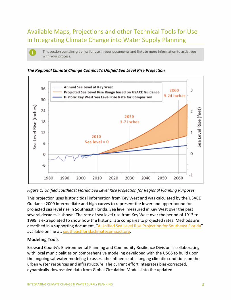
The Regional Climate Change Compact’s Unified Sea Level Rise Projection
Figure 1: Unified Southeast Florida Sea Level Rise Projection for Regional Planning Purposes
This projection uses historic tidal information from Key West and was calculated by the USACE Guidance 2009 intermediate and high curves to represent the lower and upper bound for projected sea level rise in Southeast Florida. Sea level measured in Key West over the past several decades is shown. The rate of sea level rise from Key West over the period of 1913 to 1999 is extrapolated to show how the historic rate compares to projected rates. Methods are described in a supporting document, “A Unified Sea Level Rise Projection for Southeast Florida” available online at: southeastfloridaclimatecompact.org.
Modeling Tools
Broward County’s Environmental Planning and Community Resilience Division is collaborating with local municipalities on comprehensive modeling developed with the USGS to build upon the ongoing saltwater modeling to assess the influence of changing climatic conditions on the urban water resources and infrastructure. The current effort integrates bias-corrected, dynamically-downscaled data from Global Circulation Models into the updated
INTEGRATING CLIMATE CHANGE & WATER SUPPLY PLANNING 8
surface/groundwater model that can be used for predictions county-wide. The existing 3D MODFLOW model includes a new Urban Runoff Package (URO) that offers enhanced capabilities within focused areas to test scenarios intended to mitigate climate change impacts on groundwater elevations, flood management operations, and water quality. The County continues to seek ways to enhance communication of model results to decision makers and the public, by advancing the use of 3D visualization tools to aid in understanding.
Miami-Dade County Water and Sewer Department (WASD) and the Department of Regulatory and Economic Resources (RER) are working with USGS to develop a series of numerical models/tools to evaluate the surface-water and groundwater flows and exchanges. This allows the County to evaluate the potential effect of changing wellfield operations and/or canal management on groundwater levels and surface water discharges and to evaluate the effect increased sea levels will have on the position of the saltwater interface. A useful component of this modeling is the dynamic surface-water routing (SWR1) process for MODFLOW-2005 that is expected to greatly improve the ability to simulate surface water/groundwater interactions in south Florida.
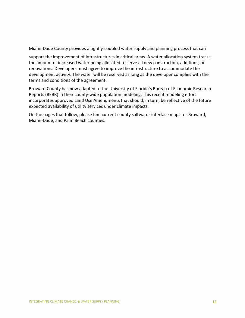
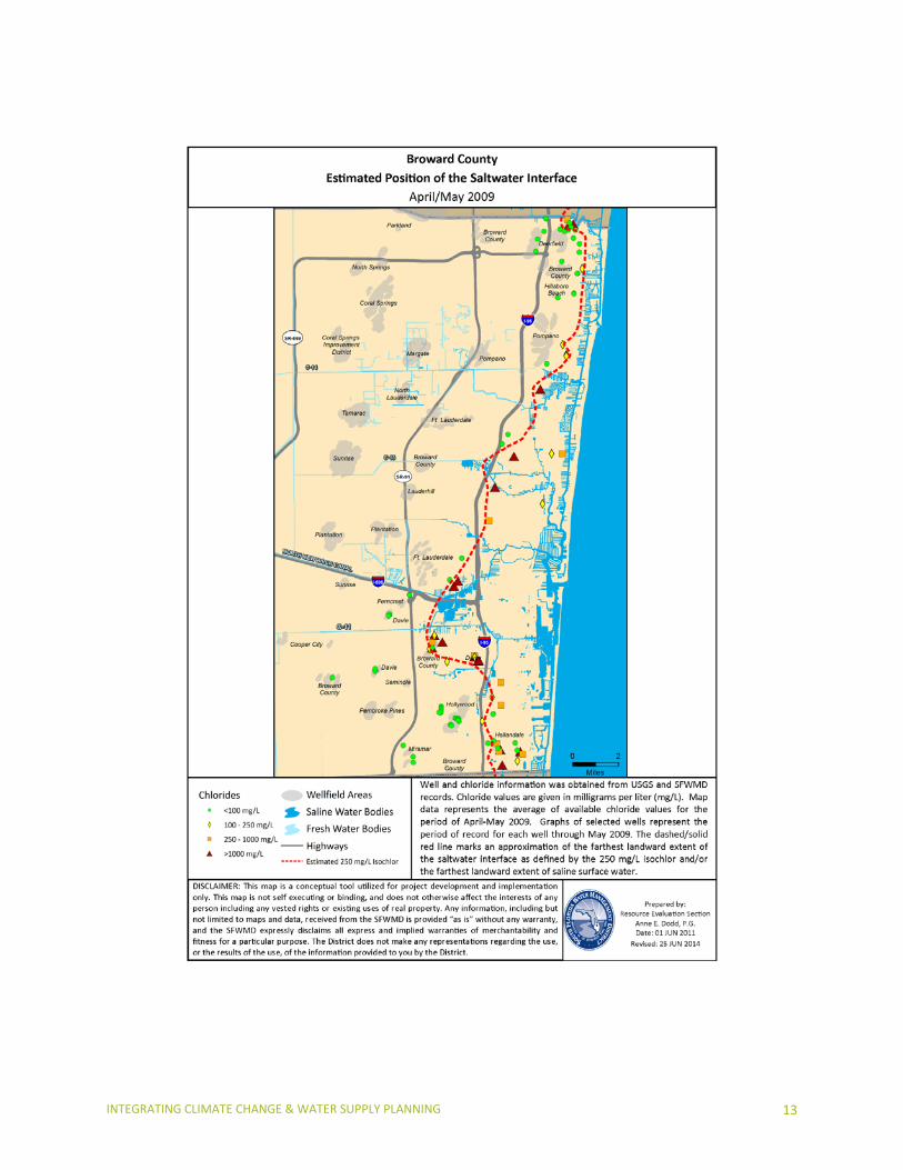
The SFWMD tracks the USGS’s network of salinity monitoring wells in Palm Beach and Broward Counties to determine areas of potential concern, particularly with regard to saltwater intrusion. The current Saltwater Interface Maps are from 2009 but are expected to be updated later in 2014. The SFWMD intends to compile chloride data every 3 to 5 years from its salinity monitoring well network and prepare maps estimating the position of the saltwater interface and allow comparison over time. The Broward and Palm Beach County maps with the well coverages are available at:
♦ http://www.sfwmd.gov/portal/page/portal/xrepository/sfwmd_repository_pdf/palm_beach_isochlor_apr-may_2009opt.pdf
♦ http://www.sfwmd.gov/portal/page/portal/xrepository/sfwmd_repository_pdf/broward_isochlor_apr-may_2009opt.pdf
GIS shape files are available via the GIS Catalog:
♦ http://my.sfwmd.gov/gisapps/sfwmdxwebdc/dataview.asp
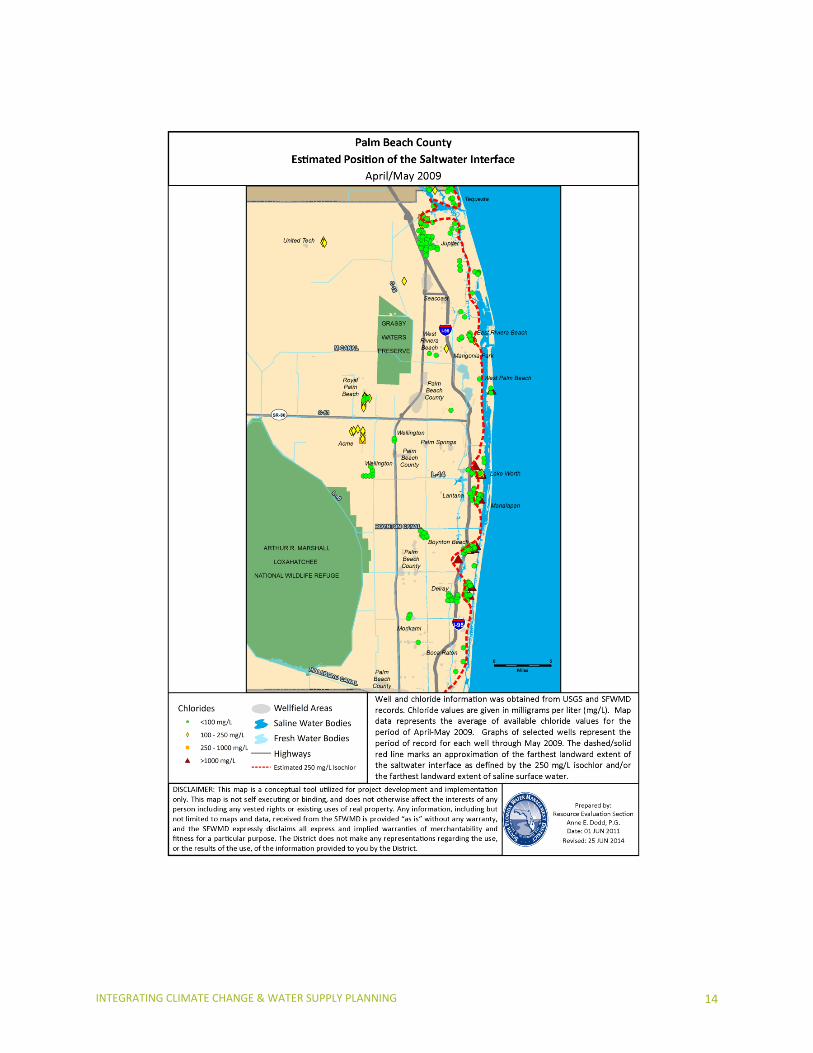
The USGS updates the Miami-Dade map and the most recent map can be found at:
♦ http://sofia.usgs.gov/publications/circular/1275/saltintrusion.html
Broward County’s Saltwater Intrusion Models use the USGS’s SEAWAT to track density-dependent flow and transport of chlorides due to the intrusion of saline water. The outcome of this County-wide modeling effort will allow for quantification of various anthropogenic stresses (i.e., municipal groundwater withdrawals, changing canal water elevations and land-use changes) and natural stresses (i.e., drought conditions and sea level rise) to evaluate the greatest influences on the movement of the saltwater front. This will provide a useful tool for future water management and resource planning.
INTEGRATING CLIMATE CHANGE & WATER SUPPLY PLANNING 9
Tracking Impacts to Water Supplies
The SFWMD evaluates the extent to which salt water intrusion is impacting availability of potable water supplies. Those “Utilities of Concern” or “Utilities at Risk” are tracked as part of the regulatory compliance and/or in accordance to limiting conditions of the consumptive use permitting. A notable conclusion from the last report was related to the utilities’ ability to support water supplies during prolonged drought conditions by using interconnects and other contingency planning. While contingency planning should occur at both the local utility and regional levels, in fact, very few of the utilities have formal written plans for conditions that affect their water supply source. See below for the documents produced after the historic drought of 2007-2008.
Lower East Coast Utilities of Concerns, 2007
♦ http://www.sfwmd.gov/portal/page/portal/xrepository/sfwmd_repository_pdf/utilitiesofconcern_uec-lec-lwc-losa_052407.pdf
Water Shortage Demand Reduction Report, 2009
♦ http://www.sfwmd.gov/portal/page/portal/xrepository/sfwmd_repository_pdf/water_demand_reduction_report_final.pdf
INTEGRATING CLIMATE CHANGE & WATER SUPPLY PLANNING 10
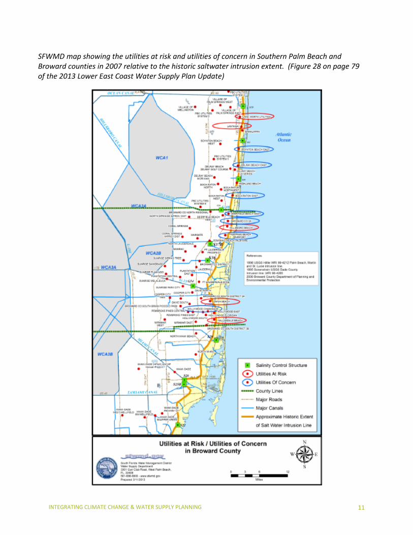
SFWMD map showing the utilities at risk and utilities of concern in Southern Palm Beach and Broward counties in 2007 relative to the historic saltwater intrusion extent. (Figure 28 on page 79 of the 2013 Lower East Coast Water Supply Plan Update)
INTEGRATING CLIMATE CHANGE & WATER SUPPLY PLANNING 11
Miami-Dade County provides a tightly-coupled water supply and planning process that can
support the improvement of infrastructures in critical areas. A water allocation system tracks the amount of increased water being allocated to serve all new construction, additions, or renovations. Developers must agree to improve the infrastructure to accommodate the development activity. The water will be reserved as long as the developer complies with the terms and conditions of the agreement.
Broward County has now adapted to the University of Florida’s Bureau of Economic Research Reports (BEBR) in their county-wide population modeling. This recent modeling effort incorporates approved Land Use Amendments that should, in turn, be reflective of the future expected availability of utility services under climate impacts.
On the pages that follow, please find current county saltwater interface maps for Broward, Miami-Dade, and Palm Beach counties.
INTEGRATING CLIMATE CHANGE & WATER SUPPLY PLANNING 12
INTEGRATING CLIMATE CHANGE & WATER SUPPLY PLANNING 13
INTEGRATING CLIMATE CHANGE & WATER SUPPLY PLANNING 14
INTEGRATING CLIMATE CHANGE & WATER SUPPLY PLANNING 15
Model Goals, Objectives and Policies for Use in Comprehensive Planning Documents
This section contains model goals, objectives and policies that can be modified for use in your planning documents.
Model Goals:
♦ Achieve a sustainable, climate resilient community by: promoting energy efficiency and greenhouse gas reduction strategies; protecting and adapting public infrastructure, services, natural systems and resources from climate change impacts; and continuing to coordinate and communicate locally and regionally to monitor and address the changing needs and conditions of the community.
♦ Incorporate the best available data and science, into its policy and planning decisions for infrastructure, recognizing the need to periodically update projections to account for new data.
Model Objectives:
♦ Adopt the Southeast Florida Regional Climate Change Compact agreed modified guidance developed by the U.S. Army Corps of Engineers that establishes a planning scenario of 9 to 24 inches additional sea level rise by 2060.
♦ Ensure resiliency of existing and future water resources, water and wastewater infrastructure to the impacts of climate change for the protection of water quality, flood damage and water shortages.
♦ Protect and enhance local and regional resources, optimizing coastal buffers, natural recharge areas and expanded green infrastructure, to create a climate resilient environment.
♦ Improve the climate resiliency through development of adaptation strategies for areas vulnerable to climate change-related impacts.
♦ Mitigate the causes of climate change while providing for more energy efficiency of new and existing public infrastructure.
♦ Create and maintain effective intergovernmental coordination and on-going communicating that supports sustainable water supplies and resource protections while maintaining climate change preparedness.
♦ Ensure adequate planning and coordinated response for emergency preparedness and post-disaster management in the context of climate change.
Model Policies Related to Water Resource Infrastructure:
♦ Assess sea level rise projections presented from National Climate Assessment (NCA) updates as best available data and science and incorporate into policy and planning decisions for infrastructure development and service distributions.
♦ Assess the adequacy of water supply and wastewater facilities and infrastructure to effectively capture, store, treat, and distribute potable water and reclaimed water
INTEGRATING CLIMATE CHANGE & WATER SUPPLY PLANNING 16
under variable climate conditions, including changes in rainfall patterns, sea level rise, and flooding, with potential water quality and quantity impacts.
♦ Identify public water and wastewater infrastructure at risk from sea level rise and other climate change related impacts and provide periodic updated assessments no later than every 5 years.
♦ Coordinate adaptive management implementation strategies for water and wastewater resources that address the potential impacts of climate change on long-term operations.
♦ Develop comprehensive County-wide interconnect maps in cooperation with water and wastewater utilities.
♦ Provide for increased assessments needed for projected water, wastewater and stormwater management as changing land-use patterns occur under the potential impacts of climate change.
♦ Evaluate cost/benefit analysis for implementing adaptive management implementation strategies including: planning, siting, construction, replacement and maintenance of public infrastructure as well as fortification or retrofitting of existing infrastructure.
♦ Enhance the funding potential for adaptive management implementation projects. ♦ Develop, implement and coordinate regional water conservation initiatives in
partnership with utilities as part of long-term water supply planning. ♦ Develop regional water demand projection scenarios that account for potential changes
in (1) population and rates of water consumption; (2) municipal, industrial, and agricultural demands as temperatures increase and drought (seasonal or intra-annual) persists; and (3) water demand for energy generation due to possible changes in fuel sources.
♦ Maintain infiltration and inflow corrective programs to strategically reduce the inflow of groundwater and stormwater into wastewater collection and facilities.
♦ Protect existing wellfields, surface or subsurface storage facilities, control structures, water and wastewater treatment plants and transmission infrastructure from increased coastal flooding, sea level rise, saltwater intrusion, and other potential future climate change impacts, and plan for infrastructure replacement and relocation as needed.
♦ Promote reuse programs that mitigate the potential impacts of saltwater intrusion such as saltwater intrusion barriers.
♦ Promote mandatory reuse zones for irrigation when source water is available. ♦ Incorporating building design specifications that increase resistance to impacts from
more intense storm events.
Model Policies Related to Protection from Climate Impacts and Sea Level Rise:
♦ Support a comprehensive saltwater intrusion monitoring program, together with South Florida Water Management District and USGS that provides measurable movement of the saltwater intrusion.
♦ Assess saltwater intrusion within the Data and Analysis requirements of the 10-Year Water Supply Facility Work Plans to implement the Comprehensive Plan Amendments and Land Use Planning.
INTEGRATING CLIMATE CHANGE & WATER SUPPLY PLANNING 17
♦ Address potential impacts on the coastal aquifer from water quality changes and flooding of coastal and tidally influenced bodies of water that may occur due to more intense storms, higher surface water temperatures, and rising sea levels.
♦ Develop contingency plans to address decreases in water availability in coastal wellfields due to saltwater intrusion.
♦ Seek to designate Adaptation Action Areas, per Chapter 163, F.S., for identifying areas especially vulnerable to sea level rise and develop policies for adaptation.
♦ Improve resilience to coastal and inland flooding, salt water intrusion, and other related impacts of climate change and sea level rise through the Comprehensive Plan Amendments and related Elements, the 10 yr. Water Supply Facility Work Plan, Wastewater Master Plans, Stormwater Master Plans, and other local government related plans.
♦ Protect and enhance recharge of the Biscayne Aquifer by reducing run-off through new construction, modification or retrofit requirements that incorporate porous materials, reducing total impervious area.
♦ Promote and support the expansion of alternative and renewable energy from residential, commercial and municipal properties.
♦ Support local environmental restoration, mitigation and adaptive management initiatives, including those related to Everglades restoration, and coordinate with other state, regional and national strategic planning efforts to improve the resiliency of natural lands and systems to climate variability and change.
♦ Support analysis and mapping capabilities for identifying areas vulnerable to sea level rise, tidal flooding, and other impacts of climate change.
♦ Support analysis for 100-year stormwater elevation projections and develop flood maps for use in stormwater management permitting and other planning processes, which incorporate current and projected conditions for sea level rise.
♦ Collaborate with local, regional, state and federal partner agencies on developing the scientific, technical knowledge and integrated modeling efforts and continuous data collection needed to understand the potential impacts of climate change on the region’s water resources, evaluate various adaptation technologies available.
INTEGRATING CLIMATE CHANGE & WATER SUPPLY PLANNING 18
Linking Strategic Goals, Objectives and Policies to Local Comprehensive Planning
This section demonstrates how to link the model goals, objectives and policies to various sections within your planning documents. Following model narrative for four key issues, the key on page 19 denotes (by number) which common local comp plan sections one may wish to include in climate-related considerations.
Sea Level Rise:
Sea level rise produces varied challenges with the respect to water resources’ sustainability, water management, and water/wastewater facilities and infrastructure. Impacts include salt water contamination of coastal wellfields, infiltration of groundwater with chloride levels into wastewater collection systems, impairing normal operations and maintenance as well as opportunities for beneficial use of reclaimed water as an alternative water supply. Water management systems are also at risk with systems constrained by rising groundwater and tailwater elevations, which reduce soil storage and discharge capacity, with increased potential for both inland and coastal flooding and less opportunity for long-term storage of stormwater for beneficial reuse.
These realities necessitate consideration of plans and investments that may be needed to compensate for loss of existing water supplies through relocation of wellfields and the development of alternative water supplies while also seeking opportunities to expand regional water storage opportunities. These investments and considerations are in addition to concurrency and planning for new water demands associated with population growth that are typical requirements for water supply planning.
Saltwater Intrusion:
It is expected that sea level rise will constitute an increasingly significant influence on the rate of saltwater migration during the next several decades and that significant wellfield capacity will be lost with an additional 2 foot increase in sea level, the extent of which will vary along the coast. It is therefore prudent for water utilities throughout the region (both inland and coastal) to consider adaptation plans that might include wellfield relocation or expansion of western wellfields as part of planned efforts to meet regional water demands. Continuation of groundwater monitoring and modeling efforts will be critical to predicting the movement of the saltwater front under sea level rise scenarios anticipated over the next several decades and adaptation efforts should continue to be refined in accordance with predicted and realized trends.
Extreme Weather Events:
As extreme events increase in frequency and severity, comprehensive planning should consider impacts and risks associated with drought, water shortages and reduced groundwater tables, all of which can hasten saltwater intrusion and exacerbate water supply impacts. Conversely, more
INTEGRATING CLIMATE CHANGE & WATER SUPPLY PLANNING 19
intense and rapid rainfall will cause flooding, increased runoff, impacts to the natural systems and provide less recharge potential.
Extreme rainfall events can increase damage to low-lying utility infrastructure as a result of storm surge and prolonged surface water flooding. The increases in groundwater and sea level will challenge the function of drainage systems and can contribute to excessive flooding for even mild storm events. Predicting for the combined influences of storm events, high tides and sea level rise on drainage system functions and other public infrastructure is a critical planning need as is the assessment of viable water supplies and impacts to the natural systems from prolong droughts.
Infrastructure Development:
With increasing climate change there is a need to diversify water supply sources and treatment technologies and to provide adaptive stormwater and wastewater infrastructure design criteria to ensure long-term sustainability of key facilities. Conversely, alternative water treatment technologies generally have a high-energy demand and carbon footprint that can exacerbate the climate change impacts. Strategic infrastructure planning should incorporate these constraints and work within with the Goals, Policies and Objectives of the Comprehensive Planning processes and water supply facility work plans to provide for long-term sustainable and balanced approach for future development.
Overarching Strategies and Relevant Comprehensive Plan Elements
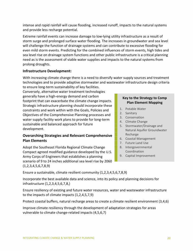
Adopt the Southeast Florida Regional Climate Change Compact agreed modified guidance developed by the U.S. Army Corps of Engineers that establishes a planning scenario of 9 to 24 inches additional sea level rise by 2060 (1,2,3,4,5,6,7,8,9)
Ensure a sustainable, climate resilient community (1,2,3,4,5,6,7,8,9)
Incorporate the best available data and science, into its policy and planning decisions for infrastructure (1,2,3,4,5,6,7,8,)
Ensure resiliency of existing and future water resources, water and wastewater infrastructure to the impacts of climate impacts (1,2,4,5,7,9)
Protect coastal buffers, natural recharge areas to create a climate resilient environment (3,4,6)
Improve climate resiliency through the development of adaptation strategies for areas vulnerable to climate change-related impacts (4,5,6,7)
Key to the Strategy to Comp Plan Element Mapping
1. Potable Water 2. Sanitary 3. Conservation 4. Climate Change 5. Stormwater/Drainage and
Natural Aquifer Groundwater Recharge
6. Coastal Management 7. Future Land Use 8. Intergovernmental
Coordination 9. Capital Improvement
INTEGRATING CLIMATE CHANGE & WATER SUPPLY PLANNING 20
Create and maintain effective intergovernmental coordination and ongoing communication that supports sustainable water supplies and resource protections while maintaining climate change preparedness (1,2,3,4,5,8)
Conduct vulnerability and risk analysis for; public infrastructure and facilities, economic, land use and natural systems - Data and Analysis in the 10 Yr. Water Supply Facility Work Plans (Technical Tools and Planning Tools)
Incorporate climate impacts, indicators, benchmarks and targets in planning elements and land use development reviews (4,7,8)
Adopt Overlay Zones, Adaptation Overlay Districts or Adaptation Action Areas in a Coastal Management Element to improve resilience to coastal flooding resulting from high-tide events, storm surge, flash floods, stormwater runoff, and related impacts of sea level rise (4,5,6,7,8,9)
Provide periodic review of the Unified Sea Level Rise Projection for Southeast Florida (1,2,3,4,5,6,7,8,9)
Specific strategies with reference to Relevant Comp Plan Elements or Planning and Zoning Considerations
Adopt protective actions in the Overlay Zones, Adaptation Overlay Districts or Adaptation Action Areas in a Coastal Management Element Adaptation Action Area such as:
♦ Type and density of use;♦ Building code and design standards;♦ Setbacks;♦ Buffer zones;♦ Conditional development and exactions;♦ Rebuilding restrictions;♦ Hard and soft armoring permits; and,♦ Rolling easements or conservation easements
Adopt revised storm design maps for stormwater and environmental permitting (5,6,7)
Establish beach management plans (3,4,6,9)
Require review of Capital Improvement Element and planned projects under the vulnerability analysis and storm design maps (4,9,7,1,2,5,6,8)
Identify areas of ‘high hazard’ or repetitive losses for future changed Land Use Designations (7,8,9,4)
Adopt model codes/promote climate change resilient building design (4,6,7,9)
Whenever possible, pursue the use of reclaimed water, and other water conservation strategies, to reduce demands on the Biscayne Aquifer or to mitigate potential effects of saltwater intrusion (1,2,3,4,8,9)
Establish adaptive management strategies and a long-term water supply plan that considers potential changes in population/rates of consumption, variable climate conditions
INTEGRATING CLIMATE CHANGE & WATER SUPPLY PLANNING 21
(temperature, rainfall, SLR) and increased water demand for energy generation over the next 100 years (1,2,4,5,8,9)
Collaborate to develop a scientific/technical knowledge base for climate change decision making, such as the regional vital signs network, advanced hydrological modeling, and down-scaled climate models (4,8)
Consider climate change impacts in the placement, siting, and design of all new water and wastewater infrastructure, and in the replacement and relocation of existing infrastructure (including wellfields, storage facilities, and flood control structures) (1,2,4,5,6,9)
Work cooperatively to identify and evaluate SLR and other water related climate change impacts on Transportation Infrastructure, such as storm surge and inland drainage, to ensure functional access to property, services, and evacuation routes (4,5,6,7,8,9)
Mitigate the causes of climate change by reducing greenhouse gas emissions through energy conservation and renewable energy production (for all users and utilities – water/energy nexus) (3,4,8,9)
Protect local ecosystems and expand green infrastructure to provide greater climate resilience for habitats, species, property and residents (e.g. urban reforestation, wetland mitigation, coastal buffers) (3,4,6,8)
Comprehensive Planning Statutory Provisions Useful in Consideration of Climate Impacts
The following statutory provisions are available as useful tools for including climate-related considerations in municipal comp plans.
The Community Planning Act (CPA) made changes to the state’s growth management laws in 2011, including the optional adaptation planning for coastal hazards and the potential impacts of sea level rise. The Adaptation Action Area, as defined in the CPA, is an optional comprehensive plan designation for areas that experience coastal flooding and that are vulnerable to the related impacts of rising sea levels for prioritizing funding for infrastructure and adaptation planning. Local governments that adopt an adaptation action area may consider policies within the coastal management element in their comprehensive plan to improve resilience to coastal flooding. Criteria for the adaptation action area may include: areas below, at, or near mean higher high water; areas which have a hydrological connection to coastal waters; or areas designated as evacuation zones for storm surge (§163.3164(1) and §163.3177(6)(g)(10), F.S.).
Section 163.3164(1), Florida Statutes
(1) “Adaptation action area” or “adaptation area” means a designation in the coastal management element of a local government's comprehensive plan which identifies one or more areas that experience coastal flooding due to extreme high tides and storm surge, and
INTEGRATING CLIMATE CHANGE & WATER SUPPLY PLANNING 22
that are vulnerable to the related impacts of rising sea levels for the purpose of prioritizing funding for infrastructure needs and adaptation planning.
Section 163.3177(6)(g)(10), Florida Statutes
At the option of the local government, develop an adaptation action area designation for those low-lying coastal zones that are experiencing coastal flooding due to extreme high tides and storm surge and are vulnerable to the impacts of rising sea level. Local governments that adopt an adaptation action area may consider policies within the coastal management element to improve resilience to coastal flooding resulting from high-tide events, storm surge, flash floods, stormwater runoff, and related impacts of sea-level rise. Criteria for the adaptation action area may include, but need not be limited to, areas for which the land elevations are below, at, or near mean higher high water, which have a hydrologic connection to coastal waters, or which are designated as evacuation zones for storm surge.
Other provisions related to Comprehensive Plan Elements
Section 163.3177(1)(f), Florida Statutes
Data and analysis. All mandatory and optional elements of the comprehensive plan and plan amendments must be based upon relevant and appropriate data and an analysis by the local government that may include, but not be limited to, surveys, studies, community goals and vision, and other data available at the time of adoption of the comprehensive plan or plan amendment. (§163.3177(1)(f), F.S.).
To be based on data means to react to it in an appropriate way and to the extent necessary indicated by the data available on that particular subject at the time of adoption of the plan or plan amendment at issue. (§163.3177(1)(f), F.S.).
Data must be taken from professionally accepted sources. (§163.3177(1)(f)2., F.S.)
The application of a methodology utilized in data collection or whether a particular methodology is professionally accepted may be evaluated. However, the evaluation may not include whether one accepted methodology is better than another. (§163.3177(1)(f)2., F.S.).
Section 163.3177(4)(a), Florida Statutes
Coordination of the local comprehensive plan with the comprehensive plans of adjacent municipalities, the county, adjacent counties, or the region; with the appropriate water management district’s regional water supply plans approved pursuant to s. 373.709; and with adopted rules pertaining to designated areas of critical state concern must be a major objective of the local comprehensive planning process. (§163.3177(4)(a), F.S.)
Section 163.3177(3)(a), Florida Statutes
The comprehensive plan must contain a capital improvements element designed to consider the need for and the location of public facilities in order to encourage the efficient use of such facilities and set forth: (§163.3177(3)(a), F.S.)
The capital improvements element must be reviewed by the local government on an annual basis. (§163.3177(3)(b), F.S.)
INTEGRATING CLIMATE CHANGE & WATER SUPPLY PLANNING 23
Section 163.3177(6)(a) 2., Florida Statutes
Future Land Use Element: The future land use plan and plan amendments must be based upon surveys, studies, and data regarding the area, as applicable, including:. . . the availability of water supplies, public facilities, and services. (§163.3177(6)(a)2., F.S.)
Other Reference Material for Water Supply Planning Florida Department of Economic Opportunity (DEO) Water Supply Planning:
http://www.floridajobs.org/community-planning-and-development/programs/technical-assistance/planning-initiatives/natural-resource-planning/water-supply-planning
The SFWMD offers technical assistance to local governments and others in meeting the statutory requirements for Water Supply Facilities Work Plans.
Information, tools and contact information are available at: www.sfwmd.gov/work_plan_support
Documents include:
• Water Supply Facilities Work Plan Update Checklist • Water Supply Facilities Work Plan Update/Amendment Guide • Template for Water Supply Facilities Work Plan Update • Frequently Asked Questions: How and Why to Update a Water Supply Facilities Work
Plan • Workshop PowerPoint Presentation • Abbreviations and Acronyms Related to Water Supply Facilities Work Plans and
Regional Water Supply Plans • Links to Regional Water Supply Plans • District Contacts for Water Supply Facilities Work Plan Update Technical Assistance
INTEGRATING CLIMATE CHANGE & WATER SUPPLY PLANNING 24
INTEGRATING CLIMATE CHANGE & WATER SUPPLY PLANNING 25
Integrating Climate Change & Water Supply Planning In Southeast FloridaCopyright 2014: Southeast Florida Regional Climate Change Compact