Embed Size (px)
Citation preview
UNITED NATIONS E/CONF.104/IP.1 ECONOMIC AND SOCIAL COUNCIL Twentieth United Nations Regional Cartographic Conference for Asia and the Pacific Jeju, 6 - 9 October 2015 Item 7(b) of the provisional agenda Invited Papers
Integrating Geospatial Information into the 2030 Agenda for Sustainable Development *
_____________ * Prepared by Mr. Greg Scott United Nations Statistics Division, University of Melbourne, and Mr. Abbas Rajabifard, University of Melbourne

UNITED NATIONS E/CONF.104/IP.1 ECONOMIC AND SOCIAL COUNCIL Twentieth United Nations Regional Cartographic Conference for Asia and the Pacific Jeju, 6 - 9 October 2015 Item 7(b) of the provisional agenda Invited Papers
Integrating Geospatial Information into the 2030 Agenda for Sustainable Development *
_____________ * Prepared by Greg Scott United Nations Statistics Division, University of Melbourne, and Abbas Rajabifard, University of Melbourne
20th United Nations Regional Cartographic Conference for Asia-Pacific Jeju Island, Republic of Korea, 6-9 October 2015 1
Integrating Geospatial Information into the 2030 Agenda for Sustainable Development
Greg Scott, United Nations Statistics Division, University of Melbourne
Abbas Rajabifard, University of Melbourne Summary Many global dialogues and processes have been convened, and reports published, on sustainable development over the past 30 years. These reach a critical juncture in 2015 when the Millennium Development Goals (MDGs), the overarching development framework for the world for the past 15 years, come to an end, and a new and ambitious post-2015 development agenda begins. This culminated on 25 September 2015 when the United Nations General Assembly adopted ‘Transforming our World: The 2030 Agenda for Sustainable Development’, a new and universal development agenda for all countries and stakeholders to use as a blueprint of action for people, planet and prosperity. The 2030 Agenda for Sustainable Development will guide the way we collectively manage and sustain our Earth through to at least 2030, and will be anchored by 17 Sustainable Development Goals (SDGs), 169 targets, and a global indicator framework, in order to measure and monitor progress. It will also capture specific and separate global United Nations (UN) system outcomes on disaster risk reduction, climate change, and financing for development. Strengthening data production and the use of better data in policymaking and monitoring are becoming increasingly recognized as fundamental means for development. The 15 year experience of the MDGs offered numerous lessons and taught us that data are an indispensable element of the development agenda. Despite significant and recognised global achievements, the MDGs failed to recognize the need for data and geography, and were limited in their ability to track and monitor progress consistently. In essence, there was no sustainable data to measure and monitor sustainable development. Poor data quality, lack of timely data, and unavailability of disaggregated data on important dimensions were among the major challenges. As a result, many national and local governments continued to rely on outdated data or data of insufficient quality to make decisions, planning and policy. Therefore, data, as the basis for evidence-based decision-making and accountability, will be a crucial pillar of the 2030 Agenda for Sustainable Development. The SDGs seek to build on the MDGs and complete what they did not achieve, and with approaches that acknowledge the need for the SDGs to: be integrated and indivisible; balance the three dimensions of sustainable development (economic, social and environmental); and to include critical data for effective measuring, monitoring and for development policymaking. The 2030 Agenda specifically demands new data acquisition and integration approaches to improve the availability, quality, timeliness and disaggregation of data to support the implementation of the new development agenda at all levels – including to exploit the contribution to be made by a wide range of data, including earth observation and geospatial information, while ensuring national ownership in supporting and tracking progress. However, despite the recognised need for geospatial information in sustainable development processes in recent years, the means for the global geospatial community to implement and integrate this valuable capability into national, regional, or global approaches has been lacking. Arguably, adequately identifying the need for, and articulating the role of, geospatial information has proven elusive in both concept and practice. At its fourth session in August 2014, the United Nations Committee of Experts on Global Geospatial Information Management (UN-GGIM) observed that “the level of understanding and rate of uptake of geospatial information, particularly at the policy and decision-making level, remains less than optimal…many do not understand its value and importance within the context of the sustainable development agenda. The production and use of geospatial information within national, regional and global policy frameworks needs to be mainstreamed in order to enhance the capability for governments, international organizations and researchers to analyse,
20th United Nations Regional Cartographic Conference for Asia-Pacific Jeju Island, Republic of Korea, 6-9 October 2015 2
model, monitor and report on sustainable development, disasters, climate change, and other global concerns”1. Like sustainable development itself the integration and implementation of geospatial information remains a challenge, but there is evidence of progress. The final 2015 MDG Report noted that geospatial data can support monitoring in many aspects of development, from health care to natural resource management. Knowing where people and things are and their relationship to each other is essential for informed decision-making. Comprehensive location-based information is helping Governments to develop strategic priorities, make decisions, and measure and monitor outcomes. Once the geospatial data are created, they can be used many times to support a multiplicity of applications.2 Goal 17 of the 2030 Agenda for Sustainable Development, under the theme ‘Data, monitoring and accountability’, calls for Member States to by 2020, increase significantly the availability of high-quality, timely and reliable data disaggregated by income, gender, age, race, ethnicity, migratory status, disability, geographic location and other characteristics relevant in national contexts3. This paper will demonstrate that, for the first time, the global geospatial information community, particularly through national geospatial information agencies, has a unique opportunity to integrate geospatial information into the global development agenda in a more holistic and sustainable manner, specifically in measuring and monitoring the targets and indicators of the SDGs within a common framework. However, in order to achieve this outcome, national geospatial information agencies will need to: collaborate more closely with national statistical and earth observation professional communities; be more unified, with similar national to global objectives and aspirations; be delivering the same data, as much as practical and depending on national circumstances; demonstrate the functionality and usefulness of the national geospatial data and how it can be integrated into the wider sustainable development policy process; and have the same policy voice at the global level through UN-GGIM.
1 E/C.20/2014/13/Add.1, 2014, para 37. http://ggim.un.org/docs/meetings/GGIM4/E-C20-2014-13%20Activities%20Related%20to%20Sustainable%20Development%20Report.pdf 2 The Millennium Development Report 2015, http://www.un.org/millenniumgoals/ 3 Transforming our world: the 2030 Agenda for Sustainable Development, Goal 17.18, p.23. https://sustainabledevelopment.un.org/content/documents/7891Transforming%20Our%20World.pdf
20th United Nations Regional Cartographic Conference for Asia-Pacific Jeju Island, Republic of Korea, 6-9 October 2015 3
Introduction Since its inception, the term ‘sustainable development’ has evolved to mean different things to different people, and in some cases, all things to all people. Hence it is a term that is as misunderstood as it is understood. Despite this ambiguity – and being open to much interpretation in its definition and ability to be measured – sustainable development is now being embraced more than ever by global leaders as the world comes to terms with ongoing and emerging development challenges, and a new 2030 Agenda for Sustainable Development. The 2030 Agenda will in fact be the agreed global and united policy to manage and transform the social, economic and environmental dimensions of humanity and our planet over the next 15 years. Interestingly, sustainable development has progressed in a similar and parallel time frame to that of geospatial information – over the past 30 years or so. It could be argued that they are both somewhat ambiguous and difficult to explain to and be understood by society at large, including global leaders, policy- and decision-makers. While achieving sustainable development presents the global community with a set of significant social, economic and environmental challenges, geospatial information is able to provide a set of science- and time-based monitoring solutions to these challenges, driven by data and with ‘geography’ as context. As noted at the second session of UN-GGIM in August 2012, “all of the issues impacting sustainable development can be analysed, mapped, discussed and/or modelled within a geographic context. Whether collecting and analysing satellite images or developing geopolitical policy, geography can provide the integrative framework necessary for global collaboration and consensus decision making”.4 However, and despite much advocacy and many global dialogues, the recognition of the critical importance of geospatial information in sustainable development processes has been very limited and, until recently, almost non-existent. Although Member States have just decided on how the world will address sustainable development for the next 15 years, and will implement 17 SDGs, including targets and indicators commencing in 2016, they have not progressed greatly in their understanding of the need for geospatial information to measure, monitor and manage the SDGs. Why is this so? Why has geospatial information not been visible as an enabling necessity in the global development agenda? What are the impediments, reasons, and lack of drivers? It is time for change. Geospatial information has matured to the extent that it is able to make a considerable contribution to the global development agenda, but how can it do so? How can geospatial information be implemented and integrated, at a policy level, in order to contribute more holistically to measuring and monitoring the targets and indicators of the SDGs? Presently, there is no evident policy or framework for governments to determine how geospatial information can be implemented and integrated into the SDGs, as an enabling technology, especially at local and national levels. This paper examines the global evolution of sustainable development, from first concepts to today’s implementation agenda, with a particular focus on the need for and references to geography and geospatial information. It then discusses this persistent policy and practice issue that is of global importance for many countries around the world, particularly the developing nations, who will struggle to measure and monitor sustainable development targets and indicators in a consistent manner. In considering the global magnitude of the problem, the size of the geospatial industry involved, and the considerable gaps in the literature, a transformative shift is required in considering how geospatial information can contribute to sustainable development. Sustainable Development – Origins Sustainable development concepts had their origins in the 1960s with the publication of Rachel Carson’s Silent Spring in 1962. Silent Spring was considered a turning point in understanding the interconnections between the environment, the economy and social well-being. It created a new public awareness that nature was vulnerable to human intervention and that the environment needed to be
4 Monitoring Sustainable Development: Contribution of Geospatial Information to the Rio+20 Processes http://ggim.un.org/2nd%20Session/GGIM%20paper%20for%20Rio_Background%20paper_18May%202012.pdf
20th United Nations Regional Cartographic Conference for Asia-Pacific Jeju Island, Republic of Korea, 6-9 October 2015 4
protected.5 Paul Ehrlich’s The Population Bomb6, published in 1968, then argued that the Earth had a finite capacity to sustain human civilization, and made controversial claims that it was doomed – that population growth and resource consumption were unsustainable – unless drastic actions were implemented to balance human population, resource exploitation and the environment. This was followed by the provocative The Limits to Growth7 published in 1972. Commissioned by the Club of Rome8, The Limits to Growth details a systems analysis of economic and population growth limited by finite resources. A computer model was used to simulate the consequences of interactions between the Earth’s and human systems. With five variables: world population, industrialization, pollution, food production, and resource depletion, the author’s explored 12 scenarios to determine possible futures from 1972 to 2100. While the popular summary was seen as ‘growth will come to an end’ – environmental and economic collapse – within a century if ‘business as usual’ continued, the main scientific conclusion of the study was that delays in global decision-making would cause the human economy to overshoot planetary limits before the growth in the human ecological footprint slowed. Once in unsustainable territory, human society would be forced to reduce its rate of resource use and its rate of emissions. With more than 40 years of hindsight available and as the world enters the critical period in which The Limits to Growth model suggests the general onset of collapse first appears, at about 2015, when per capita industrial output begins a sharp decline, updated and detailed comparisons are being made. For example, Is Global Collapse Imminent? An Updated Comparison of The Limits to Growth with Historical Data9 raises whether the current economic difficulties of the global financial crisis are potentially related to mechanisms of breakdown in The Limits to Growth business as usual scenario. Sustainable Development – Evolution While the above publications addressed issues relating to human interactions with the environment, and largely environmental in nature, the theoretical framework for sustainable development evolved in the 20 year period between 1972 and 1992 through a series of international conferences and initiatives led predominantly by the United Nations. The United Nations Conference on the Human Environment (UNCHE), convened in June 1972 in Stockholm, Sweden (also known as the Stockholm Conference), was the United Nation’s first major international conference to discuss environmental sustainability issues at the global scale. Although, embedded in the pollution and acid rain difficulties of northern Europe at the time, the Conference created considerable momentum and marked a turning point in the development of international environmental politics, emphasizing that defending and improving the environment must become a goal to be pursued by all countries. The Declaration of the Conference called upon “Governments and peoples to exert common efforts for the preservation and improvement of the human environment, for the benefit of all the people and for their prosperity”10 and outlined 26 Principles pertaining largely to environmental protection, for countries to strive for. While the term ‘sustainable development’ was not referred to explicitly, the essence of it was clearly evident. The preamble of the Declaration noted that “to defend and improve the human environment for present and future generations has become an imperative goal for mankind – a goal to be pursued together with, and in harmony with, the established and fundamental goals of peace and of worldwide economic and social development”. Principle 2 of the Declaration specifically alluded to managing 5 http://www.nrdc.org/health/pesticides/hcarson.asp 6 Ehrlich, P.R., The Population Bomb, 1968 and 1969. 7 Meadows, D. H., Meadows, D. L., Randers, J. & Behrens III, W. W., The Limits to Growth, Universe Books, New York, US, 1972. 8 The Club of Rome is a global think tank that has dealt with a variety of international political issues since 1968. http://www.clubofrome.org/ 9 http://www.ecology.ethz.ch/content/dam/ethz/special-interest/usys/ites/ecosystem-management-dam/documents/EducationDOC/Readings%20in%20Environmental%20Thinking/Turner_2012_GAIA_LimitsToGrowth.pdf 10 A/CONF.48/14/Rev.1, p. 4
20th United Nations Regional Cartographic Conference for Asia-Pacific Jeju Island, Republic of Korea, 6-9 October 2015 5
the environment for the benefit of present and future generations: “The natural resources of the earth, including the air, water, land, flora and fauna and especially representative samples of natural ecosystems, must be safeguarded for the benefit of present and future generations through careful planning or management, as appropriate”.11 The Conference also produced the Framework for Environmental Action and created the United Nations Environment Programme (UNEP). Based in Nairobi, Kenya, UNEP continues to act as a global catalyst for action to protect the environment. The mission of UNEP is "to provide leadership and encourage partnership in caring for the environment by inspiring, informing, and enabling nations and peoples to improve their quality of life without compromising that of future generations”.12 It was in the early 1980s when the United Nations General Assembly (General Assembly) began to discuss means to report on the environment, including proposed strategies for sustainable development. Recognising the need for a special, independent body to address the growing concern over the “accelerating deterioration of the human environment and natural resources and the consequences of that deterioration for economic and social development”13 the General Assembly established the World Commission on Environment and Development (WCED) in December 1983. Chaired by Norwegian Prime Minister Gro Harlem Brundtland, and comprised of representatives from both developed and developing countries, the Commission was created as an urgent call by the General Assembly to formulate “a global agenda for change" and, inter alia, to propose long-term environmental strategies for achieving sustainable development by the year 2000 and beyond.14 In April 1987, and following considerable global consultation, the Commission produced the landmark report Our Common Future15. Also known as the Brundtland Report, Our Common Future not only provided a stark diagnosis of the state of the environment, it advanced the understanding of global interdependence and the relationship between economics and the environment. The Chair’s Foreword, reaffirmed that “the ‘environment’ is where we all live; and ‘development’ is what we all do in attempting to improve our lot within that abode. The two are inseparable.” Our Common Future also introduced and captured what is now the classic definition of sustainable development: “development which meets the needs of the present without compromising the ability of future generations to meet their own needs”. It contains within the definition two key concepts: 1. The concept of ‘needs’, in particular the essential needs of the world's poor, to which overriding
priority should be given; and 2. The idea of limitations imposed by the state of technology and social organization on the
environment's ability to meet present and future needs. Acceptance of the Brundlant Report by the General Assembly in August 1987 gave ‘sustainable development’ political salience, and in June 1992 global leaders laid the foundations for the global institutionalisation of sustainable development at the ‘Earth Summit’, the United Nations Conference on Environment and Development (UNCED) in Rio de Janeiro, Brazil. Convened 20 years after the Stockholm Conference, the Earth Summit sought to help Governments rethink economic development and find ways to halt the destruction of irreplaceable natural resources and pollution of the planet. In Rio, more than 178 Governments, 108 represented by heads of State, adopted the Rio Declaration on Environment and Development, and Agenda 21 – a global plan of action for sustainable development.
11 A/CONF.48/14/Rev.1, p. 3-4 12 UNEP website 2015 http://www.unep.org/about/ 13 Drexhage, J. and Murphy, D., Sustainable Development: From Brundtland to Rio 2012, Background Paper prepared for consideration by the High Level Panel on Global Sustainability, September 2010. http://www.un.org/wcm/webdav/site/climatechange/shared/gsp/docs/GSP1-6_Background%20on%20Sustainable%20Devt.pdf 14 Our Common Future, Chairman’s Foreword http://www.un-documents.net/ocf-cf.htm 15 A/42/427 http://www.un-documents.net/wced-ocf.htm
20th United Nations Regional Cartographic Conference for Asia-Pacific Jeju Island, Republic of Korea, 6-9 October 2015 6
The Rio Declaration contained 27 principles defining the rights and responsibilities of States, while Agenda 21 outlined a comprehensive programme for global action in all areas of sustainable development, and included 40 separate chapters setting out actions in regard to the social and economic dimensions of sustainable development, conservation and management of natural resources, the role of major groups, and means of implementation. Three instruments of environmental governance were also established: two legally binding Conventions aimed at preventing global climate change ‘The United Nations Framework Convention on Climate Change’ and the eradication of the diversity of biological species ‘The Convention on Biological Diversity’; and the non-legally binding ‘Statement of Forest Principles’ – a set of principles to underlie the sustainable management of forests worldwide. The Commission on Sustainable Development was also created at the Earth Summit to monitor and report on implementation of the agreements referenced above, and it was agreed that a five year review of Earth Summit progress would be made at a session of the General Assembly. The General Assembly session, aptly named ‘Earth Summit+5’, was convened in New York in June 1997 and took stock of how well countries, international organizations and sectors of civil society had responded to the challenge of the Earth Summit. The General Assembly then convened the ‘Millennium Summit’ in New York in September 2000 in an attempt to seize a unique and symbolically compelling moment to articulate and affirm a vision to ensure that globalization becomes a positive force for all the world’s people. Attended by the largest gathering of world leaders in history, 149 Heads of State and Government and high-ranking officials from over 40 other countries, the Summit concluded with the ‘Millennium Declaration’ which contained a statement of values, principles and objectives for the 21st century. The Declaration committed nations to a new global partnership to reduce extreme poverty and setting out a series of time-bound and quantified targets, with a deadline of 2015, which have become known as the Millennium Development Goals or MDGs. The 8 MDGs are to: (1) eradicate extreme poverty and hunger; (2) achieve universal primary education; (3) promote gender equality and empower women; (4) reduce child mortality; (5) improve maternal health; (6) combat HIV/AIDS, malaria and other diseases; (7) ensure environmental sustainability; and (8) develop a global partnership for development. However, and as they come to a conclusion in 2015, the MDGs failed to recognize the need for data and geography, and were therefore very limited in their ability to track and monitor progress consistently. These limitations will be considered in more detail later in this paper. Sustainable Development – Not only the Environment Even at that time, the beginning of the 21st century, sustainable development, while representing challenges pertaining to the well-being of the Earth, was largely dominated by environmental issues, including forests and climate, and was much weaker in addressing aspects related to social and economic development. As a result of the strong environmental emphasis, sustainable development also encapsulated many elements of geography, but ironically there was no real understanding of the need, or even means, to measure and monitor development progress of these geographies, or for harnessing mapping data of a geographic nature in order to do so. At the same time, the use, uptake and technological advancements of digital mapping – GIS and CAD, data acquisition (including satellites, GPS, etc.) and automated cartographic technologies – were emerging as new and more efficient and intelligent means of mapping our world from local to global scales. It wasn’t until the World Summit on Sustainable Development (WSSD), held in Johannesburg, South Africa, in September 2002 that negotiations demonstrated a major shift in the perception of sustainable development – away from environmental issues toward social and economic development. This shift, which was driven by the needs of the developing countries and strongly influenced by the MDGs, focused considerably more attention on development issues, particularly in integrating the MDGs with sustainable development principles and practices. However, and although fundamentally critical, the political timing was simply not there; the global political leadership was not engaged
20th United Nations Regional Cartographic Conference for Asia-Pacific Jeju Island, Republic of Korea, 6-9 October 2015 7
because the world, led by the United States, was more focused on security issues around terrorism, weapons of mass destruction, and Iraq.16 That said, it was actually the 2002 Summit that emphasized the importance of an integrated approach to sustainable development, including the need for quality data and information for decision-making, and the need for geographic data was first captured in a global sustainable development dialogue. The Report of the Summit, under the topic ‘Means of Implementation’ specifically called for Member States to, inter alia: “promote the development and wider use of earth observation technologies, including satellite remote sensing, global mapping and geographic information systems, to collect quality data on environmental impacts, land use and land-use changes, including through urgent actions at all levels to….access, explore and use geographic information by utilizing the technologies of satellite remote sensing, satellite global positioning, mapping and geographic information systems”.17 How geographic information would actually be applied to sustainable development challenges, or be implemented, was not articulated. There was simply no apex intergovernmental mechanism in existence that could suitably address the production and use of geographic information within national, regional and global policy frameworks – or how they could be applied to sustainable development challenges. Sustainable Development – Capturing the Need for Geospatial Information Twenty years on from the 1992 Rio Earth Summit, the United Nations Conference on Sustainable Development (UNCSD), or Rio+20, was convened in June 2012, again in Rio de Janeiro, Brazil. Rio+20 was pivotal in that it sought to re-engage the world on a sustainable development pathway and initiated the process for a new development agenda for the future. The focused political outcome document The Future We Want contained clear and practical measures for implementing sustainable development, including setting the path to develop a set of Sustainable Development Goals (SDGs) to build upon the MDGs, and to converge with the post-2015 development agenda. The Future We Want captured two critical references to geospatial information within the document’s framework for action and follow-up, and through provision of means of implementation. These were specifically in the area of disaster risk reduction: “We further recognize the importance of comprehensive hazard and risk assessments, and knowledge- and information-sharing, including reliable geospatial information”18 and in the area of means of implementation – technology: “We recognize the importance of space-technology-based data, in situ monitoring and reliable geospatial information for sustainable development policymaking, programming and project operations.”19 Again, and despite its recognised importance and need, this outcome document did not articulate how reliable geospatial information, including data and technologies, would be integrated into the many sustainable development policy and practice processes. However, at Rio+20, Member States resolved to establish an inclusive and transparent intergovernmental process to develop the SDGs, stating that they should be limited in number, aspirational and easy to communicate. The goals should address, in a balanced way, all three dimensions of sustainable development and be coherent with and integrated into the United Nations development agenda beyond 2015. A 30-member Open Working Group on Sustainable Development Goals of the General Assembly (OWG) was established in January 2013 tasked with preparing a proposal on the SDGs for consideration by the Assembly during its 68th session in September 2014. Over an 18 month period, and predominantly through 13 intergovernmental sessions, the OWG formulated a set of 17 proposed SDGs, accompanied by 169 action orientated targets, to be attained by 2030.
16 Sustainable Development: From Brundtland to Rio 2012, Drexhage and Murphy, International Institute for Sustainable Development, 2010, p. 9-10. 17 A/CONF.199/20, 2002, para 132. 18 A/RES/66/288, 2012, para. 187. 19 A/RES/66/288, 2012, para. 274.

20th United Nations Regional Cartographic Conference for Asia-Pacific Jeju Island, Republic of Korea, 6-9 October 2015 8
The Open Working Group Proposal for Sustainable Development Goals20 was submitted to the General Assembly in September 2014, and endorsed as the basis for integrating SDGs into the post-2015 development agenda, while recognizing fully that other inputs may also be considered in this intergovernmental negotiation process at the 69th session of the General Assembly.21 Goal 17: ‘Strengthen the means of implementation and the global partnership for sustainable development’, under the sub-item ‘Data, monitoring and accountability’ contained the following paragraph: “by 2020, increase significantly the availability of high-quality and timely data disaggregated by income, gender, age, race, ethnicity, disability, geographic location and other characteristics relevant in national contexts, with capacity building support to developing countries, especially least developed countries (LDCs)”. During the period January to July 2015, a number of intergovernmental negotiations on the post-2015 development agenda, and building on the proposal by the OWG, were convened by the General Assembly. These intense intergovernmental negotiations concluded on Sunday 2 August 2015, with Member States agreeing by consensus to adopt ‘Transforming our World: The 2030 Agenda for Sustainable Development’22 at the United Nations Sustainable Development Summit23 to be held in New York from 25 to 27 September 2015. The 2030 Agenda for Sustainable Development will in fact be the agreed global and united policy to manage and transform the social, economic and environmental dimensions of humanity and our planet over the next 15 years in order to shift the world onto a sustainable and resilient path. This new transformative Agenda will be informed by 3 other key global processes which are also being determined in 2015: 1. The Sendai Framework for Disaster Risk Reduction 2015–2030.24 2. The 3rd International Conference on Financing for Development (held 13-16 July 2015) and the
outcome finance commitments in the Addis Ababa Action Agenda.25 3. The 21st Session of the Conference of the Parties to the United Nations Framework Convention
on Climate Change (COP21/CMP11), to be convened in Paris from November 30 to December 11 2015.26 COP21 will be a crucial conference, as it needs to achieve a new international agreement on the climate, applicable to all countries, with the aim of keeping global warming below 2°C.
With 17 goals and 169 targets, the 2030 Agenda contains much more accountability than the MDGs with considerable emphasis on measuring and monitoring with good policy, science, technology and especially data. The implementation and subsequent monitoring of progress of the Agenda will be supported by a global indicator framework that is being formulated presently by the Inter-agency Expert Group on Sustainable Development Goal Indicators (IAEG-SDGs).27 The role of the IAEG-SDGs will be discussed in more detail later in this paper. Within the text of the 2030 Agenda for Sustainable Development there is a specific reference to the need for high quality, timely, reliable and disaggregated data, including earth observation and geospatial information in the area of follow up and review: “We will support developing countries, particularly African countries, LDCs, SIDS and LLDCs, in strengthening the capacity of national statistical offices and data systems to ensure access to high quality, timely, reliable and disaggregated data. We will promote transparent and accountable scaling-up of appropriate public-private cooperation to exploit the contribution to be made by a wide range of data, including earth observation and geospatial information, while ensuring national ownership in supporting and tracking progress.”28 This need has a goal, target and date associated with it, as described in Goal 17 in the area of data, monitoring and accountability: “By 2020, enhance capacity-building support to developing countries, including for least developed countries and small island developing States, to 20 https://sustainabledevelopment.un.org/content/documents/1579SDGs%20Proposal.pdf 21 A/68/L.61 22 A/69/L.85 23 https://sustainabledevelopment.un.org/post2015/summit 24 A/RES/69/283 25 http://www.un.org/esa/ffd/wp-content/uploads/2015/08/AAAA_Outcome.pdf 26 http://www.cop21paris.org/about/cop21 27 http://unstats.un.org/sdgs/iaeg-sdgs/index.html 28 A/69/L.85, para. 76.
20th United Nations Regional Cartographic Conference for Asia-Pacific Jeju Island, Republic of Korea, 6-9 October 2015 9
increase significantly the availability of high-quality, timely and reliable data disaggregated by income, gender, age, race, ethnicity, migratory status, disability, geographic location and other characteristics relevant in national contexts.”29 The 2030 Agenda for Sustainable Development has articulated the need for Member States by 2020 – in 5 years – to increase significantly the availability of high-quality, timely and reliable data disaggregated by income, gender, age, race, ethnicity, migratory status, disability, geographic location and other characteristics relevant in national contexts. And do so by addressing the capacities of the least developed countries and small island developing states first! In negotiating this critical outcome document, the political decision-makers and diplomats from Member States were primarily concerned with agreeing on important global and national issues: hunger, poverty, disease, urbanization, water scarcity, land management, climate change, disasters and other environmental challenges. That was rightly their lens. However, we can immediately recognise, through our location lens, that geography is linked to many, if not all, of the SDGs….but what and where is the relevance and benefit, and what does this really mean for the geospatial professional community in Member States? Further, how will these important issues be measured and monitored? What are the signals or indicators of progress being made? What is the framework? Is there a geographic context? Where is the evidence coming from? How do we identify where these social, environmental and economic conditions occur? Where does geospatial information fit? What is the role of national mapping and other related agencies in Member States? We will come back to these questions, but first it is valuable to consider where geospatial information fits in the global sustainable development dialogue, and the one greatest geospatial information policy challenge that continues to plague us – awareness. Despite the significant advances in geospatial technologies, location-based services, satellites, positioning systems, ubiquitous data, the data revolution, big data, the web, etc. there is still a lack of awareness, understanding and uptake, particular at the policy and decision-making level, of the vital and integrative role of geospatial information in the sustainable development agenda. But considerable progress is being made. The Geospatial Information Policy Challenge – Understanding and Awareness The global importance of geospatial information was recognised by the United Nations in July 2011 when, at its 47th plenary meeting, the Economic and Social Council (ECOSOC), recognizing the urgent need to take concrete action to strengthen international cooperation in the area of global geospatial information management, established the United Nations Committee of Experts on Global Geospatial Information Management (UN-GGIM). 30 ECOSOC established the Committee of Experts as the apex intergovernmental mechanism for making joint decisions and setting directions with regard to the production and use of geospatial information within national, regional and global policy frameworks. Led by United Nations Member States, UN-GGIM aims to address global challenges regarding the use of geospatial information, including in the development agenda, and to serve as a guide for global policymaking in the field of geospatial information management. The report of the Secretary-General which led ECOSOC to establish UN-GGIM explicitly mentioned the role of geospatial information in informing sustainable development policies, including their monitoring and implementation. In this regard, UN-GGIM is important because it signals to national leaders and governments the significance of geospatial information in addressing national, regional and global challenges. It also provides the forum for developing common global goals, guidelines and best practices to make the use of geospatial information for sustainable development pervasive. At its first intergovernmental session, held in October 2011, the UN-GGIM Committee of Experts stressed its commitment to Rio+20 discussions, and reflected on how it could take up the challenge and make a contribution to the forthcoming Conference. This included considering the need for an
29 A/69/L.85, Goal 17.18. 30 Report of the Secretary-General on Global Geospatial Information Management, E/2011/89, http://www.un.org/ga/search/view_doc.asp?symbol=E/2011/89

20th United Nations Regional Cartographic Conference for Asia-Pacific Jeju Island, Republic of Korea, 6-9 October 2015 10
integrative framework where very different types of information on the environment and social-economic development could be integrated into a common framework. The Committee noted that “building such a common framework, which would allow to link physical tangible and non-physical intangible data alike, and which would be critical for understanding the human/environment relationship, has been a daunting task for the various actors in sustainable development.”31 The Committee also noted that it is increasingly recognized that geography and location, the physical platform where virtually all human activity takes place, provides the key linkage and, thus, an integrative spatial framework for collecting, processing, storing and aggregating all types of data. The Committee agreed to create a task force to prepare a written contribution for Rio+20 to ensure all Member States benefit from the value of geospatial information applied to sustainable development and other areas of human and global challenges. In addition to the preparation of this technical report ‘Monitoring Sustainable Development: Contribution of Geospatial Information to the Rio+20 Processes’,32 numerous informal consultations among Member States took place in the lead up to the Conference in order to discuss strategies on how to highlight the support geospatial information tools and methodologies can provide to assess progress in the cross-sectoral areas impacting sustainable development. During the Rio+20 Conference, UN-GGIM had a presence at two side events33 to demonstrate the importance of geospatial information in monitoring sustainable development and to help deliver on the outcomes of Rio+20. The UN-GGIM Secretariat, in partnership with the United Kingdom Government, organized a side event ‘Monitoring Sustainable Development: Why Location Matters’. The purpose of the side event was to demonstrate the vital role accurate, maintained and reliable geospatial information can play in helping to deliver and monitor sustainable development across the globe and in providing financial benefits to users, and why UN-GGIM is an important forum to facilitate this. The second side event ‘Global Map for Sustainable Development’ was organized by the Geospatial Information Authority (GSI) of Japan, and was supported by the International Steering Committee for Global Mapping (ISCGM) and the Japan Aerospace Exploration Agency (JAXA), and demonstrated the need for consistent global-scale data, developed under international cooperation, to monitor sustainable development, disasters, and environmental indicators. Following Rio+20, and as the post-2015 development agenda evolved, concerted and ongoing efforts have been made by UN-GGIM in increasing the visibility and awareness of geospatial information, as an essential integrative tool to monitor and measure sustainable development, to policy and decision-makers and the diplomatic community. During the seventh session of the Open Working Group, convened in New York in January 2014, the Secretariat of UN-GGIM convened a side event on ‘The Role of Geospatial Information in Measuring and Monitoring the Sustainable Development Goals: Disaster risk reduction, sustainable development, and global urbanization’.34 The aim of the side event was to introduce Open Working Group members to the importance of reliable geospatial information and its role in measuring and monitoring the SDGs, particularly with regard to geography, and to allow time for an interactive dialogue. The side event included presentations from Member States that clearly demonstrate the critical role that geospatial information is able to play in measuring and monitoring the post-2015 development agenda with a particular focus on disaster risk reduction, sustainable development, and urbanization. The two key messages delivered to participants were: geospatial information services and platforms have become key contributors to improved decision making and policy formulation, and have enhanced the capability for governments, international organizations and researchers to analyse, monitor and report on sustainable development and other global concerns; and the SDGs will depend on human and
31 E/C.20/2011/4, para. 5. 32 Monitoring Sustainable Development: Contribution of Geospatial Information to the Rio+20 Processes http://ggim.un.org/2nd%20Session/GGIM%20paper%20for%20Rio_Background%20paper_18May%202012.pdf 33 http://ggim.un.org/rio20.html 34 http://ggim.un.org/OWG.html
20th United Nations Regional Cartographic Conference for Asia-Pacific Jeju Island, Republic of Korea, 6-9 October 2015 11
physical geography data and geospatial information to measure and monitor change and progress. There will be a need to create a network of global data and information that is supported by the tools and technology to create maps and detect and monitor change over time in a consistent and standardized manner. The Third High Level Forum on UN Global Geospatial Information Management was convened in Beijing, China, in October 2014. Under the overarching theme of ‘Sustainable Development with Geospatial Information’ participants discussed the critical roles of geospatial information science, technology and innovation, as tools that are able to integrate the three pillars (economic, social, environmental) of sustainable development, and as important geographic elements of the post-2015 development agenda.35 The Forum noted the reality that no country has yet achieved a complete sustainable development phase and, given this sobering reality, that UN-GGIM should consider elements including: the need for geospatial indicators to better monitor and measure sustainable development; the importance of integrating land and water related information; and the urgency of translating geospatial information into targets and indicators under a monitoring framework, where data needs are recognised as an integral part of the development agenda. The Forum also recognised the reality that if the geospatial community was not able to provide the appropriate information in a timely manner, decision-makers will look for alternate sources, and hence, the imperative to increase advocacy efforts across the global geospatial community and that we are at the crossroads of opportunity or missed opportunity – or it is “now or never”.36 Recognizing the importance of geospatial information in national and global development, participants issued the Beijing Declaration at the conclusion of the Third High Level Forum.37 They resolved to “urgently deploy their collective competencies and capacities to advance the critical role of geospatial information in the ongoing debate on sustainable development and the post-2015 development agenda, particularly with regard to measuring and monitoring SDG targets and indicators consistently over space and time, and in doing so invite all national geospatial experts to work closely with their governments leading up to September 2015 to demonstrate the vital role of geospatial information for sustainable development.” In April 2015 the UN-GGIM Secretariat, in partnership with UNGGIM: Europe and the Group on Earth Observations (GEO), organised a very successful side event on the margins of the post-2015 intergovernmental negotiations (Means of implementation and global partnership for sustainable development). The side event ‘Unleashing the Power of ‘Where’ to Make the World a Better Place: How Geographic Information Contributes to Achieving the SDGs’38 and hosted by the Permanent Mission of Denmark, provided powerful messages that geospatial and earth observation information, combined with other information, will help countries to measure and monitor the implementation of the SDGs, including targets and indicators, in a consistent manner over time. In his introduction the Deputy Permanent Representative of Denmark to the United Nations stated that “many of the challenges we face in our discussions on sustainable development are crosscutting in nature and characterized by complex interlinkages – thus they are challenges which can benefit from unleashing the power of location (the ‘where’) – as the thing they have in common. In order to effectively measure, monitor and mitigate challenges we need to link demographic, statistical and environmental data together with the one thing they have in common – geographic location”.39 Recognising the consistent lack of awareness by decision-makers, a promotional video ‘Everything that happens, happens somewhere’40 was prepared by the Secretariat and presented at the start of the side event with the objective of demonstrating, in simple language, what geographic information is and how it can be used in sustainable development, and to increase the awareness of the importance of
35 http://ggim.un.org/3rd%20HLF.html 36 http://ggim.un.org/docs/meetings/3rd%20HLF/20141024%20HLF3%20summary.pdf 37 http://ggim.un.org/docs/meetings/3rd%20HLF/Beijing%20Declaration%2024Oct2014%20FINAL.pdf 38 http://ggim.un.org/Unleashing%20the%20Power.html 39 http://ggim.un.org/docs/meetings/SDG/Ambassador%20statement%20-%20final.pdf 40 https://www.youtube.com/watch?v=Mkge03NJhfU&feature=youtu.be
20th United Nations Regional Cartographic Conference for Asia-Pacific Jeju Island, Republic of Korea, 6-9 October 2015 12
geospatial information to the UN diplomats. This video was well received and provided a considerable level of new understanding. The High-level Political Forum on Sustainable Development (HLPF), established at Rio+20, is the peak United Nations platform dealing with sustainable development. It provides political leadership and guidance; follows up and reviews progress in implementing sustainable development commitments; addresses new and emerging sustainable development challenges; and enhances the integration of economic, social and environmental dimensions of sustainable development. Also established at Rio+20 was the Global Sustainable Development Report (GSDR), which is to be the publication aiming to strengthen the science-policy interface and released annually at the HLPF. The UN-GGIM Secretariat was invited to participate in the drafting process of the 2015 edition of the GSDR41, with the main contribution being contained in a special focus chapter ‘Chapter 8: New Data Approaches for Monitoring Sustainable Development Progress: The Case of Africa’ where geospatial tools such as geographic information systems (GIS) were seen as an effective platform to integrate multiple data sources including “big” and “small” data to provide evidence-based information for policy makers. With emphasis being provided by a number of exemplar African case studies, the chapter reflected on a number of key messages: 1. Without accurate geodetic information, data location and integration, particularly from multiple
sources, is not fruitful. Hence, the adoption of the Global Geodetic Reference Frame for Sustainable Development by the United Nations General Assembly42 could benefit the region of Africa further by having a global framework to improve the positional accuracy of data in Africa, through the regional initiatives of the African Geodetic Reference Frame (AFREF) project.
2. There is an increasing tendency to now make use of multiple data sources: official statistics, geospatial and satellite data, big data, scientific data, data produced by NGOs and research foundations, data from the media, from the crowd and from the business sector. To explore the full potential of these data sources, the data needs to be easily accessible, interoperable and standardised – so that users are able to integrate difference sources and types of information. Data, and its metadata, needs to be open access (i.e. free and accessible).
3. Geospatial information is increasingly being used in Africa, but more capacity building will be needed to scale up existing initiatives and to bring innovative applications from other parts of the world to Africa. The lack of consistent up-to-date base mapping – fundamental geographic datasets such as geodetic control, elevation, drainage, transport, land cover, geographic names, land tenure, etc. – across Africa remains a challenge, although individual countries are making progress.
Whilst increasing the awareness of geospatial information at the policy level, additional effort has been made by UN-GGIM to leverage existing partnerships and user communities of geospatial information, in such areas as disaster risk reduction, earth observations and the information communication technologies. The Third World Conference on Disaster Risk Reduction, convened in Sendai, Japan in March 2015, led to the adoption of the ‘Sendai Framework for Disaster Risk Reduction 2015-2030’43 which recognised the importance of developing, updating and disseminating location-based disaster risk information, including risk maps, to decision-makers by using geospatial technology, and how technology such as geographic information systems (GIS) can be useful to measure, collect, analyse and disseminate relevant data. The global geospatial community has been encouraged to promote real-time access to and provide timely evidence-based data and information for sustainable decision making and policy making for the future. The focus on the messaging, that the post-2015 development debate provides a convergence moment for seizing the power of geospatial data and information, has had a positive increase of awareness within the diplomatic community. The increased inferences where the geospatial community has been
41 https://sustainabledevelopment.un.org/globalsdreport/2015 42 A/RES/69/266. http://ggim.un.org/docs/A_RES_69_266_E.pdf 43 http://www.preventionweb.net/files/43291_sendaiframeworkfordrren.pdf

20th United Nations Regional Cartographic Conference for Asia-Pacific Jeju Island, Republic of Korea, 6-9 October 2015 13
working in tandem with the statistical and earth observation communities has been positive, and must be seen as a model that should be replicated to other professional communities such as the disaster response community. The reality of different professional communities having the same intent on contributing to the United Nations development agenda provides UN-GGIM the need to continue its awareness raising and education efforts at local, national, regional and global levels. Sustainable Data for Sustainable Development As described in some detail in this paper, there is considerable and concise documentation on the origins and evolution of sustainable development, its role in the UN system and its influence in the global agenda over the past 30 years. Conversely, very little is documented or understood regarding the role of geography in sustainable development processes at the intergovernmental level, including how geospatial information can be applied to sustainable development, and how policies can be implemented to bring the two together in a coherent and integrated manner. In some respects this is a reflection of the considerable technical – policy gap that exists within and across countries, but it is also a reflection of the different philosophies of each community. The sustainable development philosophy is very much concerned with reaching political negotiation and agreement on very high level global objectives for the future of our planet. The geospatial information philosophy is more concerned with making reliable and authoritative local to national data available on the interactions of people with their environment. Therefore, there are obvious differences in understanding and in terminologies, especially in the data requirements to support the many social, economic and environmental dimensions of sustainable development, including measuring and monitoring. But today, in this watershed year of 2015, more than ever before these differences are being brought together – motivated partly by will and understanding, and partly by pure necessity. As we prepare to implement a new and ambitious development agenda for the next 15 years, 2015 also enables us to reflect on our global development efforts over the past 15 years. Released in July 2015 by the UN Secretary-General, the final Millennium Development Goals Report44 provided an opportunity to not only record the significant progress in lifting more than one billion people out of extreme poverty, but to also consider some of the important shortfalls encountered and numerous lessons learned as we tried to achieve the eight aspirational goals. The major lesson – the monitoring of the MDGs taught us that data are an indispensable element of the development agenda. Without the effective use of consistent and reliable data, measuring and monitoring progress is limited considerably, and evidence-based decision- and policy-making is not possible. What gets measured gets done – what does not get measured does not get done! The MDG Report 2015 reflects in some detail, under the topic ‘Measure what we treasure: sustainable data for sustainable development’,45 the need for better data to support the implementation of the new development agenda at all levels. Many of these reflections are highly relevant to the arguments pertaining to geospatial information contained within this paper. These include: real data improvement occurs when demand and policy support meet; despite improvement, critical data for development policymaking are still lacking; real-time data are needed to deliver better decisions faster; geospatial data can support monitoring in many aspects of development, from health care to natural resource management; new technology is changing the way data are collected and disseminated; global standards and an integrated statistics system are key elements for effective monitoring; and data should be open, easily accessible and effective for development decision-making. In the area of ‘Geospatial data can support monitoring’ the report specifically acknowledged the importance of geospatial information “Knowing where people and things are and their relationship to each other is essential for informed decision-making. Comprehensive location-based information is helping Governments to develop strategic priorities, make decisions, and measure and monitor outcomes. Once the geospatial data are created, they can be used many times to support a multiplicity of applications.”
44 http://www.un.org/millenniumgoals/2015_MDG_Report/pdf/MDG%202015%20rev%20(July%201).pdf 45 The Millennium Development Goals Report 2015, United Nations, New York, 2015, p. 10.
20th United Nations Regional Cartographic Conference for Asia-Pacific Jeju Island, Republic of Korea, 6-9 October 2015 14
Integrating Geospatial Information into the Development Policy Agenda Strengthening data production and the use of better data in policymaking and monitoring are becoming increasingly recognized as fundamental means for development. On 25 September 2015, the General Assembly adopted Transforming our World: The 2030 Agenda for Sustainable Development and will implement it with 17 goals and 169 targets. The 2030 Agenda specifically demands new data acquisition and integration approaches to improve the availability, quality, timeliness and disaggregation of data to support the implementation of the new development agenda at all levels – including to exploit the contribution to be made by a wide range of data, including earth observation and geospatial information, while ensuring national ownership in supporting and tracking progress. Therefore, and reverting back to the introduction of this paper: How can geospatial information be implemented and integrated, at a policy level, in order to contribute more holistically to measuring and monitoring the targets and indicators of the SDGs? This paper provides the context and evidence advocating that the global geospatial information community, particularly through national geospatial information agencies, not only has a unique opportunity to integrate geospatial information into the global development agenda in a more holistic and sustainable manner, but also now has the political convening power, voice and instruments to do so through a global intergovernmental body – UN-GGIM. As recently as August 2015, when UN-GGIM convened its fifth session in New York and as the 2030 Agenda for Sustainable Development was being agreed in the intergovernmental negotiations, national representatives of Member State geospatial information agencies considered and discussed this unique ‘policy’ opportunity at length. UN-GGIM noted that, although fundamental to measuring and monitoring the targets and indicators of the SDGs, the reality is that the science-policy-data nexus, and related understanding, still poses challenges for the geospatial community in Member States, particularly on how best to consolidate efforts in demonstrating how and where geospatial information can contribute to efforts in national agendas. Arguably, the role of geospatial information in contributing to sustainable development is not yet adequately captured or described by the sustainable development policy practice, national geospatial information policy arrangements, or by the professional geospatial community. Although recognising the obvious importance and need, these global policy documents, agreed by Member States (including the 2030 Agenda for Sustainable Development), do not articulate how geospatial information, including data, methodologies, capacities and technologies, would be integrated into the many sustainable development policy and practice processes. UN-GGIM further noted that location and geography matters to all, and this notion is now universal due to advances in mobile technology and the global saturation of devices. Geospatial technologies and location-aware devices have revolutionized the availability and volume of location-based information. While being disruptive, it is important to harness the value of geospatial information and apply greater efforts to increase awareness of the use of geospatial information in addressing the challenges for measuring and monitoring progress over time, including of the SDGs. In this regard, UN-GGIM continues to deploy their collective competencies and capacities to advance the critical role of geospatial information into the post-2015 development agenda, particularly with regard to measuring and monitoring SDG targets and indicators consistently over space and time. In the context of the SDG targets and indicators, the statistical community, under the auspices of the Statistical Commission, has been considering its contribution on how to monitor and measure development progress for some time, based on the experiences of the MDGs. In this regard, during the 46th session of the Statistical Commission, held in New York in March 2015, the Commission endorsed a roadmap for the development and implementation of a global indicator framework, and the formation of the Inter-Agency Expert Group on SDG Indicators (IAEG-SDGs) consisting of 28 representatives of national statistical offices and, as observers, representatives of regional commissions and regional and international organizations and agencies, that will be tasked with developing a proposal for the indicator framework for the monitoring of the goals and targets of the post-2015 development agenda at the global level.
20th United Nations Regional Cartographic Conference for Asia-Pacific Jeju Island, Republic of Korea, 6-9 October 2015 15
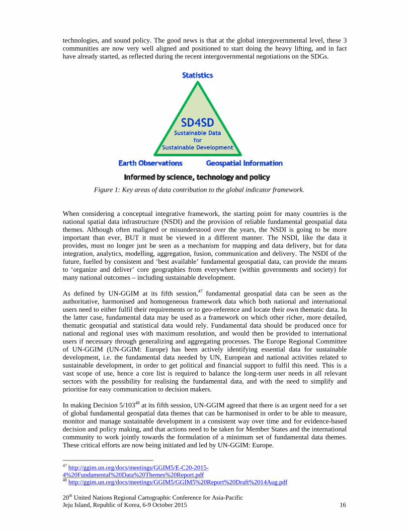
Whilst these interlinkages are essential, many of the targets are thematic based, which therefore provides an opportunity for the global geospatial community to ensure to communicate that geospatial information can provide the baseline to the IAEG-SDGs indicator development, as they occur in a location-based environment. The intent is to present the finalised indicator framework to the 47th session of the Statistical Commission in March 2016 for endorsement. In view of this, it was essential for UN-GGIM to communicate to the statistical community the value proposition of geospatial information, as a fundamental baseline for the global indicator framework, and for the measuring and monitoring of the SDGs. As a concrete measure, at its fifth session, through Decision 5/101,46 UN-GGIM committed to working closely with the statistical community, both at a national and global level, by providing inputs into the processes to develop the global indicator framework under the auspices of the Inter-agency Expert Group on SDG Indicators (IAEG-SDGs), as many goals have a geospatial dimension. As a means to do so, UN-GGIM supported the nomination of a limited number of Member State geospatial experts to the IAEG-SDGs in order to provide inputs into the development of the indicator framework, and agreed to the proposal of setting up a small task team to assist in developing the inputs, building on existing work and ongoing working mechanisms. In making this decision, UN-GGIM noted the importance of standards, the need for supporting the Sendai Framework for Disaster Risk Reduction 2015-2030, and that for the implementation of the global indicator framework in the future, appropriate resources and the commitment of policy makers will be necessary. A Conceptual Integrative Geospatial Framework A global indicator framework will be determined by the IAEG-SDGs in the coming months, and will guide how national governments in Member States measure, monitor and report on the SDGs and related targets in the years to come, based on individual national circumstances. But what does this mean in determining how geospatial information can be implemented and integrated into the indicator framework, as an enabling technology, especially at local and national levels – and what is the role of the national geospatial information agencies? In practical terms, is it possible to measure and monitor the targets and indicators of the SDGs not only within a statistical framework, but also within a geospatial framework? Because each national circumstance is different, how governments acquire, manage and disseminate geospatial information is as complicated as dealing with sustainable development itself, they are both so cross-cutting across many, if not all, government agencies and aspects of policy. Further, while geospatial is a technological enabler, sustainable development is more elusive and open to interpretation and definition, but somehow it must be measured. This infers that the sustainable use of science and data must be part of the policy process for governments; although there is often quite a gap between what science measures and how policies are designed and/or implemented. In terms of the data requirements – sustainable data for sustainable development – unlike the MDGs, which were just eight goals and limited targets, the SDGs are 17 goals with 169 targets and potentially many more indicators. To measure and monitor their implementation and progress will require huge amounts of data, much of it new or re-purposed data, more rigorous modelling and analysis, and much better data management. It will also take transformative change and collaborative approaches to link different data – demographic, statistical, earth observations, environmental and other societal geospatial data together with the one thing they have in common – geographic location. As witnessed by the exponential growth in location-based services in industry and the private sector, the location element of data, including statistical data, is going to be critical in the future. This means considering geospatial data more for its ‘information value’, rather than where it has come from or who owns it. As a minimum, sustainable data for sustainable development will require consistent statistical, geospatial and earth observation data as the core data inputs into the global indicator framework. Although a simplistic view, Figure 1 visualises what we may need to consider in terms of the key areas of data contribution to the indicator process, and informed by good science, enabling
46 http://ggim.un.org/docs/meetings/GGIM5/GGIM5%20Report%20Draft%2014Aug.pdf
20th United Nations Regional Cartographic Conference for Asia-Pacific Jeju Island, Republic of Korea, 6-9 October 2015 16
technologies, and sound policy. The good news is that at the global intergovernmental level, these 3 communities are now very well aligned and positioned to start doing the heavy lifting, and in fact have already started, as reflected during the recent intergovernmental negotiations on the SDGs.
Figure 1: Key areas of data contribution to the global indicator framework. When considering a conceptual integrative framework, the starting point for many countries is the national spatial data infrastructure (NSDI) and the provision of reliable fundamental geospatial data themes. Although often maligned or misunderstood over the years, the NSDI is going to be more important than ever, BUT it must be viewed in a different manner. The NSDI, like the data it provides, must no longer just be seen as a mechanism for mapping and data delivery, but for data integration, analytics, modelling, aggregation, fusion, communication and delivery. The NSDI of the future, fuelled by consistent and ‘best available’ fundamental geospatial data, can provide the means to ‘organize and deliver’ core geographies from everywhere (within governments and society) for many national outcomes – including sustainable development. As defined by UN-GGIM at its fifth session,47 fundamental geospatial data can be seen as the authoritative, harmonised and homogeneous framework data which both national and international users need to either fulfil their requirements or to geo-reference and locate their own thematic data. In the latter case, fundamental data may be used as a framework on which other richer, more detailed, thematic geospatial and statistical data would rely. Fundamental data should be produced once for national and regional uses with maximum resolution, and would then be provided to international users if necessary through generalizing and aggregating processes. The Europe Regional Committee of UN-GGIM (UN-GGIM: Europe) has been actively identifying essential data for sustainable development, i.e. the fundamental data needed by UN, European and national activities related to sustainable development, in order to get political and financial support to fulfil this need. This is a vast scope of use, hence a core list is required to balance the long-term user needs in all relevant sectors with the possibility for realising the fundamental data, and with the need to simplify and prioritise for easy communication to decision makers. In making Decision 5/10348 at its fifth session, UN-GGIM agreed that there is an urgent need for a set of global fundamental geospatial data themes that can be harmonised in order to be able to measure, monitor and manage sustainable development in a consistent way over time and for evidence-based decision and policy making, and that actions need to be taken for Member States and the international community to work jointly towards the formulation of a minimum set of fundamental data themes. These critical efforts are now being initiated and led by UN-GGIM: Europe.
47 http://ggim.un.org/docs/meetings/GGIM5/E-C20-2015-4%20Fundamental%20Data%20Themes%20Report.pdf 48 http://ggim.un.org/docs/meetings/GGIM5/GGIM5%20Report%20Draft%2014Aug.pdf
20th United Nations Regional Cartographic Conference for Asia-Pacific Jeju Island, Republic of Korea, 6-9 October 2015 17
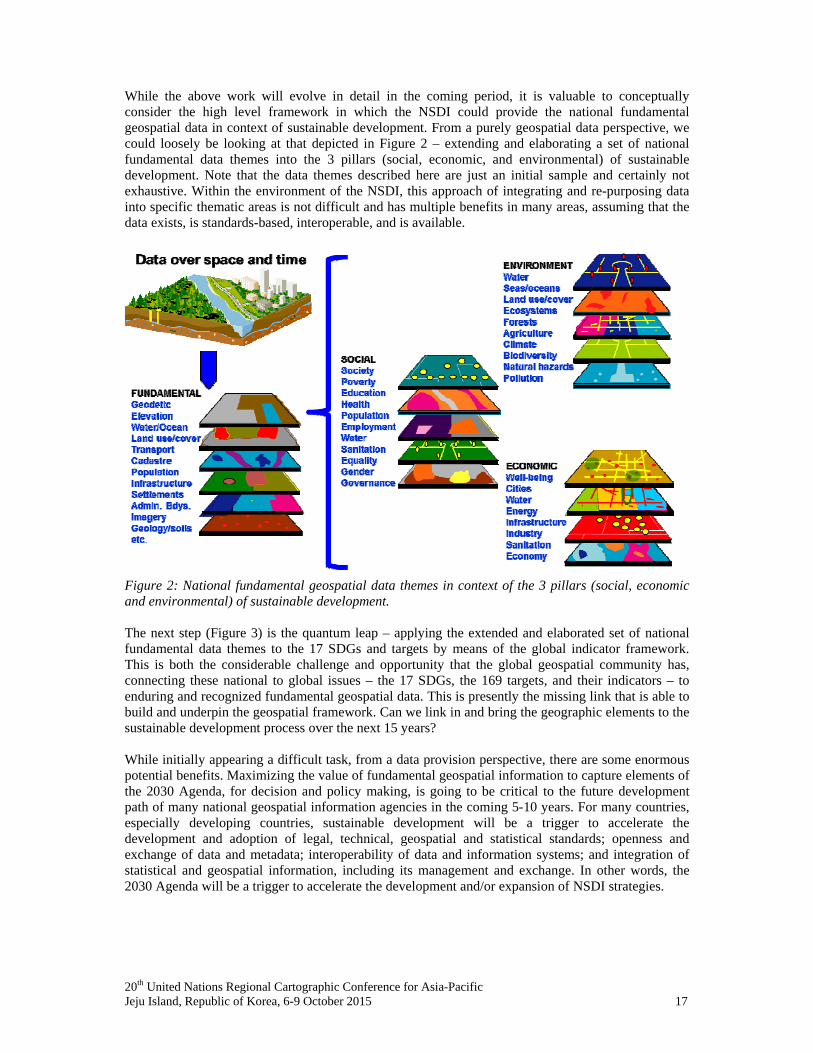
While the above work will evolve in detail in the coming period, it is valuable to conceptually consider the high level framework in which the NSDI could provide the national fundamental geospatial data in context of sustainable development. From a purely geospatial data perspective, we could loosely be looking at that depicted in Figure 2 – extending and elaborating a set of national fundamental data themes into the 3 pillars (social, economic, and environmental) of sustainable development. Note that the data themes described here are just an initial sample and certainly not exhaustive. Within the environment of the NSDI, this approach of integrating and re-purposing data into specific thematic areas is not difficult and has multiple benefits in many areas, assuming that the data exists, is standards-based, interoperable, and is available.
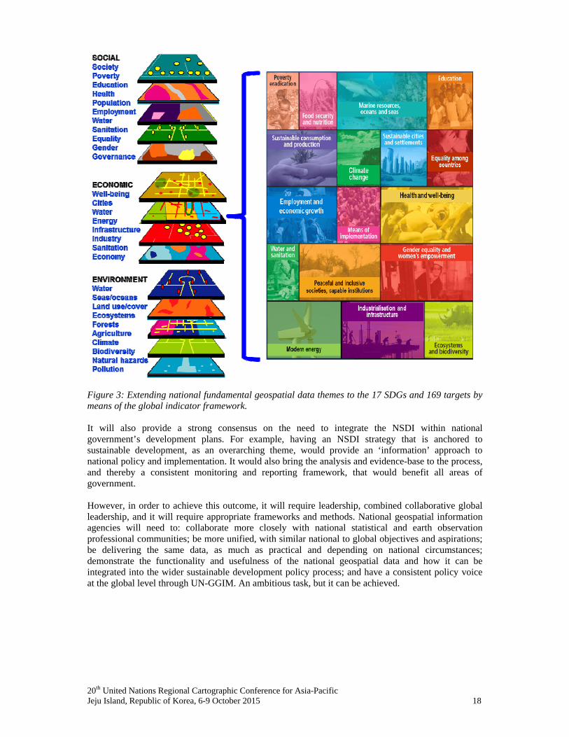
Figure 2: National fundamental geospatial data themes in context of the 3 pillars (social, economic and environmental) of sustainable development. The next step (Figure 3) is the quantum leap – applying the extended and elaborated set of national fundamental data themes to the 17 SDGs and targets by means of the global indicator framework. This is both the considerable challenge and opportunity that the global geospatial community has, connecting these national to global issues – the 17 SDGs, the 169 targets, and their indicators – to enduring and recognized fundamental geospatial data. This is presently the missing link that is able to build and underpin the geospatial framework. Can we link in and bring the geographic elements to the sustainable development process over the next 15 years? While initially appearing a difficult task, from a data provision perspective, there are some enormous potential benefits. Maximizing the value of fundamental geospatial information to capture elements of the 2030 Agenda, for decision and policy making, is going to be critical to the future development path of many national geospatial information agencies in the coming 5-10 years. For many countries, especially developing countries, sustainable development will be a trigger to accelerate the development and adoption of legal, technical, geospatial and statistical standards; openness and exchange of data and metadata; interoperability of data and information systems; and integration of statistical and geospatial information, including its management and exchange. In other words, the 2030 Agenda will be a trigger to accelerate the development and/or expansion of NSDI strategies.
20th United Nations Regional Cartographic Conference for Asia-Pacific Jeju Island, Republic of Korea, 6-9 October 2015 18
Figure 3: Extending national fundamental geospatial data themes to the 17 SDGs and 169 targets by means of the global indicator framework. It will also provide a strong consensus on the need to integrate the NSDI within national government’s development plans. For example, having an NSDI strategy that is anchored to sustainable development, as an overarching theme, would provide an ‘information’ approach to national policy and implementation. It would also bring the analysis and evidence-base to the process, and thereby a consistent monitoring and reporting framework, that would benefit all areas of government. However, in order to achieve this outcome, it will require leadership, combined collaborative global leadership, and it will require appropriate frameworks and methods. National geospatial information agencies will need to: collaborate more closely with national statistical and earth observation professional communities; be more unified, with similar national to global objectives and aspirations; be delivering the same data, as much as practical and depending on national circumstances; demonstrate the functionality and usefulness of the national geospatial data and how it can be integrated into the wider sustainable development policy process; and have a consistent policy voice at the global level through UN-GGIM. An ambitious task, but it can be achieved.